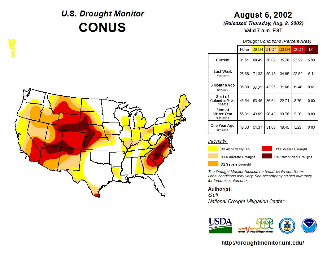
Click here to go to the US Drought Monitor website. Here’s an excerpt:
Summary
This week, most of the western and northern portions of the country recorded below-normal temperatures while most of the south was above normal. Active weather from the central plains into the Midwest brought above-normal precipitation over much of the region while the dryness intensified over the south and into the Gulf Coast…
High Plains
Most of the region was cooler than normal this week, with departures of 2-4 degrees below normal from northern Kansas into the Dakotas. Areas of southern Kansas and eastern Colorado were 2-4 degrees above normal for the week. Above-normal precipitation was confined mainly to portions of northern and eastern Kansas, western and central Nebraska, western and eastern South Dakota and western North Dakota, with departures of up to 3 inches above normal observed over north central Kansas. With the cooler conditions and recent rains, D0 was removed from most of Nebraska and northwest Kansas with D1 improving in Kansas as well. In the Dakotas, D0 was removed from southeast North Dakota and northeast South Dakota as well as north central South Dakota. The remaining D0 in east central South Dakota was shifted to include more of the agricultural areas west of Sioux Falls…
West
Cooler than normal temperatures dominated the west this last week. Most areas were normal to 5 degrees below normal for the week, with only areas of southeast New Mexico 5-10 degrees above normal. Monsoonal moisture continued to push into the southwest and into portions of Utah and Nevada. Some areas of Arizona were 2 inches above normal precipitation for this week. With the scattered rains, improvements were made to the D2 in southern California as the last several monsoons have been beneficial to this region and precipitation values are near normal over the last 3 years. Improvements were also made in northeast Utah where D1 improved to D0 this week. Continuing on the improvements started last week over northern Nevada, D2 conditions were pushed to the west, improving the D3. Nevada also showed the return of D4 in the west central portion of the state. The earlier rains in the region that allowed for D3 have since subsided and the impacts are again present, especially in the agriculture and ranching communities, allowing for D4 to expand this week. In Washington and Oregon, D3 conditions were pushed to the west as low flows on rivers and streams and warm water temperatures are impacting the region. In Idaho, D3 was expanded in the northern portion of the state where conditions continue to worsen, while some improvement to D2 was shown in the southeast as recent rains helped the region…
Looking Ahead
Over the next 5-7 days, the monsoonal moisture in the southwest is anticipated to remain in place, bringing with it up to an inch of rain over portions of New Mexico and Arizona. Some of this moisture will push up into portions of the Great Basin as well as the central and northern Rocky Mountains, where up to an inch of rain is anticipated in parts of Utah and Colorado. The active pattern will remain over the high plains and Midwest, where 2+ inches of rain are anticipated in portions of northeast Nebraska, southeast South Dakota and southwest Minnesota. The southeast will see more moisture, especially along the coastal regions where up to 3 inches is projected. Temperatures are expected to be above normal over the west, the southern plains, and the eastern third of the United States, with departures of 3-6 degrees above normal. The high plains and northern Rocky Mountains look to be 3-6 degrees below normal during the next week.
The 6-10 day outlooks show that most of the country has the potential to have good chances of above-normal temperatures, with the greatest probability over the west coast and from New England into the Mid-Atlantic. The exception to this is the high plains and Rocky Mountain region, where the best chance of below-normal temperatures is expected. The eastern half of the United States has the expectation of above-normal precipitation during the period while the area from California into the Great Basin is projected to have the probability of below-normal precipitation.
EPA is committed to working closely with response agencies and state and local officials to ensure the safety of citizens, respond to concerns and to evaluate impact to water contaminated by the spill.
Staff Deployed
EPA has deployed ten On-Scene Coordinators in Silverton, Durango and Farmington, New Mexico. Water quality experts and several technicians and contractors will respond to the discharge as it reaches communities in New Mexico.
Two Public Information Officers (PIOs) are also on site in Durango at the Joint Information Center (JIC).
In EPA’s regional office in Denver, there are 21 employees and one contractor providing support services to the response.
Several incident management team positions are being deployed to Durango.
Two Community Involvement Coordinators (CICs) were deployed to Farmington on August 9 and will meet with local Navajo chapter officials and host public meetings. The CICs will also partner with Navajo Nation EPA (NNEPA) and Navajo Department of Public Safety to ensure comprehensive outreach to all affected Navajo chapters.
We have tapped into several contracting mechanisms to provide support for the response, which includes water quality sampling, drinking water and agricultural water distribution as well as construction and maintenance of the water treatment ponds.
Water Monitoring, Sampling and Data Collection
EPA teams are deployed throughout the Animas River corridor collecting data. We collected water quality samples from nine locations in the river near intakes for Aztec, Farmington, Lower Valley Water Users Association, Morning Star Water Supply System and the North Star Water User Association. Each of these locations will continue to monitor as the release makes its way past these areas. Our Mobile Command Post arrived in Farmington on August 9. At the request of New Mexico Environmental Department (NMED), we are sending additional scientists and technicians to New Mexico to assist with water quality monitoring, sampling and outreach.
Collection, transport and lab analysis of metals in water is complex and time consuming. Workers at the lab and data experts are working continuously to evaluate and summarize the data.
The incident, which occurred on August 5, caused a spike in concentrations of total and dissolved metals as the contaminated mine water moved downstream. These concentrations began to trend toward pre-event conditions in the vicinity of the spill by the following day. We continue to monitor river conditions at multiple locations to detect trends. Rain events and variations in stream flows can cause the pH and metals concentrations to rise and fall. EPA is working with state and local government officials to determine when to reopen both drinking water intakes and open the river for recreation.
The contaminant plume is depositing sediments and we are beginning to assess the impacts of the sediment.
Mine Discharge Treatment
We are treating the mine water in a series of settling ponds constructed near the portal. The treatment appears to be effective. We are raising the pH (acidity) of the water with the addition of lime and sodium hydroxide solution to facilitate sedimentation of the metals in the ponds. We are adding flocculant agents (used in water treatment processes to improve the sedimentation or filterability of small particles) to increase the amount of sedimentation. The treated water that is being discharged to Cement Creek has a pH of 5.5.
Aerial Observation to Determine Extent of Release
EPA’s ASPECT (Airborne Spectral Photometric Environmental Collection Technology) plane observed that the conditions from Farmington to Durango show improvement. While the San Juan River remains discolored, the leading edge of the contaminant plume is no longer visible. These visual observations are a useful indicator, however, water quality data will provide the definitive information about river conditions. Learn more about ASPECT.
Coordination among EPA Offices and with State, Local and Tribal Governments
EPA’s Region 8 office in Denver, which is responsible for the implementation of our programs within Colorado, Utah and other Rocky Mountain states, is working in close coordination with:
EPA’s Region 6 office in Dallas, which implements our programs in New Mexico and other South Central states,
EPA’s Region 9 offices in San Francisco, which implements our programs in Arizona and in other Southwest states,
the states of Colorado, New Mexico, Utah,
the Southern Ute tribe and the Navajo Nation, and
San Juan County, City of Durango and Town of Silverton.
Outreach and Communication
EPA is sharing information as quickly as possible with the public as experts work to evaluate any effects the spill may have on:
drinking water,
public health,
agriculture,
fish and wildlife.
For more details, see the section below, and our regular updates on the response, which will be published as they become available.
Which Other Organizations are Involved in the Response?
U.S. Geological Survey (USGS) – USGS measured increased flows using a stream gauge for 6+ hours on August 9. This resulted in a provisional calculated flow volume of 3,043,067 gallons discharged from the Gold King Mine. EPA’s original estimate of one million gallons discharged from the Gold King Mine was based on an estimate of the size of the adit. A stream gauge is an instrument that measures volume by measuring flow, which is much more precise.
U.S. Agency for Toxic Substances and Disease Registry (ATSDR) – we are coordinating with ATSDR in response to public health concerns/questions associated with the mine waste plume. ATSDR has been in communication with local health officials at San Juan Basin Health in La Plata County (Durango) and the San Juan County Health Department in Silverton, Colorado. Public health questions/concerns should be directed to Chris Poulet, ATSDR/R8 at 303-312-7013.
New Mexico Environment Department – we are working closely with the New Mexico Environment Department (NMED) to evaluate possible impacts in New Mexico. Potentially impacted water systems have been notified and precautions are in place to ensure drinking water in homes is protected. With NMED, we are providing free water quality testing for private drinking water well owners in the affected area as well as providing water quality monitoring for the five drinking water systems with intakes from the river.
Colorado Fish and Wildlife Conservation Office has been monitoring the effects of the spill on terrestrial and aquatic wildlife since the incident began. CPW is watching for any impacts on wildlife, whether they are acute or chronic. Fish are especially sensitive to changes in water quality. CPW is also monitoring a control station on a clean tributary. The Colorado Department of Public Health and the Environment is assisting with drinking water concerns. They indicated they are optimistic that the effects of the spill on terrestrial wildlife will be minimal.
Navajo Nation and the Bureau of Indian Affairs – Our Region 9 office in San Francisco is working with the Navajo Nation and the Bureau of Indian Affairs. The discharge has moved quickly and is in the vicinity of the Navajo Nation boundary, near Kirtland, New Mexico. Navajo officials have reacted quickly, assessing their well fields and drinking and irrigation water intake systems and issuing a precautionary “do not use” public service announcement regarding water from potentially impacted sources. The Navajo EPA surface water monitoring program (Shiprock office) collected water and sediment samples from the San Juan River, prior to the impact of the release. Region 9 provided two contractors and four additional personnel to coordinate and conduct increased sample collection and lab analysis.
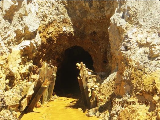
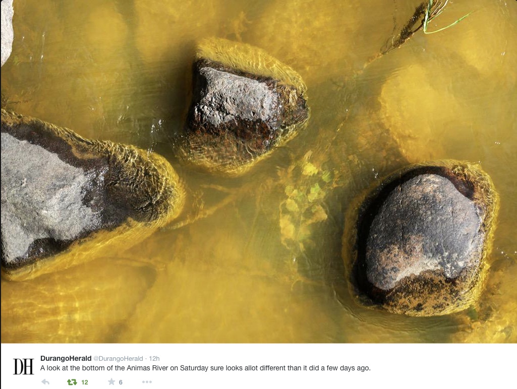
Mustard-colored water in the Animas River of southwestern Colorado illustrates more than anything else the long gestation time of many environmental disasters.
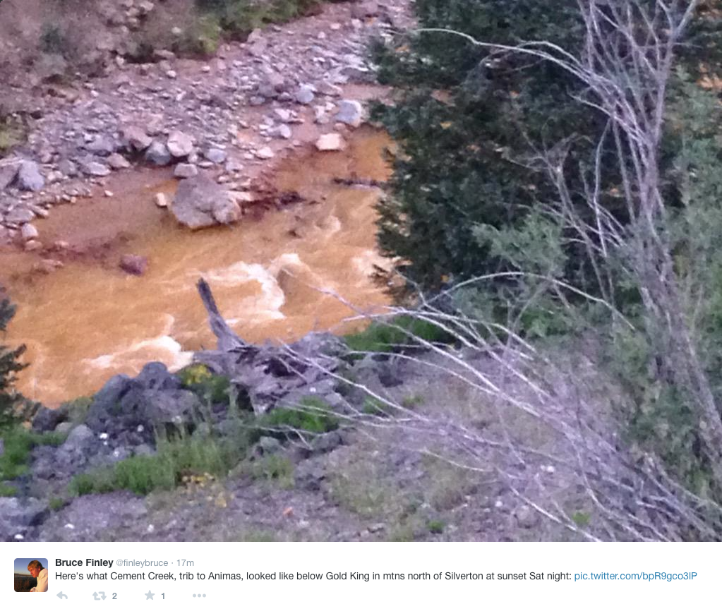
The surge was unleashed last week by a contractor working for the Environmental Protection Agency who unwittingly breached a dike, allowing contaminated water backed up in the Gold King Mine to flood into Cement Creek, a tributary of the Animas. The images from the river downstream in Durango were appalling.
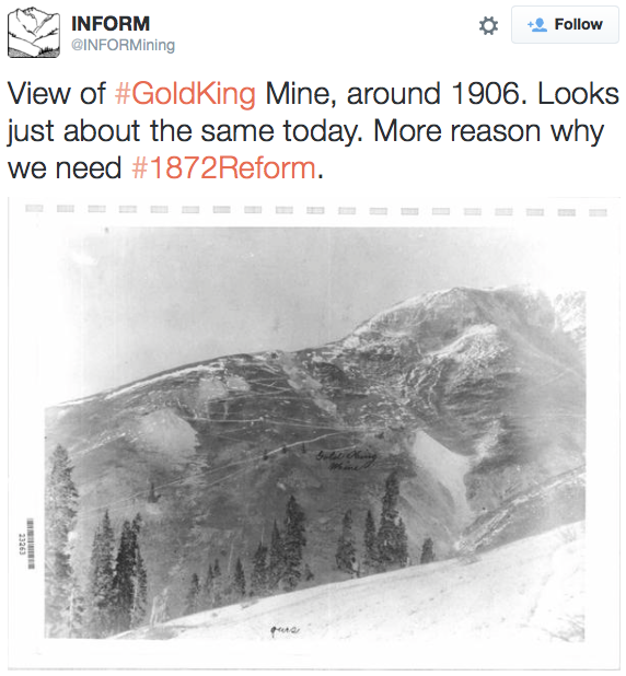
The makings for the disaster, however, began almost 130 years ago. Located seven miles north of Silverton at an elevation of 11,400 feet, the Gold King was among several big mines and mills clustered around a company town called Gladstone. The Gold King had a brief but productive life. The mine was staked in 1886 and the vein that made it a bonanza was identified in 1896. Until mine portals were shuttered in 1922, it produced $8 million in ore. That was more than a tenth of all production in San Juan County, according to “The Rainbow Route,” a railroad and mining history.
If a bonanza to owners, the mine was deadly to workers. Six people died of carbon dioxide drawn into the mine by a fire at the nearby boarding house. Another five people died in an avalanche, reports Scott Fetchenhier, an amateur historian and San Juan County commissioner.
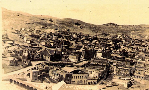
Central City back in the day
Mining can be hazardous to people living downstream, too. In the 1930s, farmers along Clear Creek, northwest of Denver, complained bitterly of their irrigation water being sullied by gold miners upstream at Central City and Blackhawk, to the detriment of their crops.
Eagle Mine
Even after state and federal laws were enacted, seeking to curb pollution, we’ve continued to cut corners. When mining ended in 1979 after a century at the Eagle Mine, located a few miles from Vail, Colo., a giant mess remained. Pollution made people uncertain whether they should eat fish caught in the Eagle River.
That question was soon answered. The settlement between the mining company and Colorado regulators assumed that sealing the mine would prevent water from flowing into the rivers. The experts were wrong. By early 1990, the Eagle River looked like Kool-Aid. The fish vanished. Belatedly, the EPA was called in and, after $100 million, the pollution has largely been cleaned up. However, heavy metals must continue to be removed from water in the mine before it gets into the river. The last time I checked, in the 1990s, the plant cost $1 million a year to operate. This will continue in perpetuity.
Summitville Mine superfund site
That cost near Vail is being borne privately, by a corporate conglomerate. Not so the $155 million cleanup at Summitville, an open-pit mine in southern Colorado where cyanide was used to extract gold from low-grade ore. After the mess became public, Galactic Resources filed for bankruptcy in 1992.
Bonita Mine acid mine drainage
Mines from around Silverton had been causing trouble long before this spill. The Silverton Standard & Miner had reported that water quality has worsened 2005. Four of five trout species in one area had vanished.
Since 1995, the non-profit Animas River Stakeholders Group has been working to address these legacy problems. It has been thwarted by absence of federal Good Samaritan legislation. Independent groups can’t afford to touch problems like the Gold King because, in case of accident, they “own the damages,” in the words of Ken Neubecker, of American Rivers, a conservation group. He explains that environmental communities worry that Good Samaritan legislation will allow big mining corporations to skip out on their responsibilities, such as occurred at Summitville.
The larger lesson derived from this giant mess in Silverton and Durango is that mining just doesn’t belong in headwaters areas, says Matt Rice, director of the Colorado River Basin program for American Rivers. He cites a copper-mining proposal for the Smith River in Montana. “Eventually, inevitably, the (contaminated) water will make it back to the river, whether it’s by catastrophic accident or a natural event,” he says.
I take a bigger view yet. Don’t blame the miners of 100 years ago. I have friends whose parents and grandparents worked at these mines near Silverton and Vail. They led hard lives.
But today we know better. We also know better than to pollute the atmosphere with reckless abandon, creating a bigger, denser greenhouse around the planet. Yet we keep doing it. People want 100 percent certainty. People complain about the costs. Right now, I’m wondering which would have cost more on the Animas River, prevention or cleanup.
From the Associated Press (Matthew Brown And P. Solomon Banda) via The Denver Post:
The spill of toxic wastewater from an abandoned gold mine high in Colorado’s San Juan Mountains caused untold millions in economic disruptions and damages in three states — to rafting companies, Native American farmers unable to irrigate, municipal water systems and possibly water well owners. And largely because the federal government inadvertently triggered the release, it has vowed to pay the bill.
That bill could be years in the making. Attorneys general from Colorado, New Mexico and Utah vowed to ensure citizens and towns are compensated for immediate and long-term damages from the spill. But Colorado’s attorney general, Cynthia Coffman, acknowledged it could be years before the full impact is known.
“We have to be vigilant as attorneys general, as the lawyers for the state, as protectors of the environment, to be sure that the assurances that we received today from the Environmental Protection Agency are the same in two years, in five years, even 10 years when we discover what the damage to the environment actually is,” Coffman said Wednesday after she and her counterparts gathered in Durango.
EPA administrator Gina McCarthy said her agency took full responsibility for the spill, which was unleashed Aug. 5 when an EPA-supervised crew accidentally unleashed the torrent of wastewater from the Gold King mine. The plume of heavy metals, including arsenic and lead, flowed into southwest Colorado’s Animas River and into the San Juan River in New Mexico.
McCarthy also said she had ordered agency personnel across the country to cease field investigation work on abandoned mines while the spill was investigated. EPA officials said they were seeking details on what the stop-work order means.
The Gold King spill was proving devastating to the Navajo Nation, which recently negotiated a settlement giving it rights to water from the San Juan River. The tribe plans to build a $20 million water treatment plant in northwestern New Mexico to take in the extra volume of water granted by the settlement and provide a clean drinking source to more of the 16,000 families on the reservation who still haul water to their homes.
Heavy metals already were present in the tribe’s underground aquifers, and “now those same things are dumped in the river,” complained Rex Kontz, deputy general manager for the Navajo Tribal Utility Authority. He said meeting EPA standards for clean drinking water could double the plant’s cost and require millions more in operating costs each year…
Current Colorado law requires a mining company to post a bond to cover the eventual cost of cleanup before a permit is issued to start operations, said Tony Waldron, supervisor of mine programs for the state Division of Reclamation, Mining and Safety. If the company fails to clean up the site when the mine closes, the state uses the bond to hire a contractor to do the work.
In most cases, the bonds have been sufficient to cover the cost of cleanup when mine operators don’t finish, Waldron said. The state has a fund it can use to make up the difference.
But the Gold King Mine isn’t covered because it was abandoned in 1923, before the law was in effect. In the absence of an owner, the federal government was working with local residents and the state to do limited mitigation work in the area around the Gold King mine — one of a cluster of old and polluted mines perched more than 11,000 feet high — when the spill occurred.
Cleanup costs alone can be staggering — and continuous.
Colorado tightened its bond requirements in the 1990s after the operator of the Summitville gold mine in southern Colorado, Summitville Consolidated Mining Co., declared bankruptcy and couldn’t complete a cleanup. Summitville became a federal Superfund site, with the EPA in charge.
The cleanup is ongoing because contaminated water continues to drain from the mine. The total cost to date is more than $100 million, according to the U.S. Geological Service.
Authorities said Wednesday that the waste from the Gold King spill will continue to be dangerous when contaminated sediment gets stirred up from the river bottom.
“There will be a source of these contaminants in the rivers for a long time,” said hydrologist Tom Myers, who runs a Nevada-based consulting business. “Every time there’s a high flow, it will stir it up and it will be moving those contaminants downstream.”
EPA spill liaison Nat Miullo suggested the danger from the spill had diminished with the dissipation of the initial burst of tainted water. Any future spike in contaminant levels caused by stirring up sediments would be “much, much smaller in scale,” he said.
But environmental regulators in downstream New Mexico warned that it was crucial to determine where the contamination settles.
“Those are some of the longer-term issues that affect humans as well as wildlife,” New Mexico Environment Secretary Ryan Flynn said.
Seven days after her agency’s massive mine wastewater spill into a major southwest watershed, the head of the Environmental Protection Agency said water quality in the Animas River through La Plata County has “returned to pre-event conditions.”
Administrator Gina McCarthy, in a boots-on-the-ground appearance Wednesday in Durango that’s expected to continue Thursday in Farmington, N.M., called the Aug. 5 incident “heartbreaking” and said the EPA “couldn’t be more sorry.”
“Right now, rest assured, we will learn lessons from this, and we will move those lessons forward in the work moving ahead,” she said of the spill of 3 million gallons at the Gold King Mine near Silverton.
In a 15-minute news conference, McCarthy said cleanup operations at similar mines throughout the country have been “put on hold” until the EPA determines how the Gold King accident happened. Speaking outside a command center, McCarthy said the EPA plans to solicit an independent investigation of the calamity.
Not satisfied
Some Durango residents are angered that McCarthy is neither planning a trip to the Gold King Mine nor holding a public meeting. EPA officials and McCarthy said the mine — roughly a 55-mile trip, some of it over unpaved road — was too far to visit.
“As you know, it is a significant distance away, but I did visit the river. I took a look at it myself to get a sense of the river,” McCarthy said. “And I think the good news is it seems to be restoring itself, but we have continued work to do and EPA is here.”
Her appearance came after Colorado’s senators and the congressman representing Durango-area residents urged her to visit the impacted areas.
“The most important thing for me, for this trip, was to come to the unified command center,” she said, citing a necessity to meet with local and state officials to ensure that their needs are being fulfilled.
“That is my first order of business,” she added…
Just before McCarthy addressed the media Wednesday afternoon, members of the Colorado and New Mexico congressional delegations released a letter they sent to President Barack Obama requesting federal resources. In the letter, the group also said the federal government should explore creating a water-treatment plant in the Upper Animas River to remove heavy metals from the watershed at its source.
While the EPA says it’s treating contaminated water still flowing from the Gold King Mine, three adjacent mines continue to release more than 540 gallons per minute of waste laced with heavy metals.
Looking ahead
Asked about what politicians across the Southwest have complained was a slow response by the EPA to notify the public of the spill, McCarthy said, “We will address those issues as we look at the investigation. … .
“The most important thing is we are moving forward. We are fully ramped up. We have data coming in. We can assess that data.”
Wednesday afternoon, the Colorado Department of Public Health and Environment informed the city of Durango that “drinking water treatment facilities can begin to use the Animas River to collect and treat water for customers.”
The Animas River in La Plata County, including Durango, remains closed by authorities. The county sheriff’s office has not said when it will reopen the water. Meanwhile, local businesses that rely on the Animas’ flow remain shuttered.
EPA officials Wednesday said the plume of contaminants is approaching Lake Powell in Utah and that apparatus are in place there to conduct testing.
“We are already there,” McCarthy said.
Utah Gov. Gary Herbert on Wednesday declared a state of emergency, saying his state has mobilized resources.
A spokeswoman for the San Juan Basin Health Department on Wednesday said results of water testing on private wells in the area have not been returned but are expected “very soon.” A county spokeswoman says the EPA is paying for the tests.
The department earlier this week said a call center set up to answer questions and take requests for well testing was “overwhelmed.” Samples have been sent to labs in Denver and Georgia.
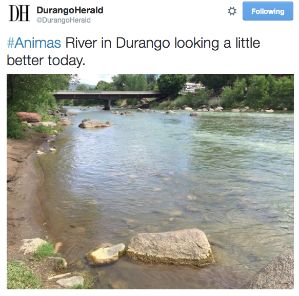
Animas River August 9, 2015 photo via The Durango Herald
From the Associated Press (Susan Montoya Bryan and Ellen Knickmeyer) via the (The Pueblo Chieftain:
Russell Begaye stared at the yellow water that keeps pouring out of a hole in the side of a Colorado mountain, racing down a slope and dumping heavy metals into rivers critical to survival on the nation’s largest Native American reservation and across the Southwest.
At the Gold King Mine, Begaye, president of the Navajo Nation, couldn’t help but see the concerned faces of his people — the farmers who can’t water their corn now, and the ranchers scrambling to keep their cattle, sheep and goats away from the polluted San Juan River.
“We were told that the water was clearing up and getting back to normal,” he said. “This is what EPA was telling us. We wanted to go up there as close as we could to the source. We wanted our people to see the water is still yellow.”
Climbing unannounced past barriers and up the mountain, Begaye and a small contingent of Navajo officials got a closer look over the weekend at the mine blowout sending more than 3 million gallons of water laden with lead, arsenic and other metals into Cement Creek, then down the Animas River and into the San Juan River.
A 100-mile-long plume has since traveled for hundreds of miles, through parts of Colorado, New Mexico and Utah on the way to Lake Powell, a key source of water for the Southwest. And the yellow sludge has been diluted along the way to the point of transparency, but authorities were still concerned about potentially toxic metals in the plume.
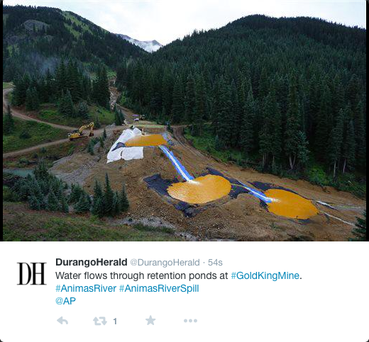
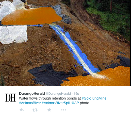
Yellow sludge still poured Wednesday from its source at the mine, 11,300 feet high in the Rockies, where an EPA cleanup crew hastily built a series of four sedimentation ponds by moving small mounds of earth covered in plastic.
EPA officials said Wednesday that these ponds aren’t retaining the flow, but they are reducing acidity levels and removing dissolved metals from the water from the runoff flowing into Cement Creek. That flow continues at pre-spill levels of about 213 gallons per minute, but is spreading less contamination than it did before last week’s accident.
Signs are now posted warning people to stay out of the water. Farmers have stopped irrigating and communities have closed water intake systems. Bottled water on the Navajo Nation is becoming scarce.
Begaye said his tribe is bearing the brunt of the massive spill that was accidentally unleashed by EPA workers inspecting the long-idled mine above Silverton, Colorado, on Aug. 5. Two-thirds of the San Juan River crosses Navajo land before reaching Lake Powell.
“This is a huge issue,” Begaye said. “This river, the San Juan, is our lifeline, not only in a spiritual sense but also it’s an economic base that sustains the people that live along the river.
“When EPA is saying to me it’s going to take decades to clean this up, that is how long uncertainty will exist as we drink the water, as we farm the land, as we put our livestock out there near the river,” he said. “That is just, to me, a disaster of a huge proportion.”
Frustration is mounting throughout the Four Corners region among officials and residents who say the EPA has moved too slowly and hasn’t been forthcoming about the dangers of the spill. The Navajo Nation feels even more slighted given its status as a federally recognized tribe and sovereign nation.
Begaye said he has yet to receive a call from President Barack Obama. “It seems like the Obama administration just closed their doors and disappeared,” he said.
On Wednesday, EPA Administrator Gina McCarthy planned to tour sites in New Mexico and Colorado affected by the spill. She called it a tragic and unfortunate incident, saying the EPA was taking responsibility to ensure the mess was cleaned up.
“I am absolutely, deeply sorry that this ever happened,” she said Tuesday in Washington.
The EPA has said the current flows are too fast for the contaminants to pose an immediate health threat, and that the heavy metals will likely be diluted over time so they don’t pose a longer-term threat, either.
Tests show some of the metals have settled to the bottom of the rivers and would dissolve only if conditions became acidic, which experts say isn’t likely.
Fish testing was going on Tuesday in the Animas River near Durango, Colorado, with biologists working to determine the leak’s impact on fish.
“We didn’t have a big fish kill in the river,” said Jim White, an aquatic biologist with Colorado Parks and Wildlife. “The one thing we don’t know is sort of long term impacts to the aquatic community out here in general.”
Colorado Gov. John Hickenlooper visited a contaminated stretch of the Animas and said he hopes a “silver lining” to the disaster will be a more aggressive state and federal effort to deal with mining’s “legacy of pollution” across the West.
On the Navajo Nation, some 30,000 acres of crops are in danger without irrigation. Farmers also worry about contaminating their irrigation ditches once the gates are reopened, and ranchers are looking for assurances that livestock won’t be exposed to contaminants each time they wade into the river and kick up sediment while getting a drink.
Navajo farmers are in the middle of alfalfa season and without rain, tribal officials say they will be in trouble. They have been flooding the airwaves and social media with Navajo-language public service announcements to keep people updated.
Federal officials have said they are working to review and analyze data gathered from samples taken along the two rivers.
McCarthy said Tuesday that initial results show high levels of contaminants in the water have been diminishing as the plume moves downstream. Workers have built four ponds at the mine site to capture and treat additional discharges, she said.
Heavy metals from Gold King and other defunct mines in Colorado have been leaching out and killing fish and other species for decades as rain and snowmelt spills from abandoned, exposed sites.
The EPA has considered making part of the Animas River in Colorado a Superfund site for a quarter-century.
The designation would have provided more resources for a cleanup, but some people in Colorado opposed the status, fearing the stigma and federal strings attached, so the EPA agreed to allow local officials to lead cleanup efforts instead.
A “get well soon” balloon floats in the contaminated waters of the Animas River flowing through Durango on Monday afternoon — photo The Durango Herald, Shane Benjamin
There is good news — believe it or not — bad news and, most significant, revealing news seeping out along with the acidic heavy metals flooding into the Animas River basin this week.
The bad news, as most are by now aware, comes in the form of the sludgy orange cocktail of arsenic, lead, copper, cadmium and other heavy metals that poured into Cement Creek and the Animas on Thursday after an EPA crew accidentally triggered a blowout of the Gold King Mine near Silverton. An estimated 3 million gallons of mine wastewater flooded into the river and took the water well beyond the state water quality levels for several heavy metals, especially lead, which measured at an astounding 5,720 parts per billion (ppb) shortly after the spill. The acceptable threshold for the state’s domestic water quality standard is 50 ppb.
Comparably elevated levels of cadmium, arsenic, iron, copper and manganese were recorded at a location 15 miles north of Durango a day after the Gold King blowout, although the levels of acidity had been severely lowered and contamination is expected to be further diluted over time.
And so begins the upbeat element of the report out of southwest Colorado. Better still is that the initial impacts to fish swimming in the Animas near Durango do not yet appear to be severely detrimental. Only one of 108 caged fish placed in the river by Colorado Parks and Wildlife officials died during the first 24 hours in the mustard-yellow water. Monitoring of macro-invertebrates in the river has been similarly positive, although that could clearly change as sediment settles on the riverbed.
Colorado Parks and Wildlife broadcast video Tuesday of fingerling rainbow trout introduced in the Animas River just before the big plume of contaminated water hit Thursday. Five days after the spill, the fish “appear to be in pretty good shape,” a CPW biologist said. The fish will now be submitted for analysis of heavy metal accumulation as on-site teams assess impacts of heavy metals on the river over the next several weeks if not months.
Although the long-term repercussions remain to be determined, the greater impact may prove to be that of perceptions.
Local fly-fishing shops already have reported being inundated with phone calls from people considering canceling their fishing trips to Durango, unaware of multiple other available fishing options in the region.
This is far from the first time heavy metals have spilled into the Animas River. Despite its Gold Medal trout fishing designation in the heart of Durango, the fishery has suffered for decades due to mine seepage, and annual stocking is necessary to sustain fish populations.
[Mark Esper] said the red rocks in Cement Creek have always been red and life in the creek and the Animas River in that area has always been scarce.
That is because for decades the mines in the Upper Animas district have leaked acidic water laced with various heavy metals into Cement Creek, the result of almost a century of mining in the region.
And for decades, state and federal officials have talked about cleaning up the site using federal funds, but have faced opposition from local residents and mining companies.
Although many Silverton residents remain skeptical of the Environmental Protection Agency, some say it’s time for a federal clean up.
“We knew there was a problem at Gladstone (a ghost town near the mine),” said Bev Rich, chairwoman of the San Juan County Historical Society. “And we knew that we needed to deal with it. But we didn’t deal with it.”
Bill Simon, co-coordinator of the Animas River Stakeholders Group, said state officials began investigating water quality in Cement Creek in 1989 after discovering that aquatic life was nearly nonexistent in the river.
He said after extensive water quality testing, the EPA was ready to add the entire Upper Animas River watershed to the Superfund National Priorities List by 1994.
The Superfund was created through federal law in 1980 as a way to address abandoned hazardous waste sites that threaten public health or the environment.
The law provides federal funds to the EPA to perform long-term remediation of toxic sites and also seek compensation from parties liable for causing the damage.
The last active operation in the region, Sunnyside Mine, closed in 1991, Simon said, but the mining companies continued to oppose the Superfund designation long after, fearing that they would be held responsible for cleaning up the mine waste.
Simon said many local residents did not support the designation either, fearing it would discourage future mining projects and tourism.
On Monday, Chairman Ernest Kuhlman of the San Juan County (Colo.) Board of Commissioners explained the town’s attitude toward the Superfund thus: “It retires mining, for one thing, and it retires tourism, for another.”
Kuhlman said he remains skeptical of the Superfund designation, despite last week’s spill, but wanted to know the EPA’s plan for the site…
Simon said local residents, mine owners and operators, and others opposed to the federal designation formed the Animas River Stakeholders Group in 1994 to retain local control over what water standards were implemented.
Though the Superfund designation was avoided, the threat of litigation had an impact — Sunnyside Gold Corporation, a former mine operator, signed a consent decree in 1996 with the state of Colorado to continue to operate a water treatment plant on Cement Creek and clean up several abandoned mines in the Upper Animas Mining District.
In exchange, Sunnyside Gold Corp. would be allowed to plug the Sunnyside Mine, located near Gold King Mine, and end its clean-up responsibility in the region.
Sunnyside Gold Corp. completed about 17 remediation projects in the Upper Animas Mining District by 1999, according to the stakeholders group’s website.
The corporation installed concrete bulkheads in the Sunnyside Mine between 1996 and 2002, which closed the mine and stopped the discharge of hundreds of gallons of polluted water.
However, Todd Hennis, owner of the Gold King Mine and neighboring Mogul Mine, said Tuesday the plug didn’t actually stop the water.
“The Sunnyside water is going by various paths, faults, fissures, etc. and coming out the neighboring mine properties,” Hennis said.
Hennis said that Gold King Mine, until 2003, was discharging 7 gallons of polluted water per minute.
After 2003, Gold King Mine, Red & Bonita Mine and Mogul Mine began discharging hundreds of gallons per minute, according to EPA records.
After a lengthy court battle involving Hennis, Sunnyside Gold Corp. discharged its obligation to maintain the Cement Creek water treatment plant, which was shutdown.
With polluted waters pouring from several mines and no plant to treat it, the water in the upper Animas River began to degrade significantly.
“I have been begging Kinross (current owner of Sunnyside Gold Corp.) to step forward voluntarily and be proactive and address the issues,” Hennis said. “They were trying to get out of any potential liability at a very cheap price.”
Kinross issued a statement Tuesday.
The company described last week’s spill as a “very unfortunate incident,” but denied any involvement.
“Sunnyside mine workings have no physical connection to the Gold King and such a connection never existed,” according to the statement. “Sunnyside is not the cause of the water build up at Gold King.”
Marcie Bidwell is executive director of the Mountain Studies Institute, a nonprofit environmental research organization that has been involved in monitoring river changes since last week’s discharge.
She said Tuesday it was “very possible” that runoff from Sunnyside Mine escaped through fractures into nearby mines.
Since 2008, Simon said the EPA has talked about a “targeted” Superfund limited to the Upper Animas Mining District. Sunnyside Gold Corp., a member of Animas River Stakeholders Group, offered $6.5 million to address water quality issues in the targeted area.
The catch, according to Simon, was the EPA had to release Sunnyside Mine Corp. from liability.
“The EPA has not really bought off on that,” Simon said. “But the money is still there and the EPA recently requested they do some (remediation work) and pay for it from the $6.5 million fund, which is supposed to have risen to $10 million in that amount of time.”
According to Simon, the EPA has not agreed to release Sunnyside from liability.
Hennis said $10 million is not nearly enough to adequately remediate the mining district.
Simon said that since the Gold King Mine spill, he has reflected on his organization’s previous opposition to the Superfund designation.
“We were dead set against Superfund at the time, but I would not say that is the case now,” Simon said.
Martin Hestmark, assistant regional director for EPA’s Region 8, said Monday that he is talking with stakeholders about solutions, which may include building a new water treatment plant.
He said he does not regret that his agency was not more aggressive in seeking a Superfund designation for the site.
“It’s important that the affected communities be supportive,” he said. “That is an evolving process.”
Colorado Governor John Hickenlooper’s spokeswoman, Kathy Green, said the decision is up to the community.
“At this point, (Hickenlooper) plans to continue to work with the EPA and the community on response and recovery for the area, and in addressing other mines in the state,” Green said.
Larry and Cheryl Markwell own the Hungry Moose Bar and Grill in Silverton, which opened a year ago this month.
Both husband and wife described the Gold King Mine spill as a tragedy and said they were open to solutions.
“We have people that fish, canoe and raft (in Silverton),” Larry Markwell said. “If people aren’t in the water, they won’t be coming to eat.
Cheryl Markwell said the town was plagued by problems, including a housing shortage and expensive utilities.
“This town is full of talk,” Cheryl Markwell said. “It’s a town that needs to act.”
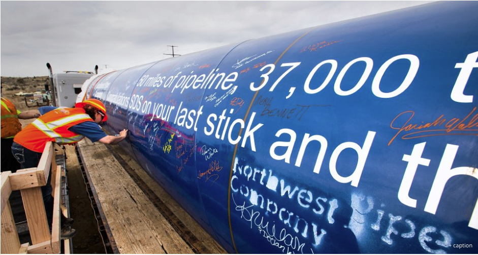
Decades of planning and an $829 million investment in Colorado Springs Utilities’ biggest water project ever will be put to the test next month, and the folks behind the Southern Delivery System can’t wait.
Like children anticipating new bicycles for Christmas, project leaders are eager – not anxious – for the tests to begin. Their confidence is matched only by their pride in the project…
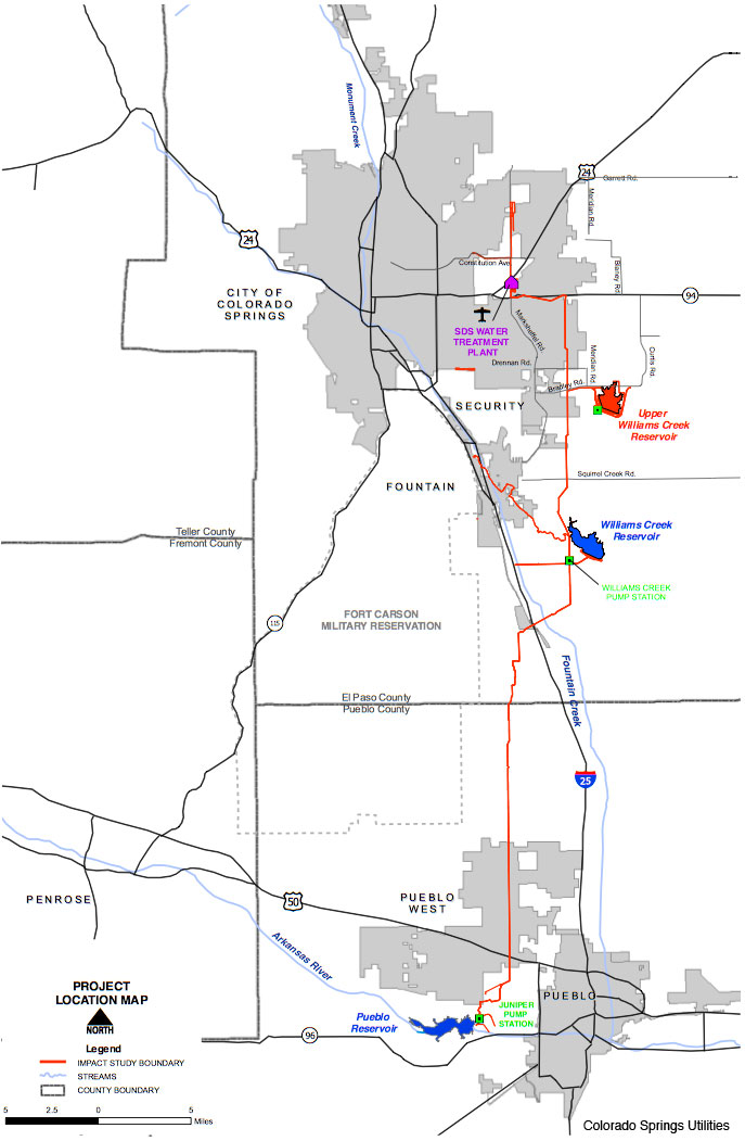
The water will flow from the Pueblo Dam through three new pump stations to a 100-acre water treatment plant built in Colorado Springs. The plant’s developed area alone could hold 77 football fields, noted Kim Mutchler, of CSU government and corporate affairs.
The entire system is to begin water delivery next April. But before it does, more tests will be done through September and October.
Since pipeline construction began in 2011, every piece of pipeline has been tested upon arrival, with each section water-tested once installed. Pump station testing started in July and is continuing into the fall, and small tests have been done for several months at the treatment plant.
Next month, tests are expected to begin sending water through multiple stages of treatment. Then several system-wide tests will be done through the fall before SDS starts serving customers next year…
Some of the biggest savings, says SDS Program Director John Fredell, came from the 3.62 percent interest rate on $180 million in 40-year bonds issued in September 2010. In all, $475 million in bonds have been issued.
But unforeseen cost cuts came, too, as engineers and others reviewed completed designs and plans, then unabashedly pointed to better, less expensive ways to accomplish what needed to be done.
To wit:
– The sprawling campus envisioned for the water treatment plant and its 10 million-gallon tank was reconfigured to put all essential functions under one roof, saving 4 miles of piping and more than $65 million.
– A contract engineer from the Broomfield-based MWH insisted that the three pump stations could be built for under $100 million, contrary to the contractor’s contention. So the project was rebid and built for $75 million. “Those are the benefits of having a really experienced engineer on your projects,” Fredell said.
– Several million more dollars were saved when a program leader noted that single welds instead of double welds could be used on pipes not handling high pressure.
– Another $10 million was saved when Dan Higgins, then the SDS construction manager, decided the pipeline beneath I-25 and Fountain Creek should be one long tunnel rather than a series of short tunnels using extensive open trenches, as envisioned by a consulting engineer. The new method also minimized impacts to floodplains, wetlands and mature trees.
SDS leaders also changed the type of pumps used, opting for more expensive $1 million vertical pumps – 11 in all – that will last longer, have lower electric costs and produce a higher discharge pressure, so another pump station didn’t have to be built in Pueblo.
“The most expensive commodity is electricity to push the water,” Fredell said.
But the humongous project also has brought financial benefits hidden to the casual observer.
When the SDS started in 2009, along with the recession, “We wanted this to be our own stimulus,” Fredell said. “We went on the road to Pueblo and El Paso and Fremont counties and did workshops on how to work with us.
Last section of pipe for Southern Delivery System photo via The Colorado Springs Gazette
“Only one company in Colorado can build this size diameter pipe. We got other companies from out of state to bid. But they (the Colorado firm) got over $100 million worth of business during the recession. This project helped keep them from having layoffs.”
Contracts set a goal of giving 30 percent of business to Colorado companies, with a penalty for those that didn’t.
“They’ve exceeded the local spend,” Fredell said. “We’ve had over 300 Colorado companies involved and spent $650 million through June, total, and $550 million has stayed in Colorado – $269 million to employers in El Paso County” plus $73 million in Pueblo County and $208 million elsewhere in the state.
The toughest part of the project has been the permitting and planning, he said, with more than 200 major permits obtained, and about 350 total.
The greatest challenges there were creating the 3,000-page Environmental Impact Statement (EIS), which took five years, and obtaining the 1041 Permit from Pueblo County.
The EIS was handled by Keith Riley, SDS deputy program director for CSU, with help from Bill Van Derveer, assistant SDS program director with MWH.
“The two of them were just brilliant in the way they approached it, got the science for the EIS, got all the people together, and worked well with all the agencies, including the EPA (U.S. Environmental Protection Agency),” Fredell said.
Two other key players, both now retired from CSU, were Gary Bostrom, chief water services officer, and Bruce McCormick, also a water services officer.
“That’s one of the things I’m proudest of, the people we’ve had work on this thing. They were just ingenious,” Fredell said. “The credit goes to people like that.
“This project has been so much fun. I’ve gotten all my white hair on this project. It’s definitely challenged everybody.”
The five-star Broadmoor hotel in Colorado Springs has spent $12 million to buy, rebuild and makeover the property that’s been one of the Pikes Peak region’s marquee tourist attractions.
The hotel has added picnic areas, a mining-themed restaurant and even zip-line courses – all with the goal of transforming Seven Falls into an attraction with a broader appeal to residents, tourists and hotel guests.
“It’s designed to be a multi-hour experience and not just something where you come in and look at the falls and you’re done,” said Broadmoor president and CEO Jack Damioli.
“We’ve taken a look at Seven Falls and reimagined it and came up with the beautiful, historical natural attraction, a fine restaurant and then this soaring adventure (zip-line courses), which will appeal to a different generation and those seeking more adventurous activities,” he said. “It’s not the old Seven Falls anymore.”
Seven Falls, in South Cheyenne Canyon on the Springs’ southwest side, dates to the 1880s. Oilman Al Hill bought Seven Falls in 1946, and his family owned it until last year. Seven Falls was known primarily for its scenic waterfalls – cascading down 181 feet of sheer granite cliffs – and the canyon, which has been billed as “the grandest mile of scenery” in Colorado.
In September 2013, torrential rains destroyed hiking trails, washed away a viewing platform at the foot of the falls, sent debris and sediment rushing through the area and caused other extensive damage that forced Seven Falls’ closure.
“When the flood came through, it cleaned the canyon out,” Damioli said. “The water came down and everything just flowed straight downhill and took everything in its path with it.”
The Broadmoor announced in April 2014 it was buying Seven Falls, and completed the deal a year ago – and has renamed the property as The Broadmoor Seven Falls. The purchase added another piece to what the hotel calls its wilderness experience.
Before installing a drip irrigation system at Fagerberg Produce, Rod Weimer said he didn’t know anything about computers.
More than 15 years later, Weimer is a whiz with the smartphone app that controls the irrigation in 850 acres of Fagerberg Produce fields, which he manages.
“My first thought was, ‘I don’t even know how to turn on a computer. How am I going to be able to do this?’ ” he said. “With the help of my daughters, I learned how to work the computers. Today, it’s like I knew it all my life.”
The Netafim subsurface drip irrigation system was installed at Fagerberg Produce in 1998, and it was the first of its kind in the state.
It still draws many visitors who want to learn more about the irrigation method, including an annual visit by some of Colorado State University’s agriculture studies students.
For his efforts in introducing Fagerberg Produce and the rest of Colorado to the drip irrigation system, Weimer last month was awarded the 2015 Precision Agriculture Farmer of the Year Award at the InfoAg Conference held in St. Louis, Mo.
Weimer, who lives in Eaton, was chosen out of farmers nominated from all over the country to receive the award from the PrecisionAg Institute.
PrecisionAg is described on its website as a diversified, independent media enterprise serving the global community using precision agriculture techniques — adjusting production inputs and practices based on in-field variability, typically through use of geographic positioning systems and other technologies
The Farmer of the Year award was won in partnership with Fagerberg Produce, a fact Weimer is always sure to highlight.
“Without the company, I wouldn’t have the resources to do what we did,” he said.
Fagerberg Produce owner Lynn Fagerberg has been extremely supportive of the whole project, he said.
“It’s so important to have an owner who allows you the resources and then it’s up to us to work,” Weimer said. “They give us those resources and trust us to do our jobs.”
The drip irrigation job wasn’t a short or simple undertaking, Weimer said.
In Colorado and westward — where farms fight for every drop of water to grow good produce — that water saving is important.
The Netafim system saves about 40 percent of the water output for the fields in which it sits, and it’s easy to manage.
“We’re running five farms in the 850 acres off my phone,” he said. “I can travel anywhere in the world and still access it.”
The system allows for more fields planted in drought years. Fields with drip irrigation typically see high yields and better crop quality, Weimer said.
He first heard of the systems at a Colorado State University event more than 17 years ago.
“From that point on I started researching drip, and I flew across the United States trying to find a system that would fit our needs,” he said.
In the late ’90s, it wasn’t easy to find such a technologically advanced system. In a time before a smart phone could be found in every pocket, the irrigation system relied on GPS and remote signals.
In the beginning, the innovation was taking place in Fresno, Calif., and most of the companies driving the technology didn’t want to set them up in Colorado because there was no service team nearby.
“Finally, after being very persistent I had a company that supported me and flew out and did a training on GPS so we could support it ourselves,” Weimer said.
He said it was scary, of course, but worth the effort.
Technology has improved through the years, and Weimer was able to evolve from running the system only from his personal computer to his smart phone today.
“It keeps changing and we keep adding,” Weimer said. “Every time there is a change, something new, something better, we add it.”
Weimer grew up in Kersey, and he’s been on a farm since birth, so he knew the importance of water conservation from a young age.
“I’ve always loved it,” he said. “I love playing in the dirt. I love seeing Mother Nature let you grow something fantastic.”
He’s been with Fagerberg Produce for nearly 28 years, and he said he wouldn’t have it any other way.
“I really want to stress that, yeah, it’s my name on the award and I won Farmer of the Year, but it’s a company involvement,” he said.
Those first few years of adjusting to the drip irrigation were a bit scary, but ultimately, Weimer said they made the right choice.
He said the first time they turned it on, there were leaks everywhere thanks to some hungry field mice.
“I think my neighbors thought we were crazy,” he said. “There was a learning curve.”
But they quickly worked out the kinks, and the system has been smooth sailing since.
“Lynn Fagerberg and myself, we’ve always been excited for change,” he said. “If you don’t keep up with the time — with the technology that’s available — it’s going to be hard to survive.”
Click here to go to the Environmental Protection Agency website. Here’s their summary:
On August 5, 2015, EPA was conducting an investigation of the Gold King Mine near Silverton, Colorado, to:
assess the on-going water releases from the mine,
treat mine water, and
assess the feasibility of further mine remediation.
While excavating loose material that had collapsed into the cave entry, pressurized water began leaking above the mine tunnel, spilling about three million gallons of water stored behind the collapsed material into Cement Creek, a tributary of the Animas River.
EPA is working closely with first responders and local and state officials to ensure the safety of citizens to water contaminated by the spill. The agency has activated its Emergency Operations Center to ensure coordination among its regions, laboratories and national program offices in Washington DC. EPA is closely coordinating with the officials in Colorado, New Mexico, Utah, Southern Ute tribe and Navajo Nation. EPA is taking the lead on efforts to contain the leak and flow from the mine is now controlled. EPA has also deployed federal On-Scene Coordinators and other technicians in Colorado, New Mexico and Navajo Nation to assist with preparations and first response activities in these jurisdictions. EPA is sharing information as quickly as possible with the community as experts work to analyze any effects the spill may have on drinking water and public health.
They have links to the technical data on the web page.
Map of the Northern Integrated Supply Project via Northern Water FromColorado Public Radio (Grace Hood):
Colorado’s water planners…see the Cache la Poudre as an opportunity to help quench Colorado’s seemingly endless growth and thirst for water. That’s why Northern Water has proposed building two large reservoirs on behalf of 11 cities. It’s a project that sets them in emblematic conflict with environmentalists and other groups.
Resolving environmental disputes on large-scale water projects takes time. So does the federal permitting process. Water managers say that even without the conflict, projects take years–sometimes decades–to acquire the necessary permits.
“We would not look to short circuit the diligence and the rigor associated with environmental permitting processes. That’s really important,” said Jim Lochhead, manager of Denver Water. “That having been said, the permitting process if you look at it in total between federal and state, and everything else we need to do is broken.”
The Northern Integrated Supply Project
To quench Northern Colorado’s growing thirst for more water, the local agency Northern Water has proposed the Northern Integrated Supply Project. The effort would build one reservoir north of Fort Collins, and another near Greeley. Once both reservoirs are filled, about 40,000 acre feet of additional water supply would be released every year from storage. Households typically use between one-half to 1 acre-foot of water annually.
We can’t conserve our way to future supply. No matter how we phrase it, you just can’t do it,” said Brian Werner with Northern Water.
Northern Water is pursuing the project on behalf of 11 cities along the Front Range. Werner said his agency wants an “all of the above strategy” to meet growing water demand. So it’s eyeing more conservation and the exchange of water rights from agricultural land. Agriculture uses about 80 percent of the state’s water supply.
There were environmental studies done on the river to evaluate problems and propose solutions. Mark Easter with the environmental group Save The Poudre said the measures don’t go far enough.
“I think there’s a new conversation that’s starting around this, asking the question, do we really need these reservoirs?” said Mark Easter, board chair of Save The Poudre.
A swinging pendulum
A century of dam projects across the West have caused ecological harm to some Western rivers. Today the federal permitting process to build a dam or a reservoir is far stricter compared to the early 1900s. But some water managers fear the pendulum has swung too far.
Take Denver Water. It decided in 2002 it needed to expand the reservoir outside Boulder. The agency won’t find out whether it can do this until later this year.
For large-scale projects, it’s up to the U.S. Army Corps of Engineers to decide whether a project gets built. But you need permits from other federal agencies. And there are state permits. Meantime, Denver Water has employees devoted full-time to moving the reservoir expansion forward.
“If we look at a future with climate change and rapidly evolving conditions in terms of climate, and weather and drought, we need to be a lot more nimble in our ability to build critical infrastructure in this country,” said Lochhead.
Water managers like Lochhead say a rigorous environmental assessment is needed for projects. What slows the process down is that each permit has unique requirements…
These two proposed reservoirs in Northern Colorado will take time and money before they get off the ground. The environmental group Save the Poudre says it will continue to fight these efforts. Meanwhile a final decision from the U.S. Army Corps of Engineers on whether these reservoirs can be built won’t happen until 2017 at the earliest.
Cement Creek aerial photo — Jonathan Thompson via Twitter
The confluence of Cement Creek, at right, and the Animas River, left, as seen September 2015 in Silverton, Colo. This is where the plume of contaminated water from the Gold King Mine entered the Animas River. (Jon Austria — The Daily Times)
This morning EPA is releasing a detailed data table of the sampling in Cement Creek and the upper portions of the Animas River from August 5, the date of the incident, and August 6.
EPA expects to have new data from August 7 which is currently undergoing review and will be available to the public later today. We acknowledge frustration with the turnaround time for this information. Workers at the lab and data experts are working continuously to develop the information.
The data table contains a list of analyzed constituents, largely metals, and their numeric value in micrograms per liter, which is equal to parts per billion, or ppb.
The data table released today will include updates to the information released by EPA on August 7. The incident, which occurred on August 5, caused an increase in concentrations of total and dissolved metals as the contaminated mine water moved downstream. These concentrations began to trend toward pre-event conditions by August 6. August 7 and 8 data, when it is available, will inform whether the trend towards pre-event conditions continues.
Note: Total metals analysis for water samples includes the metals content both dissolved in the water and present in the particulates in the water. Typically a dissolved metals analysis of a water sample is performed by removing the particulates with a filter, then analyzing the filtered water for metals.
Click here to read the EPA’s emergency response form.
Click here for the preliminary data analysis from th EPA.
Click here for the August 7 analysis from the EPA.
FromThe Denver Post (Bruce Finley and Tom McGhee):
The EPA on Monday expanded its response to the Animas River mining disaster, delivering bottled water in Colorado, New Mexico and Navajo Country and testing for contaminants as far as Lake Powell.
The acidic heavy metals that flooded into Cement Creek and the Animas in southwestern Colorado — including arsenic, lead, copper and cadmium — initially broke state water quality limits, based on data the Environmental Protection Agency has released.
Gov. John Hickenlooper declared a disaster. New Mexico also declared a disaster. California officials have been calling the EPA about water supply implications. Residents along the Animas near Durango, with about 17,000 people, swamped La Plata County with requests for well tests.
But five days after an EPA crew triggered the Gold King mine blowout, EPA regional chief Shaun McGrath still could not give an assessment of potential harm to people.
The spread of toxic heavy metals was such that authorities will block access to the Animas at least until Aug. 17 while the EPA develops “risk-screening criteria” and data show that water has returned to “pre-event conditions,” McGrath said.
“The risk-screening levels, that is based on exposures through different uses in this area,” he said.
“Are we back down to pre-event conditions? … That is going to take a little bit of time.”
An initial deluge of acid mine wastewater estimated at 3 million gallons brought the concentration of lead in the Animas River to 5,720 parts per billion (ppb), according to the EPA’s data — far above the Colorado Department of Public Health and Environment domestic water quality standard of 50 ppb, the shut-off point above which municipal water providers are told not to draw water into their systems…
The water data available Monday, from a location 15 miles north of Durango, were taken one day after the Gold King blowout. The contamination is expected to be diluted. EPA responders have set up new retention ponds below Gold King.
EPA on-scene coordinator Hayes Griswold explained to San Juan County, Colo., officials that an EPA team working at the mine on Wednesday underestimated how much pressure was hidden behind the debris that plugged the mine’s entrance.
He said the team was not attempting to dislodge the plug, but was instead attempting to stick a pipe into the top of the mine.
The pipe would allow the team to safely pump liquid out of the mine for treatment, Griswold said.
“We were very careful,” he said, adding that he has 28 years of mining experience.
However, the team removed too much material from the mine’s roof, which caused the rupture, Griswold said…
Griswold said Monday that the mine was discharging anywhere between 200 to 700 gallons per minute of polluted water.
The fluctuation in discharge was caused by cave-ins within the mine, which may temporarily slow the flow rate, Griswold said.
The water flowed down the mountain pooling in one of several man-made ponds a few thousand feet below the mine’s mouth where contractors treated it with lime, coagulants and caustic soda.
Griswold said he believed there were other mines in the area that posed a similar threat of rupturing.
A “get well soon” balloon floats in the contaminated waters of the Animas River flowing through Durango on Monday afternoon — photo The Durango Herald, Shane Benjamin
The Environmental Protection Agency said Monday it doesn’t anticipate any decisions on whether to reopen the Animas River in Durango until at least Aug. 17.
Local, state and tribal governments will likely make independent decisions based on different segments of the river and the impacts, said Shaun McGrath, administrator for EPA’s Region 8, which covers six states, including Colorado…
Also on Sunday, Gov. John Hickenlooper declared a state of disaster that will allocate $500,000 from the state’s Disaster Emergency Fund to help pay for the response to pollution the EPA accidentally released Wednesday from the Gold King Mine.
The governor plans to visit Durango on Tuesday.
The EPA also said it is ramping up its ground response by establishing a “unified area command center” in Durango with an incident commander who will coordinate operations in three agency regions that include Colorado, New Mexico, Utah, Arizona and California.
EPA scientists plan to create a “risk screening” analysis based on different uses. They will use data that is being developed to identify if contaminants are acceptable for agriculture, aquatic life, wildlife, recreation and human consumption. They will also indicate whether the levels of contamination are down to pre-event conditions.
EPA officials have repeatedly delayed providing a detailed analysis of whether metals in the yellow-brown plume were dangerous to aquatic life, wildlife, crops, skin contact and human consumption. Wildlife that drank from the river during the height of the event should be fine, they said, but, based on preliminary results, the EPA supports local officials’ decision to close the river to human activity.
La Plata County Commissioner Julie Westendorff said elected officials are as frustrated as county residents with the slow pace of sampling and data interpretation. Six days after the mine blowout, she still didn’t know if the same water quality is needed for different uses, such as agriculture, recreation or drinking. She hopes the EPA won’t delay giving the green light for some uses just because the river is unsafe for other uses.
“We’re looking at a river that looks pretty good,” Westendorff said Monday. “We all want evidence that we can start using it in some form or another.
Scientists outside the region are helping to make that call, she said. “I don’t’ get the impression there is someone sitting in this room here that is in a position to make that call.”
County officials are working to identify water wells that are in close proximity to the Animas River that may be tainted by the mine runoff in the Animas River.
A multi-agency team will conduct sampling upon request of well water if discoloration is observed or if residents are highly concerned. If discoloration is observed in well water or residents are highly concerned, the EPA will provide drinking water. The county is also helping to supply farmers and ranchers with water for their crops and livestock if needed.
“I want our irrigators to know they are a high priority,” Westendorff said…
Aerial and ground reconnaissance indicated Monday that the plume associated with the Gold King Mine has dissipated downstream and there is no leading edge of contamination visible in downstream sections of the San Juan River or Lake Powell.
Contaminated mine runoff continues to flow out of the abandoned mine. The EPA has constructed four ponds at the mine site, and they are treating water by lowering acidity levels and removing dissolved metals. The system is discharging treated water to Cement Creek at levels cleaner than pre-event, the EPA said Monday night in a news release. Over the next several days, EPA will make upgrades to the system to ensure its continued operation.
EPA continues to collect water samples daily from the Animas and San Juan rivers. Fish cages placed directly in the Animas River indicate no mortality as a result of the spill.
“To date, we have seen no indication of widespread fish mortality in the Animas or San Juan,” a news release said.
While lacking specific health and environmental impacts, the EPA is reporting a downward trend in water concentrations for metals at sample sites. The EPA recommends washing with soap and water after contact with river water to minimize exposure to the metals and any bacteria that maybe present in the untreated river water.
Dissolved iron in the waste turned the long plume an alarming orange-yellow – a look familiar to old-time miners who call it “yellow boy” – so “the water appears worse aesthetically than it actually is, in terms of health,” said Ron Cohen, a civil and environmental engineering professor at the Colorado School of Mines.
New Mexico Gov. Susana Martinez has declared an emergency that frees up state funds to address the wastewater plume as the Animas enters the state and joins the San Juan River.
FromThe New Mexico Political Report (Matthew Reichbach):
The spill is now three times the original estimate
The EPA originally estimated that the spill was one million gallons of contaminated water. This weekend, the EPA revised the estimation and now says the spill was closer to 3 million gallons.
Contaminated water is still leaking from the abandoned mine. From the Farmington Daily-Times:
The mine continues to discharge 500 gallons per minute, EPA Region 8 administrator Shaun McGrath said in a teleconference call Sunday afternoon, but the polluted water is being contained and treated in four ponds at the site of the spill near Silverton, Colo.
After the plume passes, the river appears to be moving closer to normal…
Why is it so toxic?
Chemical reactions.
OK, a better explanation:
For most of the West’s history, miners were basically allowed to run willy-nilly across the landscape, burrowing for gold, silver, or other valuable minerals. According to Ronald Cohen, an environmental engineer at the Colorado School of Mines, whenever you dig into a mountain, “at some point you are going to hit water.”
That water, when it runs through the rocks in a mine, hits a mineral called pyrite, or iron sulfide. It reacts with air and pyrite to form sulfuric acid and dissolved iron. That acid then continues through the mine, dissolving other heavy metals, like copper and lead. Eventually, you end up with water that’s got high levels of a lot of undesirable materials in it.
And that’s why there are now elevated levels of heavy metals in the river…
Abandoned mines are common
Until 1981, when a mine shut down for whatever reason, the owners could just essentially board them up and walk away. There was no requirement for rehabilitation plans or any plans to deal with the toxic materials left behind.
From Reveal, part of the Center for Investigative Reporting:
By some estimates, there are as many as half a million abandoned mines in the U.S. These sites have the potential to contaminate water, pollute soil, kill wildlife and sicken humans, to say nothing of the risks of falling down a hidden mine shaft. (This is a legitimate concern in some areas – in California, the state employs teams that scour the state looking for abandoned mines and plugging them up. There was even a “Dirty Jobs” episode about these folks.)
Spills aren’t uncommon either
The striking visual of the orange water flowing downriver, along with the massive size and cause of the spill, has created massive national interest in this spill. Smaller spills are relatively common throughout the West, as the Associated Press noted.
The federal government says 40 percent of the headwaters of Western waterways have been contaminated from mine runoff.
And Wired notes the same thing.
The abandoned mines in the area have long been a problem, filling up with acidic wastewater that leaches heavy metals out of rock and leaks into the river—a slow-motion environmental debacle. And the EPA has been trying to designate the mines a Superfund site for years, only to come up against local resistance. The mines still aren’t on the Superfund list, but the EPA has been trying to them clean up anyway.
In fact, the mine where the pollutants filled the Animas was itself leaking. The personnel were looking at the mine because of the pollutants that were seeping into the surrounding areas.
“These are historic abandoned mines that have had acid drainage for decades. That is the very reason why we were up there,” EPA regional chief McGrath said. “We were trying to reach that drainage coming off the Gold King Mine. They were trying to put in a treatment system.”
States of Emergency
The spill of pollutants has prompted areas to declares states of emergency. On Sunday, La Plata County and the City of Durango, both in Colorado, declared a state of emergency.
San Juan County in New Mexico declared a state of emergency this weekend as well.
The Navajo Nation declared a state of emergency and has already announced intentions to sue the Environmental Protection Agency over the spill that has disrupted life in the Four Corners area.
The state of New Mexico also will file suit.
Gov. Susana Martinez was the latest to declare a state of emergency, doing so Monday afternoon.
And one bonus thing, from another mine spill from over three decades ago.
Church Rock uranium mine spill
The Animas River spill is massive, but the 3 million gallons pales in comparison to another spill that slammed the Navajo Nation, 36 years ago.
A spill of radioactive material from the Church Rock Uranium Mine in 1979 leaked 94 million gallons of radioactive waste into the Rio Puerco.
New Mexico In Depth wrote about the spill last year, shortly before the 35th anniversary of the spill.
The radioactive material was a mixture of water and mill tailings, leftovers that retained toxic contaminants from the mining process that converted mined uranium into yellow slurry, known as yellow cake. The tailings were “placed in unlined evaporation ponds at the mill site,” the report says, meaning the radioactive goop that washed into the Puerco River and flowed through communities downstream was a public health hazard.
In 2009, shortly after the 30th anniversary of the spill, the Navajo Times wrote about the disaster, noting the health effects that have continued to impact the area decades later.
The Navajo Times story says the radioactivity was so bad that those who stepped in the water had blisters and and burns on their feet.
Click here to read the current issue. Here’s an excerpt:
If Colorado’s population grows by adding another three to four million people at mid-century, changes will occur in how our land is used. Today’s population hovers at 5.3 million and a few million more residents means Colorado’s cities, suburbs and country estates will inevitably spill onto today’s farms and pastures.
But how will they spill? And how will Colorado’s existing towns and cities reinvent themselves? Those are among the questions as Colorado peers toward the bottom of its water bucket, trying to calculate how revised land use can help bridge the gap between water supplies and expectations… it’s a golden opportunity to rethink the way we grow in Colorado. Read the full story, “From the Ground Up” in the new issue of Headwaters magazine here.
Gain insight on groundwater issues such as availability and quality, water scarcity, and low recharge rates being encountered in the Upper Great Plains, a growing and economically important region, during this NGWA conference.
The conference will primarily focus on the American states of Colorado, the Dakotas, Montana, Nebraska, and Wyoming, as well as the Canadian provinces of Alberta, Manitoba, and Saskatchewan — including the plains, mountains, and intermontane valleys of this region.
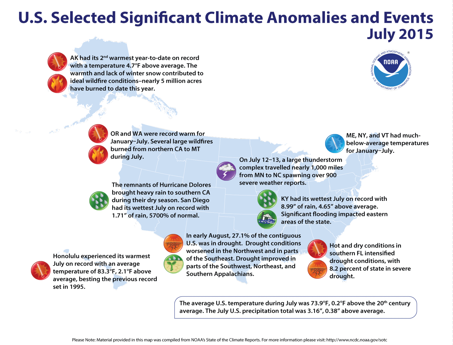
July 2015 warmer and wetter than average for the US
The Northwest and Southeast were warm while the central U.S. was cool. Record precipitation in parts of California did little to improve long-term drought.
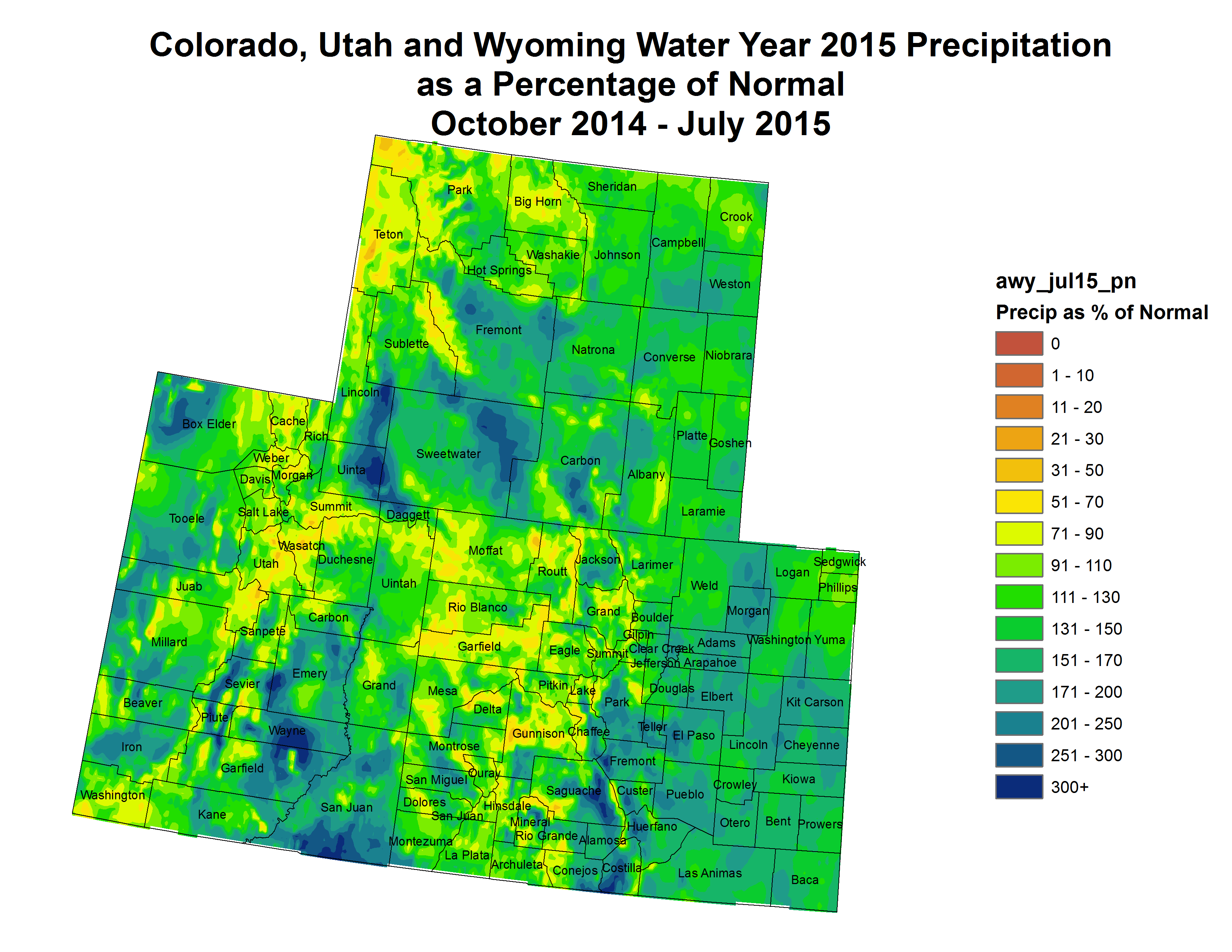
The July precipitation total for the contiguous U.S. was 3.16 inches, 0.38 inch above average. This was the 14th wettest July on record, and marked the fourth consecutive month of above-average precipitation for the Lower 48. Above average precipitation was observed across much of the West, Great Plains, and Ohio Valley. Below-average precipitation was observed in parts of the Southern Plains, Southeast, and Northwest.
July
Temperature
Above-average temperatures were observed in Alaska and the Northwest—Washington had its fourth warmest July. The Southeast was also warmer than average where Florida, Louisiana, Mississippi, and South Carolina were all much warmer than average. Louisiana had its third warmest July on record. No state was record warm.
Below-average temperatures stretched from the Great Basin, through the Central Rockies, and into the Central Plains and Midwest. Above-average precipitation across these regions was associated with suppressed daytime temperatures. No state had July temperatures that were much cooler than average.
Precipitation
In the West, California, Nevada and New Mexico were much wetter than average. California had its second wettest July on record with 0.64 inch of precipitation, 0.46 inch above average. This is the dry season for California—even small precipitation totals can cause large departures from average compared to history. In mid-July, the remnants of Hurricane Dolores impacted the state with record precipitation observed in Los Angeles and San Diego. Flash flooding caused significant impacts, including destroying a busy bridge on Interstate Highway 10. The precipitation did little to improve long-term drought conditions or improve wildfire conditions in northern parts of the state.
Above-average precipitation was also observed in the Ohio Valley, where four states were much wetter than average. Kentucky had its wettest July on record with 8.99 inches of precipitation, 4.65 inches above average. This bested the previous record of 8.25 inches set in 1910. This is the second consecutive month with record wetness in parts of the Ohio Valley.
Below-average precipitation was observed across parts of the Northwest, with worsening drought conditions in the region. Below-average precipitation was also observed across parts of the Great Lakes and Southeast. Louisiana had its ninth driest July on record.
According to the August 4 U.S. Drought Monitor report, 27.1 percent of the contiguous U.S. was in drought, up slightly since the end of June. Drought conditions improved across parts of the Southwest and Northeast. In the Southeast, drought improvement and degradation were mixed, with only scattered precipitation impacting the region. Drought conditions remain dire across California, with 46.0 percent of the state experiencing the worst category of drought (D4, exceptional).
.
Evan O’Keefe, supervisor with the San Juan County Geographical Information Systems department, estimated this morning that the plume, which is now in the San Juan River, is about three hours south of Aneth, Utah.
He said the speed of its travel depends on factors like topography. He also noted that, at this point, the front part of the plume is not as noticeable.
“It’s not like it was when coming down the Animas River,” O’Keefe said.
The plume of toxic waste passed through San Juan County on Saturday. From Silverton, it traveled along the Animas River and flowed into the San Juan River at the confluence in Farmington.
It is continuing west in the San Juan, which is a tributary that feeds into the Colorado River.
The New Mexico Environment Department is also offering free water testing for residents affected by the spill. The department will provide free water testing from 9 a.m. to 5 p.m. at the San Juan County Sheriff’s Office substation in Lee Acres, 21 County Road 5500 in Farmington.
A spokeswoman for the department said those hours may be extended if the demand for water testing continues. One scientist involved in the testing said a line of people were waiting at 8 a.m. today to get their water tested.
To get their water tested, residents need to bring 16 to 32 ounces of water in a clean container.
One rural water user association in the county has spent thousands of dollars buying water from Farmington and Aztec because it had to shut down its wells after the toxic mine waste spilled into the Animas last week.
“We don’t want to take a chance of contaminating them — and it sure has cost us a lot of money,” said Rick Mitchell, Flora Vista Mutual Domestic Water Association general manager.
Mitchell said he has spent about $7,000 buying water from Farmington and Aztec for the system’s users. The association maintains a series of wells along the Animas River. It supplies all of its water from those wells, expect during peak demand in the summer when it buys water from nearby cities.
The association serves about 5,000 people, Mitchell said.
City of Bloomfield officials said they have received calls from concerned residents about the quality of the city’s water…
Bloomfield pulls its water from the San Juan River, and the city’s water supply has not been affected by the mine spill, said Jason Thomas, the city engineer and public works director, in a press release. He said the city’s water is safe to drink and to use on gardens and for animals.
But Thomas also notes that “if our neighbors need to share our water supply, we will need to begin water conservation measures to prolong the supply.”
Officials have set up several potable water stations throughout the county for residents and RV and livestock owners to use.
Thirteen states led by North Dakota are asking a federal judge in Bismarck to block a new rule that gives federal authorities jurisdiction over some state waters.
North Dakota Attorney General Wayne Stenehjem (STEHN’-juhm) says a preliminary injunction will be filed Monday.
The states filed a lawsuit in June challenging the rule by the U.S. Environmental Protection Agency and the Army Corps of Engineers. The states say the new rule illegally expands the jurisdiction of those agencies under the federal Clean Water Act.
The law [rule] goes into effect Aug. 28. The injunction seeks to suspend the new rules until a court can decide the case.
The other states joining the lawsuit with North Dakota are Alaska, Arizona, Arkansas, Colorado, Idaho, Missouri, Montana, Nebraska, New Mexico, Nevada, South Dakota and Wyoming.
More Environmental Protection Agency coverage here.
Health and environmental officials in San Juan County are evaluating the Animas River after roughly 1 million gallons of mine waste water were released Wednesday. August 6, 2015. (Photo courtesy San Juan Basin Health Department) FromThe High Country News (Jonathan Thompson):
The mustard-Tang plume was the result of approximately three million gallons of wastewater and sludge that had poured from the dormant Gold King mine into Cement Creek, a tributary of the Animas, some 50 miles upstream on the previous morning. The water had backed up in the mine behind a sort of dam formed when the mine portal’s ceiling had collapsed sometime earlier. Workers from the Environmental Protection Agency were hoping to install a pipe to drain the water so that they could eventually plug the mine, keeping the contaminated water inside it and out of the streams. Instead, they ended up accidentally breaching the dam, releasing the water.
While the spill occurred just a few miles above Silverton, the impacts hit Durango the hardest. The Animas River courses through the middle of Durango, provides a portion of its drinking and irrigation water, and over the last few decades has become the recreational and aesthetic, wild, green heart of the city. The spill essentially stopped the heart’s beat. Officials closed the river for public health reasons, shutting down hundreds of recreational boaters and tubers, not to mention the local rafting industry. No one yet knows what will happen to the fish, the birds, the bugs and other wildlife that call the river home…
Really, though, the EPA wasn’t the root cause of the emergency. It was, most likely, a disaster waiting to happen and the most visible manifestation of an emergency that’s been going on in the Upper Animas River Watershed for decades. Here’s nine items to help you understand the big picture:
• Pollution in the Animas is not new: The Upper Animas River watershed consists of three main streams, the Animas, Cement Creek and Mineral Creek all of which drain the Silverton Caldera, the highly mineralized collapsed core of an ancient volcano, and which run together at Silverton. Miners started going after the minerals in the 1870s, and the river’s been the victim of their pollution ever since. Mines simply poured their tailings directly into the creeks and rivers until, in the 1930s, downstream farmers got them to stop; the remnants of those releases can still be found under the river bed in Durango and beyond. Then there’s acid mine drainage. The portals and shafts blasted into the mountainsides hijack the natural hydrology, pulling water flowing through fractures toward natural springs into the mine tunnels. There, the water reacts with iron disulfide (pyrite) and oxygen to form sulfuric acid. The acidic water dissolves naturally occurring heavy metals such as zinc, lead, cadmium, copper and aluminum. The resulting contaminated water flows out of the mine adit as if from a spring. By 1992, when the last major mine in the watershed shut down, there were some 400 mines in the watershed, many discharging unmitigated discharges into streams. Not a fish could be found for miles downstream from Silverton, and the impacts to aquatic life were felt in Durango, where, when the mines were still running, sensitive fish were unable to reproduce.
• Superfund has long been on the table, and long been swept off: As mining waned in the late 1980s, federal and state regulatory agencies started looking at how to clean up the mess. Superfund, which comes with a big pile of cash, seemed like the obvious approach. But locals feared that the stigma would destroy tourism along with any possibility of mining’s return. Besides, Superfund can be blunt; the complex Animas situation demanded a more surgical, locally-based approach. So the Animas River Stakeholders Group, a collaboration between concerned citizens and representatives from industry and federal and state agencies, was created in 1994 to address the situation. The approach was successful, at first, but then water quality began deteriorating again. The specter of Superfund returned. Many locals, worried about impacts to property values and tourism, have again resisted. Sunnyside Gold Corp. (see below) has offered millions of dollars to further cleanup efforts — as long as there’s no Superfund designation.
• The problem is massive and complex, but not hopeless: In 1991, the last big mine in the region, the Sunnyside, shut down. Its owner, Sunnyside Gold Corp., planned to plug the American Tunnel, thus stanching the flow of acid mine drainage (which it ran through a water treatment plant), and then walk away. The state wouldn’t allow it: While a plug, or bulkhead, would be a short-term fix, in the long-term the water, and its contaminants, might back up in the mine and find another way to the surface. So Sunnyside agreed not only to bulkhead its mine, but also to clean up abandoned mines nearby — a sort of pollution offset project — while continuing to run the waters of upper Cement Creek through a water treatment facility. That, combined with the ARSG’s extensive efforts, worked: By the early 2000s, zinc, cadmium and lead levels in Mineral Creek had dropped by 50 to 75 percent, and water quality in the Upper Animas had improved significantly (Cement Creek had never supported fish, and never will). Fish appeared just below Silverton, where they hadn’t been seen in probably a century. It was success, without Superfund.
• Then it got even more complex: Sunnyside cut a deal with the state and Gold King mining, a small operation owned by a Silvertonian. Sunnyside would leave, and turn over its water treatment operations to Gold King, along with enough cash to keep it running for a while. Gold King hoped to eventually resume mining the Gold King (not far from the American Tunnel). For decades, the Gold King, like the nearby Red and Bonita mine, had not discharged any water. But not long after Sunnyside sealed its bulkheads, water started pouring out of all of them. “It was not a coincidence,” says Peter Butler, ARSG co-coordinator. The backed up water had found natural fractures to follow into the other mines. Together, the Gold King and Red and Bonita would become some of the biggest polluters in the basin. Initially, their waters were run through the treatment plant that Sunnyside had left behind. But before long, Gold King ran into technical, financial and legal troubles and the treatment plant stopped operating. Water quality for miles downstream once again deteriorated. The fish that had returned to the Animas below Silverton were wiped out. Part of the renewed impetus for a Superfund designation was to bring in funds to resume water treatment as well as figure out ways to clean up the basin’s remaining major polluting mines.
• In the meantime, a piecemeal approach continues: The ARSG, along with federal and state agencies, continue to do what they can to clean up mines. In some cases, this means plugging them, which is what the EPA is working on at the Red and Bonita, and planned to do at the Gold King, when the dam broke. Other methods include diverting water before it gets into the mine in the first place, and removing waste piles at the entrances to mines so that acidic discharge from the mine can’t leech minerals out of the rock. Until the Gold King is plugged, it will continue to discharge acid mine drainage, just as it had before the spill.
• This isn’t the first time that something like this has happened, nor is it the worst: In June of 1975, a huge tailings pile on the banks of the Animas River northeast of Silverton was breached, dumping tens of thousands of gallons of water, along with 50,000 tons of heavy-metal-loaded tailings into the Animas. For 100 miles downstream, the river “looked like aluminum paint,” according to a Durango Herald reporter at the time; fish placed in a cage in the water in Durango all died within 24 hours. It was just one of many breaches of various magnitude. Just a decade before, the same tailings pile was found to be spilling cyanide-laced water into the river. In 1978, after the American Tunnel was bored too close to the floor of Lake Emma, the lake burst through, sending an estimated 500 million gallons of water tearing through the tunnel, sweeping up huge machinery, tailings and sludge, and blasting it out the adit and sending it downstream. No one was working in the mine at the time, which is either miraculous, or suspicious, depending on who you ask.
• Short-term impacts aren’t as bad as the water looks: Sampling done by the EPA upstream from Durango show that the plume’s peak put the Animas River’s water’s acidity on par with black coffee, and contained elevated levels of iron, manganese, zinc and copper. But by the time it reached town, the acidity had been diluted significantly, and levels of those metals were far lower, but still “scary,” according to EPA officials. Still, the plume moved through quickly, lessening harm. A test by Colorado Parks and Wildlife, in which trout in cages were placed in the river prior to the plume’s arrival, has so far shown no acute effects: Only one of 108 fish had died during the first 24 hours in contaminated water. Meanwhile, the Mountain Studies Institute has been monitoring macro-invertebrates, and their results have been similarly positive.
• Long-term impacts are still unknown: As the plume moved downstream, sediment settled onto the river bottom and its rocks, which could affect aquatic bugs. And it’s likely to get kicked up during high water flows. If thick enough, the sediment could even affect the river’s appearance, providing a Tang-colored reminder of this disaster for months to come. Also, water in some domestic wells near the river reportedly had a yellow tint in the days after the spill moved through, but it’s not yet known what other contaminants may have gotten into the water. Irrigators had to shut down their ditches in hot weather, which could damage crops, and the ag economy, just as the river closure is costing rafting companies thousands of dollars each day. The plume moved through critical habitat for razorback suckers and pike minnows further downstream; they may prove more sensitive than the trout. But then, the Animas and San Juan rivers in New Mexico had their own water quality issues before the spill: alarmingly high levels of human fecal bacteria.
• The EPA messed up, but they’re not the root cause: It’s true that EPA officials took a “cavalier attitude” (EPA Region 8 administrator Shaun McGrath’s word) in the first hours after the spill, downplaying the impacts and failing to notify those downstream. And they admit that before tinkering with the mine, they should have taken better steps to mitigate a possible disaster, such as drilling into the mine from the top to assess the situation without the danger of busting the dam. Had they not messed with it at all, though, the gathering water and sludge might have busted through the de facto dam sometime anyway. Clearly, the water quality issue goes far deeper than this one unfortunate event.
If initial public reaction is any indication, the disaster has woken Durangoans up not only to how important the river is, but also to what’s been going on upstream. And they’re likely to exert whatever pressure they can on their neighbors up in Silverton to accept, even embrace, Superfund and a comprehensive cleanup effort. They speak from experience: Durango was the site of a massive federal cleanup of a uranium tailings pile in the early 1990s, and tourism and property values did just fine. Moab, Utah, another tourism mecca, is currently in the middle of a similar cleanup. The hordes of visitors mostly seem oblivious to it. Such is not the case, however, with our Tang-hued river.
Animas River through Durango August 9, 2015 photo credit Grace Hood
The EPA has a lot of experience in dealing with acid mine drainage from Central City/Clear Creek, Summitville, California Gulch, and other sites. Diverters in Colorado know that if you make a mess you own it under the Clean Water Act.
Here’s a journey back in time from today back to last Wednesday.
EPA is committed to working closely with response agencies and state and local officials to ensure the safety of citizens, respond to concerns and to evaluate impact to water contaminated by the spill. EPA teams are deployed throughout the Animas River corridor collecting data.
EPA Region 8 is also in close coordination with Region 6 and Region 9 and the states of Colorado, New Mexico, Utah, Southern Ute Tribe and Navajo Nation.
EPA is sharing information as quickly as possible with the public as experts work to evaluate any effects the spill may have on drinking water, public health, agriculture, fish and wildlife. Regular updates on the response for the public and the media are scheduled throughout the weekend. The latest updates and information on the response at available at: http://www2.epa.gov/region8/gold-king-mine-release- emergency-response.
8/8/15 Update:
• The first two days after the incident, the plume was moving at approximately 4 miles per hour. According to the EPA’s ASPECT (Airborne Spectral Photometric Environmental Collection Technology) flyover, as of the morning of Aug 8th, the plume had reached the confluence of the San Juan River. As of 4:00 pm this afternoon, the plume had roughly reached Kirtland, New Mexico. The plume has been visually diluted and the leading edge of it is far less defined. The water is reported to be muddy with an orange tinge rather than solid orange.
• Sampling data from Cement Creek and the Animas River near Silverton from Aug. 5th and 6th show pH and metals concentrations are decreasing to pre-event conditions. We continue to monitor river conditions at multiple locations to detect trends. Rain events and variations in stream flows can cause the pH and metals concentrations to rise and fall.
• The data shows that pH (acidity) levels and dissolved metals in the Cement Creek and the upper portions of the Animas River spiked in the surface water at locations impacted by the contaminant plume. The data shows in the upstream locations the resident time of the plume in any one location was not long lasting. The trend downstream, in the Animas and San Juan Rivers, is expected to be similar or better than upstream, as the contaminant plume passes.
• Colorado Parks and Wildlife (CPW) officials have been monitoring the effects of the spill on terrestrial and aquatic wildlife since the incident began. CPW is watching for any impacts on wildlife, whether they are acute or chronic. Fish are especially sensitive to changes in water quality. CPW is also monitoring a control station on a clean tributary. [ed. emphasis mine]
• Colorado Parks and Wildlife has indicated they are optimistic that the effects of the spill on terrestrial wildlife will be minimal.
• The water in Cement Creek and the Animas River in Silverton is clearing. The adit is still discharging approximately 500 gallons per minute and the trend is that flow is decreasing. The discharge is being diverted into the newly constructed ponds and treated before it enters Cement Creek. The treatment appears to be effective. [ed. emphasis mine]
• Continue to treat drainage at mine site.
• Continue to sample the Animas River corridor
• Evaluate and publish data as it is finalized.
• Continue coordination with State, Federal, Tribal and local officials as well as community members, landowners/ water users.
• Continue to provide drinking water and water testing to private well owners.
Durango’s daily water usage has dropped about 2.3 million gallons in the last two days in the wake of a massive release of mine wastewater into the Animas River.
Thanks to local conservation efforts, the city will be able to maintain water service through the duration of the emergency, said Steve Salka, the city’s utilities director.
On Friday, residents used only about 3.9 million gallons of water, and that allowed him to add treated water to the city’s Terminal Reservoir, he said. Wednesday, before the news of the spill broke, the city used 6.3 million gallons of water.
The city uses the Animas River as a secondary source of water during the summer when water usage spikes.
Right now, the city is relying solely on the Florida River, and utilities can produce about 5.3 million gallons of treated water per day from this source, he said.
Much of the conservation has been possible because major irrigators in town shut down their sprinkler systems.
Bottom of Animas River August 8, 2015 — The Durango Herald via Twitter
From the Farmington Daily-Times (Dan Schwartz, Noel Lyn Smith and Hannah Grover):
“We will not allow EPA to leave until they have compensated us,” Environment Department Cabinet Secretary Ryan Flynn said during a town hall meeting in Farmington…
At about 10:30 a.m. on Wednesday, an EPA team breached a debris dam near the mouth of the Gold King Mine north of Silverton, Colo., releasing water contaminated with heavy metals. But state officials say the mine purged significantly more than 1 million gallons.
Mustard-colored water pulsed out of the area, flowing into Cement Creek, a tributary that runs through Silverton and into the Animas River. The plume of pollution entered Aztec early Saturday morning and Farmington later that morning. Officials expect it will reach the Utah border at about 5 a.m. on Monday and Lake Powell Wednesday evening.
Officials throughout the country have blasted the EPA over its handling of the spill. New Mexico Environment Department Cabinet Secretary Ryan Flynn said Friday that the EPA did not notify his department of the spill until almost 24 hours after they’d caused it, and he said their initial response to the disaster was cavalier and irresponsible.
Gov. Susana Martinez said in an appearance in Farmington on Saturday that the state’s first notification of the spill came from Southern Ute Tribe officials…
Hayes said EPA Region 6’s objective now is to collect samples in Aztec and Farmington to determine the level of heavy-metal contamination. He said the EPA does not have the necessary data yet to tell the public more about the pollution.
He asked the audience for patience…
McGrath said four personnel from a federal contractor and the EPA were working at the site at the time of the breach.
When asked for the name of the company contracted by the EPA, McGrath paused then said, “I don’t have that contractor’s name.” He then asked if other EPA officials had the name before saying that no one in the room had the information.
Ron Curry, EPA Region 6 regional administrator, said during the conference that the agency is providing continuous updates to state officials.
State and local officials urge residents to avoid all contact with Animas River water until further notice. Residents drinking from domestic wells in the river’s floodplain need to stop, officials said…
There are 1,221 domestic wells within about 1.5 miles of the river, but the data from the state Environment Department also include wells that are outside the floodplain.
Curry said his office will provide a mobile lab and a mobile headquarters at the San Juan County fairgrounds next week so residents can have well water tested.
Several sites at fire stations have been set up for people to get potable water.
“We want to make sure people have drinking water,” District Fire Chief Donovan Mack said.
Residents who get their drinking water from municipal lines, which carry water from city treatment plants, are safe, officials said.
A contractor that operates Farmington’s water treatment plants tested the mustard colored water as it entered Farmington Saturday morning. Its pH was 7.8, “which was a big relief,” said Ron Rosen, CH2M project director. That pH is close to neutral, almost the equivalent of sea water.
Clay particles cause much of the mustard hue in the plume, “but the items you cannot see are the ones we worry about,” he said. Those are the heavy metals, he said.
The uncertainty created by the lack of specific information was causing concern for irrigators like state Rep. Paul Bandy…
Barry Digman said he wishes people would remain calm until the EPA releases details about the contamination.
The spill is bad for the river, he said, but “this is not the Exxon Valdez crashing in the river.”
From the Associated Press (Ivan Moreno and Jacques Billeaud) The Pueblo Chieftain:
The rate of discharge Saturday was down from about 740 gallons per minute on Friday. But three days after the massive spill, the agency said it still didn’t know what the possible environmental and health impacts are.
The agency said it hoped to have a thorough lab analysis of the contaminants — which include lead and arsenic — as soon as Saturday evening or this morning.
“We’re busting our tails to get that out,” EPA regional chief Shaun McGrath said. “We know the importance to people to have this information.”
In the meantime, the EPA said it had finished building two containment ponds to treat the yellow sludge. However, the ponds are meant to immediately address the spill and cleanup efforts will likely take a long time. McGrath could not say whether that means days or weeks.
“This is a long-term impact. The sediment, the metals that are in that sediment are going to settle out to the stream bottom,” he said. “As we have storm surges, as we have flooding events, that sediment can and likely will get kicked back up into the water. We’re going to have to do ongoing monitoring.”
Navajo Nation President Russell Begaye will declare a state of emergency in response to the widespread impact of toxic metals now flowing into the San Juan River via the Animas River.
Begaye, along with tribal Vice President Jonathan Nez and Navajo Nation Council Speaker LoRenzo Bates, confirmed Saturday evening that the plume containing toxic metals that was released into the Animas River this week from a mine near Silverton, Colo., is traveling through the reservation.
A precautionary warning was issued on Friday, advising residents to stay away from the river and to refrain from using its water for livestock and other household needs…
A press release from the Navajo Tribal Utility Authority stated that the utility’s water systems from Farmington to Beclabito are not impacted because the systems are fed by a different system isolated from the San Juan.
As a precautionary measure, NTUA shut down the water treatment facility in Mexican Hat, Utah.
This facility serves the community of Halchita, Utah, and will remain out of operation until NTUA receives clearance from monitoring agencies because the facility draws and treats water from the San Juan.
Meanwhile, NTUA’s Kayenta District is refilling the community’s water tank, and customers are asked to minimize their water usage, according to the release.
U.S. Sens. Cory Gardner and Michael Bennet said the Environmental Protection Agency must respond without reservation and set the right example for cleanup after unleashing an estimated 1 million gallons of toxic mine waste into the Animas River.
The two Colorado senators toured the riverbanks Sunday in Durango, five days after a mustard-yellow plume of wastewater cascaded down the shores of Cement Creek and into the Animas River.
“We are going to hold the EPA accountable to make sure that they meet the highest standard of response, and if that standard sets an example for other actors, that will be a good thing,” Bennet said. “But right now, our main concern is addressing this blowout.”[…]
City officials said the mishap highlights the need for a new water treatment plant that would draw from Lake Nighthorse and create redundancy in the city’s water supply. City Manager Ron LeBlanc said federal funding and lifting bureaucratic hurdles with the Bureau of Reclamation, which oversees the Animas-La Plata Project, would help.
At Saturday’s meeting, [New Mexico Governor Susana Martinez] vowed to “do whatever it takes to make sure the EPA is held accountable.” She also demanded the federal agency send a mobile lab to test water in San Juan County.
Martinez flew over the river in a helicopter before the meeting.
“I can’t even describe it to you,” she said. “It is devastating to see.”
Cement Creek August 8, 2015 — Bruce Finley via Twitter
The Environmental Protection Agency typically responds to disasters caused by private interests; it doesn’t cause them. So the agency is finding itself in an unusual position of having to accept blame for the release of an estimated 1 million gallons of toxic mine water that is polluting the Animas River.
Which begs the question: Why was the EPA conducting cleanup work in the Gold King Mine rather than having the mine owner do the remediation work?
Craig Myers, on-scene coordinator for the EPA’s emergency response and preparedness team, said the EPA was assessing the environmental damage at the mine. The results of that investigation were to be used to order the necessary cleanup work by the private company.
“It is rare that we place a private company or private entity under order to do the assessment work, usually because that assessment work feeds into the information we have to have to issue an order,” Myers said Saturday.
As water percolates through the mountain from rain and snowmelt, the water takes the path of least resistance. In the case of heavily mined mountains, the path of least resistance tends to be abandoned mine shafts. But that gives mineral-rich water an easy way to escape the ground and make its way into above-ground waterways.
One way to prevent seepage is to create bulkheads, essentially a retaining wall that prevents the water from entering the mine shaft. But with multiple mine shafts in a mountain, several bulkheads may need to be built to prevent water from infiltrating each one. Build enough bulkheads to the top of the mountain, and water no longer seeps in.
In the Gold King Mine, one of the tunnels collapsed, creating a cavern that retained water. The EPA was trying to assess the enclosure and determine what needed to be done to relieve the water that was seeping from the mine.
Trapped water put pressure on the blockage, and doing nothing – or letting it sit – could have caused a natural blowout.
Instead, the EPA drilled a hole to open the mine. But there was far more water – and therefore pressure – behind the collapse than anyone anticipated…
While the EPA doesn’t usually cause disasters, it is experienced at dealing with them, which puts the agency in a good position to deal with it, said EPA spokeswoman Libby Faulk.
“It’s definitely a different situation for us,” she said.
Said Myers: “There aren’t many other federal agencies that have this expertise. We do this a lot. We have the knowledge to do it. We have the knowledge of how to assess the river and the capabilities to do it.”
“The project was intended to pump and treat the water and reduce metals pollution flowing out of the mine,” agency spokesman Rich Mylott said in a statement.
The creek runs into the Animas River, which then flows into the San Juan River in New Mexico and joins the Colorado River in Utah.
Officials emphasized that there was no threat to drinking water from the spill. But downstream water agencies were warned to avoid Animas water until the plume passes, said David Ostrander, director of EPA’s emergency response program in Denver.
Officials weren’t sure how long it would take the plume to dissipate, Ostrander said. The acidic sludge is made of heavy metal and soil, which could irritate the skin, he said.
The EPA was testing the plume to see which metals were released. Previous contamination from the mine sent iron, aluminum, cadmium, zinc and copper into the water, said Peter Butler, co-coordinator of the Animas River Stakeholders Group.
Earlier Thursday, the EPA said in a statement that the polluted water “was held behind unconsolidated debris near an abandoned mine portal.”
Southwestern Colorado has a lot of abandoned mines and environmental officials have been in the area for years, working to clear toxic metals and acidic water left behind.
At the Gold King Mine, EPA officials were using heavy equipment for their site investigation to learn the extent of contamination. Not only was there was more mine wastewater than expected, but the water was held back by a dam of soils as opposed to rocks. While the EPA was digging around, water gushed out and started to drain down.
“We typically respond to emergencies, we don’t cause them. But this is just something that happens when we’re dealing with mines sometimes,” said Dave Ostrander, EPA Region 8 Director of Emergency Preparedness.
What’s been the effect on fish and aquatic life so far?
Colorado Parks and Wildlife set out a series of baskets along the Animas containing a total of 100 fish in all, essentially using them as canaries in a coal mine. So far, they say, only one fish has died. But it’s worth noting that Cement Creek and the upper animas are already troubled waterways with limited aquatic life. Larry Wolk, director of the state’s health department, told us earlier that,”For better or worse this particular stream and river have had contaminant issues in the the past and users of the water have been aware of those contaminant issues. A spill of this type is not necessarily changing that unfortunate prior status.”
What happens next?
The plume will move downstream through New Mexico and Arizona, from the Animas, to the San Juan, to the Colorado rivers and eventually the Gulf of California. That’s because things are still playing out with health, and fish and other aquatic life are affected, and downstream impacts are unknown.
New Mexico officials are angry the EPA did not inform them soon enough about the pollution floating downstream. The state’s environment secretary, Ryan Flynn, said Friday that the agency downplayed the danger the contamination posed to wildlife, adding that potential harm can’t be known until the contents of the wastewater and their concentrations are known.
FromThe Durango Herald (Mary Shinn , Peter Marcus and Shane Benjamin):
The Environmental Protection Agency released some water samples Saturday, including pH levels and dissolved metal loads, but it didn’t release the total levels of heavy metals, including lead, zinc, arsenic, cadmium, among others. EPA planned to release a more complete report late Saturday or early Sunday. At least two of the heavy metals found in the wastewater can be lethal for humans with long-term exposure. Arsenic at high levels can cause blindness, paralysis and cancer. Lead poisoning can create muscle and vision problems for adults, harm development in fetuses and lead to kidney disease, developmental problems and sometimes death in children, the EPA said.
One thing was certain: The effects of the environmental disaster will be felt for months. The high-water mark left from the pulse of toxic waste deposited a yellow-orange film along large swaths of the Animas River. As the murky water traveled 50 miles from Silverton, it tumbled over rocks that kept it stirred. By the time it arrived in the Animas Valley near Dalton Ranch, the river slowed, which gave minerals a chance to settle on the riverbed. High-water run-off events are expected to stir those sediments and cloud the river during the weeks and months to come.
“It’s here for a while, no doubt about it,” said Butch Knowlton, director of La Plata County’s Office of Emergency Management.
On the positive side, the EPA completed retention ponds Saturday at the Gold King Mine near Silverton and is now treating polluted water flowing out of the mine…
Colorado Parks and Wildlife placed 108 fingerling rainbow trout in three baskets on Thursday to monitor the effects. Only one fish had died as of Saturday – and that one likely died for unrelated causes shortly after being put into the river, according to EPA officials who held a news conference Saturday afternoon.
The Mountain Studies Institute has found small insects in the river near Durango still alive after 20 hours of exposure to the pollution.
“Continued monitoring may reveal substantial impacts to aquatic life over a longer period of time, but it is good news that widespread acute mortality did not immediately occur,” said Scott Roberts, aquatic ecologist with Mountain Studies Institute.
Once the water testing results are back, EPA technicians will analyze what the results mean for agriculture, wildlife and human contact and consumption…
Silverton residents have long opposed a Superfund listing. But McGrath said conversations about a listing are ongoing.
The Animas River remained closed to recreation Saturday, and officials could not say when the river would be safe again to use.
The metals must naturally settle out of the water into the riverbed, McGrath said. The EPA has no plans to actively dredge the river, because it could cause more damage.
Saturday afternoon, the wastewater was moving about 4 miles an hour and it had reached the confluence of the San Juan River in New Mexico…
Knowlton spent Saturday identifying wells and water supplies that are influenced by or next to the Animas River. He said there are about 1,000 residents with wells between Bakers Bridge and the Colorado-New Mexico line. County officials are working to identify how many of those are within close proximity to the river and what kind of earthen materials surround them.
Water moves more quickly through boulders and gravel than it does dirt, clay, sand and fine silts, Knowlton said. The county is working with Wright Water Engineering to identify wells that may need to undergo testing for water contamination, Knowlton said.
“It’s a frustrating situation for all of us in this community, and the impact that has been created in the community is significant,” he said. “But it’s here, we can’t turn the clock back, and there are processes now that we’re going to have to work through to fully understand the impacts and ramifications of the incident.”
It’s still too early to know how the levels of dangerous constituents match up with our visceral reaction, but the Mary Shinn at the Durango Herald reported some encouraging news yesterday evening: Durango water users have cut their water use by 37 percent, enough to make up for the supply lost when the city had to shut down its Animas River intake. That means that, for now, the nearby Florida River, which remains uncontaminated, is sufficient to supply the community’s needs. This shows again that when the crunch hits, U.S. communities are capable of rising to the challenge of using less water.
“I used to be a orthodox card-carrying humanities academic with contempt for the manipulations of nature that engineers perpetrated. And then, I realized how much a beneficiary I was of those perpetrations.” — Patty Limerick (The Great Divide)
This is an important film and Ms. Limerick hits the nail on the head with her statement. When folks understand the history of Colorado and how water has shaped that history, when they learn about the disease and hardship that goes hand in hand with scarcity of water here in the arid west, when they witness the bounty from plains farms and the western valleys and the economic drivers associated with Colorado’s cities, when they take time to sit down to talk and learn from neighbors and others, opinions can change, understanding can grow, problems can be solved, and opportunities can be realized.
Jim Havey and the filmmakers set out an ambitious goal, that is, the telling of Colorado’s water story, without advocacy and without pointing fingers. The Great Divide accomplishes the telling using a superb screenplay written by Stephen Grace, the stunning footage by Jim Havey, along with the old photographs and maps of Colorado (and the Colorado River Basin).
Prior appropriation and anti-speculation are big ideas that form the foundation of Colorado water law. Article XVI of the Colorado Constitution includes detail about the preferred uses and the rights of diverters to cross private land to put the public’s water to beneficial use. All water in Colorado belongs to the citizens but diverters gain a property right allowing them to use the water.
The filmmakers manage to explain these details well during the film. The film describes the law, the compacts between states, river administration, and the 21st Century world of water. They emphasize the work and pioneering efforts needed to get Colorado where it is today.
San Luis People’s Ditch via The Pueblo Chieftain
Starting with the San Luis People’s ditch (the oldest water right in continuous use in Colorado — 1852) Coloradans have built out many projects large and small to put the water to beneficial use. The Great Divide describes many of these projects including the big US Bureau of Reclamation projects, Colorado-Big Thompson, Fryingpan-Arkansas, the Aspinall Unit, and what many think will be USBR’s last big project, Aninas-La Plata.
According to the film an early project, Cheesman Dam on the South Platte River, enabled delivery of high quality water to the City of Denver which had been plagued by outbreaks of cholera and other waterborne diseases.
These projects have gotten Colorado to this point with over 5 million residents and a diversified economy. However, in the documentary the head of Denver Water Jim Lochhead states, “If we grow the next 5 million people the way we’ve grown the last 5 million — that may not be sustainable.”
There is a tension between environmentalists and water developers in today’s Colorado, highlighted by the film. The Great Divide explores the historical roots of the environmental movement starting with the Sierra Club effort to save Echo Park on the Yampa River, up through the legislation allowing the Colorado Water Conservation Board to hold and establish instream flow rights, the successful efforts to block groundwater withdrawals in the San Luis Valley for Front Range growth, and the mammoth decision to not permit the Two Forks Reservoir on the the South Platte River.
The City of Denver and many of the suburbs were counting on that project for future needs. It is interesting to note that the loss of Two Forks led to increased groundwater withdrawals from the Denver Basin Aquifer System and an increase in purchases of agricultural rights by municipal systems. Both of these alternatives are unsustainable but have led to recharge projects, water reuse projects by Denver Water and Aurora Water, along with serious efforts to allow alternative transfer methods for agricultural water that would protect farmers and keep the water with the land. The Great Divide touches on these newer more sustainable solutions.
Drought is a constant possibility in Colorado. The film shows how the drought of the 1930s spurred northeastern Colorado to line up behind the Colorado-Big Thompson Project for new supplies and storage.
US Drought Monitor August 6, 2002
When things turned around after the drought of 2002 The Great Divide informs us that municipalities had to rethink conservation efforts and that pumpers with insufficient augmentation water were shut down. Denver Water managed to cut per capita consumption by 20% below pre-2002 levels and other utilities noted similar savings.
The film examines the aftermath of the 2002 drought and the efforts by the Colorado legislature which passed the Colorado Water for the 21st Century Act. It established the Interbasin Compact Committee (IBCC) and the nine basin roundtables. The roundtables and the IBCC were formed as a forum to share needs but most importantly share values. One of the outcomes of the effort has been the realization, stated in the film by Travis Smith that, “We are more connected than we’d like to admit.”
Colorado Water Plan website screen shot November 1, 2013
This connectedness, along with the need to solve looming wide-ranging supply gaps were the motivation for Governor Hickenlooper to issue an executive order to the Colorado Water Conservation Board to create Colorado’s first ever water plan. The Governor has an opportunity to present his view of the need for the plan in the film. He touches on the fact that however the plan turns out it will be built by the grass roots.
During his introduction of the film Justice Gregory Hobbs advised us to listen to the words along with viewing the images. He was right, the narrative by Peter Coyote engages and informs. You cannot listen to Mr. Grace’s words without learning at the same time. And that’s the point right? Educate and inform with an accurate representation of Colorado water issues and history.
The film will air on 9NEWS, KTVD-Channel 20, from 7 to 9 p.m. on Monday, Aug. 31. There is a film tour planned (click here for details).
All proceeds from the premier went to an effort to get the film into schools across Colorado. I think that is a great idea.
The film is a stellar vehicle for educating and generating conversation. Go see it when you can, buy the book, and then start talking and teaching.
Health and environmental officials in San Juan County are evaluating the Animas River after roughly 1 million gallons of mine waste water were released Wednesday. August 6, 2015. (Photo courtesy San Juan Basin Health Department) FromTheDenverChannel.com (Deb Stanley):
More than 1 million gallons of contaminated water was accidentally released from the Gold King mine in southwestern Colorado on Wednesday.
The acidic mine water is traveling down the Animas River and is expected to hit the city limits of Durango at approximately 3 p.m. on Thursday.
“The EPA and State Division of Reclamation, Mining and Safety team working to investigate and address contamination at the Gold King Mine in San Juan County, Colo. unexpectedly triggered a large release of mine waste water into the upper portions of Cement Creek,” according to a news release from the La Plata County Office of Emergency Management. “Initial estimates are that the release contained approximately 1 million gallons of water that was held behind unconsolidated debris near an abandoned mine portal.”[…]
County officials said the acidic mine water contains high levels of sediment and metals.
“EPA teams are conducting sampling and visual observations today and will be monitoring river conditions over the next several days,” county officials said. “The water associated with the release is obvious and highly discolored.”
Residents with questions about the water may call 970-385-8700.
The Gold King Mine is just outside Silverton. The mine started operations in 1887. According to NarrowGauge.org, the Gold King shipped more than $8 million in ore during its operations.
Health and environmental officials are evaluating the river, and officials say the mine water is acidic and contains high levels of sediment and metals.
Downstream in Durango, where the water is expected to reach by 3 p.m., city officials are asking residents to cut back on their water use and irrigation of city land at local Fort Lewis College have been stopped.
Photos from the area showed the river’s waters turned a thick, radiant orange. It is approximately 55 miles from the mine to Durango.
The water release was triggered at 10:30 a.m. Wednesday north of Silverton by the Environmental Protection Agency as it was investigating contamination at the abandoned Gold King Mine, federal officials say. The Colorado Division of Reclamation, Mining and Safety said they had been in the area in recent days. The EPA called the release “unexpected.”[…]
The water spilled into the upper portions of Cement Creek, officials say. The fluid was being held behind unconsolidated debris near an abandoned mine portal.
All agricultural water users have been notified to shut off water intake, officials say, and pet owners have been told to keep their dogs and livestock out of the Animas River until further testing is done.
Steve Salka, utilities manager for the city of Durango, said he pulls water from the Animas in the summer to help replenish the Terminal Reservoir. He said while the city’s main water source is another river, the contamination could cause serious problems.
“I want to know what’s in it,” he said Thursday in an interview. “The most important thing is what’s in it. I need to know.”[…]
Joe Lewendowski, spokesman for Colorado Parks and Wildlife in Durango said biologists are completing testing the area.
“Colorado Parks and Wildlife biologists are monitoring the impacts to the fish and other wildlife in the Animas River,” he said.
The city of Durango stopped pumping water out of the Animas River on Wednesday to make sure none of the waste could be sucked up into the city reservoir.
However, the Animas is an important secondary source of water for the city during the summer and residents need to conserve as much water as possible over the next few days until the water in the Animas is safe to use.
“It’s a very important water source in the summer. I can’t keep enough water in the reservoir with it,” said Steve Salka, the city’s utilities director.
During the emergency, Salka is not going to be sending raw water to Fort Lewis College or Hillcrest Golf Course. The city also will not be watering any of the parks for the next three days to help conserve, he said.
On a hot summer day, the city can use up to 9.2 million gallons a day. But the city can pump only 5.3 million gallons a day out of the Florida River.
Right now the city reservoir is about 4.5 feet below capacity, he said.
“This couldn’t happen at a worse time for me, so I have to be really cautious,” Salka said.
Are you concerned about how Colorado will balance the water needs of cities, farms and the environment in coming decades? If so, you have an opportunity to make your voice heard by state water leaders.
A second draft of Colorado’s first comprehensive statewide water plan was released last month, and the Colorado Water Conservation Board is seeking public input. Comments on this draft must be submitted by Sept. 17 in order to be considered in the development of the final plan, which is due to be submitted to Governor Hickenlooper on Dec. 10, 2015.
This draft follows years of debate between Front Range and West Slope water providers, environmental advocates, river recreationists, farmers and ranchers over how to meet a projected gap between available water supplies and demands, particularly in growing Front Range cities. There are three main sources to turn to: transferring water from agriculture, pulling more water from West Slope streams across the Continental Divide, and significantly ramping up water re-use and conservation.
Like the original draft released in December 2014, the new draft dodges controversy and lays out a toolbox of actions alongside detailed information about current water supplies, demands and climate change projections. Particular project proposals are found in the “basin implementation plans” developed by roundtables of water providers and stakeholders in each of the state’s major river basins.
The new draft does, however, contain significantly more nuts and bolts on how to move forward on measures such as promoting conservation, improving the efficiency of the project permitting process, and developing new funding mechanisms. The concept of environmental resiliency is also incorporated more fully into this draft of the plan.
In addition, the new draft includes a revised framework for discussing the perpetually hot topic of the potential for a new project to divert more water from the West Slope to the Front Range. The framework sets out “realities and issues proponents for a new transmountain diversion should expect to address,” including the fact that water would likely not be available to divert in some years, due to existing uses and downstream obligations.
In the realm of urban conservation, the second draft of the plan contains beefed up sections on increasing the re-use of municipal water and integrating land-use and water planning, since large-lot subdivisions consume more water than denser development with less turf.
In relation to agricultural water, the second draft discusses measures to increase efficiency and conservation — while noting that the two are not equivalent. Increasing efficiency involves getting better at delivering water directly to where plants need it and nowhere else, which can actually make crops grow more vigorously and thus consume more water. Conservation, on the other hand, involves reducing the consumption of water, which can be accomplished through planting less thirsty plants, giving crops less water than needed for maximum growth, planting less acreage, or getting rid of water-sucking weeds.
While efficiency can have water quality benefits and improve stream flows between the point of diversion and the point where unconsumed water trickles back to the stream, only reduced consumption can make additional water available for other uses.
The draft plan also dedicates considerable ink to “alternative transfer mechanisms” that allow farmers to provide a portion of their water to cities on a temporary basis instead of permanently selling the water rights and drying up their land. Using such mechanisms could be less damaging to rural communities than “buy and dry” practices, but they are more complicated to implement.
Permitting process proposals include ensuring that all agencies with a say on a project are involved early on. Funding proposals include establishing a guaranteed repayment fund to facilitate multi-party projects and green bonds for environmental and recreational projects.
One message that comes through in reading the draft plan is that no one big project or mandate will provide the answer to meeting all of Colorado’s future water needs. The needs are diverse and dispersed, and a diverse and dispersed set of tools are needed to address them. And each tool comes with its own set of technical, legal and financial challenges. The draft plan attempts to chart the course for resolving those challenges, in the hope that the results will add up to a water future for Colorado that matches Coloradans’ values.
You can decide for yourself whether you think the right tools have been identified and the strategies proposed are adequate by going to http://www.ColoradoWaterPlan.com. You can find the complete text of the plan under the “Resources” tab by clicking on “2015 Second Draft of Colorado’s Water Plan.” Clicking on “General Information” under the “Resources” tab will give you access to a webinar and a July 2015 update that outline changes incorporated into the new draft. The “Get Involved” tab provides several options for submitting input.
This is part of a series of articles coordinated by the Water Center at Colorado Mesa University in cooperation with the Colorado and Gunnison Basin Roundtables to raise awareness about water needs, uses and policies in our region. To learn more about the basin roundtables and statewide water planning, and to let the roundtables know what you think, go to http://www.coloradomesa.edu/WaterCenter. You can also find the Water Center at http://www.Facebook.com/WaterCenter.CMU or http://www.Twitter.com/WaterCenterCMU.
Click on a thumbnail to view a gallery of drought data.
Click here to go to the US Drought Monitor website. Here’s an excerpt:
The Southern Plains and Southeast
Above-normal temperatures and a generally dry week means drought is regaining a toe hold on the landscape from eastern Texas all the way to Florida. Building off of the expanding dryness last week, a large expansion of D0 is noted across western and northern Louisiana, eastern Texas, extreme southeastern Oklahoma and southwest Arkansas. Many locales in these states have seen less than half their normal rainfall over the past two months and less than 10% of their normal rains over the past 30 days. The quick-hitting, flashy nature of this developing drought across both regions bears watching given the time of year and the fact that the shorter-term forecasts don’t appear overly promising, particularly in the Southern Plains and lower Mississippi basin. Things can go downhill in a hurry this time of year and El Niño’s chokehold on tropical storm activity to date is only enhancing the dry signal. Of course, that same pesky culprit, El Niño, may well be the one that comes to the rescue this fall and winter given the stronger likelihood of a cooler and wetter winter across the Gulf Coast region…stay tuned. As such, D0-D1 expansion is prevalent on this week’s map throughout eastern Texas, most of Louisiana, eastern Mississippi, Alabama, the Florida Panhandle and a good chunk of Georgia. However, not all places saw expansion in the Southeast this past week as D2 was eliminated in extreme southeastern Georgia and D0-D2 was trimmed in general up and down Florida’s east coast from Jacksonville to Miami. Locally heavy rains (2 to 4 inches) were the reason behind the improvement this past week…
The West
As can be expected this time of year, it was a pretty uneventful week on the precipitation front across most of the region, including a quiet monsoon signal across the Desert Southwest. The West remains unchanged this week but the impacts (near-record/record low streamflow, water supply, water temperatures, fire, etc.) are still being felt and are of major concern as we head toward a new water year with September now on the horizon…
Looking Ahead
For the period August 6 through August 11, monsoon precipitation will again be relatively scarce across the Desert Southwest and the rest of the West will be seasonally dry as well. Prospects for the southern Plains and lower Mississippi Basin don’t look good either. Better odds for the wet stuff can be seen in the upper Midwest, the Mid-Atlantic (heavy rains are forecasted for Virginia, Delaware and extreme western Carolinas along with northeastern North Carolina), the Southeast (central Alabama and the western half of Georgia) and along the coastal reaches of the Gulf Coast region (from southern Alabama across the Florida Panhandle and into northern Florida) if all goes as forecasted. Temperatures for this same period show cooler weather across the Great Basin with near-normal readings likely in the Pacific Northwest and rest of the West Coast. Cooler weather is also expected across the northern Plains, New England and Mid-Atlantic. The only real projected hot spot over the next 5 days can be found in the central Plains, the southern and central Rockies and front ranges, southern Plains and lower Mississippi Basin where temperatures are expected to run 3 to 9 degrees above normal.
The 6-10 day (valid for August 11-14, 2015) and 8-14 day (valid for August 13-19, 2015) outlooks appear pretty similar and the models are in good agreement about the building of a ridge across the west-central U.S. during this timeframe. This will likely bring a late summer heat wave across the Great Plains, upper Midwest, lower Mississippi Basin, the Rockies, the Desert Southwest and along the southern coastal tier areas of Alaska. Cooler weather is expected in the Pacific Northwest, western Great Basin and the Northeast. One significant feature worth noting is that the 8-14 day outlook projects a stronger likelihood of above-normal temperatures across the West and into the Southeast and Carolinas and across a larger portion of southern Alaska, which the 6-10 day outlook does not.
As for precipitation during these time frames, below-normal totals are more likely, and coincide with, the projected hot spot areas depicted across the entire mid-section of the country from the Gulf of Mexico to Canada (Texas to Michigan and most points in between across the Great Plains and Midwest). Better chances of precipitation can be found in eastern Alaska, the Pacific Northwest, east-central Great Basin, the Atlantic Seaboard region from Maine to north Florida and the coastal areas in the Gulf Coast region from Mississippi eastward to Florida. The southern tip of Florida looks to remain dry at least through the middle of the August as well.
Click on a thumbnail below to view a gallery of drought data from early August for the past few years.
Silver Peaks Holdings LLC last week filed a statement saying its 2012 allegations and lawsuit against Lembke “are not supported by the actual facts.”
Weld County District Court Judge Julie Christine Hoskins earlier this week granted a motion by Lembke’s company to dismiss the lawsuit against him.
The suit claimed Lembke and two of his associates used land for the Silver Peaks real estate development as collateral to finance water-delivery systems for other real estate projects along the Front Range through Lembke’s United Water and Sanitation District.
Silver Peaks contributed 550 acres of land near Lochbuie to a partnership with Lembke for a proposed 2,300-home development. Silver Peaks subsequently claimed that Lembke and his partners used the land to secure financing for a $14 million water system to fulfill contracts with other water districts instead of providing water for the Lochbuie development.
However, Silver Peaks manager L. Kelley Carson said in her statement that “further investigation has determined that none of the defendants … engaged in any wrongdoing.”[…]
A spokeswoman for Lembke said a settlement also was filed in the case. Settlement terms are confidential, although Carson’s agreement to submit a retraction was part of the agreement, the spokeswoman said.
K.C. Groves, an attorney for Silver Peaks, acknowledged Thursday that his client and the Lembke partnerships have reached a “global settlement of their disputes” that involves dismissal of the lawsuit and two related cases.
The complexities of a water bill basically have two components: The consumptive charge – which is the water you use – and the service charge. Typically the more water you use, the more you’ll pay. What’s less clear to customers is the service charge. That’s often a fixed monthly fee that pays for things like pipes and treatment plants.
What consumers don’t see is the tap fee. That’s something that is paid long before they move into their home. A tap fee is a charge that is assessed to new developments, a new home or business in a community and it is a way for that new development to buy into that water system. Essentially it’s a charge to hook up to the water system.
In 2014, Aurora significantly restructured their tap fees, said Marshall Brown, Director of Aurora Water.
“The intent of that was to tie the cost directly to the volume of water,” he said.
Brown points out that under the old pricing structure a small house on a small lot might pay a tap fee of $24,500.
“Or you could have a 2 acre parcel with a 10 bedroom, 6 bath structure and that would also have paid a $24,500 tap fee,” Brown said.
Now large water users will pay larger tap fees and smaller users will pay smaller ones. Brown said the idea in restructuring the tap fees was not to guide specific development but rather to have developers think about what they’re designing and its impact on water…
Chuck Howe, Professor Emeritus of Economics at CU Boulder said growing cities can also use tap fees to encourage smarter and denser development.
“If you have scattered development, go down south of Denver and see the little subdivisions here and there, that makes it very expensive to bring water service to those areas,” Howe said. “You have to lay a lot of supply pipes and sewer pipes long distances to serve only a few customers.”
Amelia Nuding, a water and energy analyst with Western Resource Advocates is looking at how some communities are rethinking their tap fees with a view to encouraging more water wise development. Along with Aurora, Nuding is looking at five communities around the country – that study is due out later in summer 2015.
She said some cities are already considering the location of new development in the upfront costs they charge to developers.
“There are several tap fees that will charge more if these developments have taken place outside the traditional city limits or outside the traditional water service area, just because it costs more to build that infrastructure further out,” Nuding said.
Click here to read the article (The Mother Nature Network, Laura Moss) and grok the 16 ways to reduce plastic waste. Here’s an excerpt:
Plastic is found in virtually everything these days. Your food and hygiene products are packaged in it. Your car, phone and computer are made from it. And you might even chew on it daily in the form of gum. While most plastics are touted as recyclable, the reality is that they’re “downcycled.” A plastic milk carton can never be recycled into another carton — it can be made into a lower-quality item like plastic lumber, which can’t be recycled.
How big is our plastic problem? Of the 30 million tons of plastic waste generated in the U.S. in 2009, only 7 percent was recovered for recycling. This plastic waste ends up in landfills, beaches, rivers and oceans and contributes to such devastating problems as the Great Pacific Ocean Garbage Patch, a swirling vortex of garbage the size of a continent where plastic outnumbers plankton. Plus, most plastic is made from oil.
16 Ways: Just say no to straws; Use reusable produce bags; Give up gum; Buy boxes, not bottles; Buy from bulk bins; Reuse glass containers; Use reusable bottles and cups; Bring your own container; Use matches; Skip the frozen foods section; Don’t use plasticware; Return reusable containers; Use cloth diapers; Don’t buy juice; Clean green; Pack a lunch the right way.
Marston water level during construction Click here to read the newsletter. Here’s an excerpt:
Major project in southwest Denver wraps up
Denver Water is wrapping up a major project to improve water quality and dam safety at Marston Forebay, the reservoir that feeds into Marston Treatment Plant.
The $12.5 million project, which began in mid-2014, included building a new outlet works on the north side of the forebay. The new outlet is a tower structure designed to draw water from various levels of the reservoir instead of just one, which will allow operators to send the highest-quality water to the treatment plant.
The project also included:
Constructing a platform for the outlet, connected to the dam by a new access bridge.
Excavating an underwater channel for moving water to the base of the outlet.
Removing outlet towers and aging pipes that passed through the north dam.
Reconstructing the north dam’s embankment.
Installing upgraded electrical systems and measurement devices.
Improving the site by installing new pipes, connections and a drain line.
To access the site, crews had to lower Marston’s level by 25 feet, which also allowed us to make improvements to the south dam before we began refilling the reservoir in June 2015. Learn more about the project.
Mid-June 2015 plume of ENSO predications FromInkStain (John Fleck):
What does the growing El Niño oceanic pattern mean for the Colorado River Basin? Best to just shrug, and say the statistics are too small to say much of anything conclusive. In the nine El Niño years since the 1960s, three have been wet, three have been in the middle, and three have been dry…
When you think about the geography, this makes sense. El Niño’s strongest effect is the southern tier of states, but most of the Colorado River’s flow comes from mountains to the north, which is in the no-man’s land between wet and dry during El Niño years.
Jim Forleo, a Durango chiropractor who has been leading local efforts to eliminate fluoride use in water, said he hopes to encourage city officials to take a fresh look, given new guidance and studies.
“They haven’t done the research; they haven’t looked,” Forleo said of governments that support fluoride in drinking water. “They’re just kind of following the same route from others that have preceded them.”
The city’s Utilities Commission will consider Forleo’s proposal at a meeting as early as the end of the month. It will be the first time the commission tackles the issue in about a decade, according to members of the group. What’s discussed could lead to City Council action.
“What is the right amount of fluoride? Nobody’s coming out and telling you exactly what that is,” said Steve Salka, utilities director for the city. “We need to be smart about what we do. Have we given the public too much? We’re doing the right thing by making sure that our Utilities Commission is going to readdress this.”
The city lowered its fluoride dosing from 0.9 milligrams per liter to 0.7 milligrams per liter May 6. Officials responded to federal health regulators, who in April changed the national fluoride standard for the first time in more than 50 years. The standard dropped from a range of 0.7 to 1.2 milligrams per liter, to a set concentration of 0.7 milligrams per liter. Officials say 0.7 milligrams per liter is like a drop of fluoride in a 55-gallon drum.
Colorado health officials also updated their recommendations on the subject to reflect a maximum concentration of 0.7 milligrams per liter, acknowledging that people receive fluoride from a number of sources these days, including toothpaste and mouthwash. Fluoride is also naturally occurring in some water systems, including in La Plata County.
Click here to read the newsletter. Here’s an excerpt:
Restoration means another chapter for historic Camp Hale
Marcus Selig
August 1, 2015
Most residents and many visitors to Vail and the Eagle River Valley know of Camp Hale as a former WWII mountain warfare training camp and current recreation mecca…
Fewer visitors, however, know that this area – Eagle Park – was once a pristine, high-elevation wetland complex… When the U. S. Government constructed Camp Hale in the early 1940s, over 340 acres of wetlands were filled and over five miles of stream channel were lost as the Eagle River was channelized into a linear ditch.
Throughout the last several decades, the White River National Forest has attempted to restore some of the area’s original ecological values. Unfortunately, numerous issues… have stymied progress.
Recently, however, the National Forest Foundation, in coordination with the White River National Forest, spearheaded an effort to attempt large-scale ecological restoration at the site. This effort has garnered significant community and stakeholder support, and appears to have a realistic shot at success…
Marcus Selig is the Director of the Southern Rockies Region for the National Forest Foundation. Selig is a friend of the Watershed Council and wrote this article for our monthly column, The Current, in the Vail Daily. Click here to read more of what he had to say.
On July 15, 2015, the European Space Agency launched the fourth Meteosat Second Generation (MSG-4) satellite into orbit. This advanced Earth-observing bird will monitor our planet in a number of ways, including taking very high-resolution images.
MSG-4 is in its commissioning phase, being tested out to make sure it’s fully operational. Today, the ESA released this jaw-dropping picture of the Earth taken by the satellite.
European Space Agency fourth Meteosat Second Generation (MSG-4)
From email from the Colorado River District (Jim Pokrandt):
From California to Colorado: dealing with drought today and planning for it tomorrow
The Colorado River District’s popular one-day Annual Water Seminar is scheduled for Thursday, Sept. 10th from 9:00 am to 3:30 pm at Two Rivers Convention Center, 159 Main Street, Grand Junction, CO.
The theme is: “Will What’s Happening in California Stay in California?” Cost, which includes lunch, is $30 if pre-registered by Friday, Sept. 4; $40 at the door.
Speakers will draw a thread from the Pacific Ocean to Colorado River, looking at the basics of climate and weather generated by the warming Pacific, dire drought in California and related reactions, the still-on-the-drawing board plans to deal with record low water reservoir levels at Lakes Powell and Mead, and finally, an analysis of soon-to-be-finalized Colorado’s Water Plan.
The keynote speaker will be Jennifer Gimbel, Principal Deputy Assistant Secretary for Water and Science, U.S. Department of the Interior. Gimbel oversees the Bureau of Reclamation and will provide insights to the federal responses to western water crises in California and the Colorado River Basin.
Klaus Wolter, a pre-eminent climate expert will review regional hydrological conditions and preview the growing El Nino conditions in the Pacific and what they might do to our snowpack this winter. He is a research scientist at the NOAA Earth System Research Laboratory’s Physical Sciences Division in Boulder and is not only renowned as a world class scientist but as somewhat of a maverick in his field.
Mark Cowin, director of the California Department of Water Resources, will give the insider’s look to how California is suffering under a record drought and how the state has cut back on water users’ entitlements. Cowin heads a department that protects, conserves and manages the state’s water supply, including operation of the California State Water Project (SWP). The SWP is the largest state-run, multi-purpose water and power system in the United States. It provides a supplemental water source for more than 25 million Californians and about 750,000 acres of irrigated farmland, and directly sustains over $400 billion of the state’s economy.
Also at the seminar, Colorado River District staff will speak to its policy initiative, a new paradigm in Colorado water planning: protecting existing water uses, especially irrigated agriculture in Western Colorado, in the face of diminishing supplies and increasing demands. Although many are saying that a new transmountain diversion (TMD) is a focal point in Colorado’s Water Plan, the seminar will assert that ensuring long-term water supply certainty for current uses is a top priority commanding immediate attention.
Other national experts and officials from the U.S. Department of Agriculture will address the future needs of irrigated agriculture with respect to new technology, efficiency, conservation planning, financing and more.
In Otero County, the corn is knee-high, the famous Rocky Ford cantaloupes are almost ready to pick and the onions, tomatoes, sugar beets and wheat are thriving in the fields.
But on the north side of the Arkansas River, over in nearby Crowley County, the landscape looks very different. The only bumper crops are “noxious and obnoxious weeds,” according to a county commissioner. This is what happens when a county sells its water rights.
As did many communities this year, the southeastern Colorado county had what locals are calling a “Miracle May.” Rainfall in that single month was just a couple inches shy of what the county gets, in total, most years. For the first time in recent years, Lake Meredith will have enough water for fish to survive and maybe even generate a little tourism from anglers.
Still, it wasn’t enough to resuscitate the once-thriving agricultural industry nor to save the county’s last remaining feedlot, which is scheduled to go up for bankruptcy auction later this month.
Water experts say Crowley is a parable for how bad things can get when cities and industry dry up farmland to buy rural water — a controversial practice known as “buy and dry” deals.
But the county’s dry landscape could change if, as proposed by a group of water users representing the Arkansas River basin, the state’s water plan includes a blueprint for bringing water back to the county.
How Crowley County dried up
Water, and the agriculture industry that followed, didn’t come naturally to Crowley County.
The county was formed in 1911 out of a portion of northern Otero County – named in honor of state Sen. John H. Crowley, who represented the area at that time. The county is bordered on the south by the Arkansas River.
But the river wasn’t enough to irrigate local farms. The first irrigation systems came in through the Colorado Canal in the 1890s. In the 1920s, the state built a tunnel through the mountains to deliver water from the Roaring Fork River on the Western Slope and into a new reservoir at Twin Lakes, near Leadville. Crowley County farmers paid for the reservoir.
The county had its agricultural heyday before the dustbowl of the 1930s, but even after that farmers prospered.
Attached to Sweetness, a history of the county’s tiny town Sugar City, published in the 1980s, states “water created a Garden of Eden.”
The county easily rivaled its neighbors on crop production. It was known for tomatoes, onions, corn and wheat. It had two major feedlots for native Colorado cattle, and a sugar factory for processing sugar beets. And it was famous for cantaloupe. The juicy melons, known as Sugar City nuggets, were a “pink beauty,” according to Attached to Sweetness.
In the 1970s, more than 50,000 acres were irrigated in Crowley County.
But Crowley’s shares in the Twin Lakes reservoir earned it attention from thirsty Front Range cities.
In the late 1960s, with crops and cattle prices in decline, farmers and ranchers in Crowley County started thinking about selling their water rights. Some wanted to get out of agriculture. Others were ready to retire, and farmland was their 401(k).
In 1972, the Foxley Cattle Company bought water rights from farmers and ranchers all over the county. For a couple of years, that land stayed in agriculture and continued to be irrigated.
Then came the Crowley County Land and Development Company, which bought more water rights — both from Foxley and directly from farmers and ranchers willing to sell at the right price. CLADCO sold those water rights to Pueblo, Colorado Springs, Pueblo West and Aurora to quench those communities’ sprawl.
According to the Colorado Foundation for Water Education, municipal and industrial users now own 90 percent of the water stored in Twin Lakes.
The terms of the water sales included a requirement that municipalities revegetate the fallowed farms and ranches to restore the county’s natural prairie grasslands. But several current and former residents say the contractors did a poor job of re-seeding the prairie grass, and it quickly died.
A county that once had more than 50,000 irrigated acres now has only about 5,000. In the drought of 2012, the number dropped to 2,500.
Even the few remaining farmers with water rights are not guaranteed water in a year when there is not enough to go around.
Asked if Crowley is still an agricultural county, County Commissioner Frank Grant paused, and then said, “Yes. We still have cattle.”
But according to one lifelong resident, it’s mostly dairy stock, not valuable cattle that can be sold for beef.
The prisons of Crowley County
With dwindling agriculture, the county had to find another industry for its economic base. It turned to prisons.
There are two in Crowley County: the state-run Arkansas Valley Correctional Center, just outside the town of Crowley; and a private prison operated by Corrections Corporations of America near Olney Springs.
The county’s most recent property tax revenues totalled about $1.6 million – more than half of which came from the private prison.
The most recent census in 2012 counted more than 5,823 “residents” in Crowley County, but 46 percent of them are prison inmates.
Crowley County Commissioner Tobe Allumbaugh said that outside of the prison numbers, the county’s population has declined at about the same rate as its neighboring counties – about 1 percent per year.
The prisons have brought jobs, but not necessarily to Crowley County. Most of the prisons’ workers live in nearby counties or in Pueblo or Colorado Springs.
Commissioners Grant and Allumbaugh attribute the lack of interest in living in the county to a housing shortage. Most of the homes are small, old and asbestos-laden. It’s too expensive to tear the houses down because they would need asbestos mitigation. No one is showing any interest in building homes in the county, either, they said.
While the CCA taxes contribute to the county coffers, prisons haven’t helped businesses survive in Ordway and other communities.
Ordway, the county seat, has a population of just over 1,000. There are a few businesses on the town’s Main Street – mostly county and town government offices – an insurance company, grocery store, pharmacy, the reservoir and canal company offices, a couple of medical facilities and Chubbuck Motor, the local Ford dealer. The nearest farm tractor dealer, John Deere, is in Otero County.
Mostly, buildings along Main Street are for sale or appear to be abandoned.
Darla Wyeno, clerk for the town of Crowley, was one of those who sold water rights to the big cities. She and her husband have 120 acres on which they used to grow onions, tomatoes and melons. Today, they graze cattle on their land. She says life might have been different if the cities that bought their water had done a better job of re-seeding their land with prairie grass.
The loss of water hasn’t been all bad, she said. Their son went to college on the earnings they made from the water deal. He’s now a successful banker in Colorado Springs. Her husband has an off-farm job, and both their careers mean two steady paychecks every month instead of one uncertain one at the end of the year when they cashed in their crops.
Still, Wyeno adds, “When we sold our water, we sold our future.”
Local residents now fight the rampant dust every day, never realizing that would be the impact of losing their water. Bees won’t come to Crowley; it’s too far a flight. The hay fields today have to be pollinated with bees rented from outside the county.
State water plan may hold promise for the county
The state water plan, ordered by Gov. John Hickenlooper two years ago, incorporates suggestions made by roundtable groups in each of Colorado’s nine river basins. The roundtables include representatives from agriculture, municipal water providers, industrial users, environmental and recreational interests and those who own water rights.
Under Colorado’s complex web of water laws, once water has been removed from the land through the purchase of a water right, it cannot be returned. It’s gone for good.
But that isn’t stopping the Arkansas Basin roundtable from trying to find ways to get water flowing back into Crowley County.
The roundtable suggests that the county should acquire water rights to maintain permanent water levels in its two major lakes: Lake Meredith and Lake Henry. Inconsistent levels have resulted in loss of fish, blowing dust and bad odors in both lakes, according to the basin’s recommendations.
Allumbaugh says replenishing the lakes could help the county become a tourist destination, although getting the water to a stable level is just one part of the solution.
Two more recommendations seek water rights for municipal, industrial and agricultural needs.
The roundtable’s recommendations don’t specify where that water will come from.
Engineer Rick Kidd represents Crowley County on the Arkansas basin roundtable. He says the group firmly supports any efforts to get and keep water rights in the Arkansas River valley.
Grant says what has gone down in Crowley County – which he has called home for the last 36 years – is pretty typical of rural communities all across the state.
“It just happened here sooner,” he says. “The water sales got us.”
Click here to go to the History Colorado website for “Where were you when the dam broke?”: Castlewood Canyon Booklet Collects Flood of Memories. Here’s an excerpt:
On the evening of August 3, 1933, Elsie Henderson’s urgent voice raced down the Sullivan Telephone Exchange’s wires, outpacing Cherry Creek’s northbound floodwaters. Notified by a Douglas County sheriff that Castlewood Dam had burst and that everything along the stream’s path from Franktown to Denver was in danger, the operator told farmers and ranchers to gather their families and head for higher ground.
At that time, rural telephone customers often shared single wires called “party lines.” The telephone company assigned phone numbers made up of unique ring patterns to each customer (for example, one short ring followed by two long rings). Elsie, one of only two people available to operate the Sullivan switchboard that night, alerted people with one long ring, the universally recognized sound for an emergency. She and fellow Sullivan Exchange employee Ingrid Mosher worked through the night and into the following afternoon, saving lives, livestock, and property. Though five thousand fled the lowlands, only two people died in one of the worst floods in Colorado history.
In time, Elsie’s deeds might have been washed downriver and forgotten. The story survives thanks to George Madsen, a friend who took the time to answer a 1994 letter from Castlewood Canyon State Park staff requesting personal reminiscences about the flood. Madsen, a former telephone company employee, wrote down his own memories, along with the stories told to him by Elsie and Ingrid years earlier. Dozens of other Coloradans answered the call too, typing their recollections on legal-sized sheets of paper headed by the question, “Where Were You When the Dam Broke?” In 1997 Castlewood Canyon State Park staff members assembled these memories into a compelling book called, The Night the Dam Gave Way: A Diary of Personal Accounts.
Click here to read the newsletter. Here’s an excerpt:
Second Annual Creek Week Planned for September 2015
What do old tires, a water gun, rugs and shopping carts have in common? They are just a few of the nearly 7 tons of litter and debris collected during last year’s weeklong, watershed-wide litter cleanup event called Creek Week.
The District, along with numerous community organizations and individuals, will host this event for the second year. Creek Week is open to citizens in all 8 municipalities within the Fountain Creek watershed: Monument, Palmer Lake, Woodland Park, Green Mountain Falls, Manitou Springs, Colorado Springs, Fountain, and Pueblo. The goals of Creek Week are about fostering stewardship, raising awareness of our waterways, and making the area cleaner and safer for all to enjoy.
This year’s Creek Week will be held from Saturday, September 26th through Sunday, October 4. Organizers comment that just one week’s worth of collaborative cleanup can do much to beautify our watershed and community.
Creek Week is a perfect opportunity to form a Creek Crew and participate in your own cleanup or any of the public efforts happening in Teller, El Paso, and Pueblo Counties. Online registration for groups and individuals begins September 1. Click here for more information. Volunteer information and instruction packets will be sent along with your confirmation. Each participant is required to complete paperwork prior to starting work. Youth aged 17 and under may participate with at least one supervising adult 21 years+.
Here’s the release from the US Bureau of Reclamation (Patience Hurley):
The Bureau of Reclamation has scheduled the annual public meeting for Ruedi Reservoir Water Operations.
August 12: Basalt Town Hall, 101 Midland Avenue, Basalt, Colo., 7 to 8:30 p.m.
The meeting will provide an overview of Ruedi Reservoir’s 2015 spring run-off and deliver projected operations for late summer and early fall, which are key tourist seasons in Basalt. The meeting will include a public question and answer session.
For more information, please contact Tim Miller, Hydrologist, Eastern Colorado Area Office, by phone or e-mail: (970) 962-4394, or tmiller@usbr.gov.