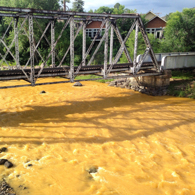
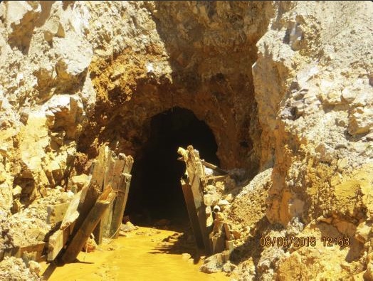
The Animas flows orange through Durango on Aug. 7, 2015, two days after the Gold King Mine spill. (Photo by Esm Cadiente http://www.terraprojectdiaries.com)
At 11 a.m. on August 5, 2015, the icy waters of Cement Creek, just outside the scenic Colorado mountain town of Silverton, began to turn to mustard-colored sludge. By day’s end, three million gallons of acid mine drainage had poured out of the inactive, 120-year-old Gold King Mine. The tainted water coursed downstream into the Animas River where it horrified kayakers in nearby Durango, prompted water treatment plants to shut off their taps, and ignited alarming front-page photos in newspapers nationwide. Within four days, the surface water had cleared and, according to EPA measurements, returned to pre-spill levels of toxic metals. But the conversation started by the Gold King blowout had only just begun.
“This was a wake-up call,” says Linda Figueroa, a Mines professor of civil and environmental engineering who studies mine remediation techniques. “It lit a fire under the abandoned mine lands community, reminded the public that this is an issue, and prompted people to put it back on the front burner.”
As industry and government agencies grapple with what to do about the estimated half-million abandoned mines nationwide, and as the state looks more closely at how to address hundreds of legacy mines fouling thousands of miles of Colorado streams, Mines—with its multi-disciplinary expertise and collaborative relationship with industry and government—is poised to play a key role.
“Our primary objective is to build knowledge, not make money, so we can give problems longer-term attention at lower cost while educating the workforce of the future,” says Priscilla Nelson, head of the Department of Mining Engineering. Already, the school has a long history of supporting research that has advanced the way mines are operated and reclaimed. And with a growing focus on the environmental and humanitarian aspects of mining, the school hopes to cultivate a new generation of miners who see themselves as “stewards of the earth’s resources,” Nelson says.
As a neutral party, Mines also hopes to facilitate a stakeholder-wide conversation about what happens next. “What do we know and what do we not know? What new technologies need to be developed?” asks Nelson, who hopes to host a symposium on the subject this year. “Let’s sit down and talk about it.”
Mining, Then and Now
Pennsylvania Mine Upper Peru Creek Basin
While much media attention has been paid to the number of abandoned, historic mines that riddle hillsides across the West, one positive development is often overlooked: Industry practices have changed dramatically since those mines were built. “There really is no comparison,” says Ronald Cohen, a Mines professor of civil and environmental engineering who has studied the history of Western mining. “The demands on industry are so much greater than they were back then.”
As early as 1870, a few vague guidelines existed for mine operators, but there was no agency to enforce them and no political will to strengthen them. Even in the mid-20th century, many Western companies still “viewed gravity as their friend,” says Cohen. They dumped their waste downstream while operating, and when it was time to close up shop, they left their tailings and rock piles behind and walked away.
“It’s not as if they were devils out to destroy the environment,” Cohen says, recalling a conversation with an old-time miner. “They felt they were supporting the economic development of their country and, during World War I and II, supporting the war effort. They thought they were doing something very positive.”
With the 1970 passage of the National Environmental Protection Act and the 1972 passage of the Clean Water Act (which regulates pollutant discharges into U.S. waters), things began to change. But even before those laws fully went into effect, a few forward-thinking companies were making
environmental sustainability a priority.
As it prepared to open the Henderson Mine near Empire, Colorado, in 1975, AMAX Inc. worked with Mines ecology professor Beatrice Willard to select a site that would be the least visible to tourists on their way to Winter Park to ski and have minimal impact on the Clear Creek Watershed. Instead of placing the tailings next to the mine, as was common practice, AMAX went so far as to build a nine-mile underground tunnel from the mine to the nearby Williams Fork Valley, where waste products could be disposed of with the least impact on the environment.
Gold King Mine circa 1899 via The Silverton Standard
“They were 30 years ahead of their time,” says Bill Cobb ’81, MS ’89 who, as one of Willard’s students, visited the Henderson Mine frequently and had test plots for one of his classes at the site. Cobb is now vice president of environmental affairs and sustainable development for Freeport-McMoRan, which owns the Henderson Mine.
Today, a company wanting to develop a brand new, or greenfield, mine in the United States can expect to spend a decade and tens of millions of dollars navigating the regulatory process. In order to get their needed government permits, mine operators must thoroughly assess the potential impact they’ll have on air and water, design systems for mitigating these impacts, develop a detailed closure plan (including land revegetation), and put up millions of dollars of financial assurance that they will be able to pay for that plan when the time comes.
Even resurrecting a shuttered mine is a colossal undertaking. When Freeport-McMoRan reopened the Climax Mine near Leadville, Colorado, in 2011, it spent $250 million on a state-of-the-art water treatment plant. The multinational company also invests in equipment made with durable, cutting edge materials throughout its supply-chain and recycles machinery when it breaks, says Michael Kendrick ’84, president of the Climax Molybdenum Company, a subsidiary of Freeport. “At Freeport, we have not purchased a new piece of haulage mining equipment in the world since 2008. As trucks wear out, we rebuild them; we don’t buy new ones,” he says. “Not only does that have tremendous financial benefit, but big picture, it’s also good for the environment.”
Heightened attention to sustainability, combined with tougher regulations, means the mining industry footprint of the future can be far lighter than it was in the past. “Going forward, we should not end up with a legacy of even more problems” (from newer mines), says Bruce Stover, director of inactive and abandoned mine programs for the Colorado Division of Reclamation, Mining and Safety (DRMS).
That said, there is still a big mess to clean up.
A Challenging Clean-up
These images show the London Mine in Park County, Colorado, before and after reclamation efforts, made possible with Freeport-McMoRan funds. (Credit: Colorado Division of Reclamation, Mining and Safety)
In the early 1980s, state surveys pegged the number of legacy “hazardous mine features”—such as mine shafts and openings—at 23,000 across Colorado. (Stover suspects that number could be up to 30 percent higher.) Thus far, the state has safeguarded 9,700 of these features. Meanwhile, about 500 inactive Colorado mines are currently causing “measurable degradation” to stream water quality. In some areas, that degradation results from storm water flowing through waste piles and tailings. To address that, DRMS sometimes removes or buries waste piles.
But in 230 cases, contaminated water flows directly from underground mine tunnels. Of these, 47 are already being addressed with active treatment efforts (such as water treatment facilities and storage ponds), and 35 are being remediated in some way, Stover says. The other 148 are “still out there draining” into state waterways. But installing a water treatment plant at all of them is impossible. “It costs millions of dollars to build one, and then you have to pay to operate and maintain it until the sun burns out,” says Stover. Alternative technologies are critically needed, and that’s where Mines comes in.
As far back as the 1980s, Mines researchers have been exploring the idea of putting resident microbes to work to help chew up and detoxify waste at legacy mine sites. Today, pilot microbial bioreactor projects are in place in several locations in Colorado and Arizona.
Figueroa, who designs and researches bioreactors, cautions that at this point, they wouldn’t be a good fit for sites with higher water flow rates (Gold King can discharge hundreds of gallons per minute). For those, an active treatment facility works best. But at sites with lots of land to build a microbial system on and a slow, steady flow of acid-rock drainage, bioreactors could provide a cheaper alternative that requires less maintenance. “We could make the money go farther and attack more sites,” she says.
Bioreactors aside, Figueroa envisions other ways Mines could partner with the state and industry to move the dial forward on legacy mine cleanups: Rather than relying on boots-on-the-ground surveys to locate troublesome mines, agencies could work with Mines students and researchers to devise ways to use drones, satellite imaging, or remote sensing technologies like LIDAR (Light Detecting and Ranging). Instead of focusing on surface water, stakeholders could collaborate with Mines to research how water flows across the land and through the tunnels and what changes occur en route. With that knowledge, they could devise better clean-up strategies.
“So far, most of the emphasis is on surface water. At that point, you can’t do anything but treat what’s coming out,” Figueroa says. “My first remediation strategy is not to do a treatment process at all, but to divert the water so it doesn’t come into contact with the minerals that can make water quality worse.”
A Solvable Problem
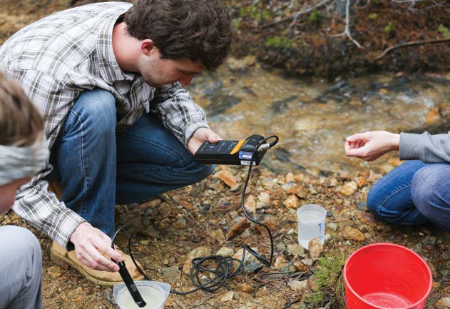
Junior environmental engineering students measure water quality parameters for their field session client, Clear Creek Watershed Foundation. (Credit: Deirdre O. Keating)
Several sources interviewed for this story say another key piece of solving Colorado’s legacy mine problem is for lawmakers to tinker with provisions in the Clean Water Act that currently keep “good Samaritans”—including mining companies, state agencies, universities, and environmental nonprofits—from trying to partially tackle the problem. In essence, if they cannot clean the water completely, they are at risk of being sued for leaving it polluted, says Stover. “Any good Samaritan, after they finish their 70 percent cleanup, could be sued by a third party under the Clean Water Act and be required to address the other 30 percent of the problem. So, if we can’t do a 100 percent cleanup, we don’t touch the water,” he says. In Pennsylvania, which has a state Good Samaritan law to protect nonprofits, more than 50 mine clean-up projects have been completed. Lawmakers are currently mulling a similar federal bill.
Money is also an issue. In recent years, several government agencies have cut their funding for legacy mine reclamation. In November, Colorado Senator Michael Bennet and others introduced a bill that would require mining companies to pay into a federal hard-rock reclamation fund reserved for cleaning up legacy mines—a fund that could amount to as much as $100 million per year. But that idea could be a hard sell at a time when, due to falling commodity prices, mining companies are taking a huge economic hit.
Mines professor Rod Eggert, who teaches natural resource economics, notes that some companies are already cutting back on capital investments as they work to “survive the current economic storm.” But he rejects the notion that lean times will dampen enthusiasm, and funding, for sustainable mining efforts overall. “Challenging times reward those who are most efficient,” he says. “Those with a long-term commitment to the industry are keeping their eye on the ball and working day in and day out to improve the way they mine and the way they interact with the community.”
Chemistry professor James Ranville (second from left) leads students in analyzing water samples from streams near mining operations during the Department of Chemistry’s summer field session. (Credit: Mark Ramirez)
As far as legacy mines go, Stover sees them as a “solvable problem” with—thanks to the Gold King Mine spill—unprecedented attention on it. “If we can’t come up with funding and resolve some of the legal issues now, we never will.”
In the meantime, some companies are already stepping up to the plate, very carefully, to help. For instance, Freeport-McMoRan contributes $500,000 per year to Colorado’s inactive mine reclamation program, helping the state to fund the removal of solid waste materials from legacy mines left behind by someone else. “We did not create these situations, and we are under no legal obligation to clean them up,” says Cobb. “But given our place in the hard-rock sector of Colorado, we feel like we need to contribute to environmental improvement of the state, and this is one thing we can do.”
The company also funds restoration projects through the nonprofit Trout Unlimited, and it supports Denver-based Environmental Learning for Kids, an education group that recently participated in a tree planting at the London Mine site above the town of Alma, where Freeport funds were used by the state to clean up the site.
Going forward, Cobb would like to see Mines students get even more involved in solving the problem of legacy mines, perhaps helping to survey abandoned sites and come up with designs to clean them up. “Who knows,” he says, “a few years down the road these students could be running an environmental group for a mining company.”
Click here to go to the US Drought Monitor website. Here’s an excerpt:
Summary
A strong upper-level low pressure system moved through the central and eastern United States during the week. In the Rocky Mountains, wet snow was recorded; on the Plains and eastward, many areas had rain. The greatest amounts were over east Texas, eastern Oklahoma, Arkansas and into the Ohio River Valley, where up to 5 inches of rain was measured at several locations. As the system tracked east, areas of the Mid-Atlantic to southern New England recorded 2-3 inches of rain, with locally greater amounts. During this time, much of the West, the northern Plains, much of the Southeast, the upper Midwest, and northern New England remained dry. Those areas that received the precipitation were also cooler than normal for the week, with departures of up to 12 degrees below normal over the High Plains and Rocky Mountains. Warmer than normal temperatures were recorded over much of the Pacific Northwest and the Southeast…
High Plains and South
Dryness continued over much of North Dakota, but no additional degradations were made this week. It was a wet week over much of South Dakota, Nebraska, Kansas, Oklahoma, and the Texas Panhandle. Cooler than normal conditions and slow-moving rain events allowed for improvements in the region. A full category improvement was made to the moderate drought and abnormally dry conditions for much of Nebraska, Kansas, Colorado and central Arkansas. Improvements were made in Oklahoma, where most areas saw a full category improvement and severe drought was eliminated. Much of the Texas Panhandle also had a full category improvement. Abnormally dry conditions were expanded slightly in west Texas and several areas of Texas were identified as areas to watch in the next several weeks for degradation if rains don’t materialize…
West
As the storm that impacted much of the eastern half of the United States formed in the Four Corners region, it brought widespread precipitation over much of eastern Nevada, Utah, Colorado, and Wyoming. Abnormally dry conditions were improved over eastern Nevada and Utah this week. A reanalysis of the data available in northwest Utah allowed for an improvement to the conditions there by a full category as well. Abnormally dry conditions were improved upon in southern Wyoming as well as northeastern New Mexico. Dryness returned to portions of the Pacific Northwest over the last several weeks, and this allowed for abnormally dry conditions to be introduced over central and northeast Oregon. In California, some moderate drought was removed in the northern portion of the state…
Looking Ahead
Over the next 5-7 days, temperatures are expected to be above normal over the eastern half of the United States with departures of 6-9 degrees above normal over the Southeast. The Pacific Northwest and northern Rocky Mountains also should see above-normal temperatures with departures of up to 12 degrees above normal. Cooler than normal temperatures are projected over the central Rocky Mountains into the Southwest with departures of 3-6 degrees below normal. Another active week appears likely as several storm systems develop over the West and eject out onto the Plains and move into the Northeast. Precipitation amounts are forecast to be greatest over the northern Rocky Mountains with amounts up to 5 inches over Wyoming. On the Plains, up to 3 inches are projected in portions of Missouri and east Texas while amounts of over 3 inches are expected in portions of the Mid-Atlantic. Most of the Great Basin, New England, and the Florida peninsula are forecast to receive widespread precipitation as well.
The 6-10 day outlooks show that the chances for above-normal temperatures are greatest over the East Coast, West Coast, and Great Basin as well as Alaska, while the best chances for below-normal temperatures will be over the northern and southern Plains. Forecasts show that the best chances for above-normal precipitation will be from the central and southern Plains to the East Coast. Chances for below-normal precipitation are best over the upper Midwest and Pacific Northwest.
A documentary screening about the Dolores River was followed by a lively forum about the issue of low flows below McPhee Dam.
“River of Sorrows” was commissioned by the Dolores River Boating Advocates to highlight the plight of the Lower Dolores River.
The new film, which is for sale on the DRBA website for $10, had several showings April 30 at the Sunflower Theatre.
A panel answered questions from a moderator and from the audience. The panel included Josh Munson of the DRBA; Mike Preston, general manager of the Dolores Water Conservancy District; Eric White of the Ute Mountain Farm and Ranch; Mike Japhet, a retired aquatic biologist with the Colorado Parks and Wildlife; and Amber Clark, of the Dolores River Dialogue.
What are the major challenges facing the Dolores River and what are the solutions for addressing those challenges?
Munson said the challenge is for people to see there are beneficial uses to Dolores River water other than just farming, such as for fishery health and boating. Changing the water rights system to allow individuals to sell or lease their water allocation so it stays in the river is one solution.
“Other uses helps to diversify the economy,” he said.
Preston said a major challenge is managing the reservoir in drought conditions. He said the goal is maximizing efficiencies in order to improve carryover in the reservoir year to year.
“High storage lifts all boats, including for recreation,” he said.
White said the film missed the compromises the Ute Mountain Ute tribe has made regarding water rights.
“Our allocation has dropped,” he said. “The tribe has fought for our water rights for a long time.”
Japhet said low flows below the dam are threatening three native fish: the flannelhead sucker, bluehead sucker, and roundtail chub.
“They have been declining precipitously,” he said.
Japhet called for more flexibility in how water reserved for fish and wildlife is managed out of McPhee. For example, 850 acre-feet diverted to the Simon Draw wetlands could be used to augment low flows on the Lower Dolores to help fish.
Clark said the big picture solution need to be collaborative and local, “or somebody from outside will find a solution for us.”
The group revealed the difficulty in finding a compromise that improves the downstream fishery and recreation boating but does not threaten the local agricultural economy.
“Use if or lose it water doctrine is a waste of water resources for farmers and conservationists,” Munson said. “The system does not allow for an individual to lease their water” for instream purposes.
Preston pointed out that in the last eight years, there has been four years where there was a release from the dam. The last one was in 2011, and this year a spill is uncertain.
“We are four for four. When we have excess water we release for boating and the fishery,” he said.
Japhet said the “elephant in the room” is if one of the three native fish species is petitioned for listing on the endangered species list.
“It would cause the U.S. Fish and Wildlife to take a very close look at what is going on with the water and fish resource,” he said. “The best solution is to be proactive and work something out locally to avoid a federal mandate telling us what to do.”
An audience member asked if the river itself has a right to water. Preston said the state instream flow program designates minimum flows for the river, including a 900 cfs below the confluence with the San Miguel. Below the dam the instream flow designation is 78 cfs.
“The river has a right to water, the fact that it was once wild should stay in people’s minds,” Munson replied. “The place itself has a beneficial use for fish, birds, otters. It’s recreation provides a way to make a living.”
Betty Ann Kohlner expressed concerns about McPhee water being used for hydraulic fracturing used for drilling natural gas.
Preston said about 4,000 acre-feet is available in McPhee for municipal and industrial purposes, including for fracking. But, he said, There has been limited use of the water for that purpose.
“If you can lease water to frack, why can’t water be leased for recreation and fish needs downstream from willing owners?” responded one man. “There is a contradiction in how we apply our understanding of how we should use water.”
Don Schwindt, of the DWCD board, pointed out that the Dolores River is part of the Colorado River compact that divides the state’s river water with several downstream states.
“Two thirds of the state’s water is required to leave by compact, and as it leaves it is available in the streams,” he said. “That two-thirds is more dominate than agricultural use.”
The major water bodies around Summit County and throughout most of the state are in strong shape after a slightly above-average winter season. However, the region is far from out of the woods on the matter of water in the West.
That was the thrust of speakers at Summit’s 23rd annual State of the River meeting on Wednesday evening, May 4 at the Silverthorne Pavilion — the first of six such meetings along the Colorado River Basin. With the Western Slope encompassing an average of 28 percent of the state’s water and spanning 15 counties, including Summit, this meeting of water wonks often sets the tone on consumption strategy and planning for rest of the year.
“There are no passengers on Spaceship Earth,” Troy Wineland, Summit County’s water commissioner, told the congested room, “there are only crewmembers. We’re all in this together.”
Wineland stressed that despite snowpack totals currently at about 115 percent of average above Dillon Reservoir — and with peak flows still to come around the first or second week of June once meltoff takes hold — circumstances are not as favorable. Other states in the country that also primarily rely on the Colorado River remain at near-critical shortages.
“While things are nice and rosy and wet and looking great here in the county,” he said, “you look throughout the entire Colorado river basin … not quite as rosy. The Lower Basin states right now are facing some very serious problems with access to water and need.”
[…]
WATER WAYS
Both Wineland and Denver Water’s Bob Steger were sure to discuss the present levels at Lake Powell during their respective presentations. Each noted how vital the resource is to every state along the Colorado Basin, even though water has already passed by many of them to arrive to Powell.
Aside from Powell functioning as the chief water supply for drinking, crop irrigation and recreation for 30-to-40 million residents in the region, the Glen Canyon Dam there also provides hydroelectric power. Besides contractual obligations of an annual average of 7.5 million acre-feet at Powell through that basin compact, of course, when water there gets below necessary levels, that has an impact back up to the Upper Basin states with increased electrical bills…
“(Lake Powell) is our bank account against accounts payable to the Lower Basin states,” re-iterated Wineland. “We’re probably within 20 feet of the critical threshold, at which point, Arizona and Nevada are going to have to make some hard decisions and really cut back on their water use.”
CHAMPIONING CONSERVATION
Despite the challenges even in what seems a healthy water year locally, all hope is not lost. The overall tenor of the meeting was mostly positive, with emphasis on how collaborative efforts across Colorado, as well as through such multi-state interdependence and agreements, proper attention on this limited resource is increasing.
Steger, Denver Water’s manager of raw water supply, brought encouraging news that the water from snowpack averages just a couple days ago are not only well above both the 20-year average on Dillon Reservoir (14.6 inches), but also ahead of 2015 (16.5 inches) as well. Current measures are 19.5 inches from this winter’s snowfalls.
On top of that, snowpacks on the South Platte River are also above normal for this time of year. That means Denver Water can most likely avoid pulling much water from Dillon Reservoir through one of its primary transmountain water diversion, Roberts Tunnel, this season for the South Platte and Denver’s consumption needs.
In fact, if that happens, that will continue a beneficial trend where 2014 and 2015 were actually the two lowest years within a 50-plus-year span for how much water has had to be removed from Dillon Reservoir through Roberts for the Platte and North Fork rivers.
“I attribute that partly to Mother Nature,” explained Steger to the audience, “because we’ve had good water supplies on the South Platte, but also our customers are doing a better and better job every year I think of conserving water. When our Eastern Slope supplies are good, that means we don’t have to take as much water from the Western Slope to the other side of the divide. That indirectly helps Lake Powell.”
Wineland also discussed how momentous the unveiling of Colorado’s statewide water plan — years in the making — in November is for the general conservation movement. To boot, regional endeavors like the recent $32,000 Colorado Water Conservation Board grant awarded to the Frisco-based High Country Conservation Center (HC3) for development and execution of a countywide water efficiency program are additional steps in the right direction. His parting words were of encouragement and optimism for the Colorado River Basin’s future.
“I just want to bring it back to the bigger picture,” he said. “We have leaders who are putting forth all this legislation and these cooperative efforts. But what we’re lacking are champions, and those champions, really, are you and I — everyone in this room. We need to take this legislation and work to the next level and implement these changes.”
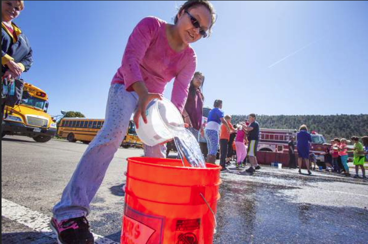
Olivia Alirez, a fifth-grade student from Ignacio Elementary School, empties buckets of water in a race known as the bucket brigade during the Children’s Water Festival on the campus of Fort Lewis College Wednesday. The 21st annual event attracted more than 750 fifth-grade students from 15 schools across Southwestern Colorado. The event is sponsored by the Southwestern Water Conservation District and is an effort to educate students about water issues, the importance of the natural resource and how they can help to protect it. Photo by Shaun Stanley/Durango Herald.
Classes rotated through a series of fun and educational activities, some of which inevitably involved water being thrown at someone.
Durango firefighters showed students the portable water tank used to supply water to fight a rural fire where there are no hydrants. Tankers shuttle water from a central supply to the portable tank, while a pumper truck pulls water from the tank to put on the fire. In the old days, community members had to use a bucket brigade, students were told.
Libby DeHaan’s class from Ignacio lined up to compete with kids from another school in a bucket brigade to see which group could be first to fill a five gallon bucket to overflowing. Not all the water ended up in the five gallon bucket. The Ignacio kids won at least two rounds.
Another session introduced kids to the intricacies of Colorado water law, which determines who gets water when there isn’t enough for everyone to have all they want. Presenters were water commissioners Marty Robbins, who oversees water from McPhee Reservoir on the Dolores River, Jeff Titus who oversees water from the Animas River, and Tom Fiddler who is in charge of water from the Florida River. They are the front line enforcers of Colorado’s priority system, “first in time, first in right.”
Students from Ryan Blundell’s class in Bayfield gathered around a table top three dimensional landscape with a reservoir at the top end, several little stream channels, and markers showing senior and junior water rights with their priority dates.
Robbins asked students if they know where their water comes from, for household use or irrigation, and how it gets to them. He asked them to describe the water cycle and then led into the priority system. He stressed that water is a private property right. “Today everyone but the La Plata River has plenty of water,” he said. “Everybody is happy. What happens when the snow goes away?”
The water commissioners opened or closed tiny barriers on the mock landscape to shut off junior water rights in favor of senior rights. There is a way for those with junior rights to keep getting water, by having storage rights in a reservoir, they said. Reservoirs hold water for use later in the year when stream flows drop. A reservoir is man-made, while a lake is natural.
Titus advised that Emerald Lake above Vallecito is one of the largest natural lakes in Colorado. He said the oldest ditch in Colorado that’s still in use is the People’s Ditch on the Culebra River in the San Luis Valley. It dates from 1852 (Colorado became a state in 1876) and was constructed by Spanish settlers.
What happens if dams aren’t properly inspected and maintained, Robbins asked. The dam could break and all your houses below get wet, he said, splashing water across the tabletop landscape and students.
Students learned about a quantity of water called an acre foot. That is one acre, about the size of a football field, covered with water one foot deep. Vallecito holds 125,000 AF.
Titus said an average household uses around 100,000 AF per year, or about half that with no outside watering. People who have to haul water use much less, he said. Water is used and re-used as it flows through Bayfield and Ignacio to Navajo Reservoir and the San Juan River to join the Colorado River in Lake Powell, then to Lake Mead, then south to Mexico.
The 21st annual Children’s Water Festival attracted more than 750 fifth-graders from 15 schools across Southwest Colorado to Fort Lewis College on Wednesday.
Sponsored by the Southwestern Water Conservation District, the event aims to educate the students about water issues, the importance of the natural resource and how they can help protect it.
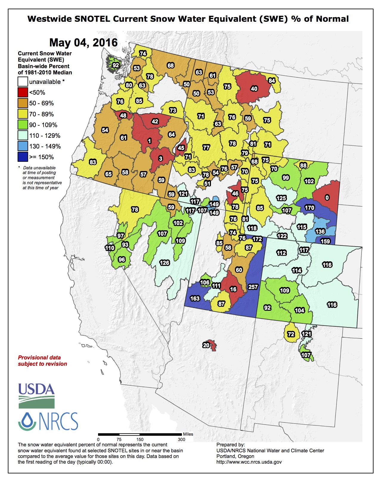
Colorado’s snowpack conditions are above average heading into the warmer months of the year after a wet April and end of March.
All but one of Colorado’s snowpack basins are above 100 percent of the historic average, and as of Monday, the state was at 101 percent.
The river basins that affect northern Colorado, the Upper Colorado and South Platte, are at 114 and 116 percent of the average, respectively. Both jumped 12 percentage points from their levels at the beginning of April.
March and April snows are ideal for building snowpack, because they have high moisture content, and wet, snowy springs are key for good water years, said Northern Water’s Brian Werner in February.
Reservoir storage for the state also is above the historic average at 113 percent. The Upper Colorado River Basin is at 115 percent and the South Platte River Basin is at 107 percent.
As of the end of April, the state was above average in total snowfall, according to Kyle Fredin, a meteorologist at the National Weather Service in Boulder. The official measuring center at Denver International Airport showed a total of 72.8 inches this season, 25 percent more than an average year, and Greeley got 43.6 inches, about 3 inches more than normal.
Though both the snowfall and snowpack are above average, Fredin said they aren’t excessive.
“We’re within what we typically see,” he said.
With temperatures expected to hit the 80s by the end of the week, the focus for meteorologists is shifting to monitoring rates of melting snow. Ideally, the mountain snowpack will melt and runoff at a controlled rate, but Fredin said the National Weather Service will watch for higher temperatures in the mountains and fast melting rates. If flooding occurs, it typically happens in early June.
“We’re about a month away from that,” Fredin said. “Time is on our side in that regard.”
Once a little-known hangout for locals, Guffey Gorge, nicknamed Paradise Cove, has become such a sought-after taste of the tropics in landlocked Colorado that big changes are afoot.
The Bureau of Land Management wants to turn the remote swimming hole in Park County into a legitimate recreational attraction.
Paradise Cove has remained a largely unmonitored, carefree summer indulgence, where the adventurous dive from tall cliffs – up to 100 feet high – into a small deep pool, to the awe of onlookers.
“It’s a well-known spot to go to swim and lounge around,” said Kym Trutwin, a recent Pikes Peak Community College graduate who grew up in Teller County. “A big part of the appeal is that it’s completely natural and tucked away in the woods. It’s a peaceful area – a public space that gives you a sense of privacy.”
In the last 15 years, more people have been seeking out Paradise Cove, located off County Road 102 outside the small town of Guffey. On average, 18,000 people now visit the site each year, with usage peaking in July with more than 6,000 visitors. Most are Front Range urbanites between the ages of 16 and 30, BLM research says.
But empty beer bottles, fast food wrappers and other trash, along with human waste and dog doo, have tarnished the hidden gem.
The increased usage has adversely impacted the environment and raised safety concerns, according to a proposed BLM business plan for the area.
As a result, BLM wants to build a designated parking lot with easier access to the trailhead, add permanent restrooms, charge a $6 per vehicle daily admittance fee, ban alcohol, require dogs to be leashed, provide trash receptacles, install picnic tables and increase policing of the area.
Those steps would reduce health risks to downstream water users, lessen soil erosion and damage to vegetation and pay for the improvements, BLM officials say.
“If a comment is substantive and something that should be included or changed in the business plan, we will include it in the document,” said BLM spokesman Kyle Sullivan.
The Front Range Resource Advisory Council will review the final business plan and decide whether to approve it, Sullivan said. Construction of the parking area and installation of a vault toilet, bear-proof trash receptacle and picnic table would be done during next year’s off-season, with the fee starting May 15, 2017. The fee would be charged May 15 through Sept. 30 each year and raise an estimated annual revenue of $16,000 to $26,000.
‘It takes your breath away’
After hiking half a mile across Fourmile Creek and through a lush valley, the sound that something out of the ordinary lies ahead reaches trekkers before the sight of the scenic canyon.
Loud slaps can be heard while hiking an incline that gives way to the cove. The noise is the bodies of divers hitting the water.
Entering the waterfall-fed pool is the worst part of leaping off the granite cliffs that have outcroppings of various heights, some say.
“It’s freezing” is the most common complaint about the water, even in the heat of the summer.
“It takes your breath away,” one diver said last August, shivering as she emerged from the pool.
A shallow end accommodates waders, and large boulders provide viewpoints from which to watch the cliff jumping. Signs warn of the dangers of diving but don’t seem to deter many of the brave or foolhardy.
For some, the apparent impending changes will mark the end of an era, like the death of the drive-in.
“It’s pretty natural and mostly untouched,” Trutwin said, adding that she hopes nothing will detract from the area’s beauty.
Erik Kjelland, who works in the health care industry in Teller County, said he isn’t in favor of any changes.
“I think it should be left the way it is, as a beautiful natural resource and recreation area,” he said. “It’s a gorgeous place to cool your feet.”
The BLM’s Royal Gorge Field Office has been working for more than a decade to address “resource issues” at Paradise Cove, the agency’s Sullivan said.
Restrictions aimed at reducing impacts to the environment started in 2005, with the banning of motorized vehicles, glass containers and campfires, and limiting usage to daylight hours and prohibiting overnight camping.
Porta-potties have been added in recent years, along with designated parking.
The most recent environmental assessment started in 2013 and was finished last year. It included input from cove-goers, the general public and the local community.
The 80-acre site is surrounded by private land. Locals want stricter regulations because they say Paradise Cove has become a popular destination for underage drinking and partying. Users are often loud and noisy, leave their trash behind, disrespect nearby property owners and get drunk or use drugs, creating a potential for safety issues, according to public comments previously made.
Trutwin said commercializing the area might make it even more dangerous, though.
“It might make it too crowded in the summer on warm days when people want to go there the most,” she said. “The more crowded that space gets, the more dangerous the area around the water might become.”
Among the alternatives considered were closing the area entirely or banning diving. Neither of those options are suggested in the draft proposal.
Click here to read the latest board meeting summary from the Colorado River Water Conservation District. Here’s an excerpt:
The Colorado River District has found that there is no compelling safety reason to proceed with remediation of Ritschard Dam at Wolford Mountain Reservoir in Grand County, now or in the foreseeable future.
This conclusion comes after exhaustve study of the settlement and a failure-risk assessment of the rock-fill, clay-core dam put into service in 1995. The River District’s consulting engineers and a separate Consultant Review Board it commissioned, together with the State of Colorado Dam Safety Branch, have concluded that the dam remains safe.
Snowmass Village water district residents approved a tax increase to pay for a new wastewater treatment plant Tuesday.
Four hundred twenty-eight residents voted in favor of the mill levy increase that will cover the almost $20 million cost of the project, according to unofficial results from Tuesday’s election.
The increase means property owners in the district will pay an additional $1.89 per $100,000 of assessed property value each month. The water district is required to overhaul its wastewater treatment facility in order to comply with new standards handed down by the Environmental Protection Agency.
Sixty-nine residents voted against ballot measure 5A. All residents of the district, including rental tenants, who are registered to vote could participate in the election as well as any property owners or their spouses who are registered to vote in the state of Colorado.
Snowmass Villagers also elected Shawn Gleason and David Spence to fill two vacancies on the district’s board.
The latest research focused on helping communities develop resilient water supplies will be presented at the 20th Annual WateReuse Research Conference in Denver, CO on May 22-24, 2016. The Research Conference provides a unique opportunity for water professionals and researchers to interact, network, and discuss current research and future trends. This solutions focused event will provide water professionals and industry with tools to address water scarcity and sustainability challenges.
From the Utah Division of Wildlife via The Deseret News:
For the first time since work to recover bonytail started in the 1980s, they’re raising their own young in the wild, officials with the Utah Division of Wildlife Resources say.
Bonytail are the rarest of the endangered fish that live in the upper Colorado River system.
“This finding represents a major step forward in recovering the species and ultimately getting it removed from the federal endangered species list,” Krissy Wilson, native aquatic species coordinator for the DWR, said in a statement.
In spring 2015, researchers with the DWR found adult bonytail in Stewart Lake near Jensen. The lake is a managed floodplain that’s connected to the Green River. When the floodplain was later drained in the fall, the researchers found 19 young-of-the-year native chub.
As the researchers analyzed their data, they expected the young-of-the-year chubs to be roundtail chubs. But they realized the size of the chubs did not fit with the timing of when the roundtail chubs would have spawned.
“That’s when the researchers got excited,” Wilson said. “Were the specimens they were examining the first documented evidence of bonytail reproducing in the wild?”
The researchers sent the preserved specimens to the Larval Fish Laboratory at Colorado State University. There, scale and body measurement analysis was done. Next, the specimens were sent for genetic testing. Both analyses confirmed what the UDWR researchers were hoping: the specimens were bonytail.
Wilson says the last wild adult bonytail were collected in the late 1990s. Since then, bonytail have been reared at the DWR’s Wahweap State Fish Hatchery at Lake Powell. The bonytail are reared to 12 inches long before being stocked in the upper Colorado River system.
Wilson says for the past four years, the Upper Colorado River Endangered Fish Recovery Program and its partner, the Bureau of Reclamation, have coordinated spring releases from Flaming Gorge Dam to connect floodplain habitats along the Green River near Jensen. Connecting the floodplains provides important nursery habitat for the endangered Colorado River fish.
“So far,” Wilson says, “razorback sucker is the species that’s benefitted most from the releases. It’s exciting to see that the releases are also benefitting bonytail.”
Along with bonytail and razorback sucker, humpback chub and Colorado pikeminnow are the four fish the Upper Colorado River Endangered Fish Recovery Program is working to recover. More information about the program and its work is available at coloradoriverrecovery.org.
Upper Colorado River Endangered Fish Recovery Program
For decades, the West’s big reservoirs were like a security blanket, says Anne Castle, the former assistant secretary for water and science at the Interior Department. But the blanket is wearing thin. Under normal conditions, Lake Mead loses 1.2 million acre-feet of water every year to evaporation and deliveries to the Lower Basin states plus Mexico, which amounts to a 12-foot drop. Previously, extra deliveries of water from Lake Powell offset that deficit, but after 16 years of drought and increased water use in the Upper Basin, those extra deliveries are no longer a safe bet.
“There’s a growing recognition that even these huge reservoirs aren’t sufficient to keep the water supply sustainable anymore,” says Castle.
For the three Lower Basin states — California, Arizona and Nevada — that rely heavily on Lake Mead, the situation is particularly urgent. For the last several years, Mead has hovered around 1,075 feet above sea level, the point at which harsh water rationing measures kicks in. And if conditions in the reservoir continue to worsen, the Interior Department could even take control of water allocation from Lake Mead.
So, with the threat of a federal takeover looming, last summer, water policy leaders in the Lower Basin states, along with the Bureau of Reclamation, the reservoir’s operator, began meeting to discuss ways they can jointly boost water levels in Lake Mead. Some of the details are now available and indicate that all three states are now willing to accept additional water cuts from the reservoir on top of the cuts that they previously agreed to make in 2007.
Those measures follow a set of federal guidelines adopted nine years ago to manage water deliveries from Lake Mead given the likelihood of future shortages. The guidelines established a series of thresholds for the reservoir’s water levels that would trigger increasingly severe cutbacks for the Lower Basin states. At the time they were negotiated, few people anticipated that the drought would last as long as it has, but as Lake Mead inched closer to the critical 1,075 mark, water managers in the Lower Basin realized that the existing guidelines were not enough to prevent an eventual shortage.
While the terms of the new agreement between California, Arizona, and Nevada are still being negotiated, a few details have emerged. For starters, the Bureau of Reclamation has pledged to cut 100,000 acre-feet annually through efficiency measures such as lining irrigation canals to prevent seepage, or possibly by re-opening the long-shuttered Yuma Desalination Plant.
The three states’ willingness to collectively ration their water use would have been unthinkable just a few decades ago when states fought each other in court to win as much water from the Colorado River. The cooperation is a nod to how new climate realities are re-shaping old water politics in the West. Take California, for instance. Legally, the state could hold onto every drop until Lake Mead is nearly down to mud, since the 1968 law that authorized the Central Arizona Project’s construction gave California highest priority water rights to the Colorado River. But at that point, says Castle, they’re just as impacted as everyone else.
Other collaborative agreements to reduce the strain on the Colorado River include a 2014 Memorandum of Understanding between the big water providers in the Lower Basin states, the Bureau of Reclamation, and the Central Arizona Project, pledging “best efforts” to conserve 40,000 acre feet in Lake Mead. In 2014, major municipal water providers in Arizona, California, Nevada and Colorado also agreed to fund new water conservation projects through a pilot initiative called the Colorado River System Conservation program.
For the Lower Basin especially, the negotiations are necessary to avoid the potential federal takeover, says Tom Buschatzke, the director of the Arizona Department of Water Resources. Although the Secretary of the Interior, Sally Jewell, has not voiced any immediate plans to that effect, in the past, she has made public statements on the matter.
For Buschatzke, the threat is clear: “She’ll take action if we don’t collaborate,” he says.
Here are the cuts states could face:
Arizona would lose 512,000 acre-feet of its total 2.8 million acre-feet per year allotment if Lake Mead dips below the 1,075 feet threshold. That’s 192,000 acre-feet more than the 320,000 acre-feet it had previously agreed to cut under the 2007 guidelines. Further cuts occur if the reservoir continues to drop. In another unprecedented move, Arizona water officials are talking of trying to spread cuts across all sectors of the state’s economy that rely on CAP water for drinking and irrigation — cities, farms, industries, Indian tribes and others — instead of letting only farmers take the brunt of the cuts, as dictated by their junior water rights.
California
Thanks to the 1968 law that authorized CAP’s construction, California’s 4.4 million acre feet allotment is shielded from most of the cuts should a shortage on Lake Mead be declared. But as part of the new negotiations, the state has volunteered to cut its water use from Lake Mead by 200,000 acre feet if the reservoir’s levels fall below 1,045 feet and up to 350,000 acre-feet if levels sink to 1,030 feet.
Nevada
The state with the smallest allotment of Colorado River water, Nevada would take a much smaller share of the cuts — 8,000 acre-feet if Mead drops below 1,045 feet and 10,000 acre-feet after that — because it has the right to only 300,000 acre-feet.
A “get well soon” balloon floats in the contaminated waters of the Animas River flowing through Durango on Monday afternoon August 10, 2015 — photo The Durango Herald, Shane Benjamin
An additional $600,000 has been set aside by the Environmental Protection Agency for a real-time warning system that will be installed in the Animas and San Juan rivers that would alert local governments to pollution.
The EPA had set aside $2 million for water and sediment monitoring, but that was found to be inadequate, Shaun McGrath, the Region 8 administrator, told the Durango City Council on Tuesday. A total of $465,000 was allocated to the state of Colorado.
States and tribes will use the additional funds for a system they started collaborating on in February, McGrath said.
There is no timeline for the additional warning system to be installed, he said.
Sen. Michael Bennet, Sen. Corey Gardner and U.S. Rep. Scott Tipton have pushed for additional funding to provide better data to communities along the Animas and San Juan watersheds, according to a news release.
“We are glad the EPA has heeded these concerns, and we’ll continue to work to make sure it meets its commitment to fully reimburse the community for expenses related to cleanup and recovery from the spill,” Bennet said, in the release.
Councilor Dean Brookie lauded the additional funding.
“It will allow for a more robust and state-of-the-art system then was previously achievable,” said Councilor Dean Brookie.
In the event of another acidic mine wastewater spill like the 3 million gallons released by the EPA on Aug. 5, 2015, the system will ensure downstream communities wouldn’t have to wait for a person to inform them of the emergency, Brookie said.
There are 30 testing locations along the Animas, San Juan and Colorado rivers, Brookie said.
The EPA is also considering additional reimbursements to the local governments, including the city and La Plata County, McGrath said.
State, local and tribal governments have received $881,152 in reimbursements.
The city has been promised $2,471 to cover a tour city councilors took related to Superfund designation. But the city has asked for about $5.7 million in compensation over the next 15 years, which would include the amount spent on the immediate response and ongoing monitoring of river health…
The city wants to provide the EPA with all the information necessary to help fit within the federal guidelines, Durango City Manager Ron LeBlanc told McGrath.
“The city wants to work as a team with the EPA and the county,” he said.
Here’s the release from Denver Water (Stacy Chesney/Travis Thompson):
Denver Water CEO Jim Lochhead’s statement in response to Denver City Council’s ordinance to allow graywater use:
“Water conservation has been key to ensuring we meet the needs of future generations, and it’s time that as a city and state we take additional steps to embrace an integrated, sustainable approach to urban water management. Using the right quality water for the right use is a critical step in a sustainable water future for Colorado, and this step by the Denver City Council shows the kind of progressive action we need to be taking to make sure we have enough water to meet our future needs. We applaud the leadership of the city of Denver in taking this important step.”
[Scott Tietmeyer], who has been involved in a water dispute since the early 2000s, said the future of farming in northern and eastern Colorado is water, but with farmers going bankrupt to defend it, that future is getting drier. For more than a decade, Tietmeyer and other farmers in his area have fought to protect their water rights. But protecting groundwater can be a pricey endeavor.
This year, Colorado Reps. Edward Vigil, D-Fort Garland, and Don Coram, R-Montrose, introduced House Bill 1337 to address this issue. The bill would make it so no new evidence could be introduced at appeals.
The way the system is set up, at each level of appeals in a water hearing, new evidence can be presented. This makes it so farmers, ranchers and other water rights holders have to pay for new engineering, research and legal defense of new evidence at every step of the process, because either party in the lawsuit can withhold key pieces of their argument to improve the likelihood of a win after an appeal.
Sen. John Cooke, R-Greeley, planned to vote for the bill on the Senate floor because in every other kind of trial, the same evidence has to be used at an appeal that is used at an initial hearing.
The bill passed the Colorado House of Representatives 60-5, but it was killed in the Senate Judiciary Committee last week. A similar bill was killed last year as well.
The bill would have helped farmers and ranchers in situations similar to Tietmeyer’s.
Fourteen years ago, Tietmeyer and several other famers in the Upper Crow Creek River Basin were told their groundwater pumps caused or could cause surface water loss for a senior water rights holder. This complaint started a legal process that’s still going today.
Despite the first hearing ruling going in favor of Tietmeyer and the other farmers, the senior water rights holder appealed the case all the way to the Colorado Supreme Court, which ruled that Tietmeyer and the others would have to yield to the senior water rights holders if they could prove their use of the water would suffer.
That ruling was in 2006. The decade since has been filled with research and legal battles between the surface and groundwater users. Tietmeyer said the newest round of trials have escalated to the Supreme Court again.
Not every case is as draining on time or funds as Tietmeyer’s. Some take place between two farmers, or between a municipal water user and a rancher or in the most worrisome cases, a big water buyer and a farmer.
Rep. Jon Becker, R-Fort Morgan, said HB 1337 would have blocked a lot of the illegal water speculation that takes the water off of ag lands. Becker, who supported the bill in the House, said the bill was really “common sense,” and he guaranteed he is willing to carry the bill next year.
In the years since the lawsuit in the Upper Crow Creek Basin started, Tietmeyer said his family has spent close to $100,000 on the litigation. Others in the area who own more wells than he does have spent even more, he said. Tietmeyer has seen some farmers forced to choose between their water rights and bankruptcy. At least seven wells in the area have been sitting out of use for more than a decade because their owners couldn’t afford to go to trial.
Tietmeyer said defending his wells was never a question, despite the financial burden, because he needs the water to irrigate his wheat, corn and alfalfa, and to guarantee his farm has a future.
“As a farmer, we’re putting everything upfront, because we can’t afford to lose these rights,” Tietmeyer said. “When you’ve gone 11 years and no one will ever benefit from that court case, there’s something wrong.”
Directional drilling from one well site via the National Science Foundation
From the Associated Press (Dan Elliott) via the Fort Collins Coloradoan:
Colorado’s battle over who should regulate fracking — and how much — now shifts to the November election after the state Supreme Court overturned attempts by local governments to impose their own rules.
The court ruled Monday that a ban on fracking in Longmont and a five-year moratorium in Fort Collins are invalid because they conflict with state law. State officials and the industry argued the state has the primary authority to regulate energy, not local governments.
It wasn’t the end of the debate, however. Coloradans face a loud and fierce campaign over fracking this fall if activists succeed in getting any constitutional amendments on the ballot to restrict oil and gas drilling or give local governments the authority to do so.
“We’re taking them as a serious threat to responsible oil and gas development in the state of Colorado,” said Karen Crummy, a spokeswoman for an industry-backed group called Protecting Colorado’s Environment, Economy and Energy Independence.
“We consider all of these measures to be a ban on fracking,” Crummy said. “We’re going to fight.”
Backers of the proposed constitutional amendments also vow a fight, saying Monday’s ruling injects a sense of urgency into their cause.
“It can only help us because it shows that communities don’t have many rights right now when industry wants to drill,” said Tricia Olson of Yes for Health and Safety over Fracking, which hopes to get two measures on the ballot.
Fracking, or hydraulic fracturing, has long been a contentious issue in Colorado, the nation’s No. 7 energy-producing state. Fracking injects a high-pressure mix of water, sand and chemicals underground to crack open formations and make it easier to recover oil and gas.
Combined with other drilling techniques, it opened up previously inaccessible oil and gas reserves and boosted the economy, although low oil prices have led to widespread layoffs and a steep decline in drilling.
Critics worry about danger to the environment and public health from fracking spills and leaks. Others say around-the-clock noise, lights and fumes from drilling rigs make their homes unlivable as oilfields overlap with growing communities.
The industry says fracking is safe and that drilling companies take steps to minimize the disturbances.
Restrictions on fracking were proposed for Colorado’s 2014 ballot, but they were withdrawn because of fears they would lead to a huge Republican turnout and hand several close statewide races to the GOP.
Gov. John Hickenlooper promised to convene a task force to address the conflicts caused by drilling, but fracking critics were disappointed by its recommendations, and the industry said regulators went too far in implementing them.
This year, the presidential election will have a bigger impact on turnout than the fracking proposals, said Floyd Ciruli, a nonpartisan Denver pollster. But fracking could influence races in the Legislature, where Democrats have a narrow majority in the House and Republicans have a narrow edge in the Senate, he said.
“I do think that at the legislative level where relatively small shifts in turnout could be a big thing, it could be very important,” Ciruli said.
Some of the proposed constitutional amendments would clamp specific restrictions on the oil and gas industry, such as minimum distances between wells and homes. Others would grant local governments more regulatory power. Because they’re constitutional amendments, they would supersede Monday’s Supreme Court ruling.
Olson’s group and others are still gathering petitions to get their amendments on the ballot. If they succeed, they will face a well-financed campaign to defeat them.
By the end of last year, the pro-industry group, Protecting Colorado’s Environment, Economy and Energy Independence, had $746,000 on hand, according to state records.
Two groups supporting the constitutional amendments to restrict fracking reported they had less than $15,000 combined on hand this spring. Their reports covered a different period than the industry group’s.
“What we know is that industry has already been advertising nonstop,” Olson said. “What we know is they will put everything against it. But what we also know is that we have very few options left to protect Colorado’s health, safety and welfare.”
The issue does not directly impact La Plata County, where there is no ban or moratorium on oil and gas drilling activities. But it stands to guide future actions.
“The Supreme Court’s decision does not mean that the local control issue is going away,” said La Plata County Commissioner Gwen Lachelt, a Democrat. “Local governments need the ability to plan and ensure that oil and gas development occurs away from schools and neighborhoods.”
Some observers say the ruling reaffirmed local governments’ land-use authority, since it stated only that bans and moratoriums interfere with the state’s rule-making.
La Plata County in 1992 had a stake in determining that authority, when the Supreme Court upheld the county’s authority to regulate land-use impacts of oil and gas development.
In separate unanimous written rulings Monday, the Supreme Court declared a fracking ban in Longmont and a moratorium in Fort Collins illegal, stating that the voter-approved actions conflict with state law.
“This ruling sends a strong message that bans are not the way we do business in Colorado,” said Christi Zeller, executive director of the La Plata County Energy Council.
She underscored that La Plata and the Colorado Oil and Gas Conservation Commission have “robust” rules that have been re-written dozens of times over several decades.
“The reality is political decisions take away private property rights, they restrict and hinder business, and they disrupt the economy, here in La Plata County, and in other counties and cities in the state,” Zeller said.
Bruce Baizel, a Durango-based energy program director for Earthworks, called the Supreme Court’s ruling disappointing, but not surprising.
“It kind of pushes things back into the political realm in terms of initiatives,” Baizel said. “They (the Supreme Court) explicitly said it doesn’t matter if drilling or fracking negatively impacts residents, and the state has decided it’s not going to address that.”
Justice Richard L. Gabriel, who wrote the court’s opinion, said justices were not charged with weighing the economic advantages or health risks associated with fracking.
“This case … does not require us to weigh in on these differences of opinion, much less to try to resolve them,” Gabriel wrote.
Groups are readying ballot initiatives for November that run the gamut, including allowing local governments to ban fracking and increasing the distance of well setbacks.
“It makes absolute sense that it would strengthen those folks’ resolve to get a measure on the ballot,” Lachelt said of the ruling.
She co-chaired a task force that convened in 2014 to address the local control issue.
“I’ve expressed my disappointment that the task force didn’t adequately deal with the issues,” Lachelt said. “But just because we have a Supreme Court ruling doesn’t make this issue go away.”
Gov. John Hickenlooper, a Democrat who convened the task force as part of a compromise to avoid ballot initiatives at the time, defended the work of the panel.
“The work of the task force amplified the role of local governments in siting large oil and gas facilities and built a stronger connection between state and local regulators,” the governor said in a statement.
Attorney General Cynthia Coffman, a Republican, doubts the high court’s ruling will quell controversy.
“I fear today’s ruling will not end this divisive debate and instead some activists will continue to push anti-development initiatives undermining the state’s record of local cooperation on these policy issues,” Coffman said.
Lauren Petrie, regional director of Food and Water Watch – which helped with several initiatives across the state – said much of the opposition is just beginning.
“Today’s decision deals a devastating blow not just to Longmont residents, but to all Coloradans who have been stripped of a democratic process that should allow us the right to protect our health, safety and property from the impacts of this dangerous industrial activity.”
From the Fort Collins Coloradoan (Jacy Maramaduke):
The Colorado Supreme Court on Monday struck down Fort Collins’ five-year fracking moratorium, a long-awaited decision that could have statewide implications for the controversial oil and gas recovery method.
The court also ruled against Longmont’s voter-supported ban on hydraulic fracturing, the widespread practice of injecting a high-pressure mix of water, sand and chemicals underground to break open formations and recover oil and gas.
In its first judgment on local fracking bans and moratoriums, the court called both laws “invalid and unenforceable” because they’re preempted by state law.
Fort Collins voters supported the moratorium in 2013, and Longmont’s ban was voted into place in 2012. But the Colorado Oil and Gas Association sued both cities in separate cases and won in the lower courts, resulting in the bans being thrown out.
Both cities appealed the lower court’s decisions, and the state appeals court in August asked the Supreme Court to take the cases. The high court heard oral arguments for the cases in December.
ANALYSIS: What’s in Larimer County’s fracking fluid?
The Fort Collins and Longmont cases represent an ongoing debate in Colorado and beyond about whether the ultimate right to regulate the oil and gas industry should belong to states or municipalities. The city of Fort Collins spent about $191,000 on outside counsel defending the citizen-initiated moratorium in court. COGA spent about $1 million fighting the Fort Collins and Longmont laws, along with a fracking ban in Lafayette and moratorium in Broomfield.
There are currently no active wells or permit-pending wells in Fort Collins. One oilfield extends into the northern edge of Fort Collins, but it’s been at least three and a half years since a well was fracked there.
What’s next?
Fort Collins and Longmont can’t appeal the decisions to the U.S. Supreme Court because they aren’t a matter of federal law. The city of Fort Collins hasn’t yet announced its next steps, if any.
In a statement, Fort Collins city attorney Carrie Daggett said it’s “premature” to comment until the city has carefully reviewed the high court’s decision.
“These issues are complex, and we’ll thoroughly examine the decisions relative to Fort Collins and Longmont,” she said.
Citizens for a Healthy Fort Collins, which campaigned for the ballot measure that installed the moratorium, wrote in a Facebook post that the group will meet in two weeks to discuss next steps. The group had not replied to the Coloradoan’s request for more information by mid-afternoon Monday.
COGA leaders said they were pleased that the court sided with them in their view that local fracking bans and moratoriums are illegal in Colorado.
“This is not just a win for the energy industry, but for the people of Colorado who rely on affordable and dependable energy and a strong economy,” COGA President and CEO Dan Haley said in a press release. “It sends a strong message to anyone trying to drive this vital industry out of the state that those efforts will not be tolerated.”
Longmont’s City Attorney’s Office will meet in executive session with the Longmont City Council on Tuesday night to review the court ruling, according to a city press release.
Broomfield, which faced a COGA lawsuit similar to Fort Collins’ for its voter-initiated, five-year fracking moratorium, stalled the lawsuit in anticipation of the Colorado Supreme Court decision. Monday’s rulings will likely lead to the invalidation of that moratorium, along with a five-year moratorium in place in Boulder and unincorporated Boulder County.
The city of Lafayette didn’t appeal after a district court judge struck down its fracking ban in 2014.
Mixed reactions
City of Longmont
“The case did not end as the city hoped, but we respect the Supreme Court’s decision,” Longmont Mayor Dennis Coombs said in a press release. Coombs noted that Longmont’s other oil and gas regulations, including no drilling in neighborhoods, mandatory groundwater monitoring and setbacks from riparian areas remain in place.
U.S. Rep. Jared Polis, a Democrat whose district includes Fort Collins
Polis called the decision “a blow to democracy and local control” in a statement.
“Now that the law has been interpreted, it’s up to the state legislature or the people of Colorado to act to protect our neighborhoods and homes,” he said. “I look forward to continuing to help advocates in these efforts to protect our communities.”
The representative also submitted an amicus curiae brief to the court siding with Fort Collins. Through his attorney, Courtney Krause, Polis argued that Fort Collins’ moratorium was a valid land use regulation.
Colorado Rep. Mike Foote, a Democrat whose district includes Longmont
In a press release, Foote said he was disappointed about the decisions but noted that they reaffirmed local governments’ land use authority.
“Cities and counties may need to modify their approach somewhat,” Foote said, “but it’s clear that the Court has reaffirmed that local governments do have a seat at the table when it comes to oil and gas development.”
“And “in cases where local control isn’t recognized, we as legislators have the ability to step in,” he added.
Colorado Attorney General Cynthia Coffman
In a press release, Coffman said that local fracking bans “undermine the interests of the state as a whole.” But despite the court decisions, the fight might not be over yet, she said.
“Sadly, I fear today’s ruling will not end this divisive debate and instead some activists will continue to push anti-development initiatives undermining the state’s record of local cooperation on these policy issues,” she said.
Boulder County Board of Commissioners, which passed a moratorium on fracking in unincorporated areas of the county until July 2018
The high court decisions are specific to the communities named in the lawsuits, an unidentified board representative wrote in a press release, so the impact of the decisions on Boulder County will need further analysis.
“Like all other Colorado communities that regulate oil and gas development, we need to take a close look at our existing regulations before we take any action to change our stance on fracking in unincorporated Boulder County,” the release said.
Conservation Colorado
In a press release, Conservation Colorado executive director Pete Maysmith called the decisions “disappointing” and said that local governments should be able to call a timeout on drilling while they examine its impacts.
“These decisions … show that the oil and gas industry’s threats of litigation are a hammer that the industry has no qualms about wielding against local governments if they decide to engage in land use planning,” he said in the release. “In order to combat this hammer, local governments must be empowered with better tools to protect their citizens from heavy industrial drilling.”
Colorado Petroleum Council
The Colorado Petroleum Council welcomed the decisions for upholding the state’s primacy in overseeing oil and natural gas permitting and curtailing “arbitrary bans” on fracking that could cost local jobs, deprive state and local governments of tax revenue and limit access to energy resources, according to a CPC press release.
“Today’s decision protects private property rights, which are a main driver for the energy renaissance in this country,” executive director Tracee Bentley said in the release. “The U.S. was counted out as an oil and natural gas superpower, but with states like Colorado leading the way, the U.S. defied the odds to become the world’s largest producer of natural gas and a world leader in crude production.”
Advancing Colorado, a political advocacy group that supports fracking and the production of coal and natural gas, among other things
“Today’s ruling protects Colorado’s robust energy portfolio and energy independence, and sends a strong message to the deceptive anti-energy extremists,” executive director Jonathan Lockwood said in a statement. “The Colorado Supreme Court is protecting our democratic process and their ruling will help protect our health, safety and property from the attacks of dangerous special interest groups.”
This view of Moffat Treatment Plant’s corridor was taken in 1939. Photo via @DenverWater.
Click here to read the newsletter. Here’s an excerpt:
Tour a water treatment plant
Learn how water is treated by taking a FREE tour at one of Denver Water’s treatment plants:
Denver Water’s Recycling Plant treats effluent from Metro Wastewater to a nonpotable standard for industrial and irrigation uses. The facility, which opened in 2004, is the largest of its kind in Colorado. Tours are available from 1 to 3 p.m. on May 6 and Oct. 7.
Moffat Treatment Plant treats West Slope water brought through the Moffat Tunnel and Gross Reservoir for delivery into Denver Water’s distribution system. Tours are available from 1 to 3 p.m. on June 3 and Sept. 9.
Marston Treatment Plant treats South Platte River and Roberts Tunnel water for distribution throughout the metro service area. Tours are available from 1 to 3 p.m. on July 8 and Aug. 5.
Tours are limited to 25 people. Participants must be 18 or older and request a spot at least two weeks in advance.
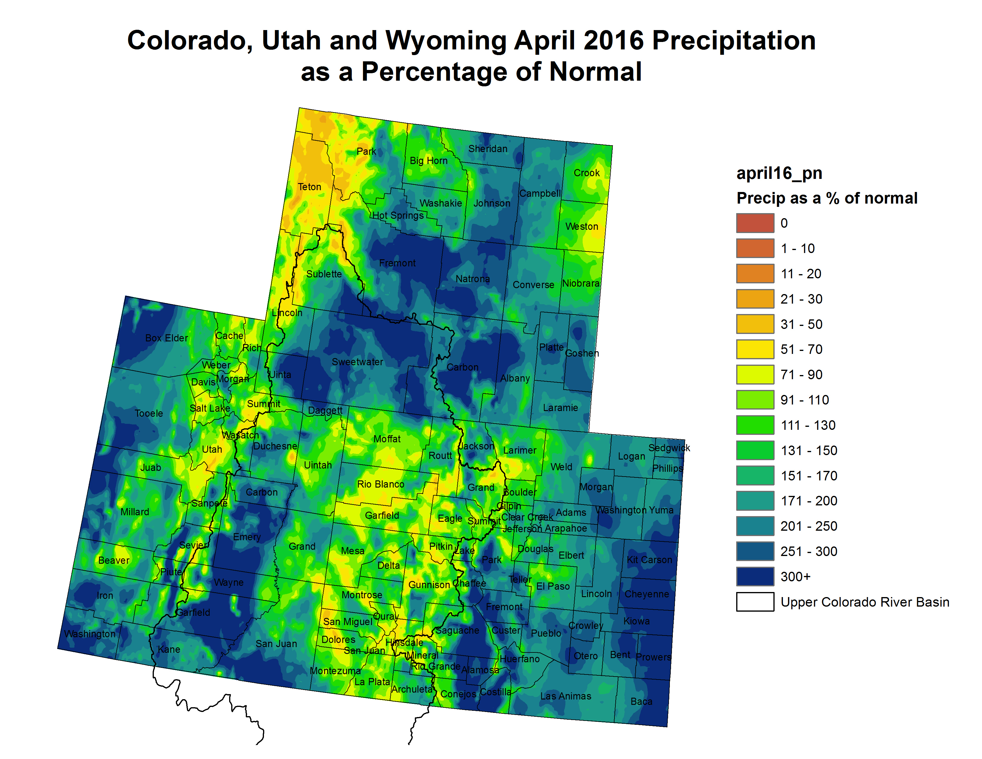
April of 2016 started out relatively warm and dry across south central and southeast Colorado. However, a cool and unsettled weather pattern then developed across the region, with slow moving weather systems moving across the state April 10th and 11th, April 14th through the 20th and April 27th through the 30th. These slow moving weather systems brought abundant widespread rain and snow to much of south central and southeast Colorado. This very benefical precipitation has helped to suppress much of the moderate to locally severe drought conditions, which had developed across the far southeastern Colorado Plains over the past several months.
For the month as a whole, near to slightly below normal normal temperatures and above to well above normal precipitation were experienced across the south central and southeast Colorado over the past month of April. The following graphics depict monthly temperature and precipitation departures from normal across the state for April of 2016.
The preliminary average temperature in Alamosa for the month of April was 41.9 degrees, which is 0.1 degrees above normal. Alamosa recorded 1.75 inches of precipitation through out the month of April. This is 1.16 inches above normal and makes April of 2016 the 3rd wettest April on record in Alamosa. This is still well behind the 3.06 inches of precipitation recorded through out April of 1942. Alamosa recorded 15.2 inches of snow through out the month of April. This is 11.6 inches above normal and makes April of 2016 the 2nd snowiest April on record in Alamosa, behind the 17 inches of snow recorded through out April of 1938.
The preliminary average temperature in Colorado Springs for the month of April was 46.7F, which is 0.2 degrees above normal. Colorado Springs recorded 2.28 inches of precipitation and 13.6 inches of snow through out the month of April, which is 0.86 inches and 8.7 inches above normal, respectively. Of note, the 2.28 inches of precipitation and 13.6 inches of snow recorded in Colorado Springs only makes April of 2016 the 20th wettest and 13th snowiest April on record.
The preliminary average temperature in Pueblo for the of month April was 52.5 degrees, which is 1.9 degrees above normal. Pueblo recorded 2.97 inches of precipitation through out the month of April. This is 1.57 inches above normal and makes April of 2016 the 10th wettest April on record in Pueblo. This, however, remains well below the 8.13 inches of precpitation recorded through out April of 1900. Pueblo also recorded 3.3 inches of snow through out the month of April, which is 0.5 inches below normal.
Looking ahead into May, in Alamosa, the average high and low temperature of 64 degrees and 29 degrees on May 1st, warm to 74 degrees and 37 degrees by the end of the month, with an average montthly temperature of 51.2 degrees. Alamosa averages 0.58 inches of precipitation and 0.9 inches of snow through out the month of May.
In Colorado Springs, the average high and low temperature of 65 degrees and 38 degrees on May 1st, warm to 74 degrees and 47 degrees by the end of the month, with an average monthly temperature of 55.9 degrees. Colorado Springs averages 2.03 inches of precipitation and 0.7 inches of snow through out the month of May.
In Pueblo, the average high and low temperature of 72 degrees and 39 degrees on May 1st, warm to 81 degrees and 49 degrees by the end of the month, with an average monthly temperature of 60.4 degrees. Pueblo averages 1.51 inches of precipitation and 0.5 inches of snow through out the month of May.
Below is the Climate Prediction Center’s (CPC) temperature and precipitation outlook for the month of May, which gives better chances of below normal temperatures and above normal precipitation, across all of south central and southeast Colorado.
Denver homeowners on average would pay $116 more in storm drainage and sewer fees over the next five years under a rate increase proposal that city officials will unveil this week.
The proposed rates, which would accelerate already scheduled automatic increases based on inflation, would bolster city plans for upgrades and projects through 2021 for the storm and sanitary sewer systems. Those aim to improve storm drainage, reduce flood risk and improve the quality of water discharged into the South Platte River. For the sanitary system that connects to homes and buildings, plans call for more maintenance and expansion of aging sewer pipes in several areas.
Storm drain and open channel improvements between the East Rail Line (38th & Blake Station) and the South Platte River (Globeville Landing Outfall), Stormwater detention/conveyance between the East Rail Line (38th & Blake Station) and Colorado Blvd, (Montclair Basin) Stormwater detention/ conveyance immediately east of Colorado Blvd. (Park Hill Basin).
A big controversial project also is in the mix. About a quarter of the rate increases would help cover costs for northeast Denver’s “Platte to Park Hill” stormwater drainage projects, which have drawn opposition in part because of links to the planned Interstate 70 expansion and plans to regrade City Park Golf Course for stormwater detention.
Overall, storm drainage rates, which are billed annually by the city, would increase nearly 66 percent through 2020 — or 45 percent after annual inflation adjustments are taken into account.
The sanitary sewer rates that Denver Water customers pay monthly would increase 24 percent in that period. On top of the inflation adjustments, the new increase would amount to 8.6 percent.
Though Denver Public Works’ increase proposal was expected, the details were revealed this week for the first time in advance of a planned Wednesday presentation to the City Council’s Infrastructure and Culture Committee.
The proposal could advance to a final vote by the full council as early as May 23.
With the city facing an estimated $1.5 billion backlog in upgrades to stormwater pipes and an aging sewer system, Denver city officials portray the increases as necessary to step up progress.
“Just like so many other things in our city, we have huge infrastructure needs that are incredibly expensive,” said Councilman Jolon Clark, who chairs the infrastructure committee. “And we don’t have a way to pay for them,” requiring balanced plans.
If the rate increases win council approval, the money available each year for storm drainage system improvement and water quality projects would grow from $20 million to $30 million. For sanitary sewers, the city says the rate increase would boost annual spending for maintenance and new projects from $2.5 million to $8 million.
Public Works spokeswoman Nancy Kuhn said the sanitary increase also would help the city “keep pace with increasing water treatment costs, update aging infrastructure and prepare the system for the city’s future expected population growth.”
Among the proposal’s major upshots:
• Sanitary sewer fee proceeds would grow from $86 million a year to $104 million in 2020.
• The total annual storm drainage fees generated would grow from $41 million before the increase to nearly $69 million by 2020.
• The fee increases would enable borrowing of up to $206 million for the Platte to Park Hill projects, completing a funding puzzle estimated at $267 million to $298 million in scope.
But the proposal would hit homeowners and businesses in the wallet as the city ratchets up both the storm drainage and sanitary sewer rates each year through 2020, starting in July. Subsequent increases would hit each January, starting in 2017.
The annual increase for an average single-family home, which paid $320.28 last year, would range from $21.56 this year to $25 in 2020, city estimates show.
A study provided by the city says that current average combined bill is about $100 less than the average for a selection of other Front Range systems and large cities around the state. Denver’s estimated combined bill in 2020 would rate slightly above today’s average.
Clark said he probed planned water-quality improvements during a briefing he received on the proposal. In 17 years of working for The Greenway Foundation, he focused heavily on the Platte, which at times has measured E. coli bacteria levels exceeding safety standards. Other contaminants, including trash, also have been a problem.
“I think this plan will have marked improvements on water quality in our streams and rivers,” Clark said. “And it’s a really good start, but this isn’t the end of the conversation on water quality.”
Besides the automatic inflation adjustments, the city most recently increased sanitary sewer rates a cumulative 83 percent from 2011 through 2013. The storm drainage rate was increased 20 percent in 2011.
A presentation prepared for the council committee says the city could aid ratepayers by asking Denver Water to add the storm drainage fee — now billed annually — to water customers’ bills, on a monthly or quarterly basis. The storm fee factors in a lot’s size and the amount of impermeable surface area.
Officials also are exploring “potential affordability program options” to aid low-income households.
From the South Metro Water Supply Authority via The Castle Rock News-Press:
The South Metro [Water Supply] Authority received a 2016 Metro Vision Award from the Denver Regional Council of Governments for the WISE Partnership.
The Water Infrastructure and Supply Efficiency Partnership (WISE) is a regional water supply project between Aurora Water, Denver Water and members of the South Metro Water Supply Authority. First conceived in 2008, the partnership combines water supplies and system capacities to create a sustainable new water supply for the region.
The WISE Partnership will benefit roughly 2 million people and it will bring a sustainable water supply to south metro communities. When water deliveries begin in early 2017, some of Colorado’s fastest-growing communities will be able to partially replace non-renewable groundwater.
DRCOG’s Metro Vision awards are presented to individuals and programs who contribute outstanding efforts to the Denver region and its communities, and to DRCOG’s programs and activities. The regional council has been honoring outstanding achievements for more than 30 years.
Anticipated growth has been largely responsible for Erie’s debt, the highest among the east Boulder County communities, which also include Lafayette, Louisville and Superior.
In a series of decisions made by former trustees in an effort to grow the population, the town accumulated roughly $100 million in bonded debt between 2004 and 2010.
The bulk of that debt is sunk into water and wastewater infrastructure and treatment facilities, taken on in installments over the past 11 years, a period that also has seen Erie leaders repeatedly commit to residential development.
Now, the town is trying to cut down on that margin.
During Tuesday’s Board of Trustees meeting, council members approved an ordinance authorizing the issuance and sale of the town’s wastewater enterprise revenue refunding bonds in the approximate amount of $17.8 million.
Erie is refunding certain Wastewater Revenue Bonds, issued to finance the construction of the North Water Reclamation Facility in order to reduce the interest costs of its revenue bonds.
The refinancing is projected to save the town roughly $1.9 million in interest costs over the life of the bonds, a savings of approximately 6 percent. Furthermore, annual debt service savings are projected to range from $119,000 to $226,000…
The majority of debt in the town of about 22,000 is related to water and wastewater projects needed to accommodate a projected build-out population of 65,526 by 2055, according to the town’s 2005 Comprehensive Plan.
“Town boards embarked on a program to plan for, then encourage, then accommodate all that growth,” Krieger said last year. “Our specific challenge now is to manage our resources and services and retire our debt, which we’re doing. Second, we need to diversify our revenue base.”
The town might be growing at a slower pace than anticipated by previous officials, but Erie’s population still jumped 79 percent from 2000 to 2014, according to the U.S. Census Bureau.
In anticipation of the population boom, Erie acquired about $76.4 million in debt for water-related bonds — about 78 percent of the town’s total debt.
Despite concerns early on about Erie’s debt, officials have said the town’s finances were strong following the trustees’ review of the 2016 budget proposal…
“The fact is that the town is rather effectively servicing our debt and three times in the last year Moody’s and S&P increased our credit rating,” [Diehl] said. “They’ve done so in recognition of our efforts to manage our finances and as an indication that the town’s financial outlook is strong.”
Rob Demis of Hatch Mott MacDonald didn’t have good news when he gave an update on his company’s review of Sterling’s wastewater treatment plant during Tuesday’s Sterling City Council meeting.
The engineering firm, which was contracted by the city to look at what improvements will be needed at the plant, has been working on the review for three months, but they are still looking at the data and developing preliminary alternatives.
The company has identified two primary issues facing the city’s system: flooding and improvements necessitated by upcoming changes to regulations.
Demis noted that the system has experienced multiple flooding events at the headworks facility in the last five years, from flooding of the river and heavy rainfall events. The flooding damages to equipment and pumping, overloads the pumping system and treatment plant, overflows into the river and leads to violations of the city’s wastewater permit. Each event can cost around $50,000 to $75,000 to replace the damaged equipment.
Inflow and infiltration are the factors that lead to flooding. The water comes from leaky pipe joints, roof drain connections, leaky manholes, missing manhole covers — storm water coming into the waste water system — as well as leaky customer sewer lines and sump pumps, Demis said. He added that Sterling’s system is relatively old; the design life of pipes is about 50 years, so pipes that have been in the ground since 1966 or earlier are at the end of their useful life. “It’s now time to start thinking about fixing them, or at least trying to slow down the amount of leaks,” he said.
He showed a graph that looked at a significant rain event. Prior to the storm, the typical influent flow to the system was averaging about 1.7 million gallons per day. The rain event exceeded the system’s pumping capacity, so the total amount of inflow isn’t known, but Demis noted that for two weeks following the storm, inflow remained above average. He said that is due to infiltration from groundwater leaking into the sewer system.
Sterling needs a larger pumping capacity, and with it a larger pipe to carry the waste water to the treatment plant. Demis said the city also needs to put in 30 million gallons of storage so when there is above average flow, that water can be fed slowly into the treatment plant and allow the biological processes to occur, which prevents violations.
Changes to regulations as soon as next year will require additional processes at the treatment plant. In November 2017, Sterling will have to meet a Total Inorganic Nitrogen (TIN) limit of 10 mg/L of Nitrogen when discharging to the recharge basins, which it cannot do. By 2022, the city will face limits on nitrogen and phosphorus that it also cannot meet.
The city will need additional tanks and chemical systems for nutrient removal as well as new process equipment, and new clarifiers as the existing ones are at the end of their life. The new equipment will necessitate upgrades to the electrical system, and they will need to implement a process control system to ensure they are meeting the requirements.
Demis noted that nitrogen and phosphorus are popular fertilizers, and they promote the growth of algae, which can kill fish.
Demis told the council he would make further presentations as they complete analysis of the data and the options available to the city.
Click on a thumbnail graphic to view the snowwater equivalent data for your favorite basin. Remember to check the total SWE and where your basin is as a percent of avg peak.
Here’s an explainer that I wrote last year about the considerations of percent of avg after runoff had started.
Statewide snowpack map May 2, 2016 via the NRCS.
Arkansas River Basin High/Low graph May 1, 2016 via the NRCS.
Upper Colorado River Basin High/Low graph May 1, 2016 via the NRCS.
Gunnison River Basin High/Low graph May 1, 2016 via the NRCS.
Laramie and North Platte Basin High/Low graph May 1, 2016 via the NRCS.
Upper Rio Grande River Basin High/Low graph May 1, 2016 via the NRCS.
San Miguel, Dolores, Animas, and San Juan Basin High/Low graph May 1, 2016 via the NRCS.
South Platte River Basin High/Low graph May 1, 2016 via the NRCS.
Yampa and White Basin High/Low graph May 1, 2016 via the NRCS.
Snow and rain pushed Colorado into a comfortable position for water ahead of the wildfire season and dry months when farmers rely on mountain snowpack for crops.
The latest federal data Sunday showed snow levels above the median across the northern half of the state. Snowpack hit 116 percent of the median in the South Platte River Basin, which supplies metro Denver and northeastern Colorado, compared with 95 percent last year.
The heavily-tapped Colorado River Basin held snowpack at 114 percent of the median.
In southern Colorado, Arkansas River Basin snowpack measured 109 percent of the median — just as Colorado Springs begins drawing more heavily from Pueblo Reservoir. Southwestern Colorado snowpack in the San Miguel and San Juan river basins held at 87 percent of the median snowpack. Snowpack along headwaters of the Rio Grande River was at 94 percent.
Denver’s recent weekend snowstorms made April one of the snowiest in history.
As of Saturday afternoon, the total snowfall for last month stood at 15.6 inches, as recorded at Denver International Airport — far above the April average of 8.9 inches.
Snow, traces of which fell through the day and were expected to continue through the night, could push April’s total snowfall into the record books.
The 20th-snowiest April on record since 1882 brought 16.1 inches of snowfall in 1924 — just a half-inch more than what had been recorded Saturday afternoon…
Among the snowiest Aprils in Denver history are those of 1973, with 24.8 inches; 2013, with 20.4 inches; and 1999, with 19.7 inches.
The city’s snowiest April came in 1933, with 33.8 inches.
For the season total, Denver could also be reaching records this year.
So far in the 2015-16 season, the Weather Service has recorded 72.8 inches, making it the 26th snowiest since 1882-83.
The most recent season with more snow was 2012-13, which recorded 78.4 inches. The snowiest season ever recorded was in 1908-09, with 118.7 inches.
“Our user group represents five different categories of use on the Taylor River and none of the five representatives are satisfied with the current amount of water available,” said Frank Kugel, general manager for the Upper Gunnison River Water Conservancy District (UGRWCD).
Kugel explained that the Taylor Local Users Group—which is made up of representatives from boating, fishing, property, irrigation and flat-water recreation interests—requested changes to the proposed operations plan, including provisions for more flows in the latter half of July and reduced flows in October. Yet representatives at the meeting, which also included the UGRWCD and the Bureau of Reclamation, also opted to wait until May to finalize the plan.
“We were heartened by the fact that the snowpack went up a bit last week, another 2 percent on the inflow forecast [into Taylor Park Reservoir]. Every little bit helps, and we’re hoping for more this week the way storms have lined up in the forecast,” Kugel said.
At the time of the meeting, that put projected inflows into Taylor Park Reservoir at 82 percent of normal for the April through July inflow period. By Monday of this week, that projection had dropped to 79 percent. Unless April and May bring significant moisture, that means the reservoir is unlikely to fill.
“As envisioned right now flows would be significantly less than last year and that’s primarily due to the miracle May we received. Last year it rained much of May and into early June and we received a great deal of wet snow in the high country,” Kugel said.
As a result, the reservoir was nearly brimming and kept water managers on their toes, releasing enough water to prevent a spill. According to Kugel, the latest projections mean that, barring similar conditions this spring, there will be less flow than normal on the Taylor River this summer.
The Colorado Basin River Forecast Center will update its forecast on May 1, and the local user group will meet again on May 9 to make any additional changes to the operations plan.
Ultimately, the suggested changes to the operation plan will go to the UGRWCD board of directors for approval and then to what is known as the Four Parties meeting in May. There the UGRWCD, the Bureau of Reclamation, the Colorado River District and the Uncompahgre Valley Water Users will ratify the plan.
If there was a message, it was: Water is everything and it starts here.
Retired Colorado Supreme Court Justice Greg Hobbs held the Arkansas River Basin Water Forum captive for about an hour with a mix of photos that ranged from historic images to family photo albums and a collection of historic maps, which he once owned but has donated to the Supreme Court.
His narrative wove a tale of almost mythical historic figures and hard-nosed facts to describe how Colorado water law took shape.
As is his custom, he opened his remarks with one of his own poems, “Colorado, Mother of Rivers.”
“When I was young, the waters sang of being here before I am, of falling wet and soft and slow to berry bog and high meadow,” Hobbs began, ending with: “I call the scarlet to the jaw as morning calls her own hatchlings, call Yampa, White, the Rio Grande, San Juan, the Platte, the Arkansas.”
Hobbs put a special emphasis on “Arkansas.”
“What a great river,” he gushed, marveling at how the Arkansas River flowed just a few yards from the auditorium at the Salida Steam Plant. “What a historical river this is.”
He then proceeded to take the crowd on a journey through time describing the state and the Arkansas River basin’s formation through civilization.
The Native Americans and Hispanic cultures that first occupied Colorado gave the state clues about how water should be managed. The people at Mesa Verde developed a domestic water system using reservoirs hundreds of years before Europeans arrived and Spanish settlers brought acequias to northern New Mexico to irrigate crops at a time when America was not yet a country.
“The more we get urbanized, the more we get dissociated from the land,” Hobbs said. “We need to recognize our Native American and Hispanic roots.”
North American Indian regional losses 1850 thru 1890.
Maybe that kind of thinking led to his own son’s path in life. Hobbs talked about his son, Dan, who carried a sketch book with him everywhere as a child to plan the farm he one day hoped to own. Dan Hobbs now is a farmer on the Bessemer Ditch.
The elder Hobbs’ interest in water was more shaped by a career as first a water lawyer — he jokingly said it is not an honorable profession — and then as a Colorado Supreme Court Justice for nearly 20 years before his retirement last year.
And an intense interest in history.
Hobbs tried to set the record straight on John Wesley Powell, an early explorer of the Colorado River who argued for division of Montana counties along the lines of watersheds, but is often “misquoted” as trying to divide the entire American West in the same way.
In the Arkansas River basin, the Santa Fe Trail brought the first outside settlers to Bent’s Fort, and the discovery of gold in 1858 led to the formation of the Colorado territory in 1861 — a rectangular shape that took land from Utah, New Mexico, Nebraska and Kansas territories. The action also set up the “Mother of Rivers” status for Colorado, which now encompasses the headwaters for the Platte, Colorado, Arkansas rivers and the Rio Grande.
In 1861, Colorado developed the first concept that makes its water law unique, the idea that water can be separated from the land. Unlike a riparian system, Colorado water can be moved to farms that are not located beside a river. It set up a system of prior appropriation, where the first farmer to use the water is entitled to the first diversion.
When Colorado became a state in 1876, another layer of law was added to declare public ownership of the water, rather than individual users.
“What a profound statement our ancestors made,” Hobbs said.
As a result, the senior agricultural water rights remain the most valuable in Colorado, Hobbs said.
“We have a system in place where we can transfer water rights, and the most valuable water rights are our senior water rights,” Hobbs said.
He called periodic attempts to change Colorado’s system to a market- based exchange at one end of the spectrum or a public trust doctrine at the other are equally dangerous because they could leave some without water.
“Prior appropriation is a doctrine of scarcity,” Hobbs emphasized.
During his talk, he also outlined Native American water rights, the formation of compacts with other states, the development of cities on agricultural land and his personal reflections on state water leaders like Wayne Aspinall, Felix Sparks, Jim Isgar and Diane Hoppe.
It was like watching a river of information flow quickly by, hard to grasp in one sitting. Understanding water is like another passage from Hobbs’ poem: “And shape the stones to carry me, when I am young and full of fight for roaring here and roaring there, for pouring torrents in the air.”
FromThe Grand Junction Daily Sentinel (Gary Harmon):
The Roan Plateau is high on Interior Secretary Sally Jewell’s list of issues to be resolved in the remaining months of the Obama administration.
Jewell recently discussed the next 100 years of conservation and a “course correction” before the National Geographic Society.
The Interior Department has “some work left to re-examine whether decisions made in prior administrations properly considered where it makes sense to develop and where it doesn’t,” Jewell said. “Or where science is helping us better understand the value of the land and water and potential impacts of development. Places like Badger Two-Medicine in Montana, or the Boundary Waters in Minnesota, or the Roan Plateau in Colorado.”
Jewell’s comments, however, left some Colorado officials questioning whether they signaled a change in the direction of the management of the Roan.
The Bureau of Land Management is completing an environmental study of the area. BLM, industry and environmental groups and local governments in late 2014 reached an agreement to cancel 17 of the 19 leases issued on the plateau in 2008. The remaining two leases on top and 12 leases at the base of the plateau were to remain in place.
Jewell was referring to the plan now under study by the BLM, the Interior Department said…
The Roan Plateau was managed by the U.S. Department of Energy as an oil shale reserve until 1997, when President Bill Clinton signed legislation transferring the area to the BLM.
The act required the BLM to manage the area for multiple use and instructed the agency to begin leasing it for oil and gas development.
“We hope the secretary’s mention of the Roan Plateau bodes well for the future of the area,” said Luke Schafer, West Slope Advocacy director for Conservation Colorado, urging the BLM to complete the management plan “to protect the pristine lands, rare species, and remarkable habitat on the Roan.”
The directive to lease the area, however, remains, said David Ludlam, executive director of the West Slope Colorado Oil and Gas Association.
Jewell’s “policies may contribute to compliance with that law taking decades rather than years,” Ludlam said, “but for the benefit of future generations we will never stop advocating for the responsible development that must and someday will occur on the Roan Plateau.”
Roan Cliffs Aerial via Rocky Mountain Wild
Roan Plateau settlement map via The Grand Junction Daily Sentinel
Roan Plateau
East Fork Parachute Creek
Drilling rig above waterfall Roan Plateau via The Grand Junction Daily Sentinel
Drilling sites in a valley on the Roan Plateau via The Grand Junction Daily Sentinel
Oil and gas well sites near the Roan Plateau
Oil and gas development on the Roan via Airphotona
Colorado lawmakers unanimously made federal water grabs almost impossible.
The Colorado Water Rights Protection Act passed both the Colorado House and Senate without a single dissenting vote. The bill thwarts federal efforts to control or own water that begins on or passes through federal land, and to do so without paying for it.
That’s important in our region because about 80 percent of Eagle and Summit counties are federal land, said Glenn Porzak…
In fact, the Eagle River Water & Sanitation District and Upper Eagle Regional Water Authority both have water infrastructure on federal lands.
Rick Sackbauer, Eagle River Water & Sanitation District board chair, called the bill “a great victory for water right holders in the Eagle River valley and throughout Colorado.”
“The authority and other water providers have made enormous financial investments in water rights and water infrastructure in reliance on state laws,” said George Gregory, Upper Eagle Regional Water Authority board chair.
WATER RIGHTS TRIFECTA
Porzak with Porzak, Browning & Bushong, is water counsel for Eagle River Water & Sanitation District, Upper Eagle Regional Water Authority and many others. He worked on the bill for three years.
Porzak said the legislation does three things:
1. Forces the feds to buy water rights, instead of taking them by manipulating policy.
2. Forces the feds to go through state water court, in compliance with federal law.
3. Orders Colorado’s state engineer not to enforce any water rights restriction by the U.S. Forest Service or the Bureau of Land Management, and provides tools for water right holders to fight these agencies in court if necessary.
In other words, if the feds want water rights, then they have to buy them, like everyone else does.
“Water rights are a saleable commodity,” Porzak said. “They’re trying to get the water for free. This bill creates a financial disincentive. They (the feds) can issue a directive, but they do so at their peril.”
Trail map for Powderhorn Ski Area via liftopia
WHY IT BEGAN
The impetus for the bill began in 2012, when the Forest Service demanded that ski areas, in exchange for renewing their leases on public land, turn over their private state issued water rights to the federal government.
The ski areas sued and the U.S. Forest Service lost on procedural grounds. The Court ordered the Forest Service to go back to the drawing board, and while improvements have been made in the context of ski area policy, the Forest Service has subsequently issued other policy directives that raise additional concerns for private water right holders throughout Colorado.
The Forest Service said it was trying to make sure water rights stay with the ski areas, and aren’t sold separately if the ski area is sold.
“This legislation is not pie in the sky. It has real substance to it,” Porzak said.
The 22nd annual Arkansas River Basin Water Forum featured retired Colorado Supreme Court Chief Justice Gregory Hobbs as keynote speaker Thursday at Salida SteamPlant.
Terry Scanga, Upper Arkansas Water Conservancy District general manager, introduced Hobbs as “a mentor and teacher to the water community,” praising Hobbs’ talent for writing clearly and succinctly about Colorado water complexities.
Hobbs’ talk painted a historical picture of Colorado water management beginning with the Ancestral Puebloans who lived at Mesa Verde and Hovenweep, where they constructed water storage reservoirs using primitive wood and stone tools.
Hobbs’ talk included slides from his collection of historical maps that show the evolution of various countries and territories in what is now the western United States, including a watershed map created by famous explorer John Wesley Powell.
Hobbs said Powell wanted to organize settlements around water and watersheds, which would have prevented trans-basin water diversion, forcing water users to conserve the scarce resource in the arid West.
Hobbs shared a wealth of historical information, noting that federal legislation in the 1860s separated water from the land and allowed water to be taken from one place to be put to beneficial use in another location.
This change from riparian water rights of the eastern U.S. laid the foundation for Colorado’s system of Prior Appropriation, summarized as “First in time, first in right,” Hobbs said.
Key to this system is the fact that the Colorado Constitution established water as a public resource in 1876, Hobbs said, adding that rights to use water are a special type of property right.
The Prior Appropriation system allows the transfer of water rights, and Hobbs said senior water rights are the most valuable property rights in Colorado.
Hobbs said the system has worked for more than 100 years, and recent efforts to subject water rights to the free market system would have devastating consequences.
When it comes to water, Hobbs said, “Colorado has a workable fabric of law and governance that has stood the test of time.”
Delph Carpenter’s 1922 Colorado River Basin map with Lake Mead and Lake Powell
The town of Buena Vista recently developed a Source Water Protection Plan that prioritizes concerns about the town drinking-water supply and identifies strategies to protect that water supply.
Buena Vista Public Works Director Greg Maggard and John Duggan with the Colorado Department of Public Health and Environment (CDPHE) provided an overview of the BV plan during the monthly meeting of the Upper Arkansas Water Conservancy District board of directors April 14.
The BV plan, Maggard said, employs a two-step strategy recommended by CDPHE (1) to prioritize town water sources based on susceptibility to contamination and (2) to prioritize potential contaminant sources.
Following this strategy, Maggard said contaminant sources were prioritized based on the prevalence of contaminants and specific contaminants that represent the greatest threat to the water supply.
Using data from a variety of sources, including the Colorado Wildfire Risk Assessment, Maggard said town staff:
Identified areas of concern for public water systems.
Identified mine sites within 3 miles upstream from water system intakes and 1,000 feet from streams.
Established baseline water quality data for all water sources.
Scheduled ongoing source-water monitoring at regular intervals.
Mines and large septic systems represent the most significant threats to the Buena Vista water supply, Maggard said.
The source water protection planning process was developed as a result of a 1996 congressional amendment to the U.S. Safe Drinking Water Act that required each state to develop a source water assessment and protection (SWAP) program.
In the first phase of the SWAP program, Duggan said, Colorado conducted an assessment of all public water supplies.
The second phase is about protecting source water and involves developing and implementing a source water protection plan. Duggan stressed that phase 2 is voluntary but supported by funds from the state.
Prior to undertaking the source water protection planning process, Buena Vista had already established a Source Water Protection District around its drinking water sources, allowing the town to review county building permit applications inside district boundaries.
Maggard said the town’s new plan would complement the district and probably should have been developed prior to forming the district.
In other business district board members:
Learned that the state recently approved the district’s engineering application for storing water in the alluvial aquifer near Johnson Village.
Heard an update on the Lake Ranch Multi-Use Project, which received more than $200,000 in grant money and will include a 5- to 8-acre demonstration garden.
Decided to initiate efforts to obtain grant funding to begin phase 2 of the district’s water balance study, which would examine potential aquifer storage in the Wet Mountain Valley.
Learned that the district currently stores 3738.9 acre-feet of water in various reservoirs.
Voted not to acquire additional Fry-Ark Project water since the district will carry over 1,569 of project water from previous years.
Heard a report on the Cottonwood Reservoir feasibility study indicating the survey work will be completed in May once the ice has melted.
Heard an update on the rainwater harvesting bill, which is now law.
Unanimously agreed to stipulate out of Water Court case 07CW129.
We think of reservoirs as bodies of water, places created by dams where you can go sailing or fishing. Denver Water is investigating whether Denver’s future reservoirs will lie several hundred feet below the feet of its customers in aquifers called the Arapahoe and Laramie-Fox Hills.
Aquifer recharge has been used in many places as a way to store water. Arizona, for example, stores water for Las Vegas in an innovative partnership as well as water for its own use. In metropolitan Denver, the Centennial Water and Sanitation District, which serves Highlands Ranch, has also been pumping water into an aquifer, for withdrawal when needed. Others in the Denver area have also used it, with various degrees of success.
Denver has 17 reservoirs already able to store a combined maximum of 690,000 acre-feet. The adequacy of that storage is challenged by the uncertainties posed by the changing climate and continued population growth, said Bob Peters, a water resource engineer with Denver Water, speaking at a National Groundwater Association conference in Denver on April 25. Among the options now being studied is whether the aquifers underlying the city could also provide storage.
The city is bisected by the South Platte River. For most of the year, the river is over-appropriated, meaning there is no new water to be claimed. Furthermore, many of Denver’s existing rights from the South Platte are junior, meaning Denver might be left short in years of little snow or rain.
In a PowerPoint presentation, Peters also showed a variety of scenarios, all depicting gaps between needs and supplies. Denver is pursuing stepped-up conservation and greater reuse.
Denver also wants to divert more water from the Colorado River Basin through its Moffat Tunnel delivery system near Winter Park. That Moffat system expansion would include raising the height of Gross Dam, located southwest of Boulder, by 125 feet, nearly tripling the capacity of the reservoir. Denver has not received final authorization from the U.S. Army Corps of Engineers.
Aquifer storage might also play a role in Denver’s future. Pumping water underground results in no evaporation, Peters said, requires fewer permits, and has less of an environmental footprint. Plus, it’s less costly than above-ground storage and can be done in small increments, unlike dams.
Challenges include figuring out where to put wells in urban areas, questions about the quality of water to be injected, and uncertainty about how much the water can later be recovered.
“We know it’s feasible. The question is whether it will work for Denver Water,” said Cortney Brand, of Leonard Rice Engineers, a consulting group.
Brand outlined Denver’s aquifers. The Arapahoe Basin is 500 to 2,100 feet thick, but the water-bearing sands of that formation are only 150 to 250 feet thick and not necessarily in one seam. The water-bearing sands of the Fox Hills has average thickness of 382 feet. These are averages for wells logged within Denver, but the city is only 2.5 percent of the much broader Denver Basin.
But the understanding of what lies underneath is not as sharp as those figures might suggest. To get a clearly image of the ability of the aquifers in specific areas to store water, three or more wells are being drilled this year.
With those additional wells, he said, engineers expect that they can deliver designs and cost estimates of a pilot project for an aquifer storage and recovery project by the end of 2016.
How much storage might these wells provide? The study intends to answer that question, but Denver Water’s website suggests that nobody should expect a quick Dillion Reservoir. One recharge sit could store an estimated 20 to 150 acre-feet of water per year. That compares with the 7,863 acre-feet stored by Denver’s smallest surface reservoir, Strontia Springs.
Since Aug. 5, state and local entities estimate they’ve spent hundreds of thousands on expenses associated with the Gold King Mine spill. While the Environmental Protection Agency has footed the bill for some expenses, communities don’t know if and how much more they’ll be reimbursed.
The EPA, which triggered the spill that polluted regional watersheds with 3 million gallons of heavy-metal mine water, has reimbursed partial sums to state, tribal and local governments, and pledges to provide more. But on Wednesday, an EPA official told La Plata County commissioners and staff that reimbursement in full isn’t feasible.
And others are facing the same uncertainties.
In the spill’s aftermath, government, health and environment officials scrambled to understand the impacts, coordinate efforts, communicate with the public, seek money from the EPA and plan for the future. These efforts continue almost nine months later. Figures provided by the La Plata County finance department reflect expenditures of $472,714, for personnel, travel, water monitoring and other costs. For that, the county has received $197,792 reimbursement through the Colorado Department of Public Health and Environment and $6,170 through the state of Colorado, which leaves $258,966 unpaid.
In Silverton and San Juan County, the story is much the same.
The town and county were reimbursed $220,000 for costs associated with the spill from August to October, but are seeking an additional $110,000.
“We haven’t been promised anything at all from that amount,” said San Juan County Commissioner Ernie Kuhlman. “And that bothers me.”
Bill Gardner, the town administrator, said the costs to pursue a Superfund listing extended through February. The issue of reimbursement was a roadblock for the community in deciding to pursue the listing.
Ultimately, the town and county agreed to pursue the EPA’s hazardous cleanup program.
“Now the EPA is saying we can’t reimburse you for costs, but the costs are directly related to achieving a Superfund status, which everyone – the EPA, La Plata County and Silverton – agreed they wanted,” Gardner said.
“So it is frustrating.”
Kuhlman said in a public meeting with the EPA this week, representatives said the agency could not commit to paying any further reimbursements.
That, Kuhlman said, may have the adverse effect of Silverton and San Juan County not making any commitments themselves.
“We’re the smallest county in the state, and probably the smallest budget, so it was our expectation we would be paid back for this,” he said. “The EPA saturates you with paperwork, and it costs money to have people to process that paperwork, and I don’t recommend we spend anymore unless we get paid back.”
The city of Durango spent $444,032 in the wake of the Gold King spill, which includes revenue the city lost when irrigation was shut down for nine days. The sum also included helping close the Animas River, keeping the public informed and research and meetings on how to address the spill, among other costs, according to city documents. So far, the EPA has agreed to pay the city $2,471, but the city has not received a check.
The city has asked for about $5.7 million in compensation over the next 15 years, which would include the amount spent on the immediate response and ongoing monitoring of river health, said City Manager Ron LeBlanc.
“We just want the city to be made whole,” he said.
The EPA keeps changing the rules about reimbursement requirements and the Oct. 31 deadline seems arbitrary, he said. “The EPA, quite frankly, has not made anything clear to us,” LeBlanc said.
The EPA has encouraged communities to draft cooperative agreements outlining goals and anticipated costs related to the spill. But last week, an EPA official told La Plata County that the federal agency could not accommodate all requests. County staff considered that a reversal of what the EPA had told them.
“The intent is not that this co-op agreement would cover future activities,” EPA Superfund remedial program director Bill Murray told the county on Wednesday. “For Superfund sites, we don’t often have future costs included.” Murray also pointed out that the EPA will incur its own costs with Superfund remediation at the Bonita Peak Mining District.
Calls to legal staff for the Southern Ute and Ute Mountain Ute tribes were not returned, but the Southern Ute tribe said in September that response costs totaled about $200,000, with more expenses expected. The EPA reported it has reimbursed the Southern Ute tribe $116,372 to date…
Gov. John Hickenlooper said he spoke with EPA Administrator Gina McCarthy on Thursday and she said the EPA intends to stick with its commitments.
“I think the right way to do this is to sit down with the local county officials and municipal officials and some people from the state and some people from the EPA in an aggressive, but thoughtful, way, and make sure that what compensation should be taken care of, that gets paid and we hold the EPA’s feet to the fire and not budge an inch,” Hickenlooper said. “They made certain commitments that I think we should hold them to.”
La Plata County recently received $9,700 from the Environmental Protection Agency for costs related to the Gold King Mine spill, which county officials say is a fraction of what it is owed.
Earlier this year, the county received about $200,000 from the EPA for costs incurred immediately after the Aug. 5 EPA-triggered spill of 3 million gallons of contaminated mine drainage into the Animas and San Juan rivers.
But county staff calculated the federal agency should cover an additional $249,224 in expenses related to the spill, and $9,817 to cover costs related to a tour of Superfund sites officials attended last fall to determine the feasibility of Superfund designation for the Bonita Peak Mining District.
“Last week, we received an award of $9,786 to reimburse for the majority of the costs incurred on the feasibility of the Superfund designation,” County Finance Director Diane Sorensen said. “The $249,224 is still unpaid.”
The county applied to establish a cooperative agreement with the EPA, asking for a total of $2.4 million, which includes the $249,224, over a 10-year period for remediation efforts directed toward water quality and mine cleanup. The federal agency is reviewing that agreement.
County commissioners were dismayed with receiving only $9,786 and the lengthy process.
“This has been an expensive education,” Commissioner Brad Blake said.
County officials plan to meet next week with the EPA’s Superfund remedial program director, Bill Murray, to discuss the proposed cooperative agreement.
The call for reimbursement is regional. Last month, the New Mexico Environment Department called for the EPA to issue $1.5 million for costs related to short-term emergency response efforts. The collective request came from 14 New Mexico state agencies, university organizations and communities.
The city of Durango recently received about $2,471 of a initial $444,000 request. The city applied for its own cooperative agreement for $5.6 million to be paid over a 15-year period for incurred and ongoing remedial expenses.
“The initial ($9,786) award to La Plata County was solely to reimburse them for some verifiable costs toward activities they participated in, referring to the Superfund tour to evaluate eligibility for the National Priorities List,” said Cinna Vallejos, who leads the regional Ecosystems Protection and Remediation Support Program for the EPA. “It’s not uncommon for these agreements to be funded incrementally.”
Vallejos said the EPA will continue to evaluate cooperative agreement applications from the county, city and other entities and determine what is allowable. She said they stand to receive more in the future but could not say if the requested amounts will be awarded in full.
She could not disclose details about the Southern Ute Indian Tribe’s application for reimbursement or amounts awarded.
The EPA’s recommendation to designate the Bonita Peak Mining District as a Superfund site was added to the Federal Register on April 7.
“Putting a price on carbon is now widely acknowledged as a priority. Helping countries get it right will be key, and market-based approaches can help with that,” Vikram Widge, Head Carbon and Climate Finance World Bank Group…