
From The Washington Post (Phil Klotzbach):
On Sept. 28, Matthew developed from an area of low pressure as it approached the Windward Islands. It was a very fast-moving system early in its formation, and it steered rapidly westward by high pressure to its north. In the first few days of its life, that speed inhibited intensification, but as soon as it slowed, Matthew began to strengthen.
Matthew reached hurricane intensity Sept. 29, and since then has been breaking records. Below are some of the milestones that Matthew has achieved so far:
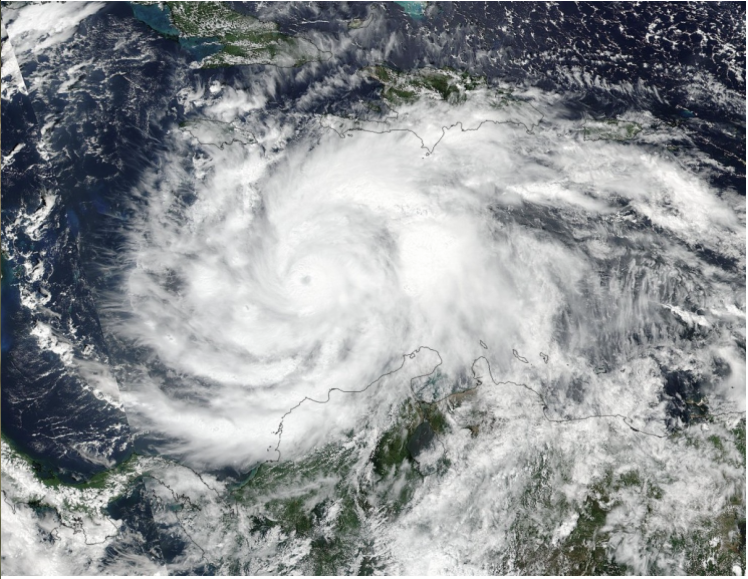
Hurricane Matthew underwent a remarkable rapid intensification of 80 mph in 24 hours, intensifying from a Category 1 hurricane to a Category 5 hurricane. This was the third-strongest rapid intensification in a 24-hour period for any Atlantic hurricane on record, trailing only Hurricane Wilma (2005) and Hurricane Felix (2007). It also became the first Atlantic-basin Category 5 hurricane since Felix (2007). Matthew is the 31st Atlantic-basin Category 5 hurricane on record. One of the remarkable things about Matthew during its time in the eastern Caribbean (<=20°N, 75-60°W) was its very slow forward speed. Typically, hurricanes have to move at least 8 to 10 mph to not churn up cold water, which would significantly weaken the storm. But the Caribbean is very warm and very deep, which means there was less cold water to churn. As such, Matthew has been able to sustain itself as a very strong hurricane for a long time. Because of its slow movement and strong intensity, it has achieved several notable records for intensity and duration.
Hurricane Matthew is the longest-lived Category 4-5 hurricane in the eastern Caribbean on record. The storm was a Category 4-5 hurricane for 102 hours, which is the longest that a hurricane has maintained such a strength on record during October in the Atlantic basin. Matthew has been a major hurricane (Category 3-5) for more than five days, the longest-lived major hurricane since Hurricane Ivan (2004). One index that hurricane scientists frequently use when they assess integrated effects of a hurricane is accumulated cyclone energy (ACE). This index takes into account intensity and duration of a hurricane.
Hurricane Matthew generated the most ACE of any hurricane in the eastern Caribbean on record. As of Wednesday morning, Matthew had generated the most ACE by any single Atlantic hurricane since Igor (2010). Given the forecast track and intensity of Matthew, it is likely to be one of the highest-generating ACE storms of the past 50 years. Matthew has already devastated portions of the Caribbean along its slow northward trek. It made landfall as a Category 4 hurricane in Haiti and then in Cuba and is now currently bearing down on the Bahamas. As such, Matthew has set some notable landfall records as well.
It was the first Category 4 hurricane to make landfall in Haiti since Hurricane Cleo (1964). Matthew was also only the third Category 4 hurricane to make landfall in Haiti on record, in addition to Flora (1963) and the aforementioned Cleo. Hurricane Matthew was the first Category 4 hurricane to make landfall in Cuba since Hurricane Ike (2008). What potential future records are possible for Hurricane Matthew? The latest National Hurricane Center forecast as well as model guidance indicate that Matthew may last in the Atlantic for another week or more…
No hurricanes on record have made landfall north of Miami along the east coast of Florida in October, and as mentioned earlier, no major hurricanes have made landfall since Wilma in 2005. Each of these records has the potential to be broken in the next few days.
From CNN (Max Blau, Steve Almasy and Catherine E. Shoichet):
Here’s what you need to know now about the powerful storm that forecasters say is gaining strength:
• Authorities urged more than 2 million people to leave their homes in coastal Florida, Georgia and South Carolina as the storm neared — the largest mandatory evacuations in the United States since Hurricane Sandy hit the East Coast in 2012.
• Based on the latest projections, Matthew could make landfall in Florida early Friday as a Category 4 hurricane. It could also skirt the coast as it continues north. Outer rain bands from the storm are already approaching Florida.
• The storm has already killed at least 15 people in several Caribbean countries.
• It’s moving northwest at about 12 mph and packing 125 mph (205 kph) winds — a Category 3 storm. Thursday morning it was about 30 miles (45 km) south-southwest of Nassau, Bahamas, and 215 miles (350 km) from West Palm Beach, Florida.
• Florida Gov. Rick Scott offered a dire warning Thursday morning for people living in evacuation zones: “This is serious. … Don’t take a chance. A small movement (of the storm) could mean a lot. That’s why we have to prepare for a direct hit. So again, if you need to evacuate and you haven’t, evacuate. This storm will kill you. Time is running out. We don’t have that much time left.”
• “This could be an extremely disastrous hurricane for so many large areas where so many people can be affected,” National Hurricane Center Director Rick Knabb told CNN Thursday. “It’s not just going to come ashore and affect a narrow zone and then move on. It’s going to be going up the coast and could remain a major hurricane at the coast, or very close to it, the whole way up. That’s awful.”