If there were people skiing at Crested Butte Mountain Resort on Sunday afternoon, more telling of this season of snowy abnormality were the driveways of homes and condo parking lots.
Poles had been placed along the edge of asphalt, to give snowplowers an idea of where to scrape. The poles stood in just an inch or two of snow, if that.
A bountiful winter this is not, at least so far in resorts in Colorado and more southerly locations of the continent.
In the San Juan Mountains, even less snow was evident over the weekend. Travelers to Telluride commonly will travel from Ridgway to Dallas Divide, passing as they do the stunningly beautiful hay meadows of the ranch owned by Ralph Lauren. Snow is the common denominator for Christmas week, but almost no snow was evident Friday amid the hay stubble.
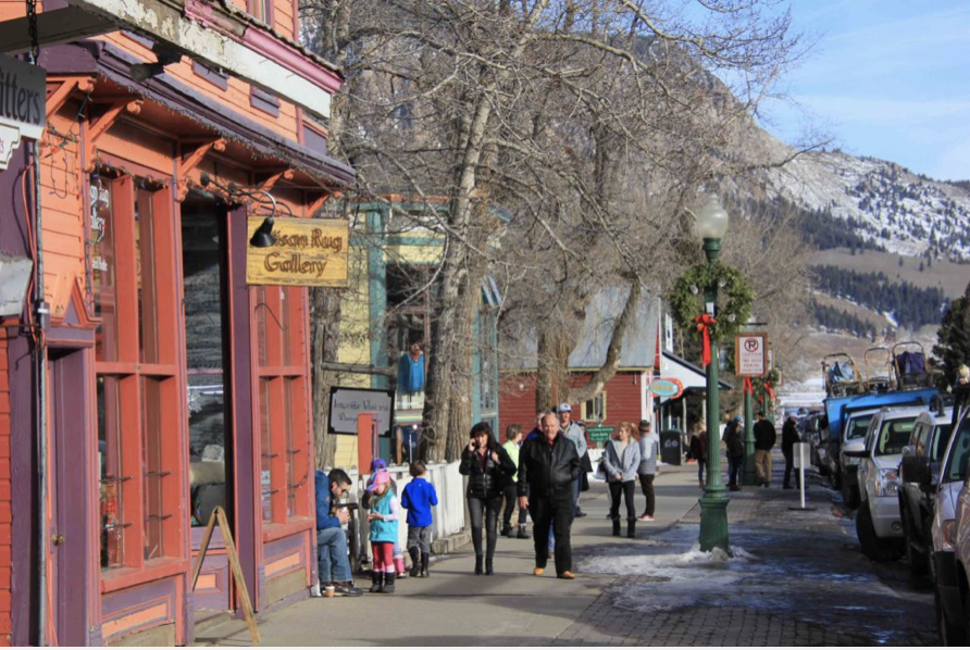
At Telluride, one man was walking in shorts, and skis were almost entirely absent from the town streets. The Plunge, the famed ski run, showed as much grass as snow. Along Colorado Avenue, the town’s main artery, doors were open and shops were busy.
Doors were open, shoppers were thick, and snow scant in Crested Butte on Sunday. Photo/Allen Best
Vail had more natural snow but still not very much. A resident reported the village streets were busy—too busy. There were people in town because there just wasn’t that much excuse to be on the ski hill.
Shops along Crested Butte’s Elk Avenue were busy, too, the doors wide open because it just wasn’t that cold.
In Tahoe, it was much the same story: abnormal heat and not much snow. The National Weather Service reported several highs were broken during the days after Christmas. The Tahoe Daily News reported many injuries on the ski slopes. “Without fresh snow, injuries are more common at ski resorts because of the hard-pack conditions,” the website noted.
Have their been more barren winters in Colorado during the modern ski era?
At the Rocky Mountain Biological Laboratory near Crested Butte, billy barr (his choice of capitalization) has been keeping track of snow and temperatures since 1974. This winter has been surpassed by the lack of snow only by that of 1976-77. What is also notable about barr’s weather records for this winter is the string of highest temperatures, including the highest temperature in his data base for New Year’s Day: 37 degrees.
That said, another winter, of 1980-81, invites comparisons. It, too, had sparse snow and warm temperatures. On Jan. 1 of that winter, the Denver Post published a photograph of a lift-op at Steamboat wearing a Hawaiian shirt and sitting in a lawn chair, no snow in sight.
From Pagosa Springs, Colo., comes this memory from Rod Proffitt: “I must be getting to be an old timer. I remember the 1976-77 winter very well. I had just moved from Aspen to Cripple Creek to start a law practice, but I had promised some friends I would come back for Winterskol that year.
Believe it or not, I was able to drive over Independence Pass mid-January that year. I had a cousin living in Crested Butte that year. With no snow, the perma-frost went down below the water lines and froze up the whole town. They had a miserable winter that year.
Cripple Creek rarely had a snow cover so their wood pipes were much deeper and survived that winter, but in the Spring a mountain goat died and fell into one of the reservoirs on Pikes Peak. The whole town of Cripple Creek got sick that year. Yes, it was a memorable year….”the year of no snow” to us old timers.”
FromThe Grand Junction Daily Sentinel (Amy Hamilton):
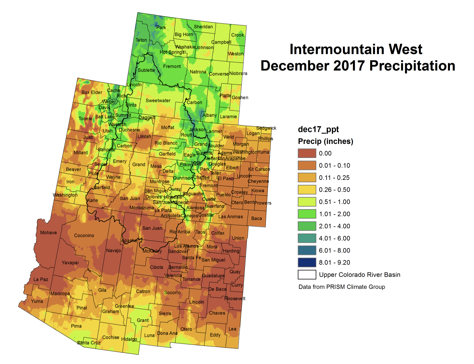
A lack of precipitation in 2017 made it the fourth-driest year on record, according to the National Weather Service in Grand Junction.
Since Oct. 2, only 0.05 of rain fell in Grand Junction.
In comparison, 1990 is the driest year on record, followed by the parched years of 1956 and 2012. The National Weather Service started keeping tabs in 1893…
Rain is expected Saturday afternoon and the storm should clear out by Sunday night, he said.
This weekend’s forecast storm should be followed by another storm building the following week from Jan. 11-13, Cuoco said.
With months of snow season yet to come, this should be considered very preliminary in nature. But the statistical probabilities suggest that, for many of New Mexico’s rivers, the chances of a record low year are higher than the chances of an average year.
Some numbers (all of these are median forecast numbers):
Rio Grande near Lobatos, near the Colorado-New Mexico border: 15 percent of average
Embudo Creek at Dixon: 16 percent of average
Rio Grande at Embudo:
Rio Grande at Otowi: 24 percent of average
Rio Grande at San Marcial, at the head of Elephant Butte reservoir: median forecast of essentially nothing, which is not plausible but the snowpack is so lousy that the model kinda breaks here
Pecos at Santa Rosa: 18 percent of average
A few things to remember.
First, it could snow a lot. These numbers could come up. The forecasts for the next month are “meh“, but this could happen.
Second, it could get worse. See previous link to “meh” forecast for the next month, and also recall that both the recent weather and the long term climate have trended on the warm side, which means that for a given amount of snow, paltry as it is, less water is ending up in our rivers.<
On January 8, the Supreme Court will hear an original jurisdiction dispute among three states that share interests in the flows of the Rio Grande/Rio Bravo del Norte: Texas, Colorado and New Mexico. The congressionally approved Rio Grande Compact of 1938 apportioned water rights among these states. In 2014, the Supreme Court granted Texas’ motion for leave to file a complaint and the court’s appointed special master, A. Gregory Grimsal, has been working through preliminary matters since then. The United States filed a complaint in intervention against New Mexico as well. The upcoming argument focuses on the first interim report by the special master, which considered a motion to dismiss filed by New Mexico against the state of Texas and the United States and motions to intervene filed by an irrigation district and a water improvement district. On October 10, 2017, the court denied New Mexico’s motion to dismiss Texas’ complaint and denied the intervention motions by the two local water entities. The exception of the United States and the first exception of Colorado to the first interim report of the special master were set for oral argument, and those matters will be before the court on Monday, January 8, as part of an interstate-apportionment double header.
New Mexico political and agricultural leaders will travel to Washington, D.C. for oral arguments in the U.S. Supreme Court case, Texas v. New Mexico and Colorado on Monday.
The litigation at hand involves a decades-old dispute among states in the southwest: Water…
In 2008, EBID and its sister district in El Paso entered into an operating agreement that provided El Paso with extra water to make up for those impacts of pumping here in the Mesilla Valley, Faubion said. Texas sued New Mexico in 2013, alleging a violation of that agreement.
“Texas made it clear at the time that if they challenged the operating agreement, that Texas would feel obliged to go to the Supreme Court, and that is exactly what happened and that is exactly why we’re here where we are today,” Faubion said.
“This is a huge issue that could affect states all across the nation,” said Samantha Barncastle Salopek, General Counsel for the Elephant Butte Irrigation District.
Barncastle told ABC-7 that this could be a precedent-setting case because the federal government has moved to intervene in the dispute among states.
“What the United States has said is that they have enough of a federal interest in this contract, that even though they have not signed on to it, they’re not a party to the contract, they should still be allowed to come into this case and litigate as though they were a party to the contract,” Barncastle said.
Las Cruces city officials would not comment on the case because of pending litigation.
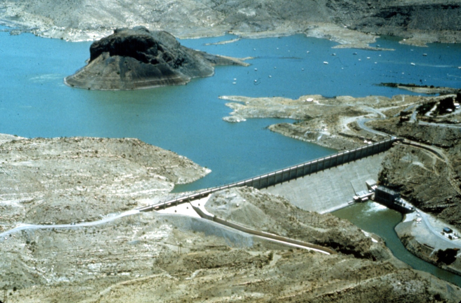
Elephant Butte Reservoir back in the day nearly full
Click here to go to the US Drought Monitor website. Here’s an excerpt:
Summary
During the 7-day period (ending Tuesday morning), bitterly cold, mostly dry weather prevailed across the nation. However, light to moderate showers were observed along the central Gulf Coast, while moderate to heavy rain and mountain snow were reported in the nation’s northwestern quadrant. At the end of the period, a moderate to deep snowpack extended from the interior Northwest across the northern Plains into New England. The overall trend toward drought intensification persisted from the Four Corners to the southern Plains and south-central U.S., while modest reductions in drought intensity and coverage were made in northern Montana…
High Plains
Extreme cold gripped the region, accompanied by much-needed moderate to heavy snowfall. Temperatures for the period averaged 25 to 35°F below normal from eastern Montana into the Dakotas and northern Nebraska. There were no changes made to the drought depiction in central and eastern portions of the region, while reductions in Abnormal Dryness, Moderate Drought, and Severe Drought (D0-D2) were made in northwestern Montana to account for the favorable start to the Water Year and the easing of long-term moisture deficits; 12-month precipitation climbed to near-normal levels in western Montana, but was still less than 50 percent of normal in the lingering Extreme Drought (D3) areas…
West
Drought intensified in the Four Corners, while heavy snow brought welcomed drought relief to northeastern portions of the region. Across Montana, Abnormal Dryness to Severe Drought were trimmed along the Canadian border to account for the favorable start to the Water Year and subsequent easing of long-term moisture deficits; 12-month precipitation climbed to near-normal levels in western Montana, but was still less than 50 percent of normal in the lingering Extreme Drought (D3) areas. While no changes were made to the Pacific Coast States, the poor start to the current Water Year was raising concerns over drought resumption from the Cascades southward into central and southern California. In particular, 90-day precipitation has averaged less than 40 percent of normal from central Oregon southward into central California, and less than 10 percent from the southern San Joaquin Valley into southern portions of Nevada and Arizona. Severe Drought (D2) was expanded over large portions of the Four Corners region, coincident with much-below-normal precipitation totals over the past 6 months (30-65 percent of normal). Farther east, Moderate Drought (D1) expanded across northern portions of New Mexico and environs, where short-term dryness (10-40 percent of normal over the past 90 days) was most pronounced…
Looking Ahead
A rapidly-intensifying storm system near the Atlantic Seaboard will produce wind-driven snow from parts of the Mid-Atlantic into the Northeast. Substantial snow- and wind-related impacts are expected in New England, as well as coastal cities such as Savannah, Georgia, and Charleston, South Carolina. In the storm’s wake, late-week temperatures will again plunge across the Midwest and Northwest. However, temperatures will rebound to above-normal levels by Sunday in all areas west of the Mississippi River. In the middle and lower Mississippi Valley and environs, some rain or freezing rain could precede the warmer weather. Elsewhere, periods of rain and snow will affect northern California and the Northwest, while dry weather prevails across the central and southern Plains. The NWS 6- to 10-day outlook for January 9 – 13 calls for above-normal precipitation across much of the nation, with drier-than-normal weather confined to the nation’s southern tier save for the Southwest. Colder-than-conditions will linger in the upper Midwest, while near- to-above-normal temperatures prevail elsewhere, with the greatest likelihood of abnormal warmth from the Rockies to the Pacific Coast.
Take a trip back in time. Click on a thumbnail graphic to view a gallery of drought data for early January over the past few years.
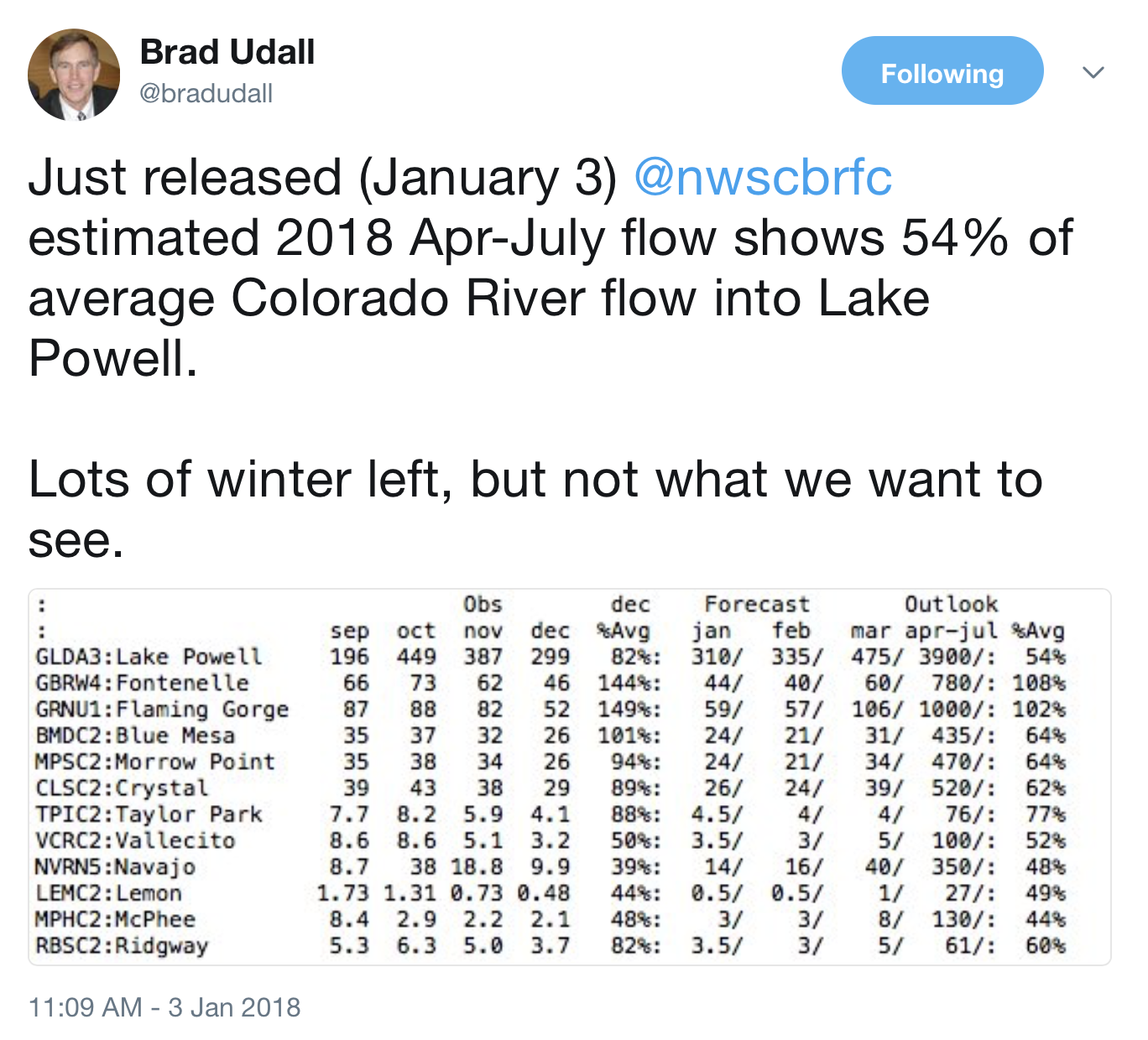
The National Weather Service’s Colorado Basin River Forecast Center predicts the river will flow at about 54 percent of its average volume during the key runoff period from April to July…
There’s still plenty of time for conditions to improve. The river basin tends to accumulate much of its snowpack in January, February and March…
Lake Mead ended 2017 almost 2 feet higher than a year ago, as use of Colorado River water by Nevada, Arizona and California hit its lowest level since 1992.
According to preliminary accounting figures from the U.S. Bureau of Reclamation, the three states consumed a combined 6.7 million acre-feet from the river last year, driven by wet conditions in California and widening efforts to curb use in Arizona…
That left enough water in Lake Mead to keep it more than 7 feet above the trigger point for a federal shortage declaration, which would mean mandatory cuts for river users in Nevada and Arizona.
Colorado River author and expert John Fleck said the reduction in consumption is impressive considering the population in the areas served by the river has grown by about 7 million people since 1992.
“It’s a sign that we are succeeding in using less water in the Lower Colorado Basin,” said Fleck, director of the Water Resources Program at the University of New Mexico in Albuquerque. “It’s critical that we’re learning to do this, because this isn’t enough. … We’re going to have to do it more.”
[…]
California was able to cut its river use by more than 440,000 acre-feet last year, in large part because of huge snow accumulations in the Sierra Nevada mountains that helped refill the state’s drought-depleted reservoirs and above-average precipitation elsewhere that reduced water demand.
Fleck said Arizona cut its river use by almost 360,000 acre-feet mostly to stave off more substantial, mandatory cuts in the future. “Arizona has been cranking down their use to try to avoid a shortage,” he said.
Nevada used about 239,000 acre-feet of its 300,000 acre-foot allocation in 2017, an increase of roughly 2 percent over the previous year.
Bronson Mack, spokesman for the Southern Nevada Water Authority, water use in the valley went up slightly last year because of increased economic activity and the addition of more water customers. Hotter, drier weather also may have played a part, he said…
Federal projections released last month called for Lake Mead to finish 2018 roughly 4 feet lower than it is now but still safely out of shortage territory. In light of Wednesday’s ugly — but early — river forecast, the projections for the lake are almost certain to get worse.
What is it about snow that makes it so tough to pin down?
Though temperatures at ground level are important, the critical numbers for assessing snowfall are much higher up in the atmosphere. We’re looking for ice crystal growth, which happens when the air is wet enough and cold enough—sometimes down to -20° Fahrenheit, though the biggest snow growth happens at somewhat warmer temperatures.
The ice crystals start small, but as they collide they grow, until finally they’re large enough and heavy enough to fall to Earth. Snow is water plus air—air being very important. It’s the fluff factor, the reason an inch of water can be 5 inches of snow or 30 inches or something in between. The snow liquid ratio, or SLR, is different for every storm (high SLRs are good for skiing, bad for snowballs). And that’s what we’re trying to predict—how much liquid is going to produce how much snow.
Most snowstorms are driven by low pressure systems hundreds of miles across. Around the low, warm air rises and cools. That causes water vapor in the air to condense and form clouds. Liquid droplets come next until gravity and temperature begin to dominate. For those who live in snow belts there’s a second method to produce snow, the lake effect. Assessing these two methods of snow production should allow you to get a good idea of how much snow to expect, but often your final estimate is really the combination of two estimates.
The process is very exacting, intricate even. When temperatures are cold enough and the wind properly aligned through the atmosphere, lake effect snow produces narrow bands of intense snow that are extremely hard to predict. For example, I drove from Buffalo to Erie, PA one winter’s day. Downtown Buffalo had flurries, but as I headed into the “Southtowns,” conditions became dicey. The snow rate was a few inches an hour. And then, a few miles later along Lake Erie’s shore, the snow stopped, clouds parted, and the sun came out. My trip back saw the exact same conditions in the exact same places. Nothing had moved.
Marquette, Michigan is a good example of how this makes forecasting more difficult. Not only does Marquette get your run-of-the-mill winter storms, they also get lake effect snow. Lake effect there has an SLR in the 30 to 40:1 range, meaning that one inch of liquid equals 30-40” of snow. The larger storms that pass through are 10 to 15:1. Figuring out how this hybrid storm is going to combine includes a lot of room for error. Luckily, Marquette averages around 17 feet of snow per year—lots of time to practice.
So we forecast the amount of water, then how that water will act as it drops. Most of the time the atmosphere warms as the flakes fall…but not always. What starts in the clouds as snow can fall as sleet, rain, freezing rain or even grauple (snow flakes pocked with rime ice). The form it falls in obviously changes how much snow ends up on the ground.
When and how you measure snow affects the final total, too. Officially it’s measured off the ground on a ‘snow board,’ usually a large piece of plywood. Snowflakes fill gaps in the snow pile as they fall. Measuring every hour, without giving the snow time to settle will give a higher amount than measuring every six.
Over the years forecasts have improved. There are fewer busts. One reason we’ve gotten better is through improved computer modeling: We can now look at the atmosphere a little more finely. The grid points and time steps are closer together. The mathematical integration of physics is better honed.
There are multiple important mountain locations contributing to southern Colorado’s water supply. Right now snowpack on Pikes Peak is just less than 30% of what’s considered normal for this time of year. Sources closer to the continental divide are better, but also very low. The Arkansas river basin at about 50% and the Upper Colorado River basin just above 65%.
The numbers are benchmarks at about half way into the snowpack season. It is typical to get heavier water dense snowstorms in January, February and March, but some long term forecasters are seeing some indicators of a storm track with lower snow totals.
A major buffer preventing immediate concern is the current level of our reservoirs. A couple of very wet years before now, have filled reservoirs. For Colorado Springs, storage is enough for three years.
From the Pueblo West View (Christine Ina Casillas):
Water leak detection
The Pueblo West Metropolitan District hired some new crew in 2017 to help with water leak detection.
These two new staff members will be responsible for water leak detection and repairing the leaks along the 430 miles of potable water lines that run underneath Pueblo West.
Because shale rock formations, just under the ground surface in Pueblo West, many leaks can go undetected for long periods of time, said Jay-Michael Baker, communications and engagement manager with the Pueblo West Metropolitan District.
The water lost in a leak can follow these formations for hundreds of feet in some cases, and then only reach the surface in drainage ditches out of sight of the everyday operations staff and most residents.
“In one recent case the water from a main line leak found its way into the sewer system,” Baker said.
“This leak was discovered when treatment operators observed extra flow in a lift station. Their tip helped the leak detection crew locate the source of the leak.”
Since the leak flowed into the wastewater treatment system, it not only increased the cost of the lost water, but it also increased the cost of treating the extra water.
Detecting and repairing this leak saved the District a significant amount of money.
“I am very pleased with the work of the entire Collection and Distribution department,” said Scott Eilert, director of Utilities for Pueblo West.
“Particularly Rusty Ethredge, department manager, and Ben Gomez, who has taken the lead on the leak detection crew.”
The leak detection crew has located and repaired 10 significant leaks since last October.
The leak detection crew is credited with saving the District 480,685 gallons of treated water; enough to serve the average use of three single family homes for an entire year, Baker said.
“It is impossible to know exactly when a pipeline began to leak so we calculate the lost water from the date and time the leak was located until it was fixed,” Baker said.
Since the leak detection crew came in to service in October 2016, the approximate cost savings to the District for leak detection has been in the tens of thousands of dollars, he said.
In addition to the District’s recent water conservation plan, Pueblo West is conducting telecommunications and energy audits this year to identify waste, and decrease inefficiency.
Operating with a lean budget, any cost-savings that Pueblo West Metro management staff can find improves the quality of services provided to residents, he said.
Because the Pueblo West Metropolitan District looks for ways to increase efficiency and prevent waste within the district, finding solution through regularly reviewing processes and weak points is highlighted, he said.
The District’s water conservation plan, approved by the Colorado Conservation Board in August 2012, ranked leak detection as a high priority, Baker said. In response to this recommendation, the Pueblo West Metro Board approved two new full-time positions dedicated to leak detection for the 2016 budget year.
Water rate hikes
When Pueblo West residents opened their water bill from the September billing cycle, they said they were aghast at the price hike.
Some said it was a significant enough increase that they called the Pueblo West Metropolitan District with concerns about water leaks.
Officials with Pueblo West Utilities held a community meeting on Nov. 29 to answer questions from the public about the water rate increases and about the five-year water and wastewater rate plan.
Residents questioned where and how the water fees applied to their monthly bills and costs associated with sewer charges and leaks.
Kim Swearingen, deputy director of utilities for Pueblo West, said the bill period begins around the 10th of the month, give or take holidays, and go through a 31-day cycle.
For example, she said, the water bill would begin on Oct. 10 and end on Nov. 11. The data from the reading would be analyzed by Nov. 26 and the bill would be sent out and due in December for the October billing cycle.
“It’s almost like a three-month (billing) cycle but it only looks at that 31-day billing period,” she told residents during the meeting on Nov. 29.
The Pueblo West Metropolitan District Board of Directors will hold a final public hearing on Dec. 12 to approve a Water and Wastewater rate increase that will take effect Jan. 1.
The increase is part of a long-range comprehensive financial plan that was first initiated in March 2016 and partially funded by the Colorado Department of Local Affairs.
The plan recommends a five-year phased implementation that accounts for five years of operations and maintenance costs and a 10-year capital improvement plan.
The 10-year capital improvement plan lays out all long-term infrastructure needs for the Utilities Department.
The intent of the plan is to ensure the Utilities Department has sufficient revenues for the ongoing functions of the water and wastewater enterprises.
Inflation-induced increases in operating and maintenance costs, aging infrastructure, and long-term planning were all factors covered in the long-term financial plan.
The Utilities Department presented the increases to the Board of Directors at over a half dozen Board Meetings over the past two years.
Scott Eilert, director of utilities for Pueblo West, offered examples of projects to receive funding include: a gravity sewer main that serves Tract 220 and the large lot on the northwest corner of Highway 50 and McCulloch Boulevard, a lift station and force main at States Avenue Industrial Park, the rebuild of a pressure zone on Tract 251, a two million gallon water tank on the north side, and wastewater treatment plant upgrades, in addition to dozens of smaller capital projects.
On Sept. 1, the first phase of the rate increase went into effect resulting in an increase of approximately 4.6 percent for an average single-family monthly bill for both water and wastewater.
On Jan. 1, the second rate adjustment will take place with an estimated increase of 4.7 percent for an average single-family monthly bill.
The remainder of the plan adjustments are intended to take effect on Jan. 1 of each year through 2021 after the public hearing.
The water and sewer Plant Investment Fees saw a one-time increase on Sept. 1 and the district does not anticipate adjusting the PIF again within the five-year plan, Eilert said.
Credit: Cattleman’s Ditches Pipeline Project II Montrose County, Colorado EIS via USBR.
Click here for all the inside skinny and to register:
Flexible water sharing agreements or alternative transfer methods (ATMs) could help keep water in agriculture while supplies are shared with municipalities or others to meet the many water needs of the state’s population. Colorado’s Water Plan calls for 50,000 acre-feet of water to be identified in ATMs by 2030.
How can Colorado reach its goal and scale up the adoption of alternative transfer methods? Join Water Education Colorado to explore the conversations around existing policy and policy changes that might increase the adoption of ATMs.
We’ll hear from expert speakers:
Kevin Rein, Colorado’s State Engineer Peter Nichols, Special counsel to the Lower Arkansas Valley Water Conservancy District and to the Lower Arkansas Valley Super Ditch Co., Inc. Jim Yahn, Manager of the North Sterling Irrigation District
When: January 11th, 2018 9:30 AM through 10:30 AM
Webinar Fee:
WEco member $ 10.00
non-WEco member $ 15.00
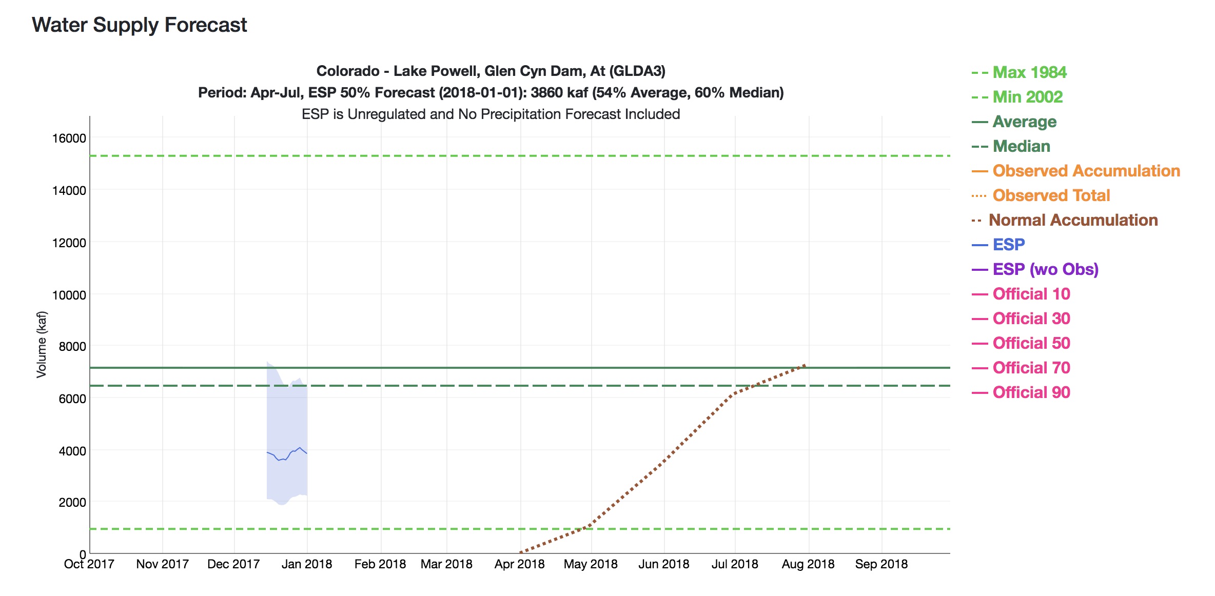
The folks at CBRFC has done a lovely update of their graphical presentation. The story it’s telling right now – not so lovely.
Let’s take this step by step.
First, the green lines in the middle of the graph. Those are “average” for the April-July runoff, where the solid line is the mean, and the dotted line is the median. (UNM WRP students, there’ll probably be a question at some point on the quiz about the difference, and why you’d choose one or the other for policy discussions. Prof. Fleck is just kidding, right?)
The dark blue line is the automated forecast, based on current snowpack and some mathemagic the CBRFC uses that we all trust. The light blue band is essentially the error bounds, where the top of the bar says there’s a one in ten chance it’ll be that high, and the bottom a one in ten chance it’ll be that low.
Then, reading left to right, the X axis is the date of the forecast. So the fact that the blue line is below 4 million acre feet means that when they did their mathemagical incantations (I believe that’s the technical term) on Jan. 1, they concluded that there’s a wide range of possible runoffs, spread from just above 6 million acre feet to just above 2 million acre feet, with a midpoint a bit under 4 million acre feet of inflow into Lake Powell this runoff season.
But another way, this is really, really bad. Or, as one of the smart managers said in an email this morning, “sobering”.
Clouds with a Silver Lining: Seeding Storms to Boost the Colorado River
In much of the West, demand for water is projected to outpace supply, especially in the Colorado River basin, which provides drinking water to over 40 million people. There are various strategies to close the gap–some controversial like building new reservoirs and others more widely accepted like conservation.
But what if you could just wave a magic wand and make it rain or snow? It’s not impossible and in fact, it’s been going on in the West for years.
It’s called weather modification, better known as “cloud seeding.” With a changing climate and drier future, many are looking to the technique to boost snowpack in the mountains to meet growing water needs. More snow, even a small percentage can mean more runoff—and more water to cities and farms.
Back in the fall we drove with Joe Busto from the Colorado Water Conservation Board out of Fraser, Colorado, in the Rocky Mountains to see a cloud seeding operation firsthand—and meet some of the people involved. Busto says they’re trying to “put extra snow in the bank where you need it for water supplies” and that cloud seeding has been shown to add anywhere from 5 to 15 percent to the snowpack.
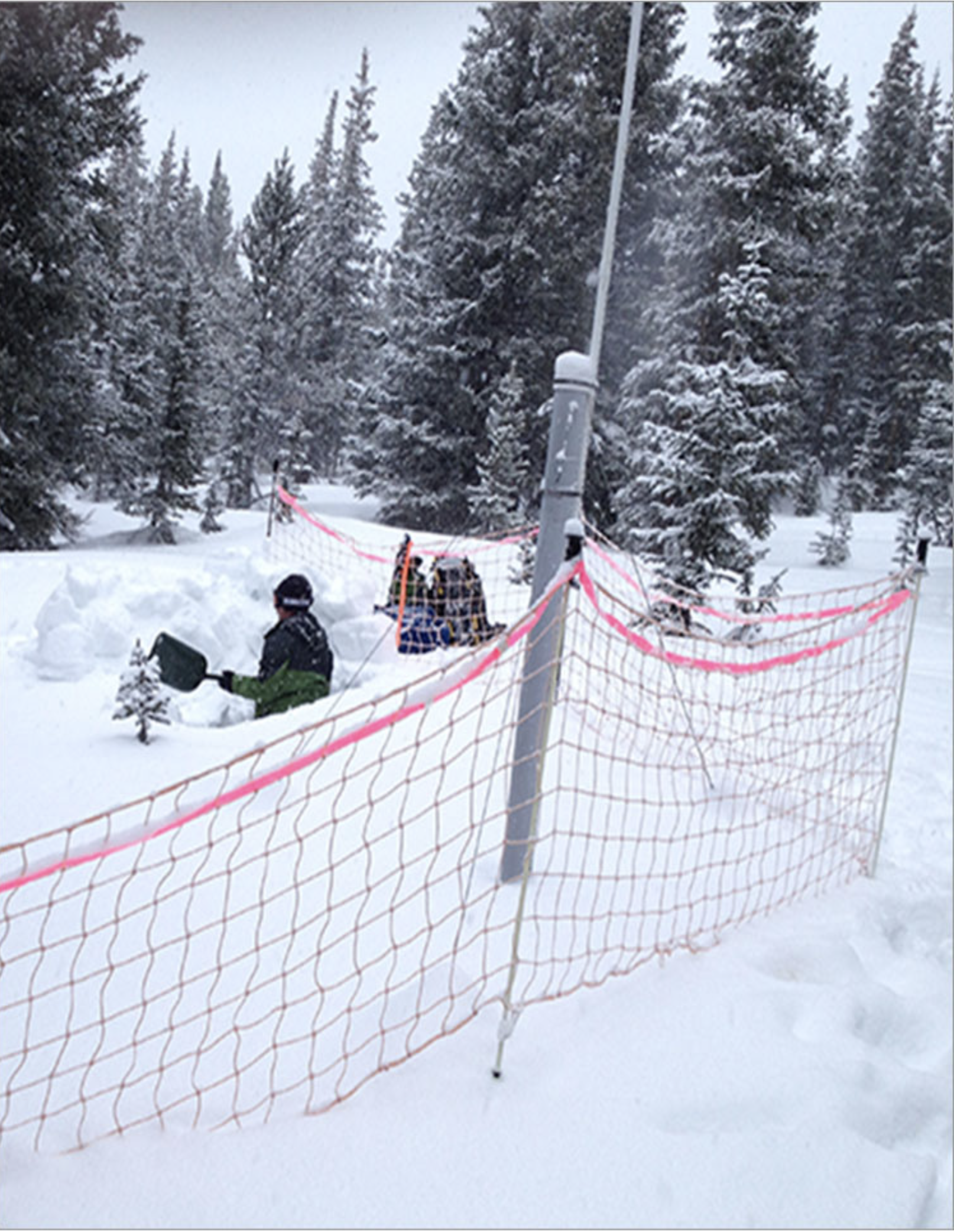
Snow pit at Winter Park — sampling for silver iodide. Photo via the Desert Research institute.
There are about 40 total sponsors of cloud seeding in Colorado, including regional water districts, the state of Colorado, local water districts, cities, towns, counties, and nine of the state’s 28 ski areas.
With us in the car is Maria Pastore, who represents some of those entities that range from Denver Water and Colorado Springs Utilities to ski areas like Winter Park, which we’re not too far from as we drive. For a state with much tension around moving water across the Continental Divide, Pastore says cloud seeding is being embraced by both sides. She says they have a large group of collaborative sponsors, and cloud seeding is probably one of the arguably least contentious programs for the West Slope and East Slope partners.
Pastore’s group works with ski areas for cloud seeding because you get more bang for the buck. They’re already located in places that typically get a lot of snow—and they provide a recreational benefit. After folks have schussed or snowboarded across it, the snow will melt and flow into the tributaries of the Colorado River to become drinking water and to turn turbines in hydroelectric dams.
We arrive at a spot that could pass for a nice campsite. Parked on it is a small camouflage-painted trailer with a twenty-foot mast sticking up in the air—and a barrel on top. Waiting for us by the trailer is Jeff Dean of the Desert Research Institute, or DRI. Dean and his team are at this site to get the cloud seeding equipment, called the generator, ready for the season ahead. So how does cloud seeding work?
Dean explains that cloud seeding is done by adding extra dust to the air. A typical cloud will only drop maybe five percent of its available moisture. They’re not very efficient. Inside every cloud droplet and every snowflake there is a piece of dust—nuclei that started the process. In cloud seeding, they’re just introducing a little bit more of that dust. They do that by burning silver iodide, which goes up in the air to start the growth of a crystal that eventually will turn into a snowflake.
DRI has meteorologists watching several factors like wind speed, humidity, and temperature to identify the perfect moment to fire up the generator to hit their intended target, which in this case is the Winter Park ski area and Denver Water’s drainage.
Dean is out here with us to demonstrate how they start up the equipment. With a tap on his laptop the generator begins to hum. Dean could have been in his office in Reno or on a beach in Maui to activate the system. We watch inside the barrel and after a few seconds a bright yellow, robust flame appears, which indicates that the silver iodide solution is starting to burn. Dean says that last year this generator produced 22 inches of snow for the ski area.
So how do they know it wouldn’t have snowed anyway? They assess that by looking for traces of the silver iodide in the snow. DRI did an analysis at the Winter Park ski area where they went halfway up the lifts and did a full profile all the way to the ground by inserting test tubes every ten centimeters. They then weighed the samples and did a chemical analysis. They found trace amounts of the silver, which according to the state of Colorado, are at extremely low concentrations and not harmful.
The cloud seeding program isn’t just being sponsored by providers in Colorado. Downstream users in other states who depend on a good Rocky Mountain snowpack are also on board. Joe Busto says that after the drought in early 2000s, it was bad in Colorado, but the state rebounded quickly because reservoirs are next to the mountains. But the lower basin states downstream on the Colorado River—Arizona, California, and Nevada—came knocking on the door and said, “Lake Powell and Lake Mead are drying out…”
The result was a partnership among the Southern Nevada Water Authority that serves Las Vegas, the Central Arizona Project, and six agencies in California including the mega-one in L.A. All now help fund cloud seeding in Colorado.
So while recent storms are thrilling skiers, a good base on the slopes this year may also contain a silver lining for water users hundreds of miles away.
Detailed Colorado River Basin map via the U.S. Bureau of Reclamation.
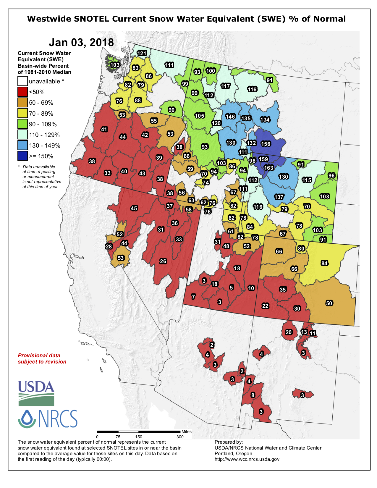
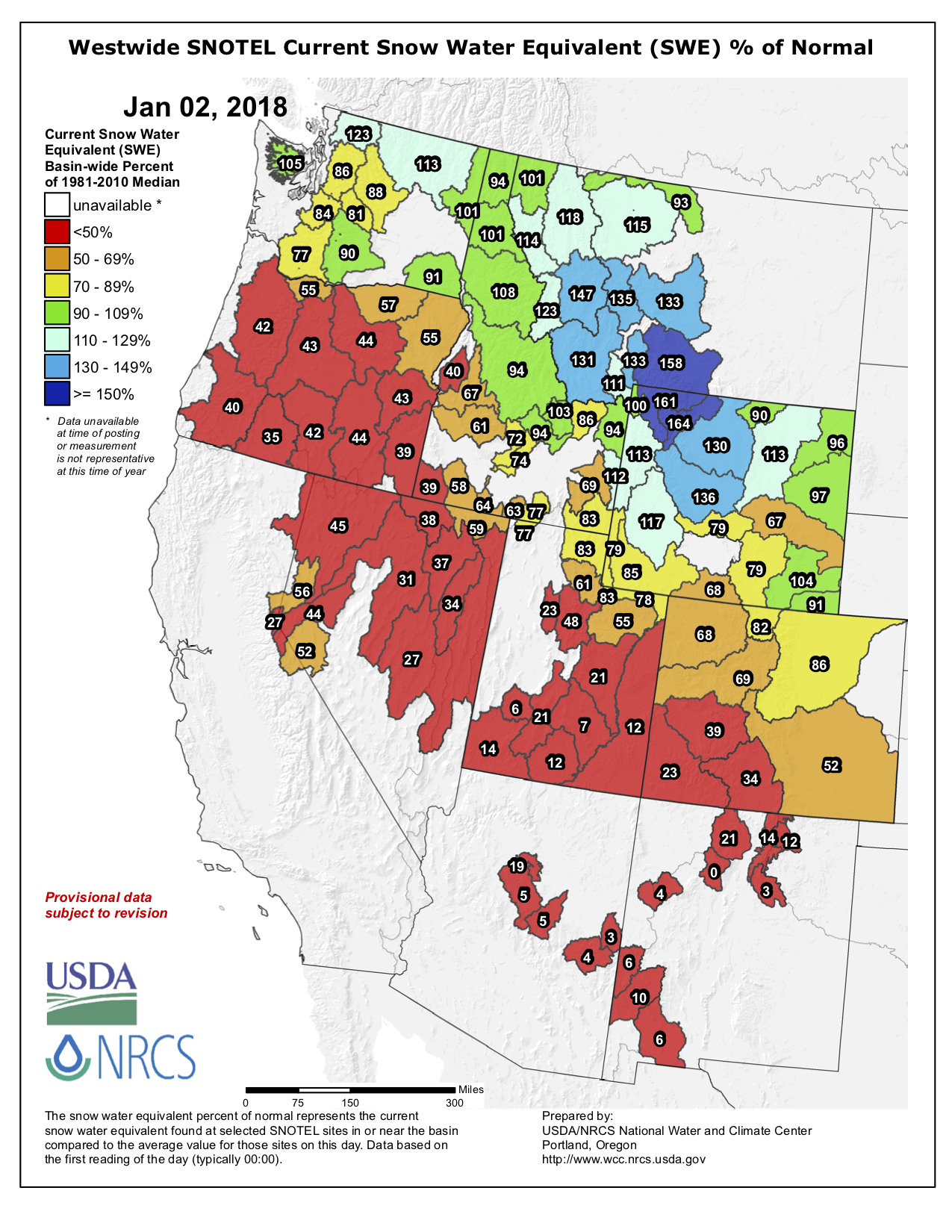
Westwide SNOTEL basin-filled map January 2, 2018 via the NRCS.
FromThe Grand Junction Daily Sentinel (Dennis Webb):
Brian Domonkos, snow survey supervisor for the Natural Resources Conservation Service in Colorado, said Tuesday that according to one of the agency’s data sets that goes back 33 years, this is the second-worst start to a snowpack season in that time, with only the 2000 water year being worse.
Water years begin in October of the previous year. Domonkos said that as of the start of January, Colorado typically is about 43 percent of the way through its snowpack accumulation, so it needs well-above-normal snowfall the rest of this season to make up its current deficit…
Southern Colorado “has stayed extremely dry,” while northern Colorado has fared a bit better but is still somewhat dry, Domonkos noted.
Said Ben Moyer, a National Weather Service meteorologist in Grand Junction, “The northern mountains have been doing pretty good. They’re still below normal but I think they’re holding up the state for us right now” from a snowpack perspective.
NRCS data Tuesday showed the South Platte River Basin leading the state with snowpack at 86 percent of median. The Upper Colorado was at 69 percent, the Gunnison was at 39 percent and basins in far-southwest Colorado were at just 23 percent.
The more generous snowfall in northern Colorado is consistent with this being what’s called a La Niña year, a reference to cooler water temperatures in the equatorial Pacific Ocean that affect U.S. winters. By contrast, El Niño winters, where those water temperatures are warmer than normal, tend to bring more moisture to southern Colorado than northern Colorado.
Moyer said the recent trend has been one of storms coming out of the northwest and across the northern Rockies.
“It creates some glancing blows of winter storms across the northern mountains of Colorado,” he said. “Even those systems have been pretty dry, relatively speaking.”
Moyer said a persistent ridge of high pressure over the West Coast has been blocking storms from coming in from the southwest. The forecast shows that ridge breaking down this weekend, allowing a trough of low pressure to move in late Saturday and into Sunday, bringing some precipitation to the state, he said. He said more snow could arrive around the middle or end of next week.
One promising sign is that late January and early February appear to be a little more active period in terms of precipitation in Colorado in La Niña years, Moyer said…
Domonkos said there still are “way more than a handful of sites” at which the NRCS measures snowpack where less than an inch of snow-water equivalent has been recorded.
The agency’s Mesa Lakes site on the Grand Mesa had just 1.1 inches of snow-water equivalent Tuesday, compared to a Jan. 2 median amount of 6.7 inches. Powderhorn Mountain Resort has been able to operate only on limited terrain so far this season, as has been the case for some other ski areas in the state, including Sunlight Mountain Resort outside Glenwood Springs…
Storage was above average in every basin, including the Colorado River Basin (110 percent of average) and the Gunnison (108 percent of average).
Grand Junction back in the day with the Grand Mesa in background
Elephant Butte Reservoir back in the day nearly full
FromThe New Mexico Political Report (Laura Paskus):
“I’m openly skeptical we’ll ever be able to fill Elephant Butte Reservoir again,” Dr. David Gutzler told attendees of a recent climate change conference. That’s given the trend toward diminished flows in the Rio Grande resulting from the continued global rise in temperature.
The University of New Mexico Earth and Planetary Studies Department professor delivered the grim news on a crisp, yellow and blue fall morning along the bosque in Albuquerque.
Since the U.S. Bureau of Reclamation completed the reservoir in 1916 to supply farmers in southern New Mexico and Texas with water, the reservoir’s levels have fluctuated—from highs in the 1940s to lows in the 1950s, ‘60s, and 70s. Many New Mexicans are familiar with the wet period that lasted from 1984 through 1993; between 1980 and 2006, the state’s population increased by 50 percent. But then the region was hit with drier conditions—and increasing temperatures. Areas of the Southwest have suffered from drought since 1999 and, unlike earlier droughts, it’s driven not just by a lack of precipitation, but a rise in temperature.
Even with good snowpack in southern Colorado and northern New Mexico the past few years, there simply isn’t enough water to boost the reservoir’s levels again, said Gutzler, who is also one of the lead authors of the Intergovernmental Panel on Climate Change’s 2013 Assessment Report. The reservoir is currently at just 15 percent capacity…
Warming in the American Southwest is occurring at about double the global rate—and that local warming will have a profound impact on water resources in the Interior West. Those changes in water supply will occur regardless of changes in precipitation, he said.
Gutzler added, “There is nothing the slightest bit hypothetical about this warming.”
On Friday, the U.S. government released its Climate Change Special Report and the fourth volume of the National Climate Assessment, an update of the last report released in 2014. It’s the culmination of work by 13 federal agencies mandated by Congress to assess climate science and climate change impacts every four years.
After about a year of gardening in a dome on the banks of the San Juan River in Pagosa Springs, the Geothermal Greenhouse Partnership plans to start construction on two more domes this spring.
Residents began planning the growing spaces in 2008 and 2009 during the Great Recession as a way to revitalize the town’s historic downtown. The vision was to provide an educational and growing space for all ages and demonstrate geothermal energy, said Sally High, the president of the nonprofit’s board of directors…
In addition to drawing in the public, it has also produced a bountiful harvest with thousands of tomatoes, leafy greens and other vegetables. The dome, 42 feet in diameter, produced enough bounty to sell at the farmers market in its first year, she said.
In the next phase of construction, the nonprofit plans a dome to house a community garden and an innovation dome, which will be used to demonstrate aquaponics – a hydroponic system that incorporates fish to help feed the plants, High said.
Construction of the new domes this spring will be funded by a $174,500 grant from the Colorado Water Plan Engagement and Innovation Fund and a $34,000 matching grant from the Colorado Garden Foundation.
When complete, the final cost of the project could be between $800,000 and $1 million, High said.
With the ground mostly brown just a few days before Christmas, some residents of Telluride gathered old skis and burned them in an offering to Ullr, in Norse mythology the god of snowshoes and some other items. The next day it snowed 4 inches at Telluride, reported the Daily Planet.
Coincidental or causal? Whatever. The San Juan Mountains have been so barren that just four inches was tantamount to a big dump in some winters.
Since then, a Christmas Eve storm left most of Colorado white. There was enough snow along the Continental divide in the Breckenridge to Winter Park area that avalanche forecasters warned backcountry skiers to definitely stay off slopes of more than 30 degrees…
But the blanket of snow across Colorado was not uniform. Telluride got just an inch, while Steamboat Today reported the local ski hill got 24 inches in two days. Ski areas in Montana and Wyoming did better.
In California, there was even less cause for holiday snow-white joy. There was no mistaking the Tahoe area for the North Pole at Christmas reported the Reno Gazette-Journal. “The mountains were patchy with snow all the way up, and the only snow falling as that made by the ski resorts.”
[…]
The problem for Colorado is the same as the problem for California: a persistent high-pressure ridge that has shunted moisture-laden storms northward. This has produced “almost inconceivably heavy snowfall in the coastal mountains of southern Alaska,” explained Daniel Swain in a Christmas Eve posting on the California Weather Blog.
Finally, here’s the Westwide SNOTEL map for January 2, 2018.
Westwide SNOTEL basin-filled map January 2, 2018 via the NRCS.
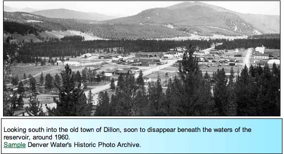
Warmer temps have left Dillon Reservoir for the most part unfrozen, typically the large body of water freezes over by the end of December. Not this year, though.
More dry weather and above average temperatures are predicted for the next few days. That leaves open the possibility of breaking the record this year.
A variety of natural forces — floods, fires, droughts and more — pounded the West in 2017, many of which are intensifying thanks to climate change. The year also saw an influx of evidence that humans have altered the earth’s climate so much that certain severe weather events would not have been possible in a pre-industrial world. “It’s quite bold for scientists to make these very strong statements,” says Andrew King, an expert weather and climate at the University of Melbourne in Australia. That unflinching stance from researchers suggests that 2017 may have been a turning point in their confidence in the links between climate change and specific disasters. “For scientists to say that an event would be virtually impossible without climate change — they’re very sure.” We rounded up some of the most notable climate and weather events that rocked the West:
Hot weather broke records
While scientists don’t expect 2017 to beat out 2016 as the hottest year on record (though it will likely be among the top three), several Western states broke monthly heat records in 2017. Colorado and New Mexico experienced the warmest March in each state’s history. Along the Pacific coast, California, Oregon and Washington set records for the hottest August on the books. Autumn scorched the Four Corners states: Arizona, Colorado, New Mexico and Utah each broke its November heat record.
La Tuna fire September 2017 photo credit StrangeSounds.com
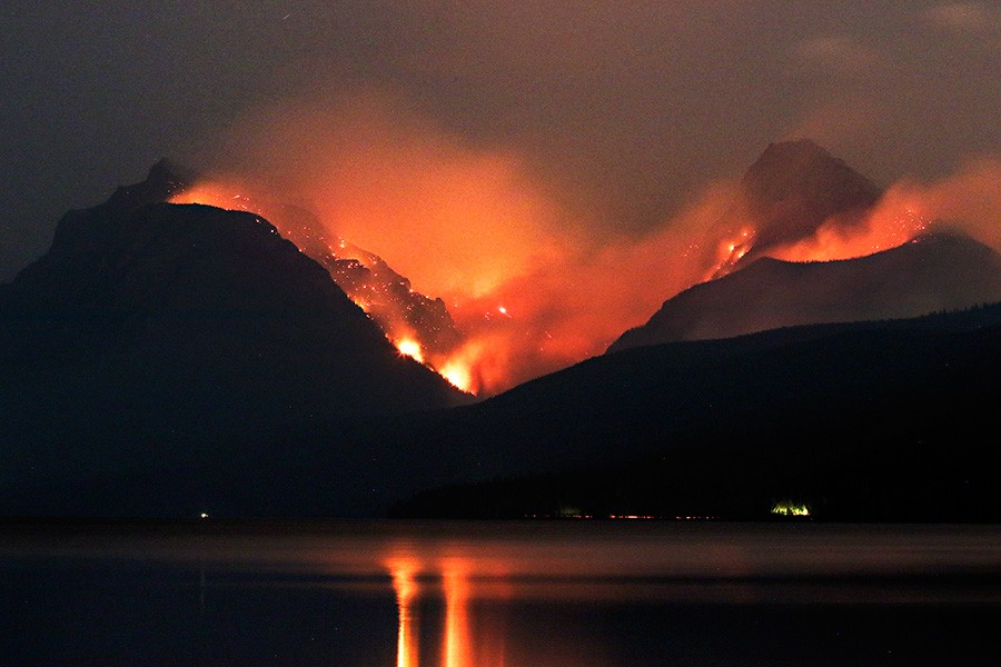
Fire spread smoke across the West
Wildfires raced across the West in 2017, with California hit particularly hard. The Golden State experienced the costliest, most destructive blazes in its history in October, when 44 people were killed and thousands of homes destroyed near Napa and Santa Rosa. Two months later, the Thomas Fire, now the state’s largest wildfire on record, started east of Santa Barbara on Dec. 4 and was still burning as 2017 came to a close.
In Montana, wildfires burned more than 1 million acres this year, filling the air with a haze of lung-damaging smoke, a problem that could get worse in the coming years. Scientists expect to see more fires and a longer fire season as temperatures rise across the West.
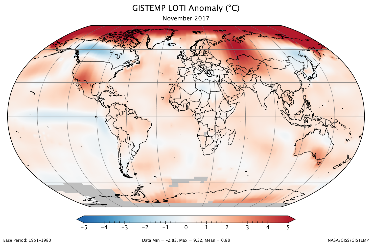
A global map of the November 2017 LOTI (land-ocean temperature index) anomaly, relative to the 1951-1980 November average. Part of Antarctica is gray because data from some stations there were not yet available at the time of this posting.
Arctic sea ice hit a new winter low
As the climate warms, the amount of sea ice in the Arctic is decreasing. Sea ice cover hits its maximum in March, when there’s typically two or three times as much ice as there is in September, after summertime melting. In March 2017, Arctic sea ice peaked for the year — and broke the record for the lowest winter maximum ever recorded.
That could drive changes far from the North Pole. In December, scientists from Lawrence Livermore National Lab published a study elucidating the link between Arctic sea ice loss and drought in California.
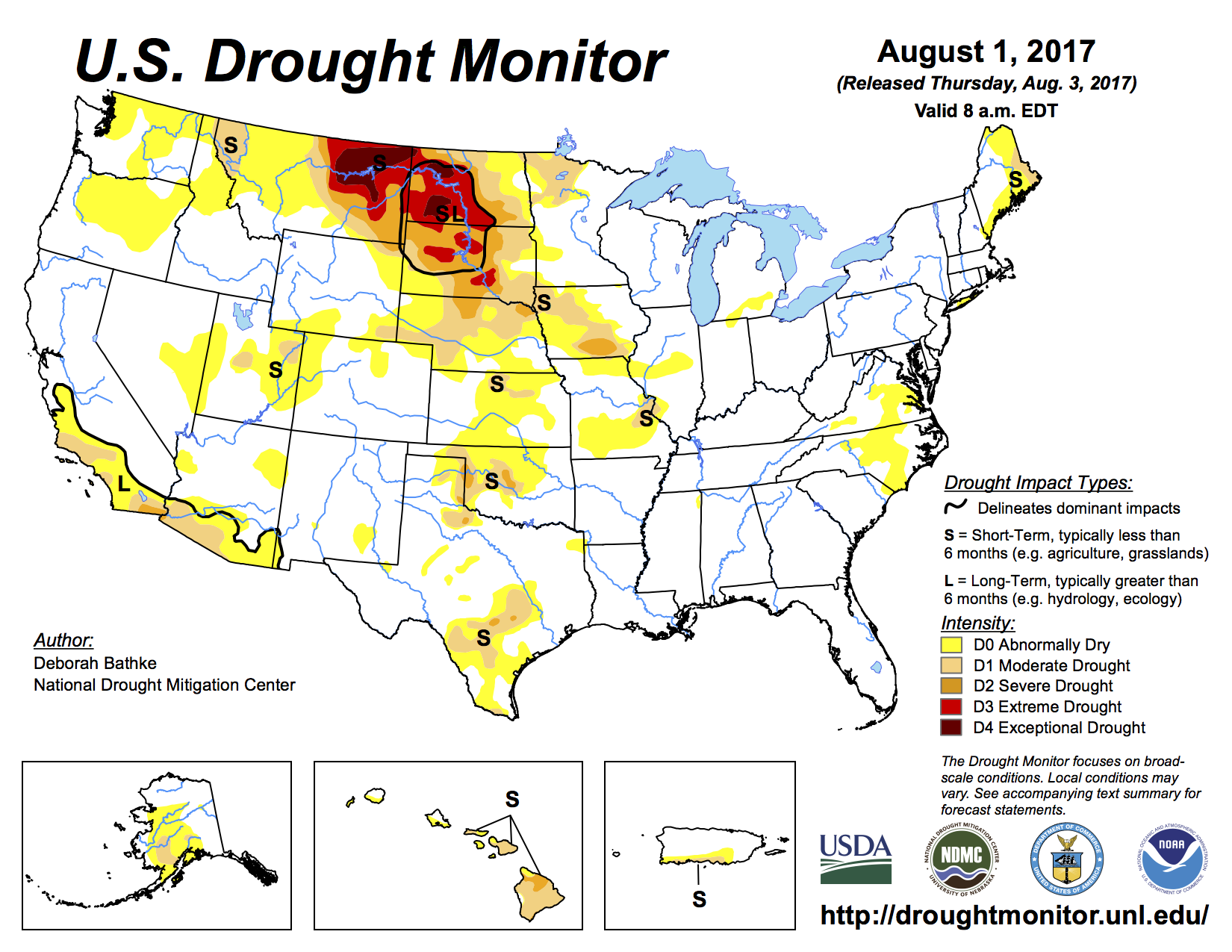
US Drought Monitor August 1, 2017.
Drought swept the northern Rockies
This year’s fires were fueled in part by severe drought. Exceptionally dry conditions in the northern Great Plains began in the spring and lasted into the fall, decimating crops in parts of Montana and the Dakotas. The drought also left many pastures unable to support cattle. Fields were so parched that many ranchers were forced to sell their animals or rely on donations of hay to get by.
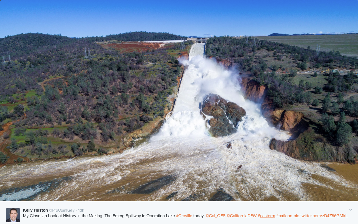
View of both spillways from just above the Feather River. Note the location of the catastrophic spillway failure center top of photo and the new channel to the right. Emergency spillway can be seen left of the failed spillway with the discharge coursing through the hillside to the left. Photo credit @ProComKelly.
California storms brought relief and ruin
California’s latest drought was declared largely over in early April. But the deluges of winter rain along the coast that helped end the dry spell also brought destruction. Tens of thousands of people in San Jose evacuated due to flooding in February, some of whom were still displaced months after the disaster. And more than 180,000 people downstream of Oroville Dam were told to flee their homes on Feb. 12, when officials feared that damage to the dam’s two spillways could lead to a catastrophic, uncontrolled release of water. Though the reservoir walls held, preventing widespread flooding, repairs to the spillways are expected to cost more than $640 million.
California’s heavy rains also set off several landslides. In Big Sur, a major bridge was damaged beyond repair in February and sections of Highway 1, California’s iconic coastal route, were obliterated, leaving some communities inaccessible by car. The biggest slide, on May 20, blanketed a quarter-mile of the highway and created a new, 15-acre peninsula jutting into the ocean.
Hail Wheat Ridge May 8, 2015. Photo credit TreeRootCO.
Colorado hailstorm smashed coffers
Rain wasn’t the only destructive weather that pummeled the West this year. On May 8, thunderstorms hit Denver, Colorado, and the surrounding area, walloping buildings and cars with hail the size of baseballs. More than 100,000 vehicles were damaged. The final price tag for the destruction wrought by the barrage was more than $1.5 billion, making it the state’s most expensive hailstorm ever.
Emily Benson is an editorial fellow at High Country News.
Please consider a donation or subscribing to The High Country News. Tell them Coyote Gulch sent you.
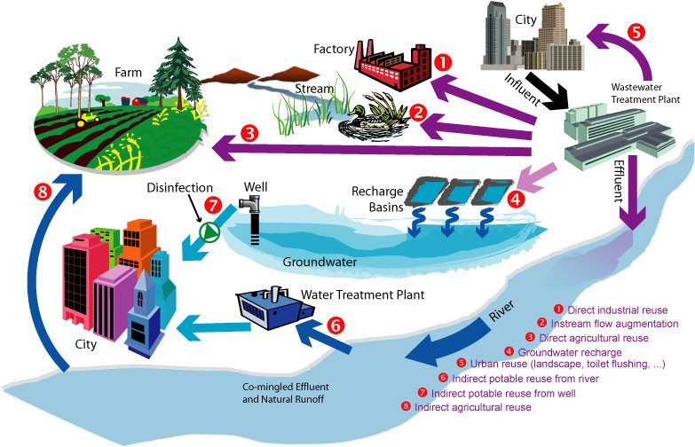
San Francisco is helping to grow adoption of onsite nonpotable water reuse systems by requiring them in large new buildings. Now there is interest in a statewide regulation to streamline permitting while ensuring health and safety.
IN DOWNTOWN SAN Francisco, a mixed-use 800ft tower nearing completion at 181 Fremont St. features a water treatment system that will provide 5,000 gallons a day of recycled water captured from the building to be used for toilet flushing and irrigation. That will help save an estimated 1.3 million gallons of potable water a year.
Just down the street, the recently expanded Moscone Conference Center has installed a system to collect and treat foundation drainage, otherwise known as “nuisance groundwater,” that will be used for toilet flushing and irrigation as well by the city’s Department of Public Works for street cleaning.
Both buildings are among 82 proposed or completed projects in San Francisco that are using decentralized, onsite water-recycling systems to capture and reuse water that would otherwise flow down the drain or run off rooftops to city sewers or into the San Francisco Bay. The treated water that’s captured isn’t used for drinking, but for nonpotable purposes such as flushing toilets and urinals, irrigating landscapes, supplying cooling systems and even generating steam power. In commercial buildings, about 95 percent of water used is generally for nonpotable purposes. In multifamily residential buildings, it’s 50 percent.
As interest in recycled water grows in California and across the United States, more building professionals are considering these decentralized systems. Up until now, a lack of health and safety regulations at the national and state levels has made the permitting process tricky and slow going. But bottom-up pressure may help create needed regulations…
This process would be easier for communities if there were established health and safety standards from the state for onsite nonpotable reuse, but so far they’re lacking.
“We think that from our perspective, if there is clear guidance and regulations that the state establishes, it would make it easier for communities that want to pursue local programs to oversee and manage decentralized water systems,” said Kyle Pickett, managing principal at Urban Fabrick.
Those regulations could be on the way, but how long it will take is unclear…
While there are no national or state regulations for onsite nonpotable reuse yet, there is a growing community of professionals sharing resources and expertise. SFPUC’s Kehoe chairs a National Blue Ribbon Commission for Onsite Nonpotable Water Systems, which recently produced a guidebook on water quality standards and management of onsite reuse systems. The commission was established by the U.S. Water Alliance, and it convenes more than 30 water and health professionals from across the country…
Other efforts are underway, too. Urban Fabrick’s nonprofit arm, the William J. Worthen Foundation, will be releasing a practice guide on January 19 aimed at giving design professionals information about onsite reuse…
“We don’t do nearly enough water recycling in California, honestly, it’s embarrassing how far behind we are compared to Australia, Israel and other places with very arid environments,” said Wiener. “We have a long-term structural water shortage and we need to modernize our water system and drag it out of the 1850s. Water recycling is a critical aspect of modernizing our water system.”