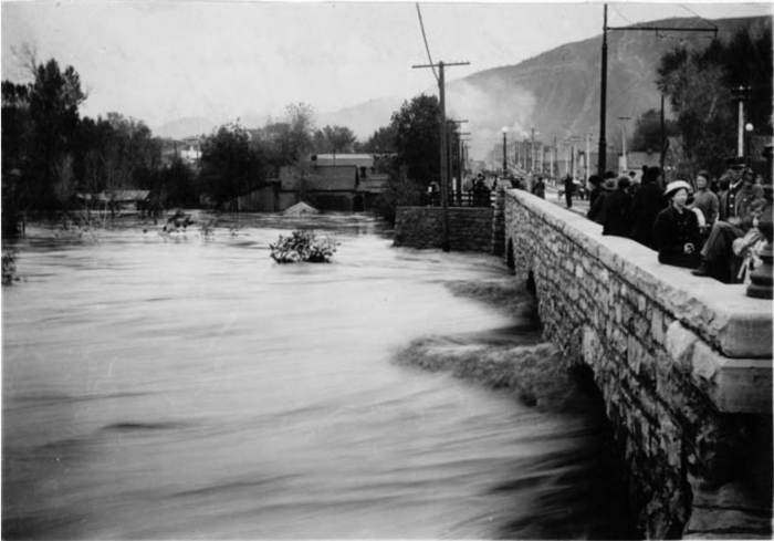
The National Weather Service on Saturday issued flood advisories for the Mancos, Animas and La Plata rivers, and residents reported flooding along the Dolores River about 10 miles north of town.
“We have major flooding on Road 37, Dolores, 10 miles north of Dolores,” Jeffrey L. Jahraus told The Journal. Eight to 10 properties were getting water, he said.
The flooding began Tuesday and has continued intermittently, Jahraus said. About a half-acre of his neighbor’s property was under water.
Flooding has happened at their property once or twice before, he said, but never like this. The Jahrauses live along Road 37, right by where the now-famous rock slide happened on Memorial Day Weekend…
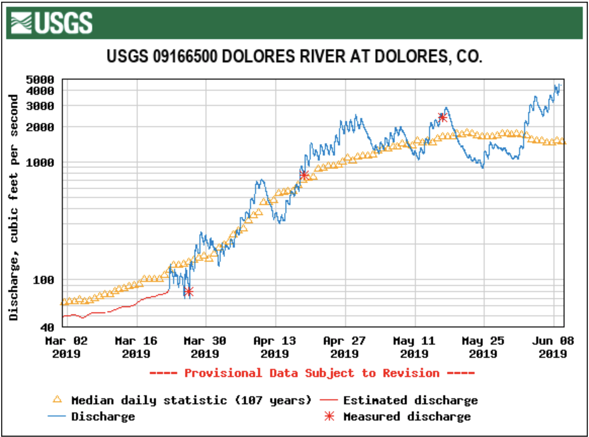
At the gauge in Dolores, the river was flowing Saturday morning at 4,200 cubic feet per second, about 256% the average June 8 rate of 1,604 cfs. Saturday afternoon, it reached 6.7 feet at the gauge, more that a foot shy of the 8-foot flood stage…
Meanwhile, flood advisories continued Saturday until further notice for the Mancos, Animas and La Plata rivers.
Mancos River
The river flow along the Mancos River was expected to remain near to slightly above bankfull, and minor lowland flooding was possible. Saturday morning, the river was at 5.3 feet – several inches above bankfull – and flood stage was at 6 feet. The river was expected to rise to about 5.4 feet around midnight Sunday.
La Plata River
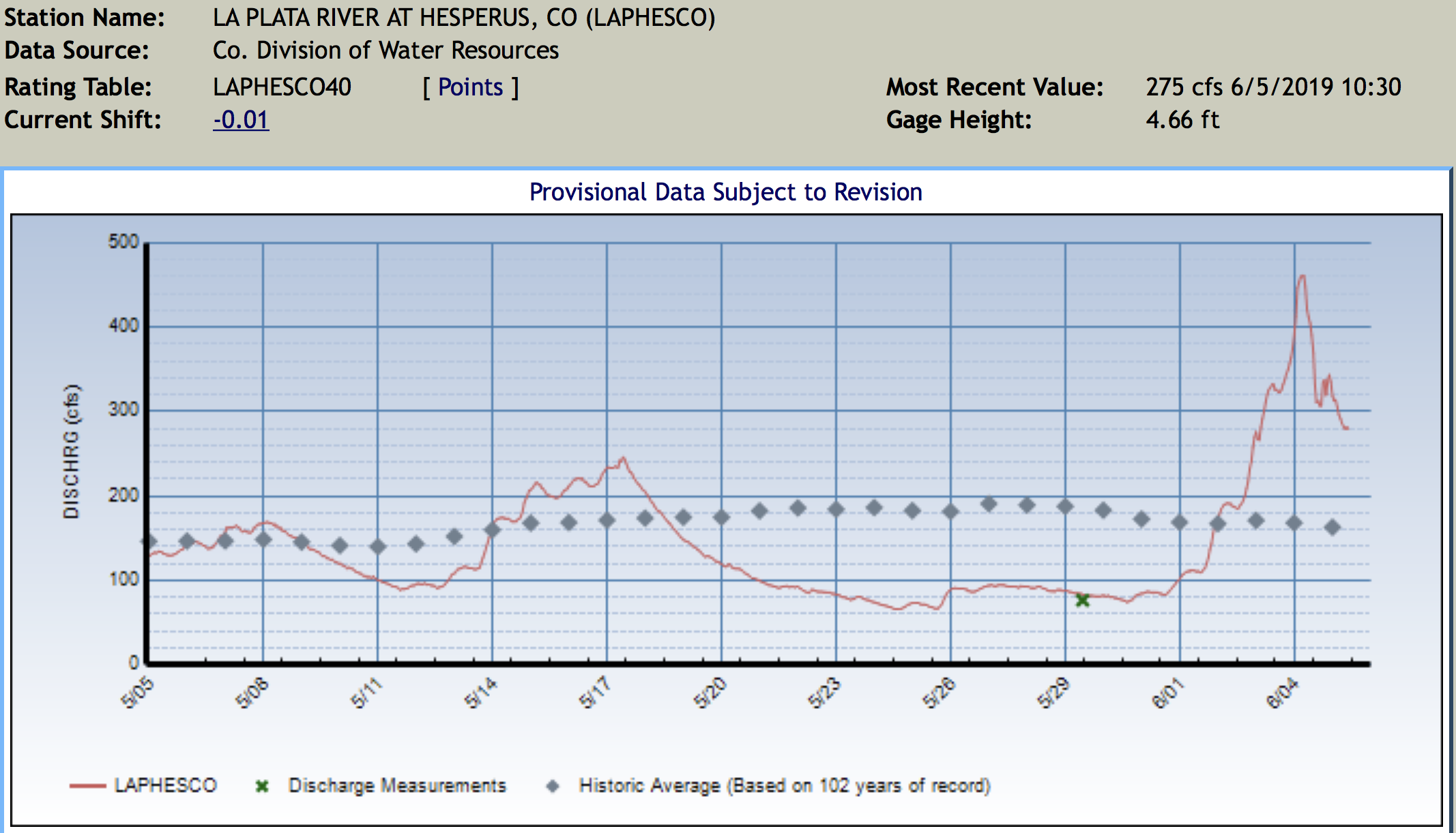
A flood advisory also continued Saturday for the La Plata River at Hesperus. The flows along the La Plata River were expected to remain slightly above bankfull, and flooding is possible, the National Weather Service said. Bankfull stage is 5 feet, and flood stage is 5.5 feet. Saturday morning, the river was at 5.1 feet and expected to rise to nearly 5.3 feet by Monday morning.
Animas River
The Animas River was flowing Saturday at 6.6 feet. The National Weather Service said the river was expectd to reach 6.93 feet by Sunday morning, a foot shy of the flood stage of 8 feet. Moderate flooding would occur at 9 feet, and major flooding at 10.5 feet. The record height of the Animas is 11 feet, the weather service says.
San Juan River Basin. Graphic credit Wikipedia.
From the Brigham Young University The Daily Universe (Josh Carter):
Lake Powell is benefitting considerably from this year’s runoff following a strong snow year in the Rocky Mountains. The lake has risen 16 feet in the last month and is experiencing an inflow of 128% the average. While water levels are expected to continue to rise until the peak month of July, there is still a long way to go before the lake reaches full capacity.
“This year definitely helps,” said Bureau of Reclamation Public Affairs Officer Marlon Duke.
“But people need to keep in mind that when we came into this season Lake Powell was about 140 feet low. Even after this year, we’re going to be about 100 feet below full pool. So what we really need is three or four years just like this in a row.”
Lake Powell is currently stuck in the worst drought of its 56-year history. Its water levels and inflow have dropped significantly since the summer of 1999 — the last time Lake Powell was essentially full at 97% of capacity. The lake hit an all-time low in 2005 when its elevation sank to 3,555 feet, 145 feet below full pool.
The lake did experience a spike during the summer of 2010, when its levels got within 40 feet of full capacity. The drought has since continued, however, affecting not only Lake Powell but its sister reservoir Lake Mead as well.
“In 2000, when the drought started, Lake Powell and Lake Mead were both full,” Duke said. “Today Lake Powell is about 42% full and Lake Mead is even lower than that. Before we can start talking about whether or not the drought is over we need those reservoirs to be full again.”
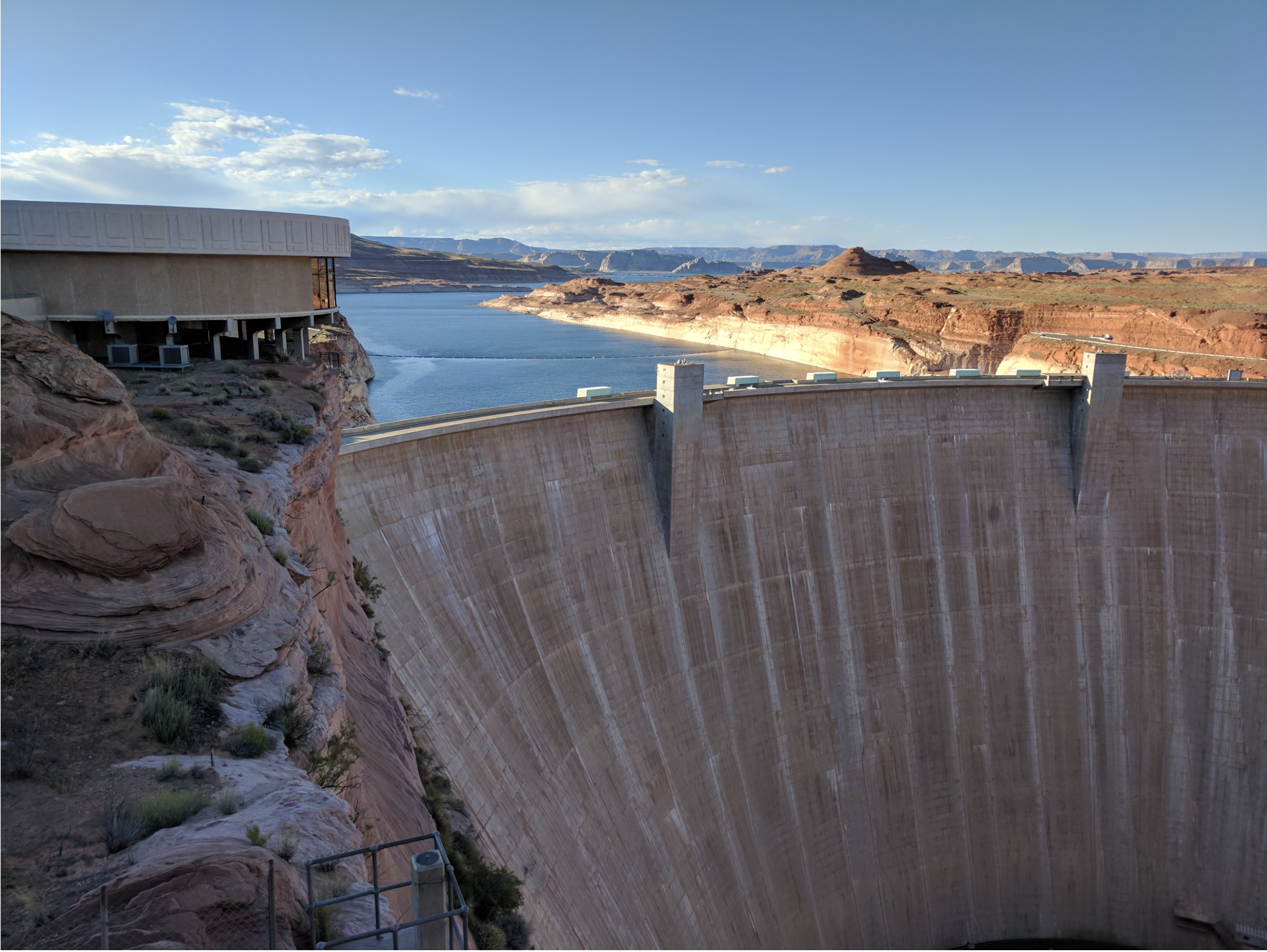
Lake Mead was formed in 1935 and Lake Powell in 1963 after the completion of the Hoover and Glen Canyon dams, respectively, along the Colorado River. They were created in hopes to store and provide water for the Colorado River Basin states during times of drought. Lake Powell predominately serves the Upper Basin states of Utah, Colorado, Wyoming and New Mexico, while Lake Mead provides for the Lower Basin states of Arizona, Nevada and Southern California.
The Glen Canyon Dam was completed in 1963 and subsequently caused the formation of Lake Powell. Photo credit: Esri Photo Library/Flickr via Brigham Young University
While both man-made reservoirs have served their purpose throughout the current drought, experts are thankful for this year’s runoff after a particularly low year in 2018.
“We’re coming off of 2018 which was the second-driest year ever since we’ve been keeping records in the Basin,” Duke said. “We were worried because if we had another year like 2018 then that would have really put us in some trouble.”
The drought hasn’t been the only threat to the lake’s water levels in recent years. A couple different proposals and campaigns are calling for Lake Powell to be drained and to distribute its water to Lake Mead and elsewhere.
“Fill Mead First” is a campaign first started in 1996 to encourage conversation about restoring the dammed Glen Canyon to its natural state. As the drought continued, the campaign has gained traction, arguing that Lake Mead needs more water from Lake Powell to ensure big cities such as Las Vegas, Phoenix, Los Angeles and San Diego have enough. The campaign also argues that Lake Powell loses water through both rapid evaporation and water seeping into the porous sandstone walls.
BYU geology professor Gregory Carling talked about the potential benefits that could come from restoring Glen Canyon to what it once was.
“When the Glen Canyon Dam was built, it not only flooded one of the most beautiful canyons in the world but also thousands of archeological sites and side canyons,” Carling said. “Also, the way it is now with Lake Powell and Lake Mead half-full, both are losing lots of water through evaporation. So there probably is some sense in looking into what the benefits would be of draining Lake Powell and filling Lake Mead.”
Carling added, however, the proposal would have to go through a lengthy legislative process in order for anything to change.
“There are a lot of legal requirements and bureaucracy behind that, so it’s not just as easy as saying, ‘let’s drain one and fill up the other,’” Carling said. “You’d have to go back through a hundred years of the law of the river.”
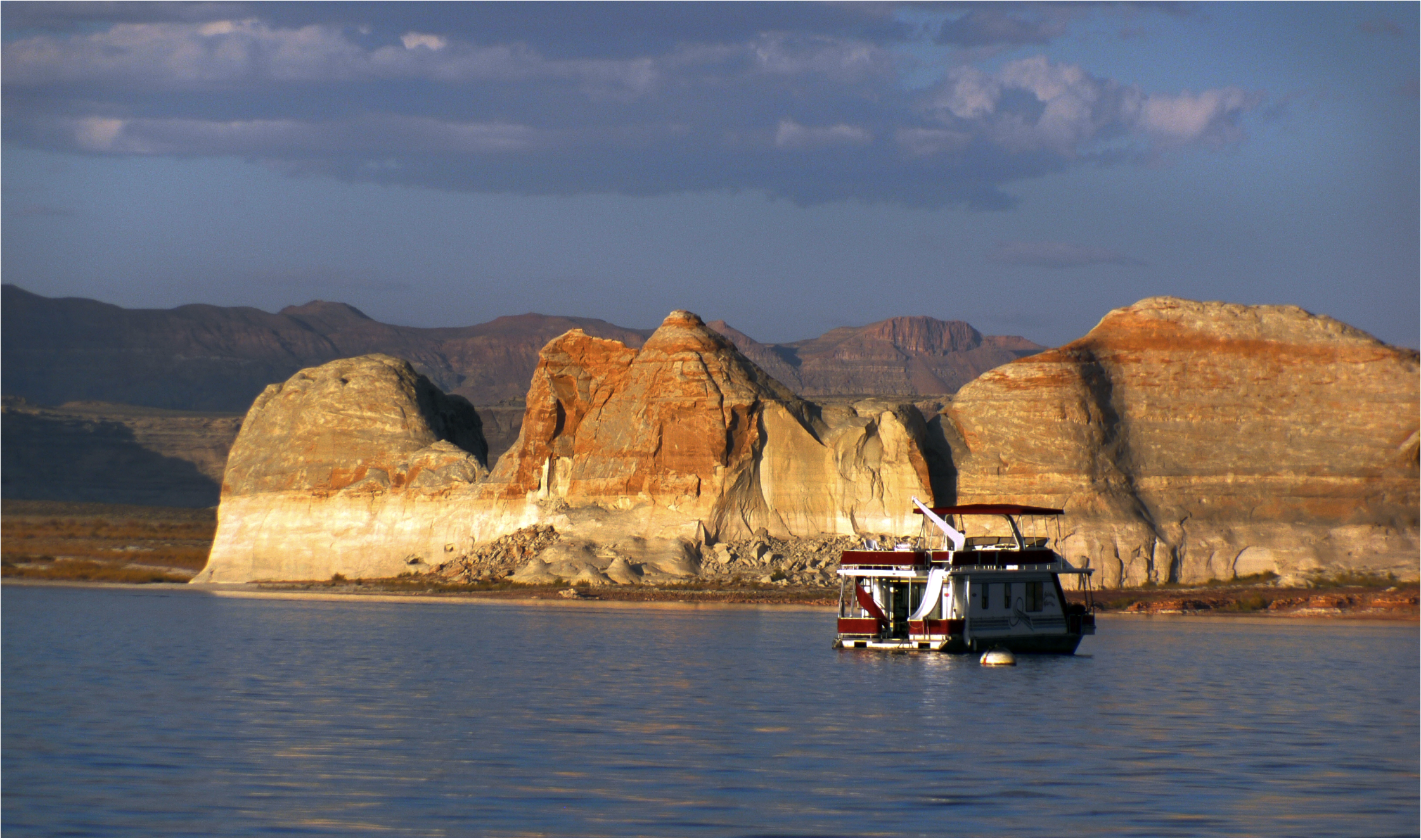
Those opposing the “Fill Mead First” campaign argue that Lake Powell, one of the most popular boating and camping spots in Utah, supports the local economy through both recreation and tourism. The lake saw over 4 million visitors during each of the past two years for the first time in its history. Lake Powell supporters also argue the lake ensures a steady water supply to Lake Mead and the Lower Basin states.
Lake Powell attracts millions of boaters and tourists every year. Photo credit:Bernard Spragg/Flickr via Brigham Young University
The Lake Powell Pipeline is another proposal aimed at transferring water from Lake Powell to nearby Kane and Washington Counties in southern Utah. The proposed pipeline would run approximately 140 miles underground and deliver over 82,000 acre-feet of water per year to Washington County and 4,000 acre-feet of water per year to Kane County.
The proposal did take a hit last year when the Federal Energy Regulatory Commission ruled it would need greater oversight from other federal land agencies such as the Bureau of Land Management, the Bureau of Reclamation and the National Park Service. Officials expect a final decision to be made on the project by 2020.
Even amid the recent controversies experts hope the Colorado River Basin can take full advantage of its water resources, especially in times of drought. Representatives from all seven Colorado River Basin states recently met to sign drought contingency plans for the Upper and Lower Basins.
“This brings us one step closer to supporting agriculture and protecting the water supplies for 40 million people in the United States and Mexico,” said Bureau of Reclamation Commissioner Brenda Burman. “Working together remains the best approach for all those who rely on the Colorado River.”
“The City of Farmington has temporarily closed sections of trails in Berg Park due to rising water levels.” City spokesperson Georgette Allen said in a press release June 7. “Trails on the north side of the Animas River near the All Veterans Memorial Plaza will be closed throughout the weekend.”
Perfluorinated compounds, commonly known as PFAS, turned up in levels exceeding recommended federal standards in the aquifer underneath the Air Guard base, said the consultant’s report.
But while the contamination appears to be moving toward city drinking wells on Tucson’s south side, the pollution doesn’t pose any immediate health risk to water users, Tucson Water officials say…
That’s because PFAS pollution already detected on the south side is being routed to a treatment plant that’s cleaning it up, and because the city drinking wells nearest the Air Guard base already are shut down.
The newly discovered contamination was widespread, tainting eight monitoring wells across the base and at least one more well at the base’s northern boundary, the report found. Sampling for the report was done from January through March 2018…
The pollutant concentrations ranged from nearly 70 times the EPA’s recommended health advisory level at a well at the base’s northern boundary, to just above the EPA advisory farther south on the base, said the report.
Another monitoring well contained about 30 times the EPA health advisory level of 70 parts per trillion, the consultant’s study found…
Measurable levels of PFAS compounds turned up in soil samples collected on 14 locations on the Guard base, but exceeded recommended health limits only at one of those locations, the report said…
At the same time, Tucson Water officials note that the nearest city wells, lying 1.5 to 2.7 miles northwest of the base, are already out of service because of previously discovered contamination from PFAS, trichloroethylene and 1,4-dioxane.
Polluted water from those wells is being funneled to a south-side treatment plant known as the Tucson Airport Remediation Project.
There, it’s being treated so thoroughly that the compounds are no longer detected as the water leaves the plant to be served to people in the downtown area and just north and south of there…
The ADEQ said it doesn’t have the legal authority to require the Guard base to clean up the contamination on its site.
That’s because the EPA has no formal drinking water limit for PFAS compounds and because Arizona law doesn’t allow the state to have more stringent environmental regulations than the federal government has.
FromThe Glenwood Springs Post Independent (Thomas Phippen):
“What a difference a year makes,” Zane Kessler of the Colorado River District said at the State of the Rivers meeting in Carbondale Thursday, comparing current snowpack averages to last year.
But as Kessler pointed out, 134 percent of average is only 34 percent better than average, and one good year doesn’t change the rising temperatures or the facts of living in the west, or the southwestern states that rely on Colorado River water are using more and more water.
The high snowpack will translate to fuller rivers and reservoirs, but it won’t solve the larger issues of what happens during the next low-precipitation year.
“One thing we noticed this year … is that our soil moisture was horribly low. So a lot of the moisture that came in the early part of this season, went to restoring those soils, and a lot of the water was sucked up,” Kessler said.
More water is being used up as temperatures rise, and both natural forests and agriculture lands have longer growing seasons.
This year, however, the biggest reservoirs in the region “are all expected to fill,” Alan Martellaro, division engineer with the Department of Water Resources, said at the meeting Thursday.
With the exception of [Granby] Reservoir, “the rest are expected to fill and spill. Hopefully, not spill,” Martellaro said.
As the weather warms and more snow melts, there is a risk of flooding on the Crystal River near Carbondale and near the Fryingpan River in Basalt.
The Crystal River “definitely will be above-bank full” at the peak flow for the year, which will likely be weeks later than usual, Martellaro said.
The usual peak occurs by June 7, but this year it will likely be between June 12 and 25, Martellaro said. The peak is also projected to last for weeks instead of days.
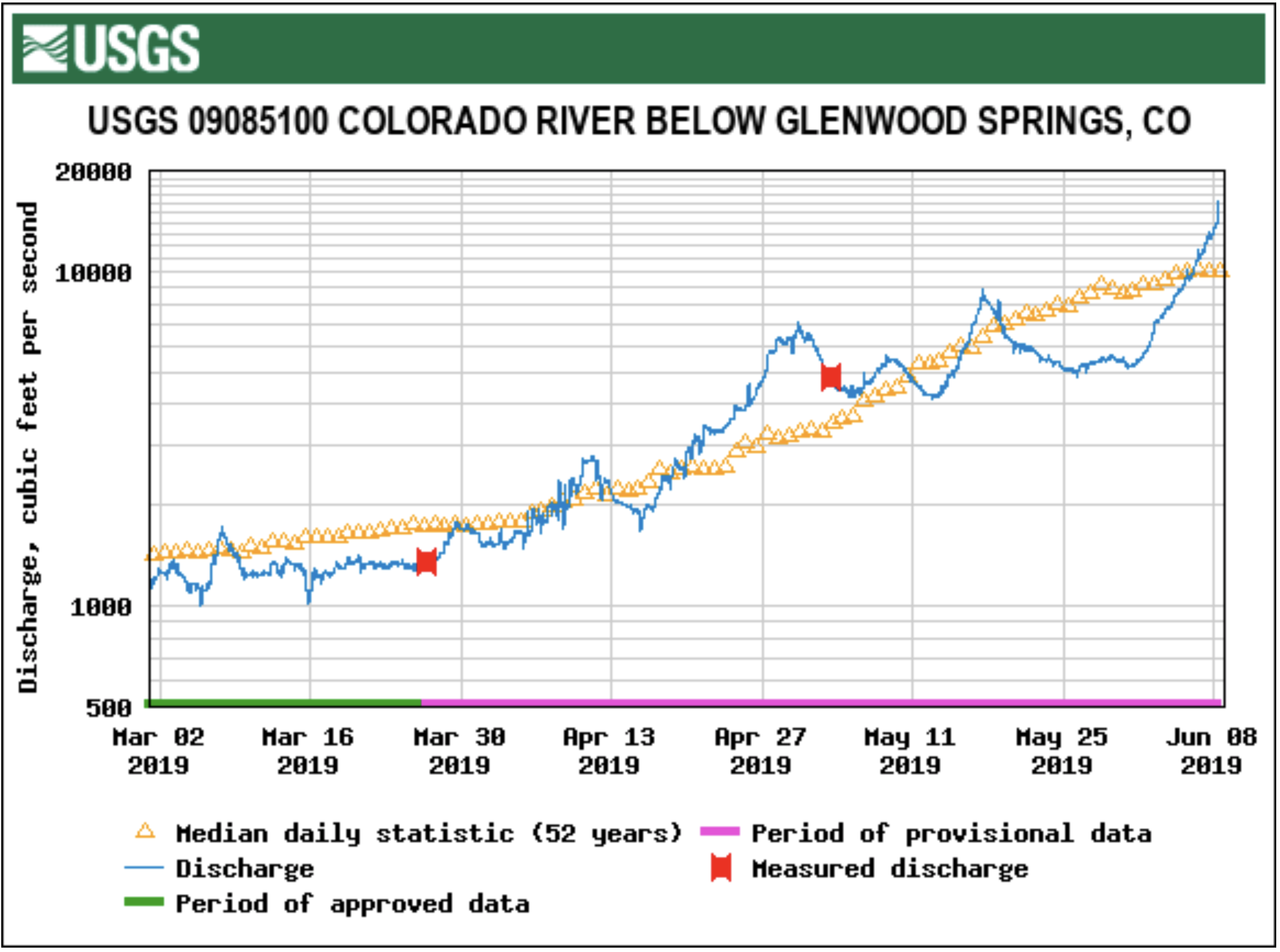
While snowpack is well above last year’s average and historical averages, river flows for many rivers only exceeded historical averages this week. The Colorado River just below Glenwood Springs reached 12,700 cubic feet per second Friday, above the historic median peak of 11,200 cfs, according to the USGS…
Another likely flooding area is on the Roaring Fork River just after the confluence with the Fryingpan in Basalt, Lewin said. The park was designed in part to allow the river to overflow there, she said.
From the Associated Press via Colorado Public Radio:
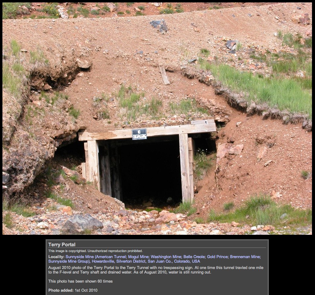
The EPA said it will drill into the American Tunnel next month to measure water levels and investigate how the passage is connected to other shafts.
The agency is looking for ways to stop or treat contaminated water pouring into rivers from old mine sites in the Bonita Peak Superfund area north of Silverton…
The EPA said it would follow strict safety guidelines when drilling the test well into the American Tunnel.
On April 7, 2016, the Environmental Protection Agency proposed adding the “Bonita Peak Mining District” to the National Priorities List, making it eligible for Superfund. Forty-eight mine portals and tailings piles are “under consideration” to be included. The Gold King Mine will almost certainly be on the final list, as will the nearby American Tunnel. The Mayflower Mill #4 tailings repository, just outside Silverton, is another likely candidate, given that it appears to be leaching large quantities of metals into the Animas River. What Superfund will entail for the area beyond that, and when the actual cleanup will begin, remains unclear. Eric Baker
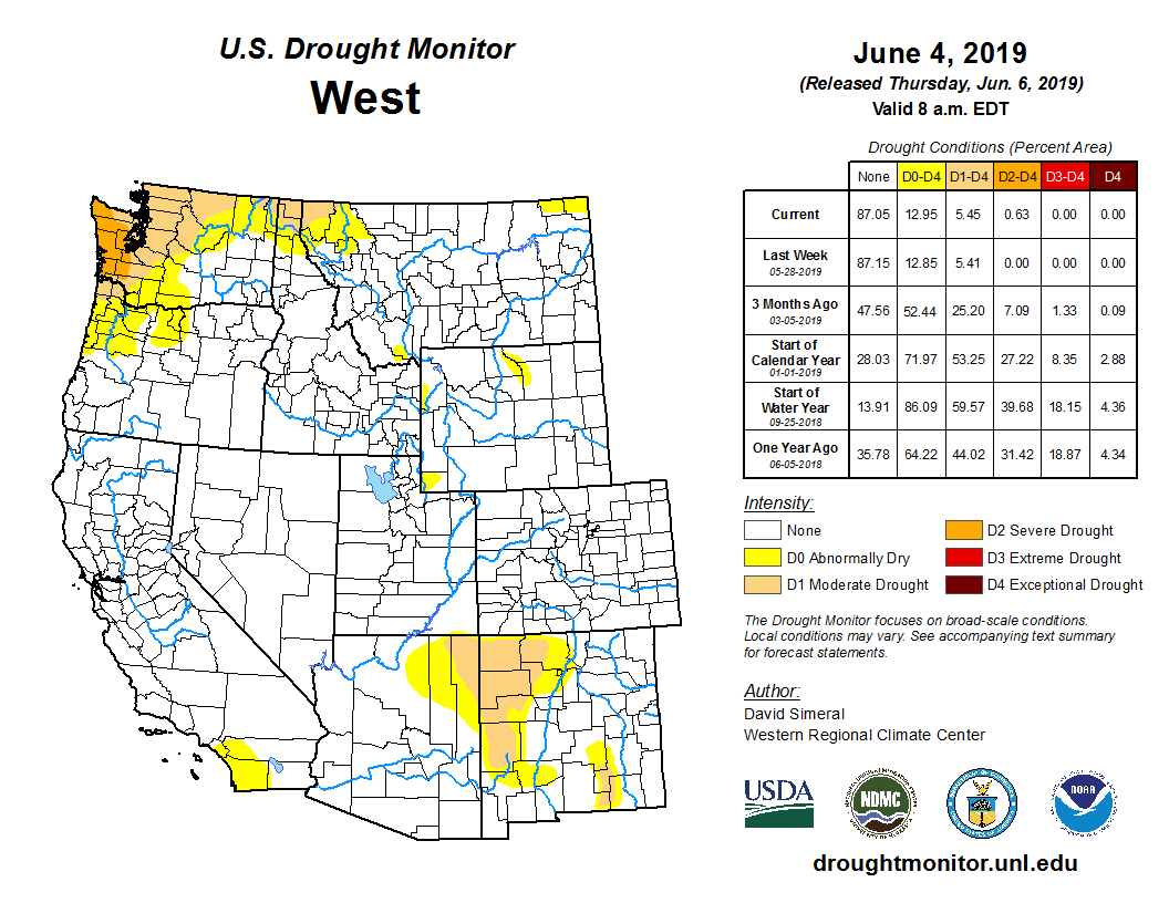
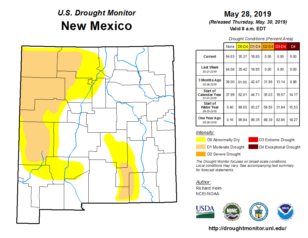
The U.S. Drought Monitor recently reported that, for the first time in its nearly 20-year history, none of the contiguous states was showing symptoms of severe or exceptional drought. That report includes Arizona, as this year’s abnormally wet May helped push the state out of a 10-year drought period.
According to the monitor’s weekly report for late last week, only 20.5% of Arizona was showing moderate drought or “abnormally dry” symptoms. Data for the same week in 2018 found 100% of the state in moderate drought or abnormally dry, with a majority of the state experiencing severe (97 percent) or extreme drought (73.2 percent).
Richard Heim, a meteorologist with the National Oceanic and Atmospheric Administration’s National Centers for Environmental Information, said the change was tied to this year’s wet spring.
“Rain and snow have been falling in the areas that needed it, so the drought’s contracted a lot,” he said.
State climatologist Nancy Selover said the increased rain and snow came from winter storms over the Southwest that lingered longer and provided more moisture than in the past.
“Typically, that pattern stops in April, if we even get it,” Selover said. “Last year it was so dry, we never even got that pattern. … So it was really warmer than normal, really drier than normal. This year, we had what I would consider a more normal pattern.”
Heim said this kind of shift in drought status is normal for the desert. Although the U.S. Drought Monitor has been collecting data on drought since 2000, he said, such records as the Palmer Drought Index, with recorded data from as far back as the early 1900s, indicate that drought in Arizona ebbs and flows regularly.
Selover noted that the Drought Monitor’s map only reflects short-term drought, not long-term.
“In the western U.S., water resources is a long-term issue,” she said. “Reservoirs don’t fill in a year and aquifers don’t drain in a year or fill in a year. It takes multiple years that are dry or that are wet in order to change that.”
As the effects of a warming climate intensify and a sense of impending catastrophe grows stronger, it’s becoming easier to give in to environmental despair. Having spent the past five years studying the Arctic and traveling around Greenland, I feel the pull as well.
Glaciers and sea ice are melting at an alarming rate; temperatures are rising at a steady clip. To make matters worse, the Trump administration’s recent efforts to ignore a fact-based, scientific approach — rejecting, for instance, the use of computer projections to assess how a warming world might look after 2040 — leads me to worry that climate denialism is moving from the scientific fringes to the institutional center.
Still, it’s worth considering that things may not be as bad as they appear. I say this with a full understanding that most indicators are pointing in the wrong direction. Yet I also feel we’re in danger of losing sight of two crucial and encouraging aspects of our predicament.
The first is the extraordinary value of the climate knowledge we’ve amassed over the past 100 years — a vast archive of data and wisdom that gives us a fine-grained understanding of how the planet is warming and how we can change the trajectory we’re on.
The second is the emergence of potential solutions, the products of a half-century of technological innovation, which may help us avert the worst impacts of the carbon dioxide and other greenhouse gases we continue to release into the atmosphere. (Last year carbon dioxide emissions were the highest ever recorded.)
Almost certainly, these tools, if used wisely, could keep global average temperatures from rising 3.6 degrees Fahrenheit, or 2 degrees Celsius, from a preindustrial baseline. Even lesser levels of warming are probably hazardous, but that temperature is the point beyond which many scientists believe the planet will suffer irreversible impacts from extreme and dangerous warming.
Recently, the entrepreneur and technologist Saul Griffith undertook a study of energy consumption for the Department of Energy and concluded that, using the United States as an example, “decarbonization is not an unattainable ideal.” In fact, he surmised it would be far easier than one might think, given our wealth and technological know-how.
We don’t need to assume an attitude of fear and dread. Our scientific progress is a story of technological optimism, defined by an extraordinary sense of capability. It shows what might be built and gained in the coming decades, and not merely what could be lost.
First, let’s consider this: For all the terror and gloom that global warming portends, its discovery is one of the greatest achievements of modern science. Technology can now tell us everything from how many tons of ice were shed by the glaciers in Greenland over the past few years to how many millimeters the oceans rose. Indeed, almost every fact or idea that informs the climate debate, from the number of endangered species to the dangers of melting permafrost, results from countless scientists and engineers, working in the field and in laboratories, over the course of a century.
This knowledge derives not only from heroic human expeditions to tropics, oceans, icecaps and deserts, but also from exquisite orbiting satellites that constantly scrutinize natural systems and human impacts on those systems. We know how much we have to fix on this planet, because we’ve figured out how to measure just about everything.
In the past few years, some commentators have warned that modern society’s faith in technology has led to a mistaken belief that it will save the world. They embrace solutions that encourage widespread behavioral changes, like consuming less, traveling infrequently and adopting a plant-based diet. We’re likely to need both technological and personal transformations. But in the end, it’s technology that will save us, not only because it can but also because it will have to.
In many respects, technology is saving us already: by identifying the magnitude of the threat, providing the extraordinary computing power required to run climate models to predict the future, and enabling architects and engineers to design for resilience against tempestuous storms and encroaching seas.
Technology has made possible clean and efficient energy systems that wouldn’t have been achievable a few decades ago, including cheap solar panels, LED lighting and batteries for electric cars. We now have green buildings that reduce energy usage and an emerging class of solar cells known as perovskites that may greatly lower the costs of renewable energy, and we are developing techniques to produce concrete that absorbs carbon dioxide rather than emitting it.
There is even room for techno-skeptics. A movement for “natural climate solutions,” like planting vast forests and using agricultural methods that sequester carbon in the soil, will become increasingly important as technology in the form of “integrated assessment” computer models tells us how much this approach can mitigate warming trends.
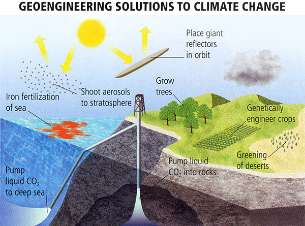
In the coming years, moreover, our ability to improve technology will determine the viability of carbon capture techniques to reduce atmospheric carbon dioxide and the value (or danger) of injecting aerosols into the atmosphere to shade the sun, cool the earth and provide more time for a clean-energy transition.
The range of hypothetical geoengineering ideas for the Arctic is equally audacious. One is to use wind power in winter to pump water from the depths of the Arctic Ocean to the surface to thicken sea ice so that it is more resistant to melting. Sea ice is critical to cooling the planet, because it reflects sunlight that would otherwise be absorbed by the ocean, heating it. (The downside of this idea, which underscores the scope of the problem, is that 10 million windmills would be needed.)
Another idea is to geoengineer glaciers in Greenland and Antarctica to delay their melting. For instance, a 100-meter-high wall could be built across the five-kilometer-wide fjord in front of the Jakobshavn glacier in western Greenland to block the warm ocean currents that have been melting it. The glacier has contributed more to sea level rise than any other glacier in the Northern Hemisphere, though recently, that has slowed. There’s no proof yet this plan would work, and it would be hugely expensive. But as the idea’s proponents pointed out in the journal Nature, sea walls and flood defenses already cost tens of billions of dollars a year to build and maintain. “At this price, geoengineering is competitive,” they argued.
So, as much as we may be asking whether technology will save us, that’s the wrong question. The right question is: How will we use our current technologies — and our potential to develop new and better ones — to save ourselves?
Adopting a measure of technological optimism is not the same as adopting the blithe and complacent outlook of a techno-utopian. Neither is it to assume that we won’t suffer in the coming years from heat waves, storms and floods — or from elected officials who disregard the urgent need for action.
Rather, it’s to view 20th-century history as an accumulation of hard-won knowledge that arose from using our wits to understand the climate. It’s also to see that important technological and engineering achievements — developing mass transit systems, huge wind farms, even nuclear power plants — are possible when we choose to act, especially through our politics and policies.
Proof of this can be found in the most unlikely places. For the past few years I’ve been tracing the history of scientific discovery on the imperiled Greenland ice sheet. Greenland’s ice is so thick and so old that scientists can drill down and extract samples that contain evidence of what the environment was like thousands of years ago. With the help of lab instruments, researchers can reconstruct ancient temperatures and atmospheric conditions.
Amid the trace chemicals that turn up in the old ice, there is an unmistakable fingerprint of lead from a few thousand years ago — traces from silver smelters in Europe, during the height of the Roman Empire, which released lead into the air that was deposited on the icy surface of Greenland. In more recent records, we can see vestiges of the metal from the fumes of the early years of the Industrial Revolution and, later still, the residue from leaded gasoline.
But by the early 1990s, these traces had receded from Greenland’s snow and ice. That was after new regulations and new products — created over the opposition, incidentally, of fossil-fuel concerns — eliminated the lead that was poisoning us from gasoline.
And life went on as usual.
Think of that the next time dread creeps in. Without question, reducing carbon dioxide is a far bigger challenge than reducing lead, and the stakes are much higher. But we now have a deeper well of knowledge and considerably better technologies. Indeed, if we don’t deploy the resources we now wield, many years into the future our story of failure will simply be this: We understood the threat, we were very smart and exceedingly capable. We had money and we had tools. And we chose not to act.
Jon Gertner is the author of the forthcoming “The Ice at the End of the World.”
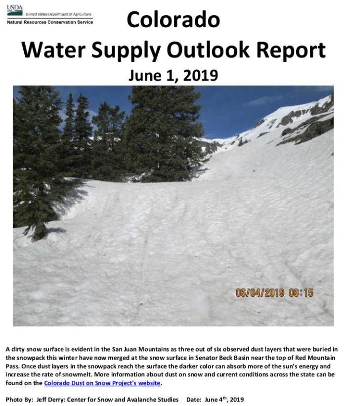
Here’s the release from the NRCS (Brian Domonkos):
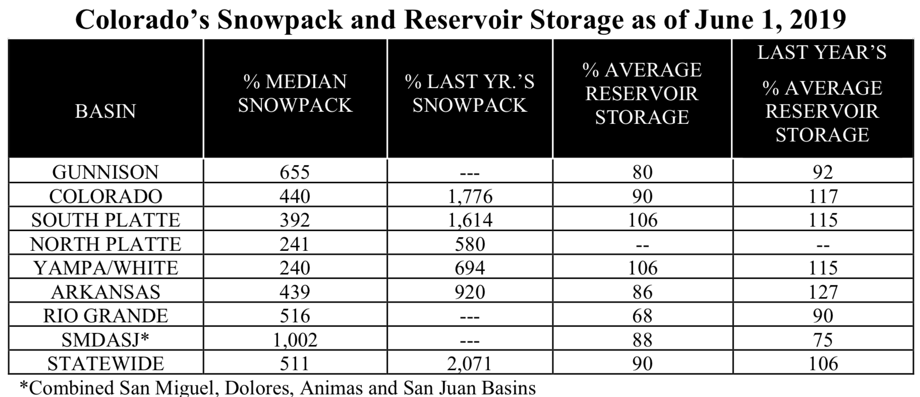
Spring and summer conditions are emerging slowly in Colorado’s high country. Highlighting one snapshot of these conditions, mountain snowpack monitoring stations across Colorado observed an average increase of 1.4 inches of snow water equivalent, equal to about one foot or more of snow depth, from one storm system during May 20th through the 24th. Spring storms such as these are generally normal and often occur twice during the snowmelt season, but usually come earlier in the spring. As of June 1, statewide snowpack stands at 511 percent of normal. The last time statewide snowpack was this high was in 2011 when conditions were much the same as this year. However when focusing in on the basin scale, most individual basins’ current snowpack most closely compares with 1995, particularly in the southern and western basins. In 1995 snowpack peaked higher compared to this year. This year snowpack peaked at 134% of statewide normal.
Statewide Basin High/Low graph June 6, 2019 via the NRCS.
“May was a particularly wet month, the second wettest month of the year at 174 percent of normal statewide This coupled with the cool temperatures have aided mountain snowpack to persist later than normal,” comments Brian Domonkos, Colorado Snow Survey Supervisor. In fact, this spring has exhibited one of the slowest snowmelt rates in many years. With May’s above normal statewide precipitation the year-to-date totals are now 124 percent of average, correspondingly all major basins in Colorado are above average. The combined Yampa, White & North Platte maintains the lowest percent of average in the state at 116. Reservoir storage remains generally low in anticipation of rising streamflows as rivers have yet to peak. “Below normal reservoir levels will help in absorbing above normal streamflows,” says Domonkos.
Since the snowpack peak in early to mid-April snowpack is nearly half melted according to SNOw TELemetery (SNOTEL) snowpack monitoring stations. With half of the snowpack remaining to melt, streamflows will rise as temperatures continue to warm. As this happens it is important to monitor weather, river levels and snowmelt rates.
This year’s snowpack is particularly high compared to last year and normal conditions, which are both relatively small. This disparity explains the relatively high percent of last year’s snowpack numbers such as in the Colorado, South Platte and Statewide snowpack values. Absent values in the table below are due to no snowpack present at this time last year.
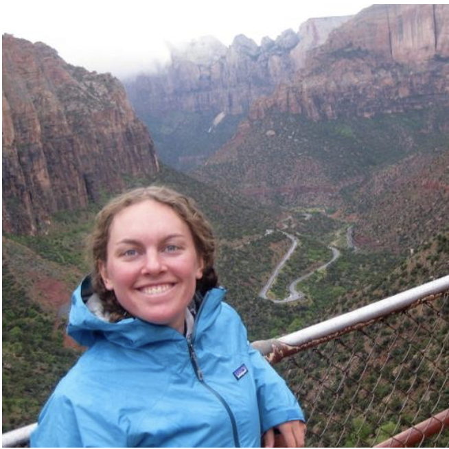
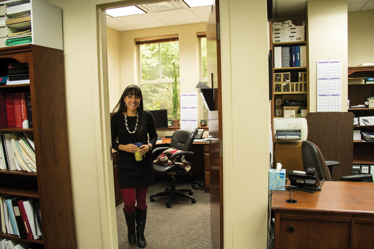
Kate Greenberg. Photo credit: National Young Farmers Coalition
Here’s a report from The Denver Post (Judith Kohler). Here’s an excerpt:
As state agriculture commissioner, Greenberg wants to travel to as many places as possible. She has also mapped out a set of four major priorities and relishes detailing them.
“Are you ready for the next one?” Greenberg asks as she dives into discussing her priorities. “Are you ready for No. 3? Are you ready for No. 4?”
The road Greenberg traveled to her new job as Colorado ag commissioner is different from most of her immediate predecessors, many of whom grew up farming and ranching. Greenberg did not.
Besides her background, Greenberg is different from her predecessors in an even more fundamental way. She is the first woman to hold the job in the state’s history.
Greenberg grew up in Minnesota, was around agriculture and had friends and neighbors who farmed and ranched. However, it wasn’t until she moved to eastern Washington state that she farmed and ranched herself. There and in western Washington, Greenberg raised vegetables and livestock on community-supported farms. While with the Sonoran Institute, Greenberg worked with communities on restoration projects and managed greenhouse operations.
Most recently, Greenberg was the Western Program Director for the National Young Farmers Coalition, working on water issues and based in Durango. She graduated from Whitman College in Walla Walla, Wash., with a degree in environmental studies-humanities.
“I’ve always loved and worked on behalf of the outdoors, natural world,” Greenberg said. “The piece that really shifted when I came West was realizing the work people put in behind the scenes…
She wants to ensure that agriculture remains vital by supporting the next generation of farmers and ranchers.
“We don’t have enough young people coming into agriculture, which means not only do we risk losing the legacy of the current generation, the assets, but also the land,” Greenberg said. “We are really at a fork in the road with the aging demographic overall of farmers, paired with the economics of farming right now.”
Agriculture contributes about $40 billion annually to the state’s economy, Greenberg said, making it the second-largest sector of the state’s economy.
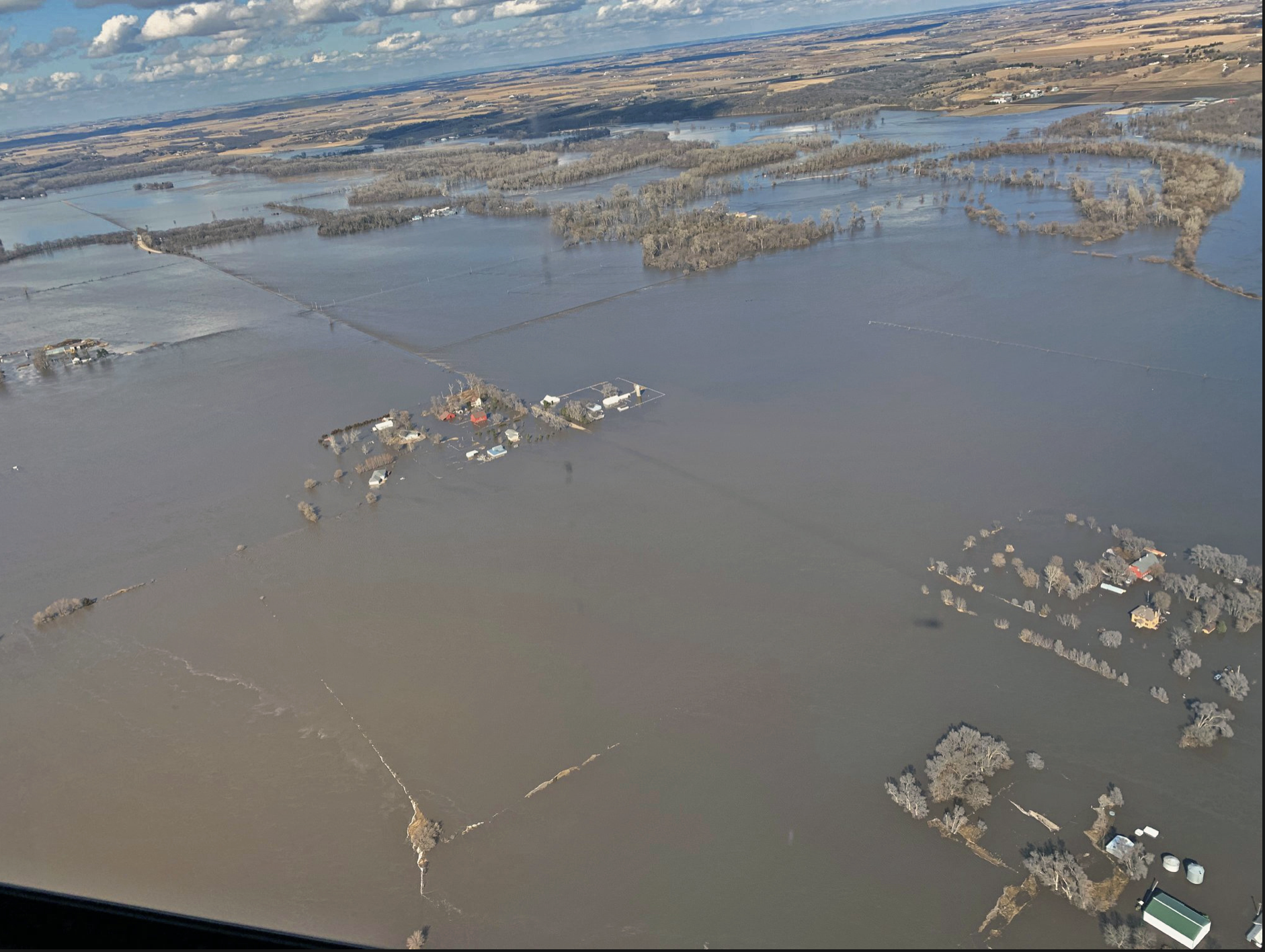
Photo courtesy of Nebraska Governor Pete Ricketts and Farm Aid
Here’s a report from the American Farm Bureau The Fence Post:
American producers have been hit hard in the past few years by hurricanes, floods, tornadoes, typhoons, volcanic activity, snowstorms and wildfires.
Farmers and ranchers in the South still are recovering from Hurricanes Michael and Florence, while producers in the Midwest are reeling from unprecedented flooding this spring.
Several Market Intel articles have reviewed recent disasters as well as the historical delays in planting this year. On June 3, the House passed a $19.1 billion disaster aid bill, H.R. 2157, that previously passed the Senate with overwhelming support. Now awaiting a presidential signature, this package includes more than $5.2 billion to assist USDA and related programs. The bill also includes funding for nutrition programs in Puerto Rico, American Samoa and the Northern Mariana Islands. This Market Intel highlights the agriculture-related provisions in the disaster aid package.
Farm Disaster Assistance
USDA was allotted $3.005 billion to assist with the loss of crops because of Hurricanes Michael and Florence, as well as other natural disasters occurring in the 2018 and 2019 calendar years. These crops and commodities include milk, on-farm stored commodities, crops prevented from planting in 2019, trees, bushes, vines and harvested adulterated wine grapes. Funding will be available until Dec. 31, 2020. A provision is also included for losses due to Tropical Storm Cindy, as well as losses of peach and blueberry crops from extreme cold and hurricane damage in 2017 and 2018. Orchardists and pecan tree growers may receive payments if their tree mortality rate is over 7.5% and below 15% (adjusted for normal mortality) in calendar year 2018.
Importantly, payments for crop insurance policies under the Federal Crop Insurance Act or the Noninsured Crop Disaster Assistance Program will cover up to 90% of the loss. Crops not covered under these programs can receive up to 70% of the loss. If a crop is offered a revenue insurance policy under the Federal Crop Insurance Corporation, the greater of the projected price or harvest price for that crop will be used to determine the expected value. (Note: There is widespread confusion among growers as to how this provision may relate to crops prevented from being planted, i.e., if prevent planting payments are made on 70% to 90% of the revenue guarantee it could influence planting decisions given the historic delays experienced in both corn and soybean plantings.)
If producers receive these payments, they are required to purchase crop insurance where it is available (under NAP if crop insurance coverage is not available) for the next two available crop years.
Finally, up to $7 million is provided for Whole Farm Revenue Protection indemnity payments that were reduced in 2018. This program provides a safety net for all commodities on a farm under one insurance policy.
Farm Service Agency Emergency Programs
To help owners of non-industrial private forests restore forest health, the Emergency Forest Restoration Program was allotted $480 million. In addition, the measure allocates $558 million for the Emergency Conservation Program, which helps farmers and ranchers recover damaged farmland and install methods for water conservation during a severe drought, and $435 million for Watershed Protection and Flood Prevention Practices to assist with rural watershed recovery.
Rural Development
The bill provides $150 million for Rural Development Community Facilities grants. These grants assist small rural communities in improving and repairing essential public services and facilities. However, these payments will not be applicable if the community is already receiving assistance from the Rural Community Advancement Program via the Rural Development Trust Fund, grants and guaranteed loans.
Market Facilitation Program AGI Waiver
As of May 13, the first round of trade aid provided $8.5 billion in market facilitation program payments to farmers and ranchers, Figure 1. One limiting factor, however, was that trade assistance was capped at $125,000 per operator and farmers with an adjusted gross income above $900,000 were not eligible for trade assistance.
The disaster relief bill amends this provision and waives the eligibility requirement with respect to adjusted gross income. A person or legal entity is now eligible to receive payments under the Market Facilitation Program if the average adjusted gross income exceeds $900,000 and more than 75% of the adjusted gross income comes from farming, ranching or forestry-related activities. Payment remains capped at $125,000 per operator.
Nutrition Assistance
The disaster bill includes provisions for disaster nutrition assistance in the Commonwealth of the Northern Mariana Islands, Puerto Rico and American Samoa. Assistance totals $643.2 million to these U.S. territories in response to major disasters or emergencies designated by the president.
Hemp Crop Insurance
The disaster aid package also included language offering coverage for hemp under the whole farm revenue protection insurance policy starting in the 2020 reinsurance year. The 2018 farm bill Provides A Path Forward for Industrial Hemp, but there was uncertainty about when hemp would be eligible for federal crop insurance.
Summary
The recently passed disaster relief bill provides emergency assistance to farmers dealing with the aftermath of natural disasters, as well as farmers impacted by late planting. Most of the agriculture-related funding — slightly more than $3 billion — is for farm disaster assistance related to hurricanes, floods, tornadoes, typhoons, volcanic activity, snowstorms and wildfires. Other funding is allocated for nutrition, conservation, forestry and watershed assistance programs.
This year, instead of supplying helicopters with water to dump on fires, Denver Water is draining water from Dillon Reservoir in anticipation of runoff, which is expected to really begin coming down in the next few weeks.
“This year being a high snowpack year, we know there’s going to be a lot of water getting into the reservoir,” Denver Water supply manager Nathan Elder said. “We’re trying to have enough space to catch that runoff while providing for safe outflows to the Blue River below the reservoir.”
[…]
At the moment, the reservoir — which is the main drinking water supply for 1.4 million people in the Denver metro area — is 75% full with 192,554 acre-feet of water. When full, the reservoir holds 257,304 acre-feet. An acre-foot of water would cover an area the size of an acre 1-foot deep. Given the current estimate for runoff volume, there will be more than enough water to fill it.
“The forecasting for the rest of June and July project a volume of anywhere from 169,000 acre-feet to 211,000 acre-feet coming into the reservoir,” Elder said. “That’ll fill it, but we’re probably not going to fill it until the Fourth of July to make sure we’re past that peak-inflow time.”
Elder said peak inflow to the reservoir is expected to start about a week later this year than usual, which also means Summit’s two marinas in Dillon and Frisco will have to wait before the reservoir is full enough for boating. However, boaters should have a lot more time for play this year compared with last, when boat ramps were retracted weeks before they normally would be due to low water.
“Typically, every year we target June 18 to be at 9,012-foot elevation needed for both marinas to be completely operational, but it’s going to be a little delayed this year,” Elder said. “But while the boating season might be shortened by a week on the front end, on the tail end, it should last quite a bit longer.”
The delay also means local emergency officials will be watching streamflows longer into the month, looking to spring into action if Tenmile Creek, Straight Creek or the Blue River approach the verge of flooding.
Current two-week projections show all three waterways approaching “action stage,” the threshold at which the towns and county are called to start flood mitigation preparations, by June 15.
Summit County’s director of emergency management Brian Bovaird said he closely has been watching the forecasts for flooding. That is opposed to last June when Bovaird, who recently had gotten the job as emergency director, was given a literal trial by fire.
“It’s like picking your poison,” Bovaird said. “Last year, it was wildfire. This year, it’s flooding. We’re expecting heavy runoff moisture, which is good for wildfire but makes us uneasy about the flooding risk.”
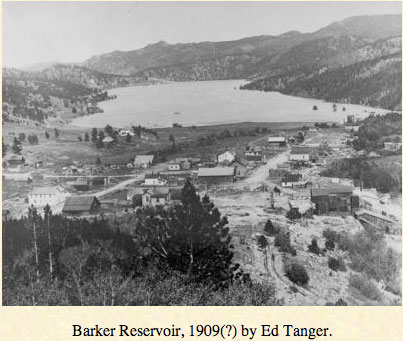
Barker Dam’s scheduled spill is expected to begin over the next few days, officials said. Each spring as temperatures warm, runoff from melting mountain snow increases stream flows. Before peak stream flows occur at lower elevations, like in the City of Boulder, mountain reservoirs must first fill and start spilling, officials said.
“This is a normal and expected event that will increase flows in Boulder Creek throughout the city,” The City of Boulder said in a statement.
The Barker Dam spill normally occurs between mid May to late June, but is dependent on weather, snowpack and early spring reservoir levels. This spring, cool temperatures and continued snow accumulation have delayed snowmelt runoff, the city said.
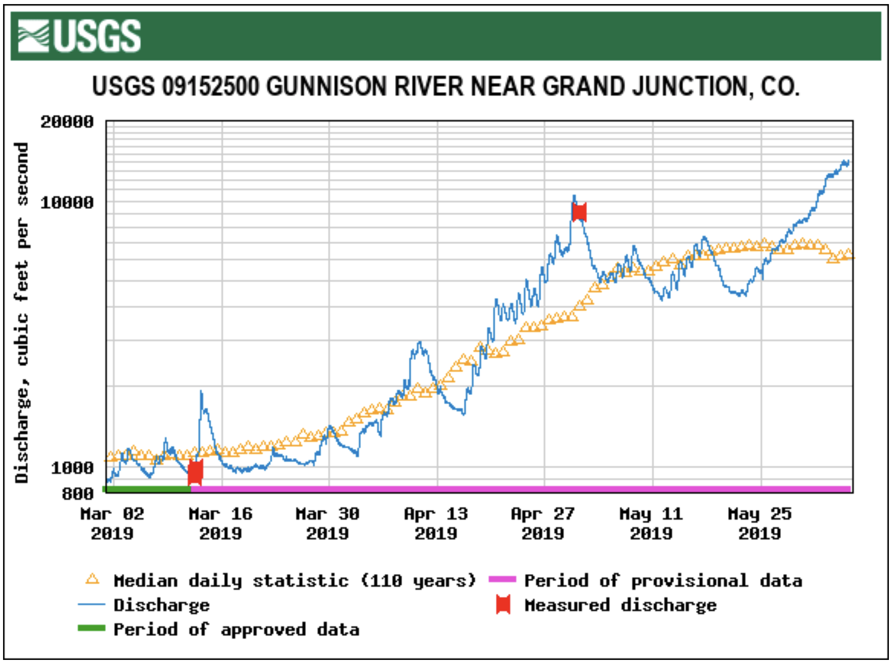
The waters of the Gunnison River are currently at 10.7 feet. It has passed the bankfull stage. This means some water is beginning to spill out into the floodplain. The floodplain is the low-lying area next to the river. The Gunnison’s Flood stage is at 13 feet. It’s expected to rise near 10.8 feet by Saturday.
Orchard Mesa and Whitewater are under the current advisory.
Parts of the Colorado River are rising, but it’s not under an advisory. The Colorado River near Loma is nearing bankfull. According to data from a National Weather Service gauge near the state line, water levels are at about 10.5 feet and are expected to rise to 12.5 by Saturday afternoon.
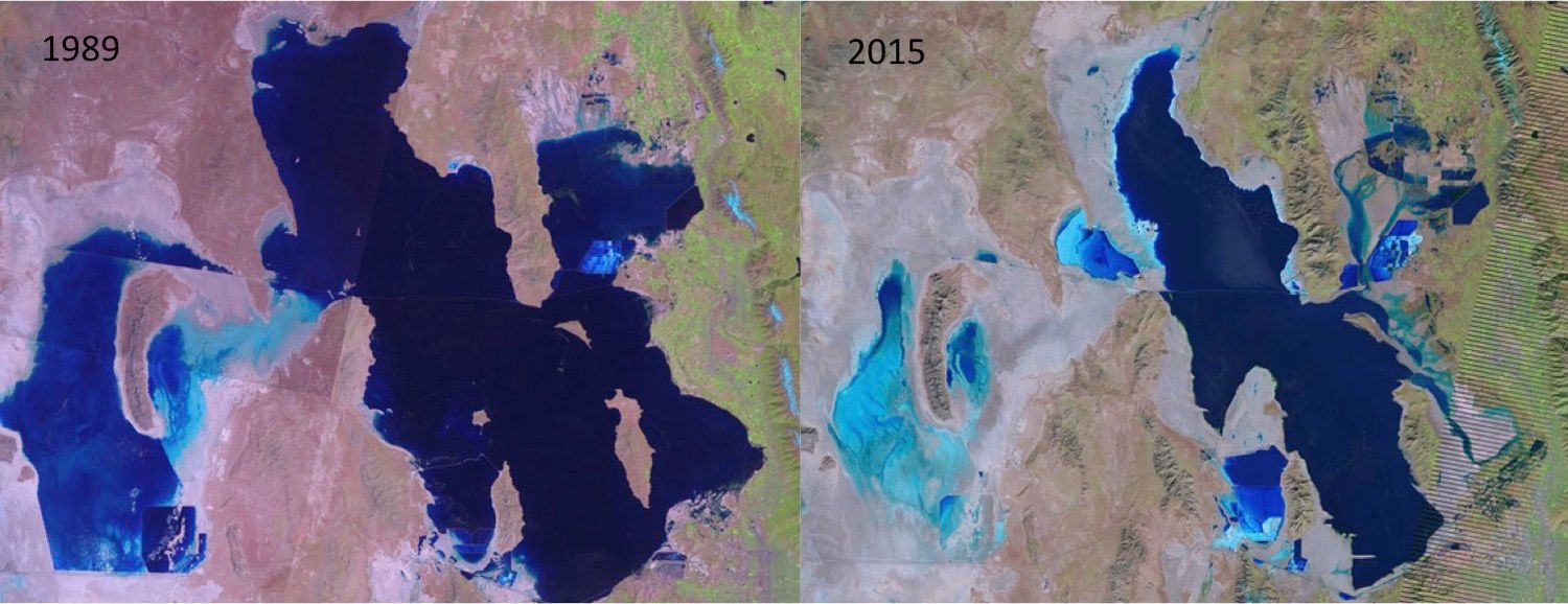
PHOTO CREDIT: McKenzie Skiles via USGS LandSat The Great Salt Lake has been shrinking as more people use water upstream.
The south arm of the Great Salt Lake is up by 2.5 feet since December and its north arm is 2 feet deeper thanks to the wet water year, and the Western Hemisphere’s largest saltwater lake will take on even more water in the weeks to come.
“It’s a pretty good jump so far, but we’re not done yet,” said Todd Adams, deputy director of the Utah Division of Water Resources.
The highest elevation snowpack has yet to melt, and with most reservoirs brimming, that water will bypass those storage infrastructures and help quench the thirsty saltwater body…
Water managers along the Wasatch Front will be keeping their eye on stream flows and reservoir levels to keep enough storage going into the summer and time releases into rivers to hopefully avoid flooding.
While most reservoirs are already full, Echo above East Canyon sits at just 49 percent of capacity and Rockport sits at 78 percent, ready to take on snowmelt.
“We could have filled it (Echo) twice this year,” said Tage Flint, general manager of the Weber Basin Water Conservancy District. “The peak flows have not occurred yet coming out of the Uinta Mountains coming down the Weber River, so we are purposefully leaving Rockport down some and Echo down more to use them as shock absorbers to take those big flows.”
Much of that extra water will be sent on downstream to the Great Salt Lake…
The lake is critical to wildlife, multiple industries, recreation interests and more, contributing $1.3 billion into Utah’s economy and drawing tourists from all over the globe.
It serves as the Pacific “flyway” for thousands of migratory birds and supports a $57 million brine shrimp industry…
Mike Styler, who recently retired as executive director of the Utah Department of Natural Resources, said maintaining the viability of the Great Salt Lake will be one of the critical challenges the state faces going into the future.
He stressed that as agricultural water gets converted for urban use in Weber and Davis counties and reuse of waste water becomes more popular, that threatens to dry up marshes and wetlands that support the lake.
The Great Salt Lake has an average depth of 16 feet, covers 1,700 square miles during an average year and is two to seven times saltier than the ocean.
Karen Guglielmone, the Town of Telluride’s environment and engineering division manager, presented the yearly water audit to Town Council in a Tuesday work session, which emphasized the importance of conservation, despite the town’s abundant water supply.
“We are a steward to our water resources,” she told council. “We are stewards for what we need now and into the future.”
The annual report has been produced since 2014, when the town adopted a Water Efficiency Plan, which was subsequently approved by the Colorado Water Conservation Board (CWCB) late that year. The annual report reveals figures such as overall municipal water use — and losses — and indicates trends that can help officials modify the plan.
Water losses are attributed to a number of factors including leaks, unauthorized consumption, faulty metering and data errors.
Leaks, Guglielmone explained, are common in municipal water systems as they age. One such leak occurred under East Columbia Avenue in 2018, which officials then said had likely been a progressive event due to pressure from a rock. Directly on the waterline. There are more of those, Guglielmone said.
“We can expect a slow increase of leaks over time,” she said. “We have others we can’t locate precisely.”
Despite the challenges of controlling losses, in 2018 the loss rate dipped by 13.5 percent when compared to the last five years of collecting data. Last year’s losses were calculated to be 26 million gallons, down from 2017’s 37 million gallons. Telluride’s losses are still high compared to other municipalities.
“We’re high on our water loss,” she said. “Fifteen percent is the goal, though 25-30 percent is more the reality,”
Residential water use is holding steady, according to the report. The fact that it stayed about the same (118 million gallons) is “pretty cool,” Guglielmone said…
Town Attorney Kevin Geiger noted that overall the town is in good shape as far as its supply is concerned.
“Our water portfolio is robust,” he said. “(Blue Lake) is a very large reservoir for our town. It is the envy of municipalities in Colorado.”
Telluride’s water rights are also strong…
Incorporating the Blue Lake reservoir and the Pandora water treatment plant became necessary when the town’s growth overtook what Mill Creek could provide, Geiger explained. Past water usage reports, which reflected peak days such as those that occur during the Telluride Bluegrass Festival, necessitated the work to bring Blue Lake into the fold…
Council member Geneva Shaunette said she liked the idea of the stricter irrigation practices that the town imposed during last year’s parched summer.
“I’m a fan of every other day irrigation,” she said. “Maybe grass isn’t the best thing.”
Unfortunately, even though low maintenance buffalo grass uses half the water, many landscapers’ clients prefer water-hungry Kentucky bluegrass, Guglielmone said. “We can’t police everything.”
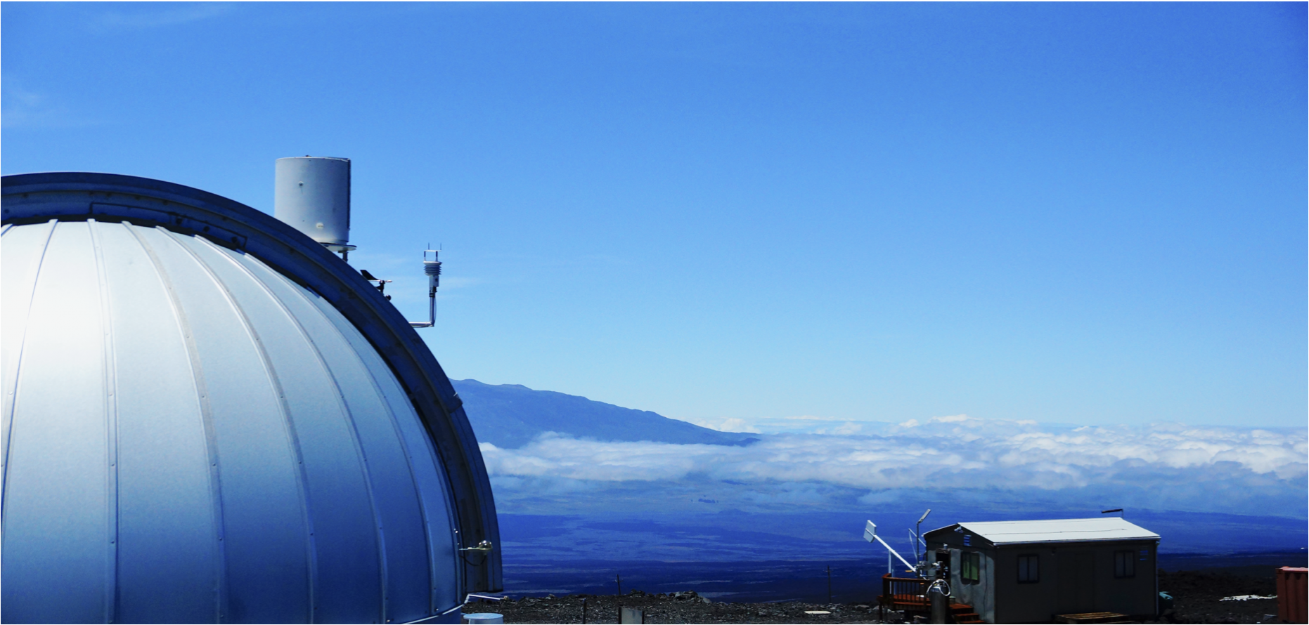
Atmospheric carbon dioxide continued its rapid rise in 2019, with the average for May peaking at 414.7 parts per million (ppm) at NOAA’s Mauna Loa Atmospheric Baseline Observatory.
NOAA’s Mauna Loa Atmospheric Baseline Observatory.
The measurement is the highest seasonal peak recorded in 61 years of observations on top of Hawaii’s largest volcano and the seventh consecutive year of steep global increases in concentrations of carbon dioxide (CO2), according to data published today by NOAA and Scripps Institution of Oceanographyoffsite link. The 2019 peak value was 3.5 ppm higher than the 411.2 ppm peak in May 2018 and marks the second-highest annual jump on record.
Monthly CO2 values at Mauna Loa first breached the 400 ppm threshold in 2014.
“It’s critically important to have these accurate, long-term measurements of CO2 in order to understand how quickly fossil fuel pollution is changing our climate,” said Pieter Tans, senior scientist with NOAA’s Global Monitoring Division. “These are measurements of the real atmosphere. They do not depend on any models, but they help us verify climate model projections, which if anything, have underestimated the rapid pace of climate change being observed.”
The concentration of CO2 in the atmosphere increases every year, and the rate of increase is accelerating. The early years at Mauna Loa saw annual increases averaging about 0.7 ppm per year, increasing to about 1.6 ppm per year in the 1980s and 1.5 ppm per year in the 1990s. The growth rate rose to 2.2 ppm per year during the last decade. There is abundant and conclusive evidence that the acceleration is caused by increased emissions, Tans said.
The Mauna Loa data, together with measurements from sampling stations around the world, are collected by NOAA’s Global Greenhouse Gas Reference Network and produce a foundational research dataset for international climate science.
CO2 and the Keeling Curve
The highest monthly mean CO2 value of the year occurs in May, just before plants start to remove large amounts of the greenhouse gas from the atmosphere during the northern hemisphere growing season. In the northern fall, winter and early spring, plants and soils give off CO2, which cause levels to rise through May.
Charles Keeling was the first to observe this seasonal rise and subsequent fall in CO2 levels embedded within annual increases, a cycle now known as the Keeling Curve.
Click on a thumbnail graphic to view a gallery of drought data from the US Drought Monitor.
US Drought Monitor June 4, 2019.
West Drought Monitor June 4, 2019.
Colorado Drought Monitor June 4, 2019.
Click here to go to the US Drought Monitor website. Here’s an excerpt:
This Week’s Drought Summary
This U.S. Drought Monitor week saw further deterioration in drought-related conditions across portions of the Southeast and lower Mid-Atlantic where persistent hot and dry weather stressed dryland crops, depleted soil moisture, and reduced streamflow activity. Some relief may be on the way during the next week, however, as heavy rains are expected to impact the region. In the South, beneficial rains helped alleviate small areas of drought in the Trans Pecos region of Texas while areas of Abnormally Dry (D0) were introduced on the map across Tennessee in response to short-term dryness and hot temperatures. In the Midwest, severe weather outbreaks and areas experiencing flooding continued to impact parts of the region. According to NOAA’s National Center for Environmental Information (NCEI), several states in the Midwest including Iowa and Minnesota experienced their wettest 12-month period (May 2018–April 2019) on record. In the High Plains, dry conditions during the past month led to introduction of areas of moderate drought in north-central North Dakota. Out West, drought conditions intensified in western Washington where streamflow conditions are well below normal levels after a shallow snowpack this past winter…
High Plains
On this week’s map, an area of Moderate Drought (D1) was introduced in north-central North Dakota in response to short-term precipitation deficits (30-90 days), dry topsoils, reports of stress to pastures, and low stock pond levels. According to the USDA, South Dakota topsoil was 52% in surplus with many areas experiencing flooded fields. For the week, northern portions of the region, including the Dakotas, experienced above normal temperatures with the largest positive anomalies ranging from 2-to-8 degrees above normal while southern portions of the region were a few degrees below normal. Overall, most of the region was dry during the past week with the exception of some isolated showers in Nebraska and eastern Wyoming…
West
On this week’s map, continued warm and dry conditions in the Pacific Northwest led to the introduction of Severe Drought (D2) in areas of western Washington including the Olympic Mountains where Water-Year-to-Date (since October 1st) precipitation at several NRCS SNOTEL stations has been well below normal ranging from the 14th to the 30th percentile. According to the USGS, the 7-day streamflow levels in rivers and creeks across western Washington and northwestern Oregon are flowing well below normal levels. In the Willamette Valley and coastal mountains of Oregon, areas of Abnormally Dry (D0) were added in response to the low streamflow levels and below normal precipitation during the past 30 days. In southwestern Montana, short-term dryness (past 30 days) led to the introduction of an area of Abnormally Dry (D0). In southeastern California and southwestern Arizona, areas of Abnormally Dry (D0) were removed as conditions have improved during the past year with precipitation in western Imperial County, California falling in the top 10% of percentile rankings. During the past week, average temperatures were well above normal across the Pacific Northwest, northern California, and the northern Rockies while the southern half of the region experienced below normal temperatures. Some isolated showers and thunderstorms were observed across the central Sierra, Great Basin, and eastern portions of Colorado and New Mexico…
South
Minor improvements were made on the map in small areas of Moderate Drought (D1) and Abnormally Dry (D0) in the Trans Pecos region of Texas where 1-to-4 inches of rain fell this week. In south Texas, short-term precipitation deficits during the past 30-day period led to the expansion of areas of Abnormally Dry (D0). In northeastern Mississippi and Tennessee, short-term precipitation deficits during the past 30 days and below-normal streamflow levels led to the expansion of areas of Abnormally Dry (D0). Conversely, Oklahoma has experienced a very wet period during the past 30 days with northern portions of the state recording rainfall accumulations of 6-to-12 inches above normal levels. According to the June 3rd USDA Oklahoma Crop Weather report, pasture and range conditions were rated 88% good to fair and livestock condition was rated 92% good to fair. For the week, average temperatures were above normal across most of the region with the largest positive temperature anomalies observed in northern Mississippi and Tennessee where temperatures were 4-to-8 degrees above normal with maximum temperatures reaching the low to mid 90s. Conversely, average temperature were 2-to-6 degrees below normal across the western half of Texas. Some light-to-moderate rainfall accumulations (2-to-4 inches) were observed this week in northern Texas, southwestern Louisiana, and northern Arkansas…
Looking Ahead
The NWS WPC 7-Day Quantitative Precipitation Forecast (QPF) calls for moderate-to-heavy accumulations ranging from 2-to-7 inches across much of the South and Southeast. Further north, lesser accumulations (<2 inches) are forecasted for eastern Colorado and New Mexico, the southern Plains, Midwest, Northeast, and Mid-Atlantic. Out West, dry conditions are expected to prevail across the Great Basin and Desert Southwest while some lesser accumulations (<1 inch) are forecasted for the northern Rockies of Idaho and Montana as well as western Washington. The CPC 6–10-day outlook calls for a high probability of above-normal temperatures across the West with the exception of Colorado, New Mexico, and Wyoming where temperatures are expected to be below normal. Likewise, the eastern two-thirds of the continental U.S. is forecasted to be below normal with the exception of the Gulf Coast region and Florida. In terms of precipitation, there is a high probability of above-normal amounts in areas east of the Mississippi River as well as in Texas and eastern portions of the Desert Southwest while dry conditions are expected in the Pacific Northwest and northern Plains. In Alaska, above-normal temperatures are expected with above-normal precipitation in the southeast, southwest, and coastal areas of south-central.
Click on a thumbnail graphic below to view a gallery of early June drought monitor maps.
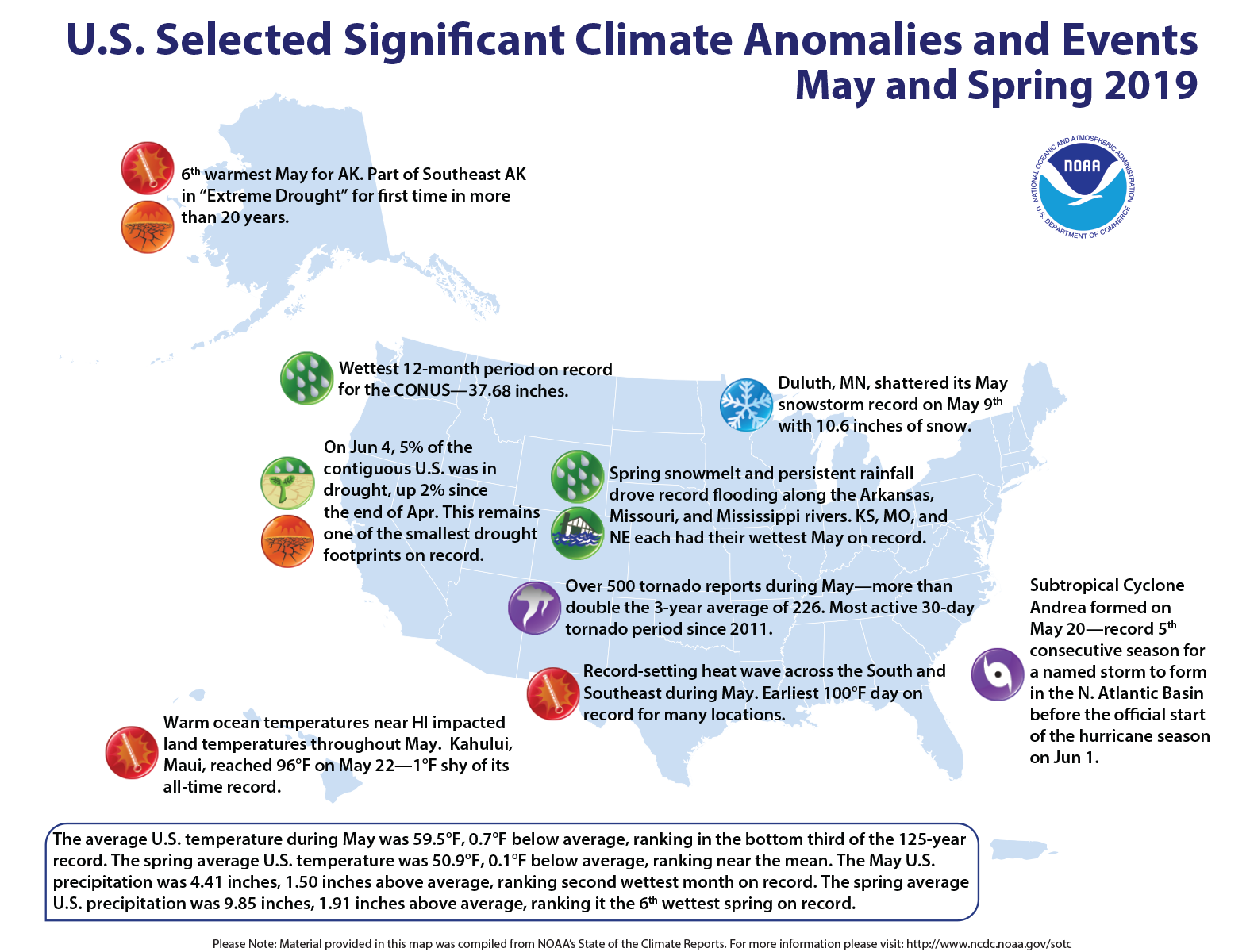
Drenching rains and historic flooding last month ended with May 2019 as the second-wettest month in the U.S. that contributed to a record-wet, 12-month period.
Exceptionally stormy conditions brought more than 500 tornado reports in May — more than double the three-year average of 226.
Here are more highlights from NOAA’s latest climate report:
Climate by the numbers
May 2019
The average May temperature across the contiguous U.S. was 59.5 degrees F (0.70 degrees below the 20th-century average), which ranked in the bottom third of the 125-year record.
The average precipitation for May was 4.41 inches, 1.50 inches above average and ranked second wettest in the 125-year record. The wettest month on record remains May 2015, with 4.44 inches, according to scientists at NOAA’s National Centers for Environmental Information.
Soggy conditions from June 2018 through May 2019 led to the wettest 12-month period on record in the U.S., with 37.68 inches, 7.73 inch above average.
Year to date and Meteorological Spring
The average U.S. temperature for the year to date (January through May) was 43.4 degrees F (0.10 of a degree above the 20th-century average), which falls in the middle third of the year-to-date record.
The average temperature for the contiguous U.S. during Meteorological Spring (March through May) was 50.9 degrees F (0.10 of a degree below average), which also ranked in the middle third of the record.
An annotated map of the United States showing notable climate events that occurred across the country during May 2019. For more, see the bulleted list below and the report summary online at http://bit.ly/USClimate201905.
Other notable stats
Tornado troubles: May 2019 was the most active 30-day tornado period in the U.S. since 2011; more than 500 were reported.
Early action in the tropics: Subtropical Cyclone Andrea formed on May 20, making 2019 the fifth-consecutive year where a named storm developed in the North Atlantic Basin before the official start of the hurricane season on June 1.
Snow still fell: Duluth, Minnesota, had 10.6 inches of snow on May 9, breaking the city’s snowstorm record for May. Denver, Colorado, had its snowiest May in 44 years and tallied 3.9 inches.
Arizona Department of Water Resources Director Tom Buschatzke will participate Thursday in a panel discussion on “Charting a Better Course for the Colorado River” at the annual Getches-Wilkinson Center Summer Conference in Boulder, Colo. Buschatzke’s panel discussion will delve into expectations for the new management guidelines on the Colorado River system, including the new Drought […]
FromThe Grand Junction Daily Sentinel (Dennis Webb):
Aldis Strautins, hydrologist for the National Weather Service in Grand Junction, said so far snow has been melting off in a manageable fashion, with some minor flooding in lowland locations but nothing serious so far.
“We’re not totally out of the woods yet. It bears monitoring and keeping aware of the situation,” he said.
He said the Colorado River is coming up and may peak locally around Sunday. Andy Martsolf, emergency services director for the Mesa County Sheriff’s Office, said flows on the Colorado River at the state line are expected to peak at about 36,000 cubic feet per second this weekend. That’s up considerably from the 24,900 cfs being reported there by the U.S. Geological Survey Wednesday.
Officials expect a possible second peak later this month.
The Gunnison River already is cranking, but that’s by design, under the operational protocol for the Aspinall Unit dams on the river. Erik Knight, a hydrologist with the Bureau of Reclamation, said releases began on Saturday in an attempt to hit a target goal of flows of 14,350 cfs for 10 days on the lower Gunnison at Whitewater, to help critical habitat for endangered fish in that stretch.
He said it appears flows will fall 1,000 cfs short of that goal.
The National Weather Service has issued a flood advisory in the lower Gunnison River due to the extra water releases affecting river levels there. Strautins said it wasn’t a flood warning, but an effort to make people aware of dangers such as banks giving way due to the high water.
Knight said it doesn’t appear that flows through Delta will exceed 13,000 cfs during the 10-day release. That’s below the level at which the Bureau of Reclamation would cut back releases during the 10-day period to protect the community from flooding.
Wilma Erven, Delta’s parks, recreation and golf director, said some water is showing up in a park at the confluence of the Gunnison and Uncompahgre rivers, something that can occur in years like this one…
Strautins pointed to a mix of warmer and cooler weather in the forecast in coming days as opposed to a prolonged hot stretch that could drive water levels particularly high, with cloud cover also expected to moderate melting of snow.
Knight, who several months ago could hardly have imagined Blue Mesa Reservoir filling this year after last year’s low snowpack and drought, said it now appears almost certain to fill…
…the snowpack levels remaining in areas such as southwest Colorado are impressive, as evidenced by the mere fact that many sites that normally are dry by now still have snow.
According to one of the data sets [Brian] Domonkos uses, current snowpack levels in those combined basins and in the Gunnison basin are the second-highest on record, he said. But peak levels this year in basins in western Colorado don’t compare nearly as well to other high snowpack years, with the southwest Colorado basins ranking perhaps fourth or fifth, and other basins not coming in that high, Domonkos said.
He said one of his statistical tools indicates there are about 12.3 inches of snow water equivalent left in the Gunnison basin, which peaked at 24 inches.
“So we’re halfway through the melt of that peak snowpack,” he said.
The Colorado basin has about 11 inches of snow water equivalent left, after peaking at about 20 inches, Domonkos said.
He said snowpack normally melts at a rate of an inch a day or a little less of snow water equivalent.
“So snowpack on average probably won’t be hanging around too much longer,” he said.
While more than half of the Colorado basin’s snowpack already is melted, that snowpack was above-average, and Martsolf said the remaining snowpack is still about 71 percent of an average peak snowpack for the basin.
“We’re definitely melted off from where we would be for a seasonal peak but we still have a ways to go,” he said…
Nowhere in western Colorado is the combined threat of rising rivers and avalanche debris causing more concern than in Hinsdale County. Federal, state and county funding is paying the nearly $1 million cost for the ongoing, emergency removal of the historic, defunct Hidden Treasure Dam. While it no longer holds water, there’s concern that avalanche debris washing down Henson Creek combined with high water flows could destroy it, releasing water and debris and causing downstream flooding…
Both Henson and the Lake Fork of the Gunnison creeks pose threats to Lake City. Lyon said there’s currently no flooding occurring, but creek levels have come up considerably in recent days. Warming temperatures and possible rainstorms both could influence what ultimately occurs in coming days and weeks.
Last month was the snowiest May in Aspen since 1999, with 20 more inches added to the already substantial snowpack. Meanwhile, forecasters are predicting a wet June.
Total snowfall for May was four times the average, according to city of Aspen water department figures. It follows the second snowiest March ever recorded — and the records go back to the winter of 1934-35. Only 6 inches fell in April, but with May’s snowfall, the water department has recorded 210 inches thus far, well above the winter average of 155 inches.
The water department also tallied 3.8 inches of rain for the month, which is double the average. One factor behind the heavy winter and wet spring can be found in the Pacific Ocean, said Erin Walter, a meteorologist with the National Weather Service in Grand Junction.
Winter and spring storms were fueled by weak El Niño conditions that shifted atmospheric rivers laden with moisture farther south than in an average year. (El Niño occurs when, among other conditions, sea-surface temperatures are warmer than average.)
Unceasing storm systems that usually blanket the Northwest, Alaska and Canada instead inundated California’s Sierra Nevada mountain range…
he weak El Niño “definitely influenced the track of storms and the general circulation of our low and high pressure systems,” Walter said. “It’s been a very abnormal winter and spring for us.”
And that may not change anytime soon. Walter said the federal Climate Prediction Center’s one-month outlook for western Colorado, as of May 31, “falls within a 40 percent probability of being above average for precipitation.” The center also is predicting average temperatures for the region.
While the wet, cool spring has meant little snowmelt and allowed for continued skiing, the Colorado Water Conservation Board and local emergency managers are keeping a close watch on river levels…
CWCB also cited a forecast for June that indicates a “wet month for the entire state,” and adds that areas downstream of recent burn scars, like those on Basalt Mountain and surrounding environs from the Lake Christine Fire, are at heightened susceptibility to flash floods, and mud and debris flows. The board reminded “individuals and business owners [to] consider, be aware of, prepare for, and insure against flood threats.”
“It is also important to note that Colorado’s worst flood events have historically occurred from general spring rainfall and summer thunderstorms, which are completely unrelated to snowmelt flooding resulting from mountain snowpack,” the summary says. “For this reason, even residents in areas with lower snowpack should exercise caution in evaluating flood risk.”
Floods directly related to the melting snowpack are possible but unlikely, and for boaters, “an extended season of high water is a near certainty this year,” the board reported.
A flood advisory has been issued for the La Plata River near Hesperus as rising temperatures and increasing snowmelt have pushed the river toward flood stage.
The National Weather Service in Grand Junction said flows along the La Plata River will remain near to slightly above the bank throughout the rest of the week, with the possibility for minor lowland flooding.
As of 7 a.m. Tuesday, a river gauge measured the flow of the La Plata River at 5 feet. A flood stage for the waterway is considered 5½ feet…
The Animas River in Durango was flowing at about 1,500 cubic feet per second Saturday. As of Tuesday morning, the river had reached more than 5,000 cfs and is expected to peak around 7,000 cfs later in the week.
Butch Knowlton, director of La Plata County’s Office of Emergency Management, said Monday that the Animas River begins to spill out onto some areas of the Animas Valley around 7,000 cfs.
The Animas River…was at about 1,500 cubic feet per second Saturday. On Tuesday, the river was running at more than 5,000 cfs and is expected to keep rising.
By the end of the week, the Colorado River Basin Forecast Prediction Center is calling for the Animas to hit nearly 7,000 cfs. (The Animas River usually hits a peak flow of about 4,700 cfs in early June at the height of spring runoff.)
[…]
If the Animas does reach 7,000 cfs, it would mark the largest peak since 2005 in the April-to-July snowmelt window, when the river hit 8,070 cfs on May 26. The last big water year was in 2015 when the Animas peaked at 6,210 cfs on June 12.
The Animas River at 7,000 cfs starts to spill out on the low-lying areas and fields in the lower Animas Valley north of Durango, Knowlton said. At 8,000 cfs, areas around Trimble Lane start to flood.
The water flow for the Animas River to be considered in a flood stage is about 10,500 cfs, Knowlton said. While the river may not hit that mark this year, there is a wild-card type scenario that has emergency managers concerned.
The National Weather Service has issued a river flood advisory for the Gunnison River in Mesa County. Water flows are expected to increase throughout the week.
“Some may start to get above bank full by this weekend. But it’s just something we’re monitoring. It’s not a sharp increase where we expect to see flooding in a couple of days. We are starting to see runoff and an increase in higher flows and higher levels,” said Matthew Aleksa, National Weather Service Grand Junction.
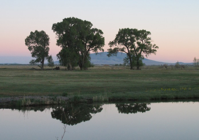
The Yampa River flows through the Carpenter Ranch. Photo courtesy of John Fielder from his new book, “Colorado’s Yampa River: Free Flowing & Wild from the Flat Tops to the Green.”
From Colorado Parks and Wildlife (Jack Taylor) via Steamboat Pilot & Today:
Are you familiar with Colorado Parks and Wildlife’s Habitat Partnership Program (HPP)? If you are in the livestock/agriculture business or a landowner in Routt County you should be.
CPW’s HPP program works to reduce wildlife conflicts, particularly conflicts associated with forage and fences, and to assist CPW in meeting game management objectives. HPP efforts are primarily aimed at agricultural operators and focus on problems and objectives for deer, elk, pronghorn and moose. HPP is funded by receiving 5% of the deer, elk, pronghorn and moose license revenue from each HPP area. This results in millions of dollars annually that can be spent on projects on both private and public land across Colorado.
The local HPP committee in Routt County is the Upper Yampa River HPP committee. The committee is comprised of several local agricultural producers, local sportsman and agency representatives (CPW, Bureau of Land Management, U.S. Forest Serivce). This combination of local knowledge allows for innovative project ideas and novel solutions to problems specific to Routt County.
The Upper Yampa River HPP committee has recently funded several habitat improvement projects, specifically projects that enhanced the amount of water available to both wildlife and livestock on private property. These projects allowed for better grazing practices that will benefit wildlife and livestock into the future.
Other common projects for the Upper Yampa River HPP committee involve assisting landowners with fencing projects. This could be providing materials for a strong welded wire hay stack-yard that can stand up to the snow loads in Routt County or supplying vinyl-coated top wire. The vinyl-coated top wire program helps to reduce the damage that deer and elk can cause to fencing while they are crossing it because the vinyl-coated wire is more visible, which also results in fewer deer and elk fence entanglement issues.
The possibilities do not end there. In addition to fence and forage type projects, the Upper Yampa River HPP committee also assists landowners with funding a portion of the transaction costs for conservation easements.
HPP looks for a 50/50 cost split to approve the project being submitted. This means if you are asking the HPP committee to contribute $2,000 to a habitat improvement project on your property, they would be looking for a contribution from you worth $2,000.
The Upper Yampa River HPP committee also considers any other partners associated with the project, like a neighbor, if the project can span multiple parcels of property.
To submit a project with the Upper Yampa River HPP committee, contact your local district wildlife manager directly or call the CPW Steamboat Springs Service Center at 970-870-2197. Upper Yampa River HPP meetings are typically held once a month. Contact Colorado Parks and Wildlife to learn more.
Jack Taylor is a district wildlife manager for Colorado Parks and Wildlife.
Christmas Elk via the Middle Colorado Watershed Council December 2013
Brad Wind, general manager of the Northern Colorado Water Conservancy District based in Berthoud, and Jim Hall, Northern Water’s senior water resources engineer, briefed the LSPWCD’s board of directors on Northern’s efforts to keep Colorado-Big Thompson water from leaving the Northern District…
Wind told the Lower board that Northern is working to enforce Article 19 of the 1938 contract between Northern Water and the federal government, known as the Project Repayment Contract. That article, one of 27 contained in the contract, specifies that all seepage and return flows from the use of Colorado-Big Thompson project water are reserved to Northern Water and are not to be taken outside the district’s boundaries.
On May 9, Northern adopted a resolution saying it would “take appropriate actions to enforce Article 19 consistent its interpretation of Article 19.”
Wind said the heavy lifting in that effort will be tracking how C-BT water, and resulting seepage and return flow, are used. He used the phrase “colors of water,” which is a concept that holds that, through close monitoring and accounting, mixed waters from various sources actually can be tracked through multiple uses. For instance, water that is native to the South Platte Basin can be accounted differently from C-BT water, which is diverted from the Colorado River into Grand Lake and piped through the Adams Tunnel to Estes Park and held in Horsetooth Reservoir and Carter Lake for distribution to C-BT members.
Return flows are water that has been diverted from the river, used to irrigate crops or for municipal use, and either seeps back to the river through the ground or is discharged after treatment. Much of the river’s flow in the lower reaches in late summer and through the winter is from return flows from upstream use. Return flows are crucial to irrigators in Weld, Morgan, Washington, Logan and Sedgwick counties.
“To protect return flows, we have to know what they are,” Wind said. “We have to be able to quantify what return flows are coming from C-BT use and what’s from native water. It’s complicated.”
Hall told the Lower board that there is the danger that “change of use” cases going through Colorado water courts could result in return flows from C-BT water being shipped out of the Northern district in violation of Article 19.
“We’re starting to see change cases on irrigation ditches moving water outside the district boundaries,” Hall said. “That’s why it’s important to track this stuff. It’s easier to track municipal water because we can look at their (wastewater treatment facility) discharges, but it’s harder to prove agricultural return flows.”
Hall said return flows from native water are not subject to Article 19, only C-BT return flows.
Wind said Northern will be watching closely all change of use cases that go through Colorado’s water courts and will continue monitoring water usage in the district to make sure C-BT water doesn’t leave the district.
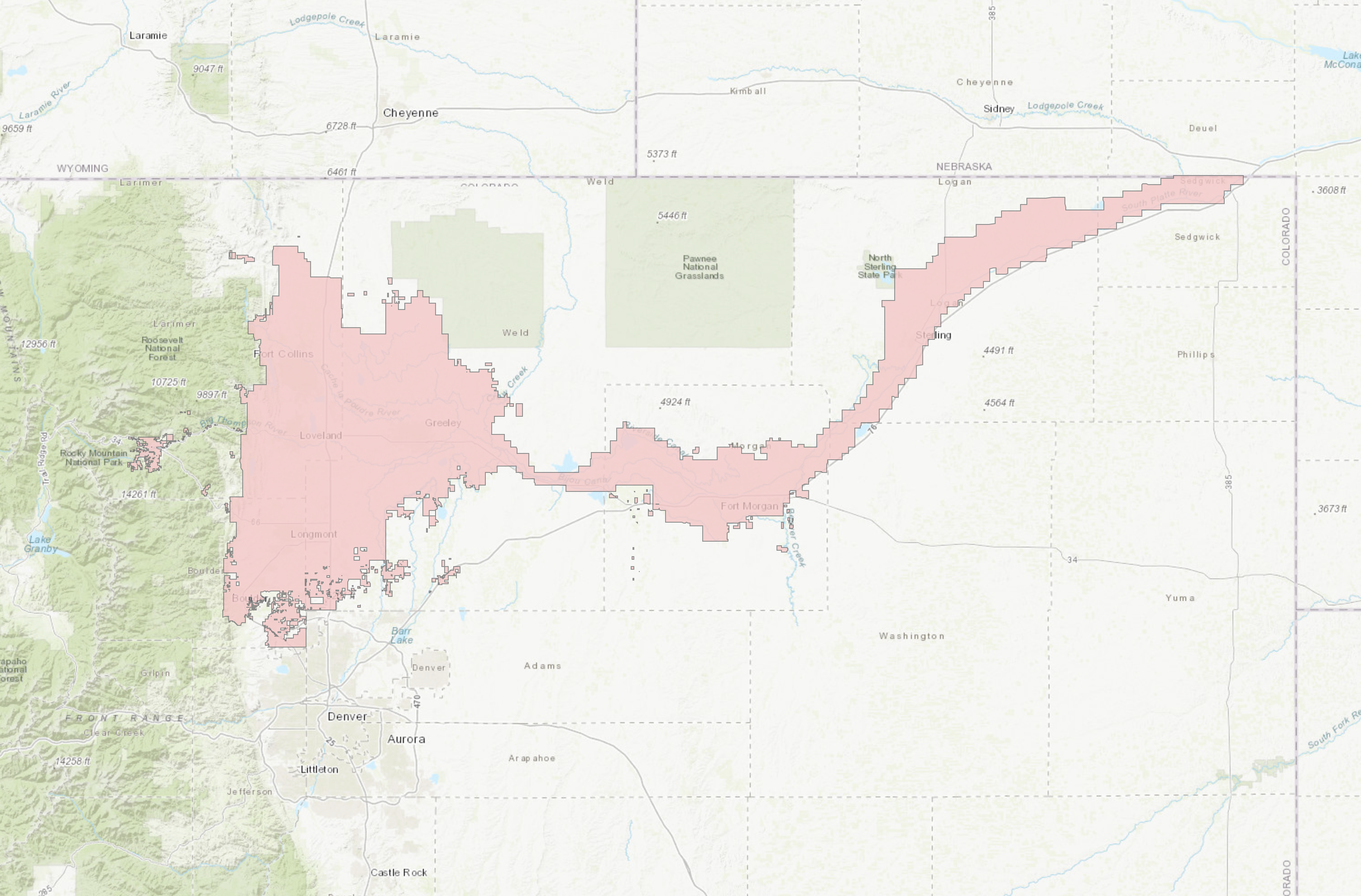
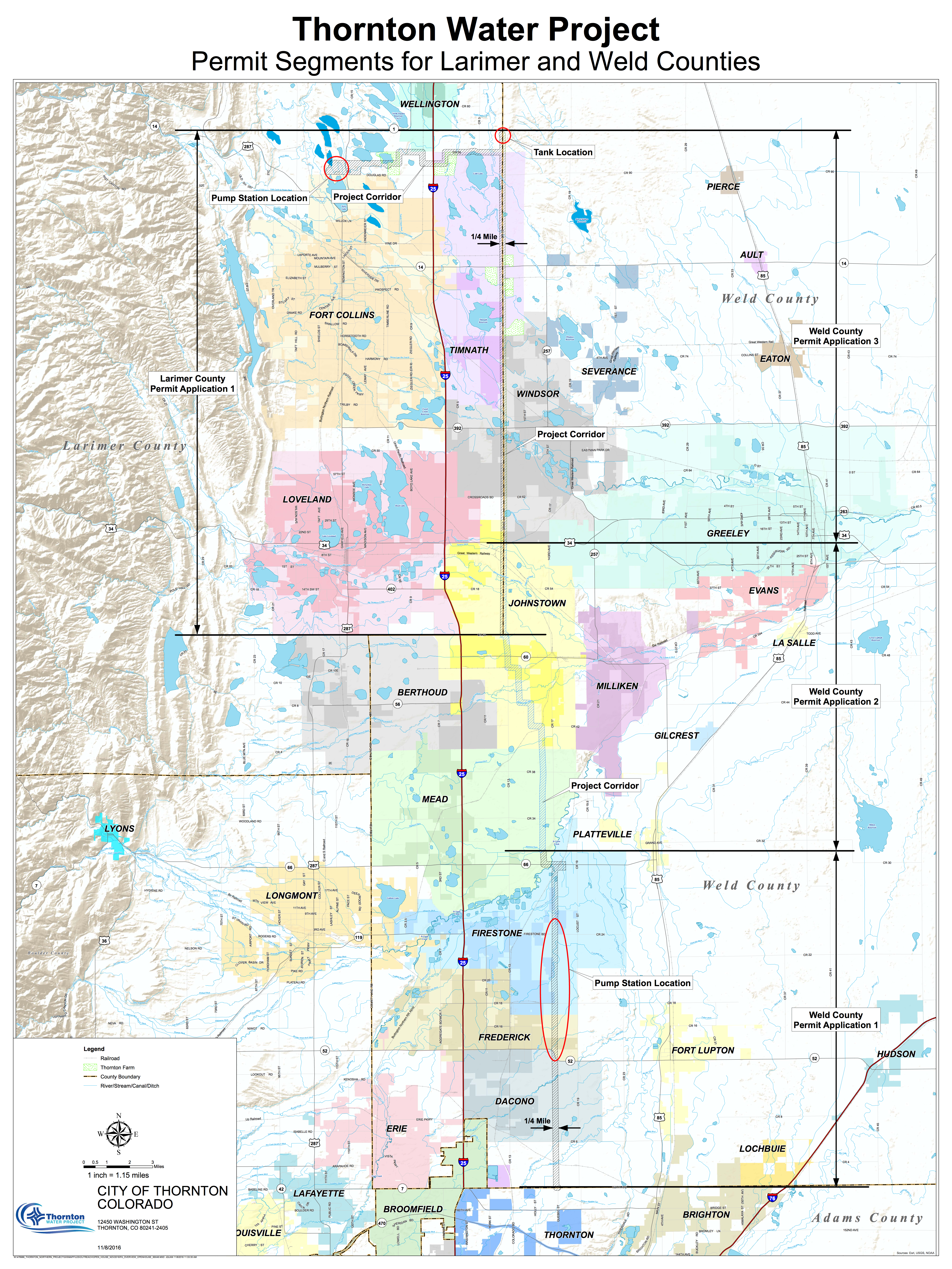
Larimer County leaders are asking a court to uphold their rejection of the Thornton pipeline.
The city of Thornton sued Larimer county commissioners in April, asking the Larimer County District Court to overturn the board’s decision and either approve one of the two proposed pipeline routes or force the county to do so. Larimer County commissioners filed their response to Thornton’s lawsuit Monday afternoon.
The legal battle is the latest twist in a yearslong fight over a proposed pipeline that would carry Poudre River water from reservoirs north of Fort Collins to Thornton…
Pipeline opponent No Pipe Dream and river advocacy group Save the Poudre both plan to intervene in the lawsuit, those groups’ leaders told the Coloradoan. If the court allows the groups to intervene, they’ll become parties in the lawsuit…
Commissioners argue the court must affirm their decision if there’s any “competent evidence” in the record supporting it. Competent evidence is a legal term describing evidence that tends to prove a matter in a dispute.
The county also argues the court doesn’t have the authority to substitute its own judgment on the pipeline path. If the court decides commissioners made the wrong call, it must send the case back to the board for reconsideration and correction, the answer argues.
Next steps in the lawsuit could include a motion for judgment or a scheduling conference for the parties to discuss the potential of a settlement or plan a discovery period and timeline for a trial.
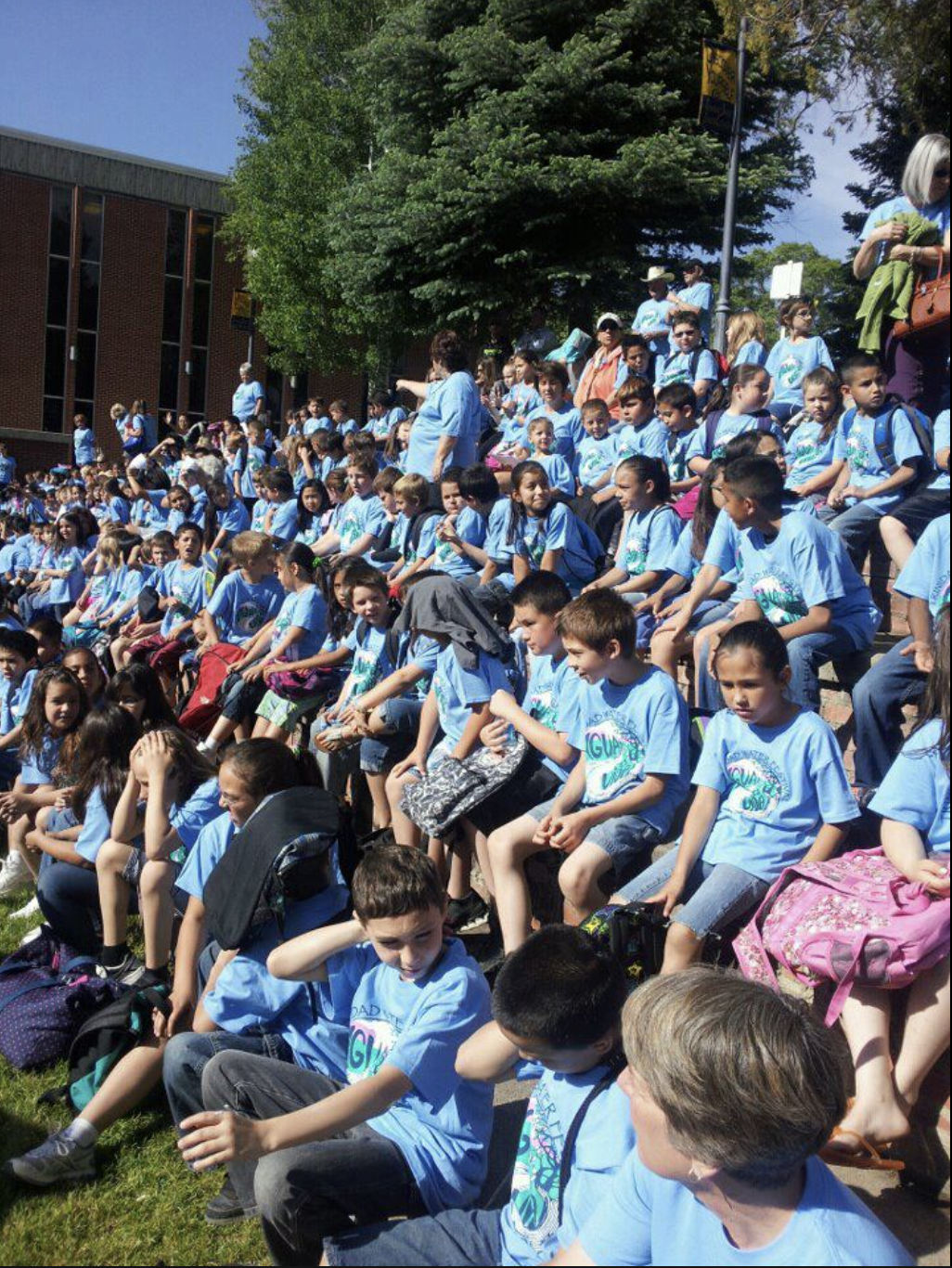
Photo credit: Trinidad Water Festival Facebook page.
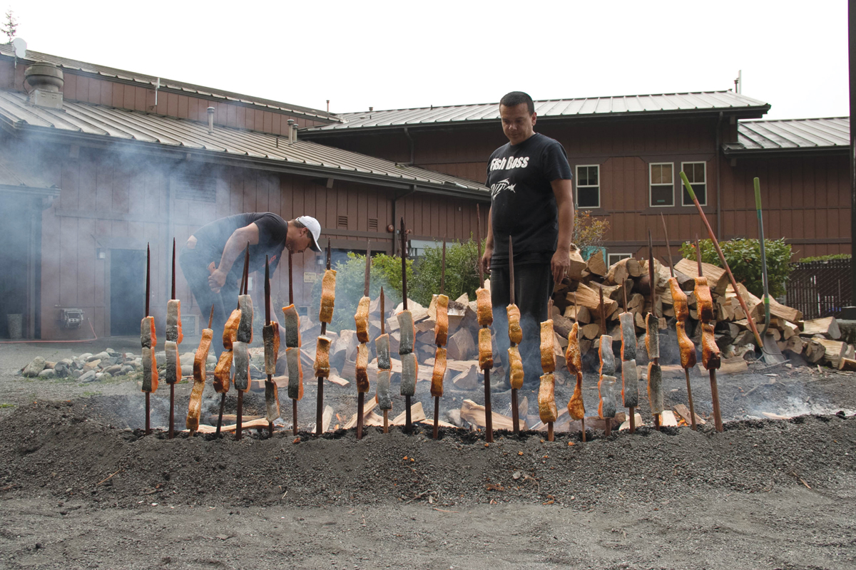
From the Colorado Springs Military Newsgroup (Michelle Blake):
For the seventh year, Fort Carson staff supported the annual Trinidad, Colorado, Water Festival May 16, 2019, an event where students from kindergarten through 12th grade learn from local professionals about water conservation and the importance of water.
Event organizers said they believe investing in youth, education and the environment is a strong strategy for protecting and improving the natural environment. This year, more than 1,250 students from 14 different Las Animas County schools came to the Trinidad State Junior College campus to visit 40-50 presentations celebrating the theme “Aqua la Vida.”
Fort Carson staff provided four presentations. Jack Haflett, Directorate of Public Works (DPW) Environmental Division environmental protection specialist, used a colorful “Terminology Potpourri” poster to introduce the students to key concepts in pollution, mitigation and compliance and then encouraged them to practice soaking up mini oil spills with absorbent pads and beads.
A glass cylinder filled with cooking oil, a sports drink, isopropanol alcohol and syrup were used to demonstrate how different materials do not mix, and also how the properties of different substances determine which cleanup technique is implemented.
Students participated in the “Survey Says!” game with Craig Dengel, DPW Environmental Division Piñon Canyon Maneuver Site (PCMS) archaeologist, with the goal of identifying the seven key things that people require to survive (air, water, food, shelter, sleep, technology and family). The game was used to illustrate the historical settlement patterns of humans, which often coincide with proximity to reliable sources of water, such as oceans, rivers and lakes, and how water provides food and transportation opportunities.
DPW Environmental Division PCMS wildlife biologists highlighted some of the unique physical and behavioral adaptations that animals have developed in order to survive in a climate where water is a limiting resource. Students were able to examine a live bull snake to understand how the snake’s scales reduce water loss, reflect light and provide camouflage.
The biologists discussed the different ways that PCMS simultaneously supports the military mission and the environment through their Water for Wildlife Program, which uses solar powered wells and guzzlers. The presence of these reliable sources of water reduces the stress on individual animals, and helps offset the pressures from various training activities.
Finally, the students gathered around Directorate of Emergency Services PCMS Firefighter Kevin Filkins, Station 35, to learn how the Fire Department responds to wildland fires and implements prescribed burns to support a healthy, natural ecosystem. Filkins described the equipment that firefighters use on wildland fires, including water, personal protective gear and various hand tools.
From email from the Colorado Department of Water Resources:
[Please find below] two documents relating to the investigation of demand management feasibility – both at the Upper Basin level and within Colorado. First, a statement from Director Mitchell on the path forward on demand management feasibility investigations within Colorado. Also, information regarding an upcoming workshop hosted by the Upper Colorado River Commission on the topic of demand management feasibility.
For more information on these topics email demandmanagement@state.co.us.
Demand Management Investigation: The Path Forward
Colorado water users, stakeholders, and interested parties:
Now that the Colorado River Basin Drought Contingency Plan (DCP) is finalized, the Colorado Water Conservation Board (CWCB) is beginning its efforts to investigate the feasibility of a potential demand management program within Colorado.
The strong connection between Coloradans and our water has established a foundation of public input, deliberation, and participation in the decision-making process, which leads to informed and thorough policymaking. This is the model that informed the Colorado Water Plan, and it is this model that the CWCB will utilize to assess demand management: by Colorado, for Colorado.
At the March 2019 meeting, the Board of Directors of the CWCB approved the 2019 Work Plan for Intrastate Demand Management Feasibility Investigations. Below are highlights of the current and upcoming steps that the CWCB staff will be taking to implement the 2019 Work Plan, including opportunities for engagement, processes to inform the Board, and informational events. These elements are designed to ensure that the CWCB and all interested water users and stakeholders are fully informed of demand management concepts and challenges as they are identified. Through this process, the multitude of considerations demand management presents will be fully understood, to promote an informed and fully realized public policy discourse.
General Outreach: Staff will continue to work directly with interested water users and stakeholders to inform them of the process for investigating demand management feasibility within Colorado, and to solicit input on specific elements of potential implementation and solution identification. The direct interaction between staff and the various basin roundtables, policy boards, water users, and stakeholder groups is where the conversations begin. This will then lead to identification of considerations and development of potential solutions, which will be used to inform an evaluation of demand management.
Workgroups: Staff has begun to reach out to subject matter experts on various elements that must be considered for any potential demand management program within Colorado. The purpose of these workgroups is to help CWCB staff identify and frame the complex issues associated with demand management feasibility for public and Board consideration. In this capacity, workgroup members operate like “think tanks” to help CWCB staff prepare to conduct meaningful public discussion of the issues associated with demand management based on useful insight and understanding from experts in the field. Workgroup members have been selected for their subject matter expertise and willingness to work in assisting the State as it implements the public process to evaluate a potential demand management program.
To respect the integrity of the workgroups, members are being asked to participate in a non-disclosure setting. This will allow the participants to brainstorm all sides of an issue, and to have open and frank discussions as they assist CWCB staff in framing demand management considerations for public discussion and evaluation. The decision-making process for consideration of demand management solutions and approaches for potential implementation will be achieved in public meetings and through the comment and input process established in the formulation of the Colorado Water Plan. The workgroups serve as the “think tank” for staff as they begin to develop an understanding of the full complement of considerations, issues, and challenges that demand management presents.
Transparency of Process – Demand management investigations and decision-making by the CWCB will be done through an open dialogue. Once the range and multitude of complex topics associated with demand management are identified and framed, they will be introduced in a process akin to the development of the Water Plan, including workshops, basin roundtable presentations, consideration of public comment, and the like. Additionally, the CWCB will be updated regularly in open session on the progress of the demand management investigation process, and provided with any staff recommendations as appropriate.
Upcoming Demand Management Investigation Events –
CWCB will be hosting an Orientation Webinar for members of the workgroups in July. This Orientation Webinar will be open to the public. The Webinar will provide an overview of the evolution of DCP and demand management, discuss the statewide perspective for analysis of demand management, and outline the timeline and process for the workgroups’ assistance in demand management issue identification. Information about the Webinar will be forthcoming as details are finalized.
The Upper Colorado River Commission will be hosting a Demand Management Stakeholder Workshop in Salt Lake City, Utah on Friday, June 21. The goal of this regional workshop is to provide a baseline understanding of the Colorado River DCP and discuss proposed next steps to examine the feasibility demand management in the Upper Basin. Additionally, Upper Basin State representatives will receive comment and input from interested water users and stakeholders on possible considerations in evaluating the feasibility of a successful demand management program throughout the Upper Basin. When the agenda is finalized, more information regarding the Workshop and registration will be posted on the CWCB website and circulated to interested parties.
CWCB staff will be scheduling public demand management workshops around the state, as outlined in the 2019 Work Plan. These workshops will be in addition to the usual array of roundtables, Interbasin Compact Committee, informational forums, and other water meetings in which staff participate to discuss and receive feedback on demand management. Staff hopes to schedule the first intrastate workshop in alignment with the summer conference of Colorado Water Congress.
The investigation of the feasibility of a potential Demand management program presents a challenge for the CWCB, water users, and stakeholders across Colorado. The Board and staff take this assessment very seriously, and are committed to providing an opportunity for everyone with an interest in Colorado River system sustainability to make their voices heard, while remaining true to the water values identified in the Colorado Water Plan. For more information, to provide comments, or to learn more about the 2019 Work Plan and demand management feasibility process, email demandmanagement@state.co.us or contact CWCB staff.
We’ve made a big deal about these statistics, and snowpack is unquestionably far higher than where it normally is for the beginning of June. But, these numbers – while true, of course – might be a bit misleading and worth an extra note of clarification. On Friday, the Colorado Climate Center sent a series of tweets to help explain the significance behind some of the snowpack data figures that have garnered so much attention.
So essentially, it’s the slow start to the melting season – fueled by cold late spring temperatures and, yes, some bouts of late May snow – that’s keeping Colorado’s snowpack so ridiculously high.
More than 12,000 people are expected to attend the international ACE19 meeting, focusing on ‘Innovating the Future of Water.’ The post Denver to host biggest water conference of its kind in June appeared first on News on TAP.
See what Denver Water experts will talk about when ACE19 rolls into town. The post Denver Water employees to share knowledge and expertise with peers appeared first on News on TAP.
Forecasters are anywhere from concerned to alarmed about the potential for flooding in Colorado’s high country…
The snow water equivalent, or SWE, of snowpack in the mountains peaked at 20.5 inches on April 15, but was still at about 16.5 inches on Thursday, according to the National Weather Service in Boulder…
“I wouldn’t say go out and get ready for a massive flood, but getting prepared is a good idea,” NWS meteorologist Natalie Sullivan said Friday. “These levels are definitely something to keep an eye on, but it is not overly alarming.”
The SWE of 16.5 inches is more than three times higher than the normal for May 30, which is more typically 4.5 inches to 6 inches, according to the National Weather Service. The variations in normal levels are attributable to different areas of Colorado.
At an Arvada fire station, Polis signed into law House Bill 1279, which bans certain kinds of foam used in firefighting training. Such foam contains so-called “forever chemicals” that have contaminated drinking water in El Paso County and elsewhere…
The foam contaminated Fountain’s water supply, and it has since installed filters to deal with problem…
HB 1279 bans Class B firefighting foams that contain “intentionally added” per- and polyfluoroalkyl substances, also known as PFAS. Such chemicals were used for decades at Peterson Air Force Base in Colorado Springs and have been found in the nearby Widefield aquifer, which serves Security, Widefield and Fountain.
The foam was sprayed on the ground and used in a firefighting training area that was flushed into the Colorado Springs Utilities treatment system, which was ill-equipped to remove the chemicals. The effluent ended up in Fountain Creek, which feeds the Widefield aquifer.
The Air Force since has replaced that foam with a new version that the military says is less toxic, though it still contains perfluorinated chemicals.
Pond on the Garcia Ranch via Rio Grande Headwaters Land Trust
In Salida, Polis signed House Bill 1264, which is intended to resolve some of the long-standing problems with the state’s conservation easement program.
Landowners say the Colorado Department of Revenue revoked tax credits awarded to those who entered into conservation easements with land trusts, with more than 800 credits revoked from the 4,000 granted in the program’s first 15 years.
HB 1264 is intended to make the program more transparent, with a warning to landowners that easements are in perpetuity. The bill also requires the Division of Conservation Easements, within the Department of Regulatory Agencies, to set up a committee to determine how to repay those tax credits.
The committee is to hold its first hearing June 25, an addition to the bill made by Sen. Jerry Sonnenberg, R-Sterling.
Legislative leaders in both parties are to appoint the committee members, and lawmakers say they intend to include representatives for those who have been denied tax credits as well as other program critics.
Colorado Governor Jared Polis chose the banks of the Arkansas River in Salida as the ideal location to sign an unprecedented nine bills into law on Monday morning, June 3. The location underscored both the importance of these bills to Colorado’s rural and recreation economies, as well as highlighting Colorado’s growing preference for collaboration to get things done…
SB19-221 – CO Water Conservation Board Construction Fund Project
This bill sponsored by Donovan and Roberts, is focused on the funding of Colorado water conservation board projects, and assigns an appropriation to protect those projects…
SB19-186 – Expand Agricultural Chemical Management Program Protect Surface Water
Another bill sponsored by Donovan, Catlin, Coram and including Rep. Jeni Arndt, seeks to protect Colorado surface water from contamination by the expansion of agriculture chemical management plans.
The exterior of the James W. Broderick Hydroelectric Power Facility at Pueblo Dam, which began producing electricity this week. Photo credit: Southeastern Colorado Water Conservancy District
Workers prepare a turbine and generator at the James W. Broderick Hydroelectric Power Facility at Pueblo Dam shortly before it began producing electricity this week. Photo credit: The Southeastern Colorado Water Conservancy District
Here’s the release from the Southeastern Colorado Water Conservancy District (Chris Woodka):
The $20 million James W. Broderick Hydroelectric Power Facility at Pueblo Reservoir began operations this week after testing and commissioning were completed during May.
The plant will produce electricity by harnessing flows that pass through the north outlet of the dam into the Arkansas River. Water rushing through the turbines is not consumed during the process, but simply returns to the river.
The Southeastern Colorado Water Conservancy District signed a Lease of Power Privilege with the U.S. Bureau of Reclamation in August of 2017, and began construction shortly afterward. Reclamation approved full operations this week.
Mountain States Hydro LLC, of Sunnyside, Wash., was the general contractor for the design-build project, which was financed through a $17.2 million low-interest loan from the Colorado Water Conservation Board, and the District’s Enterprise.
“This is an important step for the District,” said Southeastern’s Executive Director Jim Broderick. “We envision this as a long-term revenue source for Enterprise programs, such as the Arkansas Valley Conduit. Equally important will be the new source of clean power we have created.”
The Southeastern Board voted in April to name the hydro plant for Broderick. A dedication is being planned, but no date has been set.
The 7.5-megawatt plant will generate 28 million kilowatt-hours of electricity annually, roughly enough to power 2,500 homes. Three turbines and two generators within the plant can be used individually or in tandem to take advantage of releases from Pueblo Dam ranging from 35-810 cubic feet per second.
The Pueblo Dam Hydro plant was constructed on a dedicated connection to the North Outlet Works, which was constructed by Colorado Springs Utilities as part of the Southern Delivery System.
The genesis of the project came in 2011, when Reclamation published a notice of intent to develop environmentally sustainable hydropower at Pueblo Dam. Southeastern, Pueblo Water and Colorado Springs Utilities partnered in the application for the Lease of Power Privilege.
Southeastern remained as the sole signer of the lease in 2017, after working on a preliminary design with Mountain States. Colorado Springs Utilities, which operates four hydro power plants, is working with Southeastern to provide technical assistance and power scheduling both during startup and operations.
Power from Pueblo Dam Hydro will be sold to the city of Fountain, and to Fort Carson, through a separate agreement with Colorado Springs Utilities for the first 10 years of generation. For the next 20 years, Fountain will purchase all of the power generated by the plant.
“Through this unique partnership, we are proud to assist Fort Carson with its renewable energy initiatives, collaborate with the City of Fountain and strengthen our ties to the Southeastern Colorado Water Conservancy District,” said Colorado Springs Utilities General Manager John Romero. “This project further leverages the investments that citizens of the region have made in both the Fryingpan-Arkansas Project and the Southern Delivery System.”
“We’re very excited,” said Curtis Mitchell, utilities director for Fountain. “This provides us with a source of clean electric power, and it has the added benefit of saving money for our ratepayers.”
Professor Frances Ramaley with picnic group. Photo credit: CU Boulder Mountain Research Group
Here’s a report from The Boulder Daily Camera (Charlie Brennan) via The Loveland Reporter-Herald. Click through and read the whole thing. Here’s and excerpt:
The University of Colorado Boulder’s Mountain Research Station, within the Arapaho-Roosevelt National Forest and situated just a few miles west off of Colo. 72, is the jumping-off point for some of the most important ongoing research into the nuanced and changing dynamics of alpine ecology going on anywhere in North America.
Increasingly, the focus of that work relates directly to the signals and effects of climate change — a problem not even being considered by scientists when University of Colorado biology professor Francis Ramaley launched the Tolland Summer Biology Camp in the vicinity in 1909.
That camp, where primary tools included shotguns, shovels and butterfly nets, closed in 1919, and after the university bought the land to the north, it built what was known as the University Camp.
It was a successor to Ramaley, biology professor John W. Marr, who in 1946 would initiate the Mountain Ecology Project, the Mountain Climate Program, and the East Slope Ecology Project, and who was key to establishing the Institute of Arctic and Alpine Ecology, which would merge in 1952 with the University Camp as the Institute of Arctic and Alpine Research.
The frontier of research into the effects of a changing climate, where animals and plants are living at the extreme limits of environmental tolerance at up to 12,000 feet, has continued to be expanded there — with ground-penetrating radar and drones now displacing shotguns and shovels — for well over half a century.
“The idea that humans could have such a pervasive impact on not just regional environment but the global environment, I don’t think was really understandable back then,” Bill Bowman, research station director for the past 29 years, said of its earliest days.
Now, said Bowman, a professor in the CU Boulder Department of Ecology and Evolutionary Biology, “It is the very theme of research that goes on there, the impacts of humans on the environment.”
An alphabet soup of laboratories and agencies participate directly in research based out of the research station. They include not just INSTAAR, the National Ecological Observatory Network, the National Oceanic and Atmospheric Administration and the Critical Zone Observatory, but also researchers who don’t have weighty acronyms anchored to their curriculum vitae.
“We’ve got everything from individual grad students doing their masters theses, up to the groups that have been working up there for almost 40 years now,” Bowman said. “And so really, anybody can do research up there. We don’t make a distinction about whether they are rich and famous, or just starting in science. We really take pride in that a lot of researchers get their first experience in doing research up there.”
[…]
The Mountain Research Station base facilities, including the John W. Marr Alpine Laboratory, a family lodge with capacity for up to 32 visitors, and the Kiowa Laboratory and Classroom, with meeting space to accommodate 24, are perched at a mere 9,500 feet.
With individual data collection points spread across a challenging terrain topping out with the highest at 12,267 feet, and snow that can pile up in some spots as deep as 15 to 20 feet, simply navigating this living laboratory can be an imposing challenge.
But many of those who work there consider the opportunity to do so a gift. An example would be Duane Kitzis, a senior research associate for CU Boulder’s Cooperative Institute for Research in Environmental Sciences, who works for the Global Monitoring Division of the Earth System Research Laboratory at NOAA. He has been going up Niwot Ridge since 1987, collecting air samples that are used to provide calibration material for the measurement of greenhouse gases at laboratories around the world. He now makes more than 400 standard air measurements per year up there…
Katharine Suding is the lead investigator for one of the major research programs being conducted in the breathtaking landscape above the research station. Known as the Niwot Ridge Long Term Ecological Research program, it’s an interdisciplinary research initiative aimed at building a predictive understanding of ecological processes in high-elevation mountain ecosystems, and contributing to broad advances in ecology.
“We need long-term studying and monitoring of these complex systems to start being able to understand how they work and predict how they’re going to work in the future,” Suding said of the project, supported by funding from the National Science Foundation.
The Niwot Ridge research program has climate records (both temperature and precipitation) dating to 1952 at four places along an elevation gradient topping out at its “D1” site; that’s the one perched at 12,267 feet.
Suding’s project has the regular involvement of about 15 faculty, eight staff members, 25 graduate students and 10 undergraduates at CU Boulder. A few are stationed full time at the research station, and one or two rarely stray from the work under microscopes examining samples at laboratories down in Boulder. Most split their time between the city and the alpine world.
On a recent trip — by snowcat, across the snow that still blanketed the landscape well into May — through her program’s 4-square-mile research area, Suding, a professor in the Ecology and Evolutionary Biology Department at CU and fellow at INSTAAR, observed the interplay of snowpack, snowmelt, changes in temperature and air quality impact the fragile ecosystem in myriad ways.
“We know that in the forests, with a longer summer, the forests don’t do as well, because they get really stressed out in July and August, when it’s really hot and they don’t have the moisture,” she said. “We thought this tree line would go up, if the summer was longer and hotter. But it is not going up, because the young trees can’t start growing up here because it’s too dry.”
[…]
Suding’s research territory borders on the westernmost reaches of the Boulder Watershed, where CU Boulder scientists also collect data, only working under permission from city officials. At the top of the watershed, at 12,513 feet, sits Arikaree Glacier, which Suding’s predecessor Mark Williams predicted could vanish completely in 20 to 25 years. That sobering forecast hasn’t changed.
Predicting our climate future, according to Suding, depends on understanding how our ecology has evolved, particularly in response to the dramatic changes wreaked by the Industrial Revolution.
The upper Colorado River, looking upstream toward Gore Canyon, near Pumphouse. Photo: Brent Gardner-Smith/Aspen Journalism
From the Colorado River Water Conservation District via the The Sky-Hi Daily News:
Colorado’s eponymous river is doing relatively well in early June 2019 with significant snowpack still lingering at higher elevations, making the river basin’s water managers cautiously optimistic as they look at the state of one of the nation’s key waterways.
Last Thursday evening the Colorado River District, a special taxing district dedicated to the conservation and management of the Colorado River and its stream flows, held a public forum at West Grand High School in Kremmling regarding the current status of the Colorado River. Each year officials from the River District present a series of public forums called “state of the river” meetings in various communities up and down the length of the basin. State of the River meetings are typically held each year in the late spring prior to the start of high runoff periods and irrigation season.
The state of the Colorado River is relatively strong in 2019 following a solid year for snowfall in Colorado’s High Country but despite plentiful precipitation water managers are struggling against a surprising impediment: low temperatures.
“With this cold and wet weather, the snow is lingering much longer than normal,” Victor Lee, a hydrologic engineer with the federal Bureau of Reclamation, said. “It has not run off like it typically does. We are going into June with a very delayed peak runoff.”
Despite the delayed start to high water season in the Rockies water managers are cautiously optimistic about the state of the river this year and the impacts from this year’s snowpack. Multiple officials presenting at the State of the River meeting noted they plan to fill, but not spill, the major reservoirs in Grand County with the exception of Wolford Mountain, which is expected to spill sometime later this summer. Nathan Elder, with Denver Water, said the entity he works for anticipates reduced diversions out of Grand County this year thanks to predicted higher than average native stream flows in East Boulder Creek.
Even with the improved snowpack in 2019 though officials continue to sound alarm bells about the future of the key waterway of the American southwest, noting the river basin currently consumes more water than Mother Nature replaces, even in wet years. Andy Mueller, General Manager for the Colorado River District, gave a presentation on drought contingency planning for the Colorado and made several sobering statements about the future water in the west.
According to Mueller the Colorado River basin uses up roughly 16 to 17.5 million acre-feet of water each year, though on average the basin rarely receives that much precipitation annually. To cover the gaps between how much water is consumed and how much is received water managers rely on the massive network of reservoirs that dot the western US to provide the supply. That supply is dwindling though as the water deficit continues to grow.
Mueller noted that the 10-year running average for the amount of water deposited by the environment into the Colorado River basin continues to decline. The current 10 year running average is now just above 12 million acre-feet a year. Mueller noted the ongoing impacts of climate change and a warming environment on the water picture in the west and presented a slide showing average temperature data for the Colorado River going back to 1900.
According to Mueller the Colorado River is now, on average, a full two degrees warmer than it was 30 years ago. The slide provided by Mueller shows a marked uptick in river temperatures beginning in the early 1980s. Since 1983 the Colorado River has experienced only three years when river temperatures were below historic averages.
“Recent studies indicate there is a three to four percent decline in annual runoff in Colorado for every one degree of warming,” Mueller said, noting that researches believe the decreased runoff is a result of a longer growing season, allowing vegetation to consume more water naturally.
“The forests are using more water, the riparian area is using more water,” Mueller said. “We have a supply problem. The question is, where are we headed?”
Yampa and White Basins High/Low Precipitation Summary May 31, 2019 via the NRCS.
From the Steamboat Pilot & Today (Eleanor C. Hasenback):
According to data from a National Weather Service cooperative weather station, Steamboat Springs receives a long-term average of 2.15 inches of water in May.
Data from that station shows the area received nearly double that average, with a total of 4.26 inches in May. This data is preliminary, and the National Weather Service will release its official tally of May precipitation later this month.
Steamboat received 9.3 inches of snow in May, well over the long term May average of 2.8 inches at the station.
That snow hasn’t melted off the mountains, either. The Natural Resource Conservation Services’ snow telemetry site atop the Continental Divide on Buffalo Pass measured 115 inches of snowpack on the ground on Sunday. There were 35 inches at the Rabbit Ears Pass site…
“This has been a pretty active year — a pretty wet winter and spring. … I think that’ll have some influence on the temperatures too because as the sun is melting the snow, it’s not able to heat the ground as much. That could be a reason why our temperatures could be at or below normal for this short-term forecast,” said Erin Walter, a meteorologist at the Weather Service Forecast Office in Grand Junction…
“The warmer temperatures are just going to increase the runoff, so that’s kind of the big threat right now for Western Colorado,” she said.
The river runners’ adage states that the Yampa River peaks when two brown spots atop Storm Peak meet. Those brown spots have yet to make an appearance this spring.
The Yampa River sees an average peak in early June around 2,250 cubic feet per second at the U.S. Geological Survey’s Fifth Street gauge in downtown Steamboat, though the peak has ranged from 1,570 to 5,200 cfs in the last ten years.
For much of the last month, the river has flowed relatively consistently between 1,000 and 1,500 cfs through Steamboat, though the Weather Service forecast that the Yampa will rise to about 3,600 cfs later this week amid sunny weather starting Tuesday.
Walters said the forecast for June looks to see average temperatures and a slightly above average chance for “wetter than normal conditions.”
While this year is shaping up to be a good water year so far, climatologists and water managers are still concerned by a trend of drought intensified by warmer temperatures and an earlier spring in the West.
“Just because we have one good year … doesn’t negate the realities we’re seeing with consistent warming trends,” Taryn Finnessey, a senior climate change specialist with the Colorado Water Conservation Board told the Durango Herald on Wednesday…
The Yampa River flows into the Colorado River, and then into Lake Powell, where it helps fulfill Colorado’s annual obligation to provide a certain amount of water to downstream states. As of Saturday, Lake Powell was only 43% full, and even with Colorado’s healthy snowpack, the U.S. Bureau of Reclamation estimated that Powell would fill to 54% of its storage capacity this water year. The lower Powell falls, the more concerned water managers become about meeting obligations to other states.
From inside a small airplane, tracing the Colorado River along the Arizona-California border, it’s easy to see how it happened.
As the river bends and weaves through the American Southwest, its contents are slowly drained. Concrete canals send water to millions of people in Phoenix and Tucson, Los Angeles and San Diego. Farms, ribbons of green contrasted against the desert’s shades of brown, line the waterway.
Further downstream, near Yuma, Arizona, the river splits into threads, like a frayed piece of yarn.
A massive multi-state plumbing system sends its water to irrigate the hundreds of thousands of farm acres in southern California and Arizona, hubs for winter vegetables, alfalfa, cotton and cattle.
When it hits the final dam, located on the U.S.-Mexico border, every drop has been claimed and put to use. In a typical year, what’s left of the river’s flow — promised to Mexico in a 75-year-old treaty — is sent to farm fields in the Mexicali Valley, and then on to the Mexican cities of Tijuana, Mexicali and Tecate.
All this reliance on an overallocated river has left its final hundred miles as the ultimate collateral damage. Since the early 1960s, when Glen Canyon Dam impounded the river near Page, Arizona, it has rarely reached the Pacific Ocean. The thread is frayed beyond recognition, leaving no water for the river itself.
“About 90 percent of the water is retained on the U.S. side and it’s used and diverted,” said Karl Flessa, a researcher at the University of Arizona. He studies the Colorado River Delta.
“In effect, one of the things we’ve done historically — not meaning to especially — what we’ve done is export some of the environmental consequences of water diversions,” Flessa said. “We’ve exported them to Mexico.”
The Colorado River’s inability to complete its journey from the Rocky Mountains to the Sea of Cortez has become one of its defining characteristics. Its historic delta, a haven for birds and mammals in the Sonoran desert, is a husk of its former self.
From the air, in a flight arranged by non-profit group LightHawk, the Colorado River Delta transitions from a jigsaw of farms to a staggering sprawl of muddy salt flats. (LightHawk receives funding from the Walton Family Foundation, which also funds KUNC’s Colorado River coverage.) The river’s historic channel in most parts through Mexico is nothing more than a sandy bed, scattered with saltcedar.
Where the river used to meet the ocean, tidal pools and drainages carve the sand and soil into organic patterns, like the cross-section of a lung.
Within the last twelve years, both the U.S. and Mexico have acknowledged the delta’s problems, signing agreements to commit both water and funding to restoring it to some semblance of its former self.
The splashiest of those efforts took place five years ago this spring, and left a lasting imprint on those who witnessed it.
The pulse flow
Around 8 o’clock on a Sunday morning in March 2014, water began spilling through Morelos Dam on the U.S.-Mexico border. The release was a culmination of years of negotiation between the U.S., Mexico and environmental organizations.
It was known as the pulse flow — flujo pulso in Spanish.
“You think of it as this wall of water that’s going to come down, but really it was this creeping tongue of water across the sand,” said Jennifer Pitt, who worked for the Environmental Defense Fund at the time, and now directs the Colorado River program for the National Audubon Society. Both groups receive Walton Family Foundation funding. Pitt was a key negotiator to make the pulse flow possible…
It took a few days after the dam opened for the water to arrive at the bridge, where Pitt and her colleagues gathered to wait. About 70 people in garden chairs sat in anticipation. A community clean-up a few days prior left the riverbed scrubbed of trash and debris.
For many young people, it was the first time they had ever seen water flowing in this stretch of the Colorado River. For older residents, it had been decades since they saw this much water here.
“They started getting up just one by one, people coming over to the water and getting down on their hands and knees and just touching it,” she said. “It was like the arrival. The great arrival of the river.”
A spontaneous festival started, complete with music, food vendors, horses and boats.
“I’ve spent 20 years thinking about how we can restore the Colorado River from where it dries out to where it reaches the sea,” Pitt said, “And in all of that thinking have never imagined that this site could bring so many people in as a magnet for people to enjoy something.”
Within weeks the flow was soaked up by depleted soils, though it did eventually reach the Pacific Ocean. From where Pitt and I are standing at the bridge in early December 2018, you’d never know the West’s mightiest river was supposed to flow here.
The pulse flow was about 105,000 acre-feet of water, enough to turn the channel again into a river for a few weeks. One acre-foot generally provides enough water for two average American households for a year. Historically more than 12 million acre-feet flowed into the delta each year…
Combined, that amount of water led to a green up along the river corridor, and sustained more than 275,000 new trees, according to a December 2018 report from the International Boundary and Water Commission.
The pulse flow’s biggest effects were short-lived. Both the green up and increases in certain species dropped again after the water stopped flowing.
The pulse flow’s biggest effects were short-lived. Both the green up and increases in certain species dropped again after the water stopped flowing.
A study from U.S. Geological Survey scientists confirmed that. It found that the amount of water in the pulse flow was too small to change the channel in a significant way, or scrub the riverbed, which would’ve happened during a more natural spring flood when flows would be much higher.
Because of the delta’s low water table, a lot of water seeped into the ground before it could do any good on the surface to help establish new wildlife habitat in expanded restoration areas. It was an experiment, said University of Arizona researcher Karl Flessa. Scientists experiment all the time, chart the results and move on.
Does he think the delta will ever see another pulse flow on the scale and magnitude of the one seen in 2014?
“Probably not,” he said. “Because you can get the water to do more restoration work by delivering it in smaller doses as it were, and delivering it to the right places where the vegetation can really take advantage of it.
“I think restoration, like any other activity with water, we’re really obliged as a society to be as water efficient as possible.”
An irrigation ditch south of Silt, and the Colorado River, moves water toward a field. The state of irrigated agriculture in Garfield County is expected to get a closer look as part of an integrated water management plan being prepared by the Middle Colorado Watershed Council. Photo credit: Brent Gardner-Smith
The 2019 Garfield County State of the River meeting is coming up next week, Wednesday, June 5th, at the Rifle Branch Library.
Please join us for this evening of presentations, discussions, and updates on the Western Slope’s most important natural resource: The Colorado River.
Presentations at this year’s event will include information and updates about local planning efforts, current and forecasted conditions for the summer months, and an overview of “big river” issues including recent Drought Contingency Plans (DCP’s) for the Upper and Lower Basin states.
Who: Garfield County Water Users (That’s all of us!)
When: June 5. Free food and drink at 5:30pm – Program begins at 6:00pm.
Where: Rifle Branch Library, 207 East Avenue, Rifle, CO
We hope you’ll attend to hear ongoing efforts at the local, regional and national levels to sustain and enhance critical water resources in the Colorado River Basin.
Durango flood of 1911 river scene. Photo credit Center of Southwest Studies, Fort Lewis College.
FromThe Associated Press via The Pueblo Chieftain:
Forecasters are anywhere from concerned to alarmed about the potential for flooding in Colorado’s high country…
“I wouldn’t say go out and get ready for a massive flood, but getting prepared is a good idea,” NWS meteorologist Natalie Sullivan said Friday. “These levels are definitely something to keep an eye on, but it is not overly alarming.”
[…]
Above-normal spring precipitation and below-normal temperatures have allowed snowpacks in the Colorado Rockies to remain high this year, the weather service said.
Another factor that raises concern is that temperatures are forecast to rise to the mid-80s next week in the Denver metro area and into the 90s in southwest Colorado, where authorities in small towns have bigger flooding concerns, NWS meteorologist Dave Barjenbruch told The Denver Post.
With days getting longer and temperatures across Colorado rising to above normal next week, flooding is a real possibility, Barjenbruch said. For example, the temperature in Denver is forecast to reach 84 degrees (28.8 Celsius) on Monday, which is 6 degrees above normal, after three weeks of temperatures well below normal, Barjenbruch said.
“What that is telling us is there is an awful lot of snow in the mountains, especially above 10,000 feet (3,048 meters). That will accelerate the snowmelt. We’re going to be melting it off quite fast in the next two weeks,” Barjenbruch said.
There is cause for concern about flooding in mountain towns in the north-central mountains, but real alarm in the San Juan Mountains of southwest Colorado, he said.
The trouble is, there isn’t a lot of historical data about how serious the situation is in southern Colorado because usually there isn’t a lot of snow in the San Juans by June, Barjenbruch said. This year, the snowpack in the area is at 728 percent of normal, an alarming level, he said.
With warm temperatures next week, 2 inches (5 centimeters) of water could be melting off the snowpack a day.
A day after decreasing the outflow from Lake Estes, the U.S. Bureau of Reclamation said Saturday it would more than double the amount of water flowing from the lake into the Big Thompson River on Sunday.
Releases from Olympus Dam to the Big Thompson will increase from 150 to 310 cubic feet per second (cfs) and remain at 310 cfs until further notice, according to a news release.
Larger runoff inflows into Lake Estes prompted the increase.
Another 32,340 people representing all 50 states — most of them 25 or younger — have signed on to one of 15 friend-of-court briefs filed this year.
Eight members of Congress, including four from Oregon, as well as environmental history professors, eco-justice ministers, dozens of international lawyers, scientists and public health experts have filed the other briefs.
They all urge that the long-delayed case, first filed in 2015 in Oregon, be allowed to go to trial.
Meanwhile, a national federation of independent businesses, as well as oil companies and a trucking association are backing the government’s push to dismiss the suit.
A three-member panel of the 9th U.S. Circuit Court of Appeals will hear oral arguments at 2 p.m. Tuesday in an expansive 16th floor courtroom at the Mark O. Hatfield Courthouse in downtown Portland, with an overflow room for the anticipated crowd.
Supporters of the suit are expected to rally at nearby Director Park and watch a livestream feed of the hearing in a case that’s turned into a growing global youth crusade.
The movement — and the lawsuit — have attracted the attention of many leading scholars studying climate change today.
Drawing on the name of the lead plaintiff in the case, Kelsey Cascadia Rose Juliana, 23, of Eugene, a group of public health and medical experts said it shares an urgency to help the “Juliana Generation.’’ They have documented the harmful impacts of greenhouse gas emissions on people born in the United States since 1995, they said in one of the friend-of-court briefs.
“This generation is suffering — and will continue to suffer as they age — harms different from those of prior generations,’’ wrote Shaun A. Goho, deputy director of Harvard Law School’s Emmett Environmental Law & Policy Clinic. He represents dozens of physicians, professors and 15 public health organizations, including the American Academy of Pediatrics, American Heart Association, American Lung Association and National Medical Association.
The young people in their lawsuit asserted a constitutional right to a “climate system capable of sustaining human life’’ and contend the government has violated that right and the public’s trust.
They’ve asked a trial judge to order eight federal agencies to prepare a “national remedial plan” to phase out fossil fuel emissions, draw down excess atmospheric carbon dioxide and then monitor compliance.
An Oregon judge, U.S. District Judge Ann L. Aiken of Eugene, decided in October 2018 to allow the case to proceed to trial. At the same time, she dismissed President Donald Trump as a defendant, citing respect for the separation of powers and calling his involvement non-essential because lower-level government officials carried out the challenged policies.
The government unsuccessfully petitioned the U.S. Supreme Court last November to stop a scheduled trial. But days later, a 9th Circuit panel temporarily halted the trial while a government appeal of Aiken’s ruling proceeds. The 9th Circuit later agreed to fast-track the government’s appeal.
“Time is not our friend on this issue,’’ said Andrea Rodgers, one of the plaintiffs’ lawyers. “While the children in this case have been getting older, the climate changes that are facing them are unprecedented. We hope that’s something that will resonate with the court.’’
Government lawyers call the suit “misguided,’’ arguing that it’s not up to a federal district judge to require the government to stop global climate change. A single judge, the government contends, “may not” seize control of national energy production, energy consumption or transportation and doesn’t have the power to perform such a sweeping policy review related to fossil fuels, public lands or air quality standards.
They argue that the young people have a “generalized’’ grievance and can’t point to particular injuries directly tied to government conduct, largely because climate change stems from a “world web of actions.’’
The Administrative Procedure Act created by Congress, they say, is the proper avenue for challenging federal agency actions.
The plaintiffs counter that an appeals court shouldn’t dismiss the case before a trial is held to gather evidence.
Their injuries are specific and deeply personal, they argue, pointing to the flooding of one boy’s house and school, another boy’s lost recreation from watching his island’s coral reefs die and beaches disappear and other plaintiffs’ asthma and allergies from exposure to hazardous wildfire smoke.
“They have concrete individual harms that don’t rest on a ‘global universal harm,’” their lawyers wrote.
The young people — now between the ages of 11 and 23 – push back at the government’s notion that a court can’t examine the constitutionality of government practices.
“Defendants’ theory that the judiciary is without power to assess the constitutionality of large and pervasive government policies and systems would have been the downfall of cases addressing desegregation, prison reform, interracial and same-sex marriage, and the rights of women to serve on juries and have access to contraception, among other rights,’’ their lawyers wrote to the appeals court.
In February, a youth-led climate justice organization called Zero Hour launched a nationwide campaign to seek supporters for the Juliana suit and more than 30,000 signed up in less than two weeks. Another group called Sunrise Movement Education Fund, a national nonprofit mobilizing young people to stop climate change, submitted essays from 30 students to the appeals court.
Photo reenactment showing a ‘bucket biologist’ in action, a person that illegally dumps live fish into a body of water. (Photo/CPW)
Here’s the release from Colorado Parks and Wildlife (Mike Porras):
The illegal, unapproved relocation of fish from one body of water to another continues to cause significant problems for management agencies, water providers and ethical anglers across Colorado.
Recently joining the list of reservoirs impacted by the presence of illegally introduced northern pike is northwest Colorado’s Kenney Reservoir. In the fall of 2018, Colorado Parks and Wildlife aquatic biologists confirmed the presence of the nonnative predator in the estimated 335-surface-acre reservoir located near the town of Rangely. Authorities believe the northern pike were most likely dumped illegally into the reservoir, or the White River, by a ‘bucket biologist,’ a pejorative term used to describe someone that moves live fish in an effort to create their own personal, unapproved fishery.
“Releasing fish unlawfully and selfishly is self-defeating and will not work as intended,” said Lori Martin, CPW’s Northwest Region senior aquatic biologist. “Because northern pike are indiscriminate predators and consume any fish they catch, we will not throw our hands in the air and ignore the problem. We will take action one way or another to deal with this illegal introduction because it is very harmful and the stakes are so high. This hurt existing fisheries and it certainly has negative impacts on anglers, the majority of whom are law-abiding and ethical.”
CPW says illegal fish stocking can result in fines up to $5,000 and the permanent loss of hunting and fishing privileges. In addition, anyone convicted of illegal fish dumping will likely have to pay up to hundreds of thousands of dollars to reclaim the body of water.
The presence of northern pike has prompted CPW and reservoir owner Rio Blanco Water Conservancy District and other partners, including the Town of Rangely, Rangely Area Chamber of Commerce, Upper Colorado River Endangered Fish Recovery Program and the Colorado Water Conservation Board, to initiate an angler harvest incentive targeting all northern pike found within the District’s boundaries. Beginning June 1 and continuing through Nov. 30, licensed anglers can earn $20 for each northern pike caught and removed from Kenney Reservoir, the White River and other waters, from approximately Stedman Mesa to the Utah border.
Kenney Reservoir is very popular with anglers and currently recognized as an excellent channel catfish, black crappie and common carp fishery. In addition, CPW stocks rainbow trout annually at the expense of the State of Colorado; however, due to the presence of northern pike, Martin says the agency will have little choice but to cancel the remaining catchable trout plants in Kenney Reservoir in 2019. She says until the issue is resolved, she is not sure when they can resume stocking.
“Moving any live fish is a criminal act and can cause great damage to an existing fishery, threaten our native fishes and cost the sportsmen and women of Colorado thousands of dollars annually,” said CPW’s Area Wildlife Manager Bill de Vergie of Meeker. “We would prefer to dedicate our time and sportsmen’s dollars on other projects that directly benefit the angling public, rather than spend money and manpower on fish removal efforts.”
Research conducted by partners in the Upper Colorado River Endangered Fish Recovery Program has shown that the unapproved presence of nonnative predators like northern pike and smallmouth bass in critical, native fish habitat is among the most significant impediments to the recovery of Colorado’s endangered fishes – Colorado pikeminnow, humpback chub, bonytail and razorback sucker. The rare species exist nowhere else in the world except in the Upper Colorado River Basin.
According to the U.S. Fish and Wildlife Service, the White River, upstream to the Rio Blanco Lake dam west of Meeker and downstream of Kenney Reservoir, is designated critical habitat for the Colorado pikeminnow, and the lower 18 miles of the White River in Utah is designated as critical habitat for razorback sucker. Smallmouth bass, northern pike and other nonnative species in these river stretches have proven detrimental to native fishes.
Other Northwest Region reservoirs dealing with the repercussions of unlawful stocking of northern pike include Green Mountain Reservoir and Wolford Mountain Reservoir. CPW and the Colorado River Water Conservation District initiated angler harvest incentives at both reservoirs several years ago, similar to the one planned at Kenney Reservoir. Licensed anglers can earn $20 for each northern pike caught and removed.
To participate in the angler harvest incentive within the Rio Blanco Water Conservancy District’s boundaries, anglers should bring their freshly caught northern pike to the District office at 2252 East Main Street in Rangely during typical business hours, 7 a.m.- 4 p.m. Monday – Thursday, and 7 a.m.- 3 p.m. on Friday. The District will administer the cash harvest incentive with funds provided by CPW through a Colorado legislative bill that appropriates severance tax dollars to the Species Conservation Trust Fund.
To collect CPW’s angler harvest incentive at Green Mountain Reservoir, anglers can bring freshly caught northern pike to the Heeney Marina during business hours. Call 970-724-9441 for more information. To collect the Colorado River Water Conservation District’s angler harvest incentive at Wolford Mountain Reservoir, take the freshly caught northern pike to the campground host, or call 970-724-1266.
For each body of water, anglers must present their fishing license to qualify for the harvest incentive.
“Our removal efforts thus far have been effective at reducing the number of northern pike in Kenney and we believe the population is still relatively small,” said Martin. “But northern pike are prolific and it doesn’t take long for a small population to grow, especially if no management action is taken. We encourage anglers to participate and help us eliminate northern pike from Kenney and the surrounding area. If the pike population continues to grow, we may have to resort to less palatable options for managing against northern pike in the future.”
For more information about the angler harvest incentives contact CPW Northwest Region Senior Aquatic Biologist Lori Martin at 970-255-6186.
To report unlawful fish stocking anonymously, call Operation Game Thief at 877-265-6648. Rewards are available for information that leads to an arrest or citation.
Field day at the Central Great Plains Research Station east of Akron, CO on June 19, 2019. Registration starts at 8:30 a.m. Address is 40335 CR GG, Akron, CO. Free lunch served.
From Rocky Mountain National Park via The Loveland Reporter-Herald:
The public can help Rocky Mountain National Park with scientific research when walking around Lily Lake.
“The Lily Lake Phenology Walk allows visitors to Rocky Mountain National Park an opportunity to collect scientific data and learn more about plant and animal species found within the park,” park spokeswoman Kyle Patterson said in a press release.
Citizen scientists will help document seasonal biological events in the project.
“Over time, as observations are collected, the park will gain a better understanding of how plants and animals at Rocky Mountain National Park respond to environment changes,” Patterson stated.
Researchers will use the information to determine answers to questions such as: Has there been a shift in when willow shrubs begin to bud in the spring? Are aspen leaves changing color later or earlier than in the past?
The Lily Lake Phenology Walk webpage, which can be accessed by Lily Lake visitors through a smartphone or a tablet with an internet browser, gives descriptive images to help participants answer simple questions related to the timing of biological life cycle events of certain species found along the trail.
Patterson said doing the research may add only 20 minutes to a hike on the 0.8-mile trail that circles Lily Lake, and can be done by frequent or one-time visitors of all ages.
Phenology is the study of the timing of biological life cycle events and how climate and habitat influence them.
Patterson said it has been a topic of interest lately as people contemplate how species will react to a changing climate, adding the data gathered with the Lily Lake Phenology Walk can help determine if there are shifts in the phenology of the park’s species in this area.
1983 – Color photo of Glen Canyon Dam spillway failure from cavitation, via OnTheColorado.com
This is quite a series of video from the USBR and Awesome Science detailing the problems in 1983 at Glen Canyon Dam after first fill of Lake Powell and the destruction in the left spillway. They also show the reconstruction of the spillways and testing afterward. They’ll likely never be used again.
Seldom Seen’s prayer at about Glen Canyon Dam from The Monkey Wrench Gang — Edward Abbey
From the Carlsbad Current-Argus (Adrian C Hedden):
A decades-long drought across New Mexico appears to be subsiding, with drought conditions remaining in the southeast and northwest regions of the state.
Recent data from the U.S. Drought Monitor shows about 64 percent of New Mexico is showing no drought conditions, up from 39 percent three months ago and 0.16 percent last year.
About 35 percent of the state is experiencing “abnormally dry” conditions, records show, down from 61 percent three months ago and 99 percent last year.
“Moderate drought” conditions were reported in about 19 percent of the state, with 42 percent reported three months ago and 99 percent reported last year…
Severe, extreme and exceptional drought conditions were not reported anywhere in the state.
Following months of discussion the town of Frisco finally pulled the trigger on a new water rate structure, along with increased tap fees, in hopes of incentivizing water conservation while keeping a well-maintained fund balance for future capital improvements.
The ordinance passed in a split 6-1 vote, with Councilman Dan Fallon as the lone dissenter. The ordinance should see a second reading during the council’s next meeting in early June.
Prior to this year, the last time Frisco completed a water rates study was in 2006 and the scheduled rate increases were in effect until 2016, meaning the town hasn’t increased its water rates in more than two years. In November last year, the council asked staff to complete an in-house five-year study on the rates, resulting in the new ordinance.
The town landed on a base water rate of $45 a quarter, on top of an escalating fee structure wherein the more water a consumer uses, the more they’ll have to pay. The structure is organized so that on top of the base rate, customers will pay $1.12 per 1,000 gallons for those using up to 8,000 gallons; $2.24 per 1,000 gallons for those using between 8,000 and 16,000 gallons; $4 per 1,000 gallons for those using between 16,000 and 50,000 gallons; and $5 per 1,000 gallons for those using more than 50,000 gallons a quarter.
While the new rate structure was easily accepted within the council, other language within the ordinance was more heavily scrutinized, with council members going back and forth on proposed annual increases in service fees and usage rates…
Ultimately the council voted to move forward with an annual 5% rate increase over the next five years, which would allow the town to maintain an estimated $2.38 million fund balance through 2024, as opposed to a $2 million balance under a 3% annual increase. Town officials said they would look into potential programs to help subsidize capital costs for businesses looking to improve their water fixtures on Fallon’s suggestion.
The town then turned the discussion to increases in tap fees, hoping to create fees more competitive with the surrounding communities, without undermining developers who already have projects in the works in town. Frisco currently charges a tap fee of $4,300, while Breckenridge, Silverthorne and Dillon all currently have tap fees in excess of $7,500.
“In fairness to people that have done their due diligence, I don’t want to see a big increase right away,” said Councilwoman Melissa Sherburne. “It’s on us that we kept it so low for so long. We need to be fair to the people who do business with us. I certainly support the increase, but we need something incremental over the years to get up to that goal of market standard.”
The council finally settled on an increase to $5,000 per tap starting on Jan. 1, 2020, followed by a 10% annual increase every October. If the council chooses to pass the ordinance on second reading, the new water rate structure will go into effect on Oct. 1.
For the first time, the largest tribe in California has one of its own to lead its legal battles.
On a warm September Saturday in 2002, Amy Cordalis stood in a Yurok Tribal Fisheries Department boat on the Klamath River, in response to reports from fishermen that something was amiss on the river. On this stretch of the Yurok Reservation, the river was wide and deep, having wound its way from its headwaters at the Upper Klamath Lake, through arid south-central Oregon to the California coast. Cordalis, then 22, was a summer fish technician intern, whose job was to record the tribe’s daily catch. A college student in Oregon, she’d found a way to spend time with her family and be on the river she’d grown up with — its forested banks and family fishing hole drawing her back year after year.
But that morning, something was wrong. Cordalis watched as adult salmon, one after the other, jumped out of the water, mouths gaping, before plunging back into the river. Her father, Bill Bowers, who was gillnetting farther downriver, looked up to see a raft of salmon corpses floating around the bend. The carcasses piled up on the banks and floated in eddies, as seagulls swept inland to pick at the remains.
Remnants of the fish kill lingered for weeks, as Cordalis and fishermen up and down the river looked on in shock. By the end of it, California and the Hoopa Valley, Karuk and Yurok tribes made a conservative estimate of the toll — 34,000 dead salmon along the Klamath — though officials said the sheer volume made a true count difficult. It was the largest fish kill in both Yurok and U.S. history, and its cause was no mystery. Earlier that year, the federal government had capitulated to public pressure from farmers and ranchers in the Klamath Basin and diverted water from the river to irrigate fields. The resulting low flows created a marine environment where fatal diseases could fester.
The Klamath water crisis and ensuing fish kill marked a pivotal moment for the Yurok Tribe. It shaped a generation of people, many of whom feel a fierce responsibility for a river that not only carries fish and water, but centuries of stories and struggle as well. As Amy Cordalis watched the salmon die, she told herself she would find a way to prevent similar tragedies. Today, she is the Yurok Tribe’s general counsel — meaning that, for the first time, the tribe has one of its own to lead its battles in court.
Amy Cordalis, general counsel for the Yurok Tribe, outside her office at the Yurok Tribal Community Building in Klamath, California. Photo credit: Jolene Nenibah Yazzie
Since the fish kill, legal fights over the Klamath have rarely abated. As time goes on, though, the stakes increase, as salmon populations steadily drop, stream flows dwindle and disease blights the water. This year, snowpack was a paltry 46 percent of normal in the Klamath Basin by March, and Oregon’s governor, Kate Brown, D, declared another drought in Klamath County. “Tensions are rising, people are looking for any source of water they can possibly use to get their crops wet,” Scott White, executive director of the Klamath Water Users Association, told me. “It is an operational nightmare.”
While the Yurok Tribe, the largest in California, has secured a number of legal wins for water and salmon, Cordalis told me recently that two main issues on the Klamath remain the same: an over-allocated river and dams that diminish water quality. What is different, though, is how the tribe is representing itself in court. As a lead attorney and a tribal member, Cordalis hopes to change those two fundamental problems by creating a legal framework that prioritizes fish as much as it does agriculture. “We are back to the time of the tribes on the river again,” Cordalis said. “We are reclaiming that governance now.”
One of Cordalis’ most important cases, Yurok Tribe et al. vs. U.S. Bureau of Reclamation et al., is currently in the 9th U.S. Circuit Court of Appeals. In that case, the Yurok and Hoopa Valley tribes, joined by commercial fishermen, are suing the Interior Department’s Bureau of Reclamation over the agency’s water plan, which they allege is not adequately preventing the fish diseases that result from low flows. They argue that the salmon, specifically endangered coho, need more water to consistently flush out disease-causing parasites. Water districts and irrigators, namely the Klamath Water Users Association, have sided with the Bureau, disputing the need for increased river flows and claiming they can’t give up any more water. This year, diversions away from irrigation have delayed farming, and White said he worries that some Klamath Basin farmers will go under.
As part of that case, in April [2018], a district court judge ruled that endangered salmon on the Klamath are entitled to prioritized protection under the law. So when infection rates for salmon tipped over the legal limit later that month, water was again diverted from irrigators. The rest of the case has yet to be heard, but if Cordalis and her team secure a win, it will be an incremental step toward restoring Klamath salmon, and by extension the Yurok Tribe. The case and resulting water flows, she said, is “one of the most important conservation measures protecting Klamath River salmon from complete extinction.”
If Cordalis succeeds in winning this case and others, she will owe much of it to the family members who fought before her. Cordalis’ grandmother, Lavina Bowers, née Mattz, the family matriarch, has lived through the acquisition of Yurok lands and water by non-Natives, confrontations with armed federal agents, and the gradual renewal of Yurok political will and culture. I met Bowers at the Requa Inn, a 104-year-old hotel owned by Cordalis’ aunt (the first Yurok owners in nearly 100 years), which overlooks the Klamath River on the Yurok Reservation. It was a blue-skied January morning, and the light shimmered on the water’s surface through the inn windows while Cordalis and her 2-year-old son, Keane, played nearby. Bowers wore a denim jacket and silk neckerchief, and as she described growing up in the 1930s, her traditional shell earrings swung gently back and forth.
As a child, Bowers lived upriver on a family farm, where she and her brother, Raymond, picked salmonberries in summer and rode a boat to school in the fall. It was a time of intense racism, socially accepted and legally codified in state and federal policy. At that time, the Yurok, a tribe long established along the rugged coast and Klamath River, had no overarching government and little say in what happened to its lands or people. Many of Bowers’ peers were sent to boarding schools by the Bureau of Indian Affairs, a disruption that fractured her generation. Some returned, trying to earn a living in the fishing canneries in Klamath Glen on the reservation, or with the lumber companies, whose wealth was held primarily in non-Native hands. “Indian people have never really had justice,” Bowers told me. “A lot of us didn’t know how to stand up and talk for ourselves. I was an Indian kid that was treated like an Indian.”
The Yurok signed a treaty with the United States in 1851, but white settlers, hungry for gold in the newfound state of California, pressured Congress not to ratify it. A reservation was established in 1855, but as early as 1874, settlers argued that it had been abandoned, and that they had a right to homestead. In 1887, Congress passed the General Allotment Act, essentially divvying up the reservation into small parcels for each Yurok, with any “surplus” lands going to non-Native homesteaders. Much of the allotted land thus passed out of Yurok hands. “Each time that I make a trip to the territory,” a BIA superintendent wrote in 1918, “I have it more forcibly impressed upon my mind that somehow the Indians did not get a fair portion of the land.”
Still, they had the river. In the early 1940s, despite a state ban on traditional salmon gillnetting, Lavina and Raymond would sneak down to the Klamath at night to fish. Under the light of the moon, they would set their long nets across the breezy river, lie on a sand bar and wait for the fish. When game wardens came by to pull up the nets, the children would hide under a blanket. “I used to lay there under the blanket thinking they’d hear my heart beat,” Lavina said. “I’d try not to breathe.”
Raymond Mattz was 12 years old when he first got in trouble with a warden for gillnetting. As an adult, in September 1969, he was fishing the fall run of chinook salmon at the family’s fishing hole, called Brooks Riffle — named for his great-great-great grandfather. When a state game warden caught Mattz and a group of friends with five gill nets, Mattz claimed all five nets were his and was arrested. He then sued the state of California to return the nets, but the state refused to return them, claiming that Mattz could not legally gillnet in the state of California. The state argued that the Yurok Reservation had lost so much of its land to non-Native homesteaders and companies that it no longer met the legal definition of Indian Country. At its core, Mattz vs. Arnett was a challenge to tribal sovereignty, the ability of tribes to govern themselves. The case went to the U.S. Supreme Court, and the state lost. The court affirmed, in 1973, the Yurok Tribe’s treaty rights to fish by traditional means, including gillnetting, and declared that the Yurok Reservation was indeed a part of Indian Country, a legal term that refers to lands held by tribes. Mattz’s stand on Brooks Riffle is not only part of Cordalis’ family lore but is also recorded in federal Indian law.
The Mattz case became part of a broader conflict in the Northwest called the Fish Wars. Triggered in part by the political momentum of the civil rights era, the Fish Wars included civil disobedience, such as “fish-ins,” in which Indigenous fishermen would flagrantly practice their treaty-held fishing rights, only to be arrested. The movement was also galvanized by the landmark Boldt Decision of 1974, which reaffirmed the rights of tribes to co-manage their fisheries and to harvest according to various signed treaties.
“The fact that we won that right in the Supreme Court, you’d like to think that they decided the way that things should be,” Bowers said.
Still, after the case was concluded in 1973, California found other means to invalidate the tribe’s fishing rights. A Supreme Court decision in 1977 gave states the power over tribes to regulate tribal fishing for conservation purposes. In 1978, the California Department of Fish and Wildlife closed down Indian fishing on the Klamath River, ostensibly for conservation reasons. Lavina’s son (and Amy’s father), Bill Bowers, remembers that period well. Signs and bumper stickers put up by disgruntled non-Native fisherman appeared on and near the reservation: “Can an Indian, Save a Fish.” Federal agents in riot gear enforced the moratorium by pulling up nets and ramming boats, and, the Yurok allege, by using physical violence and intimidation. “The hostility that was there was intense,” Bill told me. They began fishing at night again, leaving their flashlights in the truck.
It was into this moment of unrest that Cordalis was born, in March 1980.
At the 55th annual Klamath Salmon Festival last [August 2017], Yurok tribal member Oscar Gensaw tends the fire, while his brother, James, readies more yew wood to cook salmon in the traditional way. The fish came from Alaska, due to a shortage of salmon from the Klamath River. Photo credit: Jolene Nenibah Yazzie
Cordalis was the first of five siblings. From the time she was 5, Cordalis and her dad, a Yurok citizen and parole and probation officer, would drive from their family’s home in Oregon to Requa, on the reservation, when the salmon began their spring run from the Pacific up the Klamath, and again in the fall when the fish returned to the ocean. The pair would hang out at the seasonal fishing camps along the river and at their family fishing hole at Brooks Riffle, where, Cordalis says, “it all began.”
They would watch the salmon move up the river, scales glinting in the sun, and they would talk about the Yurok’s history. The Yurok people have fished and eaten the same runs of Klamath salmon for so many generations, Bill told her, that their DNA is intertwined. He told Amy fishing stories and family history as they drove home, bouncing down the road, the truckbed full of chinook salmon. Bill would talk politics with his fishing buddies, as Amy listened from the backseat of the cab of her dad’s truck. “She was my cruising buddy,” Bill told me.
Bill was forthright about the hardships the Yurok were up against — the drug and alcohol abuse and poverty that existed alongside pervasive racism, and social and environmental injustices. “You can change things,” he would tell her, “but you have to do that within the prevalent system. The most effective way is working with that system.”
Amy Cordalis brings in a salmon for processing at the family dock at Requa, California. Photo credit: Daniel Cordalis
In 2004, two years after the fish kill, a 24-year-old Cordalis began classes at the Pre-Law Summer Institute through the American Indian Law Center at the University of New Mexico, an intensive program for Indigenous law students that replicates the first eight weeks of law school. Helen Padilla, director of the center and a tribal member of Isleta Pueblo, told me the program is designed to “open the door for the opportunity for Indian people to be able to have a voice” in the legal issues that affect them. Many of the students who go through the program do so for the same reasons as Cordalis, Padilla said: to give back to their tribe and improve their communities. “An Indian attorney has a much more vested interest in advocating for their Indian clients, and a better understanding of why a tribe might want to litigate or negotiate,” Padilla said.
There, Cordalis began to learn the full scope of tribal sovereignty, the power of treaties, and the authority that tribes have in government-to-government relationships with the United States. Because tribes remain the sovereign nations they were before colonizers arrived, they have a unique relationship with the United States. Cordalis had known few lawyers before, and even fewer who were Indigenous. That experience, coupled with mentorship from the Indian law firm Berkey Williams, which often represented the Yurok, helped her understand how much could be done within a legal framework, inside the system. “It was the first time that I’d encountered these issues my family has been dealing with for hundreds of years, in an academic way,” Cordalis said. It revealed how much agency the law could provide, and how legal decisions in one part of Indian Country could affect all tribes. “Up until that point, we were the clients,” she told me. “We were the victims, frankly.”
She also learned the limits of the law. A thesis she co-authored in law school analyzed a Supreme Court case that permitted the logging of Yurok ancestral lands, even though they had deep spiritual importance to the tribe. The justices decided that because the Forest Service owned the lands, the Yurok had no legal right to their management. Historically, she wrote, the United States has attempted to sever tribes like the Yurok from their lands, especially once legal title is forcibly transferred, regardless of a tribe’s past relationship to the land. The justices, she argued, ignored history. “The tribal narratives underlying (the case) suggest the opposite is true — that tribal attachment to place persists before, during, and after legal conquest.”
Cordalis graduated from Sturm College of Law, at the University of Denver, in 2007, and went to work as an attorney for the Native American Rights Fund in nearby Boulder. There, she learned the complexities of water law and how it intersects with Indian law. NARF was established in Boulder in 1971, with an all-Indigenous board. John Echohawk, NARF’s executive director since 1977, was in the first class of students to graduate from the pre-law institute that Cordalis attended. “For so long, the only choices were non-Indian attorneys,” said Rodina Cave Parnall, a Quechua Peruvian Indian, director of the institute. Since the institute’s inception in 1967, when there were just a handful of Indigenous lawyers, some 1,200 students have graduated, including former Assistant Secretary of Indian Affairs Kevin Washburn, a member of the Chickasaw Nation. Native American lawyers and leaders have steadily established themselves across Indian Country and beyond, as a new, younger generation is filling the ranks.
Amy Cordalis, at home with sons Brooks and Keane in their backyard garden in McKinleyville, California. Photo credit: Jolene Nenibah Yazzie
As Cordalis began practicing law, the issues on the Klamath continued to evolve. In 2006, the license to operate the Klamath Hydroelectric Project expired. The project’s eight aging dams cut off miles of habitat for salmon, blocking their ability to run up the river, and that year, due to the low salmon numbers, commercial fishing was closed along more than 400 miles of coastline. The hydropower operator, PacifiCorp, faced the possibility of environmental lawsuits if it did not retrofit the dams to help salmon, but the cost of doing so outweighed their profitability. So, in 2009, PacifiCorp began working with a coalition of politicians, conservation groups and tribal nations. The working group, which called itself the Klamath River Renewal Corporation, reached an agreement to remove four of the eight dams on the Klamath, pending federal approval, beginning in 2020 — the largest dam removal project in the United States.
In litigation, Klamath Basin irrigators remain agnostic about the dam removal, because its effect on their interests is unclear. Some proponents say removing the dams could alleviate legal pressure on agriculture, because without dams, a more natural water cycle could help flush out fish diseases — and decrease lawsuits. Meanwhile, the farmers and ranchers on the Upper Klamath continued to struggle. During the drought of 2010, the Klamath Basin received $10 million from Congress. Two years later brought another drought, as did the following year, and the year after that (and the next year, and the next).
In 2013, severe drought meant that farmers’ water was cut off during critical parts of the growing season. Amid rising discontent, Oregon state watermasters — a state position that helps track water rights — had to personally visit farms and shut off their irrigation water. “People are hurt, they are angry, and I think there’s grieving,” Roger Nicholson, a cattle rancher in the Wood River Valley near Fort Klamath, told HCN at the time. “To lose the productive ability of our land is almost like the loss of a family member. It’s deep down.”
The emotional events of that year drove one watermaster, Scott White, to become the new director of the Klamath Water Users Association in 2016. “At the end of the day, farmers are the backbone of America,” White told me. “To be able to grow food and feed America: It’s hard to do that without water.”
The Klamath Basin’s non-Native agricultural ties to the land are deeply entrenched. In 1902, Oregon and California both ceded land to the federal government, which then opened it to homesteading with the promise of water rights for farmers. Veterans of both world wars were given preference, as wetlands were drained and dams were raised on the Klamath. The Bureau of Reclamation’s mission for the Klamath Project was to “reclaim the sunbaked prairies and worthless swamps.”
Ever since, these communities of farmers and ranchers have hung on like stalwart junipers, enduring economic hardship and drought, with the support of the federal government. But that’s been changing slowly, particularly since endangered and threatened species have gained priority under the law, and since tribes began exercising their senior water rights. (Tribal water rights, which can date back to original treaties, often provide the oldest rights on a river.) That long history means that farming out here is more than an income; it’s a culture. And that produces a binding knot of paradoxes between river users. “When I do have those conversations with those folks, whether it’s the Klamath Tribes or the Yurok Tribe, and they talk about their issues and concerns, I mean, it sounds like I’m talking to my guys,” White, the most frequent legal opponent of the downstream tribes, told me. “It’s just different perspectives that are out there, but they are identical issues.”
Yurok Tribe Fisheries Department Director Dave Hillemeier, left, and technician Robert Ray on the Klamath River on the Yurok Reservation. Photo credit: Jolene Nenibah Yazzie
In 2014, the Yurok Tribe offered Cordalis a position on its legal team. It had always been her intention to return to Requa, so Cordalis and her husband, Daniel Cordalis, a citizen of the Navajo Nation and an attorney, moved back with their 2-year-old son, Brooks — named for the family riffle on the Klamath. But they found it difficult going; they couldn’t find a house, or daycare, or a good grocery store. Food insecurity is prevalent across Del Norte and Humboldt counties, and the closest store to Klamath Glen is about 30 minutes away. After a few months, Daniel was offered a position as an attorney with the environmental law group Earthjustice, in Boulder, so they returned to Colorado.
Later that year, the Yurok Fisheries Department recorded a sweeping epidemic on the Klamath River: 81 percent of its juvenile salmon were infected with Ceratanova shasta, a deadly parasite that thrives when water flows are low. As Cordalis resettled in Colorado, C. shasta infection rates rose, hitting 91 percent the following year, an outbreak that would damage the fish population for years to come. In August 2015, Cordalis had her second son, Keane, named after the Yurok word for fisherman. A year later, when the Yurok Tribe asked her to be the tribe’s general counsel, she agreed. She moved her family to McKinleyville, an ocean-side town just south of the Yurok Reservation, and got to work.
Cordalis, who is now 38, is only the second tribal attorney in the tribe’s history. The first, John Corbett, started in the 1990s with few resources to work with. “When he first started, they gave him a milk crate, a pad and a pencil,” Cordalis told me. By contrast, Cordalis now has a staff of five that prioritizes water issues, dam removal and reacquiring Yurok land for Yurok ownership. While her team represents a broader trend in Indian Country, Native Americans still make up just .2 percent of lawyers nationwide. Still, an Indigenous-led team can change the way law is practiced.
Chief Justice of the Yurok Tribe Abby Abinanti, herself a tribal member, was the first Native woman to pass the bar in California, in 1974. Cordalis’ role as both a general counsel and a Yurok citizen is an important development, Abinanti told me. “A lot of what you do as a lawyer is communicate with people who don’t know the story,” Abinanti said. “And the best storytellers are the ones who are a part of that story.” Reclaiming the legal narrative allows the tribe to litigate in the Yurok way. While law is often about individual rights, that’s not all the tribe focuses on. “It isn’t, ‘I have the right to do this to you,’ it’s, ‘I have a responsibility to do this for the community,’ and that is a very different approach to the world,” Abinanti said.
“Having a Yurok person in this role can have an impact,” Cordalis said, “because there’s a lot of ways to interpret the law. It’s going to make a difference, because we’ll exercise that sovereignty like Yuroks, not a county or state government.”
Cordalis told me there are many avenues to effect change, be it through science, activism or litigation. Her legal approach, she said, is to identify common ground where possible. With the irrigators, it’s the Klamath. “That creates the tension, but it also means we both rely on the Klamath River for our livelihood,” she said. “And I think that connection to place and a resource creates a sense of respect and duty to protect.” Cordalis said she feels less personal resentment toward the upstream irrigators and the feds than some of her elders and peers do. After all, it was her father, uncle and aunts, not her, who endured armed standoffs on the Klamath. Even so, the family stories drive her, she said. They carry a weight that brings momentum to her work.
“Lawyers aren’t born, they’re made,” Abinanti said. “It’s a lot of hard work, and she’s going to do the work. I do believe she is the future.”
Within her first six months on the job, Cordalis was involved with two major water cases that have implications for salmon survival and the Klamath’s health. One of them is the case against the feds currently in the 9th Circuit. The other was a battle over water allocation on the Trinity River, a major tributary to the Klamath, and whether water should go to salmon, or be diverted to California agriculture. In 2017, the 9th Circuit ruled that the amount of evidence demonstrating the salmon’s need was “staggering,” and that the restoration of the fisheries on the river was “unlawfully long overdue.” The court ordered the flushing flows to rehabilitate the Trinity, which had lost 80 percent of its salmon habitat due to the irrigation project on the river, to continue.
Both cases represent progress, but an even bigger task may yet lie ahead. While piecemeal litigation addresses problems one by one, no successful, large-scale agreement to deal with water allocation on the Klamath exists. “It’s a living, organic basin, and it will be there forever, and people need to have long-term solutions that they control, rather than courts,” said Paul Simmons, who represents the Klamath Water Users Association and was involved with negotiating the last agreement. Cordalis agrees. While lawsuits can be a useful tool, she said, “nobody really wins through litigation.” Water is not the only answer to restoring the fishery, and a comprehensive review of river management is needed to support both sustainable agriculture and the return of a pre-dammed river, she said.
The last attempted negotiation, the Klamath Basin Restoration Agreement, died after Congress failed to pass the necessary legislation to support it. That agreement took years to formulate and was propelled by a friendship between the former executive director for the Yurok Tribe, Troy Fletcher, and the former director of the Klamath Water Users Association, Greg Addington, who used to golf together. “The real beauty of the past agreement was the relationships that were built,” said White, the current director. “The tragedy is that I think that we’re back in that era of litigation.” He’s still looking for his “golfing partner,” he said. In the meantime, the severity of this year’s drought has him worried. “Yes, absolutely we want to get to a long-term solution of some sort, where we don’t have to face these issues year in and year out. But on the other hand, if we don’t survive this year, we’re not going to be at a table to talk about that.”
The irrigators and river tribes have a long road to rebuild, starting from the rubble of three previously failed agreements. Under the Trump administration, Alan Mikkelsen, a senior advisor to the secretary of Interior, has begun contacting stakeholders about the potential of a new agreement, because at this point, it’s obvious that no one who depends on the river is doing well — not the farmers, not the fishermen, and certainly not the salmon.
Last August, the Yurok Tribe held its annual Salmon Festival, a public celebration of the first return of native chinook to the Klamath each fall. The 2017 festival was overshadowed by painfully low salmon runs, so much so that festivalgoers ate salmon from Alaska instead. (The year before, they’d had hamburgers and hot dogs.) Because of the long life cycle of chinook, the juvenile salmon populations plagued by C. shasta in 2014 and 2015 were returning as adults, with deeply thinned ranks. The tribe cancelled commercial fishing for the second year in a row, and, for the first time, it cancelled subsistence fishing, a particularly personal blow to families on the Klamath. As the festival got underway, the nearby docks were unusually quiet — devoid of boats, burger shacks and sun-beaten fishermen. A parade went on under skies smudged with smoke from southern Oregon wildfires.
“It’s saddening and sickening to see what’s happening to our salmon runs in the Klamath River,” Chairman Thomas O’Rourke told me in his office, a few days after the parade. “The impacts are major; it’s a way of life. In the modern world, people take things for granted and say, ‘You can eat other things.’ Here, our people depend on our resources to live.”
Wildfires make for a smoky backdrop as marchers kick off the 55th annual Klamath Salmon Festival with a parade in Klamath, California, last August. Photo credit: Jolene Nenibah Yazzie
Two months later, Oregon’s irrigators appealed the lower court’s decision to allow increased flows for the salmon — the next step in a potentially long path to the U.S. Supreme Court.
In January, I drove with Cordalis to the mouth of the Klamath, where the river empties into the Pacific Ocean. We were supposed to take a boat upriver, to see Brooks Riffle, but the boat had broken down, so we walked the quiet docks instead, the estuary water in the afternoon light glinting like fish scales. Little Keane ran ahead, as Cordalis told me about the sense of loss she feels at not having seen the Klamath at its wildest and healthiest. She’s never seen the salmon runs she heard about in her dad’s stories. “Grandma and Great-Uncle Ray talk about huge fish runs; I’ve never seen that,” Cordalis said.
The Yurok’s ancestral lands were once called the Redwood Empire, a vast swath of land that stretched inland through old growth and rocky cliffs, with the Klamath running through it like an artery, the coho salmon red and thick as blood. As Yurok lands were taken, the Klamath suffered, and today, even if the four dams come down, even if the fish got all the water in the Klamath, the salmon would still have to contend with an unhealthy ocean.
We returned to the car with Keane in tow, and, as the sun set, began the drive home. “You talk about the American Dream,” Cordalis said, the coastal mists and forest shadows darkening in the twilight. “My family has experienced the exact opposite, through assimilation and genocide — just taking, taking, taking.”
Despite all that, the Yurok have always had the Klamath and its salmon. Today, that sense of place sustains the tribe’s persistence and underpins Cordalis’ work. A generation ago, no one would have thought it possible that the four dams could come down. Now, it seems it’s just a matter of time. “We see who we are, and our core values don’t change,” Cordalis said. “And the funny thing is that we’ve been fighting that same thing since white people came here, so we’re kind of good at it by now.”