From The Montrose Press (Michael Cox):
According to the figures from SNOTEL and the Colorado Natural Resources Conservation Service (NRCS) this week, the snowpack in the Southwestern Colorado mountains is nothing close to the 700% of normal we experienced last year, although it is well above the low mark set in 2018.
As of Tuesday this week, even with a relatively active snow season on Colorado, it turns out that the most intense snowpack is in the northern part of the state, while the San Juans and other more southern ranges did not fare as well.
There were 39 SNOTEL sites across northern Colorado that received above the 90th percentile of February precipitation on the period of record, with nine of these being the record high. Conversely, 24 SNOTEL sites in the southern half of the state were in the bottom 10th percentile with six sites observing record low precipitation…
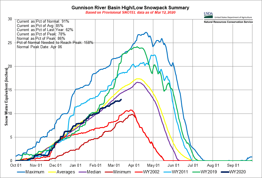
As of this week the SNOTEL numbers for the Gunnison Basin are ranging somewhere between the 2018 low and the averages over the past couple of decades.
The basin watershed has an average of about 13 or 14 inches of snow water equivalent and rests at about 103 percent of normal, as opposed to even lower numbers in the Dolores River Basin…
The good news tends to be the level of the reservoirs, like Blue Mesa and Ridgway…
Following the trends of snowpack and precipitation, stream flow forecasts predict considerably higher values across Northern Colorado than in the southern half of the state, with respect to normal. On the low end the average of forecasts in the combined San Miguel, Dolores, Animas, and San Juan basins is for 64 percent of normal, followed closely by the Rio Grande at 68 percent.
The Gunnison is doing a little better with all forecast points averaging out to 72 percent of normal. The most plentiful forecasts in the state reside in the South Platte Basin with some exceeding 130 percent of average in the main stem headwaters. The Arkansas, Colorado, and combined Yampa and White basins are forecasted to have near normal runoff volumes with the basin-wide average of forecasts ranging from 96 to 106 percent of normal.