Here at 12,000 feet on the Continental Divide, only vestiges of the winter snowpack remain, scattered white patches that have yet to melt and feed the upper Colorado River, 50 miles away.
That’s normal for mid-June in the Rockies. What’s unusual this year is the speed at which the snow went. And with it went hopes for a drought-free year in the Southwest.
“We had a really warm spring,” said Graham Sexstone, a hydrologist with the United States Geological Survey. “Everything this year has melted really fast.”
The Southwest has been mired in drought for most of the past two decades. The heat and dryness, made worse by climate change, have been so persistent that some researchers say the region is now caught up in a megadrought, like those that scientists who study past climate say occurred here occasionally over the past 1,200 years and lasted 40 years or longer…
Normally, Dr. Sexstone said, measurements of stream flow at gauges in the region would slowly climb to a peak and then drop off gradually as the season progressed.
“This year it seemed like it peaked and then plummeted,” he said.
Becky Bolinger, a drought specialist at Colorado State University and the assistant state climatologist, said the lack of new snow in late spring affected the rate of melting. As snow is exposed to the sun it warms and nears the melting point. If new snow falls, that lowers the temperature, stalling the process. But without any new snow, the melting continues unimpeded…
Early, rapid melting of snowpack has been common recently in the Rio Grande basin, said Shaleene B. Chavarria, a hydrologist with the United States Geological Survey in New Mexico. Being farther south, it is hotter and more arid than much of the Colorado basin…
It’s not just the basins west of the Continental Divide that have experienced severe drought made worse by warming. A study published in May about the country’s largest river basin, the Upper Missouri, where snowmelt on the eastern side of the divide at Loveland Pass eventually ends up, showed that warming has affected runoff over the last few decades and increased the severity of droughts, including one from 2000 to 2010…
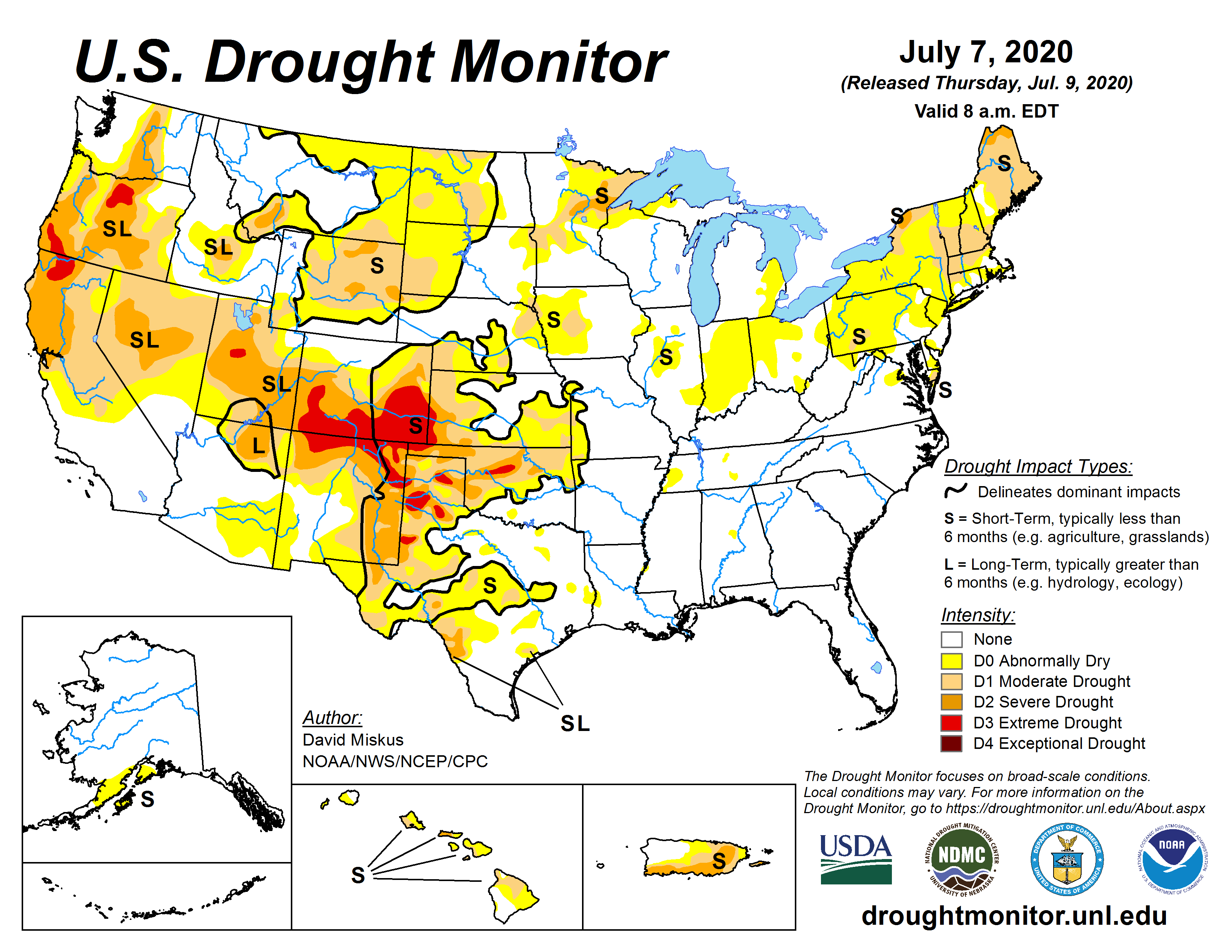
US Drought Monitor July 7, 2020.
In [the U.S. Drought Monitor’s] latest analysis, the monitoring group reported that the southern half of Colorado, northern and eastern New Mexico, Northern Arizona and nearly all of Utah were in moderate to extreme drought, with varying degrees of water shortages and crop and pasture damage. And the National Oceanic and Atmospheric Administration, in its most recent climate forecast, said the drought would likely persist through the summer.
Park Williams, a bioclimatologist at Lamont-Doherty Earth Observatory, was the lead researcher on a study published in April that found that conditions in the Southwest from 2000 to 2018 were comparable to several megadroughts since A.D. 800. It said global warming caused by human emissions of greenhouse gases was a major contributor, turning what would have been a moderate drought into an “emerging megadrought.”
At the time the study was published, Dr. Williams said, there was a possibility that a wet May would “bail 2020 out” and perhaps be the beginning of the end for the drought.
Drought can be complex, a function not only of high temperatures and lack of precipitation but also of factors like humidity, wind and cloud cover. Soil moisture and evaporation of water from the ground surface and from the leaves of vegetation, a process called transpiration, are important.
Dust that settles on snow can have an impact, by absorbing sunlight and warming, which speeds melting. And sublimation, by which a solid (snow) directly becomes a gas (water vapor), bypassing the liquid phase (water), plays a role as well.
But scientists are still learning how these various factors interact, and the relative importance of each. In some cases there is little data to analyze, and much of the research relies on computer models.
There are relatively few direct measurements of soil moisture, for example, even though it can greatly affect runoff as it likely did this year in the Southwest.
Soils were already very dry last fall, Dr. Bolinger said, because the annual late-summer rains in Arizona, New Mexico and Southern Colorado largely failed to materialize.
As winter set in, the soil froze, remaining dry while the snow built up on it. Then, once the snow began to melt, the soil had to be replenished first, Dr. Bolinger said.
Dr. Sexstone’s work to better understand snowpack is part of a broader effort within the geological survey to more accurately quantify and forecast runoff, given increasing uncertainty about water supplies in a warming and more drought-prone world.
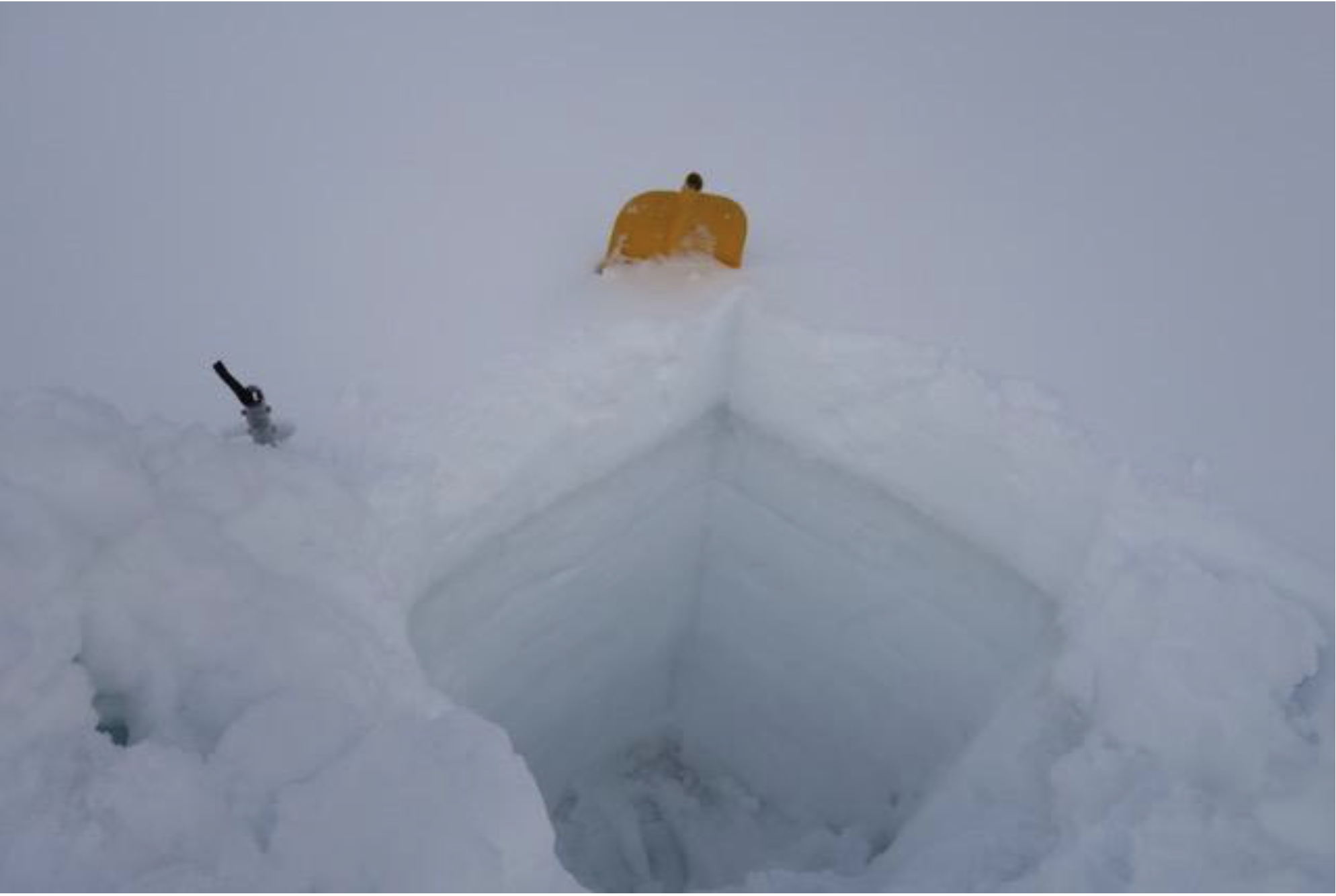
A snow pit on Loveland Pass shows a narrow stripe of dust near the surface. When it’s exposed, the dust can speed up melt off by a couple weeks. Photo credit: Center for Snow and Avalanche Studies via KUNC
At Loveland Pass, with a light dusting of snow falling around him, he demonstrated a basic technique used to study snowpack. Pulling a shovel from his backpack, he dug a pit in a patch of snow down to solid ground. In this case the pit was only 3 feet deep, but in midwinter in the mountains they can reach up to 15.
Dr. Sexstone then inserted thermometers at various levels in the side of the pit, and, using a scoop and a scale, took samples of the snow at each level. By weighing each sample he could determine its density and how much water would result when it melted.
Last winter, Dr. Sexstone was digging snow pits as part of development work on a project, the Next Generation Water Observing System, to better measure snowpack and stream flows at sites around the Upper Colorado Basin and, through modeling, improve basin-wide assessments of runoff.
“We’re looking at more intensive monitoring within the basin,” said Suzanne Paschke, who manages the project at the geological survey’s Colorado Water Science Center. Installation of advanced sensors to measure snow and other characteristics like soil moisture is expected to begin next year.
Most current snow measurements come from a network called Snotel, first established in the 1960s. It now includes hundreds of sites around the West.
While the Snotel network provides invaluable data about snow depth and how much water it holds, Dr. Sexstone said, the sites are all below the tree line and the system was developed when much less was known about what affects snowpack.
“When they were developing this network, they wanted to find sites that weren’t influenced by all these other factors like wind,” Dr. Sexstone said. Scientists have since realized that snowpack and runoff are a lot more complicated.
“Now we’re starting to say, OK, how do we account for all this other stuff?” he said.