Colorado water quality regulators have issued a cease and desist order to the owner of two hard-rock mines located just outside the town of Nederland, alleging the mines have discharged potentially hazardous pollutants well in excess of permitted levels into nearby watersheds.
The Colorado Department of Public Health and Environment’s Water Quality Control Division issued a notice of violation on Nov. 5 to Grand Island Resources, LLC, which acquired the Cross and Caribou Mines in western Boulder County after the death of former owner and miner Tom Hendricks in 2020.
The violation notice came after a series of compliance advisories were sent to the company over the summer. The November notice alleges a failure to comply with current water quality standards, citing multiple excess effluent discharges of heavy metals during the months of December 2020 to August 2021, as well as a failure to comply with required reporting of additional water pollutants.
GET THE MORNING HEADLINES DELIVERED TO YOUR INBOX
Pollutants listed in the violation for exceeding the daily or monthly limits included lead, copper, zinc, silver and cadmium, with the self-monitored data showing several occasions where effluent discharges exceeded levels by up to three or four times the permitted amounts.
Grand Island Resources is currently permitted through the state to release treated wastewater via one outfall into Coon Track Creek within the specified effluent limits. The need to stay within these limits is underscored by the fact that the small creek serves as a tributary in the Boulder Creek watershed, ultimately joining another creek through the town of Nederland and flowing into the Barker Reservoir, one of several potable water sources for the city of Boulder.
In high concentrations, heavy metals are well documented to cause impacts to the environment and human health, including the ability to accumulate in the body over time and cause disease. Critically, the 2021 report of Boulder’s drinking water quality — which employs data from 2020 — reported no violations for lead or copper levels, and no public health advisories have been issued to date.
Direct water quality testing for the natural spring located off Caribou Road — a spring often utilized by locals and recreational visitors — was not immediately available, nor was the immediate source of the spring known.
Representatives of Grand Island Resources did not respond to requests for comment.
This is not the first time compliance advisories or notices of violations have been issued by CDPHE for the Cross and Caribou Mines. Publicly available documents show repeated enforcement actions regarding either excess effluent discharge or a failure to comply with reporting standards of treated wastewater dating back to the 1980s under previous ownership.
The current notice of violation for heavy metal water contaminants comes as Grand Island Resources is seeking revision of its current state permit, having filed for review with the Division of Reclamation, Mining and Safety, a branch of the state Department of Natural Resources, on Feb. 8. No determination has been made to date, with a pending response required from the mining company to proceed. At the same time, the notice of violation has been scheduled for a hearing before the Colorado Mined Land Reclamation Board on Dec. 15 to 16.
Grand Island Resources is also currently operating under a special use development agreement with the county of Boulder, according to Jesse Rounds, a senior planner with Boulder County Community Planning and Permitting. Rounds explained that this agreement is separate from the state mining permit and was acquired in the transfer of mine ownership.
According to Rounds, so long as the existing agreement is upheld, the agreement remains in place indefinitely. However, the county is now currently reviewing if the requested modifications to the state would continue to uphold the existing special use agreement, or if a full special use review may be necessary.
The Cross and Caribou Mines were once estimated to potentially be worth billions of dollars in gold, raising questions as to the long-term scale of mining to be conducted by the new company, and the subsequent implications for Boulder County.
“Mining has had an enormous impact on Nederland’s history,” Nederland Mayor Kris Larsen said in an interview. “It’s why our town exists in the first place, and I have no doubt that it will continue to be part of our future as the demand for domestically sourced minerals is only going to grow. But it can’t be done like it’s been done. It has to be done in a responsible way that protects our air, water, and common environment.”
SUPPORT NEWS YOU TRUST.
Colorado Newsline is part of States Newsroom, a network of news bureaus supported by grants and a coalition of donors as a 501c(3) public charity. Colorado Newsline maintains editorial independence. Contact Editor Quentin Young for questions: info@coloradonewsline.com. Follow Colorado Newsline on Facebook and Twitter.
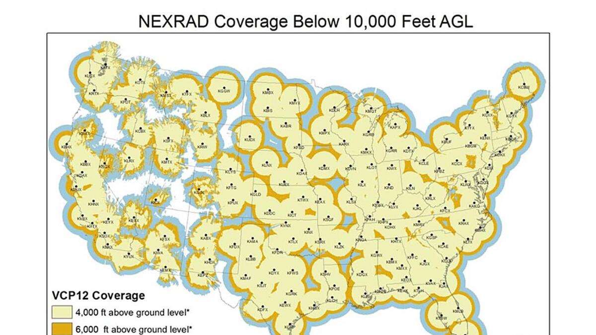
The Four Corners has a radar problem. The San Juan Mountains block signals from the nearest National Weather Service office in Grand Junction, leaving the region blind to low-elevation storms.
A proposed radar project in La Plata County meant to fill in data gaps has been in the queue since 2019 after the Colorado Department of Local Affairs awarded the county $1.7 million to construct a new radar system.
Location problems have stalled the project, but the continued push for radar has raised concern about another issue: climate data gaps.
A 2017 National Oceanic and Atmospheric Administration map shows radar coverage across the U.S. A new radar system in La Plata County was supposed to decrease coverage gaps, but the project has yet to come to fruition. (Courtesy of National Oceanographic and Atmospheric Administration)
Southwest Colorado has fewer weather monitoring stations than the East Coast and other parts of the U.S., according to Colorado state climatologist Russ Schumacher.
“The issue is more acute in the West where it’s more sparsely populated and the complex terrain makes the weather and climate so complicated,” he said. “Ideally, you’d have lots and lots of data quantifying what’s happening at all of these locations because they can vary quite a bit from place to place.”
Climate scientists rely on monitoring stations and the continuous data they collect over years to understand how the climate is changing. But in Southwest Colorado few weather stations have been collecting data long enough or consistently enough for scientists to determine how climate change is affecting communities in the region…
Scientists create 30-year “climate normals” to understand the typical climate of a place. They use these normals, which include temperature, precipitation and other variables, as a baseline to compare daily weather, predict future conditions and assess climate change.
To create these normals, or to determine any climate change trends, scientists need at least 30 years of continuous data.
In Southwest Colorado, few monitoring stations have been running continuously for that long. Many have only been placed in the last two or three decades.
Durango-La Plata County Airport’s temperature data extends back to 1996 and its precipitation data to 2000, according to the National Oceanic and Atmospheric Administration’s NOWData.
Ignacio’s NOAA weather monitoring data dates to 2000.
Mancos has data that dates back to 1898, but it has significant gaps in years of coverage. The station has been continuously recording temperature since only 1997 and precipitation since 2013.
Without this data, climate scientists can’t create climate normals or establish trends as the planet warms. Models that rely on this on-the-ground data become less accurate…
Climate researchers turn to other weather stations in the region to understand how the climate is changing.
Mesa Verde National Park, which has been consistently recording data since 1922, and Cortez, which has been consistently recording data since 1930, are two stations that Schumacher and his team at the Colorado Climate Center use to study climate change in Southwest Colorado…
Though climate scientists know broadly how climate change is affecting, and will affect, Southwest Colorado, the data gaps in the region have significant consequences.
Water managers could use localized climate data to better understand how climate change is affecting the flow of water, allowing them to notify water users of potential shortages and make decisions about infrastructure projects.
City and county managers who plan years in advance could incorporate climate change into their analyses…
The gaps in climate data are perhaps most visible with drought and water resources.
“Climate data is crucial for understanding drought. Because anytime that we’re trying to analyze a drought, we’re measuring it against what has happened before,” said Peter Goble, a climatologist and drought specialist with Colorado State University’s Colorado Climate Center.
According to the most recent National Climate Assessment released in 2018, rising temperatures will worsen drought in the western U.S. as snow shifts to winter rain and soils dry out. Droughts will be more severe and may become more frequent.
Drought driven in part by increasing temperatures shrunk Colorado River flows by 19% from 2000 to 2014, a 2017 study by the Colorado River Research Group showed…
The IPCC’s most recent report released this year found more direct links between global drought and human-caused climate change over the last 120 years, but it concluded that “projecting regional water cycle changes remains challenging.”
Making informed forecasts
Filling in the data gaps in Southwest Colorado and elsewhere would help climate scientists learn more about regional water cycles and ultimately develop projections.
For water managers, that information is critical.
“I wish we could look one year ahead as far as climate and know what we were going to get,” said Steve Wolff, general manager of the Southwestern Water Conservation District.
“There are some tools that look one month and three months out. They are not really accurate at best,” he said. “… For accuracy, we’re stuck to that seven to 14 day forecast.”
The information that climate scientists could glean from more data would help Wolff and other water managers make difficult decisions and prepare for worsening climate change…
Efforts to close the climate data gaps in Southwest Colorado are ongoing.
Schumacher, Goble and the Colorado Climate Center have been expanding their monitoring network, including Colorado State University’s Agricultural Meteorological Network (CoAgMET), which measures soil temperature, precipitation, wind and other variables near irrigated agricultural areas.
Over the last 40 years, the U.S. Department of Agriculture’s Natural Resources Conservation Service has grown its automated snow telemetry network (SNOTEL) across the West. The SNOTEL network now has more than 900 high-elevation sites that collect snowpack, temperature and other climactic data, data that is crucial for water managers like Wolff.
In 2019, a team of scientists founded Airborne Snow Observatories Inc., which uses planes, geospatial technology and other instruments to fly over mountain basins and more accurately assess snowpack and forecast snowmelt.
It’s a new tool that has flourished in recent years, giving Wolff and Schumacher more accurate data with which they can gauge water resources in Southwest Colorado and statewide.
Scientists are even turning to volunteers. The Community Collaborative Rain, Hail & Snow Network (CoCoRaHS), which was initially developed by the Colorado Climate Center in 1998, enlists volunteers across the country to help measure precipitation…
The proposed radar system in La Plata County, which has yet to find a suitable site, according to Stevens, will also help scientists to close climate data gaps…
As climate scientists work to expand their data collection networks, the question becomes one of money. The instruments and equipment needed for monitoring stations can be expensive to buy and maintain.
“As a researcher, I would say the ideal (weather station) density is the more data I can get, the better. If we had stations every half mile or quarter mile, we could find ways to put that all to use,” Goble said.
“But what’s the best practical density is an entirely different question,” he said.
From the Rio Grande Basin Roundtable via The Alamosa Citizen (Chris Lopez):
THE 2015 Colorado Water Plan (CWP) was developed in response to Gov. John Hickenlooper’s 2013 Executive Order and is focused on strategies to address the state’s growing water demands. Alongside the CWP, eight Basin Implementation Plans (BIPs) were also developed in 2015 by the state’s basin roundtables to identify short- and long-term objectives and projects that are critical to meeting each basin’s current and future water challenges.
The original 2015 Rio Grande BIP, developed by the Rio Grande Basin Roundtable (Roundtable), identified several goals aimed at addressing the basin’s major water challenges. Another key focus of the 2015 BIP was identification of projects that would help meet the basin’s water needs and have multiple benefits for water users and the environment.
As conditions change from year to year, updates to the BIP are important. In 2019, the Colorado Water Conservation Board (CWCB) worked with the state’s basin roundtables to initiate the first update to the original BIPs. and the roundtables are currently in the final stages of completing this update. The Rio Grande Basin Roundtable selected a local nonprofit watershed group, the Rio Grande Headwaters Restoration Project (RGHRP) to facilitate the BIP Update process. Led by the RGHRP, the Roundtable formed BIP Update subcommittees, made up of diverse local stakeholders, from local, state, and federal agencies to nonprofits, landowners, and community members. The subcommittees were tasked with developing strategies to meet the basin’s water needs, from agricultural and municipal/industrial water use to water administration and water resources education.
The updated Rio Grande BIP features project accomplishments since 2015, new data and analyses related to the basin’s current and future water use, projects and strategies to meet the basin’s water needs, and updated basin goals. Since the publication of the 2015 BIP, a variety of projects have been completed, many of which were funded in part by the Roundtable. During the BIP update process, more accurate agricultural and municipal water use data and well defined environmental and recreational attributes allowed the Roundtable to identify strategies to meet these water needs. Finally, the updated goals center around healthy watersheds and sustainable surface and groundwater that supports the basin’s communities.
CWCB and the Roundtable are seeking feedback on the draft BIP Update, which is currently available on the website: http://engagecwcb.org This public comment period will remain open through Nov. 15.
In what could be one of the biggest requests to the Legislature in years, state water development officials are eyeing $281 million or more to fund agricultural irrigation works, dams, reservoirs, domestic water projects and other programs.
During three days of meetings last week, lawmakers first advanced about $33 million in appropriations recommended by the Wyoming Water Development Office. Funded projects include a few municipal supply projects, numerous irrigation improvements, cloud seeding and a review of aging infrastructure, among other things.
The Legislature’s Select Water Committee then backed a draft bill seeking an additional $95 million from American-Rescue-Plan-Act or general-fund money to establish a statewide water infrastructure grant program.
Then, in an 11th-hour proposal, the legislative committee asked its staff to draft an amendment — or another stand-alone bill — to add another $152.8 million to 2022 appropriations, mostly for five major agricultural dam, reservoir and irrigation projects.
There could be even more added to the almost $153 million amendment or new bill.
“If people have things that they would like to include in that draft, I think that would be appropriate,” Sen. Larry Hicks (R-Baggs) told Select Water Committee co-chairman Rep. Evan Simpson (R-Afton).
Wyoming has turned a corner since facing a diminished state budget due to declines in coal and oil-and-gas tax revenue, Hicks suggested. There’s “a certain amount of money, funds, available,” he said, pointing to the American Rescue Plan Act that seeks to pull the country out of its COVID-19 slump. Additional funds, possibly from rising oil and gas activity, also could be available, he said.
All of which could be used to shore up a water development program that Hicks has said repeatedly has been unfairly plundered by the Legislature.
“By the time we get through this biennium, we will have raided water development account[s] to the tune of about $55 million,” he told lawmakers last week. In recent years, the Legislature directed funds that should have been used for water development, Hicks said, to instead finance other projects and the State Engineer’s Board of Control, which settles disputes over water rights.
Three avenues for appropriations
The Select Water Committee’s three-pronged agenda would fund the $33 million in 2022 water development commission programs, add the $95 million statewide infrastructure grant program using ARPA and general-fund money and spend another $152 million under Hicks’ water development amendment.
Hicks’ call for $152 million — the largest funding avenue — could be added to the ARPA bill or emerge as a separate stand-alone measure, according to discussion by the committee. It would see $35 million go toward the Alkali Reservoir near Hyattville in Big Horn County, the cost of which has increased from $35 to $59 million.
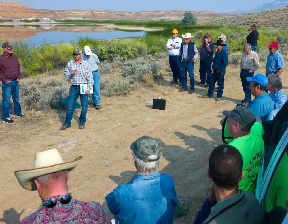
Jason Mead in 2015 describes to irrigators and others the plans for expanding the Upper Leavitt Reservoir in Big Horn County. (Angus M. Thuermer, Jr./WyoFile)
Another $30 million would go toward the Leavitt Reservoir expansion, an additional $25 million would armor the Fontenelle Dam to increase its usable capacity and $21.8 million more would help resolve the collapse of the Goshen irrigation tunnel.
Hicks’ proposed amendment or stand-alone bill also would earmark $30 million to help rebuild the dangerous LaPrele Dam above Douglas. The proposed appropriation also would infuse several other water development accounts with $11 million.
The next largest block of funds advanced by the Select Water Committee last week — $95 million from ARPA money for a statewide infrastructure grant program — would be disbursed by the Wyoming Water Development Office in coordination with two other state agencies. The Office of State lands and Investments, which oversees drinking water funds, and the state Department of Environmental Quality, which is responsible for aspects of wastewater projects and discharges, would be involved with the grants.
Grants would be limited to $7.5 million per project and they would cover 85% of the cost of a proposal.
Funds appropriated through the ARPA bill could be constrained by the caveats in that federal rescue program, however. The federal emergency COVID-19 relief program funds water infrastructure programs that appear to be directed mainly toward domestic and municipal drinking water and wastewater programs, not agricultural and irrigation dams, reservoirs and canals.
ARPA funds are being distributed according to an interim rule that in one clause specifies investments will be made for “projects that improve access to clean drinking water [and] improve wastewater and stormwater infrastructure systems.”
The Select Water Committee’s third avenue for funding grew from the Water Development Office and Commission’s annually scheduled advancement of water programs that this year totals about $33 million. Those projects involve everything from new and ongoing cloud seeding and a review of its effectiveness to municipal and domestic water supply projects, irrigation and agricultural programs and a statewide assessment of crumbling infrastructure.
What about the infrastructure bill?
During last week’s meetings there was little if any discussion regarding the $1 trillion infrastructure bill President Joe Biden signed into law Monday. But earlier this year the Select Water Committee wanted that measure to include provisions for water development in the state.
“As we start to see an infrastructure bill develop … it’s certainly something that we’ve conveyed to our congressional delegation that water is a big issue in Wyoming,” Hicks said in April, “and that we’d like to see a significant component in any infrastructure bill.”
Although he stopped short of endorsing the federal infrastructure bill, Hicks asked Wyoming legislative staff to stay in touch with the congressional delegation in Washington, D.C., and to get updates.
On Aug. 10, U.S. Sens. John Barrasso and Cynthia Lummis provided one public update when they voted against the infrastructure bill, which passed the Senate 69-30. On Nov. 5, U.S. Rep. Liz Cheney also voted against the infrastructure bill as the measure passed the House 228-206.
To further buttress water development and prevent what developers see as a raid on funds, Hicks and Wyoming Water Development Office Director Brandon Gebhart in April proposed an explanatory program to be presented to “anybody willing to listen.”
Such a presentation may “enlighten some people in the Legislature,” Gebhart said. Hicks called the planned presentation “education” for lawmakers and said it should come during the first day or two of the 2022 legislative session.Last week’s funding proposals did not include several other ongoing projects — including a proposal to build a 280–foot-high dam on the West Fork of Battle Creek above the Little Snake River in Carbon County, and a plan to lower New Fork Lake by some 21 feet to provide late-season irrigation. While those were not immediately included in Hick’s amendment, they are on a $414-million wish list of water infrastructure projects reviewed by WyoFile that the state assembled earlier this year.
WyoFile is an independent nonprofit news organization focused on Wyoming people, places and policy.
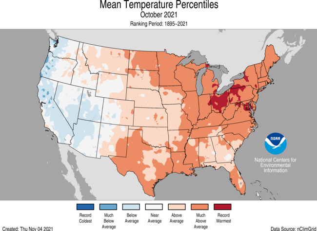
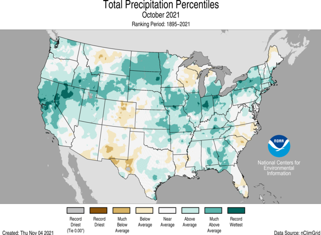
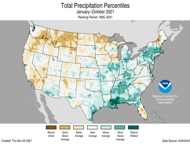
Precipitation was the star of the show across the contiguous United States in October 2021, according to the latest monthly climate summary by NOAA’s National Centers for Environmental Information. Much of the country received more than 100 percent of their average precipitation, and in many states, precipitation totals were much higher than average. Overall, the month ranked ninth-wettest October in the historical record.
Total precipitation across the contiguous United States in October 2021. Places that received little to no precipitation are pale green; places that received 8 or more inches of precipitation are dark blue. Map by Climate.gov, based on data from NOAA’s National Centers for Environmental Information.
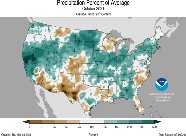
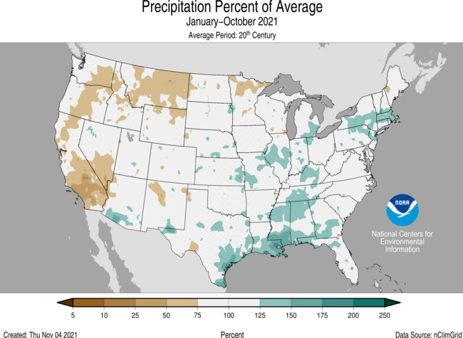
On the West Coast, much of the above-average precipitation came in the form of atmospheric rivers—temporary, well-defined bands of water vapor that stretch like a river from the tropics or subtropics to higher latitudes and which are pushed along by strong winds. At least one of the events, taking place on October 24, was ranked as a “Category 5” event by researchers at the Western Weather and Water Extremes group at Scripps Institution. Parts of the state set a new record for wettest 24-hour period. Meanwhile, the East Coast was battered by a Nor’easter that generated heavy rain, flash flooding, and power outages in the coastal Mid-Atlantic.
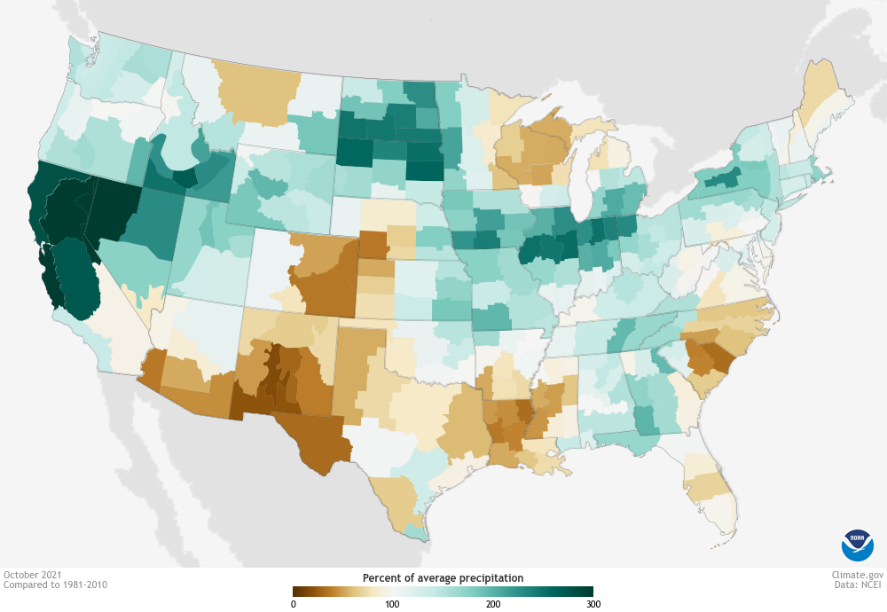
Precipitation across the Lower 48 in October 2021 as a percent of average. Places that received less than 100 percent of their average October precipitation are brown; places that received more than 100 percent of their average precipitation are blue-green. Map by Climate.gov, based on data from NOAA’s National Centers for Environmental Information.
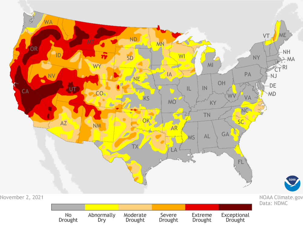
The soaking of multiple Western states—California, Oregon, Washington, Nevada, Idaho, and Wyoming—provided some relief in the intensity of the long-lasting drought that has parched the region over the past year. Still, nearly half the contiguous United States was in some level of drought at the start of November, and it intensified in locations that were missed by the month’s generous precipitation, including parts of Texas, eastern Colorado, Michigan, and the Carolinas.
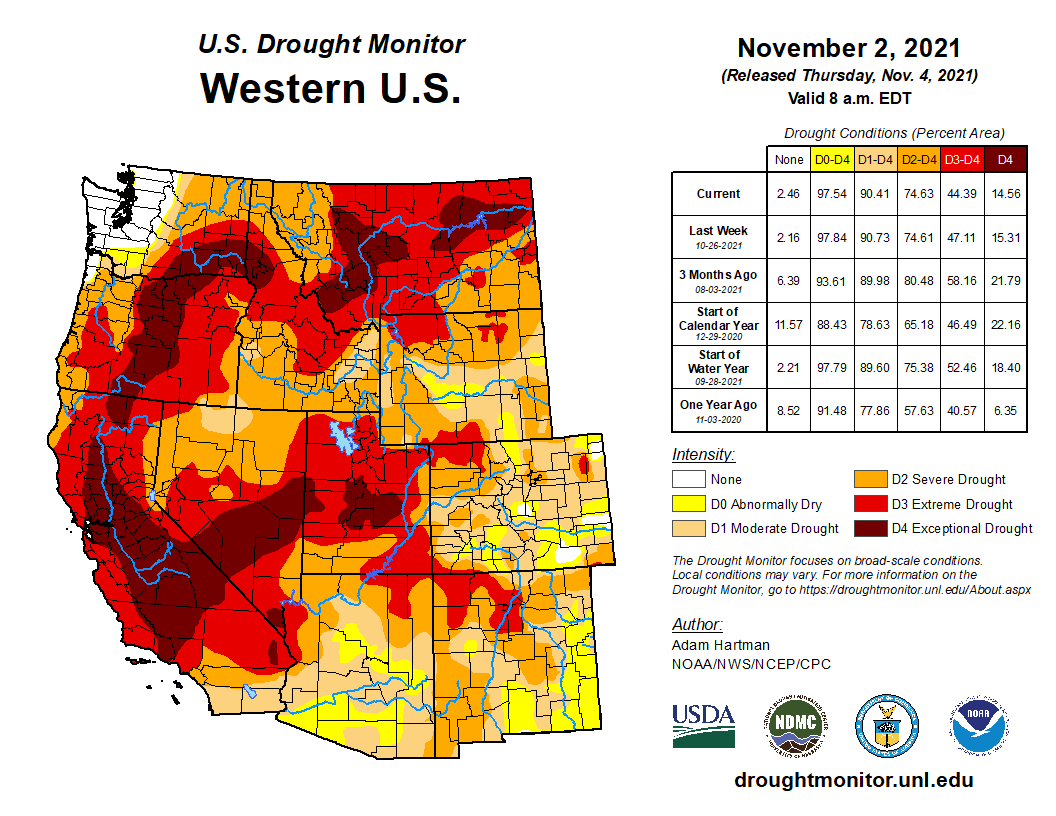
Drought conditions across the Lower 48 as of November 2, 2021. Despite generous October rainfall, many states in the West remained in a state of extreme to exceptional drought. NOAA Climate.gov, based on data from the U.S. Drought Monitor project.
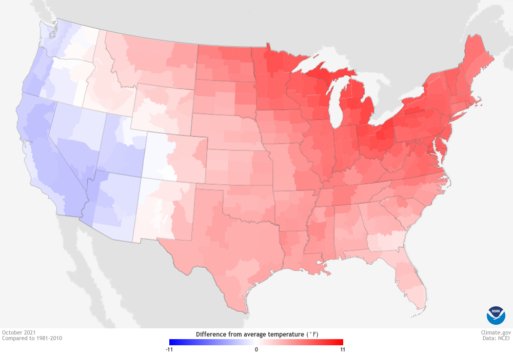
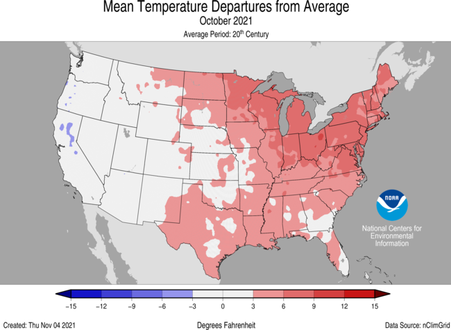
According to NCEI, the average temperature across the Lower 48 was the sixth-warmest on record, 2.9 degrees Fahrenheit (1.6 degrees Celsius) warmer than the 20th-century October average of 57.0 degrees. The warmth was widespread, stretching from the Rockies all the way to the East Coast. However, October was cooler than average for the West Coast part of the Southwest.
Temperature across the contiguous United States in October 2021 compared to the 1981-2010 average. Places that were warmer than average are red; places that were cooler than average are blue. NOAA Climate.gov map based on data from NOAA’s National Centers for Environmental Information.
For more details on the U.S. climate in October, see NCEI’s State of the Climate report. For more information on drought conditions, visit Drought.gov.
Here’s the release from the Colorado Department of Natural Resources (Chris Arend):
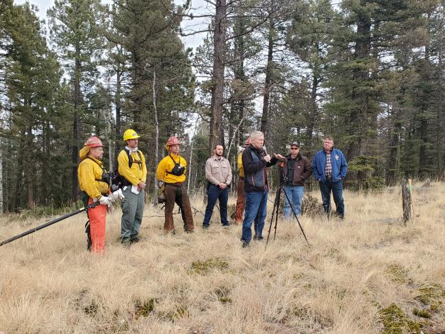
The Colorado Department of Natural Resources (DNR) announced today the launch of the Colorado Strategic Wildfire Action Program and highlighted the special collaboration with their partners, the Department of Corrections (DOC), State Wildland Inmate Fire Team (SWIFT).
Colorado Strategic Wildfire Action Program (COSWAP) was created after the devastating 2020 fire season by the Colorado legislature through the bi-partisan supported SB21-258. COSWAP is designed to quickly move state stimulus funds to start on-the-ground work on fuels reduction projects including funds for landscape scale strategic wildfire mitigation projects in strategic wildfire prone communities in Colorado.
“Colorado is one lightning strike, one unattended fire, and one drought season away from our next mega fire, said Dan Gibbs, Executive Director, Colorado Department of Natural Resources. “The devastating 2020 fire season taught us that the status quo of our forest health and wildfire mitigation programs were no longer going to cut it and our state and federal partners needed to do more, and quickly.”
“Thanks to the leadership of Governor Polis, bi-partisan support in the Colorado legislature, and strong inter-agency collaboration, we have launched the Colorado Strategic Wildfire Action Program, identified priority areas, and are going to be moving funds to on-the-ground projects and deploying hand crew teams from CDOC and the Colorado Youth Corps within months of legislation being signed”, Gibbs added.
The COSWAP is housed under DNR in coordination with the Colorado State Forest Service (CSFS) and the Division of Fire Prevention and Control (DFPC) in the Department of Public Safety. It includes a special collaboration with State Wildland Inmate Fire Teams (SWIFT) within the Department of Corrections (DOC) and Colorado Youth Corps Association (CYCA) to be deployed as hand crew teams to jump-start critical on-the-ground forest health and wildfire mitigation work throughout Colorado.
“We are excited about the opportunity to partner with DNR to not only provide an important public service through this mitigation work, but also to offer incarcerated individuals an opportunity to gain skills, save money, and prepare for a successful re-entry into the community once their sentence is complete,” said DOC Executive Director Dean Williams. “Many of these crew members have responded to some of the largest natural disasters in the state and they find purpose and dignity in the work they do. With the increased risk of fires in Colorado and across the nation, we know that this partnership with DNR will help provide critical support.”
Since its inception in 2002, SWIFT crews and fire mitigation teams have been involved in relief for most of Colorado’s biggest disasters. From the devastating Northern Colorado floods to the recent Cameron Peak (2020) and Morgan Creek (2021) Fires, these teams have helped to safeguard land, life and homes. There are currently 95 incarcerated individuals who are working in the SWIFT program. The Department anticipates increasing the number of crews to include 160 incarcerated individuals to help meet project needs.
In addition to fighting fires, the crews are trained in sustainable mitigation development and maintenance following the standardized methods of construction commonly used by state, federal and local land management agencies. The crew members bring knowledgeable and willing hands to the task.
“Developing partnerships with agencies such as Dept of Natural Resources, Colorado Parks and Wildlife, Colorado State Forest Service, Dept of Corrections and local counties is critical in accomplishing forest health and fire mitigation goals within Teller County. And let’s not forget private land owners whether they own 1 acre or 500 acres. Collaboration is the key to accomplishing such large projects,” said John Geerdes, Executive Director, Coalition for the Upper South Platte. “Coalition for the Upper South Platte is a non-profit that is primarily grant funded and focuses on pre-fire mitigation, forest health, post fire rehabilitation and more. We have used SWIFT crews in the past when our work called for hand crews rather than mechanical thinning. They have always done an outstanding job for us and I look forward to ways we can use them in the future under this new program.”
A key aspect of the COSWAP was the formation of a Rapid Fuels Reduction Assessment (RFRA) team which was a unique partnership composed of experts from the Department of Natural Resources, Colorado State Forest Service, Division of Fire Prevention and Control, U.S. Forest Service, Bureau of Land Management, National Parks Service, and the Colorado Forest Restoration Institute at Colorado State University.
The team was instigated by a bi-partisan letter from state, federal, and federal representatives asking for federal resources and partnership to address Colorado’s pressing forest health and wildfire mitigation challenges.
The RFRA team conducted a comprehensive risk analysis to identify the most strategic landscapes in the state for wildfire mitigation and fuel reduction projects.
Strategic Focus Areas include: Boulder, Douglas, El Paso, Jefferson, Larimer, La Plata and Teller counties, plus Rocky Mountain Restoration Initiative focal areas.
The pilot project at Dome Rock State Wildlife Area highlighted an important initiative for Colorado Parks and Wildlife to conduct forest health projects that will benefit important wildlife habitat while also providing important thinning and mitigation work to protect local communities at risk.
“This work at Dome Rock will improve the habitat for bighorn sheep that lamb in the wildlife area,” said Cody Wigner, CPW Area Wildlife Manager for the Pikes Peak region. “Thinning will open up the forest canopy and create greater visibility for the sheep and other wildlife. That will make them more comfortable and more likely to use the wildlife area because they can spot predators more easily. Improved habitat means more wildlife which is the ultimate goal for our state wildlife areas.”
SB21-258 was a result of priorities set out in the Colorado Recovery Plan by the Governor and the Colorado legislature, allocating a total of $25 million of stimulus funds to immediately address Colorado’s forest health and wildfire challenges. The $17 Million for COSWAP project implementation included more than doubling DOC SWIFT crews and significantly increasing Colorado Youth Corps forest health mitigation work throughout Colorado. A large portion of funds will also go to landscape-scale wildfire mitigation projects conducting critical work such as reducing hazardous fuels, forest thinning, developing fuel breaks and clearing evacuation routes. All funds must be obligated by June 30, 2023.
Additional SB21-258 funds gave long-term sustainable support to the Colorado State Forest Service Forest Restoration & Wildfire Risk Mitigation (FRWRM) Grant Program, a complimentary fund and new investment for CSFS Forest Business Loan Fund to support Colorado timber businesses. Additionally the bill called for an organizational assessment of state wildfire mitigation programs which also will be led by staff from DNR in partnership with the Colorado State Forest Service and Division of Fire Prevention and Control.
“This partnership represents the best of the Colorado spirit, putting young people to work while protecting the lives and livelihoods of millions of Coloradans,” said Scott Scott Segerstrom, Executive Director, Colorado Youth Corp Association. “This investment from DNR will help build the next generation of wildland firefighters, grow our outdoor recreation economy, and respond to the existential threat of climate change. Young people serving in their local communities for the benefit of all is something for which every Coloradan can be proud.”
The $1.2 trillion infrastructure bill signed by President Joe Biden yesterday will include full funding for efforts to provide clean water to tribal nations.
Over the next five years $3.5 billion will head to the Indian Health Services water and sanitation construction program to pay for tribal clean water projects.
On top of that, the infrastructure bill increases funding to the Environmental Protection Agency’s clean water programs, which will leave $868 million for tribes to build on or create better water treatment systems, along with training and technical assistance.
One proposal missing from the massive federal infrastructure package is the proposal by Rep. Melanie Stansbury for $200 million that would have fully funded the Rio Grande Pueblos Irrigations Improvement Project. The amendment was cut during negotiations in the House.
“Pueblo leaders in our district and beyond identified the need for long-overdue funding for Pueblo irrigation systems,” Stansbury said in a statement. Despite the funding being axed from the final bill Biden signed yesterday, there is still more than $440 million for tribal climate programs and $25 million for tribal drought projects. “We will keep working to secure funding in partnership with our Pueblo and tribal nations,” Stansbury said.
Navajo Nation President Jonathan Nez praised the funding that will come to tribal communities.
“Safe drinking water is a basic human need, and the consequences of not having access to reliable potable water supplies are long-lasting and destructive,” he said.
“In the most powerful country in the world, as many as 40% of homes on the Navajo Nation lack this essential service that most Americans take for granted.”
– Jonathan Nez, Navajo Nation President
The money is welcome and just the first step in a list of solutions brought forth by the Tribal Clean Water Initiative, a group of advocates and tribal officials working on the priorities of a similar effort in the Colorado River basin.
The group is pushing the White House to create a better relationship with tribal government communities by listening and addressing their needs when it comes to water infrastructure.
Their premise is focused on what they call a “whole government” approach that outlines ways for the federal government to have better discussions with tribal governments to better understand their needs.
Heather Tanana is part of the research team with the water initiative and wrote the report that outlines direct goals for change. The full report can be viewed here.
Tanana said tribes being able to operate and maintain drinking water systems is a big part of self-determination.
“Ensuring clean drinking water for Native Americans is part of the unfinished business of our Republic,” she said.
Source New Mexico is part of States Newsroom, a network of news bureaus supported by grants and a coalition of donors as a 501c(3) public charity. Source New Mexico maintains editorial independence. Contact Editor Marisa Demarco for questions: info@sourcenm.com. Follow Source New Mexico on Facebook and Twitter.
The South Platte River Basin is shaded in yellow. Source: Tom Cech, One World One Water Center, Metropolitan State University of Denver.
From email from Sean Cronin:
The St. Vrain and Left Hand Water Conservancy District (SVLHWD) and the Left Hand Water District have announced a new agreement that will allow sharing Colorado-Big Thompson (“C-BT”) project water for the next decade.
The agreement allows the Left Hand Water District to receive critical water supplies for the growing number of people it serves and provide drought protection. This is the first long-term water sharing agreement between the districts.
“Our number one goal is to ensure safe, reliable water for our customers and this helps continue that,” said Christopher Smith, General Manager of the Left Hand Water District. “Water sharing is the future and I am proud of this mutually beneficial agreement that could serve as a model for others,” he added.
The Left Hand Water District will make an annual payment for the option to lease water from St. Vrain and Left Hand Water Conservancy District. In years that the option is exercised, an additional payment based on the amount of available water would be made.
“When the voters approved 7A last year, they said they wanted to protect drinking water,” said Sean Cronin, Executive Director of the St. Vrain and Left Hand Water Conservancy District. “This creative solution reflects what our constituents want: smart, local solutions and partnerships that ensure reliable drinking water for our local communities”.
About the St. Vrain and Left Hand Water Conservancy District
St. Vrain and Left Hand Water Conservancy District (District) was formed in 1971. For fifty years the District has facilitated and implemented water programs and services and takes a comprehensive look at how all these components work together. Specifically, the District protects water quality and drinking water sources, safeguards and conserves drinking water, supports growing of local food, identifies creative solutions for storing water for dry years, and works with partners and leads in efforts to maintain healthy rivers and creeks.
As a local government, non-profit agency formed at the request of our community under state laws, the District serves Longmont and the surrounding land area or basin that drains into both the St. Vrain and Left Hand Creeks.
About the Left Hand Water District
The Left Hand Water District was originally created in 1962 as a private non-profit water supply company and was then established as a division of local government under Title 32 of the Colorado Revised Statutes (CRS) in 1989. With a 7 member Board of Directors and a staff of 27 employees, the District serves a population of over 20,000 people in a 100 square mile area of Boulder and Weld Counties. Of the nearly 7800 individual taps, over 90% serve single and multi-family residential properties.
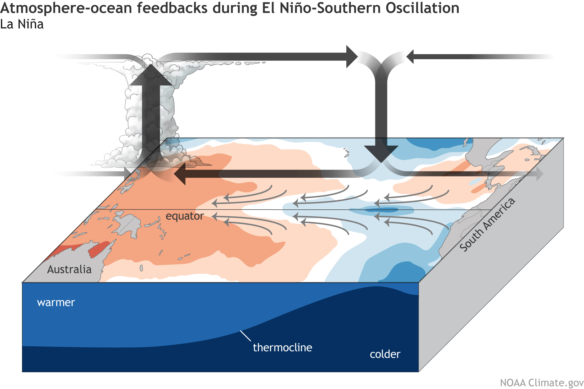
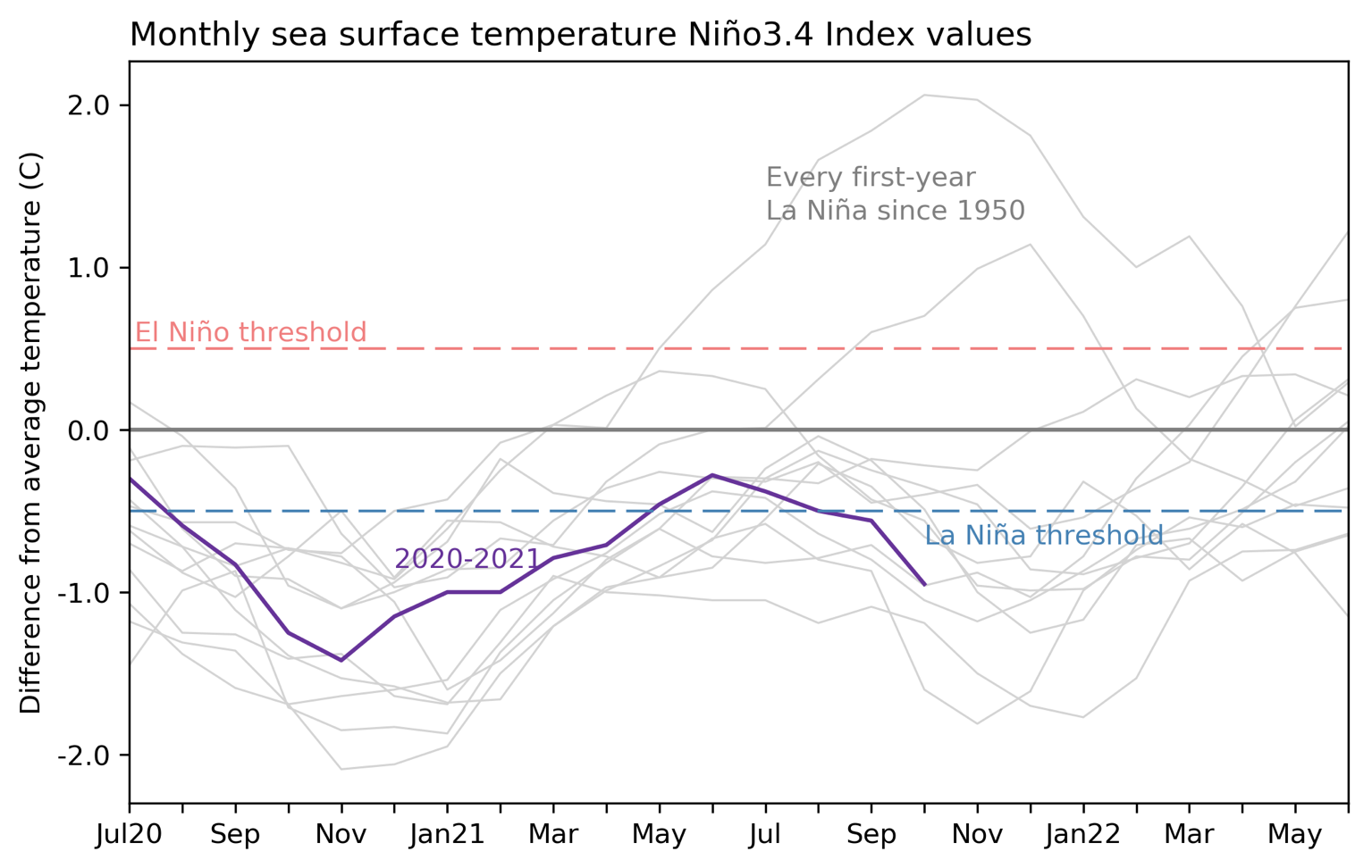
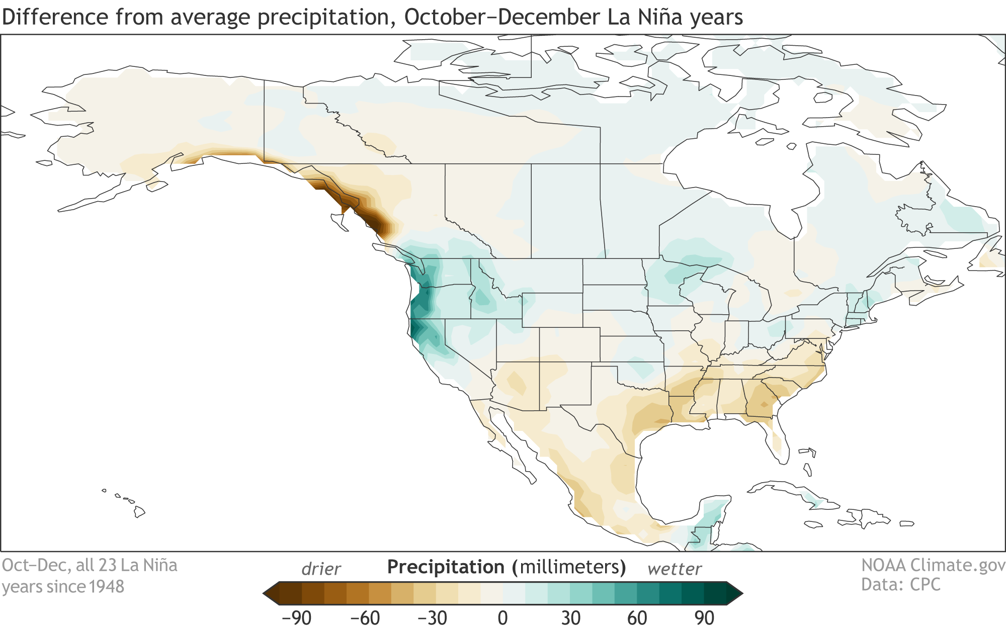
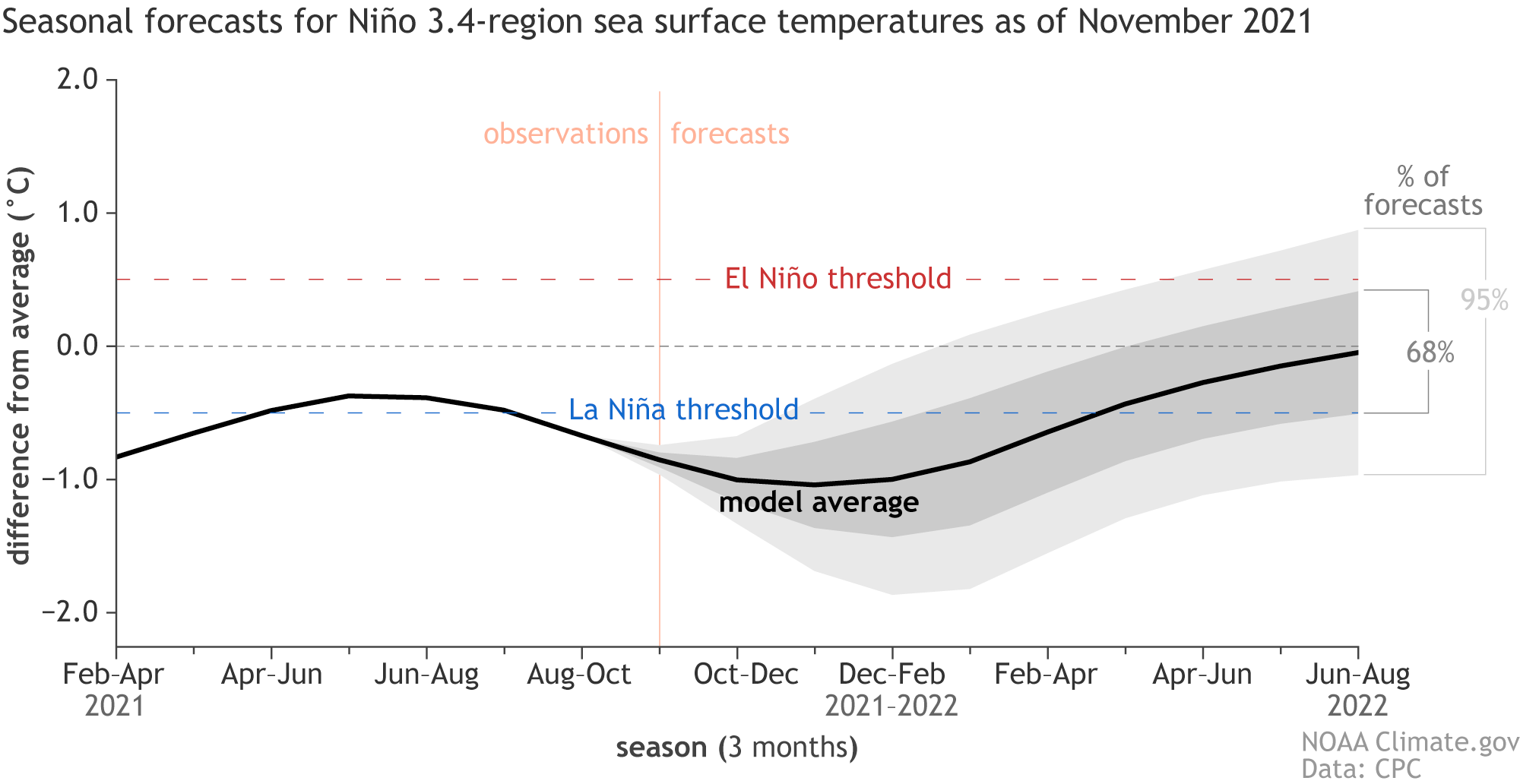
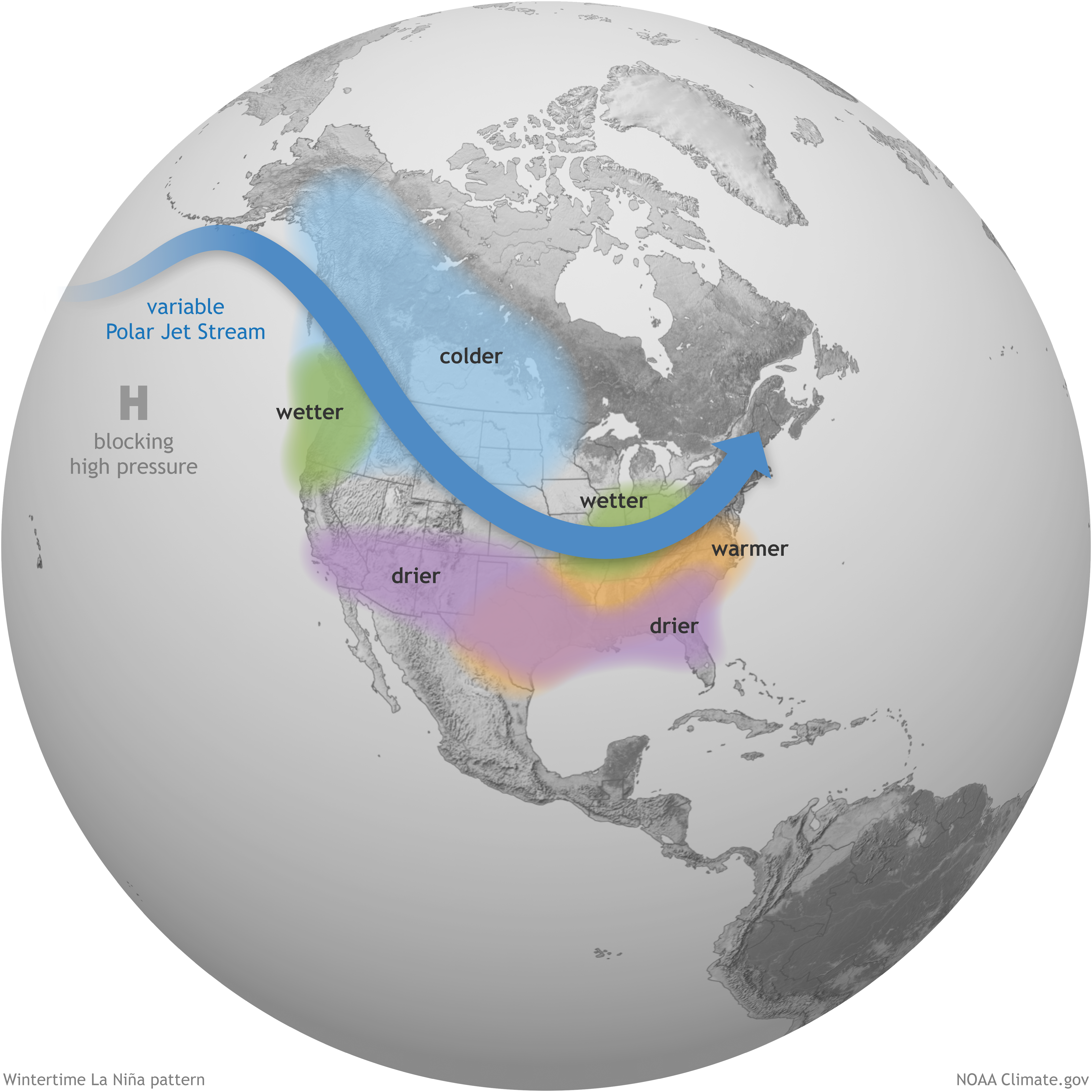
Heading into the cold season w/ La Niña kicking into high gear, the numbers in the south-central US are worrisome – not to mention the lingering issues on the northern High Plains and emerging #drought in the Carolinas.
The utility will pay millions to mitigate environmental concerns for Boulder County residents
The county received assurances Denver Water would pay to mitigate environmental damages expected from the work, but the deal still left Commissioner Matt Jones “heartsick.” He said commissioners fought for the best deal possible but he’s still concerned about the damage the project could do locally and for the millions of people who depend on the Colorado River…
Climate scientists and legal experts said they’re skeptical the parched Colorado River will provide enough water for Denver Water to fill an expanded Gross Reservoir. And even if the water’s there, the expansion and other projects like it will inevitably worsen water shortages on Colorado’s Western Slope and downstream, they said.
Utility officials, however, hailed the settlement and said that while they won’t be able to fill the reservoir every year — which they’ve known all along — years with above-average precipitation will provide more than enough water.
“We’re gonna fill the reservoir,” Denver Water Project Manager Jeff Martin said.
Climate change is trending in the wrong direction for such strong confidence, cautioned Mark Squillace, the Raphael J. Moses Professor of Natural Resource Law at the University of Colorado Law School.
“This just seems a bit insane to me that Denver Water is unwilling to acknowledge” that climate change is only likely to worsen water shortages on the Western Slope, Squillace said.
Martin said he still expects to break ground on the five-year, $464 million project by April…
Denver Water will pay $5 million to residents most impacted by the work and agreed to reduce noise and dust from the project using electric rather than diesel generators.
Denver Water’s drivers must complete bicycle awareness training, provide “truck free” days for cyclists and “leave Gross Dam Road in a better condition than before the project.”
Denver Water will pay $5.1 million to replace open space lands that would be flooded by the reservoir expansion and transfer 70 acres near Walker Ranch Open Space to Boulder County.
Denver Water will pay $1.5 million to reduce greenhouse gas emissions from the project and another $1 million to restore a stretch along South St. Vrain Creek.
Squillace said while those terms might benefit county residents, it’s still not enough and he was disappointed to hear commissioners agreed to settle.
“We were between a rock and a hard place,” Jones said. “We were pushed into this corner of knowing that and trying to figure out what we could get for Boulder County residents…
Martin said he and others at Denver Water expect to be able to fill the expanded reservoir in average and above-average years. South Boulder Creek, which is not part of the Colorado River system, also feeds into the reservoir and could supplement water in dry years on the Western Slope, he noted…
[David] Bahr suggested Denver Water could instead pipe in water from the Missouri River or other places in the Midwest that are expected to see more water in the coming years. While Martin said those types of ideas could be explored for the more distant future, Denver Water officials maintain that an expanded Gross Reservoir is the best course of action for now.
The project could still come to a halt, Squillace said. The more delays the work faces, the more climate data will be available, increasing political pressure for Denver Water to seek another way to secure its water supply.
“I’m still not so convinced that the project’s ever going to actually be built,” he said.
Brad Udall: Here’s the latest version of my 4-Panel plot thru Water Year (Oct-Sep) of 2021 of the Colorado River big reservoirs, natural flows, precipitation, and temperature. Data (PRISM) goes back or 1906 (or 1935 for reservoirs.) This updates previous work with @GreatLakesPeck.
The Crystal River widens and becomes shallower just before it passes under the southern bridge into River Valley Ranch. A group of local organizations is working to restore both the stream and the banks. CREDIT: WILL GRANDBOIS / ASPEN JOURNALISM
The town of Carbondale and the Roaring Fork Conservancy are finalizing funding to restore a half-mile stretch of the Crystal River and 18 acres of riparian habitat — provided they can convince Colorado Parks and Wildlife that it can be done with a light touch.
The location, next to the River Valley Ranch subdivision on the south side of town, is the ideal spot for the effort due to Carbondale’s Riverfront Park on the west side and the headgate for the town-owned Weaver Ditch on the east side, with some associated in-stream impacts.
As spelled out in a Water Plan grant request to the Colorado Water Conservation Board — originally slated for consideration in September but since pushed back to January — improvements will include streambank stabilization and river channel restoration, plant diversification and better access to the park as well as an automated ditch headgate. Efficiency work is ongoing on the ditch itself, but it is not officially part of the project.
The cost of the whole effort was originally estimated at $1,466,478, with roughly half hinging on the Water Plan grant. The multifaceted nature of the project lends itself to a wide array of sources to pay for the rest.
At least eight other agencies have committed funding or are considering grant applications. This includes $100,000 awarded from the Colorado River Water Conservation District in October. Other agencies partnering in the project include the Pitkin County Healthy Rivers Program, Great Outdoors Colorado, Colorado Parks and Wildlife’s Fishing Is Fun Program and the Aspen Valley Land Trust. Carbondale has committed at least $220,000 toward the effort to improve the reach of river described in the Water Plan grant application as “severely to unsustainably degraded.”
The project’s many layers make it a perfect fit for the Roaring Fork Conservancy (RFC), according to Heather Lewin, director of Watershed Science & Policy.
“You’ve got so many different things that we’re interested in doing — a flow issue, a riparian corridor, this older ditch outtake and the potential for efficiencies within the ditch itself,” she said.
Although better access and an outdoor classroom are part of the plan, the majority of the property will remain relatively rustic to provide an authentic outdoor experience and good wildlife habitat. CREDIT: WILL GRANDBOIS / ASPEN JOURNALISM
Reclamation’s November 24-Month Study includes a minimum probable (90% chance of being exceeded), a most probable (50% chance of being exceeded) and a maximum probable (10% chance of being exceeded) forecast. While Reclamation operates to the most probable forecast, the range of outcomes in the forecast is tracked on a monthly basis. The latest forecast and projected operations no longer show a shortage to contract deliveries at the Navajo Unit for water year 2022 under the minimum probable forecast. This projection will continue to be updated monthly as the forecast evolves.
Any projected shortage volume is modeled as a proportional distribution to project users (as per PL-87-483 and PL-111-11) and downstream target base flows (pursuant to the Navajo Reservoir’s Record of Decision, 2006).
In anticipation of increasingly severe drought, the Upper Basin states and Reclamation entered into a Drought Response Operations Agreement in 2019. Under this agreement, Reclamation initiated delivery of supplemental water to Lake Powell from the upper CRSP units beginning in July 2021. The delivery from Navajo Reservoir, originally planned for late November through early December, has been postponed and is currently scheduled as a daily release of 1,300 cfs from December 20th to December 30th for a total of 20,000 acre-ft over our regular release. Reclamation will review this release plan after publication of the December 24-Month Study, currently anticipated mid-December.
We will continue to closely monitor conditions and projections as we work with the seven Colorado Basin states on a Drought Response Operations Plan in the coming months.
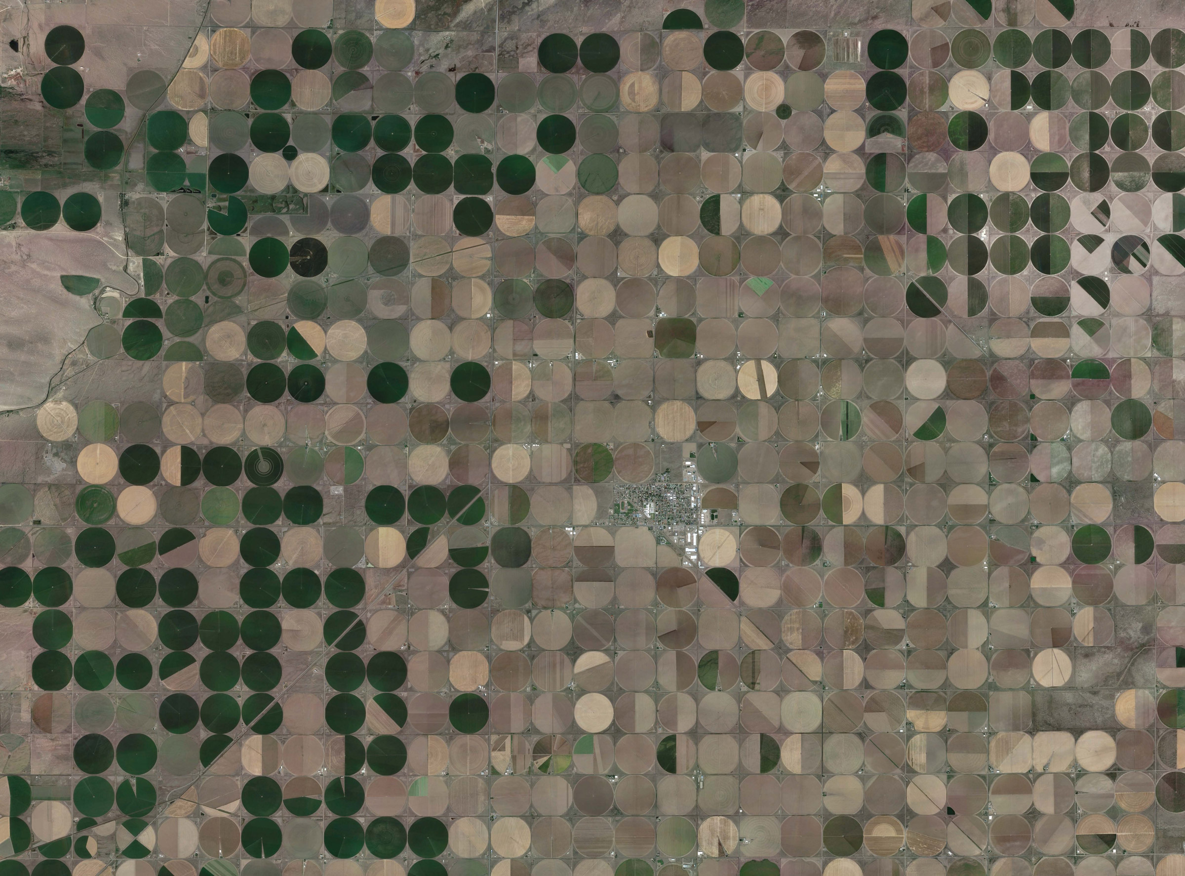
Center, Colorado, is surrounded by center-pivot-irrigated farms that draw water from shrinking aquifers below the San Luis Valley. Photo credit: Google Earth
COLORADO State Sen. Cleave Simpson of Alamosa said this week that a legislative bill in draft form that tries to address “investment in water speculation” is not a good bill and isn’t convinced there is a “need for a bill like this.”
“What you’re really trying to do is keep water attached to the land and productive agriculture,” Simpson said in a wide-ranging interview with The Alamosa Citizen. “So for me, rather than trying to force it this way, I take the advice of (state) representative Marc Catlin, that the best way to protect that is to make sure ag stays profitable, because profitable operations generally aren’t looking to sell their water or water rights.
“I encourage people to think about the things we do in the legislature,” he added, “either from a tax policy or environmental impacts. Just don’t overregulate or overtax the industry so much and give them a chance to succeed.”
The draft bill, “Concerning A Prohibition Against Engaging In Investment Water Speculation In the State” cleared the Colorado Legislature’s Water Resources Review Committee in October and is expected to be introduced in the 2022 Legislative Session. It is being sponsored by Sens. Kerry Donovan of Eagle County and Don Coram of Montrose County, and by Rep. Karen McCormick of Boulder.
One section of the bill addresses the sale or transfer of shares in mutual ditch companies. Simpson said he is a shareholder in a mutual ditch company and doesn’t support how the draft legislation attempts to control how shares are sold or transferred.
“I just think they’re better ways to do that versus you’re on this fine line of interfering with people’s private property rights,” Simpson said. “It’s like very generally going to you and saying you bought a house and going, ‘Well, you can’t sell the house for either a profit or you can’t buy a house on speculation and then sell it for more than you paid for it.’ There’s just this fine line we’re walking down about trying to protect water and ag, and people’s private property rights.”
Why it matters:
In addition to his state senate role, Simpson is general manager of the Rio Grande Water Conservation District and is among the Colorado water experts working to address climate change and impacts on irrigitable ag land.
Through his role at the Rio Grande Water Conservation District he has worked to implement a variety of conservation measures to address the declining Upper Rio Grande Water Basin and the 20-year drought the San Luis Valley has been experiencing.
He also has been battling an effort led by former Gov. Bill Owens called Renewable Water Resources, which is a project that aims to purchase SLV ag land for its water rights and then control enough water on private land to pipe into the Front Range. Owens’ front man for the project is a person named Sean Tonner.
Asked if the draft legislation could help blunt the Renewable Water Resources project, he said it could help but he is still more concerned about the unintended consequences of the proposal.
“We have a handful of pretty rigorous and substantial barriers that make those kinds (RWR) of acquisitions and transfers pretty hard,” he said. “Not impossible, but pretty hard. I guess on the surface, this bill might give you another protection and maybe make it almost impossible. But then the unintended consequence again is, what does it do to everybody else?”
Now it’s a straight fight for survival. The Glasgow Climate Pact, for all its restrained and diplomatic language, looks like a suicide pact. After so many squandered years of denial, distraction and delay, it’s too late for incremental change. A fair chance of preventing more than 1.5C of heating means cutting greenhouse gas emissions by about 7% every year: faster than they fell in 2020, at the height of the pandemic.
What we needed at the Cop26 climate conference was a decision to burn no more fossil fuels after 2030. Instead, powerful governments sought a compromise between our prospects of survival and the interests of the fossil fuel industry. But there was no room for compromise. Without massive and immediate change, we face the possibility of cascading environmental collapse, as Earth systems pass critical thresholds and flip into new and hostile states.
So does this mean we might as well give up? It does not. For just as the complex natural systems on which our lives depend can flip suddenly from one state to another, so can the systems that humans have created. Our social and economic structures share characteristics with the Earth systems on which we depend. They have self-reinforcing properties – that stabilise them within a particular range of stress, but destabilise them when external pressure becomes too great. Like natural systems, if they are driven past their tipping points, they can flip with astonishing speed. Our last, best hope is to use those dynamics to our advantage, triggering what scientists call “cascading regime shifts”.
A fascinating paper published in January in the journal Climate Policy showed how we could harness the power of “domino dynamics”: non-linear change, proliferating from one part of the system to another. It points out that “cause and effect need not be proportionate”, a small disturbance, in the right place, can trigger a massive response from a system and flip it into a new state. This is how the global financial crisis of 2008-09 happened: a relatively minor shock (mortgage defaults in the US) was transmitted and amplified through the entire system, almost bringing it down. We could use this property to detonate positive change.
Sudden shifts in energy systems have happened before. The paper points out that the transition in the US from horse-drawn carriages to cars running on fossil fuels took just over a decade. The diffusion of new technologies tends to be self-accelerating, as greater efficiencies, economies of scale and industrial synergies reinforce each other. The authors’ hope is that, when the penetration of clean machines approaches a critical threshold, and the infrastructure required to deploy them becomes dominant, positive feedbacks will rapidly drive fossil fuels to extinction.
For example, as the performance of batteries, power components and charging points improves and their costs fall, the price of electric cars drops and their desirability soars. At this point (in other words, right now), small interventions by government could trigger cascading change. This has already happened in Norway, where a change in taxes made electric vehicles cheaper than fossil-fuel cars. This flipped the system almost overnight: now more than 50% of the nation’s new car sales are electric, and petrol models are heading for extinction.
As electric cars become more popular, and more polluting vehicles become socially unacceptable, it becomes less risky for governments to impose the policies that will complete the transition. This then helps to scale the new technologies, causing their price to fall further, until they outcompete petrol cars without the need for tax or subsidy, locking in the transition. Driven by this new economic reality, the shift then cascades from one nation to another.
The battery technologies pioneered in the transport sector can also spread into other energy systems, helping to catalyse regime shifts in, for example, the electricity grid. The plummeting prices of solar electricity and offshore wind – already cheaper than hydrocarbons in many countries – are making fossil fuel plants look like a filthy extravagance. This reduces the political costs of accelerating their closure through tax or other measures. Once the plants are demolished, the transition is locked in.
Of course, we should never underestimate the power of incumbency, and the lobbying efforts that an antiquated industry will use to keep itself in business. The global infrastructure of fossil fuel extraction, processing and sales is worth somewhere between $25tn (£19tn) and $0, depending on which way the political wind is blowing. The fossil fuel companies will do everything in their power to preserve their investments. They have tied President Joe Biden’s climate plans in knots. It would be no surprise if they were talking urgently with Donald Trump’s team about how to help lever him back into office. And if they can thwart action for long enough, the eventual victory of low-carbon technologies might scarcely be relevant, as Earth’s systems could already have been pushed past their critical thresholds, beyond which much of the planet could become uninhabitable.
But let’s assume for a moment that we can shove the dead weight of these legacy industries aside, and consign fossil fuels to history. Will that really have solved our existential crisis? One aspect of it, perhaps. Yet I’m dismayed by the narrowness of the focus on carbon, in the Glasgow pact and elsewhere, to the exclusion of our other assaults on the living world.
Electric cars are a classic example of the problem. It’s true that within a few years, as the advocates argue, the entire stinking infrastructure of petrol and diesel could be overthrown. But what is locally clean is globally filthy. The mining of the materials required for this massive deployment of batteries and electronics is already destroying communities, ripping down forests, polluting rivers, trashing fragile deserts and, in some cases, forcing people into near-slavery. Our “clean, green” transport revolution is being built with the help of blood cobalt, blood lithium and blood copper. Though the emissions of both carbon dioxide and local pollutants will undoubtedly fall, we are still left with a stupid, dysfunctional transport system that clogs the streets with one-tonne metal boxes in which single people travel. New roads will still carve up rainforests and other threatened places, catalysing new waves of destruction.
A genuinely green transport system would involve system change of a different kind. It would start by reducing the need to travel – as the mayor of Paris, Anne Hidalgo, is doing with her 15-minute city policy, which seeks to ensure that people’s needs can be met within a 15-minute walk from homes.
It would encourage walking and cycling by all who are able to do so, helping to address our health crisis as well as our environmental crisis. For longer journeys, it would prioritise public transport. Private electric vehicles would be used to address only the residue of the problem: providing transport for those who could not travel by other means. But simply flipping the system from fossil to electric cars preserves everything that’s wrong with the way we now travel, except the power source.
Then there’s the question of where the money goes. The fruits of the new, “clean” economy will, as before, be concentrated in the hands of a few: those who control the production of cars and the charging infrastructure; and the construction companies still building the great web of roads required to accommodate them. The beneficiaries will want to spend this money, as they do today, on private jets, yachts, extra homes and other planet-trashing extravagances.
It is not hard to envisage a low-carbon economy in which everything else falls apart. The end of fossil fuels will not, by itself, prevent the extinction crisis, the deforestation crisis, the soils crisis, the freshwater crisis, the consumption crisis, the waste crisis; the crisis of smashing and grabbing, accumulating and discarding that will destroy our prospects and much of the rest of life on Earth. So we also need to use the properties of complex systems to trigger another shift: political change.
There’s an aspect of human nature that is simultaneously terrible and hopeful: most people side with the status quo, whatever it may be. A critical threshold is reached when a certain proportion of the population change their views. Other people sense that the wind has changed, and tack around to catch it. There are plenty of tipping points in recent history: the remarkably swift reduction in smoking; the rapid shift, in nations such as the UK and Ireland, away from homophobia; the #MeToo movement, which, in a matter of weeks, greatly reduced the social tolerance of sexual abuse and everyday sexism.
But where does the tipping point lie? Researchers whose work was published in Science in 2018 discovered that a critical threshold was passed when the size of a committed minority reached roughly 25% of the population. At this point, social conventions suddenly flip. Between 72% and 100% of the people in the experiments swung round, destroying apparently stable social norms. As the paper notes, a large body of work suggests that “the power of small groups comes not from their authority or wealth, but from their commitment to the cause”.
Another paper explored the possibility that the Fridays for Future climate protests could trigger this kind of domino dynamics. It showed how, in 2019, Greta Thunberg’s school strike snowballed into a movement that led to unprecedented electoral results for Green parties in several European nations. Survey data revealed a sharp change of attitudes, as people began to prioritise the environmental crisis.
Fridays for Future came close, the researchers suggest, to pushing the European political system into a “critical state”. It was interrupted by the pandemic, and the tipping has not yet happened. But witnessing the power, the organisation and the fury of the movements gathered in Glasgow, I suspect the momentum is building again.
Social convention, which has for so long worked against us, can if flipped become our greatest source of power, normalising what now seems radical and weird. If we can simultaneously trigger a cascading regime shift in both technology and politics, we might stand a chance. It sounds like a wild hope. But we have no choice. Our survival depends on raising the scale of civil disobedience until we build the greatest mass movement in history, mobilising the 25% who can flip the system. We do not consent to the destruction of life on Earth.
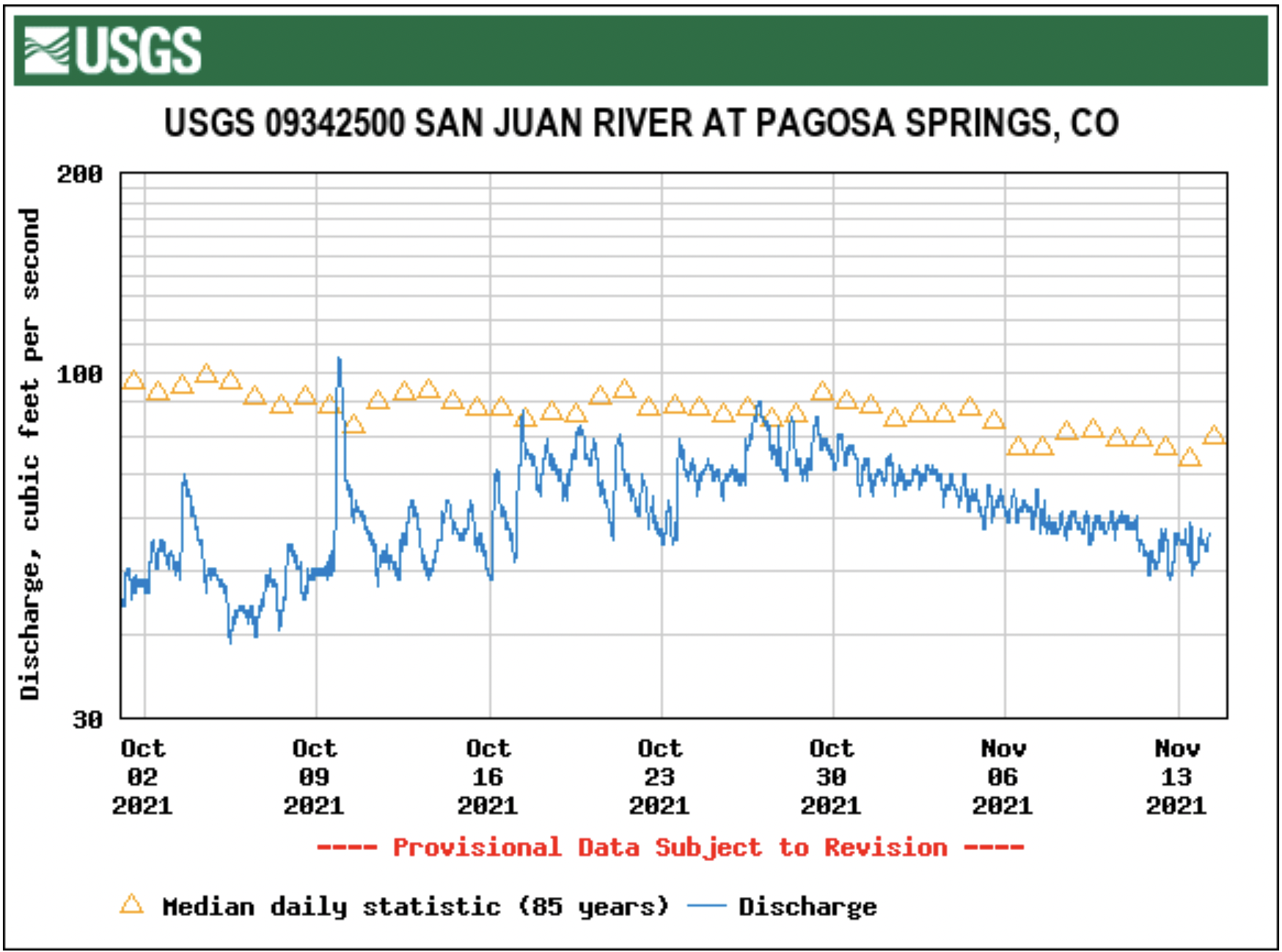
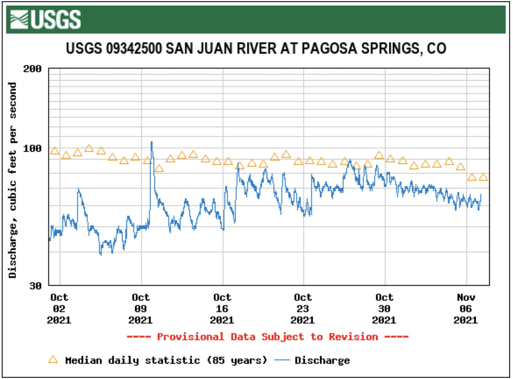
According to the U.S. Geological Survey (USGS), the San Juan River was flowing at a rate of 59.2 cfs in Pagosa Springs as of 1 p.m. Wednesday, Nov. 10.
Based on 86 years of water records at this site, the lowest recorded flow rate for this date is 20 cfs, recorded in 1951.
The highest recorded rate for this date was in 1987 at 348 cfs. The average flow rate for this date is 98 cfs.
As of 1 p.m. Wednesday, Nov. 10, the Piedra River near Arboles was flowing at a rate of 51.4 cfs.
The highest recorded rate for this date was 460 cfs in 1987.
The lowest recorded rate for this date was 50 cfs in 1965.
Based on 59 years of water records at this site, the average flow rate for that date is 122 cfs.
Snow report
Pagosa’s high country received a small dusting this past week, with Wolf Creek Ski Area reporting 2 inches of fresh snowfall Wednesday morning.
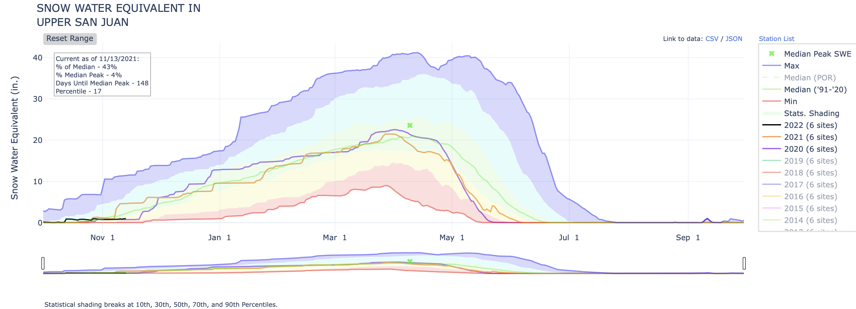
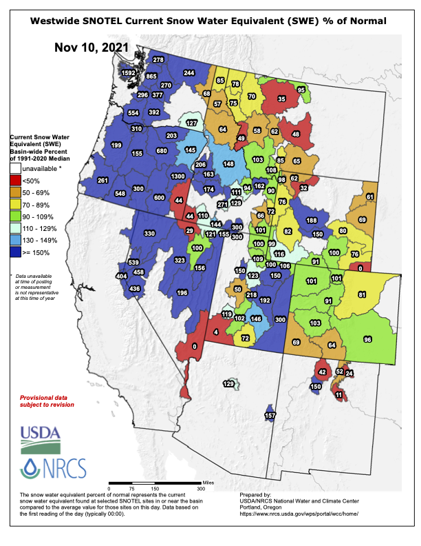
According to the U.S. Department of Agriculture (USDA) National Water and Climate Center’s snow pack report, the Wolf Creek summit, at 11,000 feet of elevation, had 3.5 inches of snow water equivalent as of 1 p.m. on Nov. 10.
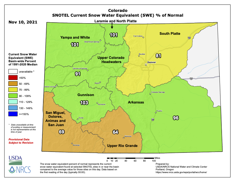
The San Miguel, Dolores, Animas and San Juan River basins were at 69 percent of the Nov. 10 median in terms of snow pack.
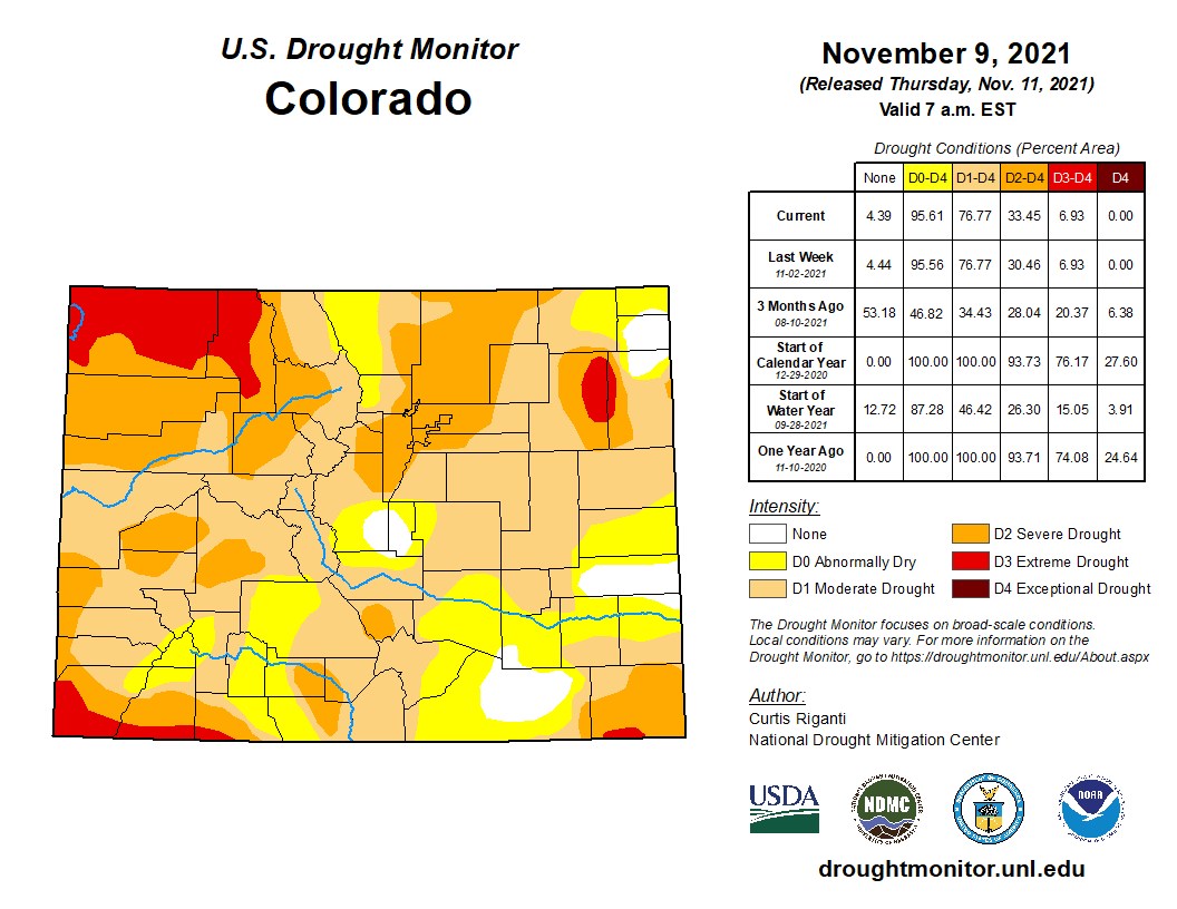
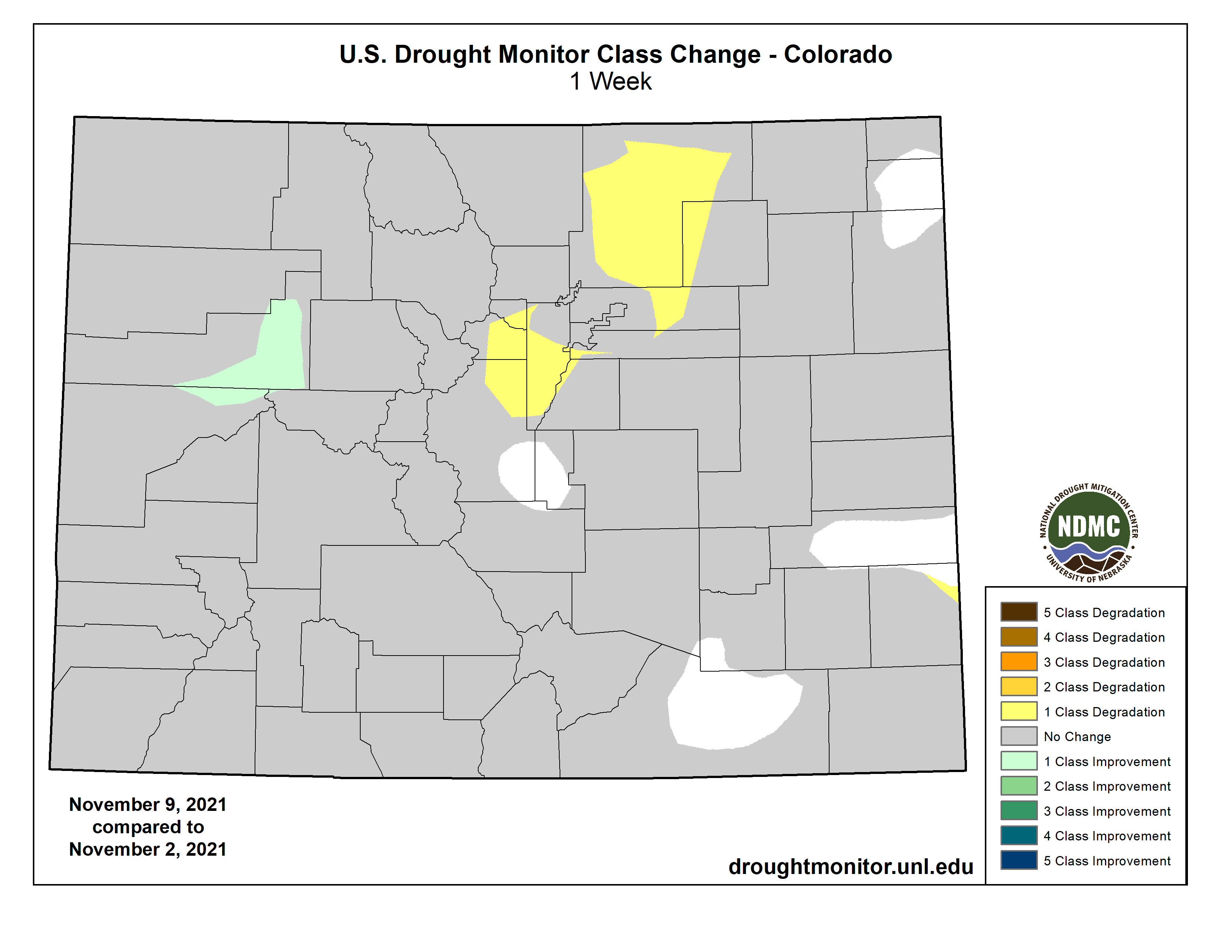
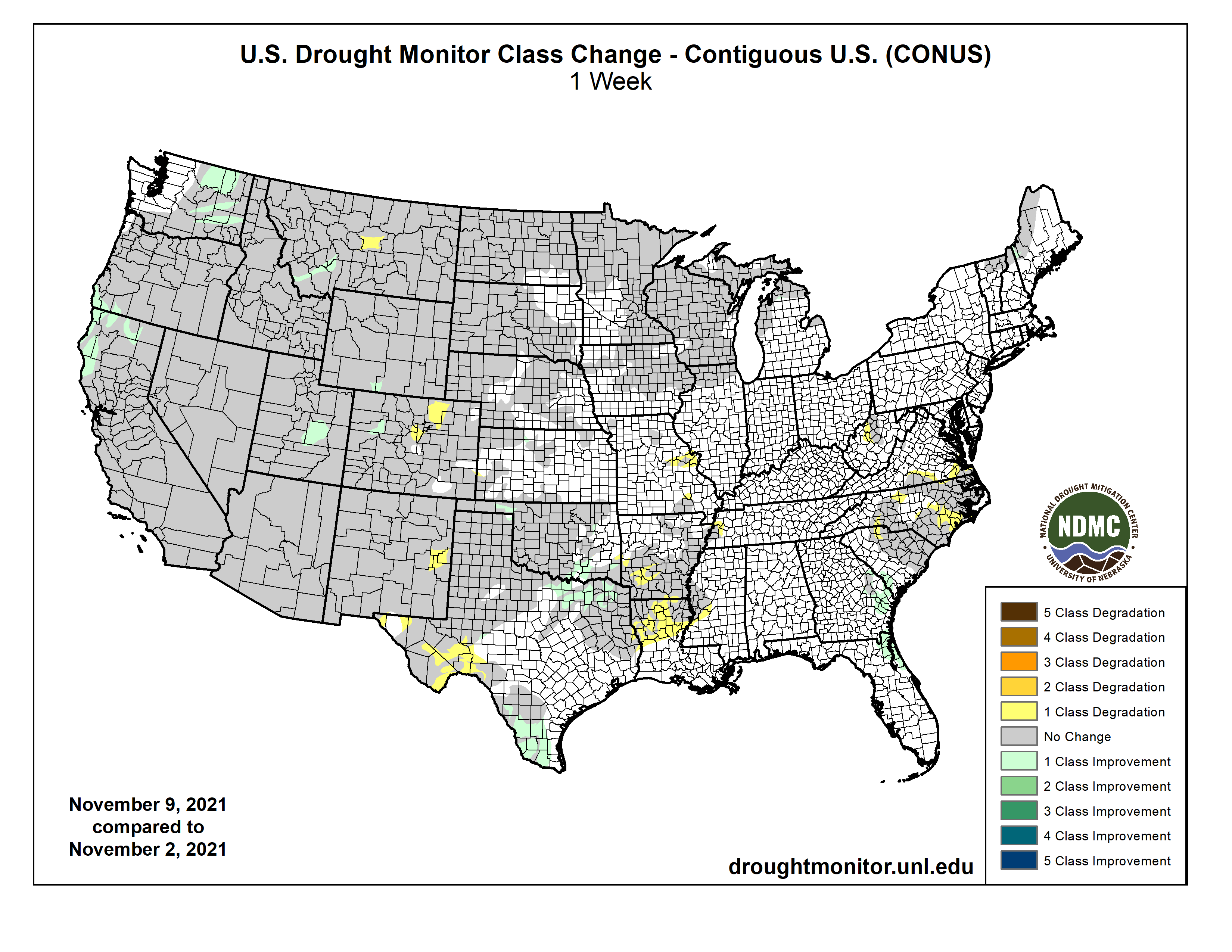
Colorado Drought Monitor map November 9, 2021.
Drought report
The National Integrated Drought Information System (NIDIS) was last updated on Nov. 2.
The NIDIS website indicates 100 percent of Archuleta County is abnormally dry.
The percentage of the county in a moderate drought is listed at 70.86, which is up slightly from the previous report of 70.79 percent.
The NIDIS website also notes that 47.66 percent of the county is in a severe drought stage, consistent with last week’s report.
Additionally, the NIDIS website notes that 10.33 of the county remains in an extreme drought, consistent with last week’s report.
No portion of the county is in an exceptional drought.
Improved agricultural practices and widespread irrigation may stave off another agricultural calamity in the Great Plains. But scientists are now warning that two inescapable realities — rising temperatures and worsening drought — could still spawn a modern-day Dust Bowl.
Growing up in rural Iowa in the 1990s, Isaac Larsen remembers a unique herald of springtime. The snowbanks piled along roads, once white or gray, would turn black. The culprit was windblown dust, stirred from barren farm fields into the air.
Even as some of the region’s farmers have adopted more sustainable practices, the dust still flies. Not long ago, Larsen’s mother told her son about an encounter with a dust storm, saying “the soil was just blowing across the road — almost like a blizzard, but black.”
Larsen, a 42-year-old geoscientist at the University of Massachusetts-Amherst, recently published a paper on soil loss in the U.S. Corn Belt. Since farming began, Larsen and his coauthors estimate that more than one-third of the Corn Belt — nearly 30 million acres — has lost all of its nutrient- and carbon-rich topsoil. Similar processes also are taking place on the neighboring Great Plains, a sprawling region that includes Kansas, Nebraska, and the Dakotas, as well as parts of Texas, Oklahoma, Missouri, Montana, and Colorado.
Each dust storm represents a thin layer of the earth, exfoliated by the atmosphere and relocated. Over time, as countless such storms have swept across the Midwest and Great Plains, they have removed the legacy of thousands of years of plant life and death there. The most striking example was the 1930s Dust Bowl, the environmental and agricultural catastrophe that stripped topsoil from millions of acres across the American interior, plunging farmers into bankruptcy, destroying crops, and fundamentally reshaping the heartland.
Much has changed in the U.S. heartland since the 1930s, with widespread irrigation and — on some farms — improved agricultural practices. But given the rising temperatures and worsening droughts caused by gobal warming, some scientists are asking whether the U.S. breadbasket is headed for another Dust Bowl.
In a 2018 National Climate Assessment, U.S. scientists warned that under current warming scenarios, temperatures in the southern Great Plains could increase by 3.6 to 5.1 degrees F by 2050 and by 4.4 F to 8.4 F by 2100, compared to the 1976-2005 average. The region is projected to be hit by dozens more days with temperatures above 100 degrees F. Temperature increases are likely to be less severe in the northern part of the region, but the entire Great Plains is nevertheless expected to weather both more heatwaves and periods of extreme drought, according to the National Climate Assessment.
The seeds of the Dust Bowl were sown when farmers in the early 20th century tore out millions of acres of hardy native grasses to plant wheat and corn during a relatively wet period. Then, when a historic, multi-year drought and heatwave occurred in the 1930s, the crops died and the exposed topsoil was left dry and loose, ripe to be swept away by strong winds. The ensuing storms could be immense: On April 14, 1935, the “Black Sunday” dust storm lofted central plains topsoil all the way to the cities of the East Coast. By the time the Dust Bowl was over, millions of migrants had fled the once-promising Great Plains for California and other western states.
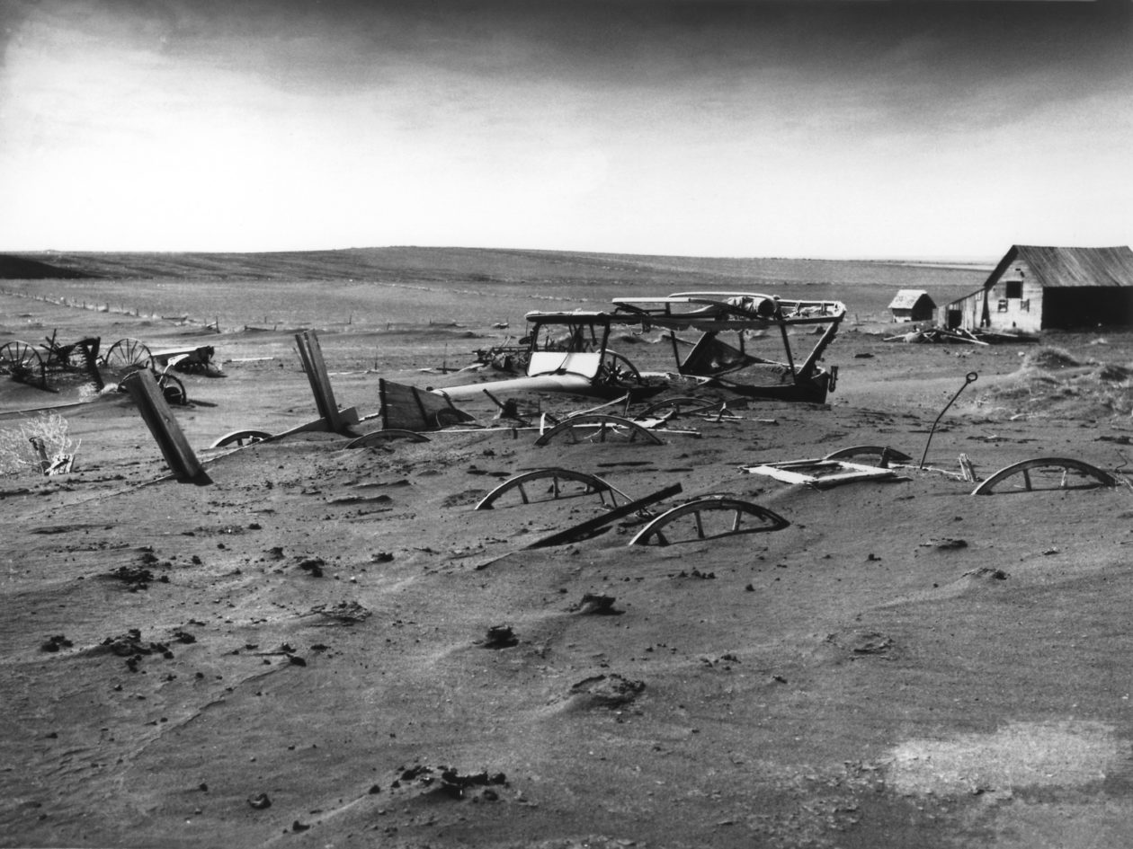
A buried barn lot in South Dakota at the height of the Dust Bowl in 1936. WIKIMEDIA COMMONS
But the catastrophe spurred innovation, too. In the midst of the Dust Bowl, the government acted quickly to establish the Soil Conservation Service, which helped promote more sustainable techniques like no-till agriculture and cover cropping, which reduce the amount of exposed soil. Many of the heartland’s industrial-scale farming operations, however, did not adopt these practices, though in recent years no-till agriculture has become more widespread.
The Ogallala aquifer, also referred to as the High Plains aquifer. Source: National Oceanic and Atmospheric Adminstration
Since the 1940s, many farmers on the Great Plains also have extensively irrigated their crops, allowing them to weather dry periods and further preventing topsoil erosion. But that reliance on irrigation has left the Great Plains open to new dangers. The Ogallala Aquifer — which makes up most of the High Plains Aquifer System and supplies the water for 30 to 46 percent of irrigated land in some Great Plains states — has been steadily overdrawn in recent decades; by some estimates, the Ogallala Aquifer could be 70 percent depleted within 50 years.
“There comes a point where if you’re not replenishing those resources like aquifers, then all you need is the next minor drought to come along, and if you don’t respond, then you run the risk of another Dust Bowl-like event,” says Tim Cowan, a senior research fellow at the University of Southern Queensland who studies the effects of climate change on precipitation and heatwaves.
Heat and drought are intimately linked, meaning that worsening heatwaves mean more droughts and vice versa. That one-two punch has many scientists concerned. “Dry soils have this exacerbating effect,” says Wim Thiery, a climate scientist at the University of Brussels. “There is this positive feedback where dry soils lead to more warmth.”
When the soil contains a lot of moisture, incoming energy from the sun gets absorbed by the water as it turns from a liquid into a gas. But when the soil contains little water, that energy is converted directly into heat. The result is that droughts lead to more severe heatwaves, and those heatwaves in turn lead to drier conditions.
Data shows that both drought and heat are becoming more common — and perhaps increasing the feedback effects between them. In a recent study in Nature, Cowan and his coauthors found that greenhouse gas emissions have made a period of Dust Bowl-like heatwaves more than two-and-a-half times more likely compared to the 1930s.
Ben Cook, a climate scientist at the NASA Goddard Institute for Space Studies, says the same goes for drought. “What we’re seeing in a lot of regions is this kind of amplified evaporation effect that’s making it … easier to get into drought, a little bit harder to get out of drought, and making the droughts themselves a bit more intense than they would have been in a colder world.”
Meanwhile, agriculture continues to thrive in the Midwest and Great Plains. The combined regions are top producers of crops like corn, wheat, and soybeans, as well as livestock. That level of agricultural intensity, paired with increasingly hotter weather, raises the stakes for the United States should another historic drought occur.
One paper in 2016 relied on computer simulations to model the effects of Dust Bowl conditions on modern agriculture. Corn and soy crop yields would decline by around 40 percent, the authors estimate, and wheat yields would drop 30 percent. And every one degree Celsius (1.8 F) increase in temperature would cause the effects to worsen by 25 percent.
In a world where drought and heatwaves become routine, the two might combine to tip the country into a situation where agriculture becomes increasingly threatened, with profound impacts on U.S. food supplies.
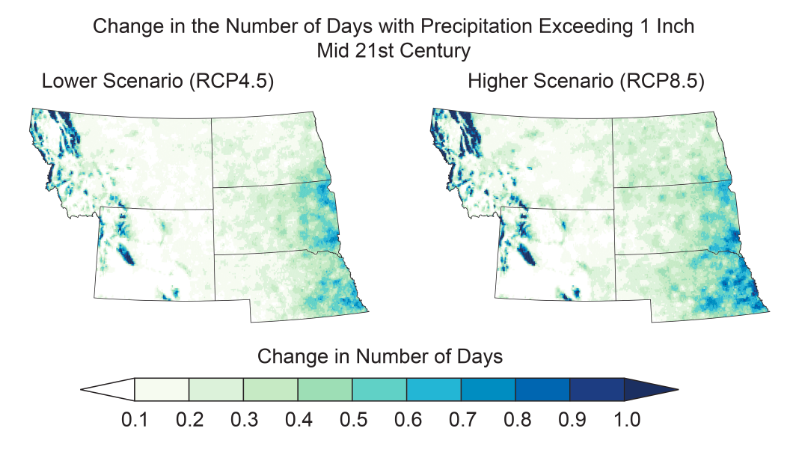
Projected changes are shown for the annual number of very hot days and heavy precipitation events in the mid-21st century. GLOBALCHANGE.GOVProjected changes are shown for the annual number of very hot days and heavy precipitation events in the mid-21st century. GLOBALCHANGE.GOV
The United State got a recent taste of Dust Bowl-like conditions. In 2012, the country experienced one of its worst droughts on record, along with a sizzling heatwave. La Niña conditions in the Pacific Ocean, combined with the lingering effects of a dry 2011, resulted in the driest summer in the U.S. since 1988. By July, nearly two-thirds of the country was in drought conditions, according to the U.S. Drought Monitor. Meanwhile, July 2012 was the second-hottest month on record at the time.
The effects on the nation’s farmers were substantial. Estimates put agricultural losses at around $30 billion, and corn yields declined by 26 percent. But even though the 2012 drought was similar in character to the Dust Bowl, billowing dust storms and wholesale agricultural collapse were absent. Similarly, a severe drought in the 1950s also failed to kick off another Dust Bowl.
“We’ve had bad droughts in the Central Plains since the Dust Bowl, but we haven’t had the same level of land degradation and dust storm activity,” Cook says. “And part of the reason for that is because our land use practices have changed.”
For the time being in the Great Plains, irrigation allows farmers to weather even severe droughts by drawing on water stored in underground aquifers. But the overuse of the High Plains Aquifer System, especially the Ogalalla Aquifer, is taxing the region’s groundwater supplies. Since 1987, the U.S. Geological Survey (USGS) has been gathering yearly data on water levels in the High Plains Aquifer by monitoring thousands of wells.
Though changes vary across the region, the overall picture is one of persistent decline, says Virginia McGuire, a hydrologist with the USGS who’s been monitoring the aquifer for more than two decades. The volume of water in the aquifer in 2015 had fallen by 273.2 million acre-feet since irrigation began in the 1940s, according to a USGS report she authored. A map in the report shows red blotches spread across Texas, Oklahoma, and Colorado, revealing stark declines in the amount of water infusing the soil. Water levels in some places are less than half of what they were a century ago, McGuire says.
“If that trend doesn’t change, at some point there’s going to have to be a reckoning,” she says.
So much irrigation is taking place on the Great Plains and in other global agricultural zones that the added water is actually cooling regional temperatures. In a 2020 paper in Nature Communications, Thiery and his colleagues compared average temperatures in heavily irrigated regions to those in the rest of the world. “We found that irrigation has a pretty pronounced cooling effect,” he says. Regions that were irrigated warmed on average by 0.8 C (1.5 F) less on hot days than the rest of the world, they found. But the cooling effect of large-scale irrigation is ultimately unsustainable.
“We are putting massive pressure on our groundwater resources by irrigating,” Thiery says. “At some point you will reach the point at which there is no more water coming from the wells.”
Water managers and farmers are already making changes to reduce water use, such as irrigating just half of their fields, or using multiple smaller wells to increase water yields from parched groundwater reserves, according to McGuire. But depleted aquifers take a long time to recharge, especially in areas like the southern Plains, where the water table is far below the surface. Meanwhile, dry years continue to stress the aquifer. During the three-year period between 2011 and 2013, the aquifer lost nearly as much water as it did between 1980 and 1995.
In 2012, says Cook, “the system was resilient enough to deal with a single year of really bad drought in the central U.S. Now, if that 2012 drought had lasted three, four, or five years, would our system have been able to handle that? That I don’t know.”
Eastern Colorado farmer Jay Sneller watches the mowing of his drought-ravaged corn crop during the drought of 2012. JOHN MOORE / GETTY IMAGES
A key reason for the resilience of U.S. agriculture is the government’s ability to provide aid to farmers when times are tough, Cook says. But climate change is affecting the entire world, with hotter, drier conditions predicted to increase in regions — such as South Asia and East Africa — that may have little ability to cope with more extreme weather. In the Indian state of Punjab, where more than 80 percent of the land is used for agriculture, water tables are dropping quickly. A 2019 heatwave in India saw temperatures climb above 120 F, while water shortages led to violent clashes.
A European drought has also strained groundwater resources across much of the continent. Data from NASA’s GRACE-FO satellite from June 2020 revealed dangerously dry soils in Germany, Poland, the Czech Republic, Ukraine, and parts of Russia. Similarly, a record-setting drought in Australia from 2017-2019 battered farmers, with extreme heat also sweeping across the country. Even if nations — particularly developing nations — adopt more sustainable irrigation and agricultural practices, a rapidly changing climate means they could still face crop failures that imperil food supplies.
The Dust Bowl is a uniquely American touchstone, a story of hardship and eventual triumph that has come to define both our country’s historical narrative and physical reality. But in a world where climate conditions grow steadily more extreme, that unparalleled disaster could become far more common.
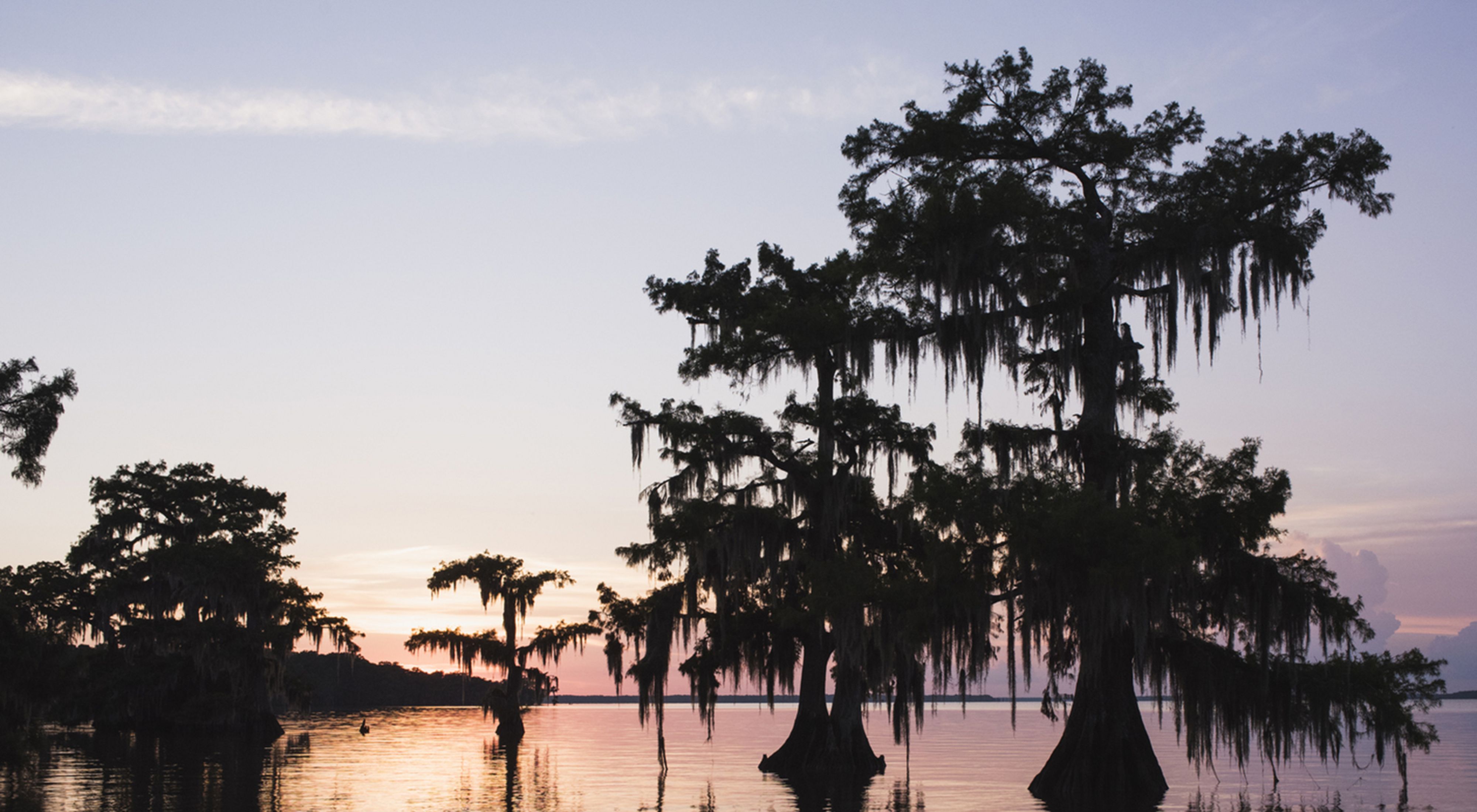
Lousiana Gulf Marsh. Photo credit: The Nature Conservancy
From The Nature Conservancy (Tom Jennings and Ciaran Clayton):
After numerous last-minute delays and attempted derailments, the United Nations Climate Change Conference COP26 finally concluded this afternoon in Glasgow, UK. As COP President Alok Sharma’s gavel fell on the closing session, The Nature Conservancy’s Director of International Climate Policy, John Verdieck, commented:
“Six years ago, the world came together in Paris to declare a shared intent to keep global warming below +2°C, and – if possible – to restrict temperature rise to +1.5°C. The plaudits for this historic agreement were justified at the time – but building that framework was just the start. Despite the various pledges and initiatives revealed in Glasgow, it’s still unclear whether the +1.5°C goal is now within reach.
“At heart, the COP process is a goal-setting mechanism – and in this respect, there’s reason to remain optimistic. Major announcements from multinational coalitions delivered significant promises of methane reduction; actions to reduce or eliminate deforestation; provide critical financial support for the most vulnerable countries; and, perhaps most surprisingly, increased collaboration between the world’s two leading emitters, China and the United States.
“Analysis of these latest commitments by the respected Climate Action Tracker (CAT) and International Energy Agency (IEA) project that the fresh pledges made over the past fortnight have the potential to reduce global warming by 0.5°C – a significant stride toward the +1.5°C target.
“The Glasgow Climate Pact represents the first time the world has formally agreed that tackling fossil fuel subsidies is a goal worth pursuing, and that the +1.5°C goal should be a Northstar for the global community moving forward. These philosophical shifts also represent is a major step towards driving the decarbonization of global economies and accelerating the clean energy transition.
“Perhaps the best news out of Glasgow was the focus and attention paid to the role that nature – and the rights of Indigenous communities whose lands play host to so much of the world’s remaining wildlife habitat – can play in addressing the interconnected climate and biodiversity emergencies. Nature was on the agenda at COP26 like never before. Unlocking the potential of forests, farms, and wetlands to deliver up to a third of the emissions reductions needed by 2030 must be prioritized.
“So, despite suggestions to the contrary, I believe we can leave COP26 with some hope still intact. Major economies like China, the E.U, and the U.S. are beginning to show serious climate ambition and – crucially – the finance to back it up. But still too few have turned ambitious rhetoric into tangible actions. It is imperative, as we look towards COP27 in Egypt and the threats facing its African neighbors, that on-the-ground implementation of proven climate strategies accelerates this year. As UN Secretary-General Antonio Guterres put it, we have now reached “code red for humanity.” There is no more time to waste.
“For all the celebrations at the time, in policy circles we understood that the Paris Agreement only ever provided a scaffolding of sorts – a frame around which to build a safer, more prosperous and lower-carbon planet for our children and our grandchildren. Progress on laying the foundations for the future has been made. Now, the hard work toward accelerating commitments into real-world action must begin.”
La Niña conditions reign in the tropical Pacific, with about a 90% chance of remaining through the winter. Get your popcorn and settle down on the couch—it’s time for this month’s ENSO cinema.
Romantic comedy
A recurring theme here at the ENSO Blog is the on-again, off-again relationship between the tropical Pacific Ocean and atmosphere. ENSO (short for El Niño-Southern Oscillation, the entire El Niño–La Niña system) relies on the interaction between the ocean and the atmosphere. Average conditions in the tropical Pacific (see the drawing below) consist of relatively warmer surface water in the west and relatively cooler surface in the east. Air rises over the warm western water, forming clouds and rain; winds blow west-to-east high up in the atmosphere; air descends over the cooler east; winds blow east-to-west near the surface. Dun-dun-dunnn… it’s the Walker circulation!
ENSO-Neutral or average conditions across the tropical Pacific Ocean. Climate.gov schematic by Emily Eng and inspired by NOAA PMEL.
When La Niña is present, the atmosphere takes one look at that characteristic cooler-than-average central/eastern Pacific ocean surface and gets all amped up. I haven’t yet seen the Walker circulation standing outside La Niña’s house holding a boombox aloft, but ENSO is always full of surprises.
La Niña feedbacks between the ocean and atmosphere. Climate.gov schematic by Emily Eng and inspired by NOAA PMEL.
The resulting stronger near-surface winds (the trade winds) reinforce the cooler ocean surface—the feedback mechanism fundamental to ENSO. For more on how this works, and a delectable bread analogy, check out Michelle’s Oscar-winning post.
All this is to say that La Niña conditions, after developing in September, continued in October. The surface of the ocean in the Niño-3.4 region, our primary ENSO-monitoring region, was about 1.0˚ C (1.8˚ F) cooler than the long-term average, via the ERSSTv5, our primary ENSO-monitoring dataset.
This graph shows monthly sea surface temperature anomalies (difference from average) in the Niño 3.4 region of the tropical Pacific for 2020-21 (purple line) and all other years (gray lines) starting from first-year La Niña winters since 1950. While two La Niña winters in a row is pretty common, three-peats have occurred only twice. Climate.gov graph based on ERSSTv5 temperature data.
October featured La Niña’s atmospheric conditions—more rain than average over Indonesia, less over the central Pacific, and stronger-than-average trade winds over portions of the equatorial Pacific. As in all relationships, there are ups and downs, and these patterns were a bit weaker in October than September. However, these two crazy kids are working on their relationship already, with a batch of stronger trade winds currently taking over much of the tropical Pacific.
Action-adventure
“Predictable” isn’t high praise for a movie plot, but certainly is when it comes to the weather and climate. La Niña-related changes to global atmospheric circulation, including its effect on the jet stream, give us a picture of the average weather conditions expected over the next several months. To be clear, we mean the overall average, not that every day will exhibit the same weather!
There have been 23 La Niña events (24 counting this one!) in our historical record, which goes back to 1948. If we look at the October–December rainfall patterns during those La Niñas, we find more rain than average in northern California and the Pacific Northwest, and less than average through the Gulf coast and Southeast.
Composite of October–December precipitation during the 23 La Niña years since 1950, compared to the 1950–2020 average. Composites for other seasons and temperature are available here. Climate.gov image from CPC data.
While La Niña tends to be linked to dry conditions and drought through California and the Southwest, that pattern usually develops in December–February through the early spring. You can step through the seasons to see ENSO impacts here. The strong atmospheric river that brought so much rain and snow to northern California last month was not atypical for a La Niña autumn. Overall, the October and early November North American rainfall map looked a lot like what we might expect this time of year during La Niña.
Documentary feature
Spoiler alert! There’s about a 50% chance that La Niña will last into spring 2022 (March–May).
Climate model forecasts for the Niño3.4 temperature anomalies in late 2021 and 2022 . Average dynamical model data (black line) from the North American Multi-Model Ensemble (NMME): darker gray envelope shows the range of 68% of all model forecasts; lighter gray shows the range of 95% of all model forecasts. Most of the plume—that is, most of the model runs—stay beneath the La Niña threshold this winter. NOAA Climate.gov image from University of Miami data.
Will this La Niña, already a sequel itself, end up part of a trilogy? Three La Niña winters in a row isn’t unprecedented—that happened in 1973–1976, and 1998–2001—but it is relatively unusual. We will have a better idea by the late spring about what may happen with ENSO in 2022–2023.
Getting back to our current event, there’s about a 2-in-3 chance that this La Niña will be at least moderate in strength, meaning the peak Oceanic Niño Index (the 3-month-average Niño-3.4 anomaly) will be greater than 1.0°C cooler than average. The stronger the ENSO event, the more predictable the weather and climate impacts. More info about how we forecast the strength of an El Niño or La Niña event here.
Post-credits scene
Regardless of the critical reception, ENSO will always be bringing the drama, and your trusty ENSO bloggers will be here to watch and report!
I’ve always lived in Denver except for a brief stint in Missoula. You would hear about someone’s sibling, who maybe just graduated from high school, packing up their car and moving to the mountains, to be a ski bum. I felt jealous of course but also reverence.
Cameron Walker lived the mountain life for a time and has published this review of Heather Hansman’s Powder Days from that insider point of view. It seems that Ms. Hansman moves readers by writing about what she knows.
This week, I was reading a story from a few years ago about what the last snow on earth might look like. Snow algae, which occur naturally in the snowpack, rise to the surface during the spring; when they emerge, they turn red. This “watermelon snow,” these days, could be seen as a warning. The algae’s presence means the snowpack absorbs more sunlight and melts even faster, allowing even more algae to grow, melting more snow–another of the many tributaries flooding into the rushing feedback loop of climate change.
I’ve been thinking a lot about the future of snow, too, while reading Heather Hansman’s Powder Days: Ski Bums, Ski Towns, and the Future of Chasing Snow. The organisms she’s looking at are much bigger, multicellular creatures, yet they live for snow in their own, human way. And in the ecosystems we’ve developed around ski towns, there’s a different feedback loop of low wages, unaffordable housing, class and race issues, and mental health challenges, all against the same backdrop of the rising global temperatures.
There’s also joy. That’s why I picked up this book in the first place—I spent several years in one of these mountain towns, trying to find my way both on the snow and off of it. Even back then, the tension between bliss and tragedy there could make your throat ache. The feeling of floating down an open bowl with only granite peaks and Jeffrey pines looking on. The accidents and avalanches every winter. The connectedness of being part of an unseen river of localism that runs on friendships and favor, on two-dollar Tuesdays and leftovers from your boyfriend’s restaurant job. The constant scramble for a paycheck and a place to live, the relentless waves of tourists, the aggressive hum that takes over the lift lines on a powder day, the unsettling nature of a world that depends on how much snow will fall. And the interior tensions, too. the idea that you’re here, in this most beautiful place, doing what you love–yet somehow, you’re letting it all slip through your fingers with all of this thinking about it, while everyone around you seems to know how to live like this.
And that was then. Now, these problems have grown, and grown more entangled. Hansman, a former editor at Powder and Skiing magazines and former ski bum, set off to find out—is this life even possible anymore?
To find out, she went to the mountains—both to ski with those who’ve managed to make skiing their lives and to look at how history, economics, racism, sexism, and the climate are shaping the mountains and the people who live there today.
She doesn’t come away with easy answers. In considering the vanishing snow while skiing in Santa Fe, she writes about solstalgia,”the name for the feeling of the world changing around you, when you were told it would be stable.” Hansman feels it almost constantly now, as the places where she would go to reconnect with the land grow drier each year.
In many ways, the life of a ski town is a rarefied one, and it’s clear from Hansman’s reporting that this life is becoming more and more segregated between the haves and the have-nots, while also maintaining barriers against non-whites and other, subtler barriers against women and anyone who doesn’t quite fit a certain image of the outdoors, including those whose mental health has been affected by mountain tragedies. But it’s also a miniature burden of the problems we face in the flatlands and at every elevation in this country. Throughout the book, she holds up these places to the kaleidoscope, looking at each of these problematic fragments.
Still, woven within all these challenges is the clear wonder of the mountains. While the book offers no clear solutions, this connection seems to be what gives Hansman hope: that somehow, channeling the best parts of a skiing life—the freedom, the outdoors, and the bonds skiing can create with others and with the land—can somehow shift us toward new ways of thinking. This might mean that the life of a ski bum might not look exactly like what it used to. But the snow–the pale pink of watermelons, the rusty shade of old blood–doesn’t look like it used to, either.
A Colorado taxpayer group has filed a class action lawsuit in the 13th Judicial District Court in Logan County to try to overturn a mill levy increase by the Lower South Platte Water Conservancy District.
The Public Trust Institute, a Colorado-based public interest law firm, and the National Taxpayers Union Foundation of Washington, D.C., filed the lawsuit Wednesday on behalf of an ad hoc group of taxpayers in Logan, Morgan, Sedgwick and Washington counties. Jim Aranci of Crook, Charles Miller, Jack Darnell and William Lauck of Morgan County and Curtis Werner of Merino are listed as plaintiffs in the lawsuit. Besides the water district, the defendants include the county clerks of the four counties, who collected the taxes and handed the funds over to the district.
At issue is the interpretation of a 1996 ballot question in which the LSPWCD “de-Bruced,” or excused itself, as the result of a public vote, from provisions of the TABOR amendment. In that ballot question, the district stated it would seek a public vote in order to raise taxes.
But other wording in that ballot question, and the district’s original mill levy allowance when it was formed in 1964, are at the crux of the conflict. When it was formed, the water conservancy district was allowed by state statute to levy up to 1 mill on property within the district, which includes parts or all of the four counties. The district’s board of directors had previously only asked for 0.5 mill because that was all that was needed.
At the end of 2019, however, the district’s board decided to raise the levy to the statutorily allowed 1 mill for 2020 to, among other things, help fund preparatory work on a project that eventually will help supply both the district and the City of Parker extra water from the lower reaches of the South Platte River. That mill levy was certified by county commissioners in the four counties at that time, and the district began collecting the tax revenues in 2020.
As the district board was planning its 2021 budget in December of 2020, however, a group of taxpayers objected, pointing to the 1996 ballot measure’s final sentence. It reads, “No local tax rate or property mill levy shall be increased at any time, nor shall any new tax be imposed without the prior approval of the voters of the LSPWCD.”
Jim Aranci, a former chairman of the district’s board, said Wednesday that the wording of that 1996 de-Brucing question was quite clear…
Joe Frank, general manager of the conservancy district, said Friday he’d heard rumors of a lawsuit being filed, but was not at liberty to discuss the issue further. He did, however, reaffirm the board’s position that the increase was thoroughly researched in 2019 before it was instituted for the 2020 budget year. He said the district’s legal counsel pointed to other wording in the de-Brucing ballot question: That the district could “utilize the full proceeds and revenues received from every source whatever, without limit.” And those “full proceeds and revenues” included the remaining half-mill originally allowed by statute but never used. In other words, the public vote would only be needed if the district wanted to exceed its original allowance of 1 mill.
Frank reiterated Friday that the board did not take the step lightly, and spent a lot of resources getting the right answers to its questions…
The water district has still been allowed to collect its 1 mill levy, since it was certified for the 2020 budget year. According to Colorado Revised Statute 39-1-111 (3) “If the board of county commissioners … fails to certify such levies to the assessor, it is the duty of the assessor, upon direction of the division of local government, to extend the levies of the previous year …”
The climate “hockey stick” refers to a reconstruction of temperatures over the past 1,000 years. The data shows flattish temperatures over the last millennium, like the handle of a Hockey stick, ending in a “blade” of rapidly rising temperatures since the industrial revolution. The idea first appeared in a paper by Michael Mann and Raymond Bradley of the University of Massachusetts and Malcolm Hughes of the University of Arizona. The work became famous after appearing in a UN climate report, after which it was the focus of climate denial, hacking, defamation, and disinformation, all of which was dramatized in a recent BBC TV drama called “The Trick.”
Today, in a paper published by Nature, scientists show that the “handle” of the “hockey stick” extends back 9,500 years, while its “blade” is taller—the last decade was 1.5° C hotter than the average temperature over the last 11,700 years. “Human-caused global temperature change during the last century was likely faster than any changes during the last 24,000 years,” said lead author Dr. Matt Osman of the University of Arizona.
An animation showing the warming that ended the last ice age. Credit: ARS Technica
Taking the temperature of times before thermometers
To measure temperatures at times long before the invention of thermometers, scientists must use indirect proxies. For the new study, scientists carefully vetted over 500 proxy records from oceans around the world; the data shows the fossilized remains of plankton and microbes in sediments where the age is known from radiocarbon dating.
Researchers then used statistical methods to calculate sea surface temperatures from the chemical properties of those remains. “We spent seven years developing the models for the different kinds of marine temperature proxies, incorporating knowledge from biology and geochemistry and using the best statistical practice,” explained coauthor Dr. Jessica Tierney of the University of Arizona and leader of the lab in which this research was conducted.
The researchers combined the proxy temperatures with climate model simulations to account for the incomplete geographic distribution of data, and they cross-checked their results with independent records such as ice drilled from polar regions and stalagmites in caves.
Resolving a conundrum
The researchers’ work allowed them to produce maps and graphs of global temperatures as Earth emerged from the last ice age, providing 200-year time slices going back 24,000 years.
The authors find that the ice age was 7° C colder than the preindustrial era, about a degree colder than an earlier estimate had shown. Warming began 16,900 years ago, and by 11,000 years ago, Earth was enjoying a relatively warm “interglacial” climate. These findings refine the details but match the broad outline revealed in earlier work.
Resolving the Holocene Climate Conundrum: Proxies aren’t evenly distributed around the planet, so a simple average shows Holocene cooling (red). The new work by Osman and colleagues corrects for geographic unevenness, and the result is a slight warming trend (blue).
But unlike earlier studies, the new work shows that, prior to our current warming, there was a slow, long-term warming of 0.5° C that started 9,500 years ago. It also shows that the “handle” of the climate “hockey stick” is straight, whereas in prior studies, the “handle” was warped, with early warming followed by cooling into preindustrial times.
The new results resolve a disagreement between climate models (which simulated warming) and proxy studies (which showed cooling). The problem was known as the “Holocene Temperature Conundrum.”
Dr. Samantha Bova of San Diego State University, who published a reconstruction of temperatures for the same time period earlier this year, agreed, saying, “Both reconstructions show no evidence for an early Holocene warm period.” She pointed out that her paper used a completely different method, so the fact that her research came to the same conclusion as the Tierney team “leaves little room for doubt that the Holocene was a period of long-term warming,” she said.
So what changed?
Osman and colleagues concluded that most of the conundrum’s resolution is due to the sophisticated handling of geographic unevenness in their data compared to prior work. “Older reconstructions are just binned latitudinal averages,” said Tierney. “[That] method has a downside in that it doesn’t account for temperature changes in regions that are unsampled.”
Tierney’s team also found the conundrum could not be explained by seasonal growth of the plankton and algae used to reconstruct temperatures. “Even after accounting for seasonal bias, we still could not reconcile the [results] with reconstructions based on proxies alone,” said Tierney. “This led us to conclude that spatial representation was the most important factor.”
We already have a hockey stick, but future warming will only make the contrast with the rest of the post-glacial period more extreme.
Dr. Shaun Marcott of the University of Wisconsin-Madison, who led a proxy reconstruction of Holocene climate in 2013, told Ars that the new work is a significant step forward. “The full field surface temperature reanalysis… is well beyond prior papers and has taken this team of scientists close to a decade to build,” he said, adding, “It is a triumph, and what this group has been doing is spectacular!”
For Mann, who had to go all the way to the US Supreme Court to defend his work and reputation, this work represents yet another vindication. “It’s become clear that the hockey stick ‘handle’ is much longer, and the ‘blade’ is sharper as we’ve warmed substantially since 1998 when we first published the ‘Hockey Stick,’” he told Ars.
Howard Lee is a freelance science writer focusing on geology and climate change in deep time. He holds a B.Sc. in Geology and M.Sc. in Remote Sensing, both from the University of London, UK. When not writing, he’s probably gardening, hiking, or kayaking near his home in rural Massachusetts.
States in the lower Colorado River basin are developing a $100 million plan that will leave more water in Lake Mead over the next couple of years.
The goal is to keep the lake from hitting a critical level that would leave the reservoir more vulnerable to rapid decline.
“You don’t have much of a buffer left to deal with that (rapidly declining water level) if you have a bad year of runoff in the system,” said Tom Buschatzke, director of the Arizona Department of Water Resources.
The negotiations between Nevada, Arizona, California and the U.S. Bureau of Reclamation for additional reductions in water use come just months after the federal government declared Lake Mead’s first water shortage. That declaration forces Nevada and Arizona to take cuts to their allocation of water next year.
The water level projections that led to those cuts also triggered a provision in a 2019 drought response agreement that forces the lower basin states to discuss ways to prevent the lake from falling below an elevation of 1,020 feet, Buschatzke said.
As of Thursday, the water level was just below 1,066 feet…
The states have not finalized how they will reach the 500,000 acre-foot goal for the next two years, but Buschatzke said the preference is voluntary conservation over forced cuts.
He said the effort is going to cost about $100 million, with his department committing $40 million. Next week, the Southern Nevada Water Authority board is scheduled to consider approving the use of $20 million over the next two years to continue fighting lake level decline.
One way to meet the conservation goal is to pad reserves and keep them in the lake through 2026. The states are also looking at leaving reserves in the lake that were scheduled to be released next year.
Buschatzke said the federal government could also look at making delivery of water to the lower basin more efficient.
Another path is new system conservation, a process of making water use more efficient and using the saved water to bolster Lake Mead’s elevation. A portion of Southern Nevada’s spending may go toward this, a spokesman said…
Buschatzke said the goal is to finalize the two-year agreement next month, then get to work on filling out the remaining three years of the plan.
Brad Udall: Here’s the latest version of my 4-Panel plot thru Water Year (Oct-Sep) of 2021 of the Colorado River big reservoirs, natural flows, precipitation, and temperature. Data (PRISM) goes back or 1906 (or 1935 for reservoirs.) This updates previous work with @GreatLakesPeck.
Click on a thumbnail graphic to view a gallery of drought data from the US Drought Monitor.
US Drought Monitor map November 9, 2021.
High Plains Drought Monitor map November 9, 2021.
West Drought Monitor map November 9, 2021.
Colorado Drought Monitor map November 9, 2021.
Click here to go to the US Drought Monitor website. Here’s an excerpt:
This Week’s Drought Summary
Over the last week, multiple storm systems moved into the Pacific Coast, resulting in mostly beneficial precipitation in western portions of Washington, Oregon, and northern California. Some of these areas saw improvements to ongoing drought conditions as a result of these precipitation events. A few other spots in the West, primarily north and east of the Great Basin, saw some precipitation, but conditions in other parts of the West were largely dry. Outside of the Pacific Coast states, only a few changes were made to the Drought Monitor this week in the West. For more detail on these changes, please see the West region paragraph below. Elsewhere in the contiguous United States, widespread rain, amounting to between half an inch and 2 inches, fell in the Southern Great Plains, primarily along and to the east of Interstate 35. As a result, some areas along the Texas/Oklahoma border and parts of south Texas saw improvements to drought conditions. Farther east, heavy rainfall struck parts of Florida and the southeast U.S. coastline, resulting in some improvements to dryness in Florida, Georgia, and southern South Carolina. In drier parts of North Carolina and adjacent South Carolina, drought conditions remained the same or worsened. While not enough to improve ongoing dryness and drought in the Michigan UP, lake effect snow staved off any worsening of drought. Along the Pacific Coast, temperatures were generally within a few degrees of normal this week. Farther east, roughly northwest of a line from the Great Lakes to El Paso, temperatures were well above normal. Parts of the Dakotas saw temperatures 6 to 10 degrees warmer than normal. Southeast of that line, temperatures were mostly cooler than normal, with parts of Arkansas, Louisiana, and Texas falling 6 to 10 degrees below normal…
Primarily dry weather occurred in the High Plains region this week. In western South Dakota, precipitation amounts up to an inch fell, and more minor precipitation amounts occurred in south-central Kansas. A couple minor improvements to conditions occurred in western Kansas. Well above normal temperatures returned this week in the Dakotas, where temperatures from 6 to 10 degrees above normal occurred. In the Dakotas, where long-term drought is still ongoing, livestock water quality and fawn production were both reported to be suffering as a result of the drought…
Colorado Drought Monitor one week change map week ending November 9, 2021.
Along the Pacific Coast, near or slightly below normal temperatures combined with heavy precipitation (which exceeded 5 inches in some areas) to improve drought conditions in parts of northern California, southwest Oregon, and Washington. In central Utah, groundwater conditions and long-term precipitation deficits had improved enough for some of the exceptional drought to improve to extreme drought. In Montana, much of the eastern part of the state remained dry, leading to some expansion in exceptional drought, where multiple short- and long-term datasets indicate worsening conditions. In western Montana, a small part of exceptional drought improved to extreme drought where short- and long-term precipitation deficits had improved. In small parts of western Colorado and south-central Wyoming, streamflow and precipitation deficits had decreased enough to lead to improving drought conditions. Farther east in Colorado, recent warm temperatures combined with dry weather to lead to worsening drought conditions in a few areas. Finally, moderate drought expanded in eastern New Mexico, where short-term dry weather combined with depleted soil moisture to lead to worsening conditions. In Oregon and California, long-term drought conditions have adversely affected salmon populations and migratory birds. Due to widespread recent precipitation, much of the West region is now experiencing long-term drought, rather than both short- and long-term drought…
In eastern Texas and Oklahoma, and in far northwest Louisiana and western Arkansas, widespread rain over a half inch fell this week. As a result, many areas from the Dallas-Fort Worth Metroplex and eastward along the Red River saw improvements to ongoing drought and dryness. Improvements also occurred in south Texas. In parts of southwest Texas that did not see rain, some worsening of drought conditions occurred, due to increasing precipitation deficits and lessening soil moisture. Conditions also worsened in parts of northern Louisiana and southern Arkansas where short-term precipitation deficits increased. Most of the region saw cooler than normal temperatures this week, with widespread readings between 6 and 10 degrees below normal in east Texas, Louisiana, and Arkansas. The western reaches of the South region saw near- or above-normal temperatures…
Looking Ahead
The Weather Prediction Center’s forecast (valid November 10 – 16) calls for multiple rounds of precipitation in the Pacific Northwest. These events are expected to bring heavy rain with local areas of flash flooding. Snow is expected over the high elevations of the Pacific Northwest to the Upper Midwest. A cold front sweeping across the eastern half of the country will bring showers and thunderstorms to the South and rain and rain to much of the East. As the front moves through, temperatures will drop 2 – 5 degrees below normal in the central part of the country and 4 – 9 degrees cooler than normal across the Lower Midwest and Southeast. Temperatures will be 5 – 11 degrees warmer than normal across the West.
The Climate Prediction Center’s 6 – 10-day outlook (valid November 16– 19) favors an active storm track across the northern tier of the Lower 48. This pattern would bring above-normal rainfall to the Pacific Northwest eastward to the Upper Midwest. Below-normal precipitation is likely across the southern tier of the Lower 48, with the greatest odds (more than 50%) over parts of the Southwest, the Southeast, and Alaska. The highest odds for above-normal temperatures occur in the Southwest (greater than 70%). Odds of above-normal temperatures decrease moving northward. The highest odds for below-normal temperatures occur in the Southeast (greater than 60%). Odds of below-normal temperatures decrease across the South and Midwest.
US Drought Monitor one week change map ending November 9, 2021.
Colorado River “Beginnings”. Photo: Brent Gardner-Smith/Aspen Journalism
“We can’t ignore that science any longer” — John Fleck
“If you don’t understand the nature of the problem you’re going to come up with a solution that’s less than adequate” — Brad Udall
From PBS: “The Colorado River runs nearly fifteen hundred miles, winding through seven states and Mexico. It supplies drinking water to nearly 40 million people, irrigates nearly 4 million acres of farmland and attracts millions of nature lovers to scenic Grand Canyon vistas. And it is on the brink. A 20 year mega-drought — exacerbated by climate change — is squeezing the Colorado dry. It’s a crisis for the people of the Southwest and a “canary in the coal mine” for us all.”
Brad Udall: Here’s the latest version of my 4-Panel plot thru Water Year (Oct-Sep) of 2021 of the Colorado River big reservoirs, natural flows, precipitation, and temperature. Data (PRISM) goes back or 1906 (or 1935 for reservoirs.) This updates previous work with @GreatLakesPeck.The river is flowing [May 2021]! Observers have not yet confirmed that the freshwater has met the sea, but they think it may with the next high tide. Photo: Jennifer Pitt/Audubon
Colorado snowpack basin-filled map November 10, 2021.Westwide SNOTEL basin-filled map November 10, 2021.
The NRCS is not updating the old Basin High/Low graphs that I’ve posted for years very often and I’m told those graphs will be retired soon. If you are interested you can use their interactive maps from this link:
At Chatfield Farms, our CSA team is committed to investing in regenerative systems. Amidst mounting threats such as climate and environmental change that cause erratic farming conditions, we seek to learn about and practice regenerative principals so that we can continue to provide food to our communities.
In 2021 we were able to make great strides toward our regenerative goals. We developed an onsite composting program and practiced diligent cover cropping to protect and build our soils. We took steps to build high tunnels and windrows to protect crops from weather events and build resiliency into our operation. We are transitioning to reusable fabrics and irrigation options, rather than disposable. We continued to practice minimal tillage in many parts of the farm and have invested in equipment to expand those practices.
Through these efforts, our farm was able to provide tens of thousands of pounds of produce to many individuals and families in the greater Denver area.
This time of year, like many vegetable farmers in the region, we transition from the fast-paced hustle of the spring and summer to the reviewing, researching and planning nature of the colder months. As we re-visit the idea of regenerative agriculture this season, I find myself proud of all we have accomplished, and re-centering on a goal of mine.
This goal is to cultivate a more “kincentric” view of the world, to un- and re-learn the ways in which I understand my connection to the rest of the natural world. A kincentric view is one where we humans see ourselves as kin with the Earth and everything in it rather than as separate entities. This idea has indigenous roots and suggests a relationship of mutual respect among living things, stressing the importance of balancing give and take, input and extraction. For me, this seems as central to a regenerative practice as minimal tillage or cover cropping.
I believe it is our responsibility as farmers to observe changes in and interactions between the various facets of our ecosystem, and work to create a balance between our goal of food production and the needs of the organisms within the system.
Tractor at Chatfield Farms. Photo credit: Denver Botanic Gardens
La Niña intensifies the average atmospheric circulation—surface and high-altitude winds, rainfall, pressure patterns—in the tropical Pacific. Over the contiguous United States, the average location of the jet stream shifts northward. The southern tier of the country is often drier and warmer than average. NOAA Climate.gov illustration.
Most years by Nov. 9, Puebloans would have already experienced their first snowfall and retired their lighter jackets for heavy winter coats.
That’s not the case this year.
“The weather patterns have just been really unfavorable for any sort of snow here in Pueblo so far this year,” said Cameron Simco, a meteorologist with the National Weather Service in Pueblo. “It’s just been kind of warm and the systems that come through are really fast and don’t give us a lot of time to get snow here.”
With temperatures in Pueblo reaching 80 degrees over the weekend of Nov. 6-7, the city came just a few degrees short of setting new record high temperatures for those dates.
Meanwhile, Colorado Springs and Alamosa were both hot enough over the weekend to set new record highs, according to the NWS.
What this means for Pueblo’s winter ultimately comes down to the larger climate patterns moving through the atmosphere.
“I know we’re forecasted from our climate partners to have a La Niña, which gives Pueblo generally a drier, warmer winter,” Simco said.
Colorado will benefit from billions of dollars in climate change and water projects in the $1.2 trillion infrastructure investment bill passed by the U.S. House late Friday, conservation groups said over the weekend, with some of the money shoring up drought-stretched obligations to the Colorado River Compact.
More than $8.3 billion in water projects alone earmarked for Western states will help pay for programs such as renting water from farmers to send down the Colorado River in extremely dry years, replanting and managing high country forests devastated by wildfires and recycling more water in cities, said Alexander Funk, director of water resources for the Theodore Roosevelt Conservation Partnership…
Water for Colorado, a broader coalition that Funk speaks for, called the bill’s final approval “a rare opportunity for Colorado to have funding flowing while our rivers are not. Colorado needs to be ready to use as much of these once-in-a-generation federal funds as quickly as possible to address the state’s water resource funding gaps through implementation of the Colorado Water Plan.”
The coalition’s members include Trout Unlimited, Environmental Defense Fund, American Rivers and others.
Pew Charitable Trusts highlighted $1.4 billion of approved spending that will go to states, local governments and tribal governments for repairing and removing culverts, improving fish habitat, and removing barriers to fish spawning and survival, such as dams. The bill also includes $275 million in dedicated funding for the first time to fix roads and make other improvements at national parks and other public and tribal lands…
Brad Udall: Here’s the latest version of my 4-Panel plot thru Water Year (Oct-Sep) of 2021 of the Colorado River big reservoirs, natural flows, precipitation, and temperature. Data (PRISM) goes back or 1906 (or 1935 for reservoirs.) This updates previous work with @GreatLakesPeck.
State and nonprofit leaders in Colorado say the boost of federal money is needed to help them find water for the beleaguered Colorado River through diversions from agriculture and conservation in Front Range cities. The Colorado River’s runoff into Lake Powell has dropped about 20% in the past 20 years amid a long-term drought and longer-term climate change.
The drop in available Colorado River water, which supplies 40 million people in seven states, has already forced cutbacks to the amount of water being sent to Arizona in 2022…
Colorado leaders do not want to be forced into sudden, uncontrolled cuts in a compact “call.” They are experimenting with “demand management,” paying farmers for water in some years without drying up their water rights permanently, and putting that water in a “bank” in Lake Powell to satisfy the compact. Large-scale water renting or purchasing will take at least hundreds of millions of dollars.
Other projects that would need federal aid include transforming agricultural watering to be far more conserving, alternate crops, payments for carbon sequestration in ground cover, and restoring high country wetlands that slow wildfires and harbor lush wildlife.
Great Blue Heron at the Pagosa Springs wetlands. Photo: Barry Knott
“I would say the upland forest wetland ecosystems are huge winners in terms of this infrastructure package,” Funk said.
Front Range cities and water districts who feel they have a case to make for water conservation will also seek shares of the new pot of money to complete their projects. Agencies looking for federal assistance include a group of providers in northern El Paso County, who want to build a $134 million pipeline to complete a loop recycling diminishing aquifer water.
Other funded infrastructure projects highlighted by the water conservation coalitions include:
$280 million for sewer overflow and stormwater reuse municipal grants
$500 million in community wildfire defense grants from the U.S. Forest Service, and $200 million in post-fire restoration activities from the forest service and the Bureau of Land Management
$300 million for river drought contingency planning, with $50 million specifically for Upper Basin states like Colorado
The conservation groups are hoping Congress will double-down on climate and drought spending by following up in coming weeks to pass the other part of Biden’s recovery package, the multi-trillion, oft-changed budget reconciliation bill dubbed Build Back Better.
A nursery manager plants a whitebark pine at Glacier National Park in Montana in September 2019, part of an effort to restore vegetation following a wildfire. Photo credit: Chip Somodevilla/Getty Images via Pew Research
From The Pacific Institute (Peter Gleick, Amanda Bielawski, and Heather Cooley):
On November 5, 2021, the U.S. Congress passed President Biden’s major infrastructure bill, HR 3684, the $1.2 trillion ‘‘Infrastructure Investment and Jobs Act.” The President is expected to sign the bill into law. The bill is the largest single federal investment in infrastructure in a generation, with the funds to be expended over five years. It aims to rebuild and replace failing, aging, and outdated water, energy, transportation, and communications systems. As the first significant federal investment in climate resilience, it also begins to address the growing consequences of climate change, including intensifying extreme weather events, increasing temperatures, and rising sea levels, on communities throughout the United States.
One key component of the Act is the set of proposals to address the wide range of water-related challenges facing the United States. This Pacific Institute analysis provides an overview of how the Infrastructure Act addresses these challenges. The Pacific Institute will also issue a more detailed Issue Brief.
Highlights
The Act dedicates approximately $82.5 billion for a wide range of critical water investments. The largest water-related investments are for improvements in safe drinking water and sanitation.
The new Infrastructure Act provides a shift away from the 20th century primary focus on building major dams and water diversions toward a more sustainable and resilient approach.
The new legislation helps correct some of the historical inequities previous infrastructure bills have perpetuated on frontline communities, who are disproportionately impacted by water insecurity.
The water system investments provided by this new Act are important steps in the right direction. They are not, however, enough—alone—–to prepare water systems to become fully resilient, as they need to be to withstand the stresses and shocks of climate change.
Context
The United States faces several severe and worsening water problems, including:
old and deteriorating water infrastructure for safe drinking water and wastewater treatment;
new contaminants that are neither regulated nor controlled;
failure to provide modern water services to millions of people;
growing impacts from severe droughts and floods, intensifying as a result of climate change;
water shortages for farms and rural communities;
destruction of aquatic ecosystems, fisheries, and wetlands; and
increasing risks of both climate change and conflicts over water resources around the world.
Continuing to neglect these water problems will further impoverish and sicken this and future generations, while increasing threats to our economy and food supply. Conversely, smart water policies are projected to create hundreds of thousands of jobs, improve public health, address long-standing disproportionate impacts on frontline communities, and speed economic recovery.
delivering clean, affordable drinking water to everyone in the United States, with a focus on removing remaining lead water pipes and service lines;
modernizing and updating existing federal laws that protect drinking water and regulate water pollutants;
preparing for the increasingly detrimental consequences of extreme weather and climate disasters;
protecting and restoring natural aquatic ecosystems; and
improving access to safe water and sanitation in frontline communities, including on Tribal lands.
The Infrastructure Investment and Jobs Act
The new Infrastructure Act addresses many of the priorities laid out in the Pacific Institute’s recommendations. It provides the most comprehensive opportunity to help tackle America’s water problems this century. Of the $1.2 trillion authorized to be spent over five years, the Act dedicates approximately $82.5 billion for a wide range of critical water investments. Table 1 provides only a broad overview of the major water-related priorities in the bill. More details will be available in a new Pacific Institute Issue Brief.
The largest water-related investments in the Act are for improvements in safe drinking water and sanitation throughout the country, including around $24 billion in grants over five years directly to the states under the existing Federal Water Pollution Control Act and Safe Drinking Water Acts. An additional $15 billion is provided for projects to replace lead water pipes and service lines, like those responsible for the severe contamination incident in Flint, Michigan, and remaining lead pipes in other cities around the country. Another $9 billion is allocated for addressing a set of new, dangerous, and unregulated pollutants, including perfluoroalkyl and polyfluoroalkyl and other “emerging contaminants,” long neglected by current federal law.
Federal infrastructure investments have historically supported the construction of major water-related infrastructure projects, such as dams, aqueducts, irrigation systems, and river and port transportation systems. The current bill is no exception. A major difference, however, is that the new investments refocus funds to modern, 21st century priorities that increasingly involve a longer-term water resilience view. For instance, the bill includes investments in some nature-based solutions, including ecosystem restoration, as well as water efficiency, water reuse, flood and drought programs, dam safety, and rural communities. In this way, we see a shift away from the 20th century primary focus on building major dams and water diversions toward a more comprehensive and integrated approach. Read more about the Pacific Institute’s view on water resilience in this blog and Issue Brief.
In the current bill, the U.S. Army Corps of Engineers and the U.S. Bureau of Reclamation, the agencies traditionally charged with managing the nation’s federal waters, are authorized to spend approximately $25 billion over five years for a wide range of these new investments. Another $2 billion is set aside for specific regional water protection programs in the Great Lakes, Chesapeake Bay, San Francisco Bay, Puget Sound, Long Island Sound, Gulf of Mexico, South Florida, Lake Champlain, Lake Pontchartrain, Southern New England Estuaries, and the Columbia River Basin.
Water science also receives support in the bill. The National Oceanic and Atmospheric Administration and the Natural Resources Conservation Service of the Departments of Commerce and Agriculture are authorized to spend around $3.9 billion for new hydrologic science and modeling programs to help predict, detect, and prevent extreme events and wildfires that destroy watershed health and water quality, and for a range of ocean programs.
Importantly, the new legislation corrects some of the historical inequities previous infrastructure bills and federal water policies have perpetuated on frontline communities, who are disproportionately affected by water insecurity. For example, Section 50108 of the bill requires the EPA Administrator to submit to Congress a comprehensive report on municipalities, communities, and Tribes that must spend a disproportionate amount of household income on access to public drinking water or wastewater services or that have unsustainable levels of water-related debt. Importantly, the report must also include the Administrator’s recommendations for how best to reduce these inequities and improve affordable access to water services. The EPA must also provide grants to states and Tribes to help schools test for and remediate lead in drinking water (Section 50110), and grants to improve water quality, water pressure, or water services on Native American reservations by prioritizing projects addressing emergency situations occurring due to or resulting in a lack of access to clean drinking water that threatens the health of Tribal populations (Section 50111).
Other Water Infrastructure Investment Highlights
Support is also provided to expand the careful management of stormwater and the sophisticated treatment and reuse of wastewater, two priorities identified by the Pacific Institute for addressing water challenges across the United States:
Section 50202 (“Wastewater Efficiency Grant Pilot Program”) provides funds for the EPA to establish a wastewater efficiency grant pilot program to carry out projects that create or improve waste-to-energy systems.
Section 50203 (“Pilot Program for Alternative Water Source Projects”) amends the Federal Water Pollution Control Act to support projects that use water, wastewater, or stormwater or treat wastewater or stormwater for groundwater recharge, potable reuse, or other purposes.
Section 50204 (“Sewer Overflow and Stormwater Reuse Municipal Grants”) amends the Federal Water Pollution Control Act to support project funding for projects in rural communities or financially distressed communities for the purpose of planning, design, and construction of treatment works for stormwater and other polluted waters.
A new federal Interagency Working Group will be established to coordinate actions to advance water reuse across the United States (Section 50218).
Many other sections of the Infrastructure Act tackle water issues and will be summarized more fully in the forthcoming Pacific Institute Issue Brief, including projects to:
reduce the vulnerability of US water systems to cyberattacks, improve water-efficiency programs, and expand job training, diversity, and opportunities in the water and wastewater sectors (Section 50211);
improve water data sharing (Section 50213);
expand groundwater recharge and protection (Section 50222); and
satisfy long-neglected water rights obligations to Native American tribes (Section 70101).
Finally, there are additional investments provided in the Bill for non-water projects that provide water co-benefits. A few examples include:
Section 40804 (“Ecosystem Restoration”) provides $2.1 billion over five years for a wide range of projects to improve the ecological health of land and waters, including detecting and removing invasive species, restoring streambeds, improving water quality and fish passages.
Funds allocated to the states for transportation projects also provide some support for flood protection and aquatic ecosystem restoration, and the assessment of transportation and coastal risks from extreme floods, droughts, and sea-level rise (Section 11405).
A “Healthy Streets Program” includes support for “cool” and “porous” pavement that will mitigate some of the impacts of rising urban temperatures and reduce stormwater risks (Section 11406).
A National Academy of Sciences study will be prepared on best management practices for stormwater, especially to reduce runoff pollution associated with severe storms (Section 11520).
Support is provided for improved coordination between the United States and Canada along the Columbia River to ensure continued non-carbon electricity generation from hydroelectric plants, to “increase bilateral transfers of renewable electric generation between the western United States and Canada,” and to rehabilitate and enhance hydropower and irrigation functions at Columbia River dams (Section 40113).
The Department of Energy’s Office of Energy Efficiency and Renewable Energy will prepare technical assessments of the opportunities for, among other things, “improving efficient use of water in manufacturing processes” (Section 40333).
The “Natural Resources-Related Infrastructure, Wildfire Management, and Ecosystem Restoration” section (Section 40801 et al.), provides $250 million over five years to decommission and clean up old Forest Service roads to restore passages for fish and other aquatic species, taking account foreseeable changes in weather and hydrology and to support other projects in the National Forests that improve the resilience of roads, trails, and bridges to “extreme weather events, flooding, or other natural disasters.”
Conclusion
As with all federal legislation, the final bill was a compromise, shifting priorities based on political and financial considerations. Many important investments in initial versions of the bill were watered down. For example, earlier drafts included far more money to help remove legacy lead drinking water pipes. While the $15 billion provided in the final bill is a start, far more funds will have to be found to complete that vitally important job.
It’s important to point out that the ultimate success of these investments to address U.S. water problems will depend on how the authorized funds are actually allocated and spent. Success will also depend on the ability of federal agencies, states, local communities, and Tribes to create and mobilize jobs, find additional investments, and implement needed projects.
The water investments provided by this new Act are important steps in the right direction. They are not, however, enough—alone——to prepare U.S. water systems to become fully resilient, as they need to be to withstand the stresses and shocks of climate change. This will require an all-hands-on-deck approach to ensure people and nature have the water they need to thrive and all communities are protected from intensifying water-related disasters.
Photo credit: Colorado River Water Conservation District
Here’s the release from the Colorado River District:
Join the Colorado River District for a lunch-hour webinar focusing on West Slope agriculture and how the integration of new technologies, strategies, and infrastructure upgrades may secure a future for the next generation of farmers and ranchers.
Colorado’s West Slope agriculture is one-of-a-kind. The food grown for people across the state and the nation is tended not by large, corporate entities, but by small, multi-generational family farms and ranches. These local operations provide an economic backbone for communities across the Western Slope, but in a hotter, drier climate, they face staggering challenges.
Discussion topics will include innovative new technology for agricultural efficiency across different geographic regions of the West Slope; infrastructure investments and collaborative solutions for funding; the need for innovation and steps being taken to help small family operations survive a hotter, drier future; and how these advancements and new technologies can entice a younger generation.
The webinar is free but registration is required. Sign up now at https://bit.ly/WWYLNextGenAg. For those unable to attend the webinar live, register to receive an emailed recording of the event.
Water With Your Lunch: NextGen Ag panelists include:
Perry Cabot, PhD., Research Scientist and Extension Specialist, Colorado State University, Colorado Water Center
Paul Bruchez, Rancher, Reeder Creek Ranch
Dan Keppen, Executive Director, Family Farm Alliance
Dave “DK” Kanzer, Director of Science and Interstate Matters, Colorado River District
Marielle Cowdin, Director of Public Relations, Colorado River District
Much of the West continues to improve or hold steady.
But, WA, NM, CO, WY remain high. MT still sits at 95%, missing out on the best of the recent precip that hit the Northwest and Northern Plains. #drought
@usda_nass
If you love snow, then it’s been a long autumn in Denver.
As the calendar turned to November, the city was still waiting for its first measurable snowfall, which typically happens in mid-October. Last year, Denver saw its first measurable snowfall in early September.
That unpredictability notwithstanding, Denver and other Colorado cities can be among the snowiest in the country, though as Sam Ng, Ph.D., points out, not all snowy cities are created equal. The professor of Meteorology at Metropolitan State University of Denver explains why the Mile High City basically wins at winter.
This is a different kind of snowy city
A recent survey showed that Colorado contained three of the six snowiest cities in the country last season, with Denver taking the No. 3 spot. Thanks to a monster March blizzard, the city recorded 80.2 inches during the 2020-21 season. Even the city’s historical average of 56.5 inches does sound like quite a lot of the white stuff, so you can see why visitors might arrive expecting a frosty deluge.
A Winter storm blankets the Auraria Campus with over six inches of snow on Monday, January 2019. Photo/Mark Stahl
The other cities on the snowiest list, in places such as New York and Pennsylvania, face gray skies, prolonged icy spells and heavy snowfall that sticks around for weeks. But winter in Denver is altogether a brighter affair. “Due to the unique quirks of our altitude, climate and geography,” Ng said, “our winter weather, and particularly our snow, looks and even behaves very differently (compared) to most other places.”
Colorado’s climate creates perfect snow
Snowfall across the U.S. comes in many variations, which are determined by local temperatures and how much moisture is in the air. “And fortunately,” Ng explained, “Denver benefits from the unique combination of a dry atmosphere and just-right freezing conditions to create perfectly light, fluffy snow.”
Unlike the heavy, wet snow you often see in northeastern U.S. states, Denver specializes in powdery, low-density white stuff that’s light and easy to manage. “Thankfully, we aren’t burdened with the kind of backbreaking icy stuff that’s hellish to dig up from your front path,” Ng said.
Surprise! Denver is warm (and sunny) for much of the winter
Denver typically sees its first snowfall in October. Last year, the city reported its first measurable snow on Sept. 8, which tied for the second earliest on record. Photo by Amanda Schwengel
Many snowbound U.S. cities may not see much trade in shorts, light jackets and flip-flops during the cooler months. But winter days in Denver are often sunny and surprisingly balmy. “It’s generally moisture in the air that makes people feel the chill during the winter,” Ng said, “and Denver’s lack of humidity and the downslope wind helps to keep us pretty warm.” Even in December, the city’s coldest month, you’ll often find the thermometer nudging toward 60 degrees.
Snow falls in Denver for much of the year
Last year, Denver’s first snow arrived in September, and then it snowed every month right through May – a span of 245 days over nine months. And while the city also saw many stretches of warm, glorious weather during that time, you always knew another blanket of snow was coming.
“It’s partly our high elevation and also how dry the air is up here, both of which are conducive to snowflakes surviving and thriving,” Ng explained. Basically, the region has the perfect meteorological ingredients in place to make snow happen at the drop of a hat – or at least a drop in temperature.
“Thanks to our unusual weather systems, we sometimes even get snow here when the temperature is above freezing,” Ng said.
You can expect HEAVY snow … which quickly vanishes
Every Denverite can tell you about the sudden snowfalls that completely engulf the place like thick icing on a giant, city-size cake. “Our fast-moving snowstorms often dump more than a foot of snow (and occasionally much more) in a matter of hours,” Ng said. “It’s just part of life here.”
Denver receives an average of 56.5 inches of snow per year. Shutterstock photo
But equally mind-boggling is the speed with which Denver snow disappears. Whereas snowfall in many parts of the U.S. can just lie there for weeks or months (one recent snow pile in Boston didn’t disappear until July), a few sustained bursts of Colorado’s powerful sun rays can blast away most traces of a Denver deluge within a couple of days.
Denver snowfall creeps up on you – fast
Occasionally, life on Denver’s meteorological rollercoaster can reach almost comical proportions. In September 2020, sweltering Denverites saw a 93-degree day followed by a 60-degree plunge that ushered in a foot of snow, all within 18 hours. That was a bit extreme, even for Denver. But wild swings from sun-lounging to snow-clearing weather are fairly frequent here.
“Mile High tourists often get weather whiplash trying to keep up with the dramatic speed of our climatological cycles,” Ng said. “You’re never quite sure whether you’ll need sandals or snow boots on any given day.”
Two stellar dendrite crystals with a complex and elegant structure. Shutterstock photo
We even get the best type of snowflakes
There’s a huge selection of snowflake formations out there, such as hollow columns, needles, double plates, rimed crystals, bullet rosettes – plus another distinctive design. “Denver gets a lot of stellar dendrites, which are those classic six-sided snow crystals you see on holiday cards,” Ng said. “They are pretty large, extremely thin and super-light, which makes them ideal for producing the best kind of powdery snow.”
There’s a good reason for such wacky weather
When you place a city 5,280 feet high in a semi-arid climate on a desert plain right next to a massive mountain range, weather weirdness is going to follow. “Denver represents a complete climatological mashup,” Ng said. “Its high elevation and warm temperatures, combined with all the cold air rolling down from the nearby Rocky Mountains, create some truly unique conditions that lead to our unorthodox but always exciting weather.”
Conveyor belts of Pacific moisture, defined as atmospheric rivers, impacted much of the central West Coast from October 19-26. On October 24, a Category 5 (exceptional) atmospheric river event brought record rainfall to parts of central California. The heavy rain near wildfire burn scars triggered multiple landslides, yet helped partially snuff out the wildfire season and lessened the drought severity across this portion of the West.
For October, the average contiguous U.S. temperature was 57.0°F, 2.9°F above the 20th-century average. This ranked sixth warmest in the 127-year period of record. For the year-to-date, the contiguous U.S. average temperature was also 57.0°F, 2.0°F above average, and ranked ninth warmest in the January-October record.
The October precipitation total for the contiguous U.S. was 3.11 inches, 0.95 inch above average, and ranked ninth wettest in the historical record. For the year-to-date, the contiguous U.S. precipitation total was 26.74 inches, 1.38 inches above average, and ranked in the wettest third of the January-October record.
Please Note: Material provided in this map was compiled from NOAA’s State of the Climate Reports. For more information please visit: http://www.ncdc.noaa.gov/sotc
This monthly summary from NOAA National Centers for Environmental Information is part of the suite of climate services NOAA provides to government, business, academia, and the public to support informed decision-making.
October
Temperature
Temperatures were above average from the Rocky Mountains to the East Coast. Ohio and Maryland ranked warmest on record for October while Pennsylvania, Delaware, New Jersey, Massachusetts, Rhode Island and Maine each ranked second warmest. Temperatures were below average across portions of the West Coast and Southwest.
Alaska ranked in the middle third of the October record with a statewide average temperature of 28.0°F, 2.5°F above the long-term average. Temperatures were above average across portions of the Alaskan Interior and North Slope and slightly below average across the Panhandle. Despite the year-to-year downward trend in October sea ice extent, the average Chukchi Sea ice extent during October was the highest seen since 2001.
Precipitation
Precipitation was above average across parts of the West, Plains, Great Lakes, Midwest, Southeast and Northeast. California and Illinois ranked fourth wettest on record for October. Precipitation was below average across portions of the Southwest, central Rockies and western Great Lakes.
Multiple atmospheric river (AR) events occurred from October 19-26. The AR Category 5 event on October 24 brought record rainfall to portions of central California. Sacramento, Blue Canyon and Santa Rosa each reported their wettest 24-hour period on record during this event. Heavy mountain snowfall made travel through passes nearly impossible.
While the AR events were impacting the West Coast, the East Coast experienced an early fall Nor’easter. On October 26, high winds and heavy rainfall led to flash flooding and power outages from New Jersey to Massachusetts.
Alaska’s statewide average of 4.50 inches of precipitation in October was 0.11 inch above the long-term average and ranked in the middle one-third of the 97-year record. A late-month atmospheric river event transported ample amounts of moisture into south-central Alaska. Alyeska reported its wettest single day and 3-day period on record with 9.53 inches and 15.05 inches of precipitation, respectively. Portage Glacier Visitors Center received nearly 20 inches of rain during the last three days of October with accumulations continuing into early November.
According to the November 2U.S. Drought Monitor report, approximately 48 percent of the contiguous U.S. was in drought, a little more than what was observed at the end of September. Drought conditions expanded and/or intensified across parts of the northern Great Lakes, Texas, central High Plains and emerged in portions of the eastern Carolinas. Drought intensity became less severe across much of the West, northern Plains, Oklahoma, portions of the Midwest and was nearly eliminated across Puerto Rico.
Extremes
A persistent ridge of high pressure across the eastern U.S. contributed to the record warm October temperatures observed in locations spanning from Milwaukee to New Haven, CT. Record-warm mild nights were observed from the Great Lakes to southern New England and were the main driver for these warm monthly temperatures.
An all-time record low pressure system (942.5 mb) for a storm in this region developed in the eastern Pacific Ocean and strengthened rapidly on October 24, generating hurricane force winds and wave heights up to 45 feet off the coast of Washington and Oregon while channeling several waves of Pacific moisture toward the West Coast.
Sacramento, CA, set a record of 211 days without measurable precipitation in 2021. This streak ended on October 17. On October 24, a category 5 atmospheric river event brought 5.45 inches of rainfall to Sacramento, breaking the previous single-day precipitation record of 5.28 inches, set in 1880.
Preliminary tornado counts across the U.S. during October were second highest on record for the month with a count of 146. Only preliminary counts in 2018 ranked higher with 159 tornadoes reported. Oklahoma reported a record 31 tornadoes for October, which exceeds the previous record of 27 set in 1998.
Year-to-date (January-October)
Temperature
Year-to-date temperatures were above average across much of the Lower 48. Maine ranked second warmest on record while Vermont and New Hampshire ranked third warmest on record for this 10-month period. Temperatures were below average across portions of the Deep South.
Temperatures across Alaska ranked in the middle third of the historical record for January-October with a statewide average temperature of 30.6°F, 1.0°F above the long-term average. Temperatures were above average across portions of southwestern and northeastern Alaska.
Precipitation
January-October precipitation was above average from the Deep South to the Great Lakes and into the Northeast. Mississippi and Massachusetts ranked third wettest while Louisiana ranked fourth wettest for this year-to-date period. Precipitation was below average across portions of the West, northern Plains, Great Lakes and New England. Montana ranked fourth driest for this period.
Across Alaska, year-to-date precipitation was above average. Cook Inlet was drier than average while much of the Interior regions, West Coast, North Slope and Panhandle received above-average precipitation for the first 10 months of the year.
Click here to go to the Western Water Assessment website. Here’s an excerpt:
November 8, 2021 (CO, UT, WY)
The 2022 water year started well for much of the region. Large areas of Utah and Wyoming received much-above average precipitation and most areas above 8,000 feet have average to much-above average snowpack. Wet conditions caused a contraction of D3 and D4 drought in Utah and Wyoming, but drought conditions expanded in eastern Colorado and central Wyoming. La Niña conditions currently exist and are likely to continue through at least mid-winter. La Niña conditions typically increase the probability of above average precipitation in the northern part of the region and increase the probability of below average precipitation in the southern part of our region.
October precipitation was much-above normal in Utah and Wyoming; large areas of both states received greater than 150 – 400% of normal precipitation.
Western Colorado received slightly above average precipitation, but most of eastern Colorado saw less than 50% of normal precipitation.
Temperatures were cooler than average in Utah with southern Utah temperatures up to 4 degrees below normal. Most of Colorado and Wyoming saw near-normal temperatures (+/- 2 degrees) except in eastern Colorado and Wyoming where temperatures were up to 4 degrees above normal.
Snowfall for most of the region was much-above normal during October. Much of the precipitation that fell in Utah, Wyoming and western Colorado fell as snow at elevations above 8,000 feet. Winter is off to a great start as all regional river basins have above average snow water equivalent (SWE) except for northern Wyoming, South Platte and Rio Grande River basins. While percent of normal figures can be a bit skewed in early and late winter, Utah river basins range from 100 – 800% normal SWE. SWE in Colorado and southern Wyoming ranges from 90 – 200% of normal.
Westwide SNOTEL basin-filled map November 3, 2021 via the NRCS.
Regional streamflow was higher in October compared to previous months with many rivers flowing at normal levels (25th to 75th percentile). Streamflow in several regional rivers still remains very low (<10th percentile), including the Snake, Yellowstone, White, Dolores, Bear, Logan, and Weber Rivers.
Moderate drought emerged in eastern Colorado and central Wyoming during October and now covers nearly 90% of the region. Extreme drought conditions expanded in northern Wyoming, but coverage of extreme and exceptional drought in Utah and western Colorado contracted during October. A small area of extreme drought developed in northeastern Colorado. Surface soil moisture conditions improved dramatically over large areas of Utah, Wyoming and northern Colorado.
West Drought Monitor map November 2, 2021.
La Niña conditions currently exist in the eastern Pacific Ocean as sea-surface temperatures are -0.8ºC below normal. There is an 80% probability of La Niña conditions persisting through January and a 60% chance of La Niña continuing through March. The NOAA seasonal forecast projects an increased probability for above average precipitation in northern Utah and Wyoming during November and in Wyoming during November – January. The NOAA seasonal forecast for November projects an increased probability of above average temperatures for the entire region and the November – January seasonal forecast projects an increased probability of above average temperature for Utah and Colorado.
Significant October weather event. October precipitation was extremely high throughout much of Utah and Wyoming. Cities along the Wasatch Front, including Logan, Ogden, Provo and Salt Lake City observed the 3rd to 5th wettest October. In Wyoming, Lander observed the 3rd wettest October, and it was the 5th wettest October ever in Green River; in Lovell, Pinedale and Worland, October precipitation was in the top ten of all October observations. An important consequence of the wet October was a dramatic wetting of surface soil moisture conditions in Utah, Wyoming and northern Colorado. In northern and western Utah, many locations went from the driest on record to average and above average soil moisture conditions. Except for the Yellowstone Plateau, soil moisture conditions in Wyoming improved from near-record dry to much-above average wetness. Far northern Colorado also saw dramatic improvements to surface soil moisture conditions.
Water Year 2021 Summary
The 2021 water year was the second consecutive year of drought in the Intermountain West. The year began with 100% of the region in drought and over 50% of the region in extreme drought. A below average to near-average winter snowpack yielded a much-below average spring runoff seasons. Seasonal runoff volumes from most regional rivers varied from 8-57% of normal and the inflow to Lake Powell received 28% of normal streamflow. Higher seasonal streamflow volumes were observed for river basins east of the Continental Divide in Colorado and Wyoming. Heavy precipitation in eastern Colorado relieved drought by June 1st east of the Continental Divide. Elsewhere in the region, drought conditions peaked in July as Lake Powell and the Great Salt Lakes reached all-time low elevations. An overall dry and drought-riddled water year finished on a positive note as a very strong North American Monsoon brought above average July-August precipitation to much of the region and regional soil moistures have recovered somewhat from all-time lows during early summer.
Precipitation during the 2021 water year was below normal for most of the region, except for the Front Range and southeastern Colorado where precipitation was up to 120% of normal. Northwestern and southern Utah, southwestern and eastern Wyoming and northwestern Colorado received less than 70% of average precipitation. Temperatures were generally above normal in western Colorado, most of Utah, and southwestern and northeastern Wyoming. Temperatures were cooler than average in eastern Colorado and southeastern Wyoming. Summer temperatures were extremely hot in the Intermountain West in 2021; Utah saw the hottest June-August on record while Wyoming and Colorado experienced the 3rd and 4th hottest summers since 1895.
Winter was slow to start regionally; January 1st 2021 snow water equivalent (SWE) was 50-80% normal in most locations. By April 1st, SWE was near average in Colorado (93% statewide average) and Wyoming (94%), but below average in Utah (79%). Snowmelt proceeded extremely quickly during April and May, especially in Utah and western Colorado; May 1st SWE was 52% of normal in Utah and 71% of normal in Colorado. One June 1st, SWE was 12% of normal in Utah and snow was completely melted from all but 3 sites compared to 17 sites with snow on a normal June 1st.
Much like the 2020 water year, streamflow volumes in the 2021 water year were significantly lower compared to average than snowfall. While April 1st SWE varied from 50-80% of normal in most locations, April-July streamflow volumes varied from just 8-57% at those same locations. The inflow to Lake Powell was 28% of normal in 2021. April-July streamflow volumes were closer to normal east of the Continental Divide where snowfall was near to slightly above normal. The 2021 water year produced an inefficient runoff for all river basins in the Intermountain West similarly to the 2020 water year. Streamflow volume forecasts were very low on April 1st at <60% of normal runoff for most of the region. Warm temperatures, dry soils and below average spring precipitation led to a very fast snowmelt in Utah and western Colorado.
By June 1st seasonal streamflow volume forecasts predicted <50% of normal runoff for nearly the entire Upper Colorado and Great Basins. One cause of inefficient runoff during 2021, was extremely low soil moisture to begin the water year. October 1st 2020 soil moisture values were very low in Utah, western Colorado and parts of western Wyoming. Soils in large areas of Utah and western Colorado were at the lowest moisture levels observed (since 1948) to start a water year. Very low October 1st soil moisture meant that melting snow in spring needed to first recharge soil moisture reservoirs before snowmelt could reach regional rivers.
June 1st streamflow forecast for the Colorado River and Great Basins
Soil moisture on 9/29/20 from NASA GRACE dataset
The 2021 water year was a year of extreme drought for the entire region. The water year began with 99% of the region in drought and over 50% of the region in extreme drought. The worst drought conditions were found in Utah; during July, when conditions were driest, 100% of the state was in at least extreme drought and 70% of the state was in exceptional drought. Two periods of rainfall outside of winter brought improvements to drought during 2021. Much above average precipitation during March – May 2021 in eastern Colorado led to the complete removal of all drought conditions east of the Continental Divide by June 1st. The wet period began on March 13th with a very large upslope snowstorm that brought 18 – 52” of snow to an area from the north slope of the Uinta Mountains east to Cheyenne, WY and south to Denver, CO. Except for eastern Colorado, drought conditions generally worsened throughout the region until mid-July when monsoonal precipitation began to push northward into southern Utah and southwestern Colorado. Strong monsoonal precipitation continued into August when Utah, western Wyoming and northwestern Colorado received above average precipitation; large areas of Utah and western Wyoming saw greater than 200% of normal August precipitation with some locations breaking monthly rainfall records. The 2021 water year closed with some improvements to the severity of drought compared to the beginning of the water year; regional coverage of D1-D3 drought decreased by 10-20%.
Comparison of US Drought Monitor conditions
Regional coverage of drought conditions – US Drought Monitor
Precent normal precipitation March – May 2021
Percent normal precipitation for August 2021
Monsoonal rainfall during July and August did improve drought conditions, but the region is far from recovered from drought. One impact of long-term drought is reflected by the amount of water in large reservoirs and terminal lakes. Both Lake Powell and the Great Salt Lake reached all-time low elevations during summer 2021. During August, Lake Powell reached a new record-low elevation of 3,551 feet above sea level; Lake Powell is currently at an elevation of 3,544 feet, 29% full and is expected to fall another 30 feet before spring runoff begins. The Great Salt Lake is a terminal lake in northern Utah that marks the end of the Bear, Weber and Provo/Jordan Rivers. Because it is a terminal lake, its elevation is a function of water inputs and water withdrawals. Drought, climate change and human consumption of water have led to a long-term decline in the Great Salt Lake’s elevation and area. The lake reached an all-time low elevation during of 4,191.3 feet in August, about 20 feet below its all-time high elevation in 1986. Because the Great Salt Lake is such a shallow lake, the area of the lake fluctuates by nearly a factor of 3, ranging from an area of 965 square miles in 2021 to 2,395 square miles in 1986. Above average precipitation during August – October has kept Great Salt Lake elevations hovering around record low levels, but not consistently lower as predicted earlier in the summer.
Historic Lake Powell elevation, 1963 – 2021
Drought on the Escalante Arm of Lake Powell leaves buoys protecting a granary high and dry
Aerial images of Great Salt Lake at record low elevation in 2021
After nearly 20 years of preparations, the expansion of Gross Reservoir in Boulder County is moving ahead.
Last week, Denver Water took the final step necessary to proceed with the project after striking an agreement with Boulder County to take additional actions to offset impacts of the project.
The accord with Boulder County means Denver Water can proceed with the long-awaited project that will raise the dam, triple the reservoir capacity and mean far more water security for 1.5 million people in an era of more intense droughts, heavier rain events and earlier snowmelt – all driven by climate change.
“Today is an historic occasion for Denver Water,” CEO/Manager Jim Lochhead told Denver’s Board of Water Commissioners on Nov. 3, upon acceptance of the Boulder County agreement.
“We bring to a conclusion the federal, state and local review processes that will allow us to begin construction of the expansion of Gross Reservoir.”
Expanding the reservoir requires raising the dam 131 feet by placing new concrete on the existing structure. Image credit: Denver Water.
Denver Water personnel will begin close coordination with Boulder County and others to prepare the area and local roadways for construction. Denver Water will continue to engage and communicate with project neighbors to ease impacts of the work.
“In the two decades Denver Water has spent preparing for the project, we have been driven by a singular value: the need to do this expansion the right way, by involving the community, by upholding the highest environmental standards and by protecting and managing the water and landscapes that define Colorado,” Lochhead said.
“Boulder County and its residents share these perspectives, and we look forward to continuing to work with them as the project moves ahead.”
Building the Gross Reservoir Dam in the 1950s. Photo credit: Denver Water.
Gross Dam was built in the 1950s and named after Dwight D. Gross, a former chief engineer at Denver Water. It was built to store water from the West Slope that travels through the Moffat Tunnel, as well as water from South Boulder Creek.
“The original engineers designed the dam so that it could be raised twice, if needed,” said Jeff Martin, Gross Reservoir project manager. “Based on our water supply projections and current system shortfalls, that need is here.”
Denver Water began the permitting process to raise the dam in 2003 and received approvals from the Colorado Department of Public Health and Environment in 2016 and the U.S. Army Corps of Engineers in 2017.
The plan cleared its final federal hurdle on July 16, 2020, when the Federal Energy Regulatory Commission gave its approval for the project and ordered Denver Water to proceed with design and construction.
The project has earned support from major environmental groups, business interests, water users on both sides of the Continental Divide and elected officials on both sides of the aisle, including the state’s last five governors.
Raising the dam will increase the reservoir’s storage capacity by 77,000 acre-feet of water and make Gross Reservoir the second-largest in Denver Water’s system. When complete, Gross Reservoir will be able to hold 119,000 acre-feet, second only to Dillon Reservoir in Summit County, which is capable of holding just north of 257,000 acre-feet.
The graphic shows the existing dam and water level and how high the new dam will rise above the current water level. Image credit: Denver Water.
Expanding Gross Reservoir is a major part of Denver Water’s long-term, multipronged approach to deliver safe, reliable water to more than 1.5 million people today and those who will call the Front Range home in the future. That approach includes increased water efficiency, recycling water and responsibly sourcing new storage.
The additional reservoir capacity will enable increased water capture in wet years to help avoid shortages during droughts. It will also help offset a current imbalance in Denver Water’s collection system that is a significant risk.
Denver Water has a water storage imbalance between its two collection systems with 90% of its reservoir storage located in the utility’s South System compared to 10% in its North System. This storage imbalance creates vulnerability if there is a drought, mechanical issue or emergency that affects the South System. The storage imbalance is one of the reasons Denver Water is expanding Gross Reservoir. Image credit: Denver Water.
“Right now, 90% of our water storage is on the south end of our water collection system, but just 10% of our storage is on the north end,” Martin said.
“By enlarging Gross Dam, we’ll be able to store more water in the north, which will improve our flexibility in the event there’s a problem on the south side that could come from any number of operational issues or threats, like wildfires.”
Once filled, the expansion at Gross will provide an additional 72,000 acre-feet of water storage, which is roughly the amount 288,000 residential households would use for one year.
In addition, 5,000 acre-feet of storage space in the expanded reservoir — known as the environmental pool — is reserved to support environmental needs as part of an agreement with the cities of Boulder and Lafayette. Water from the environmental pool will be used to provide beneficial stream flows along a 17-mile stretch of South Boulder Creek below the dam during dry periods to protect fish and aquatic insects.
Denver Water also has committed over $20 million to more than 60 environmental mitigation and enhancement projects on both sides of the Continental Divide as a result of the project. According to Colorado officials, those commitments will provide a net environmental benefit for the state’s water quality.
Denver Water will use its existing water rights to fill the reservoir when it is complete. Engineers expect it will take around five years to fill the newly expanded portion of the reservoir, depending on precipitation and water use from customers.
“In the end, this project won’t be judged by whether we raised the dam, but rather how we went about expanding the reservoir,” Lochhead said. “We will continue to seek community input and look forward to working with Boulder County as the project moves ahead.”
FromThe Associated Press (Seth Borenstein) via The Pueblo Chieftain:
One phrase, really just a number, dominates climate talks in Glasgow: the magic and elusive 1.5.
That stands for the international goal of trying to limit future warming to 1.5 degrees Celsius (2.7 degrees Fahrenheit) since preindustrial times. It’s a somewhat confusing number in some ways that wasn’t a major part of negotiations just seven years ago and was a political suggestion that later proved to be incredibly important scientifically. Stopping warming at 1.5 or so can avoid or at least lessen some of the most catastrophic future climate change scenarios and for some people is a life-ordeath matter, scientists have found in many reports.
The 1.5 figure now it is the “overarching objective” of the Glasgow climate talks, called COP26, conference President Alok Sharma said on the first day of meetings. On Saturday, he said the conference, which took a break Sunday, was still trying “to keep 1.5 alive.” For protesters and activists, the phrase is “1.5 to stay alive.” And 1.5 is closer than it sounds. That’s because it may sound like another 1.5 degrees from now, but because it is since preindustrial times, it’s actually only 0.4 degrees (0.7 degrees Fahrenheit) from now. The world has warmed 1.1 degrees (2 degrees Fahrenheit) since preindustrial times. The issue isn’t about the one year when the world first averages 1.5 more than preindustrial times. Scientists usually mean a multiyear average of over 1.5 because temperatures while rising over the long term like on an escalator do have small jags up and down above the long-term trend, much like taking a step up or down on the escalator.
But it’s coming fast.
Scientists calculate carbon pollution the burning of fossil fuels can produce before 1.5 degrees is baked in. A report a few days ago from Global Carbon Project found that there are 420 billion tons of carbon dioxide left in that budget, and this year humanity spewed 36.4 billion tons. That’s about 11 years’ worth left at current levels which are rising, not falling the report found.
To get there, scientists and the United Nations say the world needs to cut its current emissions by about half as of 2030. That’s one of the three goals the U.N. has set for success in Glasgow.
“It’s physically possible (to limit warming to 1.5 degrees), but I think it is close to politically impossible in the real world barring miracles,” Columbia University climate scientist Adam Sobel said. “Of course we should not give up advocating for it.” A dozen other climate scientists told the Associated Press essentially the same thing that if dramatic emission reductions start immediately the world can keep within 1.5 degrees. But they don’t see signs of that happening.
That 1.5 figure may be the big number now but that’s not how it started.
At the insistence of small island nations who said it was a matter of survival, 1.5 was put in near the end of negotiations into the historic 2015 Paris climate agreement. It is mentioned only once in the deal’s text. And that part lists the primary goal to limit warming to “2 degrees Celsius above preindustrial levels and pursuing efforts to limit the temperature increase to 1.5 degrees Celsius above preindustrial levels.” The 2-degree goal was the existing goal from 2009’s failed Copenhagen conference. The goal was initially interpreted as 2 degrees or substantially lower if possible.
But in a way both the “1.5 and 2 degree C thresholds are somewhat arbitrary,” Stanford University climate scientist Rob Jackson said in an email. “Every tenth of a degree matters!” The 2 degrees was chosen because it “is the warmest temperature that you can infer that the planet has ever seen in the last million years or so,” University of East Anglia climate scientist Corinne LeQuere, who helped write the carbon budget study, said at the Glasgow climate talks. When the Paris agreement threw in the 1.5 figure, the United Nations tasked its Nobel Prizewinning group of scientists the Intergovernmental Panel on Climate Change, or IPCC to study on what difference there would be an Earth between 1.5 degrees of warming and 2 degrees of warming.
The 2018 IPCC report found that compared to 2 degrees, stopping warming at 1.5 would mean:
Fewer deaths and illnesses from heat, smog and infectious diseases.
Half as many people would suffer from lack of water.
Some coral reefs may survive.
There’s less chance for summers without sea ice in the Arctic.
The West Antarctic ice sheet might not kick into irreversible melting.
Seas would rise nearly 4 inches less.
Half as many animals with back bones and plants would lose the majority of their habitats.
There would be substantially fewer heat waves, downpours and droughts.
“For some people this is a life-or-death situation without a doubt,” report lead author Cornell University climate scientist Natalie Mahowald said at the time.
That finding that there’s a massive difference to Earth with far less damage at 1.5 is the biggest climate science finding in the last six years, Potsdam Institute for Climate Impact Research Director Johan Rockstrom said in an interview at the Glasgow conference.
“It gets worse and worse as you exceed beyond 1.5,” Rockstrom said. “We have more scientific evidence than ever that we need to really aim for landing at 1.5, which is the safe climate planetary boundary.” “Once we pass 1.5 we enter a scientific danger zone in terms of heightened risk,” Rockstrom said. In a new IPCC report in August, the world hit 1.5 in the 2030s in each of the four main carbon emissions scenarios they looked out.
Even when scientists and politicians talk about 1.5 they usually talk about “overshoot” in which for a decade or so the temperature hits or passes 1.5, but then goes back down usually with some kind of technology that sucks carbon out of the air, Stanford’s Jackson and others said.
As hard as it is, negotiators can’t give up on 1.5, said Canadian Member of Parliament Elizabeth May, who is at her 16th climate negotiations.
“If we don’t hang on to 1.5 while it is technically feasible, we are almost criminal,” May said.
City Council calls for local control rules in big land projects could delay approval of Northern Water’s Northern Integrated Supply Project by a year.
Fort Collins has placed new barriers in front of Northern Water’s $1.1 billion plan to build a dam and pipeline network along the Cache la Poudre River, further slowing a decades-long project backed by 15 growing Front Range communities and water districts.
City government put a hold on the kind of pipeline and infrastructure work Northern Water needs for its Northern Integrated Supply Project, saying Fort Collins will pause for a year to write new regulations under state “1041” permitting laws that encourage local control of big land use projects. Fort Collins’ planning commission had rejected a NISP pipeline proposal through city open space last summer, but Northern Water’s board overrode the decision, as is allowed by state law.
Northern Water says it has already complied with local approval protocols, including receiving 1041 approval from surrounding Larimer County, and will study its options if Fort Collins tries to force NISP through a newly created layer of planning.
“We think that we’ve completed” the city’s Site Plan Advisory Review process, which was the standard before Fort Collins started talking about creating 1041 rules, Northern Water spokesman Jeff Stahla said. “We’re really going to take a close look at exactly what was passed by the city council.”
Placing a hold on new projects and asking staff to create a 1041 process for the first time was not meant to target Northern Water specifically, though it will likely delay their Fort Collins projects, city council member Kelly Ohlson acknowledged. A new group of city council members taking office after spring elections learned Fort Collins could use the state’s 1041 law to influence projects rather than just react to them, Ohlson said…
Mayor Jeni Arndt said the new tier of local regulations should not make a big difference in Northern Water’s decadeslong pursuit of final project approvals. Northern Water wants to build two big reservoirs northwest and east of Fort Collins, and connect them to the Poudre and the South Platte River through a series of pipelines and ditches.
Arndt said city leaders have narrowed down their interests in creating a 1041 review process to two areas for now: water projects and development that impacts natural areas.
“I don’t feel like that’s an evil volley against them,” Arndt said. “It’s not tit for tat. We have some legitimate concerns about our natural areas and parks.”
Conservation groups that have battled NISP and its complex water engineering for years are happy to see a new bump in the road for Northern Water, which says it expects to receive a final federal-level permit from the U.S. Army Corps of Engineers any month now. Opponents have filed suits and protested local government approvals since portions of NISP were first conceived in the 1980s. In July, they focused on the Fort Collins planning body’s decision whether to approve project pipelines buried in city park land and right of way…
A delay from Fort Collins to pursue more local control rules follows Northern Water’s success in September getting Larimer County approval for another key element of the project: moving U.S. 287 east over a ridge, north of Ted’s Place, to create the dam basin where Glade Reservoir will store Cache la Poudre water.
Northern Integrated Supply Project (NISP) map July 27, 2016 via Northern Water.
Overall, the northern supply project will build Glade and another new reservoir northeast of Greeley, Galeton, that will store South Platte River water. Some of the new supply will be delivered in the Cache la Poudre channel, while other transfers will be made by a series of pipelines and ditches.
Northern Water says the project will bring much-needed supply to 80,000 more residents in more than a dozen growing communities that have signed up for the water. The water agency says storing Cache la Poudre water in Glade during higher runoff allows them to supply a steady stream for wildlife and recreation through Fort Collins at times when the river otherwise runs nearly dry.
Opponents say NISP takes water from wildlife and scenic rivers, and encourages sprawling growth in communities that could do more to conserve water.
Screenshot from the Water in the West Symposium November 3, 2021.
Here’s the release from Colorado State University (Tiana Kennedy):
One key takeaway: The situation around water is dire – more dire than it has ever been before.
Yet, as the Fourth Annual CSU Spur Water in the West Symposium convened experts from across the country on Wednesday, the focus was on learning from one another’s successes and finding solutions at-scale to water issues.
“As in past years, the Symposium will touch on the challenges that face us in water, but we won’t dwell there – instead we’ll spend most of our time on the solutions to these challenges. This year we have the opportunity to link these solutions to one another in specific ways – across scales at which these solutions have been applied to-date,” said Dr. Tony Frank, Chancellor of the CSU System. “Our hope is that today you will listen with an ear toward features of water solutions that you might be able to apply at the scale at which you work.”
The Water in the West Symposium was launched in 2018 as an early offering of the CSU Spur campus, set to open its first public-facing building in Denver this January. The Symposium is an example of the kinds of convenings and conversations that will happen at the CSU Spur campus.
The 2021 Symposium, hosted virtually, began with CSU Native American Cultural Center Director Ty Smith sharing the CSU land acknowledgement, recognizing that the lands of the university’s founding came at a dire cost to Native Nations, and sharing a commitment toward education and inclusion.
Rancher Bryan Bernal irrigates a field that depends on Colorado River water near Loma, Colo. Credit: William Woody
Water is a common thread
Water connects all things, all people, all lands. It’s at the heart of basic human needs of water, food, habitability, equity … and there is much work to be done.
Keynote speaker Tanya Trujillo, assistant secretary for Water and Science for the U.S. Department of the Interior, noted that nearly 90% of the West is experiencing some level of drought conditions – with Lake Mead and Lake Powell making recent headlines for being at all-time lows – and that water issues require collaborative solutions and solutions that have a “solid foundation in science.”
Water solutions also require ongoing optimism, perseverance, patience, and a focus on relationship building – “we’re looking for win-wins and patience,” she said.
“We have seen over the past 20 years great examples of being able to work among constituencies in individual states and to determine solutions to conflicts from an interstate perspective,” Trujillo said.
“The Colorado River Basin is one where we have been able to bring diametrically opposed perspectives together.”
Climate challenges and equity often go hand-in-hand, and Symposium panelists reiterated that water is no different.
Adel Hagekhalil, general manager of the Metropolitan Water District of Southern California, outlined the efforts of Metropolitan and noted the focus on sustainability and climate resiliency and efforts to build the plans into a holistic One Water infrastructure. Water recycling is the future, he noted – showcasing that they are building one of the largest water recycling programs in the nation – recycling, reusing, and returning water to the ground – which will create 150 million gallons of recycled water a day, equivalent to water for 500,000 households. It’s a regional solution that California, Southern Nevada, and Arizona are collaborating on, and the federal government is helping to fund.
Metropolitan covers 5,200 square miles and six counties, which include diverse and underserved communities.
“I believe strongly that we need to do something that can help everyone. And to me the future is One Water — One Water is a holistic solution, a solution that brings everyone together,” Hagekhalil said.
Andrew Lee, acting general manager, Seattle Public Utilities, reiterated that point.
“Community centered, One Water, zero waste, that’s the heart of our statement. We believe that water and wastewater services are a platform for greater social good,” Lee said, acknowledging that equity work is a constant learning process of empowering voices, listening to people, and finding places where underrepresented communities have power to make decisions that impact them.
“Equity is at the heart of all of it,” he continued.
Water, while seemingly accessible to all, is actually an area where equity is a large issue.
Native American homes are 19 times more likely than white homes to lack indoor plumbing; Black and Latinx homes are twice as likely to not have drinking water, said Bidtah Becker, associate attorney of the Navajo Tribal Utility Authority. She noted that there have been some successes when it comes to Tribal water but shared that she has unprecedented hope for the future.
In addition to subsidizing residential water usage, the biggest outcomes can come through policy changes, John Entsminger, general manager of the Southern Nevada Water Authority, noted. He said that Nevada expects its gallons per capita/day to increase by nine gallons, simply due to the increasing temperatures.
“We’ve added over 800,000 new residences to Southern Nevada, using 23% less water in that same timeframe— and we’re not done yet,” he said. “In the next five years, the Nevada Legislative Assembly Bill 356 will prohibit the use of Colorado River water for watering nonfunctional turf.”
Jennifer Pitt, Colorado River program director of the National Audubon Society, showed a photo of the dried-up Colorado River Delta.
“Not everyone fully appreciates that the Colorado River trickles to its end in the sand between the U.S. and Mexico,” Pitt said. “It’s the beginning of the end of the Colorado River’s Delta.”
The 2015 Colorado Water Plan, on a shelf, at the CU law library. Photo: Brent Gardner-Smith/Aspen Journalism
The Colorado Water Plan brings a shared vision to water and water in Colorado, which is designed to be a living document that will seek input on its next version in June 2022.
“We did imagine that the future would look different than the past,” said Director of the Colorado Water Conservation Board Becky Mitchell. “Colorado has to come together to solve its challenges.”
“These are challenging times,” Mitchell said. “[For instance] we also want to avoid the risk of curtailment in the upper Basin, because if there is a curtailment situation on the Colorado River, every Coloradan will be affected whether they know it or not. That would have a heavy impact economically, socioeconomically.”
While the issues are clear and vast, panelists – whether from national, regional, state, or local interests – reiterated the importance of innovating on the path toward increasingly smarter and more sustainable solutions, and of working together and using learnings from each other to scale these solutions.
“By putting more than just the usual suspects … by including other stakeholders at the table, the solution sets grew because we had more to talk about,” Pitt said. “Adaptation in this Basin, creating climate resilience, is going to take a generational investment, no question about it.”
The city of Fountain is on the hunt for more water to support growth and the most likely short-term option is an agreement with Colorado Springs Utilities.
“Fountain is coming to the ceiling of the treated water supply,” said Mike Fink, city water resources manager, during a recent board meeting.
While the city owns enough water rights to double its treated water capacity, enough to serve 8,800 taps, developing the infrastructure to treat that water will take time and purchasing water could provide a more immediate solution, Utilities Director Dan Blankenship said.
In the long-term, the town expects residents could consume about four times as much water as they do now, a recent water master planning process showed, Fink said. The study showed the town uses about 3,167 acre feet of water annually, or about 1 billion gallons and it will need 11,527 acre feet or about 3.75 billion gallons, he said. The town’s maximum daily demand for water could also increase four fold, he said…
The need for more water is not tied to a calendar date, rather it will be driven by the speed of growth within the city’s service area. Those developments will also be expected to pay for additional water infrastructure, Blankenship said.
The town’s service area is distinct from the town’s boundaries because five water providers serve homes and businesses within the city’s boundaries, Fink said.
To meet the need, Blankenship said he recently put in a formal request to Colorado Springs Utilities to purchase treated water and would like to have an agreement in two years, he said…
the water could be delivered to Fountain by way of a new water main line that could run from the Edward Bailey Water Treatment Plant south to the eastern side of Fountain, he said.
Blankenship would like to see an agreement to purchase water over 15 to 25 years until the water is needed to serve Colorado Springs, he said…
Fountain is also working on a new reservoir so it can use water rights it already owns. It has purchased gravel pits on the very southwest side of Fountain west of Interstate 25, just north of the Nixon power plant and has hired a consultant that is designing the new facility. However, the excavation company must complete reclamation on the property before the town can start work, Blankenship said.
Widefield aquifer via the Colorado Water Institute.
Town officials are also exploring other options, such as injecting the Widefield aquifer with surface water from Fountain Creek to store it, he said. When water is stored in existing aquifers none of it is lost to evaporation.
The Widefield aquifer is contaminated with chemicals from firefighting foam that used to be used on Peterson Space Force Base and all the water from the aquifer goes through extensive treatment to ensure its safe for consumption.
Still, Fountain, Security and Widefield are interested in the injection as a potential to increase water storage, Blankenship said…
“There’s science that indicates the aquifer could be cleaned over time,” he said.
Denver Basin Aquifer System graphic credit USGS.
Fountain could also become a partner in the project to recapture Denver basin groundwater water released into Fountain Creek by northern water users.
A map being shown around El Paso County by suburban water agencies traces the path of the Loop, a complex $134 million pipeline and pumping project that would allow northern and eastern communities in the county to reuse aquifer water returning to Fountain Creek, and pipe along water rights they have bought up on the southern side of the county. (Provided by Woodmoor Water and Sanitation District)
Colorado Springs Utilities, Monument and six groundwater districts are working together on the feasibility of capturing the water.
It’s possible the water could be diverted below Colorado Springs and may require new water storage, such as a reservoir or tank, Colorado Springs Utilities said in the past.
When water runs low in the late summer, many small creeks and streams dry up as water is diverted for irrigation, leaving pools scattered around each bend of the channel.
Ranchers and other water users have a right to this diverted water, part of a system that dates back more than 100 years. Until the early ’70s, leaving any amount of water in these creeks was considered a waste.
“There was no beneficial use recognized to keep water in the channel,” said Rob Viehl, a water resources specialist with the Colorado Water Conservation Board.
Colorado passed a law in 1973 that said the streams had a right to some of the water too by establishing the Instream Flow Program. Nearly 50 years later, the board is considering new rights for two creeks in Routt County, adding to a network of more than 1,700 flow rights decreed across the state.
Deep Creek, which flows from Hahns Peak down into Steamboat Lake in North Routt County, is being considered for an instream flow water right by the Colorado Water Conservation Board. Colorado Water Conservation Board/Courtesy photo
Deep Creek, which runs from the southwest side of Hahns Peak down into Steamboat Lake, and a stretch of Watson Creek, which is on public and private land west of Yampa, are being considered for the new instream flow rights.
These rights are a little different than traditional water rights because they span between two points on a stream, rather than a point where water is diverted. Between these points, the river is entitled to a certain amount of flow.
The riffles section of a creek will dry up first because it is the shallowest. But it also holds a lot of biological significance for fish and other aquatic species, Viehl said. The Instream Flow Program is meant to consider the uses of water with the benefits there are to leaving it in the creek…
But the program also provides certainty to current rights holders that any of these flow rights would still be administered within the larger system, Viehl said. For the proposed rights on Deep and Watson creeks, Viehl said they would be for 2022, meaning rights established for it are not affected.
That means there is no guarantee that these rights will be able to keep water in the channel year-round, Viehl said.
The rights take about three years to establish and requires another entity to approach the water board with a recommendation. Colorado Parks and Wildlife is the more likely recommending agency, but Viehl said the Bureau of Land Management and other agencies make recommendations, as well…
Deep Creek has a fishery of cutthroat and rainbow trout, riparian plants like willow and alder, and flows down into Steamboat Lake. The proposed right would ensure that there are 2.5 cfs of water flowing from May 1 to July 1, with a lesser amount later in the summer and winter.
Watson Creek at Ferguson Ditch Headgate June 3, 2021. Photo credit: Scott Hummer
Watson Creek’s fishery is different, with longnose and whitehead suckers rather than trout. It also has insects like mayflies and caddisflies, and several riparian grasses. The proposed flow rate would be 1.9 cfs from April 1 to June 21, but there would be no rate through July and early August.
Right now, leaders from across the world are gathered in Scotland for the latest UN climate conference, seeking to address the climate crisis. Here in Colorado, we are already seeing the impacts of climate change, with the largest wildfires in state history, air quality impacts from wildfires across the west, and the closure this summer of I-70 due to mudslides following last year’s Glenwood Canyon fires.
Luckily, there is a LOT being done here in Colorado to address these challenges. Three years ago, Gov. Jared Polis campaigned on a platform of 100% clean electricity generation by 2040 and bold climate action, and in the intervening period the state has vaulted to the forefront of climate action. Through legislation, regulations, public investment and partnerships with local government, unions and the private sector, we have made real progress on an equitable transition towards a low carbon, clean energy future — all while strengthening the economy, addressing inequities, and working to improve local air quality.
Will Toor, executive director of the Colorado Energy Office via State of Colorado.
In 2019 Gov. Polis signed legislation establishing science-based targets to reduce GHG pollution 50% below 2005 levels by 2030 and 90% by 2050. For a sense of scale, this means cutting annual GHG pollution by 70 million tons by 2030. We immediately got to work on both implementing obvious “no regrets” strategies and developing a strategic GHG roadmap to determine the most important actions to take to achieve the 2030 targets.
The first big area we focused on was electricity generation, one of the two largest sources of GHG pollution. We got commitments from utilities representing 99% of the fossil fuel generation in the state to achieve at least 80% reduction in pollution by 2030. We have locked these commitments in through legislative requirements and action by state air and utility regulators. In practice, it looks like we will exceed these targets. Xcel Energy, the largest utility in the state, filed a plan at the Public Utilities Commission (PUC) to achieve 85% by 2030, and based on our analysis, we are advocating for the PUC to approve a plan that gets to 90%. The second largest utility, Tri-State, has a plan to close every coal plant they have in Colorado and replace them primarily with wind and solar. All of this is enabled by the remarkable advances in cheap renewables, in which the cost per kilowatt hour of NEW wind and solar is often about half the cost for just operating and maintaining EXISTING coal plants.
We also worked with the Colorado Legislature this year to pass binding requirements on industry to achieve the sector-specific targets set in the GHG roadmap. State air regulators are now required to adopt new rules that will reduce pollution from the oil and gas industry by 60%, and from the rest of industry by 20% by 2030. State air regulators are already in the process of adopting rules for oil and gas, and a first set of industrial rules focused on steel mills and cement plants. And regulators have already adopted a phaseout of superpolluting hydrofluorocarbons.
Burning natural gas in buildings is another one of the top sources of GHG pollution. Legislation passed this year will expand gas and electric utility programs to help their customers electrify heating and improve efficiency, require large commercial buildings to improve their energy performance, expand investment in low income weatherization, and create new financing tools for building upgrades. Tying all of this together is a first in the nation requirement for gas utilities to develop “clean heat plans” that will achieve at least 22% reduction in pollution by 2030.
Transportation is the largest single source of GHG pollution. The state has already adopted low and zero emission vehicle regulations, and has taken major steps on supporting the transition to electric cars, trucks and buses, including through the legislation requiring utility investment in EV infrastructure, and to invest new state transportation revenue in EV infrastructure and incentives. Together, these will invest about $1 billion in EV infrastructure and programs, to support a million EVs on the road by 2030. And the state is adopting an innovative new GHG pollution standard which will require state and regional transportation plans to shift funding towards public transit and walkable, bikeable communities.
The net effect of these policies is projected to achieve 95 % of the 70 million ton target, while improving air quality. And we have big plans to do more in the coming year. We need to work with local governments to reform exclusionary zoning that keeps housing out of our prosperous cities, harming low and middle income workers while forcing far longer drives that contribute to pollution. The governor is proposing a half-a-billion dollars of investments in this year’s budget to improve air quality and reduce GHG emissions – accelerating adoption of electric school buses, supporting industrial emissions reduction, rebates for Ebikes, expanding public transit, making fares free during the high ozone season, and more. We will be finalizing the state clean trucking strategy this winter, and considering zero emission vehicle standards for trucks next spring. This just touches the surface — there is action on carbon capture, green hydrogen, improved building codes, natural and working land… this is an all-of-government effort.
The work isn’t over. In many ways, it is just beginning: addressing climate change is the great work of our time, and will be an ongoing effort through our lifetimes and our children’s lifetimes. But I couldn’t be prouder of the innovation and leadership of the state of Colorado over the last three years.
Will Toor is Executive Director of the Colorado Energy Office. It’s mission is to reduce greenhouse gas emissions and consumer energy costs by advancing clean energy, energy efficiency and zero emission vehicles to benefit all Coloradans.
Image credit: Sarah Sax / High Country News November 4, 2021
FromThe High Country News [November 4, 2021] (Sarah Sax):
Bulging gray rain clouds threatened to open up on a crowd of protesters last Friday [October 29, 2021] morning in Seattle. A few hundred people, mostly high schoolers and university students, held banners and hand-painted signs that read “Youth demand climate justice,” “Stop the money pipeline” and “It’s our turn to lead.”
They marched six blocks, from Pier 62 on Seattle’s waterfront to the corner of Second and Union, where they unfurled a long banner and staged a die-in — lying on the ground to dramatize the deadly stakes of the climate fight. In many ways, the actions and rhetoric mirrored previous youth climate protests, but this one differed in one notable regard: Instead of standing in front of City Hall and appealing to elected officials, the protesters were lying in front of the Pacific Northwest headquarters of the JPMorgan Chase bank.
The “Fossil Free Future” campaign aims to engage a growing number of young people to boycott banks, insurers and other companies that fund fossil fuel projects, not just by withholding their money but also their future labor.
“Why not just go to the source, if we know that corporate actors are the issue?” asked Sof Petros, a 24-year-old climate activist who helped organize Seattle’s protest on Friday. “We have power as current and future customers, employees and the public to push these banks to move towards better positions and be held accountable for past, current, and future financing of fossil fuel projects.”
Denver School Strike for Climate, September 20, 2019.
Seattle’s protest — one of dozens in cities and towns across the U.S. — comes in the wake of national struggles to pass policies that experts say are needed to keep the U.S. on track to meet its climate targets. It also coincided with the start of the 2021 United Nations Climate Change Conference, or COP26, an international gathering of governments around the world that many have said will be “the whitest and most privileged” assembly yet. Over the last two decades, these conferences have largely failed to achieve the greenhouse gas reductions needed to keep the world from reaching dangerous levels of warming. It’s this growing disillusionment with government action that has motivated youth to follow the money instead, said Petros.
The International Energy Agency and Intergovernmental Panel on Climate Change both released alarming reports this year showing that if the world is going to stay below 2.7 degrees Fahrenheit (1.5 degrees Celsius) of global warming, no new fossil fuel projects can be built. Yet major banks and insurance companies continue to underwrite and insure new coal and oil and gas extraction and infrastructure. A report released in March found that since the Paris Agreement in 2015, the world’s 60 biggest banks have funded almost $4 trillion worth of new fossil fuel projects. The new youth campaign includes pledges not to bank, or work for financial institutions that finance fossil fuel projects, like Chase does.
“You’re more likely to divorce than you are to switch your bank,” Petros said. “Banks know that, and they are courting youth as lifelong customers. And we represent decades of a future customer base.”
The high school and university students join a growing number of climate campaigns, from shareholder activism to university divestment campaigns, that are calling for institutions to stop financing fossil fuel projects. But the power that they hold over companies goes beyond just their money. As baby boomers retire, the U.S. faces a growing recruitment crisis. According to a survey by ManpowerGroup, one of the world’s largest staffing firms, the number of employers struggling to fill positions has tripled from 14% in 2010 to 69% today. COVID-19 sparked a wave of resignations and made the ongoing labor shortage worse. Financial services and the insurance sector in particular are in the midst of what some have called a “crisis” to recruit new talent.
“Skilled workers are in control, and companies need to understand people’s priorities to compete,” Becky Frankiewicz, president of ManpowerGroup North America told Forbes this year.
The priorities of the younger generations are obvious. Polls regularly show that climate change is one of the top concerns for Gen Z. And almost three-quarters of millennials would take a pay cut to work with a company that is environmentally responsible.
Aedan McCall, who spoke outside of Liberty Mutual during last Friday’s march, is one example. The student at the University of Washington is studying computer science and grappling with how to enter a workforce and industry that directly and indirectly contributes to climate change, not just through emissions, but also by supporting the extraction of fossil fuels through their products, such as helping develop algorithms to find new oil reserves. McCall says that when they enter the labor market in the next few years, evidence that a company is taking climate change seriously and shares key values will influence everything from where they decide to work to where they bank and what kind of life or property insurance they choose.
Outside of Chase, demonstrators constructed an altar to showcase objects that they expect to see disappear in their lifetime. Someone had scrawled “Every summer I watch another place I love burn down. We can never return” on top of a Lake Tahoe road map in front of pictures of penguins and sea stars. “Now, more than ever,” said McCall, “is a key moment to act because we’re running out of time.”
Sarah Sax is the climate justice fellow at High Country News currently living in rural Washington. We welcome reader letters. Email her at sarah.sax@hcn.org.
The Pagosa Area Water and Sani- tation District (PAWSD) Board of Directors voted to exit the Stage 1 Drought, as defined in its drought management plan, at its regular meeting held on Oct. 28.
The board initially voted to enter the Stage 1 Drought on July 19.
District Manager Justin Ramsey explained during the meeting that the primary driver of the district’s drought management plan is the San Juan River flow in conjunction with the U.S. Drought Monitor.
Ramsey noted that the district has met conditions to exit the Stage 1 Drought for almost a month now.
He explained that since the only restriction was irrigation times, and not many people are still irrigating this time of year, he didn’t feel the need to call for a special meeting for the board to vote on exiting sooner…
Snow report
According to the U.S. Department of Agriculture (USDA) National Water and Climate Center’s snow pack report, the Wolf Creek summit, at 11,000 feet of elevation, had 3.2 inches of snow water equivalent as of 10 a.m. on Nov. 3.
The San Miguel, Dolores, Animas and San Juan River Basins were at 106 percent of the Nov. 3 median in terms of snow pack.
The USDA website notes that readings “may not provide a valid measure of conditions” in regard to the basins.
River report
According to the U.S. Geological Survey (USGS), the San Juan River was flowing at a rate of 68.7 cfs in Pagosa Springs as of 10 a.m. Wednesday, Nov. 3.
Based on 86 years of water re- cords at this site, the lowest recorded flow rate for this date is 22 cfs, recorded in 1956.
The highest recorded rate for this date was in 1987 at 657 cfs. The average flow rate for this date is 116 cfs.
As of 10 a.m. Wednesday, Nov. 3, the Piedra River near Arboles was flowing at a rate of 53.2 cfs.
The highest recorded rate for this date was 800 cfs in 1987.
A new lowest recorded rate was recorded this year for this date, earlier in the day at 37.5 cfs.
Based on 59 years of water records at this site, the average flow rate for that date is 146 cfs.
Colorado Drought Monitor map November 2, 2021.
Drought report
The National Integrated Drought Information System (NIDIS) was last updated on Oct. 26.
The NIDIS website indicates 100 percent of Archuleta County is ab- normally dry.
The percentage of the county in a moderate drought is listed at 70.79, which is up slightly from the previous report of 69.81 percent. The NIDIS website also notes that 47.66 percent of the county is in a severe drought stage, consistent with last week’s report. Additionally, the NIDIS website notes that 10.33 percent of the county remains in an extreme drought. This is up slightly from last week’s report of 9.12 percent. No portion of the county is in
exceptional drought.
The Upper San Juan Watershed Enhancement Partnership (WEP) has been working under the Colorado Water Plan to develop a stream management plan (now referred to as an integrated watershed management plan) for the Upper San Juan, Blanco and Navajo River watersheds.
The past three years of efforts have emphasized identifying the environmental, recreational and agricultural infrastructure needs of these three watersheds and what enhancements in the watersheds might be made. This has been accomplished via field data gathering, interviews and surveys with different user groups, stakeholders and landowners, under the guidance of a steering committee representative of the agricultural, environmental, municipal and recreational water interests of the community.
In June, the WEP initiated its third and final phase of a planning process to develop a local water plan that includes project opportunities that support river health and our community’s ability to rely on rivers for multiple uses, now and in the future.
For example, several projects have already been identified by or shared with WEP with the potential to enhance the efficiency of irrigation infrastructure, recreational opportunities and improve the health of the rivers.
We hope these will just be the start of many project ideas com- munity members can consider and add their own ideas for projects or actions to develop a shared list of on-the-ground opportunities to support the agricultural, environ- mental, municipal and recreational water use needs in the San Juan, Blanco and Navajo watersheds.
The WEP hopes to offer multiple options for community members and visitors to participate and in- form this water planning process.
First, we hope you will join our next public meeting on Dec. 8 from
5:30 to 7:30 p.m. (virtual or in-per- son to be determined depending on COVID-19 guidelines).
Second, you can take one or all three of the WEP’s watershed sur- veys (upper San Juan, Blanco and Navajo) to share your opinions and project ideas, including options to mark on maps specific areas or locations you are concerned about or want to suggest an improvement project idea.
Third, you can sign up as an individual or small group to discuss your water-related values, concerns or project ideas with members of the WEP.
Details on how to join our Dec. 8 public meeting, links to watershed surveys and to the project discussion sign-up sheet can all be found at: http://www.mountainstudies.org/sanjuan/smp.
If you would like to learn more about the WEP and the planning process, visit http://www.mountainstudies.org/sanjuan/smp and contact Al Pfister (westernwildscapes@ gmail.com) or Mandy Eskelson (mandy@mountainstudies.org).
To reduce climate change and protect those who are most vulnerable, it’s important to understand where emissions come from, who climate change is harming and how both of these patterns intersect with other forms of injustice.
I study the justice dilemmas presented by climate change and climate policies, and have been involved in international climate negotiations as an observer since 2009. Here are six charts that help explain the challenges.
Where emissions come from
One common way to think about a country’s responsibility for climate change is to look at its greenhouse gas emissions per capita, or per person.
For example, China is currently the single largest greenhouse gas emitter by country. However, Saudi Arabia, the United Arab Emirates, the U.S., Australia and Canada all have more than twice the per capita emissions of China. And they each have more than 100 times the per capita emissions of several countries in Africa.
These differences are very important from a justice perspective.
The majority of greenhouse gas emissions come from the burning of fossil fuels to power industries, stores, homes and schools and produce goods and services, including food, transportation and infrastructure, to name just a few.
As a country’s emissions get higher, they are less tied to essentials for human well-being. Measures of human well-being increase very rapidly with relatively small increases in emissions, but then level off. That means high-emitting countries could reduce their emissions significantly without reducing the well-being of their populations, while lower-income, lower-emitting countries cannot.
Low-income countries have been arguing for years that, in a context in which global emissions must be dramatically reduced in the next half-century, it would be unjust to require them to cut essential investments in areas that richer countries already have invested in, such as access to electricity, education and basic health care, while those in richer countries continue to enjoy lifestyles with high consumption of energy and consumer goods.
Responsibility for decades of emissions
Looking at current emissions alone misses another important aspect of climate injustice: Greenhouse gas emissions accumulate over time.
Carbon dioxide stays in the atmosphere for hundreds of years, and this accumulation drives climate change. Carbon dioxide traps heat, warming the planet. Some countries and regions bear vastly more responsibility for cumulative emissions than others.
For instance, the United States has emitted over a quarter of all greenhouse gases since the 1750s, while the entire continent of Africa has emitted only about 3%.
People today continue to benefit from wealth and infrastructure that was generated with energy linked to these emissions decades ago.
Emissions differences within countries
The benefits of fossil fuels have been uneven within countries, as well.
From this perspective, thinking about climate justice requires attention to patterns of wealth. A study by the Stockholm Environment Institute and Oxfam found that 5% of the world’s population was responsible for 36% of the greenhouse gases from 1990-2015. The poorest half of the population was responsible for less than 6%.
These patterns are directly connected to the lack of access to energy by the poorest half of the world’s population and the high consumption of the wealthiest through things like luxury air travel, second homes and personal transportation. They also show how actions by a few high emitters could reduce a region’s climate impact.
Similarly, over one-third of global carbon emissions from fossil fuels and cement over the past half-century can be directly traced to 20 companies, primarily producers of oil and gas. This draws attention to the need to develop policies capable of holding large corporations accountable for their role in climate change.
Who will be harmed by climate change?
Understanding where emissions come from is only part of the climate justice dilemma. Poor countries and regions often also face greater risks from climate change.
Some small island countries, such as Tuvalu and the Marshall Islands, face threats to their very survival as sea levels rise. Parts of sub-Saharan Africa, the Arctic and mountain regions face much more rapid climate change than other parts of the world. In parts of Africa, changes in temperature and precipitation are contributing to food security concerns.
Many of these countries and communities bear little responsibility for the cumulative greenhouse gas emissions driving climate change. At the same time, they have the fewest resources available to protect themselves.
Climate impacts – such as droughts, floods or storms – affect people differently depending on their wealth and access to resources and on their involvement in decision making. Processes that marginalize people, such as racial injustice and colonialism, mean that some people in a country or community are more likely than others to be able to protect themselves from climate harms.
Strategies for a just climate agreement
All of these justice issues are central to negotiations at the United Nations’ Glasgow climate conference and beyond.
Many discussions will focus on who should reduce emissions and how poor countries’ reductions should be supported. Investing in renewable energy, for example, can avoid future emissions, but low-income countries need financial help.
Wealthy countries have been slow to meet their commitment to provide US$100 billion a year to help developing countries adapt to the changing climate, and the costs of adaptation continue to rise.
Some leaders are also asking hard questions about what to do in the face of losses that cannot be undone. How should the global community support people losing their homelands and ways of life?
Some of the most important issues from a justice perspective must be dealt with locally and within countries. Systemic racism cannot be dealt with at the international level. Creating local and national plans for protecting the most vulnerable people, and laws and other tools to hold corporations accountable, will also need to happen within countries.
These discussions will continue long after the Glasgow conference ends.
This story is part of The Conversation’s coverage of COP26, the Glasgow climate conference, by experts from around the world.
Amid a rising tide of climate news and stories, The Conversation is here to clear the air and make sure you get information you can trust. Read more of our U.S. and global coverage.
Cumulative precipitation (brown line) and average temperature (red line) for all 20-month, January–August periods since 1895. The current drought coincided with record-low precipitation and near-record high temperatures. NOAA Climate.gov, adapted from original by the NOAA Drought Task Force. Photo of low water levels in Lake Powell on August 13, 2017, by Flickr user Edwin van Buuringen, used under a Creative Commons license.
In the mid-2000s, seven states, the federal government and Mexico negotiated critical rules for the Colorado River that established how to divvy up its water in a severe drought like it is now facing.
Thirty Native American tribes — with rights to roughly a quarter of all the water in the river — were shut out of those talks.
Tribes want to make sure that doesn’t happen again. The effort offers new challenges for the seven Colorado River basin states and the Biden administration, which has repeatedly pledged to be more inclusive in regulatory efforts that affect Native Americans.
“It is fair to say that tribes were not involved in the negotiation of the 2007 guidelines,” said Anne Castle, a former Interior assistant secretary for water and science during the Obama administration. “Tribes will have a seat at the table this time in the negotiation of the next set of rules. The question is what does that look like? And that hasn’t been worked out yet.”
The 2007 guidelines expire in 2026 and determine how shortages are allocated across the basin. The Colorado River, which serves 40 million Americans, is currently in the grips of a more than 20-year “megadrought,” and federal officials declared a shortage for the first time in August, which means Arizona, Nevada and Mexico will see cuts to their deliveries next year…
The river’s declining flows due to climate change and drought have put a premium on tribal water.
Negotiations over new operating guidelines are just now getting underway. There is widespread agreement that they will be tougher than the last round because the basin will be grappling with a river that is drying up. Simply put, there is less water to go around.
From the 2018 Tribal Water Study, this graphic shows the location of the 29 federally-recognized tribes in the Colorado River Basin. Map credit: USBR
Tribes have rights to at least 3.2 million acre-feet of river water and, by some estimates, 1 million to 1.5 million acre-feet of it is currently unused. An acre-foot is roughly 326,000 gallons, about as much as a Los Angeles family of four uses in a year.
That’s led to a rush to build out capacity for tribes to meaningfully contribute to the negotiations.
Unused tribal water could provide an important buffer for cities like Phoenix, for example, if agreements are penned to fairly compensate the tribes.
There is also a push for more widespread recognition that tribes may have better ideas for how to use the river.
“You have a group of at least 30 tribal sovereigns in the Colorado River basin who have lived sustainability there for thousands of years,” Daryl Vigil, water administrator for the Jicarilla Apache Nation, said at recent conference hosted by the Getches-Wilkinson Center for Natural Resources, Energy and the Environment at the University of Colorado.
“We are having these conversations about sustainability and resiliency, why aren’t we talking to those people who are still here who have been resilient and have lived sustainably?” Vigil said.