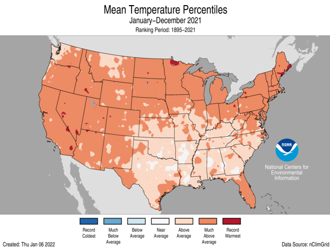
For 2021, the average contiguous U.S. temperature was 54.5°F, 2.5°F above the 20th-century average and ranked as the fourth-warmest year in the 127-year period of record. The six warmest years on record have all occurred since 2012. The December contiguous U.S. temperature was 39.3°F, 6.7°F above average and exceeded the previous record set in December 2015.
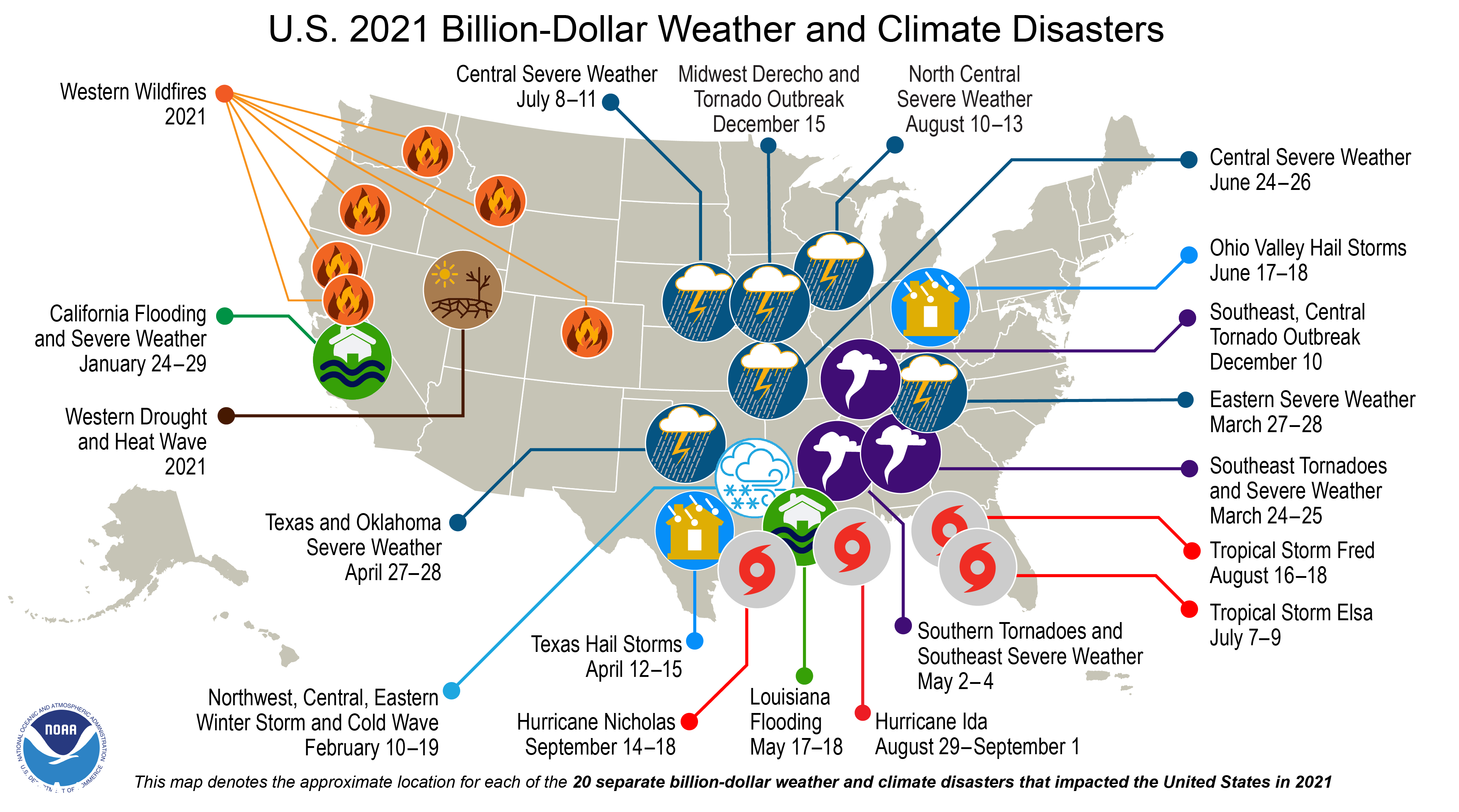
There were 20 separate billion-dollar weather and climate disasters in 2021, just two events shy of the record set in 2020. These events caused at least 688 fatalities and scores more injured. Two disasters occurred in December — the Southeast, Central Tornado Outbreak and the Midwest Derecho and Tornado Outbreak.
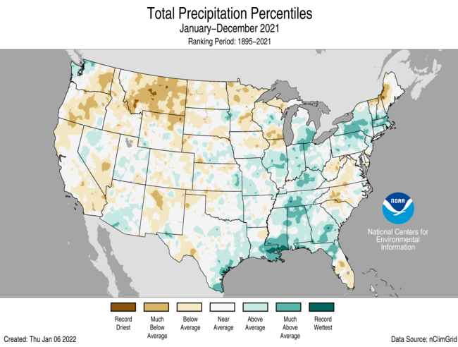
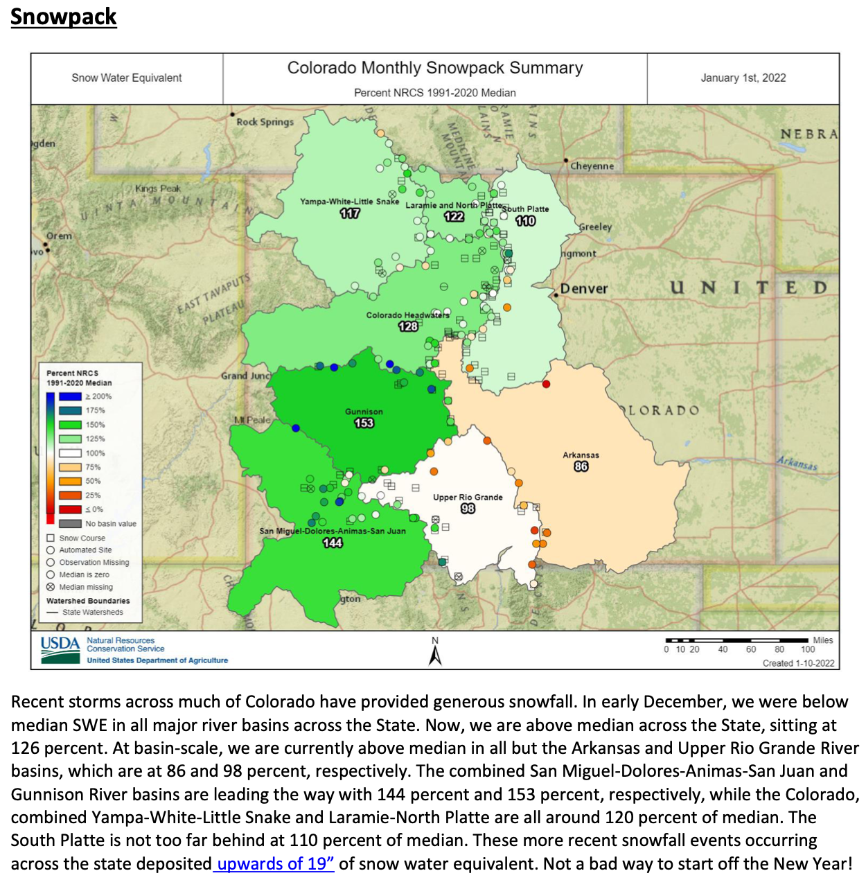
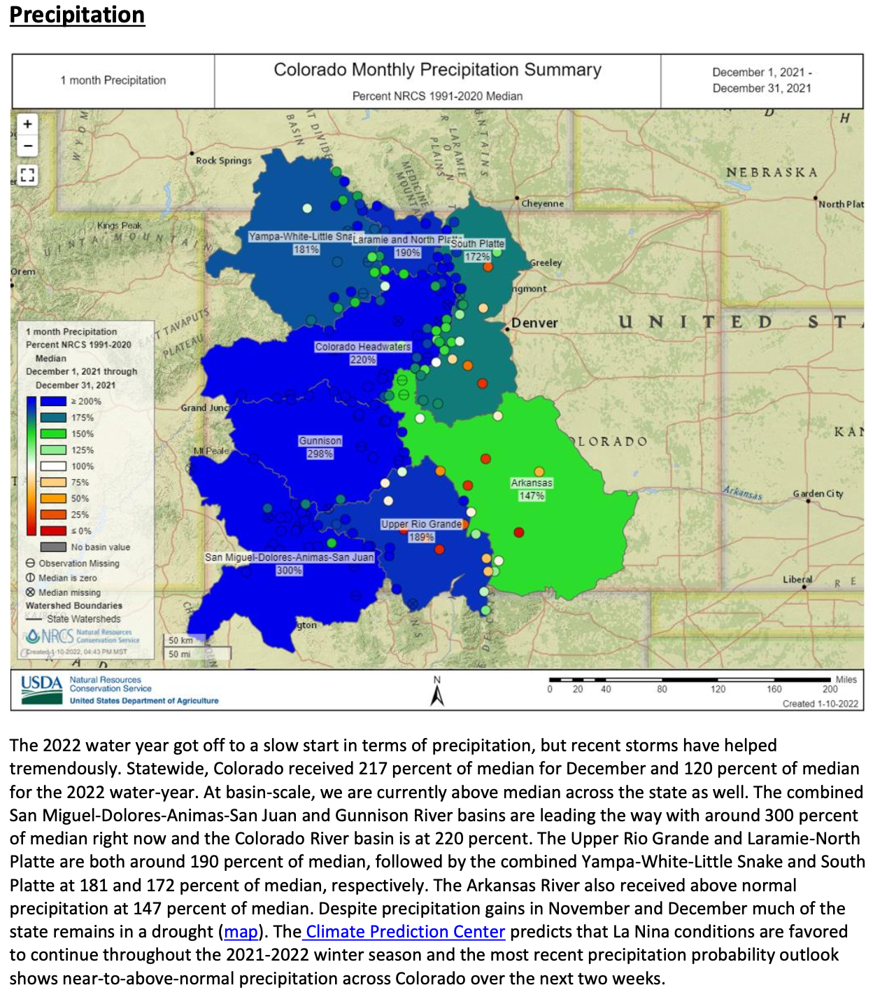
The annual precipitation total for the contiguous U.S. was 30.48 inches, 0.54 inch above average, ranking in the middle third of the historical record. Despite near-normal precipitation at the national scale, 2021 witnessed several significant events at the regional scale, including an above-average monsoon season across the Southwest and several atmospheric river events along the Pacific Coast. Drought remained extensive across much of the western U.S. throughout 2021.
This annual summary from the NOAA National Centers for Environmental Information is part of the suite of climate services NOAA provides to government, business, academia and the public to support informed decision-making.
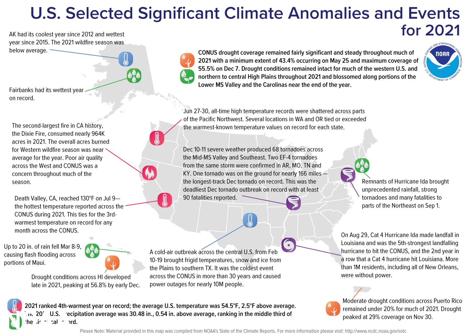
A map of the United States plotted with significant climate events that occurred throughout 2021.
Temperature
Most of the contiguous U.S. experienced above-average temperatures during 2021. Maine and New Hampshire both had their second-warmest year on record with 19 additional states across the Northeast, Great Lakes, Plains and West experiencing a top-five year. Temperatures were near average for the year in pockets across the South and Gulf Coast states.
A cold-air outbreak across the central U.S. from February 10-19 brought frigid temperatures, snow, and ice from the Plains to southern Texas and into the Mississippi River Valley. It was the coldest event observed across the contiguous U.S. in more than 30 years and caused power outages for nearly 10 million people as well as other costly impacts across 15 states.
A record-warm June across the contiguous U.S. ended with an unprecedented heat wave across the Pacific Northwest. Approximately 14.6 percent of the contiguous U.S. observed its warmest June on record. This is the largest extent of record warm temperatures on record for the U.S. during June.
A record-warm December across the contiguous U.S. was punctuated by record-warm temperatures across 10 states from the central Plains to the Gulf Coast. An additional 23 states from the Rockies to the East Coast ranked among their top-five Decembers.
The Alaskan statewide average annual temperature was 26.4°F, 0.4°F above the long-term average and was the coldest year since 2012. It was also the second year in a row with near-average annual statewide temperatures in contrast to the pronounced warmth across the state during 2014-2019. Despite the relatively mild year, Kodiak Harbor reported a temperature of 67°F on December 26. This is the highest December temperature on record for the entire state of Alaska, eclipsing the previous record of 65°F reported at Sitka Airport on December 12, 1944.
Precipitation
For the year as a whole, precipitation was above average in pockets from the Gulf Coast to the Great Lakes and into portions of the Northeast. Precipitation was below average across parts of the West, northern Rockies, Plains, western Great Lakes, Mid-Atlantic coast and parts of the Northeast and Florida.
A strong winter storm brought heavy snowfall to the central Rockies and High Plains March 13-14. Denver had its fourth-largest snowstorm on record while Cheyenne reported its heaviest multi-day storm on record. Blizzard conditions and heavy snowfall rates disrupted transportation throughout the region.
The Southwest monsoon season returned in July following two relatively inactive seasons. Tucson reported its wettest July and month on record followed by its wettest August on record. Consequently, flash flooding and fatalities resulting from the heavy rain were juxtaposed with the beneficial rainfall received from these events in the drought-stricken locations across the West and Southwest.
Several strong atmospheric river events from October to December along the West Coast brought ample rainfall and snow to several western states and mountain ranges. Drought intensity and coverage were reduced across some western states and end-of-year snowpack in the Sierra Nevada range broke December records, in excess of 200 percent of average at the end of the calendar year.
It was the wettest year since 2015 for the state of Alaska. Percentage of average precipitation received during 2021 varied by region with the West Coast region ranking wettest on record and the North Slope and interior regions receiving above-average precipitation. Meanwhile, parts of south-central Alaska and the Gulf regions received below-average precipitation for the year. Fairbanks had its wettest year on record with 18.74 inches of precipitation. This exceeded the previous record of 18.52 inches set in 1990.
According to theU.S. Drought Monitor (USDM), drought coverage for the contiguous U.S. remained fairly significant and steady throughout much of 2021 with a minimum extent of 43.4% occurring on May 25 and maximum coverage of 55.5% on Dec 7. Drought conditions remained intact for much of the western U.S. and northern to central High Plains throughout 2021 and blossomed along portions of the Lower Mississippi Valley and the Carolinas near the end of the year. Extreme (D3) and exceptional (D4) drought covered about 26.8 percent of the CONUS on August 17 — the largest extent of D3 and D4 drought in USDM history. Hawaii’s moderate (D1) to exceptional drought extent grew rapidly during the summer months, peaking at 59 percent in July and was most intense in November and early December with extreme and exceptional drought at nearly 11 percent coverage. Mid-December precipitation nearly eliminated drought across the islands by the end of the year. Drought across Puerto Rico ebbed and flowed throughout the year, peaking in November with 29 percent coverage; Alaska was nearly drought free during most of 2021.
Billion Dollar Disasters
Map of the U.S. plotted with 20 separate billion dollar disasters that occurred in 2021. For more, go to https://www.ncdc.noaa.gov/billions/.
During 2021, 20 weather and climate disaster events had losses exceeding $1 billion each across the U.S. These events include eight severe weather events, four tropical cyclone events, three tornado outbreaks, two flooding events, one drought/heat wave event, one winter storm/cold wave event and one wildfire event, that includes the December 30 Marshall Fire in Boulder County, Colorado. This is the second-highest number of events on record and is two events shy of the 2020 annual record of 22 events.
The U.S. disaster costs for 2021 exceeded $145 billion, which is the third-highest cost on record.
Hurricane Ida was the most costly event of the year ($75 billion) and ranks among the top-five most costly hurricanes on record (since 1980).
The historic mid-February winter storm/cold wave was the costliest winter storm on record ($24 billion) — in inflation-adjusted terms, twice as costly as the Storm of the Century in March 1993.
Disasters in 2021 have caused more than twice the number of fatalities than all the events that occurred in 2020 (688 versus 262) and were the highest in a decade for the contiguous U.S.
2021 marks the seventh consecutive year (2015-2021) in which 10 or more separate billion-dollar disaster events have impacted the U.S.
Since records began in 1980, the U.S. has sustained 310 separate weather and climate disasters where overall damages/costs reached or exceeded $1 billion (based on the CPI adjustment to 2021) per event. The total cost of these 310 events exceeds $2.16 trillion. Disaster costs over the last five years (2017-2021) exceeded a record $742 billion, reflecting the increased exposure and vulnerability of the U.S. to extreme weather and climate events.
Other Notable Extremes
During 2021, 21 named storms formed in the North Atlantic Basin. This was the third most-active Atlantic hurricane season on record. Above-average tropical activity across the Atlantic Basin occurred for the sixth year in a row.
Category 4 Hurricane Sam formed during September and was the most intense Atlantic hurricane of the season. Sam maintained Category 4 strength for several days and remained far from land in the central Atlantic Ocean.
On August 29, Category 4 Hurricane Ida made landfall in Louisiana and was the fifth-strongest landfalling hurricane to hit the contiguous U.S., and the second year in a row that a Category 4 hurricane hit Louisiana. More than 1 million residents, including all of New Orleans, were without power. Remnants of Ida merged with a frontal system and brought unprecedented rainfall, strong tornadoes and many fatalities to parts of the Northeast on September 1. Hurricane Ida was the strongest landfalling and most destructive hurricane of the season with end-of-year cost estimates at $75 billion.
It was an active wildfire year across the western U.S. with more than 7.1 million acres consumed, 96 percent of the 10-year average.
The second-largest fire in California history, the Dixie Fire, consumed nearly 964,000 acres in 2021.
Smoke from several large fires created air quality and health concerns across the West and contiguous U.S. throughout much of the season.
Wildfire activity across Alaska was below average and consumed approximately 253,000 acres in 2021 — only 22 percent of the 2011-2020 average.
Snowfall during the 2020-2021 snow season was consistently below average across the Sierra Nevada range and parts of the northern Rockies. Several storm systems in January and the cold-air outbreak in February brought significant snowfall to the Lower 48. By February 16, snow covered 73.2 percent of the contiguous U.S — the highest daily value in the historical record. Additional late-season snowfall occurred in March, bringing record snowfall to portions of the central Rockies and High Plains and in April across the Ohio Valley and Northeast.
The 2021 preliminary tornado count was above average across the contiguous U.S. with 1,376 tornadoes reported. 193 December tornadoes were confirmed by early January 2022 — the greatest number of tornadoes for any December on record and nearly twice the previous record of 97 in 2002.
The most notable events during the year include two outbreaks, with a combined total of about 100 tornadoes, including an EF-4 tornado, on March 17 and March 25 across Dixie Alley, an outbreak in Iowa on July 14, the December 10-11 Mid-Mississippi River Valley Tornado event that spawned two EF-4 tornadoes, and the December 15 Midwest derecho event that produced more than 60 tornadoes across Nebraska and Iowa — the most tornadoes confirmed on any day during 2021. No EF-5 tornadoes were reported during 2021. The most recent tornado classified as an EF-5 occurred in 2013.
Portions of the Northeast, including Pennsylvania, Delaware, New Jersey and New York, experienced a very active tornado season in 2021 with seven days of severe weather producing more than 30 tornadoes across the region.
The Mid-Mississippi River Valley experienced an historic severe weather event on December 10-11 — the Quad State Tornadoes — that produced two long-tracked EF-4 tornadoes across Arkansas, Missouri, Tennessee and Kentucky. The longest tornado track was nearly 166 miles across Kentucky and a small portion of Tennessee. This is a record length for the month of December, the longest-tracked tornado on record in Kentucky and the ninth-longest tornado track on record for the country. Damage estimates are ongoing and are in excess of $3.9 billion.
The U.S. Climate Extremes Index (USCEI) for 2021 was 115 percent above average and ranked third highest in the 112-year record, second highest when taking the tropical cyclone indicator into consideration. Warm extremes in both maximum and minimum temperature across much of the U.S., in addition to dry Palmer Drought Severity Index values and extremes in 1-day precipitation across the U.S., contributed to this elevated USCEI value. The USCEI is an index that tracks extremes (falling in the upper or lower 10 percent of the record) in temperature, precipitation, drought and landfalling tropical cyclones across the contiguous U.S.
To say that Aurora has a prolific portfolio of water rights and reservoirs is apt. Spanning across three water basins, Aurora water is transported 180 miles through a vast and complicated system.
But it hasn’t always been that way…
Aurora was wholly served by the City and County of Denver until 1954, when Denver put into place a “blue line” no longer granting permits for new taps in the ever-growing metropolitan area, leaving parts of Aurora out of Denver’s service region.
In 1957, Aurora purchased the water rights to the Last Chance Ditch and diverted the water that ran through it to be stored near the Cherry Creek Dam.
The completion of phase one of the Homestake Reservoir, which the city shares with Colorado Springs, was in 1967 and with that, Aurora was able to become completely self-reliant when it came to supplying the wet stuff to its residents.
The next 20 years saw rapid growth of Aurora’s water rights acquisitions, including rights in the three major basins being Colorado, Arkansas and South Platte. The city has continued to purchase water rights in areas spanning from Park to Eagle counties.
While the water rights are large in number for Aurora, 95% of the municipality’s water comes from reusable water…
Prairie Waters schematic via Aurora Water.
This is where the Prairie Waters filtration system plays its vital role in supply for the city. Meeting approximately 10% of the demands of the city’s water, the system begins at the South Platte River in southern Weld County, and through a system of 23 wells, water is ushered through hundreds of feet of sand and gravel which serves as a filter to clean out impurities in the water. It is then pumped into basins where it goes through another level of filtration removing even more contaminants. The water is then sent to one of three different pump stations and finally to a purification facility.
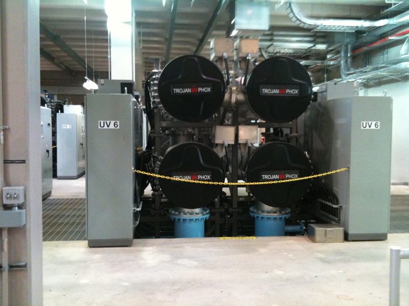
UV pretreatment Peter D. Binney Purification Facility.
The Peter D. Binney Purification Facility uses what are some of the most advanced processes of purification in the country, through ultraviolet oxidation, water officials say. With the ability to treat 50 million gallons a day, it’s the largest facility in the nation to use this technology…
With Aurora’s acquired water rights and the Prairie Waters System, Aurora looks to be prepared for the city’s growth.
Aurora Water serves more than 91,000 accounts in a city of more than 386,000 people and that number is rapidly increasing. The population is expected to double in the next 30 to 40 years.
With a bevy of new housing developments popping up on the eastern plains, it’s imperative that Aurora has the water to serve the increasing population with the most recently announced development promising 5,000 new homes.
Aurora water managers have long said that the city is set to provide water to tens of thousands of additional residents for at least another half century. Projections have shown that the city could need more than 40 billion gallons of water a year by 2070, more than double the usage in 2015.
In order to accommodate that amount, there needs to be ample storage, and Aurora has plans for that, too. Aurora currently has 156,000 acre feet of water storage, and enough to provide water to the city for three years, were there not to be another drop.
With 12 current reservoirs along the front range and throughout the mountains, Aurora has plans for three more reservoirs throughout the next 50 years.
One such reservoir has a litany of hurdles to jump, and might even require an act of Congress.
This map shows the location of test holes Homestake Partners plans to drill as part of its geotechnical investigation into the feasibility of a dam site in the Homestake Creek valley. The Forest Service has received more than 500 comments, most of them in opposition to, the drilling and the overall reservoir project. Credit: USFS via Aspen Journalism
The proposed Whitney Reservoir on U.S Forest land in Eagle County would be shared with Colorado Springs. U.S. Forest Service District Ranger Leanne Veldhuis approved the plan this spring allowing the cities to test for possible sites…
With 95% of Aurora’s water being surface, or reusable water, there is always the risk of a low snow-pack, quick evaporation or plain-old drought. The new reservoirs will prevent Aurora having to sell or lease water resulting from not having enough storage.
Wild Horse Reservoir, which looks to be the next reservoir completed, hopefully by decades end, was planned with the purpose of not only providing adequate and better storage, but work in providing better management of exchanged water.
The second half of 2021 was the warmest such period in recorded Colorado history, according to data released Monday by the National Oceanic and Atmospheric Administration.
The national data includes temperature and precipitation statistics from December, which recorded monthly averages that were 7 degrees Fahrenheit warmer and had higher levels of drought than long-term averages recorded since the turn of the century, the data show. The warm and dry weather in the Front Range combined with a powerful wind storm that helped drive the Marshall fire, the most destructive fire in state history…
The average statewide temperature in those six months was 53.4 degrees, more than four degrees higher than long-term averages, the data show. The state had its highest average maximum and minimum temperatures in that period, according to NOAA data.
It was also the driest six-month stretch for the Denver metro, which received just over an inch of rain in that period, Wilkinson said.
Some other statistics from 2021:
It was Colorado’s fourth-warmest year on record. Seven of the 10 warmest years have occurred in the last 20 years, NOAA data show
Unlike 2020, the second-driest year in modern history, 2021 had just an inch less precipitation than average
However, precipitation varied greatly across the Continental Divide in the second half of the year. The Western Slope had above-average precipitation, while the Front Range was much drier. “At the beginning of the year in 2021, we had some monsoon moisture,” Wilkinson said. “When we started going into summer, we just hit a really dry period.”
The Denver metro had less than one-tenth of an inch of precipitation in November and no measurable snowfall. The average for the month is six-tenths of an inch, Wilkinson said
Other western states also had their warmest July to December period on record, including Utah, Wyoming and New Mexico
Warmer, drier weather has become more common in the west due to human-caused climate change, according to meteorologists.
Gov. Pete Ricketts said Tuesday his mid-biennium budget recommendations to the Legislature will include a $500 million appropriation to construct a canal system to ensure Nebraska’s continued access to South Platte River water flowing into the state from Colorado.
“Upon approval, we’ll engage stakeholders on project location and design,” Ricketts wrote in his weekly newsletter.
The governor will address the Legislature on Thursday for his annual State of the State address.
“Given the state’s strong financial position, budget resources are available to undertake this historic project without incurring a penny of debt,” the governor said.
Ricketts first spoke of the proposal during a news conference Monday, but detailed his plans in the newsletter, including his decision to proceed immediately with an appropriation this year of the resources required to complete the project.
“Colorado’s plans to siphon off water from the South Platte River (before it flows into Nebraska) would decrease agricultural water supplies and raise pumping costs for our residents,” the governor said.
“It would jeopardize municipal water supplies for Lincoln, Omaha and other Platte River communities.
“The loss of water would threaten the cooling water supplies for Gerald Gentleman Station, Nebraska’s largest electric-generation facility” and undercut the state’s capacity to generate hydroelectric power while increasing costs and regulatory burdens, Ricketts said.
“Constructing the canal is the primary means for Nebraska to exercise our legal rights to water flows from the South Platte River,” he said.
Ricketts had earlier said Nebraska will exercise its rights under the South Platte River Compact signed in 1923 to waters flowing from the Rocky Mountains through Colorado into the state, acting in the face of plans in Colorado to build projects “to ensure no ‘excess’ water leaves its state.”
That action, undertaken in the form of nearly 300 projects, “threatens to choke off the flow of water into Nebraska,” Ricketts said, with estimates of almost a 90% loss…
Kevin Rein, Colorado’s state engineer and director of the state’s water resources division, told The Associated Press that officials will work with Nebraska to fully understand the proposal and ensure that Colorado’s interests are protected while respecting Nebraska’s rights under the agreement.
Governor Clarence J. Morley signing Colorado River compact and South Platte River compact bills, Delph Carpenter standing center. Unidentified photographer. Date 1925. Print from Denver Post. From the CSU Water Archives
Major Stephen Long described the Plains as the “Great American Desert” when his expedition studied our region in 1820. “It is almost wholly unfit for cultivation, and of course, uninhabitable by a people depending upon agriculture for their subsistence,” wrote his group’s geographer. Fast forward 200 years, and Nebraska has developed into a global powerhouse of agricultural production. We rank #1 in the nation in agricultural cash receipts per capita.
How have Nebraskans transformed the “Great American Desert” into some of the most productive ag land in the world? Through our inventive and responsible use of water resources. While we’ve used these resources wisely, the actions of our neighbors in Colorado threaten to deplete them.
The water we depend on for agriculture, drinking water, and other uses isn’t confined within our state’s borders. The Ogallala Aquifer underlies eight states, and rivers like the Republican River and Platte River flow across state lines in and out of Nebraska. Over the years, we’ve negotiated agreements with surrounding states regarding our shared water resources.
One such agreement is the South Platte River Compact that Nebraska signed with Colorado nearly 100 years ago, in 1923. It regulates the use of the waters of the South Platte River, which originates in the Rockies and flows through Colorado into Nebraska.
Colorado is currently planning nearly 300 projects and over $10 billion of expenditures to ensure no “excess” water leaves its state. This threatens to choke off the flow of water into Nebraska.
The Nebraska Department of Natural Resources (NeDNR)—working with the Attorney General’s Office, natural resources districts (NRDs), and public power districts in our state—has been vigilantly watching developments in Colorado. NeDNR estimates that Colorado’s plans, when fully implemented, will cause a nearly 90% reduction in flows coming into Nebraska from Colorado.
This would dramatically impact Nebraskans. Colorado’s plans to siphon off water from the South Platte River would decrease agricultural water supplies and raise pumping costs for our residents. It would jeopardize municipal water supplies for Lincoln, Omaha, and other Platte River communities. The loss of water would threaten the cooling water supplies for Gerald Gentlemen Station, Nebraska’s largest electric generation facility. The decreased flow would also undercut our capacity to generate hydroelectric power in Nebraska. The reduction in water would almost surely increase costs and regulatory burdens for the State, our NRDs, and water users.
The good news is that the South Platte River Compact entitles Nebraska to construct a canal to ensure access to our fair share of the South Platte River’s water. The agreement specifically provides Nebraska authority over water and land in Colorado for the project.
On January 10th, I announced Nebraska’s intention to construct this canal—pending the Unicameral’s approval—to protect our water users from reduced South Platte River flows. My mid-biennium budget recommendation for the Legislature will include $500 million for the canal project. Upon approval, we’ll engage stakeholders on project location and design.
Constructing the canal is the primary means for Nebraska to exercise our legal rights to water flows from the South Platte River. If we fail to act now, Nebraska could see sharply reduced inflows from the South Platte River. As I already mentioned, this would have a devastating impact on our state. By taking initiative to build the canal, we’re protecting Nebraska’s water rights for our kids, grandkids, and generations beyond. Given the State’s strong financial position, budget resources are available to undertake this historic project without incurring a penny of debt.
Nebraska’s way of life depends on access to our state’s abundant water resources. We’ve been great stewards of our water through the years. For example, we’ve maintained the Ogallala Aquifer, on average, within one foot of where it was in the 1950s. We’ve done all of this while developing into a global leader in agricultural irrigation.
The High Plains Aquifer provides 30 percent of the water used in the nation’s irrigated agriculture. The aquifer runs under South Dakota, Wyoming, Nebraska, Colorado, Kansas, Oklahoma, New Mexico and Texas.
Inventions like the center pivot, the development of drought-resistant hybrid crops, and the use of precision irrigation techniques have optimized our use of water resources. The Daugherty Water for Food Global Institute estimates that crop water productivity for corn and soybeans in Nebraska increased 75% from 1990 to 2014. In other words, our farmers are continuously growing more crops with less water.
All of Nebraska stands to gain when we preserve, protect, manage, and engage in good stewardship of our water supply—and all stand to lose if we fail to do so. Our ag producers are reliant on water supplies as they work to feed the world. Communities from Ogallala to Omaha depend on the Platte River for drinking water. We use water from the Platte River to generate power, and the river is crucial to the quality of our natural environment as well.
I urge the Legislature to act now and protect our water supplies from being irreversibly diminished. You can help by reaching out to your State Senator to make your voice heard. Their contact information is available at http://www.NebraskaLegislature.gov.
If you have questions about the proposed canal, write me at pete.ricketts@nebraska.gov or call 402-471-2244. Let’s seize the moment to make sure future generations of Nebraskans can enjoy the water resources they’re entitled to.
FromThe High Country News [January 1, 2022] (Christine Trudeau and Kalen Goodluck):
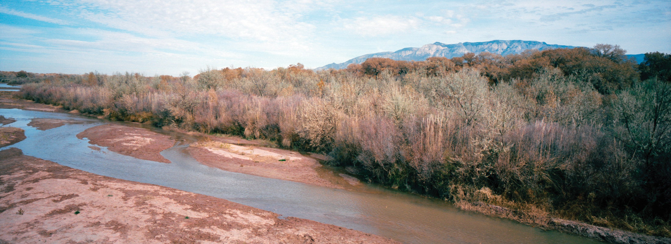
On a late November morning, Julia Bernal walked a stretch of riverbank along the Rio Grande in Sandoval County, New Mexico, between Santa Ana and Sandia Pueblo. Bernal pointed out the area between the cottonwood trees and the edge of the Rio Grande, a 30-foot stretch of dry earth covered in an ocean of tiny pebbles intermixed with periodic sandbars, tamarisk and willow shrubs.
“It never used to look like this,” Bernal said. “The reason the cottonwoods look the way that they do is because of the Cochiti Dam — that hyper-channelization of the river did cause this riparian forest to just kind of (disappear) along with it.”
Bernal grew up in the 1990s watching the river shrink every year, even as Sandia Pueblo, where she is enrolled, and other Rio Grande pueblos were left out of the state’s surface-water management process. Knowing that her community’s water, central to its culture, was in danger, Bernal resolved to work in the water sector after she graduated college in 2016, perhaps in the Bureau of Indian Affairs or the U.S. Fish and Wildlife Service. But everything changed later that year.
Bernal, along with the rest of the world, watched as tribal communities came together at Standing Rock to fight the Dakota Access Pipeline. The event galvanized her, forcing her to confront the fact that it was impossible to work on behalf of the Rio and the pueblos without centering the Indigenous environmental justice perspective. The time had come — for Standing Rock, for the pueblos, for all Indigenous communities — to enforce their sovereign right to lead on water policy.
Julia Bernal (Sandia, Taos and Yuchi-Creek Nations of Oklahoma) in Sandoval County in the Middle Rio Grande Valley. “It’s like this concept of landback. Once you get the land back, what are you going to do with it after? It’s the same thing. If we get the water back, what are we gonna do with it after? How are we going to maintain water?” Bernal, the director of the Pueblo Action Alliance, believes that “landback” can’t happen without “water back.” Kalen Goodluck/High Country News
“It was a fight to protect water, but also protect culture, respect treaties,” Bernal said. “It taught me a lot about how any sort of planning initiative is going to include some sort of justice component if you’re dealing with Indigenous peoples.”
Later that year, Bernal helped found the Pueblo Action Alliance, which she directs. The organization, which prioritizes youth involvement, aims to advocate for the pueblos’ water rights and explain their complex history. Bernal is determined, she said, to “ensure that not just tribal nations but communities also have participation in decision-making processes.”
Bernal is not alone — far from it. She is part of an intergenerational group of Pueblo women working, advocating and organizing on behalf of the 19 pueblo nations and their right to be policy leaders when it comes to the future of the Rio Grande. Bernal and her contemporaries fight on several fronts at once: Convincing state and local governments to recognize their legal water rights; getting those rights quantified by the courts; and navigating the reality that pueblo nations have to depend on federal officials to actually enforce the existing water-quality regulations. The state has put the pueblos in a tenuous position regarding water rights, particularly given the two-decade-long drought, and these community leaders are done waiting for the state and federal governments to act.
The Southside Water Reclamation Plant, which treats wastewater sewage from Albuquerque homes before releasing it into the river, sits on the southern edge of the city, just five miles from the boundary of the Pueblo of Isleta. Kalen Goodluck/High Country News
Indigenous water rights are intensely, often frustratingly, shaped by centuries-old colonial law. The disbursement of water within the United States is determined by a process that prioritizes what are known as senior water rights. According to Indian law and civil litigation attorney Richard Hughes, most federally recognized tribes generally have the most senior water rights across the country, secured by a 1908 Supreme Court Decision known as Winters v. United States. The legal precedent for pueblo water rights, however, can also stem from the Mechem Doctrine, from New Mexico v. Aamodt, which holds that the pueblos’ aboriginal water rights were solidified by the Treaty of Guadalupe Hidalgo, signed by the U.S. and Mexico in 1848. Despite their senior status, tribes often wait decades — some for over a century — to have their rights quantified through litigation or settlement with New Mexico and subsequent congressional approval. Whether through Winters or the Mechem Doctrine, this process is particularly cumbersome for the pueblo nations, Hughes says, which are often required to have a documented “precedent for what the tribe would be entitled to were the case to be fully litigated.”
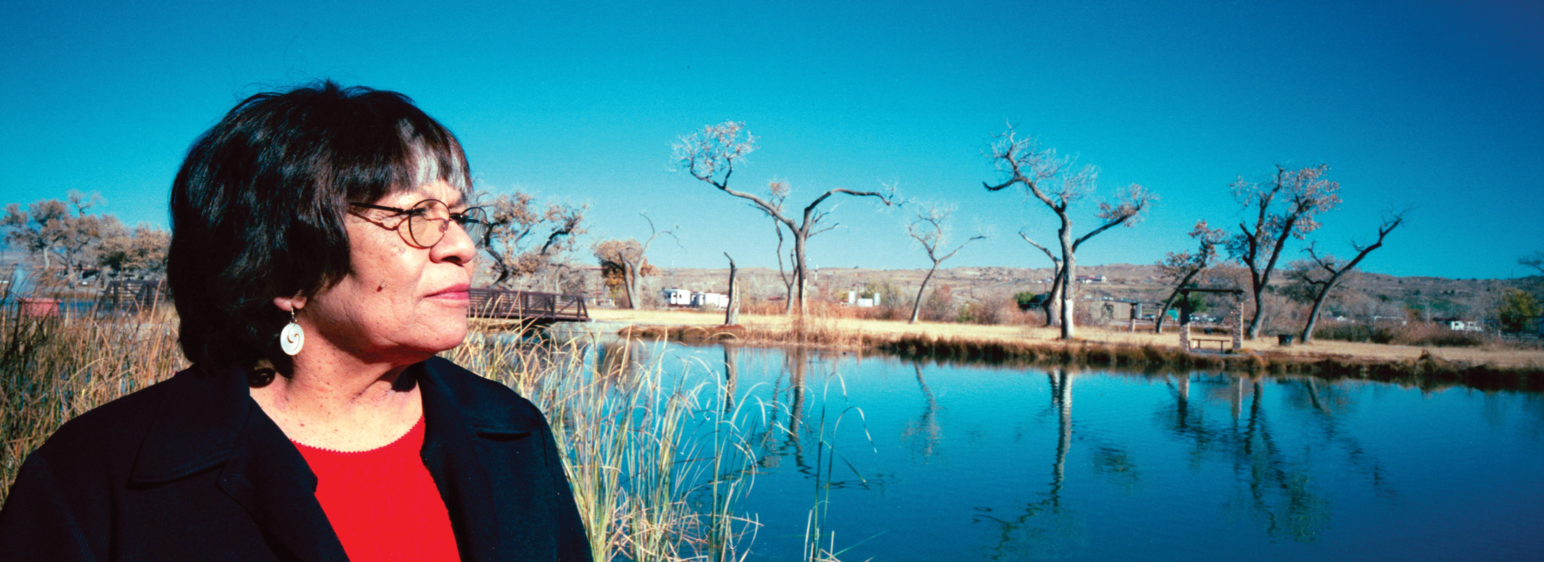
Judge Verna Teller (Isleta Pueblo) in the Middle Rio Grande Valley at the Isleta Lakes, just south of Albuquerque, New Mexico. “Every day, I thank the Creator that our standards haven’t been challenged, and they’re still active and alive today,” said Teller. “They put the onus on the tribe because we have permitting authority, so we have to monitor the river. We have to monitor that they’re maintaining as much as possible.” Kalen Goodluck/High Country News
Thanks to New Mexico’s attitude, the opportunity for such litigation abounds. In 2020, the pueblos of Santa Ana, Jemez and Zia withstood an attempt by the state to diminish their aboriginal water rights along the Jemez River. The case was the latest entry in a decades-long campaign of antagonism by New Mexico — the very environment that taught Judge Verna Teller how to leverage her people’s sovereignty.
Teller, chief justice of Isleta Pueblo, grew up just south of Bernal. And like Bernal, Teller witnessed disconcerting changes in the river. Like other Isleta community members, she was unnerved by the discolored foam in the Rio. After traditional elders had to stop using water in ceremonies in the mid-1980s, they asked Teller to find out what was wrong.
“I just felt obligated to help, because I knew it wasn’t just for them,” said Teller. “It was for the whole community, and for everybody in the future — our children, our babies that weren’t born yet.”
Treated wastewater flows into the Rio Grande from Albuquerque’s Southside Water Reclamation Plant, which treats wastewater sewage, just five miles north of the Pueblo of Isleta’s boundary. Kalen Goodluck/High Country News
Before long, elders realized Teller needed to be in a position of authority to hold local and state agencies accountable. Teller was only 35 when traditional elders asked her to run for governor of Isleta Pueblo, and she faced an uphill battle, given the existing council’s gender-based discrimination. But once in office, she was able to work with various agencies, legal experts and hydrologists to establish a water-quality standard for Isleta. It took a decade of legal tussling with the city of Albuquerque, but under Teller’s guidance, in 1998, Isleta became the first tribal nation to establish water-quality standards under the Clean Water Act.
“It was all spirit,” she said. “I still really get emotional when I think about it, because it was so important to us. As mortals, as humans, we don’t realize sometimes how powerful spirit is. They come to your aid when you need it.”
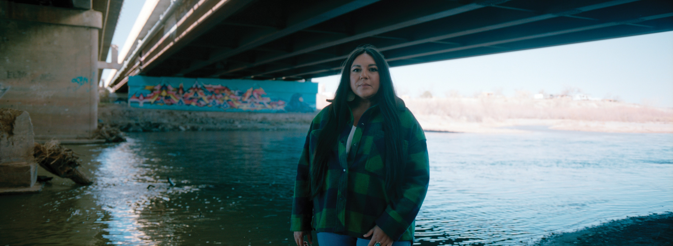
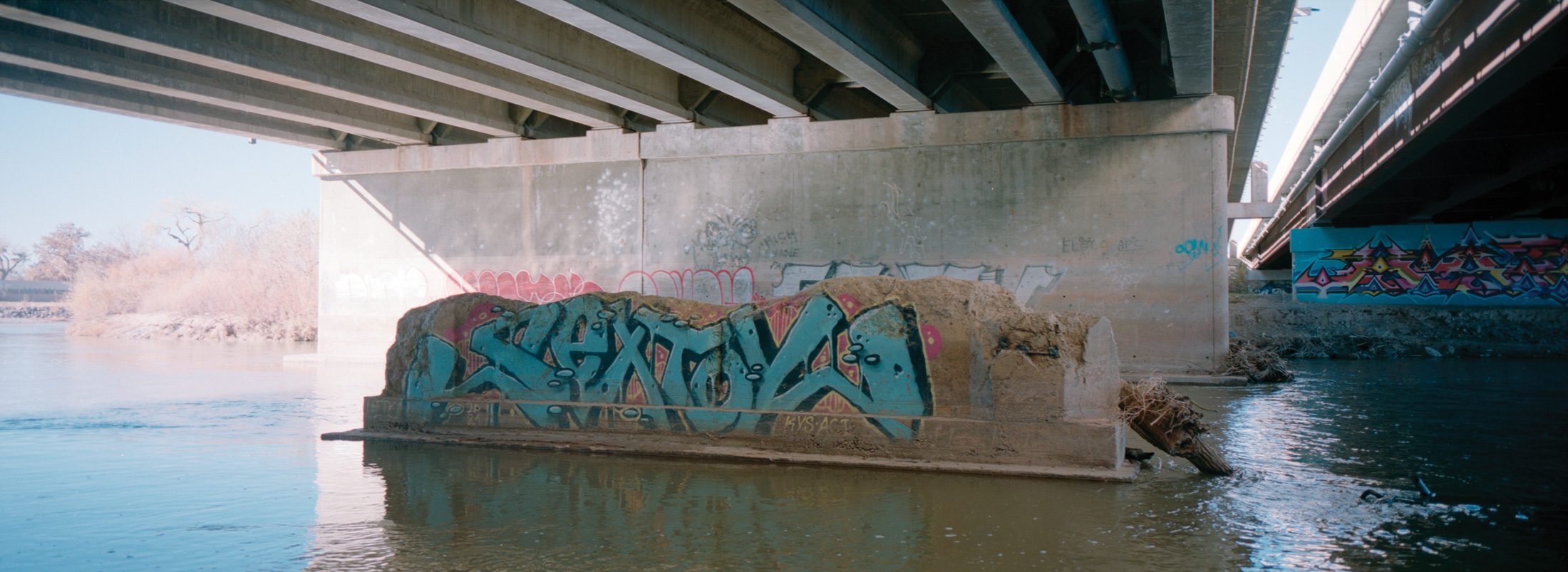
The Rio Grande flowing underneath a bridge on U.S. 550 in Bernalillo, New Mexico, in late November 2021. Kalen Goodluck/High Country News
Over the years, however, alleged violations by the city have rarely been punished by federal agencies. And as Teller pushes for Isleta’s government to use its regulations to hold New Mexico accountable, others, like Phoebe Suina, also work to ensure that the pueblos keep fighting for their rights to the river and for the Rio’s water quality.
Suina, who hails from the Pueblos of San Felipe and Cochiti, is a hydrologist by training and the owner of High Water Mark, an Indigenous-women-led environmental consulting company that focuses on water-resources engineering. “We really need to address the water quality along with the water quantity in this very rigid, restricted framework,” Suina said. Like Teller and Bernal, Suina is still grappling with the overarching question that has defined every facet of this struggle: Is adjudication — going to court to obtain a more permanent answer on water rights and quantification — the best way to strengthen Indigenous water rights? And if not, what long-term strategy should the Pueblo nations pursue to achieve justice, given the flexibility that climate change is going to demand?
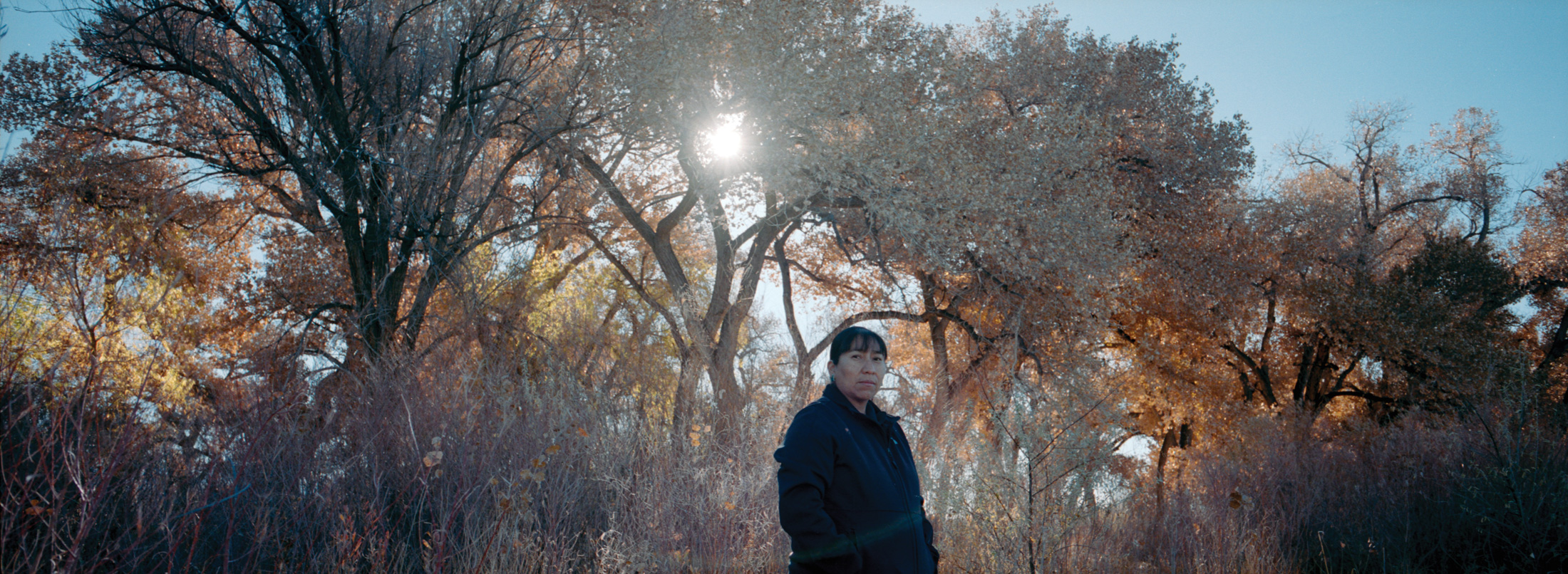
Phoebe Suina (Pueblos of San Felipe and Cochiti) at Alameda Open Space, on the Rio Grande. “Science has said, ‘A majority of what you are made of, a majority of what I am made of, is water.’ So what we’re talking about in terms of water rights, it is you, it is me.” Kalen Goodluck/High Country NewsThe Rio Grande as seen from Albuquerque, New Mexico, in the Middle Rio Grande region. Quantifying water rights through litigation or settlement is a lengthy process, one that could easily outlast our lifetime, according to Richard Hughes, an Indian law and civil litigation attorney. What it could mean, if adjudicated, is that the rights of the Middle Rio Grande pueblos would finally be defined — inarguably — as superior to non-Native entities and governments. “It would completely turn the whole water-rights situation in the basin on its head,” Hughes said. Kalen Goodluck/High Country New
Christine Trudeau, Prairie Band Potawatomi, is a contributing editor for the Indigenous Affairs desk at High Country News, and the Indigenous Investigative Collective’s COVID-19 project managing editor. Follow her on Twitter @trudeaukwe or email her at christine.trudeau@hcn.org.