End in sight for natural gas bridge?: Filings by #Colorado’s two largest utilities reveal debate about how much longer natural gas will be vital to ensuring reliable electrical deliveries — @BigPivots

Hydrocarbon processing in the Wattenberg Field east of Fort Lupton, Colo., on July 2, 2020. Photo/Allen Best

From Big Pivots (Allen Best):

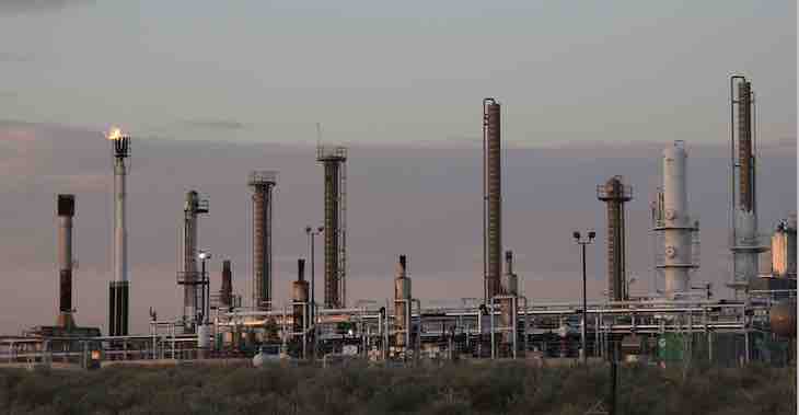
Natural gas a decade ago was being called the bridge fuel. Burning it produces half the emissions of coal, yet it can be tapped to ensure reliable delivery of electricity. It was the bridge to a low-emissions future.

Today, natural gas is where coal was 10 or 15 years ago. We still need it for electrical generation, but the bridge no longer seems endless. But will new natural gas plants end up being like many coal plants, assets stranded long before the debt is paid?

The role of natural gas in Colorado’s energy future is being sorted out in proposals submitted to state regulators by Colorado’s two largest electrical utilities: Xcel Energy and Tri-State Generation and Transmission. Together, they deliver 71% of electricity.

These utilities expect to achieve 80% and even higher reductions in emissions associated with electrical generation by 2030 as compared to 2005 levels. Both the technology and economics of renewables and now storage align with these goals.

The preferred plan by Tri-State, the wholesaler for 17 of Colorado’s 22 electrical cooperatives, takes a wait-and-see position about new natural gas-fired generation during the next few years.

In a September filing, Lisa Tiffin, the senior manager for analytics and forecasting, explained that this will “allow emerging technologies to become more competitive in the interim and potentially displace the need” for new natural gas generation.

Most people, when buying a house, take on a 30-year mortgage. An agreement filed with state regulators last week by Tri-State, along with environmental groups, state agencies and others, calls for a shorter depreciation of just 20 years when evaluating the cost of any potential new natural gas plant.

This makes new natural gas much more difficult to justify. This shorter timeline also accords with Colorado’s statutory timeline for achieving a 100% near carbon-free electrical generation by 2050.

But what will be needed to meet demand if, for example, Colorado has a heat dome type of event in 2030 similar to that which baked people to death in Portland last June? Air conditioners would be blasting — and the wind turbines may be motionless.

That’s a central question in the plans for Xcel Energy. In addition to its own customers, the utility delivers wholesale power to utilities that serve Aspen, Vail, plus Steamboat Springs and Craig.

Xcel wants to install natural gas generation at an existing coal plant in Pawnee, which is in northeastern Colorado, beginning Jan. 1, 2026. Environmental groups are on board with this, although some want an even earlier switch.

Western Resource Advocates and other environmental groups, however, are not on board with Xcel building other new gas plants. Xcel estimates it will invest $1 billion in natural gas capacity. Those gas plants, it says, will be used rarely but necessarily to ensure reliability.

The Colorado Oil and Gas Association supports Xcel’s plans and wants to see no time wasted. Natural gas, it said in a filing last week, will “play this critical reliability and resilience role that makes renewable energy possible.”

The industry group also supports Xcel’s argument that the natural gas infrastructure can later be adapted to use green hydrogen, if and when that technology becomes affordable. Renewable energy and water are used to create green hydrogen, which can be stored. COGA and Xcel say another potential path is to use natural gas plants retrofitted with carbon capture and storage technology. That technology also cannot yet compete in cost or scale.

Environmental groups argue instead for battery storage, already part of Xcel’s plans, playing an even larger role. Interwest Energy Alliance, representing primarily wind developers, accused Xcel last week of old-school thinking: “The technological changes that are coming to the entire utility industry are unfathomable to those stuck in the central station combustion thought paradigm.” Batteries, though, remain an imperfect solution.

The Colorado Energy Office wants Xcel to be required to invest in demand-response programs, shifting demand and suppressing it through energy efficiency. This, it points out, will be less expensive than Xcel investing in up to 300 megawatts of additional gas generation.

What all agree is that Xcel’s filing constitutes a landmark. Perhaps never before has the state’s Public Utilities Commission seen a proposal for so much rapid change. One example: the social cost of carbon is being used for the first time to evaluate proposals. Xcel, in a related proposal, wants to spend $2 billion alone on new transmission. The energy landscape has changed — and likely will change just as dramatically in the next decade.

The state’s three PUC commissioners are expected to issue a decision sometime in March about both the Tri-State and Xcel pivots. Part of those big decisions will be about the role of natural gas.

Article: Tree mortality response to drought-density interactions suggests opportunities to enhance #drought resistance — British Ecological Society

Pinus ponderosa subsp. ponderosa. Photo credit Wikimedia.

Click here to read the article (John. B. Bradford, Robert K. Shriver, Marcos D. Robles, Lisa A. McCauley, Travis J. Woolley, Caitlin A. Andrews, Michael Crimmins, David M. Bell). Here’s the abstract:

  1. The future of dry forests around the world is uncertain given predictions that rising temperatures and enhanced aridity will increase drought-induced tree mortality. Using forest management and ecological restoration to reduce density and competition for water offers one of the few pathways that forests managers can potentially minimize drought-induced tree mortality. Competition for water during drought leads to elevated tree mortality in dense stands, although the influence of density on heat-induced stress and the durations of hot or dry conditions that most impact mortality remain unclear.
  2. Understanding how competition interacts with hot-drought stress is essential to recognize how, where and how much reducing density can help sustain dry forests in a rapidly changing world. Here, we integrated repeat measurements of 28,881 ponderosa pine trees across the western US (2000–2017) with soil moisture estimates from a water balance model to examine how annual mortality responds to competition, temperature and soil moisture conditions.
  3. Tree mortality responded most strongly to basal area, and was elevated in places with high mean temperatures, unusually hot 7-year high temperature anomalies, and unusually dry 8-year low soil moisture anomalies. Mortality was also lower in places that experienced unusually wet 3-year soil moisture anomalies between measurements. Importantly, we found that basal area interacts with temperature and soil moisture, exacerbating mortality during times of stress imposed by high temperature or low moisture.
  4. Synthesis and applications. Our results imply that a 50% reduction in forest basal area could reduce drought-driven tree mortality by 20%–80%. The largest impacts of density reduction are seen in areas with high current basal area and places that experience high temperatures and/or severe multiyear droughts. These interactions between competition and drought are critical to understand past and future patterns of tree mortality in the context of climate change, and provide information for resource managers seeking to enhance dry forest drought resistance.

A giant loop #water system around El Paso County might help utilities plan for the future — KRCC

Denver Basin Aquifer System graphic credit USGS.

From KRCC (Shanna Lewis):

As the population grows along the Front Range, many water utilities in El Paso County are seeing declines in the productivity of wells that draw from the Denver Basin, a geological formation that stretches north into Weld County and across much of the Front Range.

Some water managers are looking at a potential $134 million project that could help them, now and in the future…

The Cherokee Metropolitan District is among the handful of water utilities looking at ways to work together to circulate water between the farthest northern and southern reaches of the county.

The idea is to use new and existing infrastructure — like the big blue pipeline — to create a giant loop system that could take water flowing south in Monument and Fountain creeks and pump it north again through ditches and pipelines.

Woodmoor Water and Sanitation District is another primary collaborator in the project. The utility supplies water to residents in the northern part of the county, but has water assets in the southern part, including a quiet 80-acre lake called the Callahan Reservoir. It could become part of the Loop system too…

A map being shown around El Paso County by suburban water agencies traces the path of the Loop, a complex $134 million pipeline and pumping project that would allow northern and eastern communities in the county to reuse aquifer water returning to Fountain Creek, and pipe along water rights they have bought up on the southern side of the county. (Provided by Woodmoor Water and Sanitation District)

Manager Jessie Shaffer says because of declines in their Denver Basin wells, the utility purchased surface water rights from Fountain Creek.

“But the problem is those renewable water rights are located just south of the city of Fountain,” Shaffer said. “We need a way to transport those water supplies.”

The proposed Loop would allow Woodmoor and other districts to get to water they own the rights to but haven’t been able to access. It would also allow them to more easily recycle indoor wastewater that comes from Denver Basin wells and now drains into the sewer…

“Water is absolute. It is game, set, match,” she said. “If you don’t have water, your highways don’t matter. Your human services don’t matter. All of those issues don’t matter if there’s not water. So we have to get the water equation finished, we have to find the long-term answer.”

A 19th-Century Plan for a #Colorado to Nebraska Canal Lacks Key Details, Causing Nebraskans to Ask: ‘Is this Worth the Cost?’ — #Nebraska Public Media

The South Platte River Basin is shaded in yellow. Source: Tom Cech, One World One Water Center, Metropolitan State University of Denver.

From Nebraska Public Media (Jackie Ourada):

Capability and feasibility are a few of the bigger questions from some water experts, such as Joel Schkneekloth, a water specialist at Colorado State University.

“It was something I had never heard of. A few people here have in Colorado. They know of it. They hear it once in awhile get popped back up,” Schneekloth said…

Burrowing through sandy southwestern Nebraska soil, the canal may need to be lined, which makes for a costly water project.
“Through talking and discussing with other people… they were going to have to cross a fairly sandy stretch to get out of the South Platte River. Sand and water would make for very low conveyance,” Schneekloth said…

Brenda Styskal is well-versed in Perkins County History. She oversees historical artifacts at the Perkins County Historical Society in Grant, Nebraska.

Styskal said the same questions that are surfacing today aren’t new.

“From the geography and topography of the ground, it’s doable but, you know, the costs that would be involved and the resources that it would take to achieve this, is that doable?” Styskal questioned.

Back in the 1890s, many felt in Perkins County that they needed to take that gamble…

Almost 100 years later, Nebraska believes it can finally complete this Hail Mary pass, despite the financial, construction, and legal issues that, once again, remain.

The state’s attorney general believes the state makes a good case for why it can construct the canal. Nebraska Governor Pete Ricketts and Tom Riley, the director of Natural Resources, believe it will be beneficial for keeping more water in the state, instead of funneling money to other water conservation projects.

The plan remains only a proposal in Ricketts’ budget. State senators may weigh the decision after legislative hearings, one of which will take place Monday.

Trees, silt clog the #RepublicanRiver’s South Fork. #Colorado officials hope money can fix that — KUNC

The Republican River’s South Fork near Hale, Colorado, with the region’s seemingly endless fields. Credit: Wikimedia Commons/Jeffrey Beall

From KUNC (Adam Reyes):

Read the first, second and third parts of this series.

Little to no water flows from the Republican River’s South Fork in southeast Yuma and northern Kit Carson counties into Kansas and Nebraska, where it merges with the main river. Officials have a plan that could cost about $40 million to save the fork.

Between the 1950s and 1970s, the South Fork sent 10 and 5-year averages of over 30,000 acre-feet of water across the border with Kansas and then to Nebraska. In the last 20 years, it’s only hit 5,000 acre-feet or more a few times.

There’s more to the issue than just numbers. At one point, the South Fork and the attached, now practically empty Bonny Reservoir made a very popular recreational state park. People in the surrounding communities still mourn losing that…

Silt and trees, like the invasive, water-sucking Russian olive, worsened an already bad situation for this channel. They cover the river bed in southeast Yuma County, stopping what little water flow remains after years of overuse, drought and little rainfall…

A mostly local coalition, including the Kit Carson and Yuma County governments, Three Rivers Alliance, Nature Conservancy, Colorado Parks and Wildlife and the Republican River Water Conservation District, aim to turn things around for this part of the river.

They want to boost flows by digging up all of the silt, Russian olives and other trees and plants that have grown into this riverbed.

Officials hope doing this will restore the river and help the flora and fauna that rely on it.

#Snowpack news (January 30, 2022)

Colorado snowpack basin-filled map January 29, 2022 via the NRCS
Westwide SNOTEL basin-filled map January 30, 2022 via the NRCS.