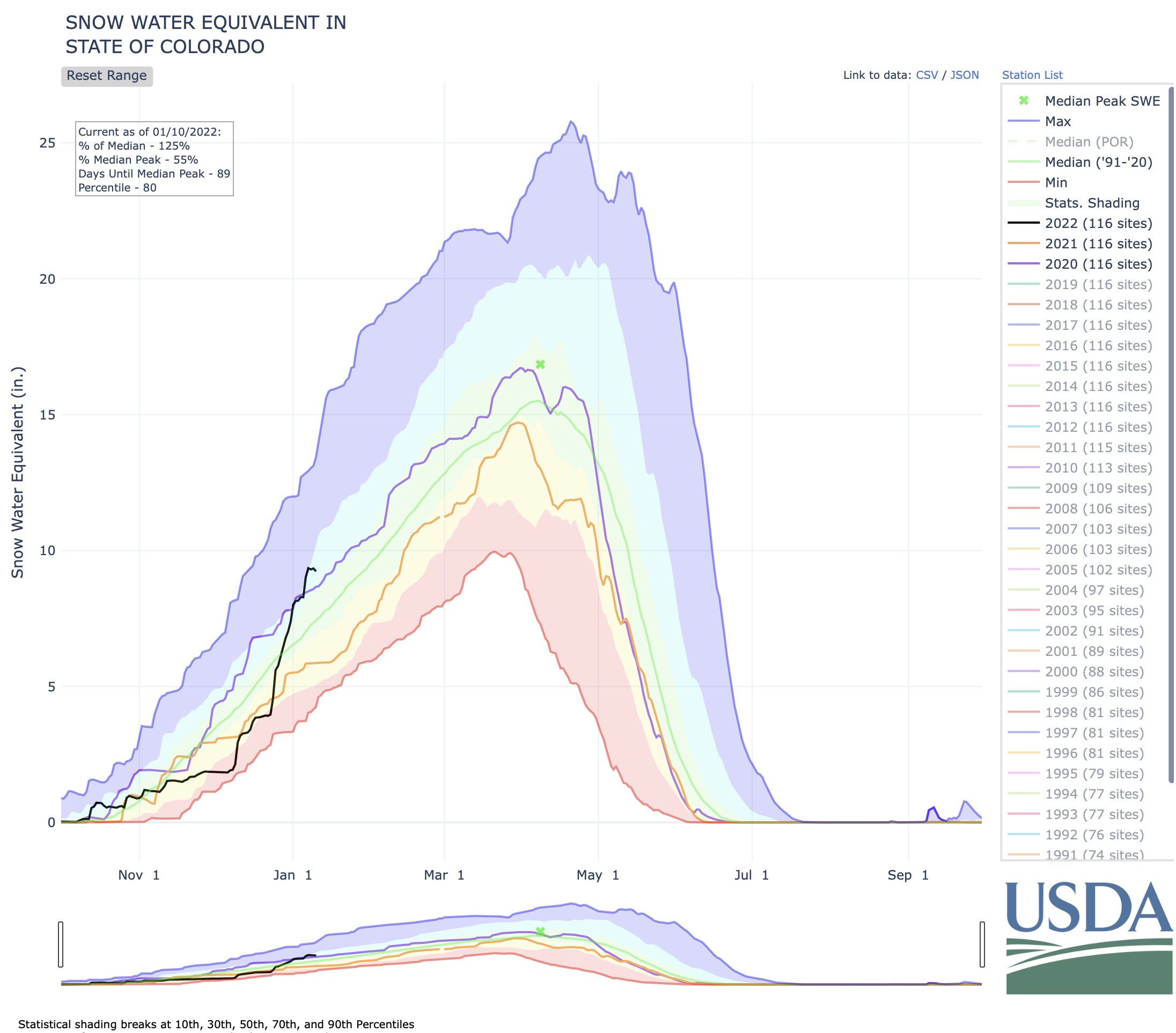
Colorado’s snowpack continues to break away from the 20-year to-date median, with 48 inches of snow falling in some parts of the state this week and more snow on the way.
Colorado’s current statewide snowpack is at 130 percent of the to-date median, as of January 7. This compares to the state being at 51 percent of the to-date median snowpack a month ago, on December 7.
A look at how radical this jump has been can be seen on the chart below, with the black line representing the snow water equivalent this year and the green line representing the 20-year median. The steep vertical climb of the black line shows how rapidly snow has been falling.
Let’s take a look a how each river basin varies by percent of to-date median snowpack…
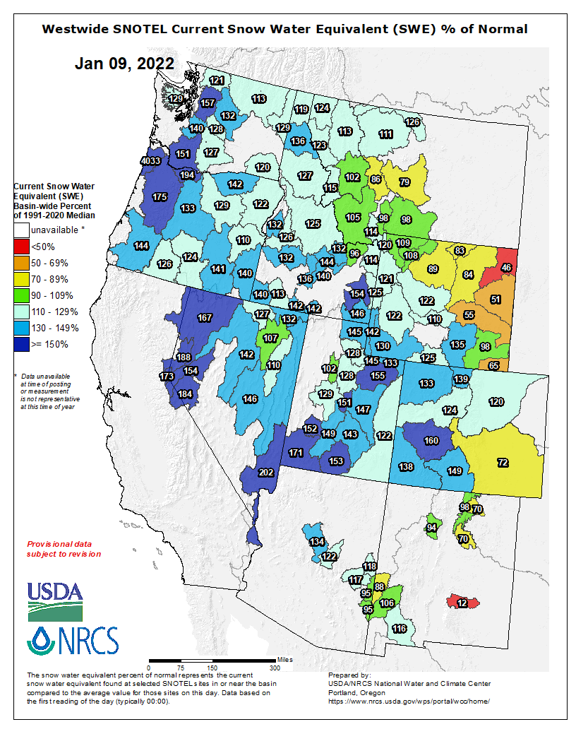
Colorado snowpack basin-filled map January 10, 2022 via the NRCS.
Arkansas River Basin: 98 percent
Colorado Headwaters River Basin: 132 percent
Gunnison River Basin: 148 percent
Laramie–North Platte River Basin: 145 percent
Upper Rio Grande River Basin: 97 percent
San Miguel–Dolores–Animas–San Juan River Basin: 135 percent
South Platte River Basin: 136 percent
Yampa–White–Little Snake River Basin: 131 percent
Colorado Drought Monitor map January 4, 2022.
Considering that 95 percent of the state was experiencing drought, as of January 4, we’ll take all the snow we can get.
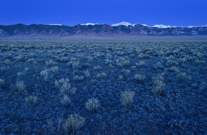
The country’s second largest potato producing region, is in its 18th year of drought in 2020. The San Luis Valley in Colorado is known for its agriculture yet only has 6-7 inches of rainfall per year. San Luis Valley via National Geographic
RWR’s proposal to Douglas County is, for an initial payment of $20 million, to build a pipeline that would bring 22,000 acre-feet of water from the San Luis Valley aquifer to the Front Range. If Douglas County agrees, the $20 million would come from ARPS stimulus money.
Struggling with water scarcity, changing climate, and aquifer depletion, San Luis Valley residents object to the proposal. A formidable group has organized around the belief that there is no water available to move outside the San Luis Valley.
Protect Our Water–San Luis Valley lists as members: 15 local water districts and entities; 22 cities and towns; 22 conservation and environmental groups; and two farm groups. On its website local governments in opposition to RWR’s proposal include the Rio Grande Water Conservation District and the Towns of Crestone and Saguache.
Despite their marketing assertions, RWR’s plan to export water from the San Luis Valley was not devised by locals nor will it benefit the entire valley.
RWR needs to find a customer like Douglas County to move its proposal forward. The plan relies on drawing water from the Upper Rio Grande Basin and exporting it to the Front Range. Without an identified end user for the exportation and sale of the water, RWR can’t file its plan in Colorado Water Court.
While the project has been in the works for some time, many questions remain unanswered.
RWR does not own municipal water rights, and RWR would need to buy wells and well rights before filing in court to convert irrigation water rights to municipal water rights.
Until recently, RWR executives asserted specifics about project locations, timetables, or costs were uncertain because they are focused on winning valley support and filing a legal case in Colorado’s water court, which could take three to five years to process. That case would help determine whether the San Luis Valley has enough water for RWR to legally export without hurting existing users.
In general, the proposal before Douglas County Commissioners reveals that RWR would build a wellfield northeast of Moffat. A pipeline would carry water north along state Highway 17, more than 1,000 feet up and over Poncha Pass to two access points along the South Platte River Basin, one at Antero Reservoir and another Elevenmile Reservoir, both in Park County.
In addition, a $50 million “community fund” would be developed under the RWR proposal to assist local communities with schools, broadband or food banks, senior services or job training. A separate pool of money, about $68 million, would pay farmers and ranchers who agree to sell their water rights, known in agriculture circles as “buy and dry.”
Those dollars will come from long-time private investors, according to Sean Duffy, a spokesman for RWR.
An agreement using stimulus money would give Douglas County access to needed water at less than half the typical rate of $40,000 to $50,000 per acre-foot, said RWR spokesman Sean Duffy…
Duffy also pointed out that both the water and economic status quo in the valley are not currently sustainable. Critics say the RWR project will only make the situation worse, while supporters argue it offers a more sustainable solution to the state’s water woes.
The San Luis Valley is described as one of the most arid regions in Colorado, receiving less than 9 inches of precipitation annually. In recent years snowfall on the Sangre de Cristos has been perceptibly less, resulting in reduced stream flows and reduced recharge of the two aquifers below the valley floor.
The shallow unconfined aquifer has been tapped with wells for crop irrigation for several generations and is over-appropriated. Below lies the confined aquifer which Renewable Water Resources believes holds a billion-acre foot of water.
That one-billion-acre foot estimate is highly disputed by local water managers, farmers and ranchers.
San Luis Valley Groundwater
Since 2012 many farms and ranches in the valley have already made self-imposed cuts in irrigation to try and prevent further depletion of the shallow aquifer. A number of subdistricts have been formed as local farmers’ only way of buying more time to solve depletions to the aquifer in their own way. Each subdistrict has until 2031 to replenish water to a predetermined level. Failure to meet those targets could result in the State Engineer’s office shutting down wells until the aquifer reaches that target through unimpeded recharge with no groundwater pumping.
RWR’s proposal is offering very similar benefits to those proposed by Stockman’s Water in 1998, a project that ultimately failed.
Stockman’s Water proposed to export at least 100,000 acrefeet annually, mitigating any water losses by offering, in exchange, 25,000 to 50,000 acre-feet of senior water rights.
Gary Boyce, the manager/ owner of Stockman’s Water, also promised a $3 million trust fund to be administered by Saguache County, and environmental benefits—more riparian and wetland habitat. Renewable Water Resources offers the potential opportunity to add over 3,000 acres to the Baca Wildlife Refuge located off of County Road T.
Cleave Simpson has met with the Douglas County Commissioners. Using federal American Rescue Plan Act funds for the RWR proposal is a twist he didn’t see coming.
“I think it’s unconscionable to use those federal dollars to diminish one community in support of another community,” he said. In addition to representing the San Luis Valley in the Colorado Senate, Simpson is the general manager of the Rio Grande Water Conservation District, which is leading the opposition to the RWR plan.
Simpson reminds us that there is a long history of legal fights over water export claims in the San Luis Valley. The Rio Grande Water Conservancy District already had money set aside to challenge the RWR proposal after the court awarded valley residents legal fees from a previous failed export case involving a developer in the 1970s, called American Water Development Incorporated.
The U.S. Bureau of Reclamation announced Friday that it plans to adjust management protocols for the Colorado River in early 2022 to reduce monthly releases from Lake Powell in an effort to keep the reservoir from dropping further below 2021’s historic lows.
As of Thursday, the nation’s second-largest reservoir — part of a Colorado River system that provides drinking water to approximately 40 million people throughout the West — sat at an elevation of 3,536 feet. That’s 27% of the reservoir’s capacity, 164 feet below full and just 11 feet above the bureau’s target elevation of 3,525 feet, designed to give a 35-foot buffer before “dead pool.” Below 3,490 feet of elevation, Lake Powell dips into a zone where the generation of hydropower by water flowing through the Glen Canyon Dam becomes unreliable.
According to a bureau news release, the modified delivery schedule will not alter the total amount of water let through Glen Canyon Dam over the course of the year but will hold back a cumulative 350,000 acre-feet between January and April to help Lake Powell recover from lows that left many boat ramps unusable at the popular recreation site last summer.
Despite a wet October giving water managers hope that the region might make some progress towards recovery amidst a 22-year drought, this past November was the second-driest on record and inflows came up 1.5 million acre-feet short of the Bureau’s projections from the previous month. When adjusted December projections anticipated Lake Powell dropping below 3,525 feet as soon as this February, the agency convened partners from the basin states, Tribes, federal agencies, non-governmental organizations and water managers to devise a new management scheme…
Scientists, however, are not sure spring runoff will materialize. In the 22nd year of regional drought, the term “aridification” is gaining traction as the better way to describe what might be a long-term drying of the American West, influenced by climate change.
“We need to be extra vigilant and careful, because we do not know what lies ahead,” said Jack Schmidt, director of Utah State University’s Center for Colorado River Studies in response to Friday’s announcement. “Looking into the future, none of us can know precisely what’s going to happen this year. We have had times when we’ve looked great at the end of February, and then had an exceptionally dry March and the snowpack evaporated.”
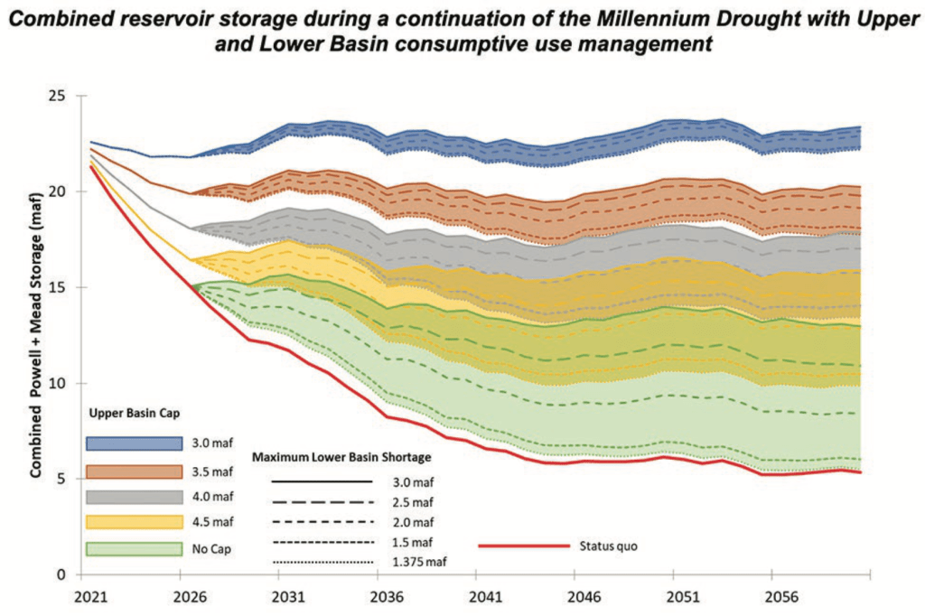
Schmidt was the senior author of a white paper published by a group of hydrologists last February that analyzed the future of Colorado River flows under various climate change and use scenarios. Their findings predicted that, given drying trends and a growing western population, projected basin-wide rates of water consumption could result in Lake Mead or Lake Powell running dry as soon as 2050, halting hydropower operations and negatively impacting the Grand Canyon ecosystem.
[…]
Figure ES-3. End-of-year combined Lake Powell + Lake Mead storage using hydrologic conditions sampled from the Millennium Drought (2000-2018) demonstrates the effects of a range of Upper Basin demand ‘caps’ along with a range of Lower Basin maximum shortages triggered when the combined storage falls below 15 maf. The status quo uses the 2007 UCRC Upper Basin schedule and elevation-based shortage triggers. Credit: The Center for Colorado River Studies
Wayne Pullan, regional director of the bureau’s Upper Colorado Basin, agreed [January 7, 2022] that there is uncertainty in the system…
In response to this, the agency plans to continue to monitor the basin’s hydrology and may make further adjustments to protect Lake Powell’s elevation. These could include sending additional water downstream to the reservoir from Colorado River Storage Project units at Flaming Gorge, Blue Mesa and Navajo reservoirs. Bureau officials will also continue to work with Upper Basin states on a Drought Response Operations Plan, due out in April 2022.
Schmidt, meanwhile, sees three shades of a silver lining to Friday’s doomsday-seeming announcement from the Bureau.
First, his team in February concluded that estimates of future consumptive use calculated by the Upper Colorado River Commission may be overinflated, giving the seven states that rely on this supply some additional wiggle room. If the western states learn to better live within their water means, their populations can grow without tanking the Colorado River system, they argue.
The second point, towards this end and also outlined in the February white paper, is that opportunities to stretch the supply further by improving water conservation efforts still abound. This is an argument often made by environmental groups critical of per capita water use rates in Utah’s Washington County which, by many measures, far exceed those in other similar desert communities…
Schmidt’s third note of positivity in reaction to Friday’s announcement from the Bureau is that the modified release schedule for Lake Powell actually better mirrors the natural flows of the Colorado River. Ecologists are often critical of the impact dams have on riparian environments. If we’re dealing with a situation of diminished overall flows, Schmidt says, it makes sense for artificial releases to be especially reduced in winter months when the river is lowest in its natural state.
Here’s the release from the Bureau of Reclamation (Elizabeth Smith):
The Bureau of Reclamation released a draft environmental assessment to supplement a final environmental impact statement (FEIS) completed in 2013 for proposed changes associated with construction and operation of the Arkansas Valley Conduit (AVC).
“Reclamation released an AVC Supplemental Information Report, in June 2021, that identified proposed changes in the AVC footprint, AVC participants, and a three-party contract with the Southeastern Colorado Water Conservancy District (Southeastern) and Pueblo Water,” said Reclamation Eastern Colorado Area Manager, Jeffrey Rieker. “This draft environmental assessment provides the supplemental analysis of the information in that report.”
Arkansas Valley Conduit map via the Southeastern Colorado Water Conservancy District (Chris Woodka) June 2021.
Reclamation would construct the AVC trunkline and Southeastern while AVC participants and others would construct AVC spur and delivery pipelines under the Proposed Action. The AVC project would utilize Pueblo Water’s existing system to treat and deliver AVC water from Pueblo Reservoir to a connection point east of the City of Pueblo along U.S. Highway 50, and eliminate 24.7 miles of pipeline construction around the city of Pueblo that was originally included the FEIS’s selected alternative.
The three-party contract will address AVC’s use of Pueblo Water’s water treatment plant and water delivery system, as well as Pueblo Water’s continued use of excess capacity storage in Pueblo Reservoir. The contract also incorporates the storage of additional water rights associated with the Bessemer Ditch and will replace an existing 25-year excess capacity contract that expires in 2025.
The environmental assessment has been prepared in compliance with the National Environmental Policy Act and is available for public review and comment at: https://www.usbr.gov/gp/ecao/avc/. The 2013 AVC FEIS, 2014 AVC Record of Decision, and 2021 AVC Supplemental Information Report can also be accessed from this webpage. Reclamation is requesting that any comments on the draft environmental assessment be submitted by January 30, 2022. Comments can be sent to tstroh@usbr.gov. For additional information, please contact Terence Stroh, Environmental Specialist, at 970-461-5469 or the above email address.
AVC is and authorized feature for the Fryingpan-Arkansas Project in Southeastern Colorado in Pueblo, Crowley, Otero, Bent, Prowers and Kiowa Counties. You can find more information on the Fryingpan-Arkansas Project at: https://www.usbr.gov/projects.