So this is what climate change looks like: operating on the margins, yet able to dramatically alter the story on center stage.
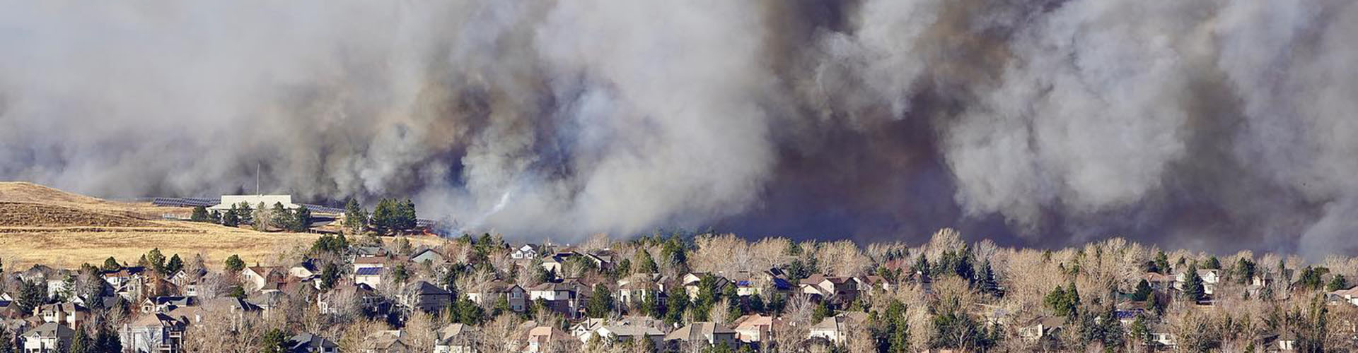
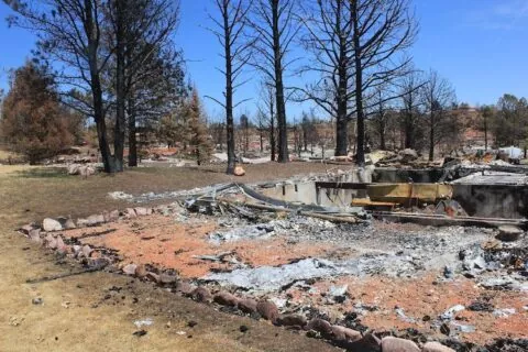
Warming temperatures played a monster role in creating the conditions that enabled the fire that burned nearly 1,000 houses as well as other buildings in Boulder County on Dec. 30.
“We are just numb. It happened so quickly,” Lafayette resident Peggy Williams reported in a Facebook post after being forced to flee. “We never thought our little towns would experience something like this.”
To understand what happened and why, it’s useful to examine the discrete elements. Some are entirely natural and nothing new. Taken together, though, they represent a new dynamic, unprecedented in Colorado.
“Certainly, climate change is never the only part of the story when it comes to wildfires. It’s part of the story but there’s always more to the story,” said Russ Schumacher, the Colorado state climatologist. “That being said, what we see in these fires and have seen in the last couple of years in Colorado, the changing climate is kind of making us expand our imaginations of what types of destructive wildfires are possible.”
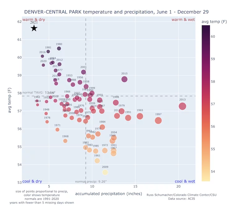
A scattergram assembled by Schumacher showing weather and precipitation records from three Front Range locations tells the story of hot and dry over past decades. The Fort Collins record goes back longer, but records kept at Denver’s Central Park – the site of Denver’s airport prior to DIA — are more proximate to Boulder.
The year 2021, for the period between June 1 and Dec. 29, stands alone in its intense combination of warm and dry, even compared to other seven-month periods. Look at the warm and dry quadrant closely and you will see a pattern: disproportionate representation of 21st century years.
Again, it’s not just precipitation, not just warmth. It’s the combination.
Because of the warm temperatures and drought, vegetation became bone dry by year’s end. And that resulted in what one meteorologist suspects was near-record combustibility of the grasses in the open spaces.
High winds were another crucial ingredient. They rapidly pushed the flames eastward from origins of the fire near Marshall, on the outskirts of Boulder, through Superior and into Louisville while threatening Lafayette, Westminster, and Broomfield.
What’s new in all this?
Wind? Absolutely not. Boulder, Golden, and Denver were still new mining supply camps in the 1860s, when the newspapers of Colorado reported the “savage violence” of winds that tore off roofs and stopped trains. Papers issued by researchers from the National Center for Atmospheric Research and the National Oceanic and Atmospheric Administration in the 1970s and 1980s reported winds in excess of 100 mph, including one gust of 137 mph at the NCAR building in January 1982.
The winds of Dec. 30 were notably strong but not without precedent. They shattered the glass in cars and other vehicles, but wind storms in the past have flattened buildings in Boulder, Golden, and other towns even in recent years.
No particular study of the winds seems to have been conducted since the 1980s, but the perception is that they have actually become less frequent in recent decades, according to Schumacher.
One final ingredient, what meteorologist and science writer Bob Henson calls the “other elephant in the room,” is housing and other buildings adjoining open spaces in Superior and Louisville. Without it, this would have been a prairie fire.
Conditions for the fire began setting up in spring. Abundant May rains created a landscape lush and green. Then in June, it stopped raining across most of the Front Range and temperatures spiked.
In a tweet, Henson pointed to records for Sept. 1 through Dec. 30 for Denver.
Temperatures an average 52.2 degrees Fahrenheit, the second warmest in 150 years.
Precipitation of 0.47 inch, the least in 150 years.
Snowfall of just 0.3 inch, the least in 140 years.
“The warmer it gets, the harsher these droughts will be on the landscape,” Henson, whose books include “The Thinking Person’s Guide to Climate Change,” wrote in the tweet.
The climate writing was on the wall
Climate scientists in recent years have stressed how rising temperatures can create drought where none would otherwise exist. These are called hot droughts, and California has made them infamous.
That expression has also been used in the Colorado River Basin. There, increased evaporation and transpiration caused by rising temperatures has robbed average or near-average snowpacks, producing runoff into Lake Powell of 25% to 30% of average.
In Boulder County, precipitation was nowhere near normal. In its New Year’s Eve story, “How extreme climate conditions fueled unprecedented Colorado fire,” The Washington Post reported that Boulder averages over 30 inches of snow between September and December; this year it got 1.46 inches.
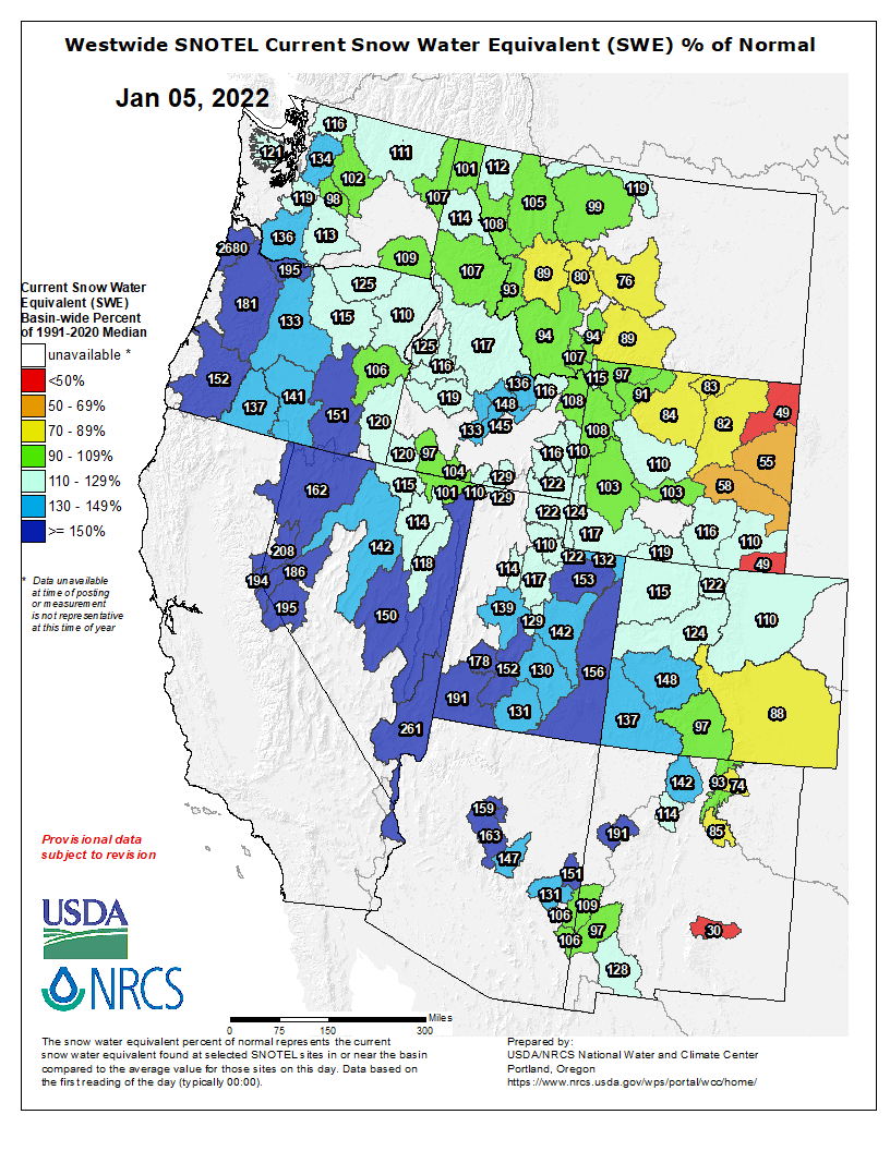
Graphic credit: Westwide Drought Tracker
This converted the green vegetation of May into the sort of tinder useful to getting the logs burning in the fireplace. The Washington Post story by staff writer and meteorologist Jason Samenow, assistant Colorado state climatologist Becky Bolinger, and meteorology student Jacob Feuerstein pointed to two indexes that document this flammability.
One, the Evaporative Demand Drought Index, or EDDI was at a record high in eastern Colorado during December. The index provides a snapshot of how “thirsty” the atmosphere is compared to normal that time of year.
“It can be a good wildfire risk predictor as it takes into account temperatures, sunlight and wind, in addition to humidity,” the authors wrote.
Another indicator, the Energy Release Component, was also dangerously high, reflecting the contribution of all live and dead fuels to potential fire intensity.
Boulder County had instituted fire restrictions on Nov. 30, prohibiting open fires, including charcoal barbecues and grills. The release said the restrictions were a response to the “increasing fire danger, lack of moisture, and the forecast for above seasonal temperatures without precipitation.” As of Dec. 30, eastern Boulder County was in a swath described by the Colorado Drought Monitor as “extreme,” the second driest category.
Then came the spark or fire – from a source or sources still undetermined as of Sunday evening — and the 6,200-acre conflagration.
Henson observes that the vast majority of the homes were built in the 1980s or later. Had this firestorm occurred 50 years ago, it might well have been largely a prairie fire. With the development, though, it became a different, more destructive fire.
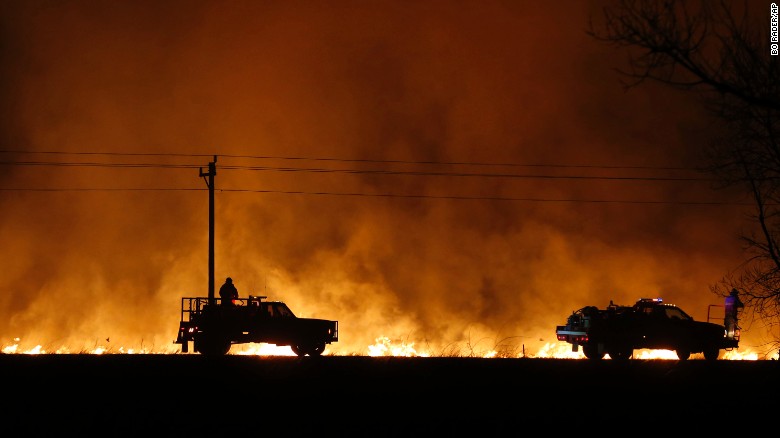
Firefighters from across Kansas and Oklahoma battle a wildfire near Protection, Kan., Monday, March 6, 2017. (Bo Rader/The Wichita Eagle via AP)
‘Several things going wrong at the same time’
Massive fires have not been uncommon on the Great Plains. In March 2012, a fire near Yuma burned 24,000 acres. Other fires in recent years have swept across hundreds of thousands of acres in other Great Plains states.
“As white cells are to man, so fire is to prairie,” wrote William Least Heat-Moon in “PrairyErth,” his paean to Chase County, Kansas. In his assessment of the tallgrass prairie, however, he did not speak to the seasonality of prairie fires.
The latest major fire on the Great Plains occurred in mid-December. A fire driven by gusts of up to 100 mph resulted in deaths of two men and damages across 163,000 acres near the town of Paradise in north-central Kansas. As with the Boulder County fires, abnormally dry conditions were blamed along with the winds.
“It was definitely a perfect storm,” Shawna Hartman, a spokeswoman for the Kansas Forest Service, told The Associated Press. “These fires ran for 20-plus miles in an afternoon. It’s very, very reminiscent of what you would see in California.”
In the shortgrass prairie of Boulder County, Henson described a similar confluence of “several things going wrong at the same time, including the wind storm, the dryness, the warmth drying out the landscape further.”
The suburban nature of this fire also deserves attention. This wasn’t the foothills in what is commonly called the wildland-urban interface. It was the place of winding streets, many million-dollar homes and an economy strongly engaged in northern Colorado’s booming high-tech economy.
Residents forced to flee were still in shock two and three days later, trying to sort out the circumstances that had at least one (and likely many others) shopping for clean underwear and other necessities at Target in nearby towns, still unable to return home.
That shopper, after a night deprived of sleep and still unsure of whether her rented home was standing — it was, but a house four doors away had become rubble — shared a friend’s report from afar of having a new understanding of what it’s like to be a refugee.
The Wildland-Urban Interface is the Boulder County suburbs
Daniel Swain, a climate scientist at the University of California Los Angeles and a well-known blogger, pointed out in a tweet that the Boulder County fires demonstrate “just how far into the suburbs the … interface actually extends given sufficiently extreme drought and wind conditions.”
In a tweet, the University of Montana’s Phil Higuera, a professor of fire ecology, also suggested the fires will “help dispel the misconception that the wildland-urban interface (#WUI) is ‘just’ a bunch of vacation homes in dense forest.”
In 2012, the Waldo Canyon Fire on the edge of Colorado Springs destroyed 346 homes and killed 2 people. Photo/Allen Best
During the last decade, fires have made it into the suburbs and exurbs. In 2012, the Waldo Canyon Fire destroyed 346 homes and killed 2 people on the northwestern outskirts of Colorado Springs. The next year, the Black Forest Fire destroyed 511 homes north in a forested area north of Colorado Springs in what was – until the Boulder County fires – the most destructive of human property in Colorado history.
Different from those June fires in and near Colorado Springs, the Boulder County fires occurred in late December. This is a new game, at least in Front Range fires. It’s also part of a trend: an expansion of wildfire season. Like tornados in Southern states and the Midwest, the calendar for wildfires is less useful.
Consider the East Troublesome Fire. In the 20th century, mid-October brought hunting season and snow. In 2020, it produced a new fire even as other fires, including the Cameron Peak Fire west of Fort Collins, continued to grow. Then came a wind storm and, on Oct. 22-23, East Troublesome raced past Grand Lake and vaulted across the treeless Continental Divide, forcing the evacuation of Estes Park.
Now comes the state’s biggest fire in history — on the cusp of New Year’s Eve.
The fire will force us to “expand our imaginations,” said Schumacher. “Thinking about the most destructive fire ever happening in late December is not the sort of thing that we were probably planning on. Given what we have seen in the last couple of years, we as a collective Colorado community need to do some rethinking of what is possible, what we need to prepare for.”
[…]
This story benefitted from editing by the crew at Boulder Reporting Lab. Scattergrams and posts courtesy of Russ Schumacher.
Click on a thumbnail graphic to view a gallery of drought data from the US Drought Monitor.
US Drought Monitor map January 4, 2022.
High Plains Drought Monitor map January 4, 2022.
West Drought Monitor map January 4, 2022.
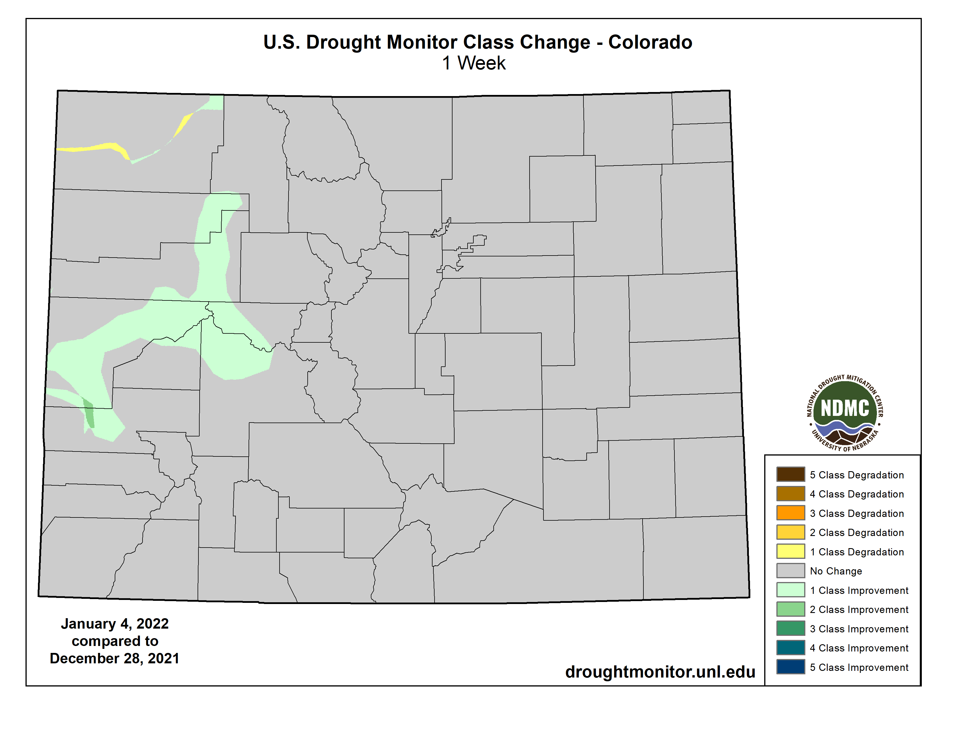
Colorado Drought Monitor map January 4, 2022.
Click here to go to the US Drought Monitor website. Here’s an excerpt:
This Week’s Drought Summary
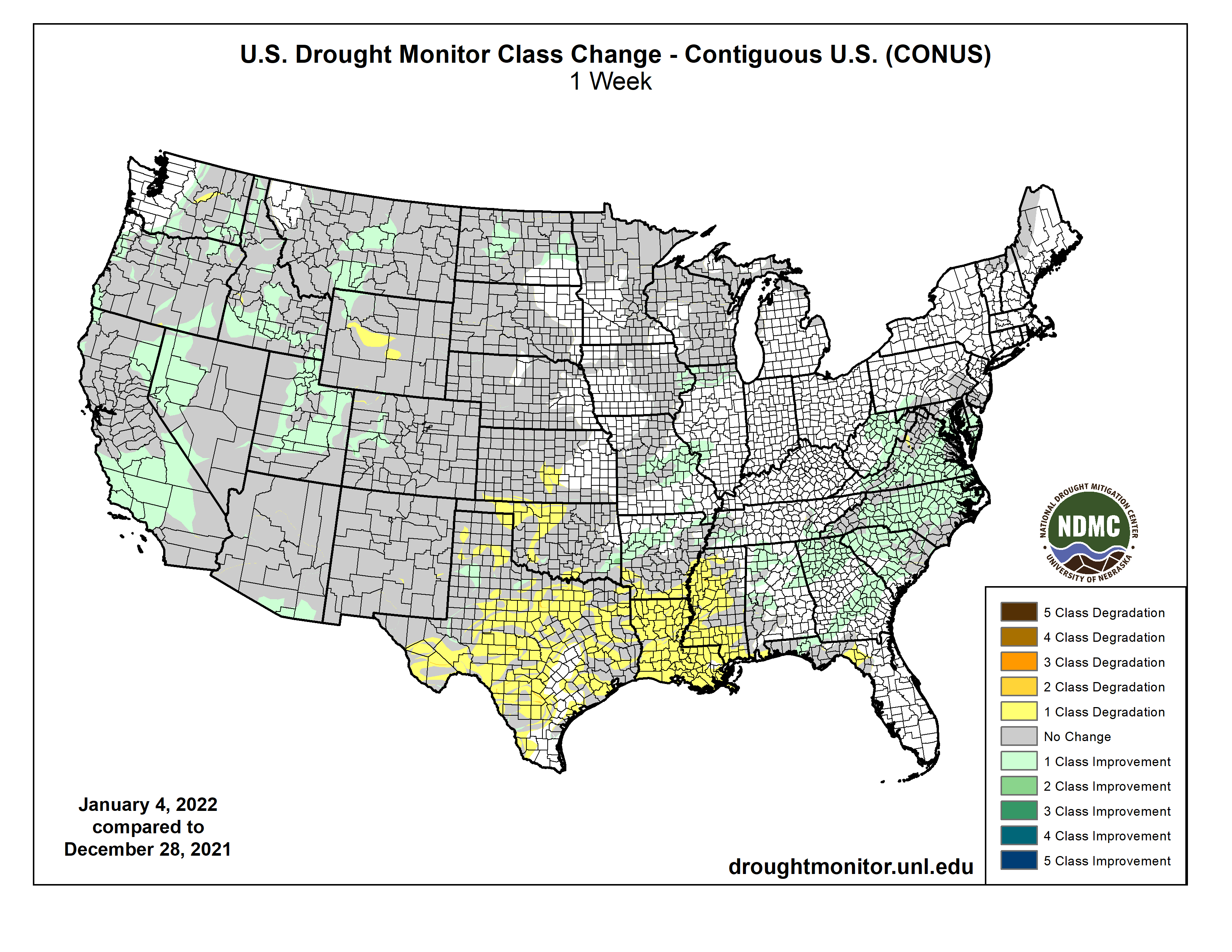
In what has become a familiar pattern, heavy precipitation continued to improve drought and dryness across the northern half of the West Coast States, though it created its own set of significant impacts. Farther south, similar totals fell on a relatively small area in southwest California. Heavy precipitation – some falling as heavy snow – also covered areas from the Ohio Valley and Middle Atlantic States southward through the Tennessee Valley, the interior Southeast, and the Carolinas. Parts of the Rockies – primarily the higher elevations – also reported moderate to heavy precipitation. Meanwhile, only light precipitation fell on the Northeast, across much of the lower Midwest, and along most of the Gulf Coast and adjacent areas. Most of the Plains and upper Mississippi Valley reported little or no precipitation. The result was some significant areas of drought improvement across the Carolinas and interior Southeast, as well as parts of the West Coast States and Rockies. In contrast, unseasonably warm and dry weather for several weeks prompted fairly broad areas of deterioration along the immediate central Gulf Coast, the southwestern half of the lower Mississippi Valley, and the southern Plains…
It was a dry week east of the Rockies, and even across Colorado and Wyoming, moderate to heavy precipitation was limited to the higher elevations. This was sufficient to prompt some improvement in western Colorado and a small section in northwestern Wyoming. The eastern portions of D0 and D1 areas in North Dakota were also improved based on a re-assessment of reduced impacts from earlier precipitation. Meanwhile, southern Kansas saw some deterioration near Oklahoma, where the last 60 days brought very little precipitation. But given it is the coldest and climatologically driest time of year there, deterioration was limited to a patch in the southernmost reaches of Kansas where the weather has been somewhat warmer. Central Wyoming also saw worsening conditions where little or no precipitation fell during the last 60 days…
Colorado Drought Monitor one week change map ending January 4, 2022.
Heavy precipitation and a generous snowpack in mountainous areas led to more improvement here, based in part on monthly statistics for December. Improvement was brought into large swaths of the region, especially across central Montana, much of Idaho and Utah, western Nevada, and part of central and southern California. It was a wet week with 2 to locally 6 inches of precipitation reported from the Cascades westward to the Coast in the Pacific Northwest and adjacent parts of California, further reducing dryness and drought in areas where such conditions have already been removed. Some areas in California already received more precipitation in the last 3 months than they had in the prior 12 months…
Eastern Tennessee – as with adjacent parts of the Southeast Region – reported at least 3 inches of rain, with as much as 6 inches in isolated spots. Farther west, less-widespread 2 to 4 inch amounts extended across northern Arkansas and adjacent Oklahoma. As a result, improvement occurred in many esixting areas of D0, keeping most of the northern tier of this Region drought-free and limiting D0 to some areas near the Mississippi-Ohio Rivers confluence, and interior eastern Tennessee. In stark contrast, several weeks of unseasonably warm weather and aubnormal precipitation led to broad deteriorations across the southern half of the Region from Mississippi and Louisiana westward through significant portions of Texas. Over the last 2 months, precipitation totals were 4 to 8 inches below normal from eastern Teas through Louisiana into central Mississippi, leading to widespread D1 to and D2 across central Mississippi, northern Louisiana, and eastern Texas while D0 expanded southward to cover areas from central Louisiana and Mississippi all the way to the Gulf Coast. Farther west across central and western portions of Texas and Oklahoma, deterioration was not as widespread and there were some small scattered areas of improvement, However, most of central and western Texas, the Texas and Oklahoma Panhandles, and central Oklahoma recorded 25 percent of normal precipitation or less for the past 60 days…
Looking Ahead
January 5-9, 2022 could benefit some of the recently-expanded areas of dryness and drought near the Gulf Coast. 0.5 to 1.0 inch is forecast along the Coast from the western Florida Panhandle through most of southeastern Louisiana, with amounts potentially topping 1.5 inches farther west into the northeastern Texas Coast. Farther north, moderate to heavy precipitation – including some substantial snowfall – should reach from the Lower Mississippi Valley through the upper Southeast, the central and southern Appalachians, and (to a lesser extent) the Middle Atlantic States. Between 1.5 and 2.5 inches of precipitation will impact a swath extending from northeastern parts of the Lower Mississippi Valley eastward into the southern Appalachians. Moderate precipitation should extend as far north as the immediate Ohio Valley, as far east as the Middle Atlantic Coast, and as far southeast as non-coastal areas of the Carolinas and Georgia. Heavy precipitation and some heavy snows should continue to whittle away at dryness and drought in the Pacific Northwest, although it will probably bring a different set of problems. Areas west of the Washington Cascades will be most significantly impacted, with most locations recording several inches (liquid equivalent) of precipitation. Several areas extending from the Idaho Panhandle and adjacent areas southeastward into central Colorado will also see moderate precipitation, especially in the Idaho Panhandle (1.5 to locally 3.5 inches) and higher elevations in Wyoming and Colordao. Other parts of the 48-states will see much less precipitation. Light to moderate precipitation (generally 0.5 to 1.0 inch) is expected across the Northeast, with little or none falling along the Southeast Coast and most of Florida, the Plains, and the southwestern quarter of the Nation. Temperatures will remain well below normal from the Upper Midwest through most of Montana, averaging 9 to 15 deg. F below normal. Near-normal temperatures will cover the Northeast and Middle Atlantic States while unseasonable warmth prevails along the southern tier of the country and in the Four Corners Region.
The Climate Prediction Center’s 6-10 day outlook (valid Jan 10-15, 2022) favors subnormal precipitation across most of the 48-states, with odds favoring above-normal precipitation limited to a swath from the southern Rockies to the Lower Mississippi Valley. Meanwhile, above-normal temperatures are favored near the Gulf Coast (especially Florida), the Plains, most of the Rockies, and the immediate West Coast.
US Drought Monitor one week change map ending January 4, 2022.
Just for grins here’s a gallery of early January US Drought Monitor maps for the past few years.
As J.T. Shaver, a forester with the Colorado State Forest Service, strolls through the Hutchison Ranch, a legacy cattle farm in Salida, Colo., it’s what he doesn’t see that excites him most.
Last year, the trees here were so dense you couldn’t see more than 20 feet away. The 11,713-foot peak of Methodist Mountain was obscured by piñon-juniper trees. Now, the trunks are pleasantly spaced out, letting in beams of sunlight. The ground is scattered with wood chips and stumps, feeding a healthy new bed of grasses.
“This looks completely different than this time last year,” Shaver says. “I’m pleasantly surprised.”
The landscape’s evolution was the result of a weeks-long treatment organized by Shaver’s office to help this 5,800-person town prepare for wildfire. By thinning the dense thickets of trees, any fire that does reach the ranch shouldn’t burn hot and fast in the crown of the trees. Instead, it should run along the ground with less intensity, burning more naturally. “We’re mimicking the behavior of a wildfire that would have occurred prior to European settlement,” Shaver’s colleague, Josh Kuehn, explains.
Over the past decade, Chaffee County’s once sleepy population has steadily grown as people seek refuge from the busier Interstate 70 corridor. In 2017, county leaders convened a master planning process but were surprised to learn that residents’ No. 1 concern wasn’t small business sustainability or housing prices or even traffic. It was wildfire.
“We knew about the beetle kill epidemic and saw that our forests were in poor health,” says Kim Marquis, project and outreach coordinator for Envision Chaffee County. “The first step to growth planning was taking on our wildfire risk.”
At that point, Chaffee County had been spared from the intense fires ravaging the state in recent decades, although the 2019 Decker Fire would soon burn just two miles south of Salida. But residents had embraced the frightening reality that few places in Colorado are safe from fires. Climate change and the decades-long drought have been fueling bigger and more dangerous fires, leaving devastation up and down watersheds.
The county assembled stakeholders, including state foresters, federal officials, local landowners and farmers, to work proactively to improve forest health. Aurora Water also joined the talks, since a fire near Salida could potentially pollute the headwaters of the Arkansas River, one of Aurora’s primary water sources. The partners thoroughly mapped the area, highlighting the properties and forests most at risk if a fire did come through the Rio Grande and San Isabel National Forests.
While local landowners could take their own preventative measures like shoring up buildings and removing dead trees, the Colorado State Forest Service (CSFS) also received funding for a more holistic treatment. The Methodist Front Wildland Urban Interface Forest and Watershed Health Restoration Project, funded through a RESTORE Colorado Program grant, along with the U.S. Forest Service (USFS), Salida and Poncha Springs, and a county fund, will treat 478 acres of public and private land, masticating trees to thin out the crowns and encourage healthier vegetation. Eventually, with the participation of enough landowners, the fuel break will stretch five miles, creating a buffer between the forest and the ranches, townhomes and small farms in Salida.
How fires went from healthy to hazardous
Decker Fire October 2019. Photo credit: Greg Hobbs
The Decker Fire, which burned nearly 9,000 acres, came in an unusually calm year in the midst of a decade that has reshaped how Coloradans see fire. Since 2012, six megafires, defined by the National Interagency Fire Center as fires larger than 100,000 acres, have burned in Colorado.
Looking towards Boulder at the Marshall Fire December 30, 2021 From 53rd and Stuart in Adams County.
Last week, the Marshall Fire in Boulder County, though just a few thousand acres in size, became the state’s most destructive, burning nearly 1,000 homes in Superior, Louisville and parts of unincorporated Boulder County.
During 2020’s Pine Gulch Fire, north of Grand Junction, Colo., hotshot firefighters watch and wait for the fire to burn through brush and move to grass fields, where the flames become less intense, before they can hold it back. Photo by Kyle Miller/Wyoming Hotshots, USFS, via National Interagency Fire CenterA helicopter drops water on the Cameron Peak Fire near CSU’s Mountain Campus. Photo credit: Colorado State UniversityA view from the highway of the massive East Troublesome wildfire smoke cloud near Rocky Mountain National Park in Colorado on October 16, 2020. Photo credit: Inciweb
2020 saw the state’s three largest recorded fires to date—Cameron Peak, East Troublesome and Pine Gulch—and some 700,000 acres burned, more than 540,000 of which burned in those three fires alone. And the CSFS’s 2020 Forest Action Plan projects a 50% to 200% increase in the annual area burned in the state by 2050.
There’s no single factor making Rocky Mountain fires more intense. Bark beetle infestations swept through tens of millions of acres of forest in the West over the past two decades, leaving large stands of dead trees. A century of federal policy that squelched out all fires rather than letting them burn naturally led to a buildup of fuel stores in forests. Climate change is creating warmer and drier conditions, and an earlier snowmelt has extended the fire season.
Chuck Rhoades, a research biogeochemist at the USFS’s Rocky Mountain Research Station, says those “compound disturbances” have created a pattern of fires that are burning more intensely and in places and seasons that experts wouldn’t predict. Fires that once would have been a natural tool to clear dead fuel and encourage seeds to sprout are now a major threat to communities. Some, including Cameron Peak and East Troublesome, have ravaged high-elevation forests where fires used to be rare. A 2021 study in the Proceedings of the National Academy of Sciences found that high-elevation forests in the Rocky Mountain region are burning more than at any point in the past 2,000 years.
That, Rhoades says, means land managers and cities are seeing impacts outside the scope of anything they’ve prepared for—with ripple effects throughout the environment.
“We often think that where we were before will help us predict where we’re going,” he says. “But there are a lot of question marks out there. It forces a little humility in that we can’t understand what we’re going to get next.”
One known, however, is that the higher-intensity wildfires are putting more Coloradans at risk as the state’s population booms. In 2020, the CSFS estimated that half of the state’s population lived in Colorado’s 3.2 million-acre wildland-urban interface area, known as the WUI, where human development intermingles with fire-prone vegetation. By 2050, CSFS says that area could triple in size to encompass more than 9 million acres, or more than 13% of the state.
The risks are especially profound for watersheds. As more intense fires clear out thick older trees, shrubs and grasses grow back in their place. Without dense roots and pine needle cover, the forest floor that typically acts as a sponge for snowmelt and precipitation is turning fragile and rocky. Those are prime conditions for erosion and flooding, with streams and rivers accumulating water faster and earlier than usual. According to USFS research, the risk of flooding and debris flow is higher for at least 3-5 years post-fire, often longer, and those floods can be as much as three times more severe than they would be otherwise.
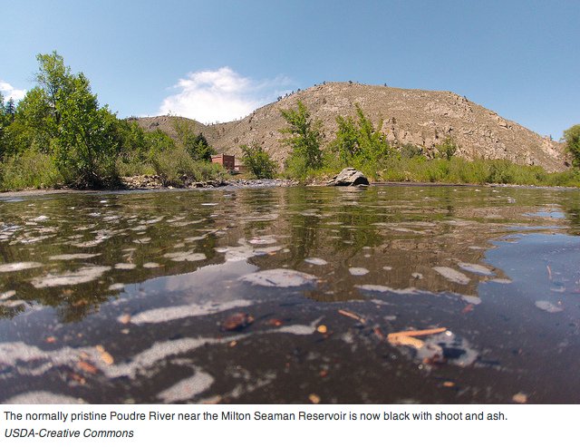
Ash and silt pollute the Cache la Poudre River after the High Park Fire September 2012
Runoff from burn scars can run black, laden with ash, debris, nutrients and heavy metals from burned soil and biomass. If those contaminants reach utilities’ water infrastructure, they can clog water filters or settle in reservoirs, possibly fostering algal blooms and taking up valuable reservoir space.
The 1996 Buffalo Creek Fire and the 2002 Hayman Fire, the largest in Colorado’s history until 2020, each burned along the Upper South Platte River, immediately upstream of Strontia Springs Reservoir, which accommodates about 80% of Denver Water’s raw water supply and 90% of Aurora’s supply. The fires exacerbated erosion in the watershed, leading to sediment-laden flows that dumped debris and contaminants in the reservoir. More than a decade later, the reservoir’s capacity to store water remains reduced, and water quality is still impacted from sediment flows, even after $27.7 million worth of dredging, removal and recovery work. Last year’s fires caused water utilities across the state to shift their operations to protect their source water.
It’s clear, then, that the risks of fires no longer stay in the forest. Partnerships have sprung up from Boulder to Durango to protect valuable watersheds and water infrastructure, forcing water district managers to become just as interested in what happens to the forest around headwaters as what goes into their customers’ pipes.
All hands on deck
In 2020, the Colorado State Forest Service released its updated Forest Action Plan, identifying some 2.5 million acres—roughly 10% of the state’s forests—as being “in urgent need of treatment.” The highest priority forests were in the Front Range’s Arapaho-Roosevelt and Pike-San Isabel forests and in the San Juan Forest around Durango. “We have to prioritize those areas where we’re going to get the most bang for the buck,” says Weston Toll, watershed program specialist for the CSFS. Still, he says, with so much of the state at risk, “we’re paddling against the current.”
The Forest Action Plan’s priority map reflected a range of factors, including where fuel had built up, how close fires could get to human development, and the impact on wildlife and water. But those areas didn’t all line up with valuable headwaters, despite some water managers’ arguments that any waterways must be protected. Nor does the map give much direction on how to square the widespread needs with limited resources.
Wildfire mitigation used to be defined by what some experts call “random acts of restoration,” individual projects on small plots of land depending on the owner’s interest and availability. A National Forest might have dead trees removed and fuel treated for insect infestation, but neighboring land might be left untreated, doing little for the overall region’s safety.
Now, the USFS and others are promoting a philosophy of shared stewardship, bringing together a variety of partners ranging from federal land managers, local water districts, utilities, logging companies, recreationists and private landowners to collaborate on responsible forest management.
Toll says the state may still be paddling against the current, but “it helps to have everyone paddling in the same direction, which wasn’t happening until five or 10 years ago.”
Watershed Assessment Vulnerability Evaluation (WAVE) volunteers work to install silt fencing immediately above Northern Water’s Willow Creek Reservoir. Photo by Emanuel Deleon, Colorado State University
‘Mutual benefits’
After the runoff from the Buffalo Creek and Hayman fires poured sediment into Strontia Springs Reservoir, officials at Denver Water realized they could be spending less money and having a bigger impact by focusing on preventing fires and flooding before the effects reached their infrastructure. The utility formed the From Forests to Faucets partnership with USFS, a multi-year effort to fund forest health projects to boost resilience in priority areas within Denver Water’s collection system. In 2017, the program was expanded to include state and local authorities to stretch Denver Water’s forest health work to non-federal lands.
Fuel breaks played an important role protecting homes during the Buffalo Fire on June 12, 2018, in Summit County. Photo credit: U.S. Forest Service.
Fuel breaks around the Dillon Reservoir watershed funded by the program are credited with protecting nearly 1,400 homes near Silverthorne during the 2018 Buffalo Fire, despite red-flag drought conditions.
“There was this exciting realization that there were a lot of mutual benefits in funding these projects,” says Madelene McDonald, watershed planner at Denver Water. “Forest restoration projects not only bolster source water protection, but also improve wildlife habitat, expand recreation access, and can protect communities in the wildland urban interface.”
But it is also incumbent on communities to do their own preparation. That can include building codes that require fire-resistant building material or defensible space requirements to clear fuel from some established perimeter around buildings. Colorado does not have a state wildfire code or model ordinance, despite recommendations from a 2014 task force, but communities like Boulder and Colorado Springs have regulations governing new homes in at-risk areas.
“There’s a big educational component, but seeing a disaster happening right in our faces prepares people,” says Marquis of Envision Chaffee County. “We’re asking people to join this honestly heroic story to protect the community.”
Money matters
Addressing all of the CSFS’ Forest Action Plan’s priority areas is estimated to cost $4.2 billion, money that state agencies and local partnerships just don’t have. USFS spent $1.8 billion in fire suppression, fighting and responding to wildfires nationally in fiscal year 2020, but just $431 million on treatments to reduce fuel buildup through its Hazardous Fuels program, according to national spokesperson Babete Anderson. According to National Interagency Fire Center data, other federal government programs spent $510 million on fire suppression in 2020. According to a Colorado Department of Public Safety report, Colorado’s 2020 fire season cost the state an estimated $38 million in suppression costs and required another $248 million in federal funds. Those state figures don’t include suppression costs footed by local agencies or the costs of property loss, infrastructure damage, watershed impacts, or economic losses. Nor do they account for other private, local, county or federal wildfire expenses.
The federal bipartisan infrastructure bill brings nearly $8 billion for wildfire risk reduction and forest restoration, including $90 million a year for the U.S. Department of Agriculture’s Landscape Restoration Partnership Initiative to support forest and grassland restoration secured by Colorado Sen. Michael Bennet.
Fire departments and forest managers can also cobble together money from grants from a variety of federal sources. In 2021, the Colorado legislature passed SB21-258, which authorized $25 million for wildfire mitigation, recovery and workforce development. In a statement, Colorado Department of Natural Resources director Dan Gibbs said the bill would “quickly move resources to on-the-ground projects and mitigation teams,” a step up from previous efforts that “have lacked the coordination, landscape-scale focus and robust state investment required to properly address the size and behavior of catastrophic wildfires.”
Even with those funding sources, it can be a challenge to prioritize spending in areas with the biggest benefit, or even address the widespread impacts of fires. Studies have shown that up-front mitigation saves costs on fire suppression, but even that is daunting when the needs are so vast.
Shaver, the Salida forester, says his community seems to understand that narrative and is on board with the cost of mitigation, knowing that the worst risk could be coming during any upcoming fire season.
“Sometimes there’s a feeling that you wish a fire would come through to validate the work,” Shaver says. “But a lot of people say they feel safer, and that in and of itself makes the work successful. Feeling safe is a win whether or not anything ever burns.”
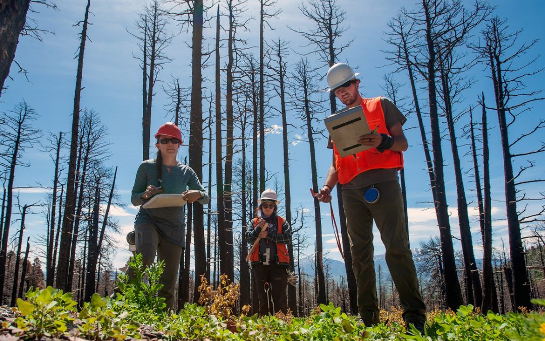
Camille Stevens-Rumann, a forestry researcher at Colorado State University, graduate assistant Zoe Schapira, and field technician Zane Dickson-Hunt gather data in 2019 at the 2018 Spring Creek Fire burn scar, near La Veta, Colo. Here, aspen and scrub oak have sprouted but all pine trees and cones were destroyed in the fire. Photo by Mike Sweeney
The megafire era gripping the West isn’t just a threat to human development. Fires now burn so intensely that they literally reshape forests, shift tree species, and turn calm waterways into devastating mudflows.
A 2017 University of Colorado study analyzing 15 burn scars left from fires in Colorado and New Mexico found that as many as 80% of the plots did not contain new seedlings. In a 2020 follow-up study project under different climate change scenarios, the most severe scenario, where climate change continues unabated through 2050, showed as many as 95% of ponderosa pine and Douglas fir forests would not recover after a fire. In a “moderate” scenario where emissions decline after 2040, more than 80% of the forest would be replaced by scrubby grassland.
That, said study author Kyle Rodman, could have serious implications for waterways, due to the lack of established trees to stabilize soil and reduce the risk of flooding.
“Just because there aren’t trees doesn’t mean there’s no vegetation. Grasses and shrubs can hold back the soil, but it won’t be the same,” says Rodman, now a postdoctoral research assistant at the University of Wisconsin.
Nearly two decades later, the site of the 138,000-acre Hayman Fire, which burned in an area southwest of Denver in 2002, is still marred with patches of bare ground. That fire, according to a U.S. Forest Service (USFS) study, was so severe in areas that it consumed the canopy foliage as well as the seed bank for the forest’s ponderosa pines and Douglas firs, limiting regeneration. Overall, the study predicted “gradual return to preferred conditions” in the Hayman Fire area, though some of the worst-hit patches may see permanent vegetation changes.
Slopes above Cheesman Reservoir after the Hayman fire photo credit Denver Water.
In lower elevations, some of the heartier species, like the ponderosa pine and Douglas fir, are having trouble regrowing because of the increased heat and months-long drought. A 2018 study found that even seedlings of those species that were given supplemental water in burned areas had lower survival rates than expected because of the harsh natural conditions.
“When you’re planting a garden, those first few days are so critical. The plants need water to establish their roots and get healthy,” Rodman says. “Trees work a much longer timescale. Those first few years should be cool and wet and we just don’t have those conditions too often.”
Some tree species, like the high-elevation lodgepole pine, generally rely on fire because the heat helps them open and release seeds. But recent fires are burning so intensely that even lodgepole cones are consumed.
A 2020 study in BioScience found that burned forests are showing “major vegetation shifts” and recovering more slowly than expected. In some cases, heartier species might give way to drier shrub-dominated vegetation that can burn more easily. The study found that, generally, those post-fire “forested areas will have climate and fire regimes more suited to drier forest types and non-forest vegetation.”
That means that hearty forests used to adapting to natural changes are now facing conditions “outside the realm of the disturbances that some forests can handle,” says lead author Jonathan Coop, a professor of environment and sustainability at Western Colorado University.
“We have this paradigm that fire is a natural part of the forest and that forests will always recover,” Coop adds. “These days, we shouldn’t count on that.”
That vegetation shift is especially worrisome for waterways. Normally, forest floors soak in rain and snowmelt, releasing it to waterways slowly throughout the spring and summer. Burn-scarred watersheds, however, have faster runoff and a lower water yield because of the loss of natural material and because of hydrocarbons from smoke permeating the soil. A USFS analysis found that more than 50% of wildfire-scarred land area in Colorado showed increased erosion potential, mudslide threats, and sediment in streams for at least 3-5 years after a fire.
Those effects can last even longer depending on natural conditions, says USFS research engineer Pete Robichaud. The wild seasonal swings from climate change are challenging forests by dumping more precipitation on less stable ground.
The aftermath of July 2021 floods in Poudre Canyon, west of Fort Collins. (Credit: Colorado Parks and Wildlife)
“The drought cycle is bigger and the wet cycle is more intense,” Robichaud says. “The perfect storm is a high-severity fire followed by a high-intensity rainfall event.”
The harsh natural conditions, as well as widespread damage from bark beetles, has complicated typical recovery efforts. Some scientists say the rapid changes in forest conditions and fire characteristics make it hard to know what the best recovery strategy is. In some forests, for example, aspen trees that regenerate from low-ground structures rather than relying on seeds to sprout may dominate. Especially in low-elevation areas, shrubbier species like the Gambel oak may regrow faster in forests once driven by conifers.
While replanting is a natural step in recovery (USFS hosts six national nurseries that act as seed banks, although it has restrictions on where certain species can be planted), there are even concerns that the natural conditions should prompt a re-examination of how best to revitalize forests. Ultimately, Coop says, we should expect that forests may not look the same as they did in a pre-megafire era.
“I think this points to the need for all stakeholders and the public to start to think outside the box as far as how we evaluate the forests and ecosystems we depend on,” says Coop. “We might have to think about what ecosystems we are saving and under what circumstances we’ll have to let things go and let some changes unfold.”
A version of this article was first published in the Headwaters magazine Fall 2021 issue.
Jason Plautz is a journalist based in Denver specializing in environmental policy. His writing has appeared in High Country News, Reveal, HuffPost, National Journal, and Undark, among other outlets.