Click on a thumbnail graphic to view a gallery of drought data from the US Drought Monitor.
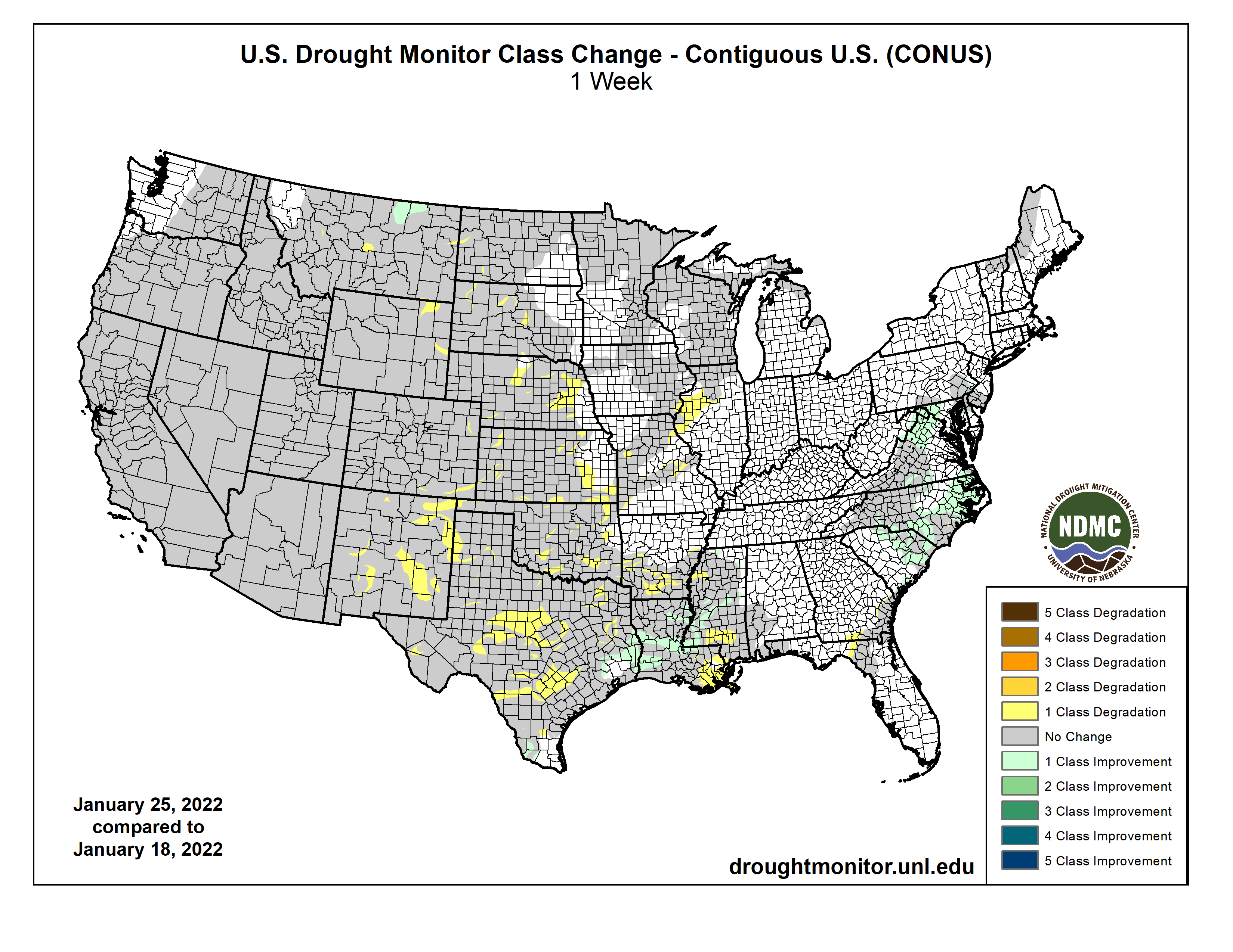
US Drought Monitor map January 25, 2022.
High Plains Drought Monitor map January 25, 2022.
West Drought Monitor map January 25, 2022.
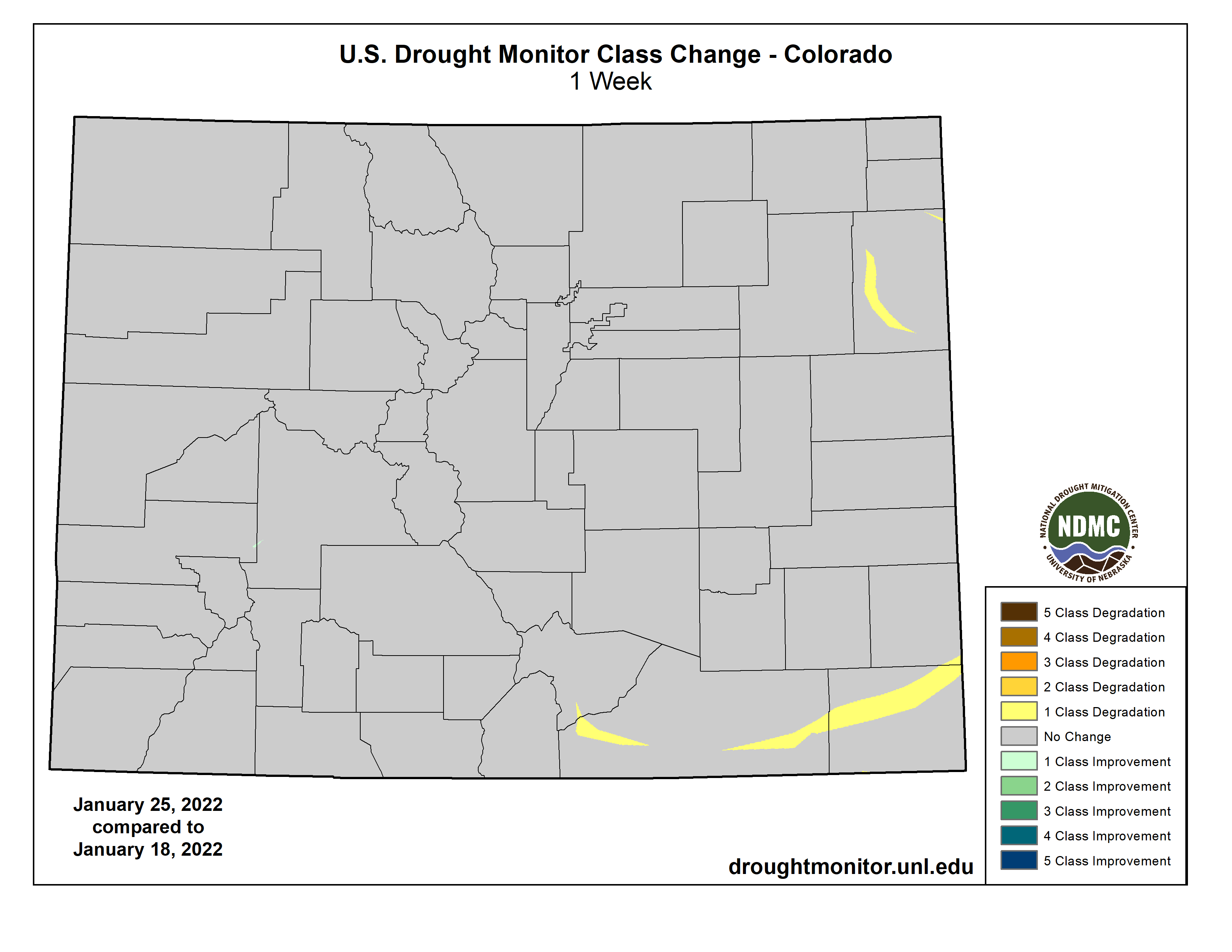
Drought monitor Colorado Drought Monitor map January 25, 2022.
Click here to go to the US Drought Monitor website. Here’s an excerpt:
This Week’s Drought Summary
As the drought-monitoring period began on January 18, a moisture-laden storm had just cleared the Atlantic Coast States. A few days later, another system delivered a variety of weather, including rain, freezing rain, sleet, and snow, across parts of the South. The latter storm produced significant snow on January 21-22 near the middle Atlantic Coast, including eastern North Carolina and southeastern Virginia. Most of the remainder of the country experienced a dry week, aside from periods of mostly light precipitation from the Pacific Northwest to the Great Lakes States. However, completely dry weather prevailed through January 24 in several areas, including California and the parched southern Plains, where 71 percent of Texas’ winter wheat was rated in very poor to poor condition. As the drought-monitoring period ended early January 25, some snow developed on the northern and central High Plains, while rain returned along and near the Gulf Coast. Elsewhere, frigid conditions from the Midwest into the Northeast and generally chilly conditions across the eastern half of the country contrasted with near- or above-normal temperatures farther west…
Despite some snow on the High Plains late in the drought-monitoring period, the general theme was toward gradually worsening drought conditions, especially in Kansas and Nebraska. U.S. Department of Agriculture statistics from January 23 reflected some of the issues being faced by farmers, with topsoil moisture rated at least one-half very short to short in Colorado (82%), Kansas (77%), Nebraska (73%), and Wyoming (60%). In addition, at least one-quarter of the winter wheat was rated very poor to poor on that date in Kansas (31%), Wyoming (33%), Colorado (40%). Even in the Dakotas, where some drought recovery has occurred in recent months, topsoil moisture was greater than 40% very short to short. In addition, stock water supplies in North Dakota were reported to be 50% very short to short…
Colorado Drought Monitor one week change map ending January 25, 2022.
Much of the region has experienced alternating periods of wet and dry weather since the Water Year began on October 1, 2021. For example, a wet October was followed by a warm, dry November; an exceptionally stormy December; and a mild, dry January. As the West moves into the second half of its winter wet season, a return to stormy weather will be needed to sustain the drought improvement that occurred during October and December. According to the California Department of Water Resources, the water equivalency of the Sierra Nevada snowpack increased less than an inch (from 15.4 to 16.0 inches) between December 30 and January 26, with the corresponding percent of average for the date falling from 160 to 103%. Compared to normal values, snow-water equivalency was appreciably lower (less than two-thirds of average in several river basins) across the eastern slopes of the Rockies, especially in eastern Wyoming and much of New Mexico, resulting is some drought deterioration. In New Mexico, topsoil moisture was rated 87% very short to short on January 23, according to the U.S. Department of Agriculture, while stock water supplies were 49% very short to short. With the recent dryness, compounded by long-term drought issues and warm, windy weather, a rare January wildfire—the 700-acre Colorado Fire—erupted near Big Sur, California, on January 21…
Locally heavy rain delivered some drought relief from southeastern Texas to central Mississippi, but largely bypassed other areas of the South. In fact, worsening drought conditions were noted across the southern Great Plains, including large sections of Oklahoma and Texas. Some of the most significant Southern rain fell on January 19-20, when totals approached, reached, or exceeded 2 inches in locations such as Houston, Texas (1.98 inches), and Vicksburg, Mississippi (2.06 inches). Additional rain fell across the Deep South on January 24-25. Farther north and west, however, drought broadly worsened, with exceptional drought (D4) expanding slightly in western Oklahoma. On January 23, according to the U.S. Department of Agriculture, topsoil moisture was rated 81% very short to short in Oklahoma and 64% very short to short in Texas. On the same date, winter wheat was rated 71% very poor to poor in Texas, along with 43% in Oklahoma. Just 3 months ago, in late-November 2021, those numbers stood at 45 and 16% very poor to poor, respectively. Worsening drought on the Plains has also contributed to several mid-winter wildfires; a few, including the Mill Creek Fire in Shackleford County, Texas—which was ignited on January 15—torched more than 1,000 acres of brush and grass. Burn bans were in effect for dozens of counties in Oklahoma and Texas…
Looking Ahead
During the next 5 days, the only major storm system to affect the country will develop near the southern Atlantic Coast and move northward. The potential exists for significant accumulations of wind-driven snow, starting Friday night and continuing into the weekend, from the middle Atlantic Coast into New England. Most of the remainder of the country will receive little or no precipitation, although exceptions during the next couple of days will include rain from southern Texas to Florida’s peninsula and snow squalls downwind of the Great Lakes. In addition, precipitation should begin to overspread the Northwest during the weekend. Elsewhere, frigid conditions will linger during the next several days from the Midwest into the Northeast, while areas as far south as Florida’s peninsula may experience sub-freezing temperatures as January draws to a close. The NWS 6- to 10-day outlook for February 1 – 5 calls for the likelihood of above-normal temperatures in the eastern U.S., while colder-than-normal conditions will prevail along and west of a line from central Texas to Lake Michigan. Meanwhile, below-normal precipitation in the Far West, including northern and central California and the Great Basin, should contrast with wetter-than-normal weather in most areas from the central and southern Rockies to the Atlantic Coast.
US Drought Monitor one week change map ending January 25, 2022.
Last week’s $90 million settlement relating to the 2015 Gold King Mine Blowout that turned the Animas and San Juan Rivers TANG-orange for over 100 miles downstream did not bring an end to the legal saga that has dragged on for more than six years (lawsuits against the federal government are still pending). But when the agreement is finalized, Sunnyside Gold Corp—the owner of the nearby, now-shuttered Sunnyside Mine—will finally be free of the mess. Extricating themselves from any further liabilities has cost them about $67.6 million: $40.5 million to the feds; $6.1 million to the State of Colorado; $11 million to the State of New Mexico; and $10 million to the Navajo Nation, not to mention the tens of millions they’d already spent cleaning up a century’s worth of mining mess.
In agreeing to the payments, Sunnyside and its parent company, Canada-based global mining giant Kinross, have made it clear that they are not admitting wrongdoing or liability. They don’t own the Gold King Mine and never did. So why did the company fork out so much money?
The simple answer is that the bulkheads Sunnyside installed in the American Tunnel in the 1990s and early 2000s caused water to back up inside Bonita Peak and make its way into the Gold King Mine, resulting in the 3 million-gallon blowout. The truth is a bit more complicated.
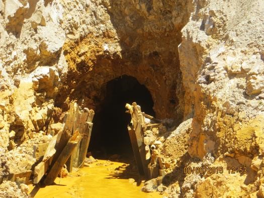
Bulkheads, like this one at the Red and Bonita Mine, help stop mine water discharges and allow engineers to monitor the mine pool. Credit: EPA.
The real question is not whether Sunnyside’s bulkheads backed up water into the Gold King Mine. That’s pretty much a given. More important is exactly where the water came from in the first place. And to get at that answer, we need to go back in time a century and some to the days when the Gold King Mine was one of the most profitable operations in Colorado.
To see the photos in full resolution, please view this at http://LandDesk.org.
A Timeline of the American Tunnel
1887 Olaf Arvid Nelson, while working at the nearby Sampson Mine, surreptitiously locates the original Gold King claim on the slopes of Bonita Peak, and goes to work on it immediately. He eventually digs a 50-foot shaft and a 50-foot drift, but never makes money from it.
1891 Nelson dies, perhaps from pneumonia, silicosis or just overwork. A year later his widow, Louisa, patents the Gold King claim, taking title to it. And in 1894 Louisa sells the Gold King claim to Northeastern capitalists Cyrus W. Davis and Henry Soule, for a mere $15,000. They hire local Willis Z. Kinney to run the mine.
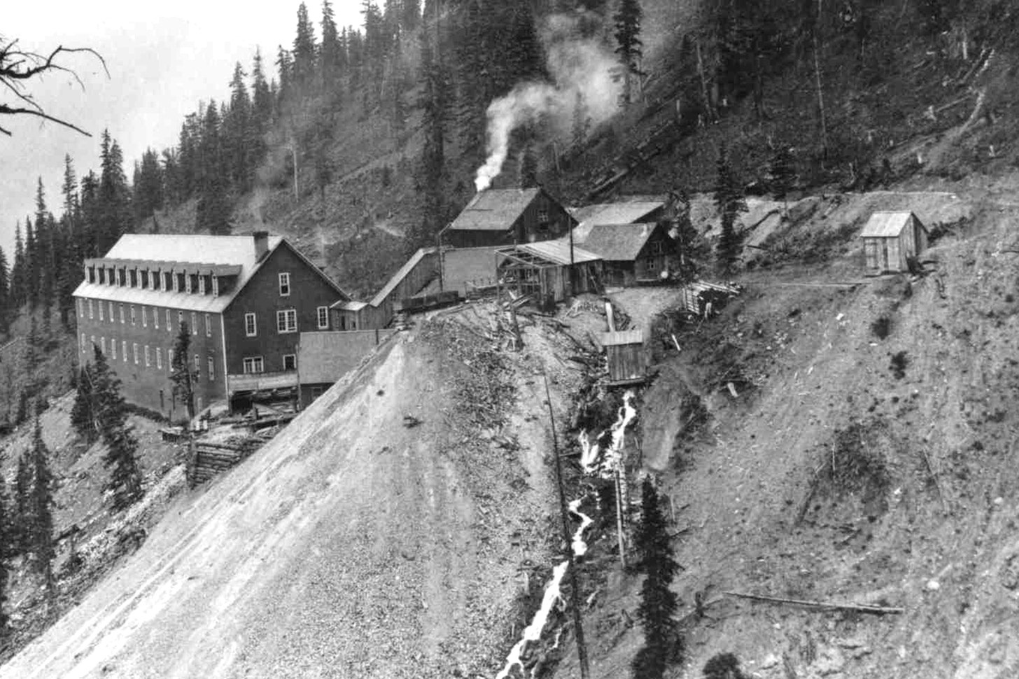
1897 About 40 employees pull ore from the Gold King mine’s 2,000 feet or so of underground workings and ships it down a 5,600-foot long tramway from the mine opening’s lofty perch on Bonita Peak’s slope to a new mill at Gladstone for processing.
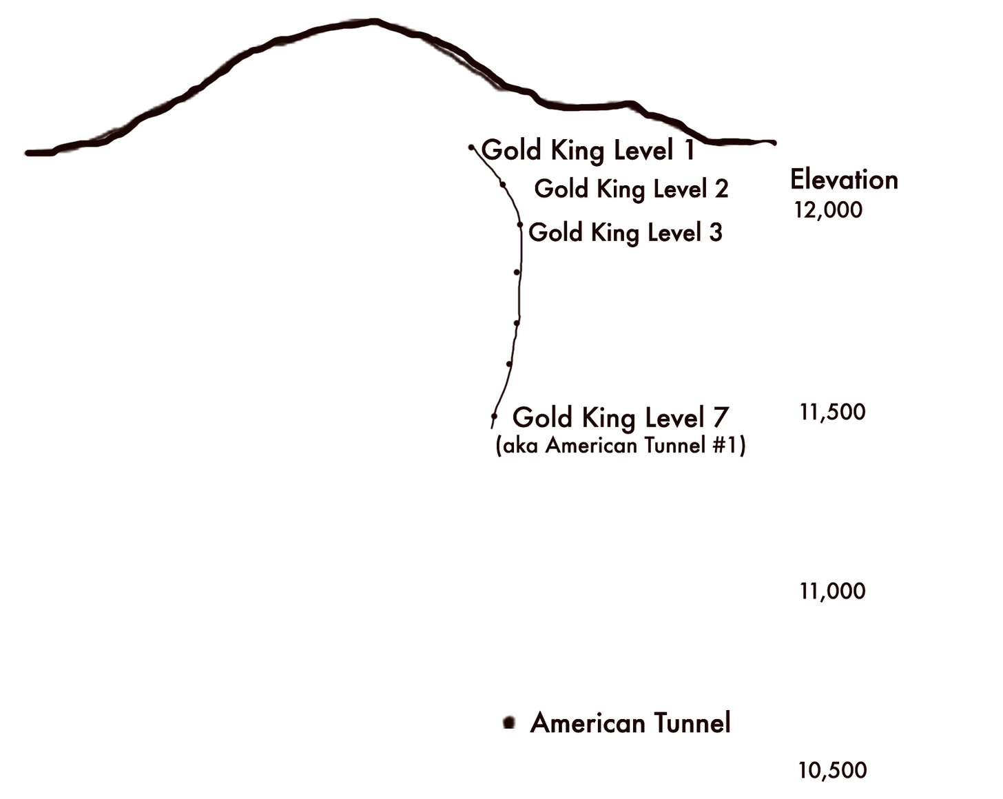
1898 The Gold King owners form the American Mining and Tunnel Co. and begin construction on a lower-elevation, safer access to the Gold King Mine several hundred feet below the current access adit (Gold King Level #1). They originally name the lower access point the American Tunnel, but after it is completed in 1903 and becomes the mine’s primary portal, it will be renamed the #7 Level of the Gold King Mine. This is level that will blowout in 2015 and is not the same American Tunnel in which Sunnyside placed its bulkheads many years later.
1900 USGS geologist Frederick Ransome visits the Gold King Mine, noticing that the main adit—or opening to the mine—is not draining any water, which is highly unusual for the area. He hypothesizes that the American Tunnel #1 (aka Gold King Level #7)—which at the time was under construction—is “deep draining” the water from the Gold King’s upper operations.
1900 The Gold King Mine owners begin construction on another American Tunnel (still known by that name today) at Gladstone. They plan to burrow into Bonita Peak until they are directly below the Gold King workings, then connect the two via a 1,000+ foot shaft. This will enable them to bring ore directly to the Gladstone mill, obviating the need to move it by tram across avalanche-prone terrain. But the project is abandoned after only 700 feet of tunneling (they need to go more than a mile underground before they will be in position to link with the Gold King).
1906 (or thereabouts) A photo of the Gold King Mine #7 Level appears to show about 200 to 300 gallons of water draining from the mine adit.
Gold King Mine drainage. Photo via The Land Desk
1908 The structures at the mouth of the Gold King #7 Level catch fire, destroying the tram terminal, boardinghouse, compressor house, carpenter shop, and stables, killing six. The mine rebuilds, but it will never be the same. In 1909 the new boardinghouse burns, killing a waiter, and in 1911 an avalanche hits the boardinghouse, killing four people. After that operations are on-again, off-again and profits hard to come by.
1921 The Gold King miners are working again to open the Gladstone tunnel, aka. the American Tunnel, that goes from the Gold King mill at Gladstone into Bonita Peak and under the Gold King Mine, about 860 feet below the Gold King #7 Level. The intent is to provide a long haulage tunnel for Gold King ore, thereby rendering the treacherous trams obsolete, but the connection to the upper mine is never made. A later report indicates that the American Tunnel is 6,233 feet deep when work is finally halted. The tunnel “deep drains” the groundwater of Bonita Peak, leaving the Gold King mine virtually dry.
This shows the relative elevations of different levels of the Gold King and the American Tunnel. The Gold King was accessed via adits (mine openings) on Level 1 and Level 7. The other levels were mined, but did not have their own adits. Gold King Level 7 was called the American Tunnel when it was first built in the late 1890s, but the name was transferred to the far lower and longer American Tunnel that was originally built to link Gladstone with the Gold King Mine workings. The link was never completed and Standard Metals later took over the American Tunnel to access the Sunnyside Mine. Credit: The Land Desk
1922 The Gold King Mine’s parent company goes bankrupt, leaving the Sunnyside Mine, on the opposite side of Bonita Peak, as one of the region’s biggest mines. But it struggles because the mine opening is above the workings, meaning water and ore must be pulled up and out of the mine, against gravity, which increases operational expenses.
Text from a 1918 proposal to extend the Gold King Mine to meet up with the Sunnyside Mine workings. Credit: The Land Desk
1960 Standard Metals takes over the dormant Sunnyside Mine and plans to revive it by extending the unused, partially complete American Tunnel to access it. The tunnel will provide gravity-assisted ore-haulage and water drainage for the Sunnyside by way of Gladstone. When it’s finished, the tunnel is 11,000 feet long, and brings mining, and prosperity, back to Silverton.
General view of the Sunnyside Mine and Lake Emma, southwestern Colorado photo via the Denver Public Library
1978 On a Sunday, when no miners are working, the floor of Lake Emma collapses into the Sunnyside Mine, sending tens of millions of gallons of water shooting out the American Tunnel at Gladstone and shutting the mine down for months. To this day some folks remain suspicious of the collapse, theorizing that it was planned by a beleaguered company looking for an insurance payout: Miners had warned management about increasing amounts of water pouring into the mine and worried that they were getting too close to the lake’s floor. Ultimately, Standard Metals received $9 million, but they had to drag the insurance company to court to get it. The company will go bankrupt in the early 1980s and sell the Sunnyside Mine to Echo Bay, a Canadian company, doing business as Sunnyside Gold Corp.
1986 Meanwhile, a company called Gerber Minerals takes over the Gold King and sets about to re-open it. They apply for a mining permit for the Gold King, but not a discharge permit, because: “No drainage occurs from any of the portals—the district is deep-drained by the American Tunnel located at Gladstone.” As a result, the American Tunnel flows with about 1,600 gallons per minute of acidic, heavy-metal laden water draining into Cement Creek and, ultimately, the Animas River. Note: The first mile and some of the American Tunnel runs through Gold King Mine patented claims, meaning it belongs to the owners of the Gold King.
1987 Donald “Donnie” Goode killed when a 100-pound rock falls from the ceiling of Gold King #7 Level, about 2,500 feet underground, striking him in the head.
1988 Sunnyside overhauls the old American Tunnel water treatment plant. It uses one ton of lime per day to raise pH levels, causing toxic metals to precipitate out of solution and settle into ponds, cleaning the 1,600 gallons per minute of discharge to a level that can support sensitive fathead minnows. The process costs approximately $500,000 per year, and results in 365 tons per year of metal-laden sludge.
1991 The Sunnyside Mine closes for good. A year later the re-born Gold King suspends operations, as well, but holds onto its permits. In preparation for plugging, or bulkheading, the American Tunnel, Sunnyside Gold and Washington Mining Co. commission an exhaustive hydrological study of the Sunnyside, which concludes that bulkheads in the American Tunnel should not cause flooding of the Gold King, and that it would take 150 years for mine pool water to reach Cement Creek.
Cement Creek aerial photo — Jonathan Thompson via Twitter
1994 Animas River Stakeholders Group is formed as a citizen-led effort to study and address mining pollution in the watershed and propose realistic water quality standards. It’s seen as a collaborative alternative to Superfund. Bill Simon is chosen as coordinator. Other notable members include Peter Butler, who had just received his Ph.D. in natural resource management, Larry Perino of Sunnyside Gold, and Steve Fearn.
1996 Sunnyside enters into a consent decree with the state, a sort of pollution trading scheme. Sunnyside will install three bulkheads in the American Tunnel, one on its property to back up water into the Sunnyside’s workings, and two more on Gold King property nearer to the surface. They will also clean up a list of abandoned mines in the watershed in order to offset the increased heavy metal loading that will result when Sunnyside turns off its American Tunnel water treatment plant. At about the same time, the state division of minerals and geology inspects the Gold King and finds that it’s draining just one to two gallons of acidic, metal-laden water per minute, a mere trickle.
1996 The valve is shut on the first bulkhead over 6,000 feet into the American Tunnel, beyond the Gold King property line. Water backed up behind this will inundate the Sunnyside Mine workings and create what’s known as the Sunnyside mine pool. By robbing the system of oxygen, it should slow acid mine drainage reactions. Sunnyside also dumped 625 tons of lime in from the top of the mine to raise pH levels.
1991 The Sunnyside Mine closes for good. A year later the re-born Gold King suspends operations, as well, but holds onto its permits. In preparation for plugging, or bulkheading, the American Tunnel, Sunnyside Gold and Washington Mining Co. commission an exhaustive hydrological study of the Sunnyside, which concludes that bulkheads in the American Tunnel should not cause flooding of the Gold King, and that it would take 150 years for mine pool water to reach Cement Creek.
1997 A Gold King Mines environmental protection plan notes that the mine is discharging between 4 gpm and 30 gpm, with a pH as low as 2.25. However, the authors of the report theorize that it’s groundwater, not Sunnyside mine pool water, based on the 1992 hydrology report. A 1998 inspection finds that the Gold King #7 level portal had collapsed, just inside the portal, and is impassible. It does not say how much water is draining from the mine.
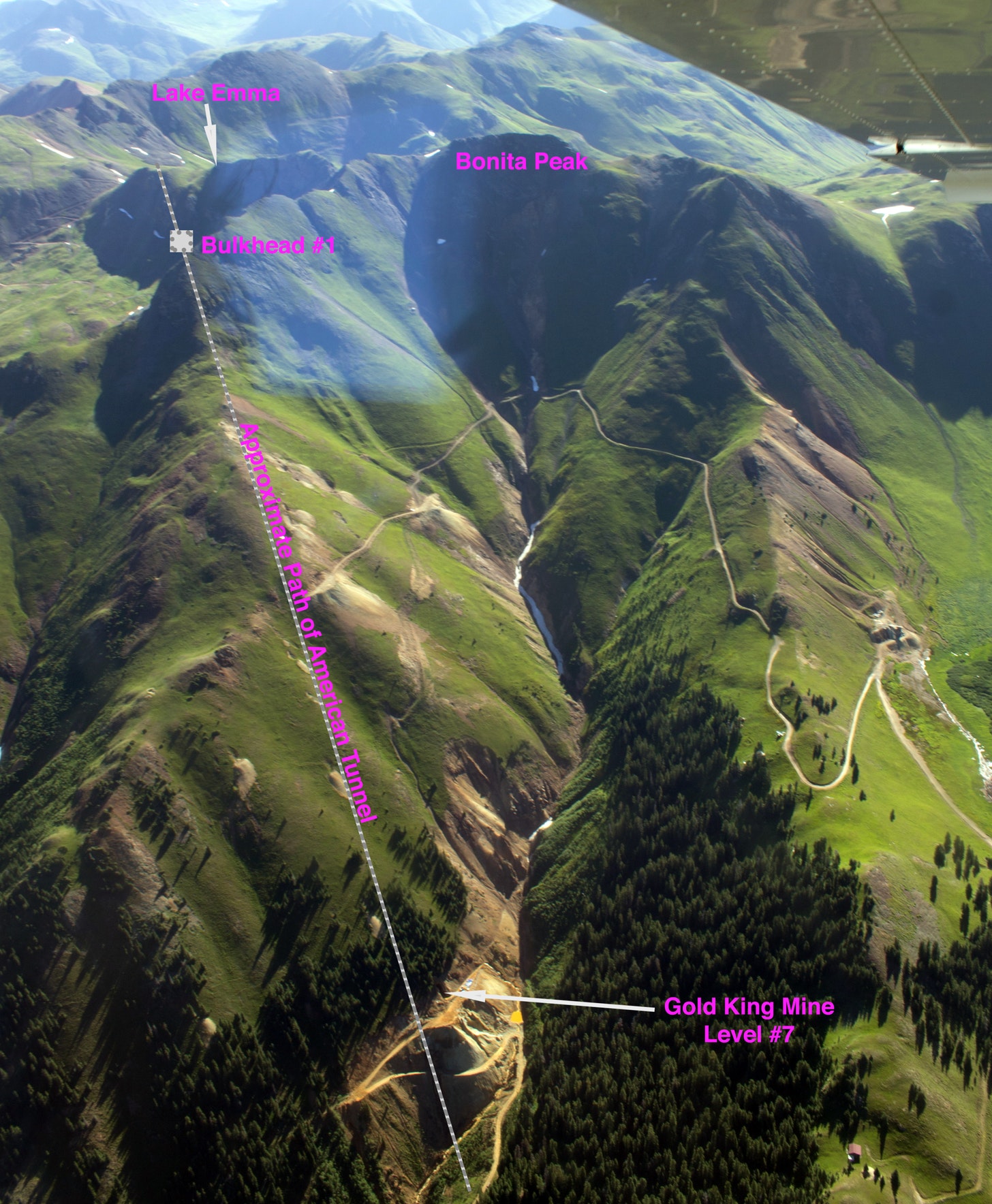
An aerial view of the Gold King Mine days after the 2015 blowout showing the approximate path of the American Tunnel, which runs beneath the Gold King. The Sunnyside Mine is beneath Lake Emma. Jonathan P. Thompson photo enabled by EcoFlight.org.
1999 A water analysis report of the Gold King Mine finds that the mine is discharging between 11 gpm and 30 gpm with a very low pH and very high concentrations of dissolved metals. The following year Steve Fearn buys the Gold King mine from CCTC, trustee for Pitchfork “M” Corp. The state inspection later that year notes: “Though this year has been abnormally dry, the No. 7 level discharge appears to have increased significantly … from around 30 gpm to around 45 gpm.”
2001 The Sunnyside Mine Pool is thought to have reached equilibrium, based on the findings of the 1992 hydrological study. The mine pool, some 1,200 feet deep, exerts nearly 500 psi on bulkhead #1. Sunnyside then installs bulkhead #2, which is closer to the surface and, in 2002, bulkhead #3, which is right at the surface, in preparation for its exit from the area. By now Sunnyside Gold has spent upwards of $25 million on cleanup and reclamation. Discharges from both the Gold King and the nearby Mogul Mine—which was also mostly dry prior to the first bulkhead installation—continue to increase.
2003 A byzantine agreement transfers ownership of the Sunnyside water treatment plant to Gold King owner Fearn, allowing Fearn to treat Gold King water, and allowing Sunnyside to leave—in theory. Also involved in the deal is Todd Hennis, owner of the Mogul Mine in the Cement Creek drainage, who acquires most of the Gladstone townsite. The deal will go bad a year later when Hennis evicts Fearn, and thus the water treatment plant, from his property at Gladstone, shutting down water treatment for good (proving detrimental to downstream fish populations). Meanwhile, Fearn’s mining ventures have gone broke. Hennis will acquire the Gold King and in coming years set about to mine it, first with a new company called Colorado Goldfields, and then on his own.
When treatment of water draining from the Gold King Mine ceased in 2004, downstream water quality—and fish populations—were negatively affected. Credit: The Land Desk
2005 Gold King mine discharges have increased to 200 gallons per minute or more. Animas River Stakeholders Group calls in the Environmental Protection Agency to help figure out the cause and potentially fund a solution. In its annual report to the Security Exchange Commission, Colorado Goldfields says it intends to re-open Gold King #7 Level, and that it hopes to enter into an agreement with the EPA allowing it to deal with increasing flows of acid mine drainage, which the company believes are coming from the “2150 vein workings of the Sunnyside Mine.” The report also notes the danger for a “blow out of potentially impounded mine waters.”
2009 The State Division of Mining Reclamation and Safety calls the Gold King, now dumping nearly 200,000 pounds of metals into the watershed per year, “one of the worst high quantity, poor water quality draining mines in the State of Colorado.” It backfills the mine portal, or opening, because it had collapsed, and installs drainage pipe.
2014 Sunnyside Gold Corp. offers $10 million towards water treatment and other upper Cement Creek cleanup—as long as Superfund isn’t declared.
2015 EPA contractors begin excavating dirt piled up at the opening of Gold King Mine #7 Level until the operator notices a “spring” spurting from the dirt. Within minutes, the tiny fountain has grown to a 3-million gallon torrent of electric-orange, acidic, heavy metal-laden water pouring into the North Fork of Cement Creek far below.
Prior to mining, snowmelt and rain seep into natural cracks and fractures, eventually emerging as a freshwater spring (usually). Graphic credit: Jonathan Thompson
So, yeah, I know: That made it about as clear as the Animas River was in the days following the blowout. This puzzle will never be solved definitively. Bonita Peak’s hydrology is all a tangled maze of fractures and faults and veins, a sort of lithic Swiss cheese comprised of hundreds of miles of drifts, shafts, crosscuts, and tunnels, creating innumerable potential paths the water could follow.
But from what we can glean from the history we can conclude:
• The Gold King Mine had water flowing through it early on. When the first American Tunnel, aka #7 Level, was dug, it deep drained the upper levels, making them appear to be dry.
• About 200 to 300 gallons of water per minute flowed out of the #7 Level adit until the new American Tunnel was drilled under the Gold King in the 1920s, deep draining the entirety of Bonita Peak.
• It wasn’t until after Sunnyside installed bulkheads in the American Tunnel that drainage returned to the Gold King #7 level (as well as to the Mogul Mine). It’s safe to conclude in this case that correlation is causation: The installation of the bulkheads caused drainage to return to the Gold King.
Not clear, though, is precisely where the water was coming from: Did the Sunnyside mine pool water back up, then find a pathway through to the Gold King Mine? If so, then it would seem that Sunnyside is at least partially responsible for the resulting 2015 blowout, since that nasty orange water originated on its subterranean property. Or did the lower two bulkheads—which are on Gold King property—simply return Bonita Peak’s hydrology to a pre-American Tunnel state of affairs, or a “natural flow regime,” as one Sunnyside employee put it in the early 2000s? In that case it is not Sunnyside Gold’s water, it’s the Gold King’s, which would absolve Sunnyside of responsibility.
While conclusive answers to those questions aren’t exactly forthcoming, a look at the timeline suggests that the water that spewed from Gold King #7 Level on Aug. 5, 2015, may have come from both sources. Drainage from the Gold King first started increasing—albeit only marginally—in 1997, after bulkhead #1 had been installed but before the next two were sealed. But flows remained pretty low until after the valves on bulkheads #2 and #3 were closed. It was only then that the Gold King became a major source of acid mine drainage and conditions established that would lead to the blowout.
But at this point maybe it doesn’t matter: Even if Sunnyside could prove that it’s not liable for what happened in 2015, it still would have been the last and only viable mining concern in the vicinity when it happened. Whether it’s culpable or just happened to be in the wrong place at the wrong time is probably irrelevant. In either case, the company would have had to take responsibility or else risk damaging its corporate image. That’s the price one pays for playing the mining game.
From email from the High Line Canal Conservancy (Suzanna Fry Jones):
The Canal Collaborative officially launches to formalize the new governance model, making permanent the powerful public-private partnership between 13 regional partners, including the High Line Canal Conservancy and Denver Water
Denver, CO (January 26, 2022) – The High Line Canal Conservancy today announces the public-private partnership known as the Canal Collaborative that formalizes a new partnership between 13 regional entities to preserve, protect and enhance the 71-mile High Line Canal. This powerful collaborative brings partners together in a collective impact model – working together to support the Canal’s transition from a part of Denver Water’s historic irrigation system to its new role as a 71-mile linear park and emerging stormwater management system. The newly formed Canal Collaborative formalizes roles and responsibilities for the long-term management, funding and governance of the Canal
“This Partnership was built on the premise that together we can do more for the Canal than any one entity can do alone. The deep respect for varied local perspectives, combined with the power of the community’s vision and commitment has been a winning strategy that has resulted in a common vision and new governance structure to ensure the Canal is cared for as a vital backbone of our region’s open space system for generations to come,” said Harriet Crittenden LaMair, High Line Canal Conservancy Executive Director.
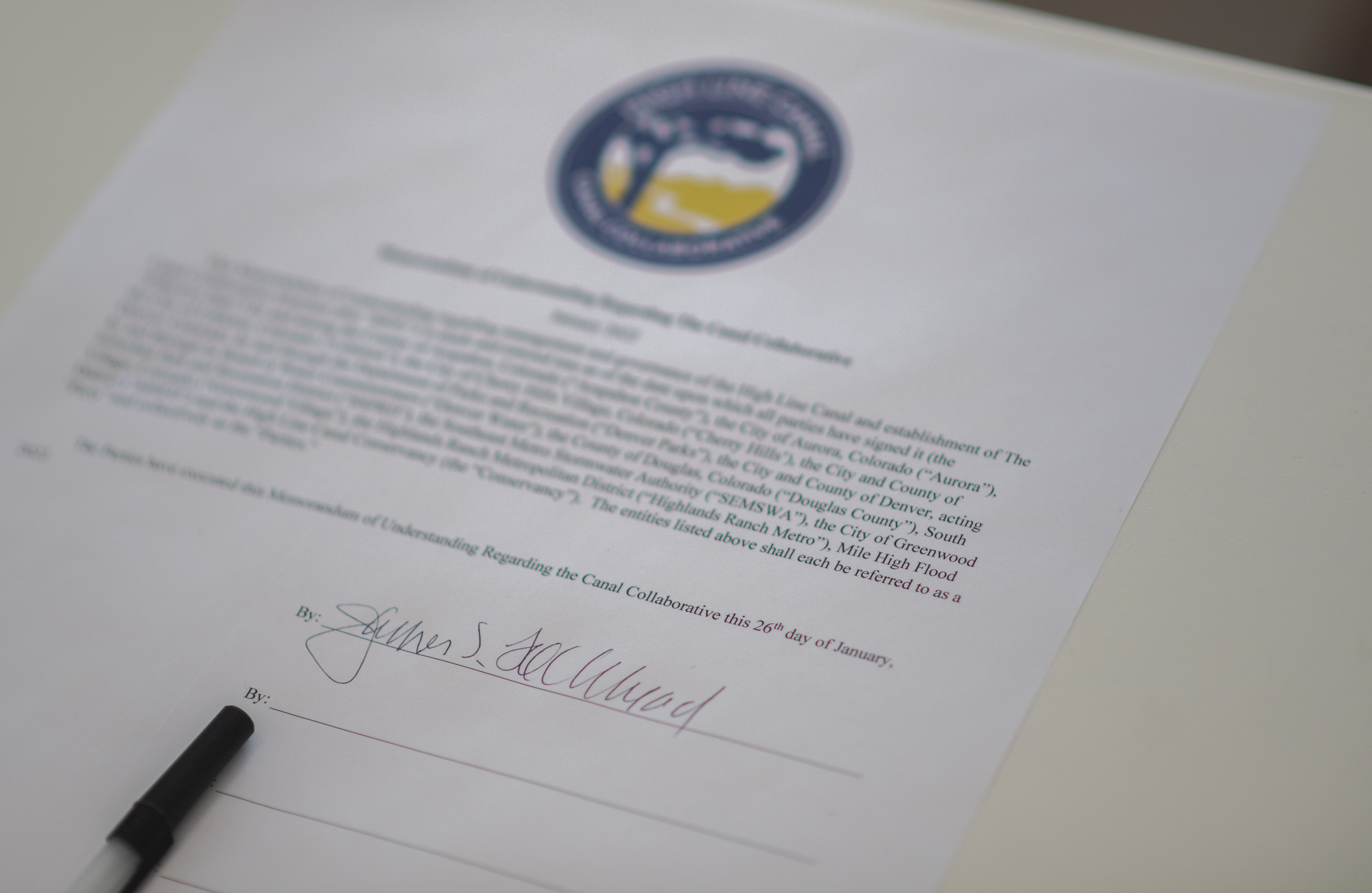
To formalize the launch of the Canal Collaborative, key leaders from across the region, joined together to witness Jim Lochhead, CEO and Manager of Denver Water, owner of the Canal, sign the long-awaited Memorandum of Understanding at the first annual State of the Canal. To a virtual audience of nearly 100, key leaders presented on Canal preservation and enhancement progress achieved to date and what’s to come in the next phase of improvements and implementation of The Plan for the High Line Canal (The Plan), including $130M dedicated for improvements over the next 15 years.
“Denver Water had a century old canal that had outlived its usefulness” said Jim Lochhead, Denver Water CEO. “We wanted to transform the canal into a recreational and environmental crown jewel for the region. And with the help of a dozen partners who shared the vision, we have come together to realize that vision through the Canal Collaborative.”
This model of regional collaboration started to take shape in 2010 when, for the first time in the 140-year history of the Canal, governments, agencies and a nonprofit partner from across the region stepped forward, committing to deep collaboration that resulted in a powerful regional community driven vision plan, a framework plan and new governance structure to guide the future of our regional legacy. These successful collaborations culminated in agreements to create the Canal Collaborative, memorializing collaboration in a collective impact model for long-term sustainability ensuring The Plan becomes a reality for the people of the region to enjoy for generations to come.
“Arapahoe County has committed tremendous resources to the Canal since 2010. We’re thrilled that this new entity will bring together the various jurisdictions so we can hear from each partner and the public about the best ways to preserve and protect the High Line Canal for the future,” said Arapahoe County Commissioner Nancy Sharpe.
Over the next 15 years, the collaborative will work together to implement over $130 million of trail improvements, including improved access and safety, enhanced environmental health for the region and improved quality of experience.
Canal leaders (left to right): Chief Executive Officer Jim Lochhead, Denver Water; Board Chair Paula Herzmark, High Line Canal Conservancy; Executive Director Harriet Crittenden LaMair, High Line Canal Conservancy; Commissioner Nancy Sharpe, Arapahoe County; Open Spaces Director Shannon Carter, Arapahoe County; Chief Operations and Maintenance Officer Tom Roode, Denver Water; Council Member Kendra Black, City and County of Denver; and Deputy Executive Director of Parks & Recreation Scott Gilmore, City and County of Denver. Photos by Evan Semón Photography 720-620-6767CEO Jim Lochhead of Denver Water signing the Memorandum of Understanding to officially launch the Canal Collaborative. Photos by Evan Semón Photography 720-620-6767Canal Collaborative Memorandum of Understanding. Photos by Evan Semón Photography 720-620-6767
LINCOLN – People lined up at the State Capitol Tuesday to support proposals by Gov. Pete Ricketts to spend the state’s allocation of $1.04 billion in American Rescue Plan Act (ARPA) funds.
Mental health providers praised his idea of setting aside $40 million for new treatment facilities. Sports and arts groups supported the $100 million set aside for COVID-19 impacted, “shovel ready” projects. And a rural firefighter thanked Ricketts for earmarking $35 million to replace aging ambulances across the state.
In addition, representatives of the state’s community colleges lauded the idea of getting $90 million to enhance training in trades that have shortages right now, including truck drivers and nursing aides.
But several questions were raised about the governor’s most expensive proposal — setting aside $500 million to build a long-forgotten irrigation canal on the South Platte River.
Ricketts has proposed utilizing $100 million in AARP funds and $400 million in state cash reserve monies to resurrect the Perkins County Canal project, which would divert waters of the South Platte near Ovid, Colorado, and deliver it to Nebraska, likely for irrigation.
Canal proposed in 1890s
The canal was first proposed in the 1890s, but construction was halted in 1894, due to a lack of funds, after only a couple miles were dug.
But the Perkins County Canal was included in a 1923 water compact reached between Nebraska and Colorado over each state’s rights to the flows of the South Platte. And now Ricketts has dusted off the old canal project in an effort to capture the water guaranteed under the compact.
Tom Riley, the director of the Nebraska Department of Natural Resources, said that construction of the canal is the only way Nebraska can “preserve and protect” its water allocation.
But two senators on the Appropriations Committee, Steve Erdman of Bayard and Mark Kolterman of Seward, questioned how such a pricey, long-forgotten project suddenly became a big priority.
And what about the half-billion-dollar pricetag, Kolterman asked. “That is a lot of money,” he said.
“Projects of this nature are expensive,” Riley said, adding that the cost estimate was based on projections made in the 1980s.
The State of Colorado, he said, is spending “20 times that amount” on its water projects impacting the South Platte, which flows through fast-growing Denver.
‘Colorado is concerned’
He said Nebraska needs to start the canal project now, to preserve its water allocation before Colorado snaps it all up.
“Colorado is concerned and is looking to accelerate their projects,” Riley told the Appropriations Committee.
But Laurel Sariscsany of the Open Sky Policy Institute, a Lincoln-based think tank, said the canal could end up bogged down in lengthy litigation with Colorado. That raises concerns that the ARPA funds would not be spent by the 2026 deadline, she said, resulting in the federal government taking back those funds.
Overall, Sariscsany questioned why about 25% of the governor’s ARPA proposals dealt with sewer and water infrastructure projects when the state expects to get $358 million for such projects from the recently passed federal infrastructure bill.
Better uses for funds
Former State Sen. Al Davis, now a lobbyist for the Sierra Club, asked whether there were higher priorities than the Perkins County Canal on which to spend $500 million, such as improving the state’s existing parks.
In a recent interview with the Nebraska Examiner, Dave Aiken, a water law authority with the University of Nebraska-Lincoln, said the influx of federal funds has made the Perkins County Canal suddenly feasible.
Clearly, Aiken said, Colorado is ahead of Nebraska in planning projects that utilize the South Platte’s flows, but the Perkins Canal idea has certainly grabbed their attention. Whether or not state lawmakers agree to set aside a half-billion dollars is a big question, he added.
“I can’t believe that all $500 million is going to end up in the Perkins County Canal project, but we’ll see,” Aiken said.
Gering Sen. John Stinner, who chairs the Appropriations Committee, said the committee might want an additional briefing about the canal project. “These are big-time dollars,” he said of the project’s cost.
The Appropriations Committee took no action on the governor’s ARPA proposals after a public hearing that extended into the evening. The committee will make budgetary decisions later, which will be debated by the full Legislature.
Nebraska Examiner is part of States Newsroom, a network of news bureaus supported by grants and a coalition of donors as a 501c(3) public charity. Nebraska Examiner maintains editorial independence. Contact Editor Cate Folsom for questions: info@nebraskaexaminer.com. Follow Nebraska Examiner on Facebook and Twitter.
Colorado securities regulators have filed a $19 million fraud suit against a troubled Colorado water company, charging that it misled investors and sold shares in subsidiaries illegally.
The lawsuit, filed Dec. 10 in Denver District Court, alleges that Denver-based Two Rivers Water & Farming LLC, failed to properly register its stock sales as required by law and misappropriated money.
The Two Rivers subsidiaries, including GrowCO, Inc. and TR Capital Partners, among others, were described to investors as cannabis businesses that planned to build high-tech greenhouses for growing hemp.
In court filings, however, the state securities commission alleges that only one $5 million greenhouse in southern Colorado was ever built, and that other funds raised were misappropriated.
In a Jan. 18 response to the state’s suit, former Two Rivers officers denied the state’s allegations, saying that in several instances cited by the state, the securities weren’t required to be registered and that during certain periods between 2014 and 2019, the defendants weren’t responsible for Two Rivers’ actions because they were not officers at the time.
The defendants, including John McKowen, Jan McCaffrey, George McCafffrey, Wayne Harding, Edward Wallick, Richard WiWi and Kirsty Cameron, asked that the state’s suit be dismissed.
Neither Colorado Securities Commissioner Tung Chan, or Martin Berliner, the attorney representing the Two Rivers’ defendants, responded to requests for comment.
A message left at Two River’s Denver office for current CEO Greg Harrington was not returned.
Two Rivers Farming and Water is listed under the symbol TURV on the Over The Counter (OTC) index. Unlike major stock exchanges, such as the New York Stock Exchange, OTC stocks aren’t closely regulated, nor are they required to provide as much financial information to investors.
TURV stock is listed as an OTC security on the website OTC Markets, but is flagged with warnings, in part because it has failed to file the required financial reports for several years.
In 2020, the Colorado Water Conservation Board (CWCB), moved to foreclose on land and water rights in the Arkansas Valley owned by Two Rivers, to satisfy $1.4 million in delinquent loan payments and dam repair bills.
Last August, however, Two Rivers paid the state $161,000 to cover the late payments, causing the state to stop foreclosure proceedings, according to Kirk Russell, who oversees the CWCB’s loan program.
“When they came to us (in 2012) and desired to get ag land back into production, we thought it was a great idea,” Russell said. “But the organization was just a bad one to start with.”
How many people still own shares in the company isn’t clear. Its stock has traded for as little as 12 cents a share to more than 70 cents a share. In various debt offerings since 2012, the company has issued millions of shares of stock, often using them as collateral for loans from investors.
Chris Scott is a tax attorney and a Two Rivers shareholder. He, along with 55 other investors, is suing Two Rivers in a separate suit. He said it’s not clear what will happen as a result of the Colorado Securities Commission’s action. But he said he would like to see a new management team installed at the company.
“The only reason I invested was because people I formerly trusted told me what a great deal this was going to be,” he said.
Two Rivers’ next payment to the state is due March 1, Russell said. If that payment is missed, the CWCB has said it will resume legal proceedings against the company.
Jerd Smith is editor of Fresh Water News. She can be reached at 720-398-6474, via email at jerd@wateredco.org or @jerd_smith.