Click on a thumbnail graphic to view a gallery of drought data from the US Drought Monitor.
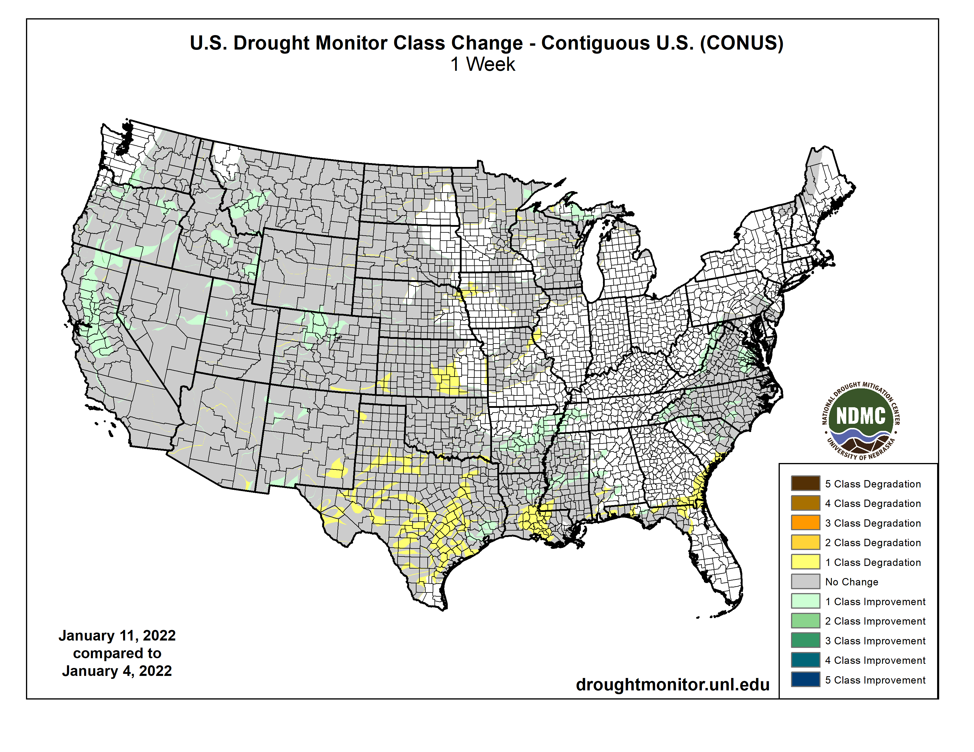
US Drought Monitor map January 11, 2022.
High Plains Drought Monitor map January 11, 2022.
West Drought Monitor map January 11, 2022.
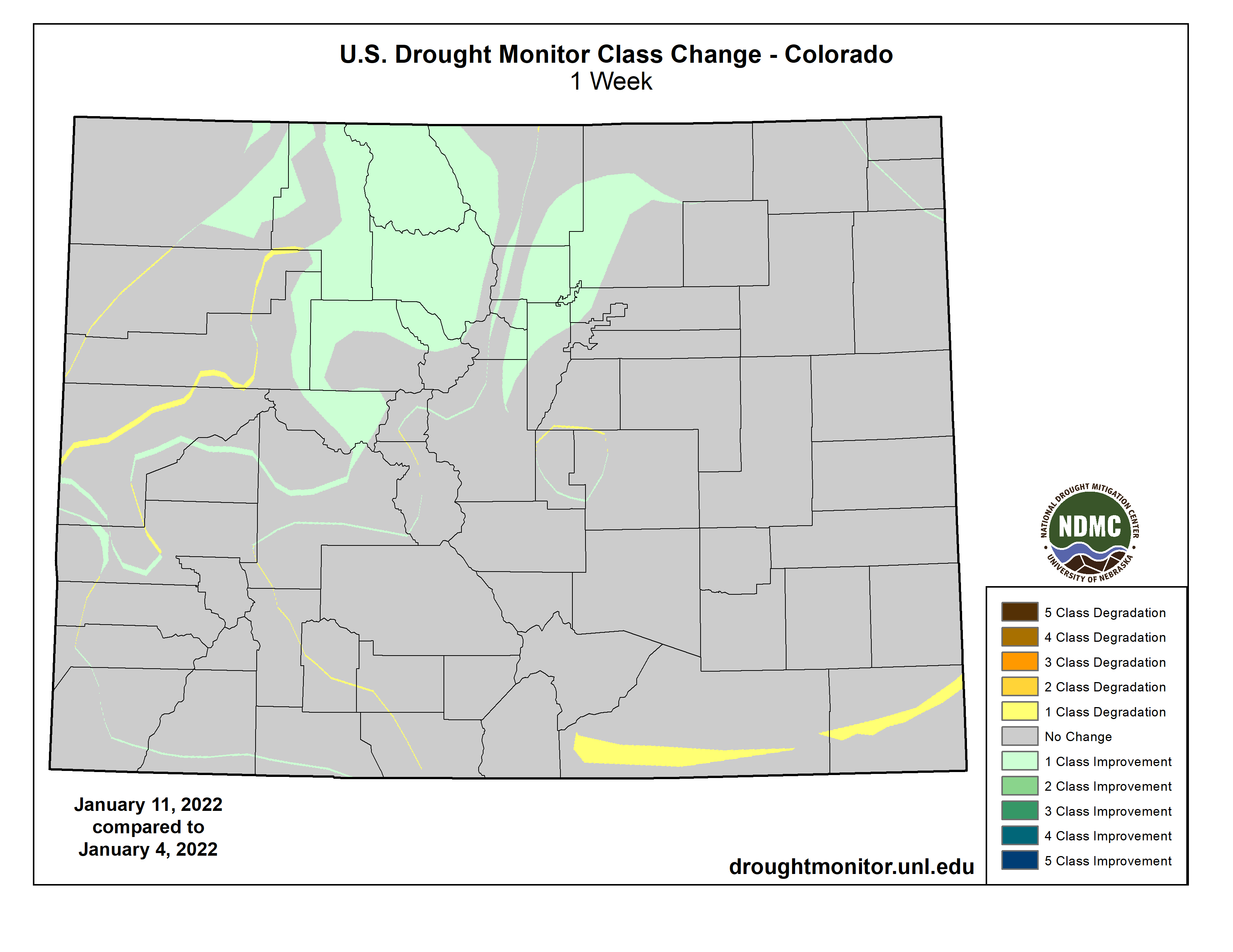
Colorado Drought Monitor map January 11, 2022.
Click here to go to the US Drought Monitor website. Here’s an excerpt:
This Week’s Drought Summary
Heavy precipitation pelted the northern half of the West Coast again this week. The largest amounts were reported in westernmost Washington and adjacent Oregon, where 6 to 10 inches of precipitation fell. Similar totals – though less widespread – were recorded across the northern half of the Cascades. Amounts decreased moving southward, with coastal areas and higher elevations from central Oregon to northwestern California receiving 2 to locally near 6 inches. Farther east, 2 to 3 inches were common across the Idaho Panhandle and the higher elevations farther south and east, including western Wyoming and north-central Colorado. Farther east, heavy precipitation also pelted the southern Ohio Valley and the lower Mississippi Valley. Generally 2 to 3 inches, with isolated higher amounts, fell on a swath south of the Ohio River, central and northeastern Arkansas, and part of easternmost Texas. Moderate precipitation – 0.5 to 2.0 inches – fell on parts of the Pacific Northwest, the northern Intermountain West, and the central and northern Rockies adjacent to areas with higher amounts. Similar totals also fell on parts of the Great Lakes Region, and in the East from the Ohio River to the Atlantic and Gulf of Mexico coasts. Light to locally moderate precipitation (0.25 to locally over 0.5 inch) dampened most of the Carolinas, Virginia, the interior Northeast, and portions of the central and northern Great Plains. Elsewhere, little if any precipitation fell, including an area from Oklahoma and Texas westward across much of Nevada and southern California. Looking at the 48-states as a whole, there was considerably more improvement than deterioration, as most areas that were dry this week didn’t seem to deteriorate much, if at all…
Substantial precipitation (over 0.5 inch) was generally restricted to higher-elevation areas in Wyoming and Colorado. Farther east in the Plains States, only the northern and southern portions of the region recorded more than 0.2 inch. Some deterioration was introduced in southern Kansas where temperatures were the highest, but other areas from the Dakotas southward remained unchanged. Heavy precipitation has been common across the higher elevations of central and northern Colorado in the past couple of months. Some of these mountains received several inches more than normal precipitation in the last 90 days, resulting in abundant snowpack that prompted drought improvement through this region. Other areas were unchanged…
Colorado Drought Monitor one week change map ending January 11, 2022.
Another week of heavy precipitation affected the Pacific Northwest from the Cascades to the Pacific Coast. Precipitation was greatest in western Washington west of Puget Sound, where some areas recorded up to 10 inches of precipitation. Lesser but still above-normal amounts pelted central Washington and north-central Oregon. The valleys east of the Cascades recorded at least 0.5 inch while much of the northern Intermountain West – including most of Idaho and western Montana – reported just under an inch to nearly 3 inches in spots. Farther south, area near the coast as far south as northern California received multiple inches of precipitation, with totals closer to one inch noted in the higher elevations of northern California, including the northern Sierra Nevada. Moderate precipitation also fell on parts of northern Utah. From the Great Basin and central California southward through the southern Rockies – including the southern half of the Four Corners States – most areas received no precipitation. Based on the abundant precipitation and ample snowpack observed so far this winter, improvement was brought into several areas. Most notably, most of the large D3 area covering interior portions of northern and central California were reduced to D2. To the northeast, a significant portion of the D4 in southwestern Montana was improved to D3 for similar reasons. In addition, smaller areas across central Nevada, southern and eastern Oregon, and some central and southeastern portions of Idaho also saw significant improvement since the water year began…
Moderate to heavy precipitation abetted improvement in the eastern reaches of the region while little or no precipitation fell across Oklahoma, western Arkansas, and all but easternmost Texas. In sharp contrast, only light precipitation fell on areas along the Gulf Coast, and little if any precipitation fell on northwestern Arkansas, Oklahoma, and all but easternmost Texas. Over 2 inches of precipitation ended abnormal dryness across central Arkansas and all of Tennessee, save a small residual D0 area in the western part of the state. Heavy precipitation near the southern reaches of the Louisiana/Texas border also prompted some improvement in extreme eastern Texas. Elsewhere, dryness and drought persisted or deteriorated; this region was the only one to experience considerably more deterioration than improvement. Moderate drought expanded southward through most of Louisiana, and many of the D0 to D3 areas increased in coverage across Texas expanded, thus deterioration covered a large proportion of the state…
Looking Ahead
January 13-17, 2022 should bring more precipitation to parts of the East and Southeast. A broad area from Alabama and Georgia northward through the Carolinas, Virginia, and the Northeastern coastline should get over an inch, with scattered area of up to 2 inches in the southern Appalachians, near the Georgia/Alabama border, and in eastern North Carolina. Meanwhile, moderate precipitation of generally 0.5 to 1.0 inch is forecast across the interior Northeast and New England, and also in a swath from central North Dakota southeastward through Iowa and northern Missouri. Similar totals are expected in the coastal Northwest and the northern half of the Cascades, which will be considerably less than what the region has received for much of the winter. The rest of the 48-states will only see light precipitation at best. Most of the country west of the Appalachians should end up at least somewhat milder than normal for the period, especially from the Great Basin through the northern High Plains and Rockies, where temperatures are expected to average 8 to 16 degrees F above normal. Noticeably subnormal temperatures should be restricted to the Northeast, possibly reaching as far south as the Carolinas.
The Climate Prediction Center’s 6-10 day outlook (valid Jan 18-22, 2022) slightly favors above-normal precipitation across northern portions of the Rockies and Plains, across most of New England, and in the South from the Big Ben of Texas to the Atlantic Coast as far north as southern Virginia. In contrast, odds slightly favor below-normal precipitation in a swath from the central Ohio Valley westward into the south-central Plains. Better odds for drier than normal conditions cover much of the Four Corners States, the Great Basin, and much of the West Coast. Areas from the West Coast through the southern half of the Plains and the lower Mississippi Valley have enhanced chances for above-normal temperatures, but odds favor cooler than normal weather in the northern Plains, Great Lakes Region, Northeast, and Middle Atlantic States.
US Drought Monitor one week change map ending January 11, 2022.
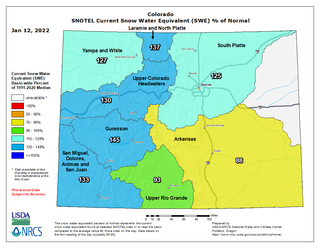
Colorado snowpack basin-filled map January 12, 2022 via the NRCS.
Click here to read the newsletter. Here’s an excerpt:
IT SNOWED!
After a very dry November, a series of December storms significantly boosted the Colorado Basin snowpack. The January 6 Colorado Basin River Forecast Center Water Supply Forecast Discussion has details. It also notes that fall soil moisture levels, which affect runoff efficiency, were better in 2021 than in 2020, although still below average.
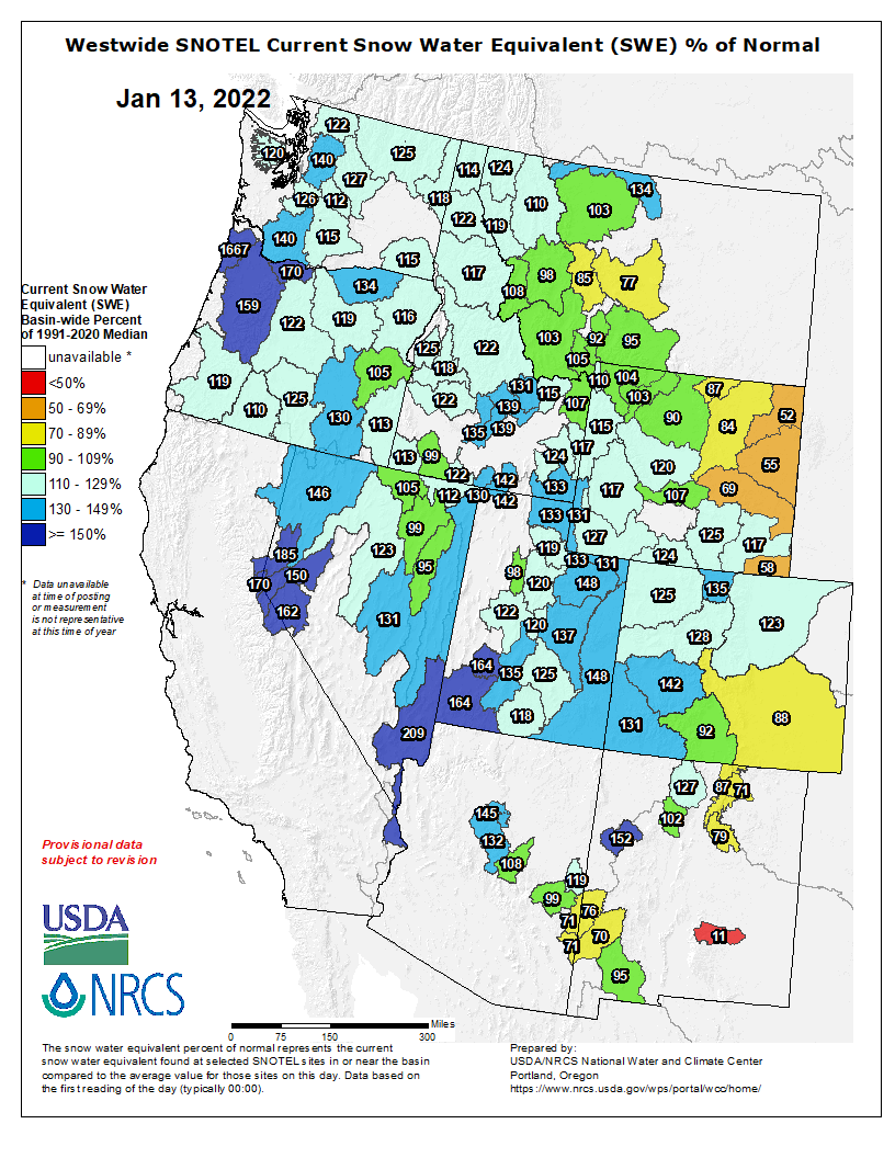
Westwide SNOTEL basin-filled map January 13, 2022 via the NRCS.
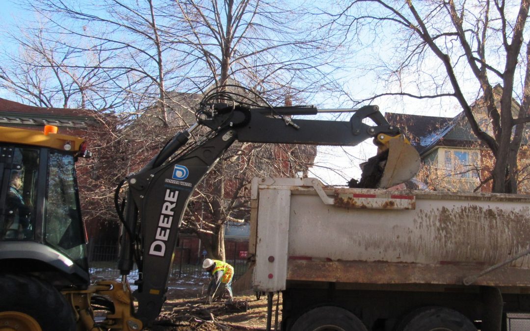
Hundreds of Denver property owners have failed to respond to requests or have directly refused to allow Denver Water to replace lead service lines leading to homes and businesses, a situation that jeopardizes the city’s efforts to keep lead out of drinking water.
The pipe replacement program, one of the largest in the country, is being done to help the agency comply with the federal Safe Drinking Water Act, which sharply limits lead in drinking water.
Since the program’s approval by the U.S. Environmental Protection Agency and the Colorado Department of Public Health and Environment in 2020, Denver Water has replaced some 10,000 service lines out of 68,000 targeted in the program.
But the agency has yet to decide how to bring reluctant property owners into the fold, according to Alexis Woodrow, Denver Water’s lead reduction program manager.
“Of course we would like to get 100% consent or compliance and we’re continuing to come up with communications to make sure homeowners understand the why behind this work,” Woodrow said.
According to data obtained by Fresh Water News through an Open Records Act request, 534 property owners, roughly 5% of those targeted by the program to date, have either failed to respond to the agency’s request to replace the service lines or have specifically refused to allow the work to be done.
Top reasons for refusing, according to Woodrow, are that homeowners don’t want their landscapes disturbed or they believe their lead service lines have already been replaced.
Denver, which is Colorado’s largest municipal water utility, has known lead was present at the tap in some of its customers’ homes since it appeared in routine sampling in 2013. The levels exceeded the benchmarks set under the Safe Drinking Water Act.
For several years, the utility ran pilot tests and negotiated with CDPHE and EPA over how best to eradicate the harmful metal. Though the amounts of lead found in Denver’s tap water samples varied, no amount of lead is considered safe to ingest, especially for young children.
Though lead isn’t present in the city’s treated water, it shows up at customers’ taps if it is delivered through aging lead service lines, where corrosion allows it to seep into the supply.
Cities across the country, including Pittsburgh, Penn., Newark, N.J., and Washington, D.C., have been dogged by an increase in lead contamination as service lines age and corrode, allowing the lead to comingle with water supplies, eventually reaching taps.
The CDPHE issued an order in 2018 requiring Denver to begin adding phosphorous to its water, one of the most effective ways to reduce corrosion in pipes. But phosphorous is also a pollutant and causes problematic algae blooms in lakes and rivers. Adding it to the municipal drinking water supply would also make it harder for wastewater treatment operators to meet their own obligations to keep phosphorous out of rivers and streams.
Due to those concerns, Aurora, Metro Water Recovery, The Greenway Foundation, and eventually Denver, sued the CDPHE in 2018 to stop the order from taking effect.
The dispute was settled after Denver was able to obtain a rare variance under the Safe Drinking Water Act in exchange for agreeing to invest some $68 million over 15 years to replace lead service lines, offer free water filters to residents as they wait for the new lines to be installed, conduct community education programs, and increase the pH of the water supply to also help reduce corrosion in pipes.
In earlier negotiations the utility had proposed replacing the lines at a much slower rate that would have taken decades to complete.
MaryAnn Nason, CDPHE spokesperson, said the agency is happy that Denver Water has been able to replace so many lines so quickly.
“While we are pleased, our goal is to have everyone participate or use a filter to keep themselves safe,” Nason said via email.
“When Denver Water’s program was approved, a strong outreach component was included. We wanted Denver Water to reach out to the community and provide educational materials about why this is important to do and how it protects public health. We understand the disruption to their lives is significant, but the outreach program is intended to help customers understand the safety and health benefits of replacing their service line,” she said.
Citing state privacy laws, Denver Water declined to identify addresses of properties that had not complied with the replacement requests. But an analysis of the zip codes where the agency has been shut out shows that the largest number, 124, are in 80205, which encompasses an area north and west of City Park and which includes Five Points and the Whittier neighborhoods.
The zip code with the second largest number of non-compliant property owners, 72, is 80220, an area that includes South Park Hill, Montclair and Hilltop.
Though no large apartment complexes have refused to replace lead lines, according to Denver Water, dozens of small multi-family units have yet to agree to have the work done, according to Fresh Water News’ analysis.
Tom Romero, an associate professor of law at the University of Denver and an expert on water equity issues, said the replacement program is critical to providing safe drinking water to everyone in the city.
“I definitely am concerned for all of those residents where you have recalcitrant property owners that are refusing to have these lead pipes replaced,” Romero said.
“This is definitely a public health issue,” he said. “It’s pretty remarkable that they have been able to get a 95% response, but any lead level is putting people at risk. It goes to the duty of Denver Water to provide safe drinking water to us all.”
This year is the third year of program, and is a critical benchmark with the EPA, which will decide later this year whether to allow Denver to continue the work, or use a different strategy.
Denver Water’s Woodrow said the agency is still trying to decide how aggressive to be with reluctant property owners because legally it could access the properties without the owner’s consent.
“We have discussed internally if we could compel the customer,” she said. “But we haven’t gotten there yet in terms of making a decision.”
But that may change.
“When you’re looking at the long-term strategy, we’re going to have to come up with additional tactics to get these lines replaced,” she said.
Jerd Smith is editor of Fresh Water News. She can be reached at 720-398-6474, via email at jerd@wateredco.org or @jerd_smith.
Click here to read the newsletter. Here’s an excerpt:
Can the Law of the Colorado River Adapt to an Increasingly Drier Hydrology?
A Two-Part Article by John McClow, UGRWCD Legal Counsel
The Gunnison River is a major tributary of the Colorado River. The Colorado River Basin has suffered from drought conditions throughout the 21st Century. The two major reservoirs in the Colorado River System – Lake Mead and Lake Powell – are at historic and dangerously low storage levels. Locally, Blue Mesa Reservoir is a stark illustration of the effects of the current dry conditions. Scientists are warning that “drought” is a term that no longer applies because it implies a temporary condition from which the Basin will recover. A more accurate term is “aridification” because the conditions we have experienced during the past 20 years will continue – or worsen – for the foreseeable future, as hotter and drier conditions make matters worse. Recently published projections indicate that river flows may decline 20 percent by midcentury and 35 percent by the end of this century. There is debate about the causes of the decline, but little disagreement that it will continue to happen. Can the Law of the Colorado River – numerous compacts, federal laws, court decisions and decrees, contracts, and regulatory guidelines – founded on a 100-year-old Compact – adapt sufficiently to meet the challenge of aridification?
Brad Udall: Here’s the latest version of my 4-Panel plot thru Water Year (Oct-Sep) of 2021 of the Colorado River big reservoirs, natural flows, precipitation, and temperature. Data (PRISM) goes back or 1906 (or 1935 for reservoirs.) This updates previous work with @GreatLakesPeck.
PART 1: A Brief Summary of the Law of the Colorado River
The foundation of the Law of the River is the Colorado River Compact, signed by the seven Colorado River Basin States and the United States in 1922. The Compact is a contract among the signatories ratified by the seven states and Congress and became state and federal law. The Compact divides the Colorado River Basin into an Upper Basin (Colorado, Wyoming, Utah, New Mexico) and a Lower Basin (Nevada, Arizona, California). It apportions to the Upper and Lower Basins the beneficial use of 7.5 million acre-feet of Colorado River water per year. It requires that the states of the Upper Basin will not cause the flow of the river to be depleted below an aggregate of 75 million acre-feet for any period of ten consecutive years – measured at Lee Ferry, the dividing point between the Basins. It also describes how the Basins will share water delivery to Mexico. The Compact contains no reference to “curtailment” or a “Compact call.”
In the 1928 Boulder Canyon Project Act, Congress authorized construction of Hoover Dam (Lake Mead) and directed that the 7.5 million acre-feet allotted to the Lower Basin under the 1922 Compact be apportioned: California, 4.4 million acre-feet; Arizona, 2.8 million acre-feet; Nevada, 300 thousand acre-feet.
The United States signed a treaty with Mexico in 1944 that guarantees an annual delivery of 1.5 million acre-feet of Colorado River water to Mexico. In 1948, the Upper Basin States signed the Upper Colorado River Basin Compact, which apportions the 7.5 million acre-feet allotted under the 1922 Compact: Colorado, 51.75 percent: Utah, 23 percent; Wyoming, 14 percent; New Mexico, 11.25 percent. The 1948 Compact created the Upper Colorado River Commission (UCRC), consisting of a Commissioner appointed by the Governor of each state and a federal Commissioner appointed by the President of the United States. It also provides that if curtailment of use in the Upper Basin is necessary to maintain the flow at Lee Ferry required by the 1922 Compact, the UCRC will determine each state’s extent and timing of curtailment. It is important to note that neither the 1922 Compact nor the 1948 Compact affect water right administration within the states. In Colorado, that authority remains vested in the State Engineer.
Graphic via Holly McClelland/High Country News.
In 1956, Congress passed the Colorado River Storage Project Act. The Act authorized construction of the reservoirs, dams and power plants of the initial units of the Project: Wayne N. Aspinall (originally the Curecanti Unit), Flaming Gorge, Navajo (reservoir and dam only), and Glen Canyon (Lake Powell), along with numerous participating projects, “making it possible for the States of the Upper Basin to utilize, consistently with the provisions of the Colorado River Compact, the apportionments made to and among them in the Colorado River Compact and the Upper Colorado River Basin Compact, respectively.” The CRSP power plants are an important source of hydropower in the Western United States, and the revenue from the sale of that hydropower supports operation of the Project and important salinity control and endangered fish recovery programs.
The Colorado River Basin Project Act, passed by Congress in 1968, authorized construction of the Central Arizona Project, which can divert 1.5 million acre-feet from the Colorado River to central and southern Arizona. Construction of the CAP allowed Arizona to develop its full apportionment of Colorado River water. The Act confirms California’s senior priority to 4.4 million acre-feet of Colorado River water, meaning that Arizona and Nevada must bear any shortage in the Lower Basin.
Next Issue: PART 2: Adapting the Law of the River for a Dry Hydrology
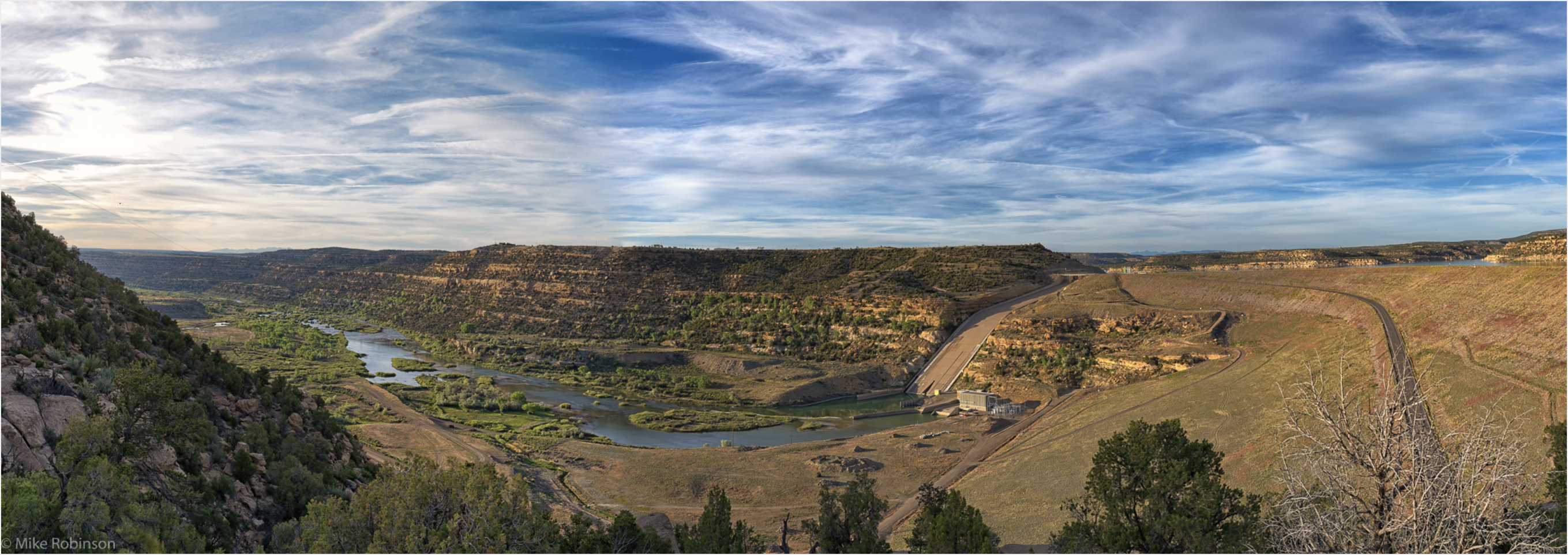
The Navajo Dam on the San Juan River.Photo credit Mike Robinson via the University of Washington.
From email from Reclamation (Susan Novak Behery):
In response to decreasing flows in the critical habitat reach, the Bureau of Reclamation has scheduled an increase in the release from Navajo Dam from 350 cubic feet per second (cfs) to 400 cfs for Thursday, January 13th, at 4:00 AM.
Releases are made for the authorized purposes of the Navajo Unit, and to attempt to maintain a target base flow through the endangered fish critical habitat reach of the San Juan River (Farmington to Lake Powell). This release change is calculated as the minimum required to maintain the target baseflow.
The San Juan River Basin Recovery Implementation Program recommends a target base flow of between 500 cfs and 1,000 cfs through the critical habitat area. The target base flow is calculated as the weekly average of gaged flows throughout the critical habitat area from Farmington to Lake Powell.