Devastating Colorado fires cap a year of climate disasters in 2021, with one side of the country too wet, the other dangerously dry — The Conversation #ActOnClimate


Wildfires that swept through Sequoia National Forest in California in September 2021 were so severe they killed ancient trees that had adapted to survive fires.
AP Photo/Noah Berger

Shuang-Ye Wu, University of Dayton

Alongside a lingering global pandemic, the year 2021 was filled with climate disasters, some so intense they surprised even the scientists who study them.

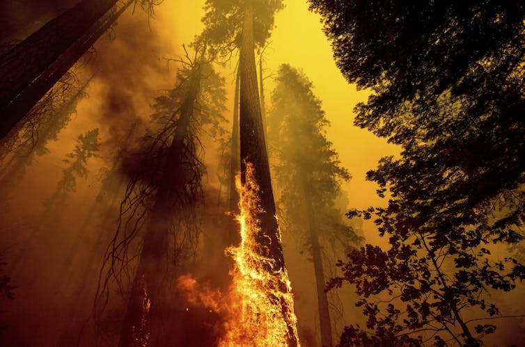
Extreme rainstorms turned to raging flash floods that swept through mountain towns in Europe, killing over 200 people. Across Asia, excessive rainfall inundated wide areas and flooded subway stations in China. Heat waves shattered records in the Pacific Northwest, Europe and the Arctic. Wildfires swept through communities in California, Canada, Greece and Australia.

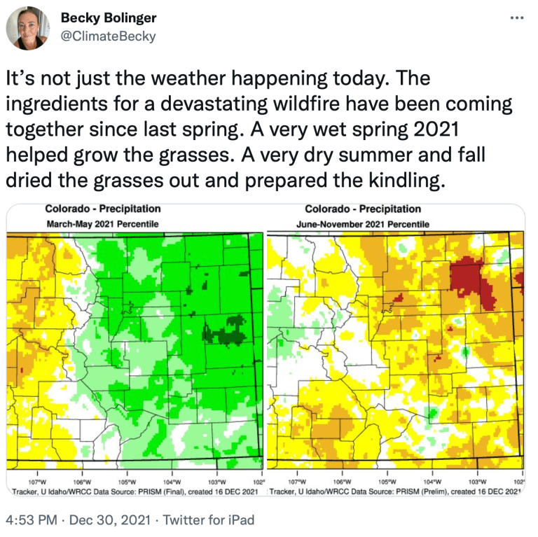
The area around Boulder, Colorado, was so unusually dry on Dec. 30, 2021, that a powerful wind storm sent grass fires racing through neighborhoods in Superior and Louisville, burning hundreds of homes in a matter of hours. Officials said the winds were so strong, there was little firefighters could do but evacuate homes and businesses in the fires’ paths.

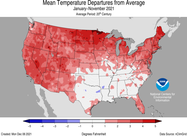
In the U.S. alone, damage from the biggest climate and weather disasters is expected to total well over US$100 billion in 2021. Many of these extreme weather events have been linked to human-caused climate change, and they offer a glimpse of what to expect in a rapidly warming world.

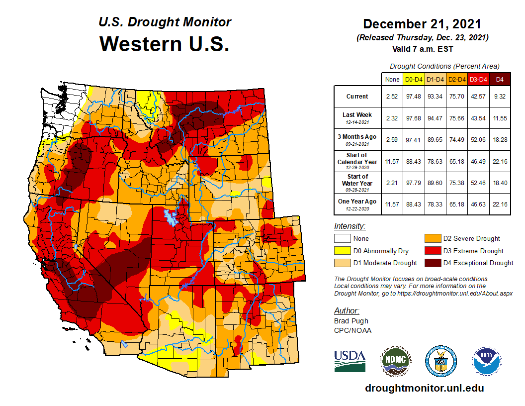
In the U.S., something in particular stood out: a sharp national precipitation divide, with one side of the country too wet, the other too dry.

As a climate scientist, I study the impact of global warming on precipitation and the water cycle. Here’s what happened with precipitation in the U.S. in 2021 and why we’re likely to see similar scenarios in the future.

The east-west weather divide

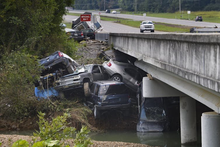
The eastern U.S. weathered storm after storm in 2021. Record rainfall in Tennessee triggered deadly flash flooding in August. The remnants of Hurricane Ida merged with another front days after the hurricane hit Louisiana and became so intense they set rainfall records and flooded subway stations and basement apartments in New York and Pennsylvania, with devastating consequences. Severe storms hit several states with deadly tornadoes in December.

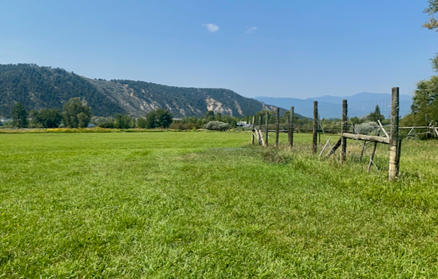
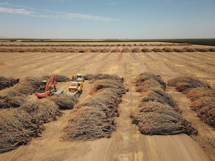
Almost the entire West, meanwhile, was in some stage of drought, helping to fuel wildfires that swept through forests and towns.

This kind of east-west weather divide can be enhanced by La Niña, a periodical phenomenon fueled by Pacific Ocean temperatures that tends to leave the Southwest drier than normal and the North and much of the eastern half of the U.S. wetter.

But something else is going on: Global warming fuels both dryness and extreme rainfall.

Several cars and a large pickup truck are piled up against a bridge after being swept downstream by a flood.
Flash flooding swept away cars and damaged homes in Tennessee in August 2021.
AP Photo/John Amis

3 impacts of global warming on rainfall

Three things in particular happen to precipitation when the planet warms.

1) Global warming increases evaporation, leading to more drying of land and plants and also more overall precipitation.

Higher temperature increases evaporation from Earth’s surface, drying out vegetation and soils, which can fuel wildfires. It also increases the atmosphere’s capacity to hold moisture at a rate of about 7% per degree Celsius that the planet warms. With more moisture evaporating, global precipitation is expected to increase, but this increase is not uniform.

2) Global warming leads to more intense precipitation.

With higher temperature, more moisture is needed to reach the condensation level to form precipitation. As a result, light precipitation will be less common. But with more moisture in the atmosphere, when storm systems do develop, the increased humidity leads to heavier rainfall events.

In addition, storm systems are fueled by latent heat – the energy released into the atmosphere when water vapor condenses to liquid water. Increased moisture in the atmosphere also enhances latent heat in storm systems, increasing their intensity.

Research shows that both the frequency and intensity of heavy precipitation events has increased since the 1950s over most land areas.

People walk down stairs into a flooded subway station.
The remnants of Hurricane Ida flooded subway stations in New York City in September 2021.
David Dee Delgado/Getty Images

3) Global warming tends to make wet places wetter and dry places drier.

Precipitation is not distributed evenly over the planet because of the global atmosphere circulation pattern. This global circulation brings moisture to places where winds come together, such as the tropical regions where we find most of the world’s rainforests, and away from places where winds diverge, such as the midlatitudes where most world’s deserts are located.

Assuming no significant changes in global wind patterns, increases in evaporation and moisture will mean more moisture is transported from dry areas to wet areas and into the storm tracks at higher latitudes. Global warming could also potentially change the global circulation pattern, causing a shift in the world’s wet and dry regions.

Rows of dead trees lie on their sides in a flat field.
A California farmer pulled out almond groves in June 2021 because of a lack of water to irrigate them.
Robyn Beck/AFP via Getty Images

Mountains, moisture and the east-west divide

These dynamics are also affected by local conditions, such as the shape of the land, the types of plants on it and the presence of major water bodies.

The western U.S., with the exception of the West Coast, is dry in part because it lies in the rain shadow of mountains. The westerly wind from the Pacific Ocean is forced upward by the mountain ranges in the West. As it moves up, the air cools and precipitation forms on the windward side of the mountains. By the time the wind reaches the leeward side of the mountains, the moisture has already rained out. As the wind descends the mountains, the air warms up, further reducing the relative humidity.

Higher temperature in areas like these where the moisture supply is already limited means less humidity in the air, leading to less rain. Higher temperature and less precipitation would also reduce snow packs in the mountains and cause earlier melt in spring. All these changes are likely to increase aridity in the West.

People looking from a viewing platform at Lake Mead, where a white ring on the stone walls shows how far water has dropped below normal.
The ‘bathtub ring’ around Lake Mead in July 2021 reflected record low water levels in the Colorado River reservoir, which fell below 35% capacity and triggered water use restrictions.
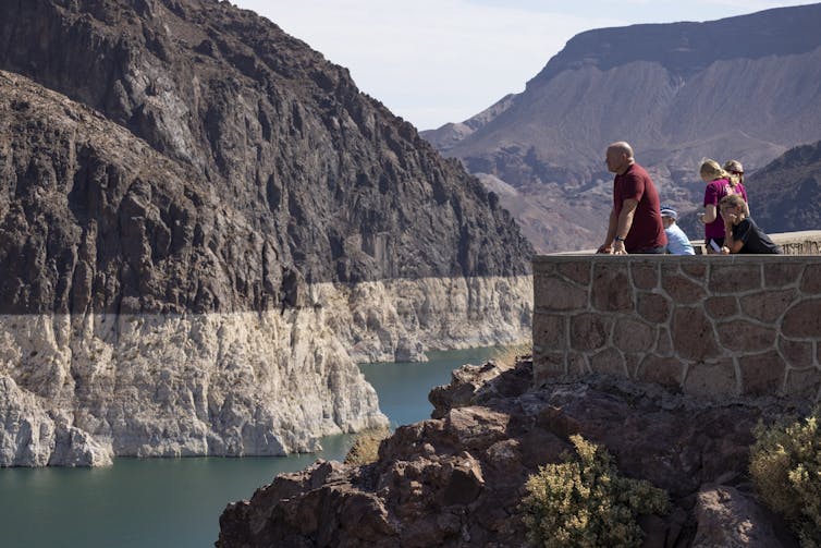
Photo by David McNew/Getty Images

The eastern U.S., on the other hand, receives abundant moisture from the North Atlantic and the Gulf of Mexico carried by the easterly trade wind. With abundant moisture supply, increasing temperature means more moisture in the atmosphere, leading to more precipitation and stronger storms.

This is what years of precipitation records show and what is projected for future precipitation based on climate models. Both show a decrease in annual precipitation in the West, likely meaning more long periods of drought, and an increase in the East with global warming.

[Read The Conversation’s newsletters to understand the world. Sign up today.]

This article was updated Dec. 30, 2021, with the fires in Boulder County, Colorado.The Conversation

Shuang-Ye Wu, Professor of Geology and Environmental Geosciences, University of Dayton

This article is republished from The Conversation under a Creative Commons license. Read the original article.

An ‘ambassador’ for the larger conservation mission: Aspen Valley Land Trust’s protection of historic ranch anchors a unique habitat, speaks to future open space needs @AspenJournalism

An ‘ambassador’ for the larger conservation mission
AVLT’s protection of historic ranch anchors a unique habitat, speaks to future open space needs. Photo credit: Aspen Journalism

From Aspen Journalism (Curtis Wackerle):

The next decade is seen as perhaps the most critical yet to determine how much of the remaining unprotected lands in the Roaring Fork watershed will be preserved to support biodiversity, open space and public access, in the face of increasing pressure from climate change and development.

At 141 acres, the acquisition in August of Coffman Ranch, located east of Carbondale off County Road 100, stands out for the kind of preservation effort that the environmental community hopes to see going forward, exemplary as it is of remaining intact lands and critical conservation values.

The property, sold at a discount by longtime ranchers Rex and JoAnn Coffman to Aspen Valley Land Trust for $6.5 million, has been a working ranch for more than 100 years. Although about 80 acres of the property consists of irrigated meadows used in the spring and fall to raise cattle by local rancher Bill Fales, much of the rest of the site is more wild in character, with 35 acres of wetlands. It includes three-quarters of a mile of Roaring Fork River frontage along what AVLT Philanthropy Director Jeff Davlyn described as the most uninterrupted, biodiverse riparian corridor between the river’s confluence with the Colorado and Aspen’s North Star Nature Preserve.

An ecological inventory conducted on AVLT’s behalf lays out a total of five vegetative communities and two wetland types identified on the ranch property, supporting a wide array of plant, animal and fish species. While evidence of the impact of grazing is evident, the riparian habitat is still found to be in “excellent condition,” according to a draft of the study.

“The uniqueness of the property is the spatial distribution and mosaic of productive habitat types based upon vegetation communities and the extensive edge habitat they create,” says an ecological assessment from Carbondale-based firm DHM. “The combination of riparian forests, shrublands, grasslands/pasture and wetlands provides a surprisingly high richness of wildlife (particularly avian species) for the size of the property.”

AVLT — which remains in the midst of a yearslong fundraising campaign to secure a total of $14 million to cover the purchase price and development of a management plan, as well as to fund ongoing improvements and operations — sees Coffman Ranch as an “ambassador” for a larger conservation and public-engagement mission, according to Suzanne Stephens, director of the nonprofit.

“It’s manifest of where we are needing and wanting to go. It’s a big step,” she said of the acquisition of the site, which is located roughly 1.5 miles east of downtown Carbondale and can be accessed via the Rio Grande Trail.

The irrigated pasture of Coffman Ranch, shown here in August, has extensive and senior water rights. That’s one of the reasons Pitkin County helped fund the purchase with $2 million in open space funds.
CREDIT: CURTIS WACKERLE/ASPEN JOURNALISM

Bringing the public over the fence

Although habitat protection, open space and continued agricultural production are the key values driving the acquisition, public access for limited managed recreation and educational use are also important components.

How these values and uses play out will be subject to the prescriptions of the management plan, a process expected to take at least until mid-2023. A conservation easement held by Pitkin County guarantees some form of recreation access no later than 2025. While there is currently no public access to the site pending the development of the management plan, AVLT staff is arranging tours for those interested in taking a look. Land-trust officials have discussed the potential of establishing a recreational trail that could be open for hiking and nordic skiing, accessing the river and other portions of the property, but subject to seasonal closures. It is also expected that the parcel will be used as an outdoor classroom serving 26 schools located within 15 miles of Coffman Ranch.

Map of the Roaring Fork River drainage basin in western Colorado, USA. Made using USGS data. By Shannon1 – Own work, CC BY-SA 4.0, https://commons.wikimedia.org/w/index.php?curid=69290878

#Colorado’s devastation shows how wildfires, winter and #drought can co-exist in the West: Could midwinter wildfires now raging in Boulder County ever happen in #Utah? — The Deseret News #ActOnClimate

West Drought Monitor map December 28, 2021.

From The Deseret News (Amy Joe O’Donoghue):

A few snowstorms and cold wintry conditions do not erase the West-wide drought, meaning the chances of a wildfire are not eliminated.

The majority of Utah, according to the U.S. Drought Monitor, remains in extreme drought as of Thursday, and some portions of the state remain potentially ripe for wind-whipped wildfires…

The Marshall Fire that began Thursday moved so fast in the densely populated area that few people had time to grab any belongings and simply had to escape with their lives and pets…

Could a fire like Colorado’s ever happen in Utah?

While there is snow in the mountains and in some valleys across Utah, it does not mean that some portions of the state are not still at risk for wildfires, especially coming off record heat and dry conditions this summer…

There remains a low to moderate risk of wildfires in a huge swath of eastern Utah, creeping into a section of central Utah, according to a fire risk informational map put out by http://Utahfireinfo.gov…

Snow in the mountains and a potential wildfire on the range may seem at odds with each other, but climate scientists, hydrologists and others have warned repeatedly that it will take more than just one good winter to lift Utah and the rest of the West out of the drought because these incredibly drier-than-normal conditions have persisted for a couple of decades.

3 missing and feared dead, 991 structures destroyed in #MarshallFire, #Boulder sheriff says — The #Loveland Reporter-Herald #ActOnClimate

Looking towards Boulder at the Marshall Fire December 30, 2021 From 53rd and Stuart.

From The Denver Post (Conrad Swanson) via The Loveland Reporter-Herald:

Three people are missing and feared to have been killed by the Marshall fire, Boulder County’s sheriff said Saturday, contrary to officials’ earlier declarations that nobody was still unaccounted for in the wake of this week’s raging wildfire.

Currently, two people are missing in Superior and another is missing in the Marshall area, Sheriff Joe Pelle said at an afternoon news briefing. Each of their homes was lost to Thursday’s wind-driven wildfire, the sheriff said.

The search has been hampered by smoldering debris then snowfall, Pelle said…

Pelle also announced that preliminary tallies show 991 homes and businesses — 553 in Louisville, 332 in Superior and 106 in unincorporated Boulder County — were destroyed by the fire, and 127 more were damaged. The Boulder Office of Emergency Management has posted a full list at boulderoem.com.

The cause of the 6,000-acre wildfire, the most damaging in Colorado history, remains under investigation, Pelle said. Investigators have found no evidence pointing to downed power lines as the fire’s spark, as first had been suspected, the sheriff said.

From The Denver Post (Jessica Seaman):

Becky Bolinger and the team at the Colorado Climate Center have kept watch over the dry and warm conditions that have blanketed the Front Range since the summer, knowing that they provided the perfect recipe for a wildfire.

For them, it was a matter of when and where a fire would spark – not if one would happen, said Bolinger, the assistant state climatologist at the center at the Colorado State University.

Still, Bolinger and other scientists who spoke to The Denver Post, were surprised by the location of the wind-swept Marshall fire that rapidly spread through Boulder County on Thursday. Instead of mountain forests, the flames spread through suburban neighborhoods and forced tens of thousands of Coloradans from their homes as the state’s burgeoning population collided with climate change.

“I have thought it won’t be long before we start experiencing fires like California where flames chase people out of their neighborhoods,” Bolinger said. “I didn’t expect that would happen in December.”

High winds are common in Colorado and even brush fires are known to happen in Boulder in December, although they aren’t common. The Marshall fire, which spread over 6,000 acres in a matter of hours, is unique in its intensity and how it struck grassland — now filled with thousands of homes — that have been drying out for months, climate scientists said.

The grass grew tall — remnants of a wet spring — and began drying out in the summer amid a decades-long drought. Making matters worse, the period between June and December has been the warmest period on record and among one of the driest periods for the Denver metro area since the early 1960s, said Jennifer Balch, a fire scientist and director of the Earth Lab at CU Boulder.

The grass grew tall — remnants of a wet spring — and began drying out in the summer amid a decades-long drought. Making matters worse, the period between June and December has been the warmest period on record and among one of the driest periods for the Denver metro area since the early 1960s, said Jennifer Balch, a fire scientist and director of the Earth Lab at CU Boulder…

A warming climate laid the foundation for wildfires to happen year-round instead of just in the summer and that needs to be taken into consideration as more homes are built, the scientists said.

“Climate change is definitely a part of this story in that fire seasons are longer,” Balch said. “We don’t have a season any longer. We are now looking at year-long fires.”

[…]

The Marshall fire has also made scientists realize that the wildland-urban interface, where developments meet natural land, is larger than they knew, Balch said.

Why three San Luis Valley counties had power outages on Thursday (December 30, 2021): Boulder County fire threatened Xcel Energy’s integrated pipeline system and resulted in controlled outages — The #Alamosa Citizen #ActOnClimate

Sunrise over the Sangre de Cristos, overlooking the San Luis Valley, April 11, 2015

From The Alamosa Citizen:

WHEN fire broke out in Boulder County late Thursday morning and quickly grew into a devastating climate event that triggered the evacuation of the communities of Superior, Louisville, and parts of Broomfield, the inter-connectivity of Xcel Energy’s mountain natural gas system became evident 225 miles away in the San Luis Valley.

With fire flashing through the area Thursday morning – initial local media reports monitoring emergency scanners began reporting fire around 10:24 a.m. – Xcel Energy soon realized its natural gas infrastructure that supports the neighboring mountain communities of Summit and Grand counties was being impacted, said spokesperson Michelle Aguayo.

That threat pushed Xcel to shut down the impacted natural gas infrastructure around the fires, which resulted in a loss of pressure on Xcel’s mountain natural gas system, she said.

“This part of the system helps provide pressure and gas supply to the natural gas system leading into the mountain communities,” she said.

Xcel’s next move was to institute controlled power outages, which included Alamosa, Rio Grande and Saguache counties, to help manage the residential and commercial use on its natural gas system and prevent the potential of a larger natural gas outage in its mountain system.

Alamosa Citizen reached out to Xcel through Aguayo to understand why those three San Luis Valley counties were included in the controlled outage, particularly given the distance from the fires.

Integrated pipeline system

“It has less to do with Alamosa, Rio Grande, Saguache being part of the ‘mountain communities’ and more with how the natural gas system is set up,” Aguayo said. “We operate a continuous, integrated pipeline system which runs throughout the mountains from approximately Boulder, southwest to Bayfield. The critical infrastructure which was impacted by the wildfire inhibited our ability to serve those mountain communities throughout the system, which include the San Luis Valley.”

Xcel issued public notice at 6:03 p.m. on Thursday that it was going to implement controlled outages in five counties – Summit, Grand, Lake, Eagle, Saguache, Rio Grande and Alamosa – that would continue over the next six to eight hours. By 10:13 p.m. Xcel sent a second public notice that it expected to end the controlled outages overnight into Friday, which it did.

“Not having these critical facilities available put customers and communities at risk of losing natural gas service, especially as more customers used their furnaces to heat their homes as the temperatures dropped after the sunset,” Aguayo said.

The controlled outages extending into the three San Luis Valley counties helped Xcel manage natural gas usage as furnaces in homes and businesses kicked on Thursday, drawing on Xcel’s natural gas system.

“The reason electric service had to be controlled is that within those furnaces is an electric fan. Without the fan operating the furnace does not begin to heat. Thus, using controlled electric outages helped us manage the use on the natural gas system and prevent the potential of a larger natural gas outage in the mountain system,” Aguayo said.

Historically dry conditions across Colorado’s Front Range set the stage for fire to grow quickly and intensely across Boulder County. The Front Range experienced its warmest, and among its driest, period on record from June 1 to Dec. 29, according to Russ Schumacher, director of the Colorado Climate Center and associate professor with the Department of Atmospheric Science at CSU.