The new not normal: The West has new 30-year #snowpack averages, but do they blunt reality? — The #Durango Telegraph

From The Durango Telegraph (Jonathan Romeo):

Before the holidays, snowpack in Southwest Colorado was hovering well below the historic average for this time of year, heightening concerns the winter was not off to strong start.

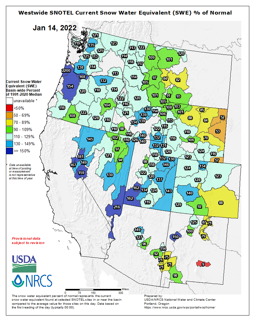
Fortunately, a weeklong series of snowstorms between Christmas and New Year’s dumped several feet on the San Juan Mountains, causing snowpack averages to jump from around 80% to more than 140%, according to data from the National Resource Conservation Service.

Unfortunately, these numbers don’t tell the whole story of Colorado’s snowpack. This year, Colorado, as well as the entire West, is basing snowpack averages on updated numbers that reflect the drier years the West has been experiencing because of climate change-driven drought.

True, the updated snowpack averages are important for researchers and hydrologists in their work to better understand current climate conditions. The problem for some, however, is that by continually calling degraded conditions from climate change “normal,” both scientists and the public adjust their sense of normal to a situation that is anything but.

“It mutes the effects of climate change because we’re constantly shifting the baseline to reflect the new normal,” Michael Remke, a lecturer of biology at Fort Lewis College, said. “If we become normalized to it being dry, and then we have a dry year reported as 120% of normal, then people are like, ‘Great, a wet year.’ But the reality is we’re trending in a dry direction.”

[…]

The National Resource Conservation Service calculates “historic averages” of snowpack based on a 30-year period of record (mostly through SNOTEL stations in the high country). These are updated every 10 years to reflect the most current conditions.

For the past 10 years, however, these averages have been based on snowfall recorded from 1981-2010. But as of this October, the data set was updated to include snowpack averages from 1991-2020. Essentially, the data set switched out the 1980s (considered a wet period) to include the 2010s (a very dry period).

The updated numbers make sense for snow researchers and scientists working in related fields, said Joel Atwood, a hydrologist for NRCS’s Colorado Snow Survey. “It’s important to capture changes as we move forward. When you have 30-year intervals, you can capture some of those changes, and the last chunk of 30 years are more comparable to present conditions.”

One of the most important uses for the data is to monitor and predict runoff in the spring – a critical piece of information to gauge how much water may be available for municipalities, agriculture and other uses…

What’s normal?

The problem, some believe, is that the new snowpack averages are shared through social media or the nightly news, and the full context and nuances of the data is not well understood by the public.

For Southwest Colorado, the baselines from 1981-2010 are below the standards now in effect from 1991-2020. This early in the winter, there’s no great disparity between the two for snowpack averages. But that could change come peak season in April, when the snowpack on Red Mountain Pass is an inch below the water-snow equivalent from previous standards. In other areas, the changes are more drastic…

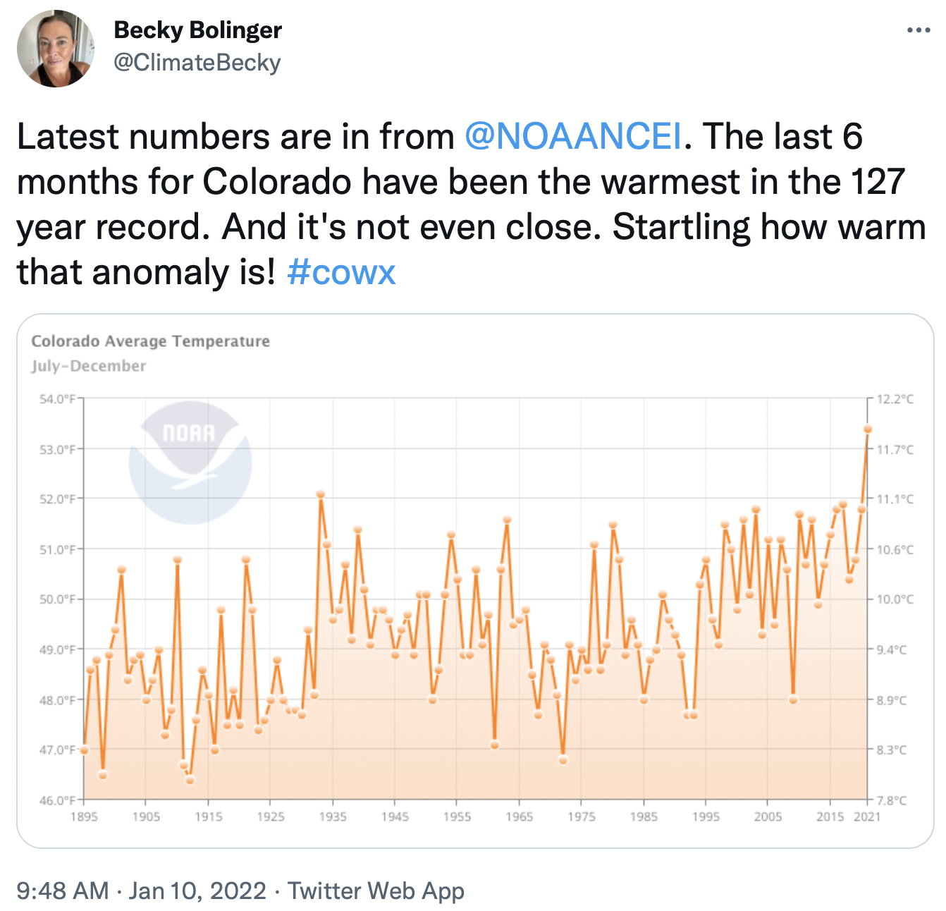
Snowpack isn’t the only data set updated every 10 years. Various agencies, like the USGS and NOAA, also update things like temperature and precipitation norms every decade. But the wrench of the impacts from climate change are increasingly complicating how to interpret and use all this information…

A shifting baseline

This issue is no new phenomena – in fact it has a name: shifting baseline syndrome.

Also known as SBS, it was first coined in 1995 after a scientist studying what would be a sustainable catch level for commercial fishing found each generation of fishery scientists used the current conditions as their baselines, not taking into account the degradation that had occurred from past over-fishing.

“The shifting baseline syndrome is the situation in which, over time, knowledge is lost about the state of the natural world, because people don’t perceive changes that are actually taking place,” Dr. E.J. Milner-Gulland, who authored a paper on SBS, said in 2009. “In this way, people’s perceptions of change are out of kilter with the actual changes taking place in the environment.”

[…]

Skewing reality

The new snowpack averages are a relatively small piece of the puzzle, but it does warp our reference point, Remke said, because the newer data reflects drier years that are now the new standard. “This is an important issue to be aware of,” he said.

The situation grows ever more complicated when taking into account the tools and technology for measuring snowpack (there’s a lot of variability in numbers, methods, etc.). And with only 700 or so SNOTEL sites across the West, mostly installed in the 1980s, data is limited.

But, according a report in Forbes, some climate scientists are urging agencies to stick with a 30-year time period, rather than update the standards every decade and reinforce shifting baselines. And, a report on SBS said it could be combated by environmental restoration, increased data collection, education and quite simply, having more people interact with nature.

All this is important to think about, Burke said: Basing snowpack data on the past 30 years will likely yield more accurate predictions of next year’s snowpack, and may make us feel better about this year’s numbers. But it will also obscure the seriousness of the drought in which we currently find ourselves.

Aspinall Unit update report — #GunnisonRiver #ColoradoRiver #COriver #aridification

From email from Reclamation (Erik Knight):

Storms boost #snowpack amid persistent #drought — The #Montrose Daily Press #GunnisonRiver #ColoradoRiver #SanJuanRiver #DoloresRiver #COriver #aridification

Colorado snowpack basin-filled map January 13, 2022 via the NRCS.

From The Montrose Daily Press (Katharhynn Heidelberg):

Although Montrose finished 2021 a bit below normal for overall precipitation — 7.55 inches compared to the “normal year” average of 8.28 inches — December’s monthly precip, at 0.67 inches, was above the 0.46 inches average usually seen.

“There were two significant events in December that were the lion’s share of that,” National Weather Service meteorologist Lucas Boyer said on Jan. 6.

On Dec. 9, a snowstorm brought 0.22 inches of moisture and on New Year’s Eve came another 0.21 inches…

Last week carried 0.8 inches of precip for Montrose, a shade above the normal of 0.7. One week isn’t sufficient to determine how the whole month might go, but it left Montrose “pretty much even” with where it should be…

The Colorado River District isn’t counting anything as a certainty, but is breathing a little easier because of increased snowpack.

The January 10 SNOTEL data show the Gunnison Basin at 146% of normal snow-water equivalent.

In considering the relatively wet year of 2019, [Zane] Kessler said it would take about 10 such years to truly turn things around.

“That’s not a good bet. We’re not likely to see a solution to the structural deficit anytime soon,” he said.

The last round of storms did, however, help, taking extra-parched basins like the San Miguel, Dolores, Animas and San Juan to 134% of average.

Westwide SNOTEL basin-filled map January 14, 2022 via the NRCS.

#Colorado had hottest six months in history, new data shows: The next highest average temperatures came during the 1930s Dust Bowl — The #Loveland Reporter-Herald

Green Mountain Reservoir. Photo credit: Colorado Parks & Wildlife

From The Denver Post (Conrad Swanson) via The Loveland Reporter-Herald:

The average temperature for the last six months is the hottest recorded in Colorado and the country as a whole, according to data released this week by the National Oceanic and Atmospheric Administration.

The next-highest six-month average temperature peak in Colorado came during the 1930s Dust Bowl era, the data shows.

Colorado, and the rest of the country is unlikely to see an exact repeat of the Dust Bowl because we’re able to manage the land better than during the 1930s, Climatologist Becky Bolinger of Colorado State University said. But there are some similarities in the extreme temperatures, abnormally dry climate and the dust storm that swept from Colorado to the Midwest last month.

“We are currently experiencing climate change,” Bolinger said. “It’s not something that happens in the future. We have it happening now.”

The federal data shows that the average temperature in Colorado between July and December of 2021 reached 53.4 degrees, more than a degree and a half warmer than the same six-month span in 2020.

The next highest six-month average in Colorado came in 1933 at 52.1 degrees, the only other time in the state’s record when that average exceeded 52 degrees, the data shows.

Nationally, the six-month average hit 59.77 degrees last year, more than a full degree higher than during the same period in 2020, the data shows. The next closest peak nationally came in 2015, when the six-month average reached 59.32 degrees. The national July-December average has only exceeded 59 degrees in 1998, 2015, 2016 and last year.

Relatively speaking the average temperature increase, in Colorado and across the country, might appear slight but it makes a large difference, Bolinger said. Higher temperatures lead to more moisture and water lost into dry soils or to evaporation.

Those dry conditions elongate the state’s wildfire season (which many experts now describe as year-round) and increase the amount of fuel that can exacerbate the fires once they start.

New Research Advocates Basic Strategy for Native Fish Recovery: Access to #Water — #Utah State University

Threatened and endangered native fish of the Colorado River need access to the most basic of resources for recovery — adequate natural streamflow, according to new research. (Photo courtesy Nate Cathcart)

From Utah State University (Lael Gilbert):

Rivers need water — a fact that may seem ridiculously obvious, but in times of increasing water development, drought and climate change, the quantity of natural streamflow that remains in river channels is coming into question, especially in the Colorado River basin. Newly published research from Utah State University poses a tough question in these days of falling reservoir levels and high-stakes urban development: whether the continued development of rivers for water supply can be balanced with fish conservation.

Historically, the Colorado River basin has been highly dynamic with a wide range of streamflow, river temperatures and large sediment loads. Native fish evolved through periods of wet and dry cycles. But water-supply development has depleted the flow of many rivers in the Upper and Lower Colorado River basins, and today’s river habitats are increasingly decoupled from the natural cycle of spring snowmelt, monsoon-season floods and intervening low flows in favor of development and for stocking nonnative sports fish.

The health and recovery of native fish species now depends largely on the public’s willingness to protect rivers that retain some semblance of a natural flow regime as freshwater conservation areas, say authors Casey Pennock, Phaedra Budy, Wally Macfarlane and Jack Schmidt of the Watershed Sciences Department in the S. J. and Jessie E. Quinney College of Natural Resources and colleagues.

“Most people who study or manage fishes know that complex habitat required by native fish is created and maintained by adequate river flows, or a natural flow regime,” said Budy. “Nonetheless, society continues to manage our desert rivers as if we think that fish don’t need water. If we continue down this path, we will watch native fishes, some of which are found nowhere else on Earth, blink off the planet.”

Graphic via Holly McClelland/High Country News.

Dams have changed the natural flow in many rivers in the Colorado River basin, but a more pressing problem is the depletion of flow such that little water remains in the channel. At a regional scale, water in the Colorado River basin is completely consumed and no water reaches the Gulf of California in most years. Even in the Upper Colorado River basin, some streams, such as the Duchesne, Price and San Rafael Rivers are nearly completely depleted of natural flow. If there is not enough flow in the river, other conservation efforts for native fish don’t really matter, say the authors.

Endangered fish recovery programs are designed not to interfere with existing or proposed future water development. The task of recovering endangered native fish populations may be an impossible goal wherever natural streamflow is declining due to a warming climate and wherever consumptive water uses are increasing, according to the authors. Despite decadeslong efforts by state, federal, tribal and private organizations, some native fish can’t maintain self-sustaining populations in the Colorado River basin today, and some species would be extinct without federal stocking programs.

“Managing for the minimum amount of water necessary to sustain native fish during dry spells is a common approach, but there are not many places where this strategy is sufficient to recover and protect native fish. We think conservation of natural flows is critical for long-term conservation of fish,” Pennock said. “In some rivers there have been attempts to recreate the benefits of natural flow with managed releases from large dams to reduce the negative downstream impacts of water development. These kinds of actions can have some localized benefit, but they are not likely to help native fish long-term or large-scale.”

Schmidt, who also directs Utah State’s Center for Colorado River Studies, stressed the importance of action.

“This study reminds us that increasing consumptive water use in an era of declining natural streamflow inevitably jeopardizes one of the Colorado River’s most distinctive attributes — its endemic native fishery,” Schmidt said. “If we care about protecting natural river ecosystems, then we as a society are going to have to care about leaving significant amounts of water in our rivers.”

#Colorado Governor Polis is warning he will “protect and aggressively assert” his state’s #water rights after #Nebraska Governor Pete Ricketts announced a plan to spend $500 million on a canal and reservoir project — CBS #Denver #SouthPlatteRiver

The Platte River is formed in western Nebraska east of the city of North Platte, Nebraska by the confluence of the North Platte and the South Platte Rivers, which both arise from snowmelt in the eastern Rockies east of the Continental Divide. Map via Wikimedia.

From the CBS Denver Youtube channel:

Colorado’s governor is warning he will “protect and aggressively assert” his state’s water rights after Nebraska Gov. Pete Ricketts announced a plan to spend $500 million on a canal and reservoir project.

From Omaha World-Herald (Nancy Gaarder) via The Lincoln Journal-Star:

Colorado Gov. Jared Polis said Wednesday that his state would work to protect its water rights in light of Nebraska’s proposal to build a canal in his state to pull water from the South Platte River.

In a statement, Polis said Colorado would “protect and aggressively assert Colorado’s rights under all existing water compacts.”

[…]

Ricketts said the canal is needed because Colorado is planning “nearly 300 projects and over $10 billion of expenditures to ensure no ‘excess’ water leaves its state.”

If those proposals are carried out, Ricketts estimates, there would be a 90% reduction in flows coming into Nebraska.

Polis said Ricketts’ comments reflect a “misunderstanding of Colorado’s locally driven water planning projects.”

[…]

Polis said Colorado has used roundtable discussions to generate grassroots ideas for solutions to Colorado’s water needs. These brainstorming ideas “should not be taken as formally approved projects.”

[…]

Colorado, he said, has complied with the South Platte Compact for its 99 years and continues to respect the agreement. “We hope that our partners in Nebraska will show they share that respect.”

In response, Ricketts issued a statement saying he “welcomes future conversations with Gov. Polis as we move forward to secure Nebraska’s access to water.”

Any project involving U.S. waterways typically faces rigorous scrutiny. Polis said any project by Nebraska in Colorado would have to comply with the compact, private property rights, state and federal laws and regulations, including environmental ones.

#Louisville main #water system cut off to avoid contamination — #Colorado Hometown Weekly #MarshallFire

This is the oldest known photo of Louisville. In this beautiful image you are looking west on Spruce Steet from Main Street and can see the Flatirons in the hazy distance. This photo provides an amazing feel of how wide open the spaces were between the new cities on the front range. Photo via DowntownLouisville.com.

From Colorado Hometown Weekly (Ella Cobb):

While neighboring Superior deals with water odor and smell issues, a number of residents in Louisville are reporting no running water at all.

According to a City of Louisville website update on Thursday, a high number of homes within or close to the Marshall Fire burn area were cut off from Louisville’s main water system in order to avoid contamination following the fire.

The city is working alongside the Colorado Department of Public Health and Environment to monitor the water quality level and ensure that when water returns to homes that it’s safe to use.

In order to keep residents up to date on testing measures, the city’s Public Works Department created an interactive map that reflects current water sample testing activity.

Places on the map that read “sample compliant” indicates that the water in the area has tested negative for chlorine, bacteria or volatile organic compounds, and that chlorine residuals in the water are between 0.2 and 4.0 mg/L, which is the national drinking water standard.

While tests are ongoing, the city has provided bulk water tanks for residents to use while water reinstatement is pending. One is located at North Washington Avenue and Arapahoe Circle, with another one at Owl Drive and Pinyon Way. The Recreation Center, located at 900 Via Appia Way, is offering free showers and bottled water to affected residents.