The health of our waters is the principal measure of how we live on the land — Luna Leopold
#Drought news (January 27, 2022): Topsoil moisture rated at least one-half very short to short in #Colorado (82%), #KS (77%), #NE (73%), and #WY (60%)
Click on a thumbnail graphic to view a gallery of drought data from the US Drought Monitor.
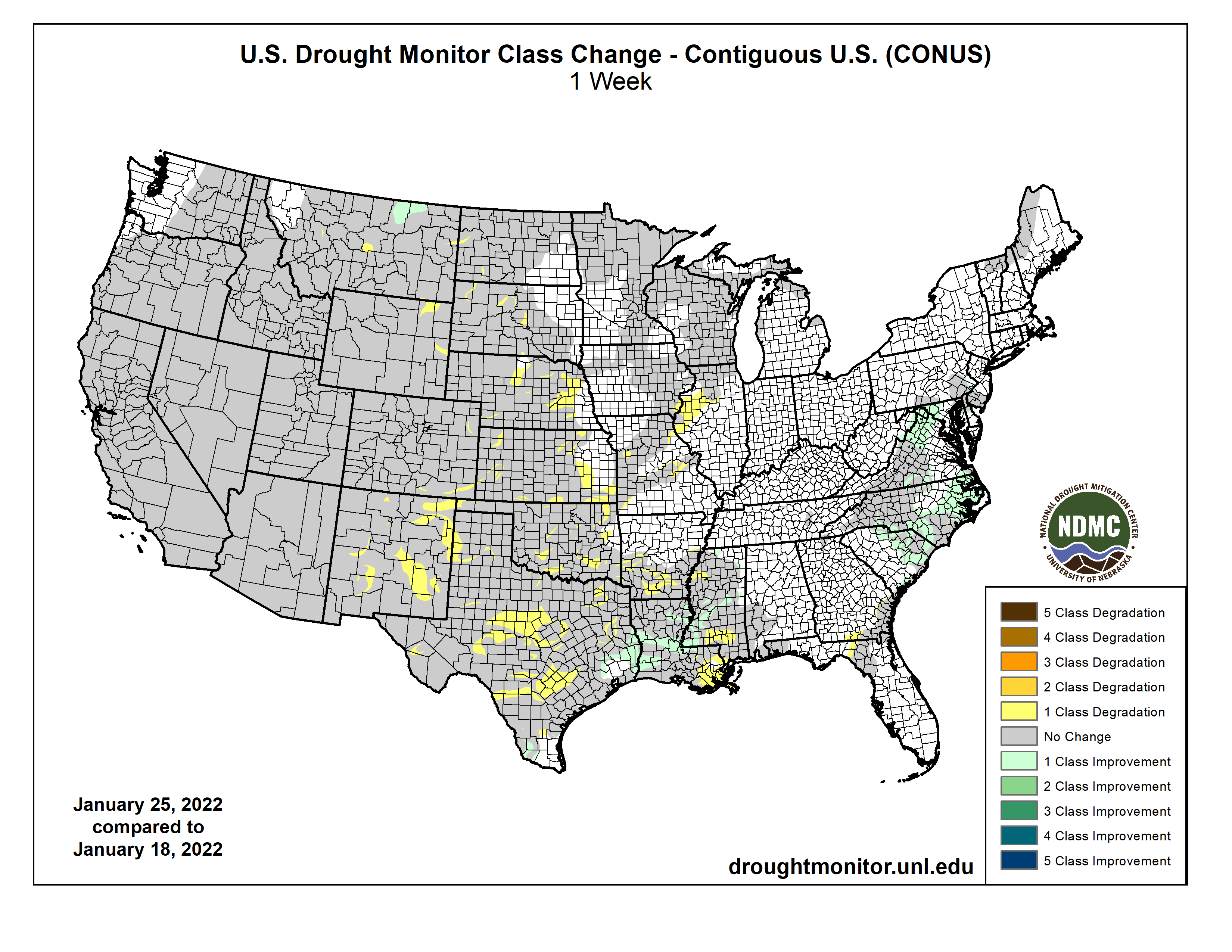
US Drought Monitor map January 25, 2022.
High Plains Drought Monitor map January 25, 2022.
West Drought Monitor map January 25, 2022.
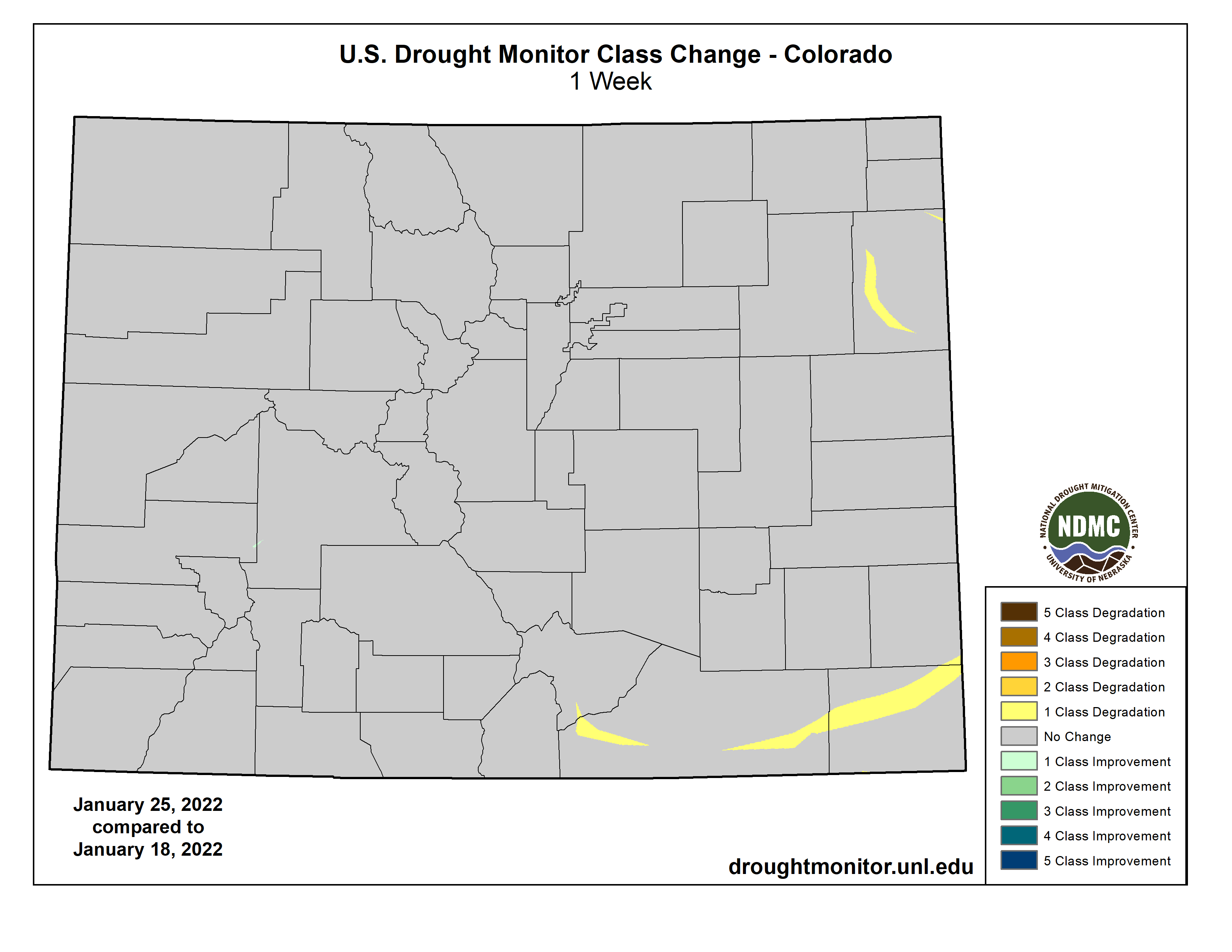
Drought monitor Colorado Drought Monitor map January 25, 2022.
Click here to go to the US Drought Monitor website. Here’s an excerpt:
This Week’s Drought Summary
As the drought-monitoring period began on January 18, a moisture-laden storm had just cleared the Atlantic Coast States. A few days later, another system delivered a variety of weather, including rain, freezing rain, sleet, and snow, across parts of the South. The latter storm produced significant snow on January 21-22 near the middle Atlantic Coast, including eastern North Carolina and southeastern Virginia. Most of the remainder of the country experienced a dry week, aside from periods of mostly light precipitation from the Pacific Northwest to the Great Lakes States. However, completely dry weather prevailed through January 24 in several areas, including California and the parched southern Plains, where 71 percent of Texas’ winter wheat was rated in very poor to poor condition. As the drought-monitoring period ended early January 25, some snow developed on the northern and central High Plains, while rain returned along and near the Gulf Coast. Elsewhere, frigid conditions from the Midwest into the Northeast and generally chilly conditions across the eastern half of the country contrasted with near- or above-normal temperatures farther west…
Despite some snow on the High Plains late in the drought-monitoring period, the general theme was toward gradually worsening drought conditions, especially in Kansas and Nebraska. U.S. Department of Agriculture statistics from January 23 reflected some of the issues being faced by farmers, with topsoil moisture rated at least one-half very short to short in Colorado (82%), Kansas (77%), Nebraska (73%), and Wyoming (60%). In addition, at least one-quarter of the winter wheat was rated very poor to poor on that date in Kansas (31%), Wyoming (33%), Colorado (40%). Even in the Dakotas, where some drought recovery has occurred in recent months, topsoil moisture was greater than 40% very short to short. In addition, stock water supplies in North Dakota were reported to be 50% very short to short…
Colorado Drought Monitor one week change map ending January 25, 2022.
Much of the region has experienced alternating periods of wet and dry weather since the Water Year began on October 1, 2021. For example, a wet October was followed by a warm, dry November; an exceptionally stormy December; and a mild, dry January. As the West moves into the second half of its winter wet season, a return to stormy weather will be needed to sustain the drought improvement that occurred during October and December. According to the California Department of Water Resources, the water equivalency of the Sierra Nevada snowpack increased less than an inch (from 15.4 to 16.0 inches) between December 30 and January 26, with the corresponding percent of average for the date falling from 160 to 103%. Compared to normal values, snow-water equivalency was appreciably lower (less than two-thirds of average in several river basins) across the eastern slopes of the Rockies, especially in eastern Wyoming and much of New Mexico, resulting is some drought deterioration. In New Mexico, topsoil moisture was rated 87% very short to short on January 23, according to the U.S. Department of Agriculture, while stock water supplies were 49% very short to short. With the recent dryness, compounded by long-term drought issues and warm, windy weather, a rare January wildfire—the 700-acre Colorado Fire—erupted near Big Sur, California, on January 21…
Locally heavy rain delivered some drought relief from southeastern Texas to central Mississippi, but largely bypassed other areas of the South. In fact, worsening drought conditions were noted across the southern Great Plains, including large sections of Oklahoma and Texas. Some of the most significant Southern rain fell on January 19-20, when totals approached, reached, or exceeded 2 inches in locations such as Houston, Texas (1.98 inches), and Vicksburg, Mississippi (2.06 inches). Additional rain fell across the Deep South on January 24-25. Farther north and west, however, drought broadly worsened, with exceptional drought (D4) expanding slightly in western Oklahoma. On January 23, according to the U.S. Department of Agriculture, topsoil moisture was rated 81% very short to short in Oklahoma and 64% very short to short in Texas. On the same date, winter wheat was rated 71% very poor to poor in Texas, along with 43% in Oklahoma. Just 3 months ago, in late-November 2021, those numbers stood at 45 and 16% very poor to poor, respectively. Worsening drought on the Plains has also contributed to several mid-winter wildfires; a few, including the Mill Creek Fire in Shackleford County, Texas—which was ignited on January 15—torched more than 1,000 acres of brush and grass. Burn bans were in effect for dozens of counties in Oklahoma and Texas…
Looking Ahead
During the next 5 days, the only major storm system to affect the country will develop near the southern Atlantic Coast and move northward. The potential exists for significant accumulations of wind-driven snow, starting Friday night and continuing into the weekend, from the middle Atlantic Coast into New England. Most of the remainder of the country will receive little or no precipitation, although exceptions during the next couple of days will include rain from southern Texas to Florida’s peninsula and snow squalls downwind of the Great Lakes. In addition, precipitation should begin to overspread the Northwest during the weekend. Elsewhere, frigid conditions will linger during the next several days from the Midwest into the Northeast, while areas as far south as Florida’s peninsula may experience sub-freezing temperatures as January draws to a close. The NWS 6- to 10-day outlook for February 1 – 5 calls for the likelihood of above-normal temperatures in the eastern U.S., while colder-than-normal conditions will prevail along and west of a line from central Texas to Lake Michigan. Meanwhile, below-normal precipitation in the Far West, including northern and central California and the Great Basin, should contrast with wetter-than-normal weather in most areas from the central and southern Rockies to the Atlantic Coast.
US Drought Monitor one week change map ending January 25, 2022.