The health of our waters is the principal measure of how we live on the land — Luna Leopold
#Drought news (January 6, 2022): Some improvement in western #Colorado
Click on a thumbnail graphic to view a gallery of drought data from the US Drought Monitor.
US Drought Monitor map January 4, 2022.
High Plains Drought Monitor map January 4, 2022.
West Drought Monitor map January 4, 2022.
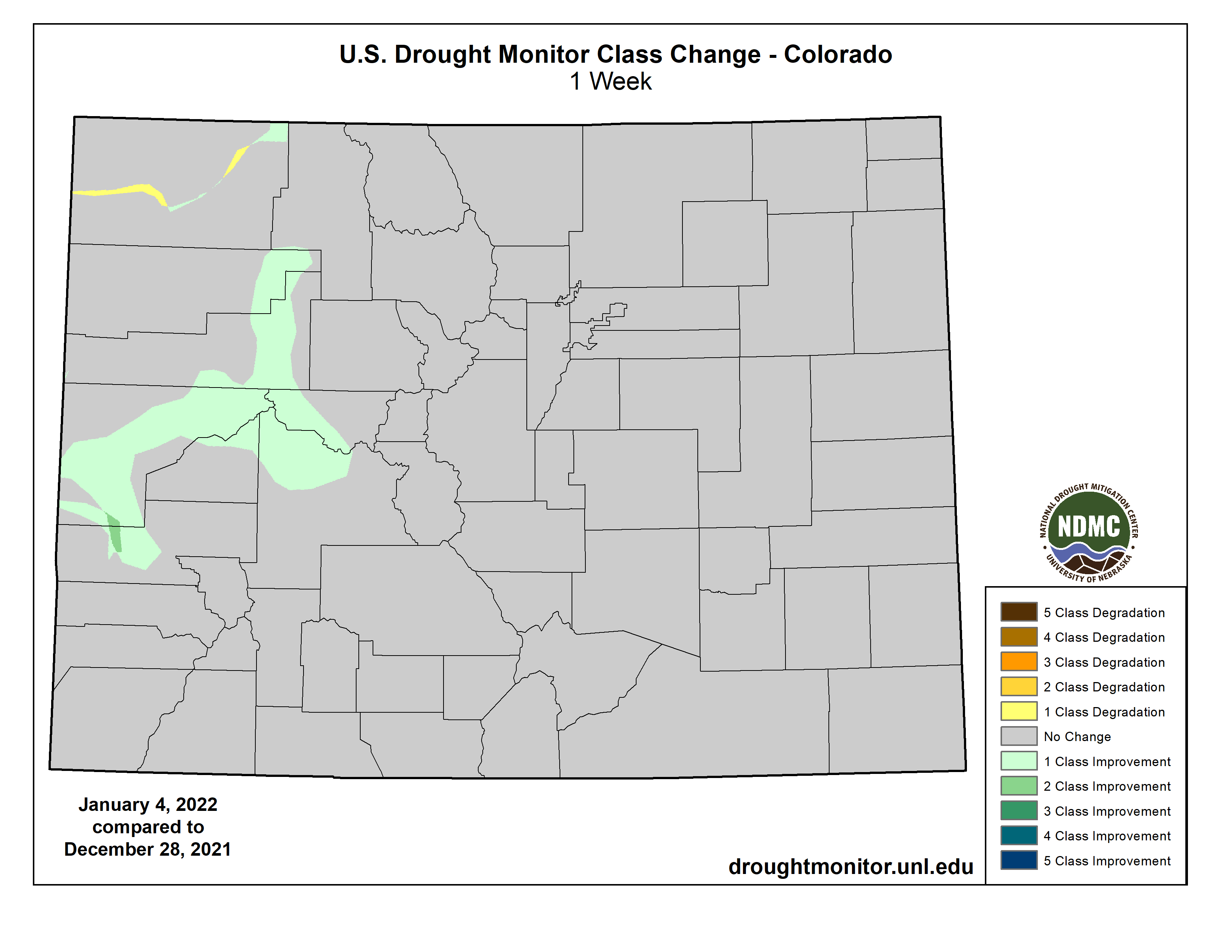
Colorado Drought Monitor map January 4, 2022.
Click here to go to the US Drought Monitor website. Here’s an excerpt:
This Week’s Drought Summary
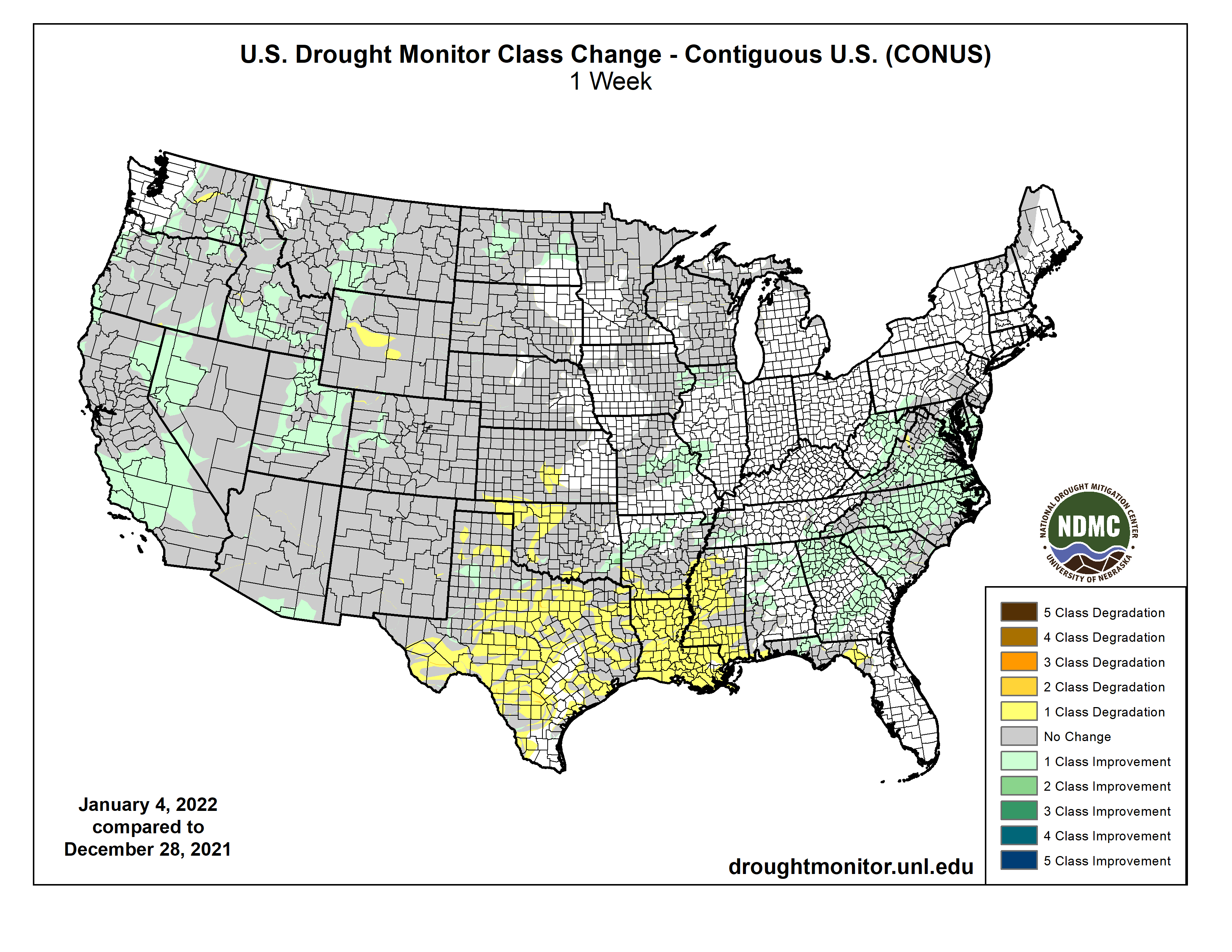
In what has become a familiar pattern, heavy precipitation continued to improve drought and dryness across the northern half of the West Coast States, though it created its own set of significant impacts. Farther south, similar totals fell on a relatively small area in southwest California. Heavy precipitation – some falling as heavy snow – also covered areas from the Ohio Valley and Middle Atlantic States southward through the Tennessee Valley, the interior Southeast, and the Carolinas. Parts of the Rockies – primarily the higher elevations – also reported moderate to heavy precipitation. Meanwhile, only light precipitation fell on the Northeast, across much of the lower Midwest, and along most of the Gulf Coast and adjacent areas. Most of the Plains and upper Mississippi Valley reported little or no precipitation. The result was some significant areas of drought improvement across the Carolinas and interior Southeast, as well as parts of the West Coast States and Rockies. In contrast, unseasonably warm and dry weather for several weeks prompted fairly broad areas of deterioration along the immediate central Gulf Coast, the southwestern half of the lower Mississippi Valley, and the southern Plains…
It was a dry week east of the Rockies, and even across Colorado and Wyoming, moderate to heavy precipitation was limited to the higher elevations. This was sufficient to prompt some improvement in western Colorado and a small section in northwestern Wyoming. The eastern portions of D0 and D1 areas in North Dakota were also improved based on a re-assessment of reduced impacts from earlier precipitation. Meanwhile, southern Kansas saw some deterioration near Oklahoma, where the last 60 days brought very little precipitation. But given it is the coldest and climatologically driest time of year there, deterioration was limited to a patch in the southernmost reaches of Kansas where the weather has been somewhat warmer. Central Wyoming also saw worsening conditions where little or no precipitation fell during the last 60 days…
Colorado Drought Monitor one week change map ending January 4, 2022.
Heavy precipitation and a generous snowpack in mountainous areas led to more improvement here, based in part on monthly statistics for December. Improvement was brought into large swaths of the region, especially across central Montana, much of Idaho and Utah, western Nevada, and part of central and southern California. It was a wet week with 2 to locally 6 inches of precipitation reported from the Cascades westward to the Coast in the Pacific Northwest and adjacent parts of California, further reducing dryness and drought in areas where such conditions have already been removed. Some areas in California already received more precipitation in the last 3 months than they had in the prior 12 months…
Eastern Tennessee – as with adjacent parts of the Southeast Region – reported at least 3 inches of rain, with as much as 6 inches in isolated spots. Farther west, less-widespread 2 to 4 inch amounts extended across northern Arkansas and adjacent Oklahoma. As a result, improvement occurred in many esixting areas of D0, keeping most of the northern tier of this Region drought-free and limiting D0 to some areas near the Mississippi-Ohio Rivers confluence, and interior eastern Tennessee. In stark contrast, several weeks of unseasonably warm weather and aubnormal precipitation led to broad deteriorations across the southern half of the Region from Mississippi and Louisiana westward through significant portions of Texas. Over the last 2 months, precipitation totals were 4 to 8 inches below normal from eastern Teas through Louisiana into central Mississippi, leading to widespread D1 to and D2 across central Mississippi, northern Louisiana, and eastern Texas while D0 expanded southward to cover areas from central Louisiana and Mississippi all the way to the Gulf Coast. Farther west across central and western portions of Texas and Oklahoma, deterioration was not as widespread and there were some small scattered areas of improvement, However, most of central and western Texas, the Texas and Oklahoma Panhandles, and central Oklahoma recorded 25 percent of normal precipitation or less for the past 60 days…
Looking Ahead
January 5-9, 2022 could benefit some of the recently-expanded areas of dryness and drought near the Gulf Coast. 0.5 to 1.0 inch is forecast along the Coast from the western Florida Panhandle through most of southeastern Louisiana, with amounts potentially topping 1.5 inches farther west into the northeastern Texas Coast. Farther north, moderate to heavy precipitation – including some substantial snowfall – should reach from the Lower Mississippi Valley through the upper Southeast, the central and southern Appalachians, and (to a lesser extent) the Middle Atlantic States. Between 1.5 and 2.5 inches of precipitation will impact a swath extending from northeastern parts of the Lower Mississippi Valley eastward into the southern Appalachians. Moderate precipitation should extend as far north as the immediate Ohio Valley, as far east as the Middle Atlantic Coast, and as far southeast as non-coastal areas of the Carolinas and Georgia. Heavy precipitation and some heavy snows should continue to whittle away at dryness and drought in the Pacific Northwest, although it will probably bring a different set of problems. Areas west of the Washington Cascades will be most significantly impacted, with most locations recording several inches (liquid equivalent) of precipitation. Several areas extending from the Idaho Panhandle and adjacent areas southeastward into central Colorado will also see moderate precipitation, especially in the Idaho Panhandle (1.5 to locally 3.5 inches) and higher elevations in Wyoming and Colordao. Other parts of the 48-states will see much less precipitation. Light to moderate precipitation (generally 0.5 to 1.0 inch) is expected across the Northeast, with little or none falling along the Southeast Coast and most of Florida, the Plains, and the southwestern quarter of the Nation. Temperatures will remain well below normal from the Upper Midwest through most of Montana, averaging 9 to 15 deg. F below normal. Near-normal temperatures will cover the Northeast and Middle Atlantic States while unseasonable warmth prevails along the southern tier of the country and in the Four Corners Region.
The Climate Prediction Center’s 6-10 day outlook (valid Jan 10-15, 2022) favors subnormal precipitation across most of the 48-states, with odds favoring above-normal precipitation limited to a swath from the southern Rockies to the Lower Mississippi Valley. Meanwhile, above-normal temperatures are favored near the Gulf Coast (especially Florida), the Plains, most of the Rockies, and the immediate West Coast.
US Drought Monitor one week change map ending January 4, 2022.
Just for grins here’s a gallery of early January US Drought Monitor maps for the past few years.