The Bureau of Land Management kicks off great outdoors month with two acquisitions through the land and water conservation fund: Acquisitions in Colorado and Wyoming significantly increase access to public lands

Known for its breathtaking scenery, the Dominguez-Escalante National Conservation Area is a fine example of the spectacular canyon country of Colorado’s Uncompahgre Plateau. Red-rock canyons and sandstone bluffs hold geological and paleontological resources spanning 600 million years, as well as many cultural and historic sites. The Ute Tribes today consider these pinyon-juniper–covered lands an important connection to their ancestral past. The Escalante, Cottonwood, Little Dominguez and Big Dominguez Creeks cascade through sandstone canyon walls that drain the eastern Uncompahgre Plateau. Unaweep Canyon on the northern boundary of the NCA contains globally significant geological resources. Nearly 30 miles (48 km) of the Gunnison River flow through the Dominguez-Escalante NCA, supporting fish, wildlife and recreational resources. The Old Spanish National Historic Trail, a 19th Century land trade route, also passes through it. A variety of wildlife call the area home, including desert bighorn sheep, mule deer, golden eagle, turkey, elk, mountain lion, black bear, and the collared lizard. There are 115 miles (185 km) of streams and rivers in the NCA, and there is habitat suitable for 52 protected species of animals and plants. By Bob Wick; Bureau of Land Management – Dominguez-Escalante NCA, Public Domain, https://commons.wikimedia.org/w/index.php?curid=42092807

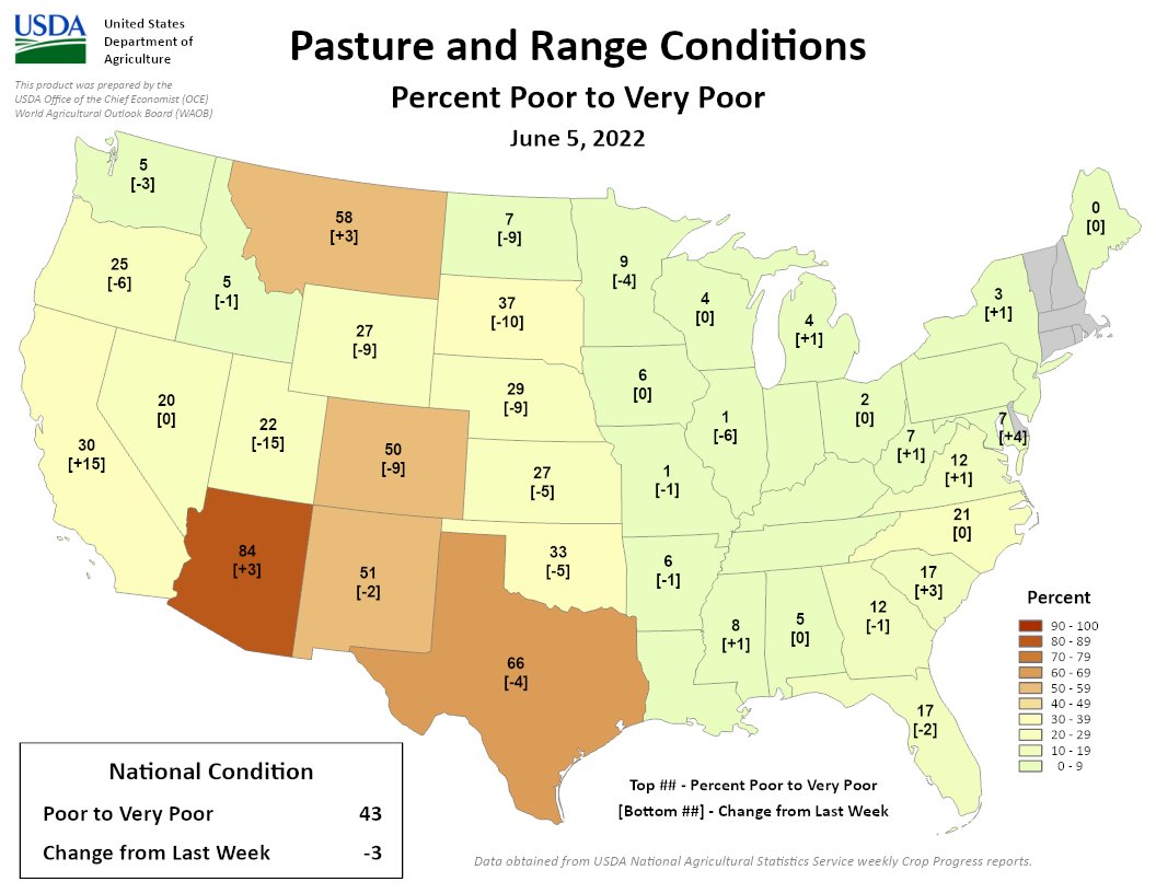
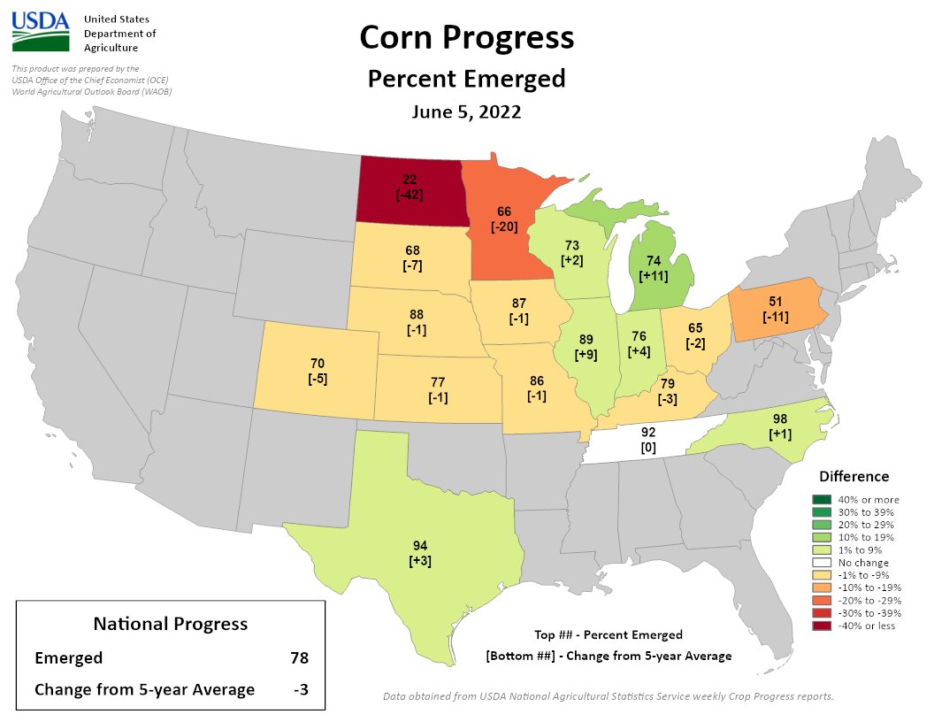
Click the link to read the release on the Bureau of Land Management website:

The Bureau of Land Management is kicking off Great Outdoors Month by finalizing two land acquisitions in Colorado and Wyoming that will unlock over 40,000 acres of previously inaccessible public land.

In partnership with The Conservation Fund, a national nonprofit that supports the voluntary protection of public lands and waters, the Bureau of Land Management finalized two acquisitions through the Land and Water Conservation Fund: the 160-acre Escalante Creek Parcel within the Dominguez-Escalante National Conservation Area in Colorado, and 35,670 acres of private land southwest of Casper, Wyoming that will unlock access to 40,000 acres of existing BLM and State of Wyoming land.

“The BLM works hard to provide additional access to previously inaccessible public lands by working with partner organizations like The Conservation Fund and through the Land and Water Conservation Fund,” said BLM Director Tracy Stone-Manning. “We are so grateful for these partnerships that allow us to conserve and expand access to public lands for many generations to come.”

Marton Property Acquisition

The BLM Wyoming acquisition is the largest land purchase that the BLM has undertaken in Wyoming, creating a 118-square-mile contiguous block of public land and improving public access to the North Platte River.

The Conservation Fund worked closely with the Marton family to acquire the property, and recently transferred it to the BLM for permanent protection using funding from the Land and Water Conservation Fund. The Conservation Fund’s initial purchase was also supported by a grant from the Rocky Mountain Elk Foundation. Congress provided funding to acquire the ranch over several years, and BLM received $21 million from the Land and Water Conservation Fund in 2021 to purchase the ranch in its entirety.

Located east of Alcova Reservoir, the Marton property is bordered to the north by 8.8 miles of North Platte River frontage and extends south into Carbon County. Acquisition of the property will connect formerly inaccessible BLM and State lands and ensure the continued conservation of important wildlife habitat for Greater Sage-Grouse, raptors, and big game species. The property’s proximity to Casper and ease of access furthers the Department of the Interior’s commitment to ensuring equitable access to America’s lands and waters.

“This acquisition marks a big step forward for improving public access,” said BLM High Plains District Manager Kevin Christensen. “Through our lasting partnership with The Conservation Fund, we have a unique opportunity to conserve crucial wildlife habitat at a landscape scale and expand access to the river and public land for our local community and visitors.”

The inclusion of an additional 8.8 miles of public access to the North Platte River, a blue-ribbon trout fishery boasting more pounds per mile of fish than any other stream in Wyoming, provides growth opportunities for the tourism and recreation economy in Casper and Natrona County. In 2021, travelers spent $285.1 million in Natrona County, generating $16.3 million in state and local taxes.

The acquired lands will be managed initially the same as adjoining BLM-managed lands, with existing decisions in place that protect wildlife habitats and other resources while promoting recreation. The BLM will undertake a planning effort to develop management prescriptions specific to the area that take into account the purposes of the Land and Water Conservation Fund and the input of Tribes, partner agencies, and the public.

“Ensuring a conservation solution like this one requires not just an outstanding landscape, but outstanding private citizens and public servants to match it,” said Dan Schlager, Wyoming state director at The Conservation Fund. “Thanks to the truly exceptional land management and determination of the Marton family, and an unwavering problem-solving commitment from the BLM, this remarkable landscape will remain permanently conserved for the enjoyment of the entire Wyoming community.”

Dominguez-Escalante National Conservation Area

The Dominguez-Escalante National Conservation Area, located in canyon country of the Uncompahgre Plateau in Western Colorado, is part of the BLM’s National Conservation Lands system. It is designated as an Area of Critical Environmental Concern, Watchable Wildlife Area, and Special Recreation Management Area. The parcel being transferred includes about a half-mile of Escalante Creek, which is home to three sensitive fish species and provides a popular whitewater kayaking destination. The creek is also an important tributary to the nearby Gunnison River. The lands are used for recreation activities like camping, fishing, and kayaking and contain essential wildlife habitats for desert bighorn sheep and mule deer.

“This acquisition in Colorado allows the BLM to permanently protect and enhance the cultural, recreational, and wildlife resources in Escalante Canyon for the benefit and enjoyment of present and future generations,” said Collin Ewing, Dominguez-Escalante National Conservation Area Manager. “We appreciate our continued partnerships with The Conservation Fund and the local community that allows us to improve equitable access on our public land.”

The Conservation Fund worked with the former owners of the 160-acre Escalante Creek property to find a permanent conservation solution for their land that will secure public access, improve recreational opportunities, and preserve ecosystem benefits for the local communities.

“Increasing recreational access to the spectacular red-rock canyons in the Dominguez-Escalante National Conservation Area is a great addition to the public lands that belong to all of us,” said Kelly Ingebritson of The Conservation Fund’s Colorado office. “We appreciate the leadership of the BLM, Colorado’s Congressional delegation, the landowners, and local supporters to protect a strategic treasure on Escalante Creek and in the heart of the National Conservation Area.”

“We are proud to see this land protected for public access and future generations,” said Paul Felin, former landowner, and representative for the family who owned the parcel. “The property’s portion of Escalante Creek is a wonderful recreation area that our family and friends enjoyed visiting since the 1970s, which the public will now be able to experience going forward under the BLM’s ownership.”

Click the link to read the “BLM acquires 160-acre parcel on Escalante Creek” on The Grand Junction Daily Sentinel website (Dennis Webb). Here’s an excerpt:

The Bureau of Land Management has acquired a 160-acre private parcel of land along Escalante Creek southwest of Delta, in the Dominguez-Escalante National Conservation Area, using Land and Water Conservation Fund money. The land now in public hands includes about a half-mile of the creek. The acquisition occurred with the help of the nonprofit Conservation Fund, which worked with the property’s former owners to find a permanent conservation solution for the land to secure public access, improve recreational opportunities and preserve ecosystem benefits, the BLM said in a news release.

A Conservation Fund fact sheet on the acquisition indicates it’s being made possible with the help of $480,000 in federal fiscal year 2022 Land and Water Conservation Fund dollars. The fund derives its revenues from federal offshore oil and gas leasing. It receives $900 million a year in permanent funding because of a bill passed by Congress in 2020. The Conservation Fund fact sheet says the acquisition is intended to permanently protect what had been a private inholding within the National Conservation Area.

It is accessible by a county road and is southwest and upstream of the Escalante Potholes Recreation Site. The acquisition will provide new access for camping, fishing and other recreation in a creek corridor also popular for whitewater boating during spring runoff season. The property also provides important wildlife habitat for species such as mule deer and desert bighorn sheep, and protecting it helps protect three sensitive fish species in the creek.

The latest briefing is hot off the presses on the Western #Water Assessment website (June 5, 2022 – CO, UT, WY)

Click the link to read the briefing on the Western Water Assessment website:

La Niña continued to influence regional weather during May with cooler than average temperatures throughout most of the region and above average precipitation for northern Wyoming. June 1st SWE was much above normal in much of Wyoming, near normal in northern Colorado and east of the Continental Divide and generally below normal or completely melted in Utah. June 1st seasonal streamflow forecasts were below to much-below normal for the Upper Colorado River and Great Basins. While drought remains present in 92% of the region, drought conditions significantly improved in northern Wyoming, but worsened in Utah and southern Colorado.

May precipitation was generally below normal in the Intermountain West. The driest conditions were observed in southern Utah and southwest Colorado where many locations saw no measurable precipitation. May precipitation was above normal in northwestern Wyoming, central Wyoming and locations along the Continental Divide in Colorado. Due to mostly below normal May temperatures, many mid-to-high elevation locations saw significant snowfall.

Regional temperatures were near-to-below normal during May. In northern Utah, northwestern Colorado and western Wyoming, temperatures were 2-4 degrees below normal.

June 1st snow water equivalent (SWE) was generally above normal in the northern portion of the region and completely melted out or below normal in southwestern Colorado and southern Utah. Near normal June 1st SWE was observed in northern Colorado, northern Utah and southern Wyoming despite below average May 1st SWE in many of these locations. In much of Wyoming, June 1st SWE conditions ranged from 126% – 705% of normal. Improvements in June SWE conditions compared to May1st SWE conditions were due to below normal temperatures and areas of much above average precipitation.

June 1st seasonal streamflow forecasts are below to much-below normal in the Upper Colorado River and Great Basins. Seasonal runoff forecasts were highest, but still below normal, for the Upper Colorado, Upper Gunnison, and Upper Yampa River basins. Seasonal runoff forecasts are much-below normal for all other river basins. Many locations in Utah and western Colorado, where temperatures were near normal and precipitation was below normal, dust storms caused significant dust accumulation on snowpack and speeded melt. Inflow forecasts for all major regional reservoirs are much-below normal with Green Mountain (79% normal) and Blue Mesa (68%) Reservoirs faring best and Lake Powell, Flaming Gorge, McPhee and Navajo Reservoirs are forecasted to have less than 55% normal inflow volumes.

Drought conditions continue across 92% of the region. Overall, drought conditions improved in the northern portion of the region and deteriorated in the south. Cooler and wetter conditions led to a two-category improvement of drought conditions in northern Wyoming and a large decrease in the coverage of extreme (D3) drought. D3 drought developed in southwestern Wyoming during May. Drought conditions worsened in western Colorado with the emergence of D1 drought along the Colorado River and expansion of D2 and D3 drought. Drought was removed in portions of Larimer and Routt Counties in northern Colorado. In Utah, D3 drought emerged over large areas of the state, now covering 72% of its area.

West Drought Monitor map May 31, 2022.

La Niña conditions continued during May with eastern Pacific Ocean temperatures averaging 1ºC below normal. La Niña conditions are expected to persist at least through June and there is a greater than 50% probability of La Niña continuing through early winter. A typical La Niña weather pattern is forecasted to continue during June with a higher probability of wetter and cooler than normal conditions for northern Wyoming. The NOAA seasonal forecast for June-August predicts a 60-70% probability of above average temperatures for most of the region and an increased probability of below normal precipitation for Wyoming, most of Colorado and northern Utah. There is an increased probability of above average summer precipitation in southern Arizona, suggesting the possibility of a stronger than normal monsoon.

Despite recent snow, high fire danger continues in the #SanLuisValley The Ark Valley Voice #RioGrande

Click the link to read the article on the Ark Valley Voice website (Jan Wondra). Here’s an excerpt:

While Chaffee and Fremont counties have been released (temporarily) from fire restrictions, such is not the case in San Luis Valley. The entire San Luis Valley is under fire restrictions. The Saguache County Office of Emergency Management is urging residents to prepare for wildfire…

The three National Weather Service offices in Colorado issued 62 red-flag warnings in April — the most since record-keeping began in 2006. Snowpack levels were well below average with the San Luis Valley recording less than half of its normal levels, according to the USDA’s Natural Resources Conservation Center…

Drought is expected to persist well into the summer according to the National Integrated Drought Information System. Models from the National Weather Service’s Climate Prediction Center also suggest the coming months will be warmer and much drier than normal across Colorado. Above normal significant fire potential is expected to continue from June through September according to the National Interagency Fire Center.

Paper: Interbasin and interhemispheric impacts of a collapsed Atlantic Overturning Circulation — Nature #ClimateChange #ActOnClimate

Topographic map of the Nordic Seas and subpolar basins with surface currents (solid curves) and deep currents (dashed curves) that form a portion of the Atlantic meridional overturning circulation. Colors of curves indicate approximate temperatures. By R. Curry, Woods Hole Oceanographic Institution/Science/USGCRP. – http://editors.eol.org/eoearth/wiki/File:OCP07_Fig-6.jpg, CC BY 3.0, https://commons.wikimedia.org/w/index.php?curid=61272315

Click here to access the paper on the Nature website (Bryam Orihuela-Pinto, Matthew H. England & Andréa S. Taschetto). Here’s the abstract:

Climate projections suggest a weakening or collapse of the Atlantic Meridional Overturning Circulation (AMOC) under global warming, with evidence that a slowdown is already underway. This could have significant ramifications for Atlantic Ocean heat transport, Arctic sea ice extent and regional North Atlantic climate. However, the potential for far-reaching effects, such as teleconnections to adjacent basins and into the Southern Hemisphere, remains unclear. Here, using a global climate model we show that AMOC collapse can accelerate the Pacific trade winds and Walker circulation by leaving an excess of heat in the tropical South Atlantic. This tropical warming drives anomalous atmospheric convection, resulting in enhanced subsidence over the east Pacific and a strengthened Walker circulation and trade winds. Further teleconnections include weakening of the Indian and South Atlantic subtropical highs and deepening of the Amundsen Sea Low. These findings have important implications for understanding the global climate response to ongoing greenhouse gas increases.

Click the link to read “A huge Atlantic ocean current is slowing down. If it collapses, La Niña could become the norm for Australia” on The Conversation website (Matthew England, Andréa S. Taschetto & Bryam Orihuela-Pinto):

Shutterstock

Matthew England, UNSW Sydney; Andréa S. Taschetto, UNSW Sydney, and Bryam Orihuela-Pinto, UNSW Sydney

Climate change is slowing down the conveyor belt of ocean currents that brings warm water from the tropics up to the North Atlantic. Our research, published today in Nature Climate Change, looks at the profound consequences to global climate if this Atlantic conveyor collapses entirely.

We found the collapse of this system – called the Atlantic meridional overturning circulation – would shift the Earth’s climate to a more La Niña-like state. This would mean more flooding rains over eastern Australia and worse droughts and bushfire seasons over southwest United States.

East-coast Australians know what unrelenting La Niña feels like. Climate change has loaded our atmosphere with moister air, while two summers of La Niña warmed the ocean north of Australia. Both contributed to some of the wettest conditions ever experienced, with record-breaking floods in New South Wales and Queensland.

Meanwhile, over the southwest of North America, a record drought and severe bushfires have put a huge strain on emergency services and agriculture, with the 2021 fires alone estimated to have cost at least US$70 billion.

Earth’s climate is dynamic, variable, and ever-changing. But our current trajectory of unabated greenhouse gas emissions is giving the whole system a giant kick that’ll have uncertain consequences – consequences that’ll rewrite our textbook description of the planet’s ocean circulation and its impact.

What is the Atlantic overturning meridional circulation?

The Atlantic overturning circulation comprises a massive flow of warm tropical water to the North Atlantic that helps keep European climate mild, while allowing the tropics a chance to lose excess heat. An equivalent overturning of Antarctic waters can be found in the Southern Hemisphere.

Climate records reaching back 120,000 years reveal the Atlantic overturning circulation has switched off, or dramatically slowed, during ice ages. It switches on and placates European climate during so-called “interglacial periods”, when the Earth’s climate is warmer.

Since human civilisation began around 5,000 years ago, the Atlantic overturning has been relatively stable. But over the past few decades a slowdown has been detected, and this has scientists worried.

The main components of the Atlantic meridional overturning circulation. The northward flowing upper branch (red arrow) transports warm salty waters to the North Atlantic, and forms the North Atlantic Deep Waters (NADW) at high latitudes. The southward flowing NADW lies above the Antarctic Bottom Water (AABW).
Stefano Crivellari, University of São Paulo/Research Gate

Why the slowdown? One unambiguous consequence of global warming is the melting of polar ice caps in Greenland and Antarctica. When these icecaps melt they dump massive amounts of freshwater into the oceans, making water more buoyant and reducing the sinking of dense water at high latitudes.

Around Greenland alone, a massive 5 trillion tonnes of ice has melted in the past 20 years. That’s equivalent to 10,000 Sydney Harbours worth of freshwater. This melt rate is set to increase over the coming decades if global warming continues unabated.

A collapse of the North Atlantic and Antarctic overturning circulations would profoundly alter the anatomy of the world’s oceans. It would make them fresher at depth, deplete them of oxygen, and starve the upper ocean of the upwelling of nutrients provided when deep waters resurface from the ocean abyss. The implications for marine ecosystems would be profound.

With Greenland ice melt already well underway, scientists estimate the Atlantic overturning is at its weakest for at least the last millennium, with predictions of a future collapse on the cards in coming centuries if greenhouse gas emissions go unchecked.

The ramifications of a slowdown

In our study, we used a comprehensive global model to examine what Earth’s climate would look like under such a collapse. We switched the Atlantic overturning off by applying a massive meltwater anomaly to the North Atlantic, and then compared this to an equivalent run with no meltwater applied.

Our focus was to look beyond the well-known regional impacts around Europe and North America, and to check how Earth’s climate would change in remote locations, as far south as Antarctica.

An Atlantic overturning shutdown would be felt as far south as Antarctica.
Shutterstock

The first thing the model simulations revealed was that without the Atlantic overturning, a massive pile up of heat builds up just south of the Equator.

This excess of tropical Atlantic heat pushes more warm moist air into the upper troposphere (around 10 kilometres into the atmosphere), causing dry air to descend over the east Pacific.

The descending air then strengthens trade winds, which pushes warm water towards the Indonesian seas. And this helps put the tropical Pacific into a La Niña-like state.

Australians may think of La Niña summers as cool and wet. But under the long-term warming trend of climate change, their worst impacts will be flooding rain, especially over the east.

We also show an Atlantic overturning shutdown would be felt as far south as Antarctica. Rising warm air over the West Pacific would trigger wind changes that propagate south to Antarctica. This would deepen the atmospheric low pressure system over the Amundsen Sea, which sits off west Antarctica.

This low pressure system is known to influence ice sheet and ice shelf melt, as well as ocean circulation and sea-ice extent as far west as the Ross Sea.

A new world order

At no time in Earth’s history, giant meteorites and super-volcanos aside, has our climate system been jolted by changes in atmospheric gas composition like what we are imposing today by our unabated burning of fossil fuels.

The oceans are the flywheel of Earth’s climate, slowing the pace of change by absorbing heat and carbon in vast quantities. But there is payback, with sea level rise, ice melt, and a significant slowdown of the Atlantic overturning circulation projected for this century.

Now we know this slowdown will not just affect the North Atlantic region, but as far away as Australia and Antarctica.

We can prevent these changes from happening by growing a new low-carbon economy. Doing so will change, for the second time in less than a century, the course of Earth’s climate history – this time for the better.The Conversation

Matthew England, Scientia Professor and Deputy Director of the ARC Australian Centre for Excellence in Antarctic Science (ACEAS), UNSW Sydney; Andréa S. Taschetto, Associate Professor, UNSW Sydney, and Bryam Orihuela-Pinto, PhD Candidate, UNSW Sydney

This article is republished from The Conversation under a Creative Commons license. Read the original article.

Ice world: Antarctica’s riskiest glacier is under assault from below and losing its grip — The Conversation #ActOnClimate


The front of Thwaites Glacier is a jagged, towering cliff.
David Vaughan/British Antarctic Survey

Ted Scambos, University of Colorado Boulder

Flying over Antarctica, it’s hard to see what all the fuss is about. Like a gigantic wedding cake, the frosting of snow on top of the world’s largest ice sheet looks smooth and unblemished, beautiful and perfectly white. Little swirls of snow dunes cover the surface.

But as you approach the edge of the ice sheet, a sense of tremendous underlying power emerges. Cracks appear in the surface, sometimes organized like a washboard, and sometimes a complete chaos of spires and ridges, revealing the pale blue crystalline heart of the ice below.

As the plane flies lower, the scale of these breaks steadily grows. These are not just cracks, but canyons large enough to swallow a jetliner, or spires the size of monuments. Cliffs and tears, rips in the white blanket emerge, indicating a force that can toss city blocks of ice around like so many wrecked cars in a pileup. It’s a twisted, torn, wrenched landscape. A sense of movement also emerges, in a way that no ice-free part of the Earth can convey – the entire landscape is in motion, and seemingly not very happy about it.

A view across the ice from an airplane showing many fractures.
Broken ice where Thwaites Glacier heads out to sea.
Ted Scambos

Antarctica is a continent comprising several large islands, one of them the size of Australia, all buried under a 10,000-foot-thick layer of ice. The ice holds enough fresh water to raise sea level by nearly 200 feet.

Its glaciers have always been in motion, but beneath the ice, changes are taking place that are having profound effects on the future of the ice sheet – and on the future of coastal communities around the world.

Breaking, thinning, melting, collapsing

Antarctica is where I work. As a polar scientist I’ve visited most areas of the ice sheet in more than 20 trips to the continent, bringing sensors and weather stations, trekking across glaciers, or measuring the speed, thickness and structure of the ice.

Currently, I’m the U.S. coordinating scientist for a major international research effort on Antarctica’s riskiest glacier – more on that in a moment. I have gingerly crossed crevasses, trodden carefully on hard blue windswept ice, and driven for days over the most monotonous landscape you can imagine.

Mountains direct the flow of glaciers toward the sea.
66 North via Unsplash

For most of the past few centuries, the ice sheet has been stable, as far as polar science can tell. Our ability to track how much ice flows out each year, and how much snow falls on top, extends back just a handful of decades, but what we see is an ice sheet that was nearly in balance as recently as the 1980s.

Early on, changes in the ice happened slowly. Icebergs would break away, but the ice was replaced by new outflow. Total snowfall had not changed much in centuries – this we knew from looking at ice cores – and in general the flow of ice and the elevation of the ice sheet seemed so constant that a main goal of early ice research in Antarctica was finding a place, any place, that had changed dramatically.

Deep cracks leaves jagged columns of ice with a layer of snow at the top ready to tip into the sea.
Ice breaks off the front of a glacier in Antarctica.
66 North via Unsplash
A map of the ice sheet showing faster flowing ice at the ice shelves and particularly around the edges of West Antarctica.
A map of Antarctica seen from above, most of it the ice sheet, shows the velocity of the ice flow ice. Thwaites Glacier is on the left.
NASA’s Goddard Space Flight Center Scientific Visualization Studio

But now, as the surrounding air and ocean warm, areas of the Antarctic ice sheet that had been stable for thousands of years are breaking, thinning, melting, or in some cases collapsing in a heap. As these edges of the ice react, they send a powerful reminder: If even a small part of the ice sheet were to completely crumble into the sea, the impact for the world’s coasts would be severe.

Like many geoscientists, I think about how the Earth looks below the part that we can see. For Antarctica, that means thinking about the landscape below the ice. What does the buried continent look like – and how does that rocky basement shape the future of the ice in a warming world?

Visualizing the world below the ice

Recent efforts to combine data from hundreds of airplane and ground-based studies have given us a kind of map of the continent below the ice. It reveals two very different landscapes, divided by the Transantarctic Mountains.

In East Antarctica, the part closer to Australia, the continent is rugged and furrowed, with several small mountain ranges. Some of these have alpine valleys, cut by the very first glaciers that formed on Antarctica 30 million years ago, when its climate resembled Alberta’s or Patagonia’s. Most of East Antarctica’s bedrock sits above sea level. This is where the city-size Conger ice shelf collapsed amid an unusually intense heat wave in March 2022.

A view of Antarctica's bedrock beneath the ice today shows islands in the west side and more above-sea bedrock in the east.
Below the ice, recent studies have mapped Antarctica’s bedrock and show much of the west side is below sea level.
Bedmap2; Fretwell 2013

In West Antarctica the bedrock is far different, with parts that are far deeper. This area was once the ocean bottom, a region where the continent was stretched and broken into smaller blocks with deep seabed between. Large islands made of volcanic mountain ranges are linked together by the thick blanket of ice. But the ice here is warmer, and moving faster.

As recently as 120,000 years ago, this area was probably an open ocean – and definitely so in the past 2 million years. This is important because our climate today is fast approaching temperatures like those of a few million years ago.

The realization that the West Antarctic ice sheet was gone in the past is the cause of great concern in the global warming era.

Early stages of a large-scale retreat

Toward the coast of West Antarctica is a large area of ice called Thwaites Glacier. This is the widest glacier on earth, at 70 miles across, draining an area nearly as large as Idaho.

Satellite data tell us that it is in the early stages of a large-scale retreat. The height of the surface has been dropping by up to 3 feet each year. Huge cracks have formed at the coast, and many large icebergs have been set adrift. The glacier is flowing at over a mile per year, and this speed has nearly doubled in the past three decades.

Two decades of satellite data show the fastest ice loss in the vicinity of the Thwaites Glacier. NASA.
A view across the ice from an airplane showing many fractures.
From above, fractures are evident in the Thwaites Glacier.
Ted Scambos

This area was noted early on as a place where the ice could lose its grip on the bedrock. The region was termed the “weak underbelly” of the ice sheet.

Some of the first measurements of the ice depth, using radio echo-sounding, showed that the center of West Antarctica had bedrock up to a mile and a half below sea level. The coastal area was shallower, with a few mountains and some higher ground; but a wide gap between the mountains lay near the coast. This is where Thwaites Glacier meets the sea.

This pattern, with deeper ice piled high near the center of an ice sheet, and shallower but still low bedrock near the coast, is a recipe for disaster – albeit a very slow-moving disaster.

Ice flows under its own weight – something we learned in high school earth science, but give it a thought now. With very tall and very deep ice near Antarctica’s center, a tremendous potential for faster flow exists. By being shallower near the edges, the flow is held back – grinding on the bedrock as it tries to leave, and having a shorter column of ice at the coast squeezing it outward.

An Antarctic glacier flows between mountains. Lines in ice show that it's flowing.
An Antarctic glacier flows toward the sea.
Erin Pettit
How warmer water is undermining the glacier.

If the ice were to step back far enough, the retreating front would go from “thin” ice – still nearly 3,000 feet thick – to thicker ice toward the center of the continent. At the retreating edge, the ice would flow faster, because the ice is thicker now. By flowing faster, the glacier pulls down the ice behind it, allowing it to float, causing more retreat. This is what’s known as a positive feedback loop – retreat leading to thicker ice at the front of the glacier, making for faster flow, leading to more retreat.

Warming water: The assault from below

But how would this retreat begin? Until recently, Thwaites had not changed a lot since it was first mapped in the 1940s. Early on, scientists thought a retreat would be a result of warmer air and surface melting. But the cause of the changes at Thwaites seen in satellite data is not so easy to spot from the surface.

Beneath the ice, however, at the point where the ice sheet first lifts off the continent and begins to jut out over the ocean as a floating ice shelf, the cause of the retreat becomes evident. Here, ocean water well above the melting point is eroding the base of the ice, erasing it as an ice cube would disappear bobbing in a glass of water.

An illustration of an ice shelf and glacier with water flowing under the ice shelf and eroding it at the seabed
Warming water is reaching under the ice shelf and eroding it from below.
Scambos et al 2017

Water that is capable of melting as much as 50 to 100 feet of ice every year meets the edge of the ice sheet here. This erosion lets the ice flow faster, pushing against the floating ice shelf.

The ice shelf is one of the restraining forces holding the ice sheet back. But pressure from the land ice is slowly breaking this ice plate. Like a board splintering under too much weight, it is developing huge cracks. When it gives way – and mapping of the fractures and speed of flow suggests this is just a few years away – it will be another step that allows the ice to flow faster, feeding the feedback loop.

Up to 10 feet of sea level rise

Looking back at the ice-covered continent from our camp this year, it is a sobering view. A huge glacier, flowing toward the coast, and stretching from horizon to horizon, rises up to the middle of the West Antarctic Ice Sheet. There is a palpable feeling that the ice is bearing down on the coast.

Ice is still ice – it doesn’t move that fast no matter what is driving it; but this giant area called West Antarctica could soon begin a multicentury decline that would add up to 10 feet to sea level. In the process, the rate of sea level rise would increase severalfold, posing large challenges for people with a stake in coastal cities. Which is pretty much all of us.The Conversation

Ted Scambos, Senior Research Scientist, CIRES, University of Colorado Boulder

This article is republished from The Conversation under a Creative Commons license. Read the original article.