The Colorado River Compact turns 100 this year, but any celebration is damped down by the drying-up of the big reservoirs it enabled. The Bureau of Reclamation’s “first-ever” shortage declaration on the river acknowledges officially what we’ve known for years: the Compact and all the measures augmenting it, collectively known as The Law of the River, have not prevented the river’s over-development.
Nearly every pronouncement from the water establishment about the centennial of the Colorado River Compact calls it the “foundation,” “the cornerstone” of the Law of the River – as though before the Compact was adopted, the river was lawless.
It wasn’t. The real foundation of the Law of the River is the appropriation doctrine that all seven river basin states embraced from their start, an evolving body of common law foundational to all water development in the arid American West.
There is much to appreciate in the appropriation doctrine. It allows water to be claimed only by those who are actually putting it to beneficial use, thus precluding speculation. It protects existing downstream users from having their supply dried up by new upstream users. It has shown flexibility in incorporating new uses.
But the appropriation doctrine also evolved as a powerful engine for growth. Its “first in time, first in right” promise of perpetual secure use rewards those who get to the water first.
Map credit: AGU
Judicial decisions then increased its potential for spurring growth. The abstract “right to use water” came to be a property right that could be bought and sold like an automobile, and water whose use was so purchased could then be moved anywhere – along with its seniority. This enabled cities and other large entities with concentrated economic power to buy and move water far from its origin, including water they were not yet ready to use, which clashed with the appropriation doctrine’s anti-speculation intent.
The Colorado River Compact commission came together 100 years ago to impose some control on that growth engine. The seven Basin states had finally acknowledged that they would have to honor each other’s prior appropriations, and they knew that could precipitate a chaotic seven-state horse race, with each state trying to appropriate as much water as possible as quickly as possible.
Their initial strategy was to prevent that by determining what each state could “equitably” use. That failed because the cumulative sum of what they each believed they deserved added up to considerably more than the river’s average flow.
Finally, they just divided the seven-state horserace into three-state and four-state horse races, details to be worked out later, and that became the essence of the Compact. It wasn’t quite what they had set out to do, but it satisfied the federal government enough to allow Reclamation’s eager beavers to begin developing the river’s mainstem.
The Compact and subsequent laws, agreements, contracts and other measures we know as The Law of the River impose public priorities on the Upper and Lower Basins, limit water for California, designate water for Mexico, add recreation as a beneficial use, incorporate environmental restrictions, limit California again, construct shell games with reservoirs, et cetera.
But a good question for evaluating the Compact and the Law of the River today is this: Would the situation on the Colorado River today have been any worse, or different, had there been no Colorado River Compact and its augmenting “Law of the River”?
Brad Udall: Here’s the latest version of my 4-Panel plot thru Water Year (Oct-Sep) of 2021 of the Colorado River big reservoirs, natural flows, precipitation, and temperature. Data (PRISM) goes back or 1906 (or 1935 for reservoirs.) This updates previous work with @GreatLakesPeck.
Given that the desert empire watered by the Colorado River continues to grow virtually unchecked, with 50 to 80 percent more growth anticipated by mid-century, even as the water supply shrinks four to five percent for every degree of temperature increase, it may be time to stop trying to construct control systems around the growth engine, and look into the engine itself.
This is, of course, something no one wants to touch. But what can else be done when an appropriation doctrine has nothing left to appropriate and the growth it enables has become dollar-driven and spiraling out of control?
George Sibley as the Water Buffalo in “Sonofagunn.” Photo courtesy of the Gunnison Arts Center via the Upper Gunnison River Water Conservancy District
George Sibley is a contributor to Writers on the Range, http://writersontherange.org, an independent nonprofit dedicated to spurring lively discussion about Western issues. He writes extensively about the Colorado River.
Colorado has just enacted a statewide turf replacement incentive program. So, what does this mean for water conservation? WRA’s Laura Belanger joined us to explain the benefits for Colorado’s communities and water security.
Vail has begun methodically removing grass from its parks from areas that serve little purpose, partly with the goal of saving water. Buffehr Creek Park after xeriscaping. Photo: Town of Vail
Liza Mitchell, a natural resource planner and ecologist with Pitkin County, stands near the wetlands on the North Star Nature Preserve on Aug. 26. A restoration project aims to keep water in the fen, which is habitat for many kinds of wildlife, including ducks, plovers and moose. Photo credit: Heather Sackett/Aspen Journalism
Colorado Parks and Wildlife (CPW) is pleased to announce the Colorado Wildlife Habitat Program (CWHP) 2022 Request for Proposals (RFP). The CWHP is a statewide program that supports CPW’s mission by offering funding opportunities to private or public landowners who wish to protect wildlife habitat on their property, and/or provide wildlife-related recreational access to the public.
The CWHP is an incentive-based program that funds conservation easements, public access easements, and fee title purchases to accomplish strategic wildlife conservation and public access goals.
Funding for the 2022 cycle is approximately $11 million and is made possible by revenue generated from the sale of the Habitat Stamp, hunting and fishing licenses, and through CPW’s partnership with Great Outdoors Colorado (GOCO).
To Apply
The landowner or a third party representative must complete application forms which address one or more of the following CPW’s 2022 funding priorities:
Public access for hunting, fishing, wildlife viewing
Big game winter range and migration corridors
Protecting habitat for species of concern (specifically those Species of Greatest Conservation Need, as identified in the Colorado Parks and Wildlife Statewide Action Plan)
Riparian areas and wetlands
Landscape-scale parcels and parcels that provide connectivity to conserved lands
2022 funding preferences include working farms and ranches and properties adjacent to wildlife crossings. Application materials will be available on Monday, June 13, 2022 here: https://cpw.state.co.us/cwhp.
All proposals must be received by 5 p.m. on Thursday, October 13, 2022.
Completed applications are to be emailed to: Wildlife.RealEstateProposals(at)state.co.us.
Applicants will receive a confirmation email acknowledging receipt.
The CWHP funds conservation easements held by CPW or qualified third parties. Third parties may submit a proposal on behalf of the landowner and applications must be signed by the landowner(s). It is strongly recommended that applicants contact the CWHP manager before submitting an application.
Additional Information
CPW recognizes that maintaining wildlife-compatible agriculture on the landscape is an important benefit that can be achieved through conservation easements and land management plans. All conservation easements funded through the CWHP will require a management plan. The plan must be agreed upon by the landowner and CPW prior to closing, and may include provisions for the type, timing, and duration of livestock grazing, recreational activities, and overall management of wildlife habitat.
Landowners are encouraged to develop a clear vision for the future of the property prior to submitting a proposal. Proposals are scored and ranked through a rigorous review process to evaluate strategic conservation impacts, biological significance, public benefits, and project feasibility. Local CPW staff can help describe the wildlife and habitat values accurately. Local CPW office contact information may be found here: https://cpw.state.co.us/learn/Maps/CPW_Areas.pdf.
Initial funding recommendations will be deliberated in March 2023. Final decisions on which projects will move forward is expected to be determined at the Parks and Wildlife Commission’s May 2023 meeting.
All conservation easement properties are required by law to be monitored annually. Third Party conservation easement holders will be required to submit to CPW copies of the annual monitoring report for each conservation easement funded through the CWHP.
Public access is not required for all conservation easement projects, but compensation is available for granting wildlife-related public access to CPW. Landowners are welcome to submit proposals for projects where the sole purpose is to provide hunting or fishing access through a public access easement, without an associated conservation easement.
Under Colorado law, terms of the transaction become a matter of public record after the project is completed and closed. Additionally, it is important for CPW and major funding partners to provide accurate information to the public regarding the CWHP’s efforts to protect vital habitats and provide hunting and fishing access opportunities. Applicants should be aware that after a project has closed, information about the transaction, including funding amounts, may be used by CPW for internal planning and public information purposes.
All CWHP real estate transactions are subject to an appraisal and an appraisal review to verify value. Applicants are strongly encouraged to consult their legal and financial advisors when contemplating any real estate transaction associated with the CWHP.
Contact Information
For additional information about the CWHP or application process, please contact: Amanda Nims, CWHP Manager
Colorado Parks and Wildlife, Real Estate Section 6060 Broadway
Denver, CO 80216
(303) 291-7269
Amanda.nims@state.co.us
A few days ago The Times published a report on the drying up of the Great Salt Lake, a story I’m ashamed to admit had flown under my personal radar. We’re not talking about a hypothetical event in the distant future: The lake has already lost two-thirds of its surface area, and ecological disasters — salinity rising to the point where wildlife dies off, occasional poisonous dust storms sweeping through a metropolitan area of 2.5 million people — seem imminent.
A comparison of the Aral Sea in 1989 (left) and 2014 (right). Credit: NASA. Collage by Producercunningham. [Public domain], via Wikimedia Commons.
As an aside, I was a bit surprised that the article didn’t mention the obvious parallels with the Aral Sea, a huge lake that the Soviet Union had managed to turn into a toxic desert.
In any case, what’s happening to the Great Salt Lake is pretty bad. But what I found really scary about the report is what the lack of an effective response to the lake’s crisis says about our ability to respond to the larger, indeed existential threat of climate change.
If you aren’t terrified by the threat posed by rising levels of greenhouse gases, you aren’t paying attention — which, sadly, many people aren’t. And those who are or should be aware of that threat but stand in the way of action for the sake of short-term profits or political expediency are, in a real sense, betraying humanity. That said, the world’s failure to take action on climate, while inexcusable, is also understandable. For as many observers have noted, global warming is a problem that almost looks custom-designed to make political action difficult. In fact, the politics of climate change are hard for at least four reasons.
First, when scientists began raising the alarm in the 1980s, climate change looked like a distant threat — a problem for future generations. Some people still see it that way; last month a senior executive at the bank HSBC gave a talk in which he declared, “Who cares if Miami is six meters underwater in 100 years?”
[…]
…the second problem with climate change: It’s not yet visible to the naked eye, at least the naked eye that doesn’t want to see.
Weather, after all, fluctuates. Heat waves and droughts happened before the planet began warming; cold spells still happen even with the planet warmer on average than in the past. It doesn’t take fancy analysis to show that there is a persistent upward trend in temperatures, but many people aren’t convinced by statistical analysis of any kind, fancy or not, only by raw experience.
Then there’s the third problem: Until recently, it looked as if any major attempt to reduce greenhouse gas emissions would have significant economic costs. Serious estimates of these costs were always much lower than claimed by anti-environmentalists, and spectacular technological progress in renewable energy has made a transition to a low-emission economy look far easier than anyone could have imagined 15 years ago. Still, fears about economic losses helped block climate action.
Leaf charging in Frisco September 30, 2021.
Finally, climate change is a global problem, requiring global action — and offering a reason not to move. Anyone urging U.S. action has encountered the counterargument, “It doesn’t matter what we do, because China will just keep polluting.” There are answers to that argument — if we ever do get serious about emissions, carbon tariffs will have to be part of the mix. But it’s certainly an argument that affects the discussion.
Click the link to read the article on the InkStain website (Eric Kuhn and John Fleck):
With a single statement, the United States Supreme Court changed the direction and tone of the compact negotiations:
“[T]he waters of an innavigable stream rising in one state and flowing into a state adjoining may not be disposed of by the upper state as she may choose, regardless of the harm that may ensue to the lower state and her citizens.”
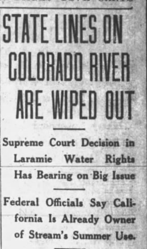
In a unanimous ruling, on June 5, 1922, the court issued its decision in Wyoming v. Colorado, ruling that Colorado could not develop waters of the Laramie River in a manner that ignored and injured downstream senior appropriators in Wyoming.
Salt Lake Tribune, June 8, 1922 via InkStain
The decision, and its clear implications for the development of the Colorado River, echoed around the West. “State Lines on Colorado River Are Wiped Out”, blared a front page headline in the Salt Lake Tribune, adding “Federal Officials Say California is Already Owner of Stream’s Summer Use.”
This was the risk that states in the river’s upper basin had long feared – that the doctrine of prior appropriation, used by the states within their own borders, might be determined to apply across state lines. Nervously, they all eyed California.
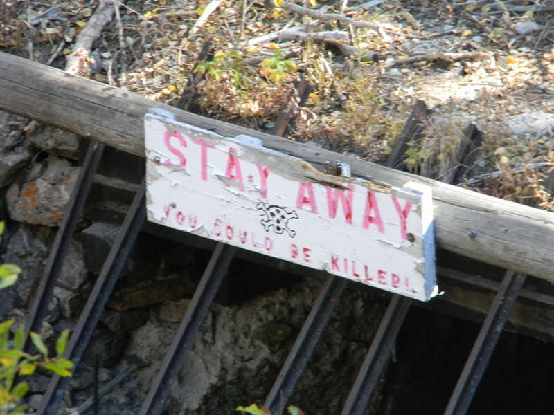
Laramie and Poudre Tunnel inlet October 3, 2010.
The Laramie, the river at the center of the court’s ruling, has its headwaters in the Northern Front Range Mountains about 40 miles west of Ft. Collins. From there it flows 280 miles north into Wyoming, reaching the North Platte River near Ft. Laramie, WY. Wyoming farmers and ranchers began using the river for irrigation purpose in the 1880s and 1890s. Within Colorado there is little irrigable land along the river’s path, but its elevation just happens to be about 225 feet higher than the Cache La Poudre River where the two rivers are a little more than two miles apart. Thus, in 1909 two Colorado water companies, including the North Poudre Irrigation District, a client of Colorado’s Delph Carpenter, began construction of an 11,500 foot tunnel that would divert 800 cfs (essentially the entire river in low flow years) from the Laramie River into the already fully developed Poudre. In 1911 the State of Wyoming filed suit against Colorado to protect its existing irrigators.
Over the course of the eleven-year case, the Supreme Court held three oral hearings, the last in January 1921, only weeks before the Colorado River Commission first met. Wyoming’s basic argument was that Colorado’s proposed project would cause great damage and injury to its citizens who were already using the river for irrigation. Colorado’s basic argument was that it had a sovereign right to take and use any water within its boundaries without regard to the rights of states or individuals outside of Colorado. Both states used prior appropriation, but details of how the doctrine was administered were quite different. In Colorado water rights were adjudicated by the local district court. In Wyoming they were granted by a state Board of Control.
The opinion, written by Justice William Van Devanter, determined that since both states used prior appropriation, this doctrine would set the rule for the equitable interstate division of water on the Laramie River. The effect of the opinion was that to protect downstream senior appropriators in Wyoming, the Colorado project would be limited to an annual diversion of 15,500 acre-feet per year, about 20% of the original plan. The opinion was not a complete loss for Colorado. Wyoming had challenged the legality of the Colorado’s project because it was a transbasin diversion. The court found that there was nothing illegal with projects that move water.
As soon as the opinion was released, Colorado River Compact Commission Secretary Clarence Stetson sent copies of the opinion to the commissioners along with a six-point summary. For Colorado’s Carpenter, the loss was probably not a great surprise, but it was nonetheless a bitter defeat. He told his upper river colleagues that the decision left them badly exposed.
For the compact negotiations, the court decision required Carpenter to change his basic strategy. Up to this point, he and Utah’s Caldwell had held firm for a compact based on the concept that water projects in the Lower Basin would never interfere with water uses in the Upper Basin. The decision coupled with building public pressure for Congressional approval of a large storage reservoir to control floods, regulate the river, and produce much needed hydroelectric power meant that it was now time for Carpenter to propose a more practical alternative. He turned his attention to a concept proposed by Reclamation Service Director Arthur Powell Davis at the Los Angeles field hearing – a compact based on dividing the use of the river’s waters between two basins.
Stetson’s goal was to get the Commission back together in August. Hoover had asked New Mexico Governor Merritt Mechem for a recommendation on where they might meet in relative seclusion. Mechem found such a place, but finding a date that would work for Hoover and the other commissioners would push the meeting date out to November – stay tune[d].
Map of the North Platte River drainage basin, a tributary of the Platte River, in the central US. Made using USGS National Map and NASA SRTM data. By Shannon1 – Own work, CC BY-SA 4.0, https://commons.wikimedia.org/w/index.php?curid=79266632
In the 1930s, an archeologist from the Smithsonian wrote a short paper remarking on the exquisite vegetation around First Nation villages in Alaska. The villages’ surroundings were filled with nuts, stone fruit, berries, and herbs—several non-native to the area and many that would never grow together naturally. The significance of these forest gardens went largely overlooked and unrecognized by modern archeology for the next 50-plus years.
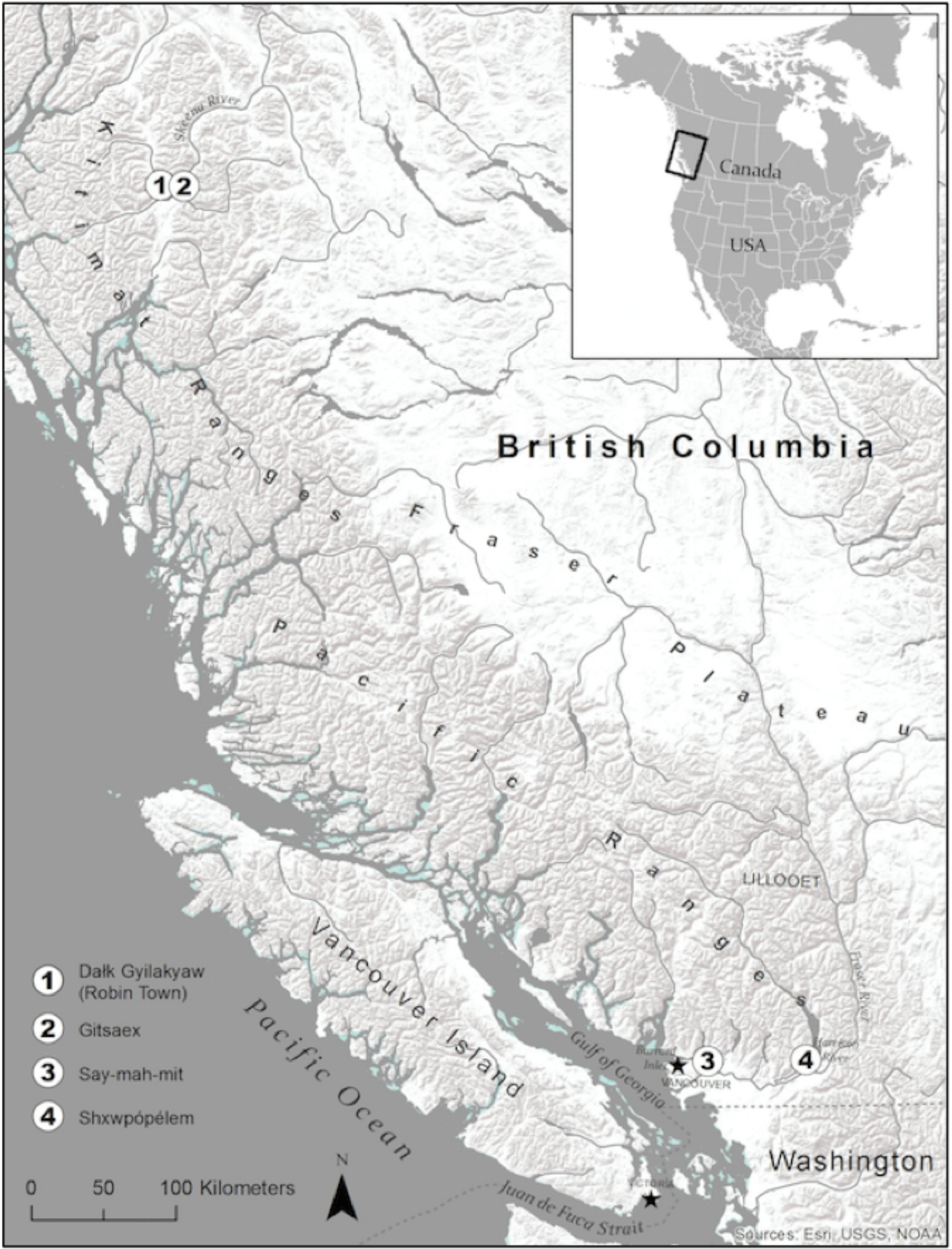
Location of Study Sites. Archaeological village complexes in this study: (1) Dałk Gyilakyaw on the Kitsumkalum River, a tributary of the Skeena River; (2) Kitselas Canyon (Gitsaex) on the Skeena River; (3) Say-mah- mit in Burrard Inlet; (4) Shxwpópélem on the Harrison River. Map credit: Ecology and Society
In the last few decades, archeologists have learned that perennial forest management—the creation and care of long-lived food-bearing shrubs and plants next to forests—was common among the Indigenous societies of North America’s northwestern coast. The forest gardens played a central role in the diet and stability of these cultures in the past, and now a new publication shows that they offer an example of a far more sustainable and biodiverse alternative to conventional agriculture.
This research, which was done in collaboration with the Tsm’syen and Coast Salish First Nations, shows that the gardens have become lasting hotspots of biodiversity, even 150 years after colonists forcibly removed the inhabitants from their villages. This work, combining archeology, botany, and ecology, is the first to systematically study the long-term ecological effects of Indigenous peoples’ land use in the region. The gardens offer ideas for farming practices that might restore, rather than deplete, local resources to create healthier, more resilient ecosystems.
Cultivated over millennia
Indigenous forest gardens in the tropics and subtropics have been increasingly appreciated as presenting a valuable model for more sustainable agriculture. The practices have been somewhat easier for researchers to identify because some are still in use today, and they also more closely resemble Eurocentric notions of agriculture—such as annual cycles of planting and harvesting.
In contrast, the forest gardens of the Pacific Northwest are cleared spots nestled alongside the native coniferous forests. The gardens contain collections of perennial plants and shrubs like Pacific crabapple, wild cherry, plum, soapberry, wild ginger, rice roots, and medicinal herbs. Rather than engaging in annual planting cycles, the Indigenous people collected, transplanted, and carefully tended these plants over many years—pruning, fertilizing, coppicing, and using controlled burns to promote productivity.
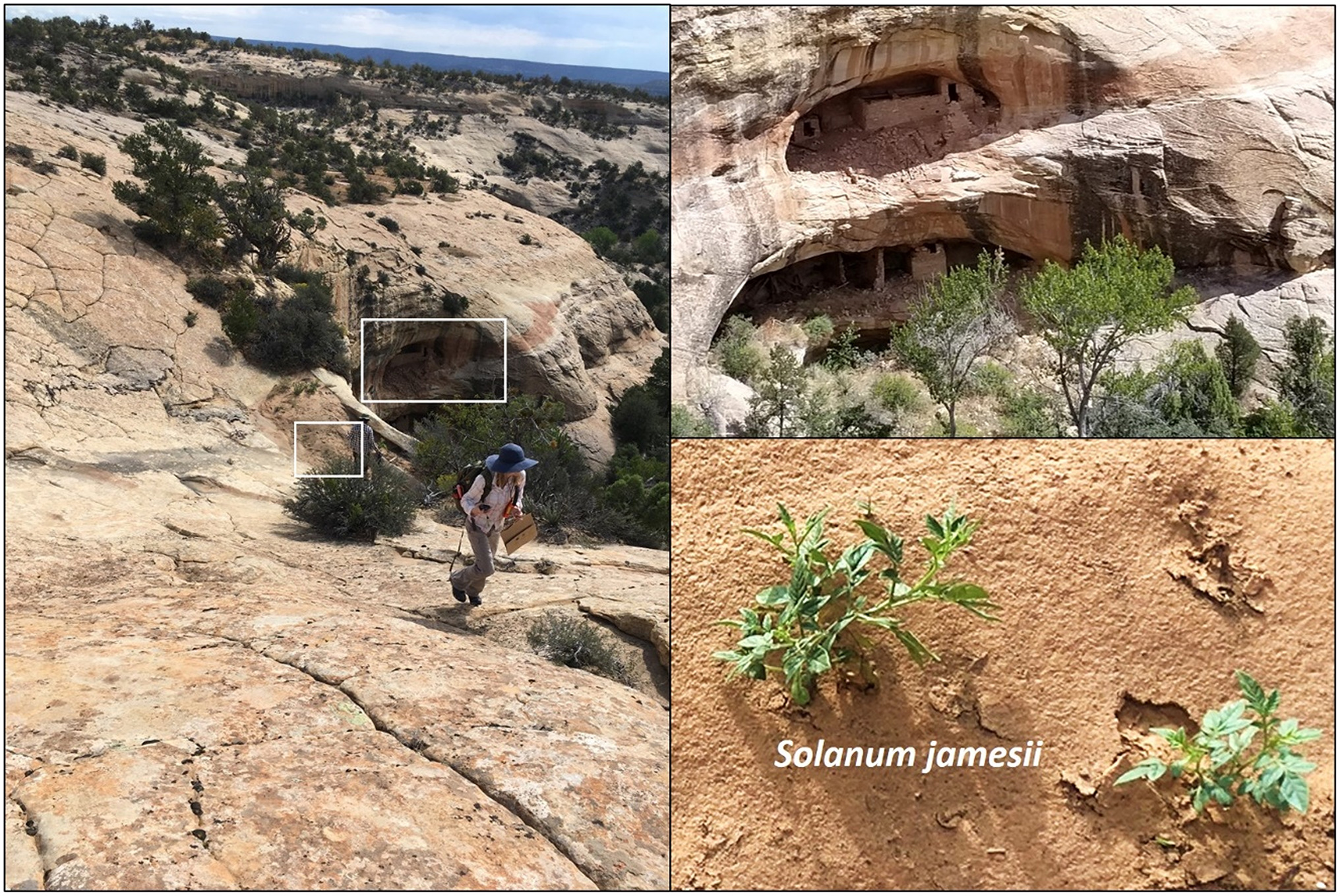
Four Corners potato (Solanum jamesii) growing in sand at the base of slick rock waterfall, just above site 42SA244, a two-story cliff dwelling in Bears Ears. The species reproduces only by tubers that have very limited dispersal capability. The situation repeats itself among archaeological sites in southern Utah, Arizona, and New Mexico. Photos by Kari Gillen via the paper “Plant species richness at archaeological sites suggests ecological legacy of Indigenous subsistence on the Colorado Plateau
These lasting effects are seen elsewhere in North America, including the semiarid Bears Ears region in Utah. The archeological sites in both regions have diverse plant species that cannot be explained by natural causes alone, suggesting the potential transplantation of these species over significant distances.
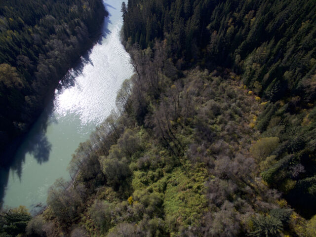
From above, the cultivated area is move obvious. Photo credit: Ars Technica
One of the cornerstone species of the Pacific Northwest gardens—hazelnut—was even transplanted from 700 km away. “Hazelnut is a big piece of our understanding of forest gardens because it was one of the first species recognized as having no business being there—but it’s in this nice pocket where we see a cultural explosion about 5000 years ago,” said Chelsey Armstrong, first author of the study. “As I studied, it was increasingly clear that it wasn’t just hazelnut—these were entire ecosystems. And it wasn’t just gathering—this was a completely different food system where there was clearly active management and investment in the landscape.”
Sustainable and biodiverse
For their latest research, Armstrong and her collaborators selected villages that had been continuously inhabited for more than 2,000 years before the residents were forced to leave. The team surveyed the plant species and an ecological metric called “functional diversity.” The researchers measured the range of traits represented, such as seed mass, shade tolerance, and the method of pollination and seed distribution.
By comparing the gardens to the neighboring forests, the researchers’ results clearly showed that the gardens had a much higher species and functional diversity. In addition, the gardens frequently showed a carefully overlapped structure, with a canopy of fruit and nut trees, a mid-layer of berries, and roots and herbs in the undergrowth. Thanks to the increased availability of fruit, nuts, and other edible plants, these places also supported local wildlife, such as moose, bears, and deer.
“There’s a kind of false dichotomy debate going on right now that biodiversity is at odds with food production, and what we see here is very clearly that it’s not,” said Armstrong. “Forest gardens are one of the examples of how you can get multiple species occupying multiple niche spaces—there are all sorts of ecological lessons there.”
Restoring a legacy
Although the First Nation people aren’t using the gardens as much as when the villages were inhabited, many have been returning to them over the past decades to preserve these places and the knowledge about them. Despite being confined to reservations and penalized for practicing their culture in the past, there’s been a strong movement to restore as much of the traditional knowledge as possible.
“There’s a conscious effort to revive traditional use of the land—it’s taught now in our schools, and it’s being shared more openly among all age groups,” said Willie Charlie, a former chief and current employee of the Sts’ailes Nation of the Coast Salish people who has helped form a working group to maintain and manage access to the gardens. “More and more people are going back to these traditional places to harvest the plants, herbs, medicine, and food.”
Dozens of tribes live in the region, each with different practices and different relationships to their ancestral lands, but land-based foods are a staple for many. Armstrong is collaborating with these communities and designing her research to aid the preservation and restoration of the gardens—and to provide additional evidence to counter local logging interests as well.
“Our people’s belief is that we don’t own the land—we are the land,” said Charlie. “Sharing our continued use of the land is a way of bringing awareness, which brings protection.”
K.E.D. Coan is a freelance journalist covering climate and environment stories at Ars Technica. She has a Ph.D. in Chemistry and Chemical Biology.