Please join us at South Park’s Buffalo Peaks Ranch as author Ben Goldfarb discusses the world of beavers and the landscapes they create. Ben is the author of of Eager: The Surprising, Secret Life of Beavers and Why They Matter, the winner of the 2019 PEN/E.O. Wilson Literary Science Writing Award and named one of the best books of 2018 by the Washington Post. This special event is FREE for all who register!
Buffalo Peaks Ranch will stay open after Ben’s talk,until 3pm. We’ll be offering a Ranch Tour, and the opportunity for you roam the ranch and river, with time to sketch, take photos, and add to the ranch’s Bird List. Bring a picnic lunch if you like. You’ll also be able to explore the ranch’s new beaver pond — but be sure to bring your boots for that!
American beaver, he was happily sitting back and munching on something. and munching, and munching. By Steve from washington, dc, usa – American Beaver, CC BY-SA 2.0, https://commons.wikimedia.org/w/index.php?curid=3963858
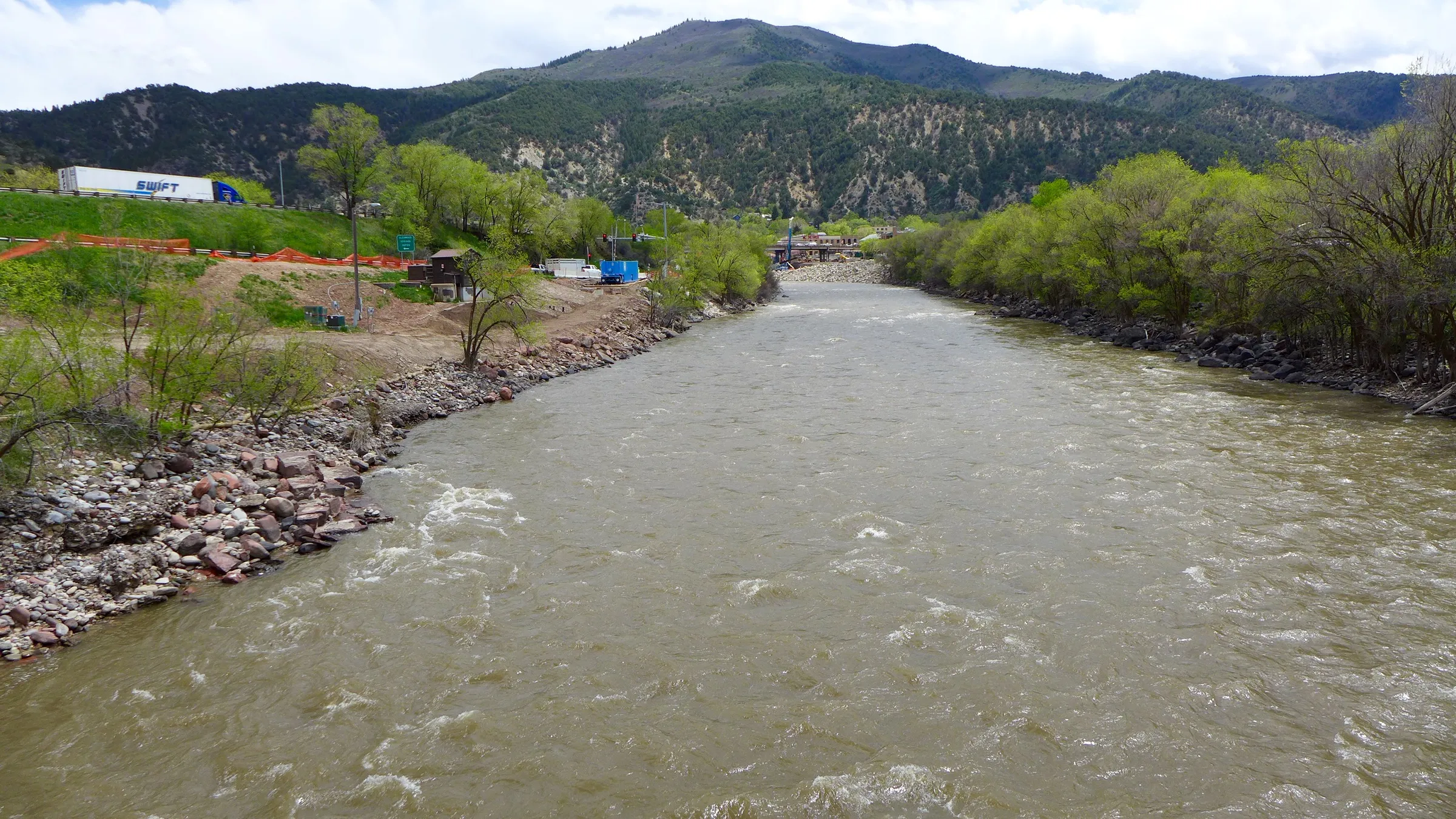
A view looking up the Colorado River from the pedestrian bridge over the river, just upstream of the river’s confluence with the Roaring Fork River. The location is one of three sites where the City of Glenwood Springs plans to build a whitewater park using a water right for recreation. CREDIT: BRENT GARDNER-SMITH/ASPEN JOURNALISM
The tax-funded West Slope entity has launched a special round of “Accelerator Grant” opportunities aimed at providing support for grant-writing, feasibility evaluation, design, preliminary environmental review, benefits analysis, and engineering to support applications for federal funding made available by the law. The district will consider paying for up to 85% of the funding needed by an applicant to pursue the federal funds. It also is planning a free online webinar June 29 to help Western Slope water users navigate the funding opportunities provided by the law and discuss the Accelerator Grant program. District staff will discuss federal funding categories for water projects, how to put together a successful federal grant application, and how to leverage other grant opportunities to maximize funding and project impacts…
The financial aid the river district is offering to help entities apply for federal funding is made possible by a tax measure that voters in its 15 counties approved in 2020. Some of the tax revenues go toward the district’s operations, but most of it, more than $4 million a year, goes to support entities on a range of water-related projects.
The deadline to apply for Accelerator Grants is Aug. 1. More information may be found by visiting https://www.coloradoriverdistrict.org/ and clicking on the Community Funding Partnership link.
Western Resource Advocates signed on to a revised settlement agreement filed today in Xcel Energy’s Electric Resource and Clean Energy Plan proceeding before the Colorado Public Utilities Commission. The new settlement includes accelerated dates for retiring the Comanche 3 coal unit, helps avoid building unnecessary and potentially stranded new fossil gas generation, and establishes commitments to achieve interim carbon emission reductions in 2024 and 2027.
“If approved, this settlement secures the next stage of Colorado’s energy transition, ensuring commitments from Xcel to reduce its harmful fossil-fuel emissions that contribute to climate change,” said Gwen Farnsworth, Western Resource Advocates’ managing senior policy advisor in Colorado. “The earlier date for retiring Comanche 3, plus cutting the assumed lifetime for any new fossil gas generation and establishing interim targets for reducing carbon emissions, will all help Colorado reach its climate goals. Important provisions also extend community assistance to the Pueblo community for 10 years and will help in the transition to new economic opportunities as the coal-fired Comanche unit closes.”
These are all key improvements to the settlement WRA has advocated for during the commission proceeding on Xcel’s plan. WRA opposed a previous version of the settlement signed by other parties late last year. Specifically, the new settlement calls for Xcel to:
Retire Comanche 3 by January 1, 2031 — four years earlier than the original settlement, which will avoid an additional 3.5 million tons of carbon emissions compared to the original settlement filed in November and will cut toxic local air pollutants in Pueblo;
Commit to interim reductions in carbon dioxide emissions, with targets of a 50% reduction by 2024 and 65% by 2027, compared with the utility’s 2005 levels;
Cut the modeled lifetime for any new fossil gas generation to 25 years; and
Expand Xcel’s Just Transition Plan, by extending the community assistance benefits for Pueblo to 10 years.
The settlement overall will provide more than 17 million tons of carbon dioxide emissions reductions. Reducing these fossil-fuel emissions will help curb the harmful effects of climate change. The Comanche generating station is also responsible for over 80% of all toxic chemicals released into the surrounding community of Pueblo.
Several provisions in the revised settlement reduce the utility’s expected future reliance on fossil-fuel gas generation. According to the Intergovernmental Panel on Climate Change, reducing methane emissions from fossil-fuel gas is one of the biggest and fastest strategies for slowing climate change.
The Xcel settlement today follows the utility’s February 2021 announcement of its Clean Energy Plan committing to achieve an 85% reduction in carbon emissions and 80% renewable energy generation by 2030, as well as 100% clean energy by 2050. A 2019 Colorado law requires Xcel to reduce its emissions by 80% below 2005 levels by 2030. In 2019, the Colorado Legislature also passed House Bill 1261, requiring the state to reduce its economy-wide greenhouse gas emissions by 50% below 2005 levels by 2030 and 90% by 2050.
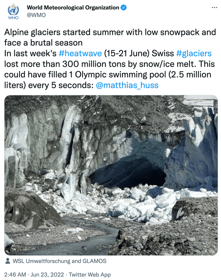
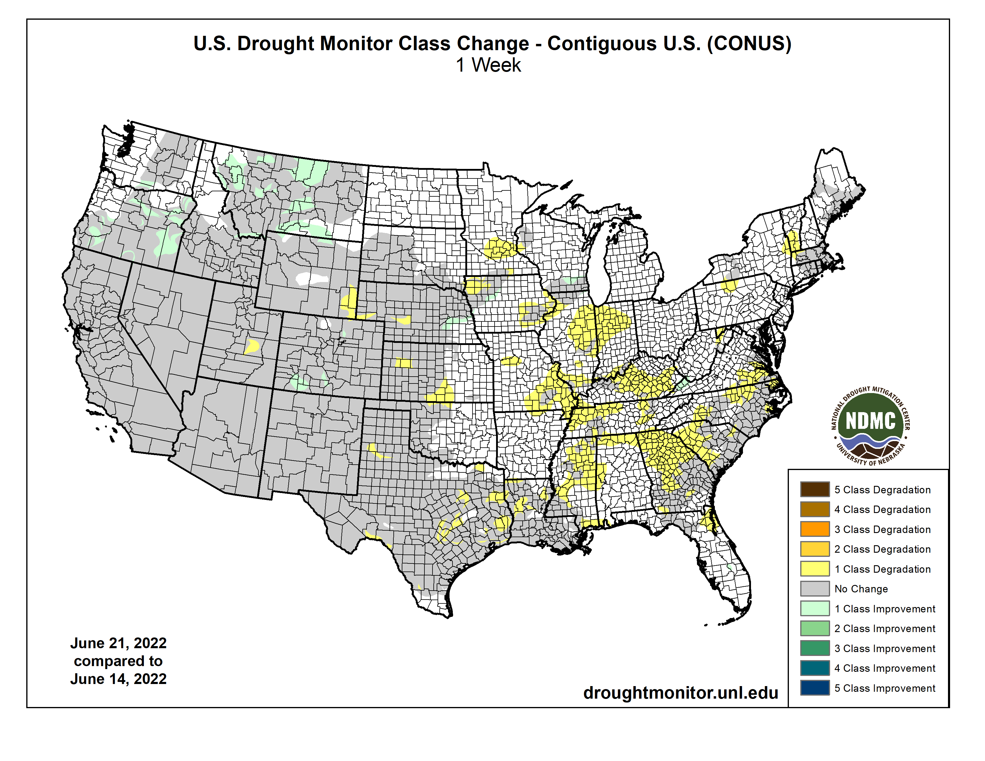
Much above-normal temperatures plagued much of the central and eastern contiguous U.S. (CONUS) this week from the Great Plains eastward to the Mississippi Valley and Southeast. The western third of CONUS, the Northeast, and coastal Mid-Atlantic experienced seasonal to below-normal temperatures. Precipitation was lacking in many locations that experienced excessive (in some cases record) heat, leading to widespread expansion of abnormal dryness and moderate drought conditions along the Mississippi and Ohio Valleys, the Southern Plains, and the Southeast. From the Central Plains northward, despite the excessive heat (daytime high temperatures above 100°F several days this week), recent improvements driven by an active storm track leading up to this week resulted in modest, more targeted degradations in the drought depiction. Another week of heavy rainfall warranted improvements in Montana. In the Pacific Northwest, below-normal temperatures and recent improvements from an active weather pattern leading up to this week resulted in improvements in some of the long-term drought indicators. Heavy rainfall associated with the Southwest Monsoon also fell across parts of the Four Corners region. However, this only acted to halt any further degradations this week. Given drought is strongly entrenched in the Four Corners, an active Southwest Monsoon circulation will need to persist for conditions to improve…
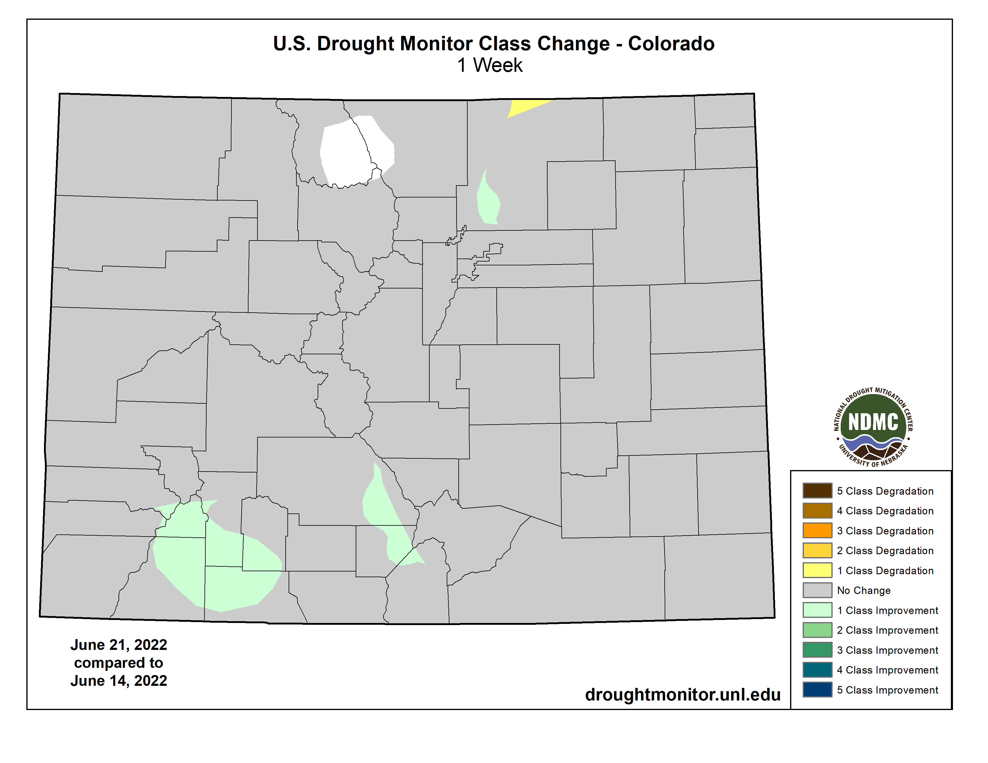
Much of the High Plains Region has seen beneficial rainfall and temperatures averaging near to below-normal over the past 30 days, with the exception of a few locations. Some targeted improvements were warranted across parts of southeastern Nebraska this week, which picked up 1.5 to 3 inches of rainfall (per AHPS estimates). Targeted improvements were also made in parts of Colorado and northern Wyoming due to a robust Southwest Monsoon circulation and an active storm track across the Northern Tier, respectively. Conversely, high winds and hot temperatures, which exceeded 100°F several days this week, resulted in high evapotranspiration rates and, subsequently, degradations for parts of the Central Plains. Evapotranspiration rates approaching 0.5 inches per day were reported in western Nebraska…
Colorado Drought Monitor one week change map ending June 21, 2022.
Much of the Northern Tier of the U.S. from the Pacific Northwest to the Northern Plains has seen marked improvements in recents months due to a persistent storm track and near to below-normal temperatures. That same pattern continued this week, leading to 1-category improvements from the Pacific Northwest eastward to Montana. Improvements in Montana are the result of 7-day precipitation surpluses of more than 1 inch for many locations and near to below-normal temperatures. In the Pacific Northwest, long-term indicators continued to improve due to the recent storminess and below-normal temperatures leading up to this week. In the Four Corners region, heavy rainfall was observed in a large swath stretching across western New Mexico, due to a robust Southwest Monsoon circulation. However, there were no marked improvements to drought indicators this week to warrant improvements. Given drought is strongly entrenched in the Four Corners, an active Southwest Monsoon circulation will need to persist for conditions to improve…
Extreme heat, high winds, and below-normal precipitation continued in Texas, leading to another round of degradations this week across the state. Extreme heat and below-normal precipitation also lead to the widespread expansion and addition of abnormal dryness (D0) and moderate drought (D1) across the Lower Mississippi and Tennessee Valleys. Soil moisture conditions quickly deteriorated this week (falling below the 30th percentile across many areas that saw expansion). Additionally, daily and 7-day average USGS stream flows fell below-normal (below the 24th percentile) and vegetation indices are also indicating increased stress to plants. Short-term (30 to 60-day) deficits are starting to accumulate also, with many areas across the Lower Mississippi and Tennessee Valleys experiencing 4 to 6 inch rainfall deficits over the last 60 days…
Looking Ahead
A storm system near the coast of the Carolinas will bring chances for heavy rainfall to parts of the Eastern Seaboard over the next couple of days (June 23-24). Meanwhile, another storm system will intensify and move eastward from the Northern Plains to the Great Lakes. The trailing frontal boundary associated with this system will bring increased chances of rainfall to much of the eastern U.S. However, rainfall is likely to be hit-or-miss and remain below-normal for many locations, especially along the Lower and Middle Mississippi Valley. The passage of the frontal boundary in the eastern U.S. should bring more seasonal daytime temperatures by the start of the work week (Monday, June 27). An active Southwest Monsoon circulation is forecast to bring increased precipitation and below-normal maximum temperatures to parts of the Four Corners region, with below-normal maximum temperatures extending into the Central Plains.
The Climate Prediction Center’s 6-10 day outlook (valid June 28 to July 2, 2022) favors above-normal temperatures across much of California, the Great Basin, and Eastern Rockies. Above-normal temperature probabilities also extend from the Central and Southern Plains eastward to the Appalachians and southward to the Gulf Coast. Near to below-normal temperatures are favored across the Northern Tier of the contiguous U.S. (CONUS), as mean mid-level high pressure is expected to remain farther to the south. Below-normal temperatures and above-normal precipitation are favored for much of the Four Corners region, associated with a robust Southwest Monsoon circulation. Near to above-normal precipitation probabilities also extend along the Northern Tier from the Pacific Northwest to the Great Lakes, associated with storm activity. Increased chances of below-normal precipitation across the northern Great Basin and from the Middle Mississippi Valley to the Northeast are associated with dry northerly mean surface flow and surface high pressure, respectively.
Drought Monitor one week change map ending June 21, 2022.
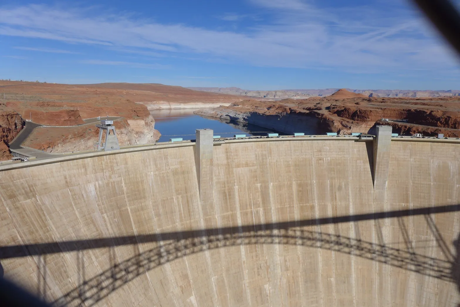
Glen Canyon Dam in Page, Ariz., forms Lake Powell. It’s still unclear how Colorado would participate in a federally mandated plan to conserve 2 to 4 million acre-feet water to protect the Colorado River system. CREDIT: HEATHER SACKETT/ASPEN JOURNALISM
Glen Canyon Dam is operating at 60 percent of its hydroelectric capacity.
Hydropower generation will likely shut down when Lake Powell’s elevation drops below 3,490 feet. Currently the lake is at 3,534 feet.
Besides the kilowatt-hours it generates, Glen Canyon provides key services to the electric grid.
Critics of the Bureau of Reclamation had a favored slur for the concrete and earthen walls that the federal agency raised across magnificent canyons of the Colorado River watershed: cash register dams.
The dig wasn’t wrong, especially during the agency’s mid-20th century construction spree. For decades, hydroelectric dams in the Colorado River Storage Project supplied cheap power and a relatively steady revenue stream from electricity sales that helped repay dam construction and operation costs while also subsidizing crop production and settlement of the American West.
Today, the cash registers are ringing at much lower decibels. Sapped by a warming climate, the grand reservoirs of the Colorado River are in a two-decade decline, dropping low enough that hydropower from one of the grandest, Lake Powell, may soon be in doubt.
The country’s second largest reservoir and a lynchpin in the intermountain electric grid, Powell is more dirt than water these days. The reservoir holds just 27 percent of its full capacity. In April it dropped to a level not witnessed since Glen Canyon Dam was completed nearly six decades ago. Water in Powell is released through turbines in the dam, generating power that electrifies homes, businesses, rural coops, and irrigation pumps across six states and more than 50 Native American tribes.
Lake Powell’s feeble condition is part of a climate reckoning in the West that links water, ecosystems, food production, and energy generation. A drying climate and withering heat in recent years have pummeled the region: water cuts to farmers, dry wells, mass fish and bird die-offs, and depleted reservoirs that have decimated hydropower output.
Glen Canyon Dam is now operating at about 60 percent of its designed hydroelectric capacity, according to Nick Williams, the Upper Colorado River Basin power office manager for the Bureau of Reclamation. Rated for 1,320 megawatts — roughly the size of a large fossil fuel plant — the dam is now capable of only 800 megawatts.
The failure of Glen Canyon Dam to produce hydropower, in isolation, would be bothersome for energy markets but not a catastrophe. It would raise the cost of electricity for 5 million retail power customers, increase greenhouse gas emissions associated with electricity generation, and eliminate key grid-support services that hydropower provides.
But a loss of generating capacity at Glen Canyon at the wrong time — in the summer, for instance, when electricity demands are high — combined with other power station outages could contribute to an electric supply contagion, grid strain, and blackouts in the western states, according to a recent reliability assessment from a national energy watchdog.
Recognizing this, the Department of the Interior took emergency action last month to throw a life preserver at Lake Powell. The Bureau of Reclamation’s parent agency ordered it to hold back more water in the reservoir and at the same time release reinforcement supplies from Flaming Gorge, a smaller reservoir higher in the watershed. Together the actions will add nearly 1 million acre-feet to Powell this year, equivalent to 16 feet of water in the beleaguered reservoir.
Explaining the decision, Tanya Trujillo, the Interior Department’s assistant secretary for water and science, said that the integrity not only of the dam’s power generation but also its water delivery system was at stake if Powell were to breach elevation 3,490 feet — the level at which hydropower generation at Glen Canyon Dam would likely cease.
“In such circumstances,” Trujillo wrote to water leaders in the basin states, “Glen Canyon Dam facilities face unprecedented operational reliability challenges, water users in the Basin face increased uncertainty, downstream resources could be impacted, the western electrical grid would experience uncertain risk and instability, and water and power supplies to the West and Southwestern United States would be subject to increased operational uncertainty.”
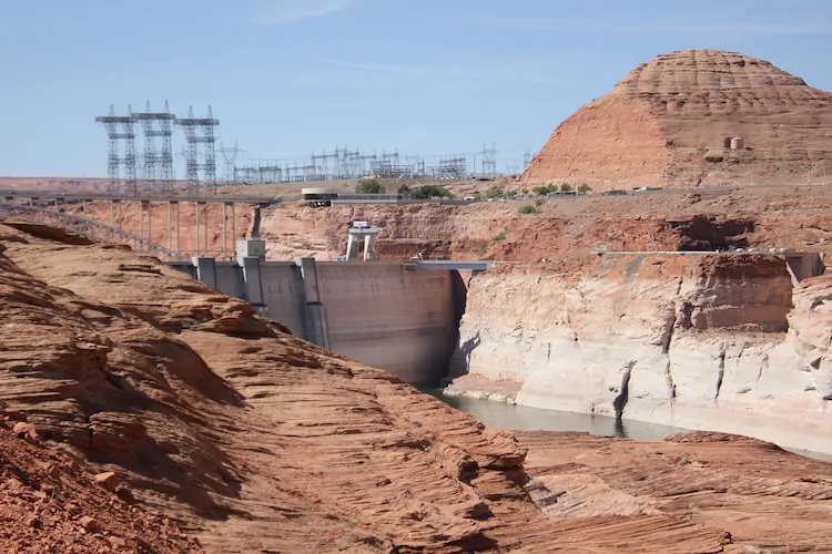
Glen Canyon Dam from the east side. Photo credit: Allen Best/Big Pivots
Uncertain, Unstable Times
A dress rehearsal already occurred last summer when Lake Oroville, California’s second largest reservoir, dropped below its minimum power level, and Hyatt Powerplant stopped producing electricity due to low water for the first time in its history. The same fate could await Lake Powell.
Bureau of Reclamation projections indicate the reservoir has a 10 percent chance in the next two years of breaching 3,490 feet. As of June 5, the reservoir’s elevation was 3,534 feet and slowly climbing as melting snow and Interior’s emergency actions contribute to a seasonal rise that has added nearly 12 feet to the reservoir since it bottomed out in April. It is out of the danger zone, for now.
Water users in the Colorado River basin are already feeling the effects of depleted reservoirs. Lake Mead, the nation’s largest reservoir and located on the Colorado River a few hundred miles downstream, also plunged to a record low this spring. A subsequent shortage declaration means that Arizona and Nevada must reduce their withdrawals.
Water reaches Mead by flowing through Glen Canyon. The Interior Department moved this spring to prop up Powell because it worried about Glen Canyon’s water delivery system in low-water conditions. Water is released downstream through the penstocks, which feed the dam’s turbines. If the lake drops too low to produce power, that route is cut off. Water would instead be released through the outlet works, which are untested in extended use as the primary water delivery option.
Glen Canyon’s power customers are also in a pinch.
When Powell drops closer to the 3,490-foot level, operating the dam becomes a game of inches, Williams said. The top of the penstocks — the 15-foot diameter pipes that send water to the turbines — are at elevation 3,477.5 feet. But as the reservoir approaches that level, vortexes could form as water is drawn into the pipes. The violent whorls can injure the dam’s power-generating equipment.
For now, 3,490 feet is the red line because that was the designer’s safe estimate and Glen Canyon was able to generate at that level when Powell was being filled in the 1960s. Even so, Williams, the power office manager, said that Reclamation staff is modeling operational changes to eke out a few more feet of operating range.
The power that Glen Canyon generates is pooled with other federal dams in the upper basin and sold by the Western Area Power Administration. Until last December, WAPA was purchasing power for its customers to compensate for the hydropower shortfall. That model led to a financial cliff.
Due to the expense of market-rate replacement power, WAPA was at risk of depleting the upper basin fund. The fund functions as a checking account, taking in power revenues and paying out costs. Those costs include dam construction repayment and annual dam operations and maintenance. They also include successful environmental programs intended to protect endangered fish in the Colorado and San Juan rivers, reduce salt loads in the river, and make Glen Canyon water releases less damaging to the river corridor.
In 2021, the fund was in jeopardy due to declining hydropower generation. The fund balance was cut in half, dropping from $146 million in January 2021 to $74 million by the end of the year. That resulted in an emergency rate change in December that is expected to stabilize the fund, said Lisa Meiman, a WAPA spokesperson. In most cases, WAPA will no longer buy market-rate power. Individual utilities will shoulder all the added expense. One other action alleviated financial pressure on the basin fund: direct appropriations from Congress to the environmental programs.
Less hydropower will force utilities to look elsewhere for replacement supplies, including from fossil fuel sources. The effect of a hydropower shortfall varies with region, weather, and time of day or year. More coal and natural gas will certainly increase greenhouse gas emissions from the power sector.
But how much? Kelly Sanders of the University of Southern California says the magnitude of a carbon emissions increase due to drought is difficult to calculate, owing to the complexity of electricity supply and demand. The answer is usually only apparent much later, after rigorous data analysis. However, losing a carbon-free source like hydropower means that, all else being equal, the average carbon emissions for electricity goes up.
Customers of Glen Canyon power are confronting those tradeoffs as they search for replacement power.
As a share of its electricity supply, the Navajo Tribal Utility Authority is one of the biggest consumers of Upper Colorado hydropower. In 2020, NTUA acquired 42 percent of its electricity from the Upper Colorado dams.
If power generation forecasts hold true, NTUA estimates that the utility would pay $4.5 million more for electricity this year, according to Srinivasa Venigalla, the deputy general manager. Those costs would be passed on to the utility’s roughly 43,000 residential and commercial customers, he said.
Venigalla hopes Glen Canyon does not go dark. But his utility is preparing in case that day comes. NTUA already has 55 megawatts of solar generation capacity on Navajo lands and another 4 megawatts will come online by the end of this year.
The solar installations won’t completely replace Glen Canyon’s hydropower, Venigalla said. But they will reduce the utility’s purchases of market power.
A diversity of power sources will help other utilities that receive Glen Canyon hydropower. Tri-State Generation and Transmission, a cooperative with 42 utility members in Colorado, Nebraska, New Mexico, and Wyoming, usually acquires 8 percent of its power from the Upper Colorado hydroelectric system.
Lee Baughey, vice president for communications, said that the utility expects its hydropower allocation to drop by a third this year.
“It places pressure on our costs, but we can manage through,” Baughey said.
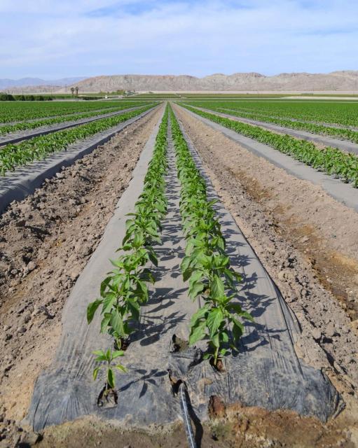
Households have company in that regard. Roosevelt Irrigation District pumps water to about 38,000 acres in Maricopa County, Arizona. Donovan Neese, the district superintendent since 2011, said retail power customers span the breadth of the county’s agribusiness: cold storage facilities for fruits and vegetables, dairies, cotton gins, and feed mills.
About half the district’s power comes from Glen Canyon and Hoover dams. Neese is in the process of developing the budget for the next fiscal year and did not have exact numbers, but the effect for Roosevelt customers is the same as elsewhere: less hydropower means higher costs.
“That means we continue to advocate for water conservation,” Neese said.
Farm fields in Arizona, where irrigation pumps are partly powered by Glen Canyon Dam. (Source: Water Education Foundation)
Hydropower as a Service
Glen Canyon’s value extends far beyond the customers. The dam is more than just the kilowatt-hours it generates, said Nathalie Voisin of Pacific Northwest National Laboratory. It also plays an important role in the operation of regional electric grids.
In the southwestern states encircling the Colorado River basin, the majority of power generation is not derived from the force of flowing water. Most comes from fossil fuels, wind, and solar. Nonetheless, hydropower fulfills a valuable niche. Because its generators can deliver electricity quickly — “ramping” in the lingo — hydro bridges the period when solar and wind power wane and before gas-fired turbines can power up. This quick-start capability is especially important when electricity demand is high, such as summer heat waves.
“The economic and reliability values from ramping are very large,” said Voisin, who studies hydropower and its response to changes in climate, season, and technology. “There’s a lot at stake for not being able to get Glen Canyon working for hydropower operation during the summer time.”
Lake Powell, in effect, functions as a large battery, able to be turned on and off to meet fluctuating power demands. Even if Powell were to be drained and the water stored in Lake Mead, as some environmental groups advocate, the grid benefits of Glen Canyon would still need to be reckoned with.
“Glen Canyon cannot be easily replaced with other renewables because Glen Canyon is already critical in their integration into the grid,” Voisin explained. “The replacement technology needs to compensate for the range of grid services provided by Glen Canyon, which is more than capacity and generation. Storage in particular would be needed.”
A rapid increase in water storage behind Glen Canyon is unlikely. Analysts at the Bureau of Reclamation simulate future Colorado River conditions every month. The latest model scenarios show a 10 percent chance that Lake Powell drops below 3,490 feet by April 2024. That’s less than two years away. Not enough days to completely reconfigure the region’s energy services. But plenty of time to ponder a future without Glen Canyon hydropower.
The Division of Water Resources, Division 1 Office in Greeley, CO is hiring for the Deputy Water Commissioner for Water Districts 6 & 7 – Engineering/Physical Sciences Tech I position. The purpose of this position is to ascertain the available surface water supply and distribute, control and regulate the surface and groundwater tributary to the South Platte River in the Boulder Creek and Clear Creek basins on a daily basis pursuant to water decrees, substitute water supply plans and state statutes, and may assist in adjacent water districts with water administration. Anyone interested in learning more about the position or seeking to apply can access the following link to the job announcement on the State of Colorado Job Opportunities website: