The latest #ENSO diagnostic discussion is hot off the presses from the #Climate Prediction Center

Plume of ENSO models May 2022 via the Climate Prediction Center.

Click the link to read the article on the Climate Prediction Center website:

EL NIÑO/SOUTHERN OSCILLATION (ENSO) DIAGNOSTIC
DISCUSSION

issued by

CLIMATE PREDICTION CENTER/NCEP/NWS
and the International Research Institute for Climate and Society

9 June 2022

ENSO Alert System Status: La Niña Advisory

Synopsis: Though La Niña is favored to continue through the end of the year, the odds for La Niña decrease into the Northern Hemisphere late summer (52% chance in July-September 2022) before slightly increasing through the Northern Hemisphere fall and early winter 2022 (58-59% chance).

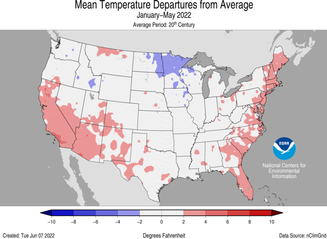
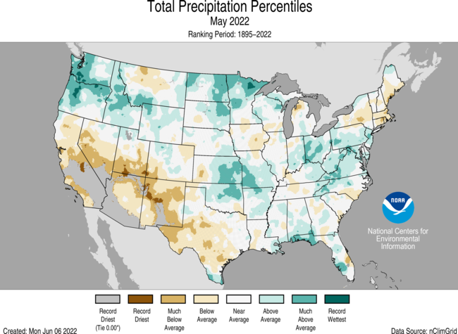
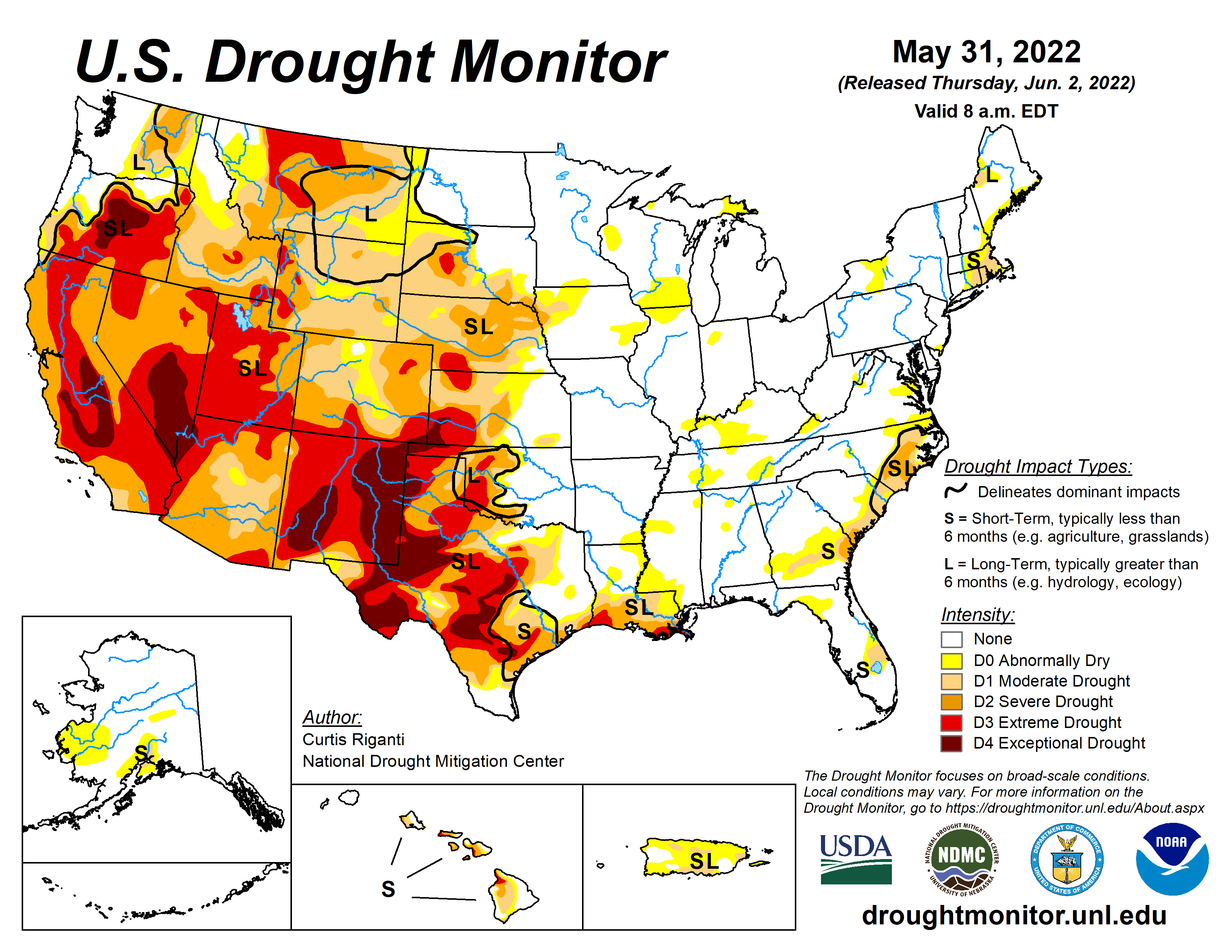
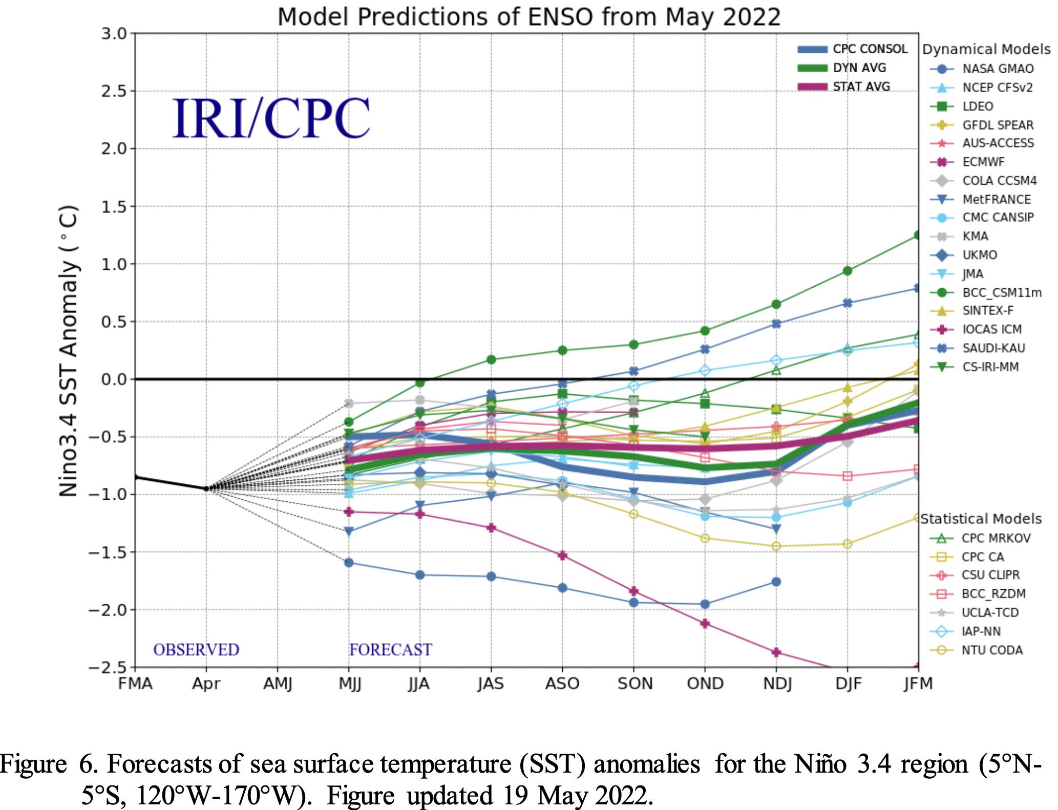
During May, below-average sea surface temperatures (SSTs) continued across most of the central and eastern equatorial Pacific Ocean. However, negative SST anomalies weakened during the past month, as reflected by the Niño indices, which ranged from -0.6ºC to -0.9ºC during the past week. Subsurface temperatures anomalies (averaged between 180°-100°W and 0-300m depth) also weakened with values returning to near zero. Below-average subsurface temperatures persisted near the surface to at least ~75m depth from the central to the eastern equatorial Pacific Ocean, with above-average temperatures continuing at depth (~100 to 200m) in the western and central Pacific Ocean. Low-level easterly wind anomalies prevailed in the east-central equatorial Pacific, while upper level westerly wind anomalies continued over most of the equatorial Pacific. Convection was suppressed over the western and central Pacific and was weakly enhanced over parts of Indonesia. Overall, the coupled ocean-atmosphere system continues to reflect La Niña.

The most recent IRI/CPC plume average for the Niño-3.4 SST index forecasts La Niña to persist into the Northern Hemisphere winter 2022-23. This is now in greater agreement with the forecast consensus this month, which also predicts La Niña to continue into the winter. However, it is clear that recent observed oceanic and atmospheric anomalies have weakened and this is anticipated to continue through the summer. Uncertainty remains over whether La Niña may transition to ENSO-neutral during the summer, with forecasters predicting a 52% chance of La Niña and a 46% chance of ENSO-neutral during July-September 2022. After this season, the forecast is for renewed cooling, with La Niña favored during the fall and early winter. In summary, though La Niña is favored to continue through the end of the year, the odds for La Niña decrease into the Northern Hemisphere late summer (52% chance in July/September 2022) before slightly increasing through the Northern Hemisphere fall and early winter 2022 (58-59% chance; click CPC/IRI consensus forecast for the chances in each 3-month period).

#Drought news (June 9, 2022): Widespread beneficial rainfall, exceeding 1 inch, this past week prompted a 1-class improvement to much of eastern #Colorado

Click on a thumbnail graphic to view a gallery of drought data from the US Drought Monitor.

Click the link to go to the US Drought Monitor website. Here’s an excerpt:

This Week’s Drought Summary

A slow-moving cold front resulted in thunderstorms with heavy rainfall (locally more than 3 inches) across the central to southern Great Plains, lower Mississippi Valley, and the Ozarks Region from May 31 to June 2. As this front progressed eastward, locally heavy rain also fell across the Ohio Valley and Northeast. Mid-level low pressure, which has persisted over the northeastern Pacific through much of the spring, continued to enhance onshore flow and precipitation from the Pacific Northwest eastward to the northern Rockies. 7-day precipitation amounts from May 31 to June 6 exceeded 0.5 inches (locally 2 inches or more) over a broad spatial area of Oregon, Washington, Idaho, Montana, and northern Wyoming. After Hurricane Agatha made landfall on the southern coast of Mexico, its remnant low pressure system tracked northeast to the Yucatan Peninsula and reemerged over the southern Gulf of Mexico. This low pressure system, which became Tropical Storm Alex, brought more than 5 inches of rainfall to southern Florida and triggered flooding in Miami. Seasonal dryness prevailed across southern California and the Desert Southwest. 7-day temperatures, from May 31 to June 6, averaged above-normal across much of the eastern and southern tier of the U.S., while cooler-than-normal temperatures prevailed throughout the northern to central Great Plains and upper Mississippi Valley. Mostly dry weather was accompanied by above-normal temperatures across Alaska during late May into the beginning of June. Trade wind showers brought beneficial wetness to the Big Island of Hawaii. Short-term precipitation deficits continue to increase across Puerto Rico, following another drier-than-normal week…

High Plains

Heavy rainfall (1.5 to 3 inches, locally more) this past week resulted in a 1-category improvement to southeastern and central Kansas. More than 1.5 inches of rainfall this past week, along with soil moisture and long-term SPIs, supported a change from exceptional (D4) to extreme (D3) drought in parts of southwestern Kansas and adjacent southeastern Colorado. Widespread beneficial rainfall, exceeding 1 inch, this past week prompted a 1-class improvement to much of eastern Colorado. Swaths of heavy rainfall (more than 1 inch) also led to improvements of various Dx categories across parts of Nebraska and South Dakota. Much above-normal precipitation during the past 30 to 90 days and soil moisture percentiles supported the elimination of moderate drought (D1) across much of west-central Wyoming…

Colorado Drought Monitor one week change map ending June 7, 2022.

West

The wet late spring continues to support improving conditions from the Pacific Northwest eastward to the Northern Rockies. Based on multiple indicators including springtime precipitation, soil moisture, and streamflow, a broad 1-class improvement was made to eastern Washington with improving conditions also supported for parts of Oregon. The recent precipitation was enough to shift the long-term SPEIs out of exceptional (D4) drought in much of Klamath and Lake Counties of Oregon. In western Idaho, severe drought (D2) was improved to moderate drought (D1) based in part on the hydrologic response in the Weiser Basin. Southwestern Montana had a 1-class improvement, following recent wetness, soil moisture recharge, and 60-day SPI. Precipitation amounts of 1 to 3 inches along with below-average temperatures resulted in a 1-category improvement to parts of north-central Montana. Despite the recent cool pattern, 90 to 180-day SPIs supported 1-category degradation to parts of northern Montana. Impacts in this worsening drought area include required supplemental feeding, very dry soils, and dry stock ponds. Based on 90-day SPI and hydrology considerations in the Sevier River basin, extreme (D3) to exceptional (D4) drought was expanded across parts of Utah. Widespread severe to exceptional drought persists throughout much of the Southwest, Great Basin, and California. Hydropower production concerns at reservoirs in California and Nevada continue due to low water levels…

South

Heavy rainfall (1.5 to 3 inches, locally more) resulted in a 1-category improvement to west-central OK and northwestern TX, setting up a tight west to east gradient in Dx categories. In areas such as Custer County in western Oklahoma, that locally received as much as 8 inches of rainfall during the past week, a 2-category improvement was justified. This heavy rainfall extended southward into southeastern New Mexico and western Texas where parts of the Permian Basin, Davis Mountains, and Big Bend received more than 2 inches at the beginning of June. Farther to the east across parts of central and eastern Texas, along with northwestern Louisiana, increasing short-term precipitation deficits (2 to 4 inches), above-normal temperatures, and higher evapotranspiration rates resulted in a 1-category degradation. This expansion of abnormal dryness (D0) was supported by 30 to 60-day SPEI and these areas stand out on the EDDI product for flash drought. Eastern Texas and northern Louisiana will have to be closely monitored in subsequent weeks as short-term drought could rapidly develop. Locally heavy rain (more than 1 inch) this past week resulted in a slight decrease in D0 for northeastern Louisiana. On June 6, heavy rainfall extended south of the Ohio River which led to a general decrease in the small areas of D0 in Tennessee…

Looking Ahead

A couple of low pressure systems and trailing cold fronts are forecast to bring widespread, heavy rainfall to the Northeast and Mid-Atlantic through June 11. Along a nearly stationary front, a swath of heavy rainfall is forecast to spread southeastward from the Ozarks Region to the northern Gulf Coast on June 9 and 10. The wet pattern is likely to continue from the Pacific Northwest eastward to the northern Rockies and northern Great Plains through June 13, as another low pressure system emerges from the northeastern Pacific. Meanwhile, a heat wave is forecast to expand from California and the Desert Southwest eastward to the south-central U.S. during mid-June.

The Climate Prediction Center’s 6-10 day outlook (valid June 14-18, 2022) depicts large probabilities (more than 70 percent) for above-normal temperatures across the southern Great Plains, lower Mississippi Valley, and Southeast. Below-normal temperatures are favored to persist across the Pacific Northwest. Below-normal precipitation is favored for the central to southern Great Plains, middle to lower Mississippi Valley, and much of the Corn Belt. Probabilities for above-normal precipitation are elevated across the Pacific Northwest along with parts of the Southwest.

US Drought Monitor one week change map ending June 7, 2022.

And just for grins here’s a gallery of early June US Drought Monitor maps for the past few years.

This slideshow requires JavaScript.

Central #NewMexico’s #RioGrande is beginning to dry — John Fleck

A cottonwood forest in Bosque del Apache National Wildlife Refuge. Credit: Matthew Schmader/Open Space Division

Click the link to read the blog post on the InkStain website (John Fleck):

Sometime last weekend (June 4-5, 2022), the Rio Grande south of Socorro, New Mexico, began drying. By this morning (Monday June 6) river managers reported 20+ miles of drying. The gage north of the 380 bridge at San Antonio dropped to zero today.

The Albuquerque Bernalillo County Water Utility Authority, which normally gets the largest share of our drinking water from the Rio Grande (supplemented with imported Colorado River water via the San Juan-Chama Project), will likely be shutting down its river diversions within the next week to ten days, switching entirely to groundwater through late summer or fall. Which means my tap will still run, and I’ll still be able to water my lush suburban oasis cactus.

Flows on the Rio Grande through Albuquerque right now are the lowest since 1977, which was a crazy bad water year here. Absent a good summer monsoon (which bailed us out last year), we’re expecting the Rio Grande to dry in the Albuquerque stretch this year. As I understand it, this would be the first time we have seen that since 1983, though historically it has happened with some frequency in the past.

But it’s never happened since I’ve been here. (I hope readers will forgive a post now and then as I bear witness to my river going dry.)

Folks who depend on surface water for irrigating their yards, horse pastures, and the like are likely to see dry ditches…

One of the things I’ll be watching this year is the health of our bosque, the cottonwood gallery forest that lines the river. The trees are phreatophytes, which means they stick their roots down into the water table to drink directly. Even as the river dries, they’re still able to tap into the shallow aquifer, and we’ve seen them do well in recent years even as the surface manifestation of the river dries. It’s almost like under a nature-drive doctrine of prior appropriation, the trees are the senior users on the system. They’ll continue to take their cut.

Streamflow Response to Potential Changes in Climate: Upper #RioGrande Basin — USGS

Rio Grande adjacent to Valle de Oro National Wildlife Refuge. Courtesy of Janelle Golden, U.S. Fish and Wildlife Service.

Click the link to read the article on the USGS website (Shaleene Chavarria and C. David Moeser):

The Rio Grande is a vital water source for the southwestern States of Colorado, New Mexico, and Texas and for northern Mexico. Because streamflow in the basin is highly altered, disentangling the impacts of climate change and changes in streamflow due to anthropogenic influences such as dams, diversions, and other forms of water use is difficult. Therefore, a model that simulates naturalized flow (defined as streamflow that would occur in the absence of anthropogenic modifications) was developed to determine to what degree changes in streamflow can be attributed to potential changes in future temperature and precipitation without quantifying future changes in anthropogenic influences.

In this study, the calibrated Upper Rio Grande Basin PRMS model (Moeser and others, 2021) was run with projected climate data (Dixon and others, 2020) to produce a set of streamflow projections through the year 2099 that represent potential future changes in Rio Grande streamflow due to changes in climate. The PRMS model was forced with projections of daily precipitation, minimum daily temperature, and maximum daily temperature from 27 datasets for 1981- 2099. These datasets include data generated from three general circulation models (GCM; Table 1) included in the Coupled Model Intercomparison Project phase 5 (CMIP5) suite of models, using three statistical downscaling methods for three RCP scenarios. To arrive at potential climate-induced impacts, simulated streamflow for the model historical period (1981–2015) was subtracted from three simulated future time periods (2022-47,2048-73, 2074-99), and an analysis of changes in [naturalized] streamflow volume and timing was conducted for the Rio Grande and its tributaries.

In general, downscaled climate projections show consistent increases in temperature across the Upper Rio Grande Basin. The average projected change in total precipitation during the monsoon and snowmelt seasons suggests that, in general, precipitation will decrease during both seasons across the Upper Rio Grande Basin. However, there is considerable spread between individual downscaled climate projections and time periods. With the changes in temperature and precipitation, simulated hydrographs of streamflow and cumulative streamflow volume for streamgages on the main stem Rio Grande and outflow streamgages in near-native subbasins show changes from the historical period (1981–2015) in the magnitude and timing of streamflow for all future time periods and RCP scenarios. In general, changes in streamflow timing at all Rio Grande main stem gages showed shifts in timing of peak flow toward earlier in the year, whereas changes in streamflow timing at gages in near-native subbasins varied by location in the basin. Changes in streamflow volume along the Rio Grande main stem showed a similar trend for all RCPs and time periods where streamflow volume increases at headwater gages (Del Norte and Stateline) and decreases at all other gages below the headwaters. The largest percent differences in streamflow volume between the historical period and the future time periods were not found in the main stem gages but rather in the gages in the near-native subbasins.

Read the report

Projected change in cumulative streamflow volume for all Precipitation-Runoff Modeling System stream segments using the ensemble mean of general circulation models (GCMs) and downscaling scenarios for three future time periods based on the representative concentration pathways (RCPs) 2.6, 4.5, and 8.5.

Projected change in streamflow timing for all Precipitation-Runoff Modeling System stream segments for the snowmelt season using the ensemble mean of general circulation models (GCMs) and downscaling scenarios for three future time periods based on the representative concentration pathways (RCPs) 2.6, 4.5, and 8.5. Center of mass date is defined as the date in which 50 percent of the total yearly (or seasonal) volume of water has runoff.

Assessing the U.S. #Climate in May 2022: #Drought conditions improve for some yet remain for much of the West — NOAA

The Silver City Hotshots conduct firing operations along Highway 518 west of Holman, New Mexico, on May 9, 2022, during the Hermits Peak Fire. The fire became New Mexico’s largest wildfire in state history in May 2022, scorching more than 315,000 acres. (Inciweb)

Click the link to read the report on the NOAA website:

Key Points:

  • The average temperature of the contiguous U.S. in May was 61.9°F, which is 1.7°F above average, ranking in the warmest third of the 128-year record. Temperatures across the Northwest and northern Rockies were below average, with much of the Southwest, Deep South and locations east of the Mississippi River above average. Triple-digit heat scorched portions of the South throughout the month, setting a number of temperature records across Texas.
  • May precipitation for the contiguous U.S. was 3.17 inches, 0.26 inch above average, ranking in the wettest third of the historical record. Precipitation was above average across portions of the Northwest, northern and central Plains, Upper Mississippi Valley, Ohio Valley, eastern Gulf of Mexico coast and the Appalachians. Precipitation was below average from California to Texas and across portions of the Northeast. California experienced its driest January-May on record.
  • As of May 31, the largest fire on record in New Mexico, the Hermits Peak Fire, had consumed more than 315,000 acres and was 50 percent contained. Across all 50 states, 1.9 million acres have burned from January 1 through June 2 — more than two times the average for this time of year.
  • Several severe weather events occurred across the U.S. during May, producing 196 preliminary tornado reports. This is 71 percent of the 1991-2010 average of 276 tornadoes for the month of May.
  • According to the May 31 U.S. Drought Monitor report, 49.3 percent of the contiguous U.S. was in drought. Severe to extreme drought remains widespread across the western half of the contiguous U.S.
  • A map of the United States plotted with significant climate events that occurred during May 2022. Please see the story below as well as the full climate report highlights at http://bit.ly/USClimate202205offsite link. (NOAA/NCEI)

    Other Highlights:
    Temperature

    For May, a persistent trough of low pressure over the Pacific Northwest contributed to Washington state ranking eighth coldest on record while the downstream ridge brought unseasonable warmth to the Deep South, resulting in Texas ranking second warmest.

    The meteorological spring (March-May) average temperature for the Lower 48 was 52.2°F, 1.3°F above average, ranking in the warmest third of the record. Temperatures were above average from California to the Deep South and, in general, from the Mississippi River to the East Coast. Temperatures were below average from the Pacific Northwest to the Upper Midwest. Rhode Island ranked fourth warmest while nine additional states across the Northeast, Southeast and Southern Tier ranked among their warmest 10 spring seasons on record.

    Averaged over the first five months of the year, the contiguous U.S. temperature was 44.3°F, 1.0°F above the 20th-century average, ranking in the warmest third of the January-May record. Temperatures were above average from California to Texas and from the central Gulf Coast to New England. California ranked eighth warmest on record for this period. Temperatures were below average in parts of the Northwest and from the northern Plains to parts of the Midwest.

    The Alaska statewide May temperature was 39.9°F, 2.1°F above the long-term average. This ranked among the warmest one-third of the 98-year period of record for the state. Temperatures were above average across much of southern mainland Alaska as well as the northern Panhandle and parts of the North Slope. Temperatures were near average across much of the rest of the state.

    The Alaska spring temperature was 27.3°F, 3.3°F above the long-term average, ranking in the warmest third of the record for the state. Temperatures were above average across most of the state with the eastern Interior regions and parts of the Panhandle region near average for the season.

    The year-to-date temperature for Alaska was 18.8°F, 3.0°F above the long-term average, ranking in the warmest third of the record for the state. Above-average temperatures were observed across most of the southern half of the state, as well as much of the West Coast.

    Precipitation

    A ridge of high pressure suppressed precipitation across the Southwest in May and resulted in Arizona ranking fifth driest for the month. Conversely, the Pacific Northwest received above average precipitation, and Washington ranked eighth wettest.

    The U.S. spring precipitation total was 8.07 inches, 0.13 inch above average, ranking in the middle third of the March-May record. Precipitation was above average across parts of the Northwest, northern Plains, Great Lakes, central Plains, along portions of the central and eastern Gulf Coast and across parts of the Northeast for the season. Precipitation during March-May was below average from California to the High Plains and western Gulf Coast. North Dakota ranked fourth wettest while New Mexico ranked sixth driest for the spring season.

    The January-May precipitation total for the contiguous U.S. was 11.48 inches, 0.91 inch below average, ranking in the driest third of the record. Precipitation was above average from the northern Plains to the Great Lakes and from the mid-Mississippi Valley to the Northeast. Precipitation was below average across much of the West and Deep South, as well as portions of the central Plains during the January-May period. California ranked driest on record while Nevada, Utah and Arizona ranked third driest for this five-month period. North Dakota ranked fourth wettest for January-May.

    Integrated across the state, precipitation across Alaska ranked fourth driest for May. Precipitation was above average across parts of the North Slope and eastern interior regions, but was generally very dry across much of the state throughout the month.

    For the spring season, precipitation ranked 12th driest across Alaska although wetter-than-average conditions were observed across the Southeast Interior division. Precipitation was below average across much of the remainder of the state.

    Despite the dry May and Spring season across Alaska, precipitation averaged across the state for the January-May period ranked in the wettest third of the record and was generally above average across much of southeastern Alaska and near or below average for much of the rest of the state. Record precipitation received in early 2022 contributed to the Southeast Interior division ranking wettest on record for the January-May period.

    Other Notable Weather

    Severe storms formed across the central Plains on May 4, producing several tornadoes including an EF3 near Lockett, TX. A line of severe storms, also known as a derecho, barreled across the central Plains into the Upper Midwest on May 12, causing extensive damage from at least 13 tornadoes and straight-line winds. The Upper Midwest was again impacted by severe weather over Memorial Day weekend, where more than 20 tornadoes were reported, including an EF2 in Forada, MN, and an EF3 in Altamont, SD.

    US Drought Monitor map May 31, 2022.

    Drought

    According to the May 31 U.S. Drought Monitor report, 49.3 percent of the contiguous U.S. was in drought, down about 4.5 percentage points from the beginning of May. Drought intensified and/or expanded across the Southwest, West and parts of the Northeast. Exceptional drought expanded in southern Nevada, southern California, and in areas of the South, primarily along the Texas-New Mexico border. Areas of the Pacific Northwest, northern Rocky Mountains and High Plains saw drought conditions improve over the month of May. Moderate drought was introduced to portions of south-central Alaska, drought expanded across Puerto Rico and the extent of drought across Hawaii lessened during May.

    Aspinall Unit operations update (June 9, 2022): Bumping releases to 1400 cfs #ColoradoRiver #GunnisonRiver #COriver

    Black Canyon July 2020. Photo credit: Cari Bischoff

    From email from Reclamation (Erik Knight):

    Releases from the Aspinall Unit will be decreased from 1400 cfs to 1350 cfs on Thursday, June 9th. Releases are being decreased to save water in Blue Mesa Reservoir as the baseflow targets on the Gunnison River are being met. The forecasted April-July runoff volume for Blue Mesa Reservoir is 68% of average.

    Flows in the lower Gunnison River are currently above the baseflow target of 900 cfs. River flows are expected to stay at levels above the baseflow target for the foreseeable future.

    Pursuant to the Aspinall Unit Operations Record of Decision (ROD), the baseflow target in the lower Gunnison River, as measured at the Whitewater gage, is 900 cfs for June, July and August.

    Currently, Gunnison Tunnel diversions are 1030 cfs and flows in the Gunnison River through the Black Canyon are around 380 cfs. After this release change Gunnison Tunnel diversions will still be around 1030 cfs and flows in the Gunnison River through the Black Canyon will be near 330 cfs. Current flow information is obtained from provisional data that may undergo revision subsequent to review.

    A Confluence of Funding for #Water, Watersheds, and Capacity: Learn about beneficial bills passed during the 2022 #Colorado legislative session — Audubon Rockies

    Click the link to read the article on the Audubon Rockies website (Abby Burk);

    Water supports the lives of birds and people every day and was a high, bi-partisan priority for Colorado lawmakers during the 2022 legislative session. The General Assembly wrapped up the 120-day session on May 11. Audubon and our partners were active in securing several wins for water, our most precious natural resource. Funding for water projects, watershed resilience, and capacity are through lines for these wins. Here are a few highlights.

    Watershed Assessment Vulnerability Evaluation (WAVE) volunteers work to install silt fencing immediately above Northern Water’s Willow Creek Reservoir. Photo by Emanuel Deleon, Colorado State University

    Wildfire Prevention Watershed Restoration Funding, HB22-1379 appropriates $20 million from the Economic Recovery and Relief Cash Fund for projects to protect watersheds and river resiliency from wildfire impacts. The funding breaks down as $2 million to the Wildfire Mitigation Capacity Development Fund, $3 million to the Healthy Forests and Vibrant Communities Fund, and $15 million to the Colorado Water Conservation Board to fund watershed restoration projects with a boost for capacity to assist in applying for natural resource management federal grants. The Audubon network activated and supported HB-1379 by submitting 2,468 supportive responses!

    Water infrastructure as sidewalk art

    Infrastructure Investment And Jobs Act Cash Fund, SB22-215 creates a new cash fund that allows the state or local governments to receive federal funds for certain categories of infrastructure projects allowed under the Infrastructure Investment and Jobs Act (IIJA). For Colorado to be competitive for this once-in-a-lifetime funding under IIJA, it is necessary to have funds available as nonfederal match. SB-215 requires the state treasurer to transfer $60 million to the fund. Among the winners, 25 percent of this fund will be used toward water, environmental, and resiliency programs. The money in this fund is appropriated by the general assembly and the governor. Audubon and our partners met with decision makers and applaud bill sponsors for the foresight in creating this fund.

    Mrs. Gulch’s Blue gramma “Eyelash” patch August 28, 2021.

    Turf Replacement Program, HB22-1151 creates a program to incentivize water-wise landscapes. Irrigation of outdoor landscaping accounts for nearly half of the water use within cities and towns and is mostly used for nonnative turf grass. Voluntary and incentivized replacement of nonessential irrigated grass turf with water-wise landscaping increases communities’ resilience regarding drought and climate change, reduces the sale of agricultural water rights to municipal demand, and helps protect river flows. The bill defines water-wise landscaping as a water- and plant-management practice that emphasizes using plants that need less water. To learn more about native plants that support birds and pollinators, visit Rockies’ Habitat Hero program. Audubon thanks Habitat Hero Ambassador Don Ireland for his influential testimony in support of this bill.

    The 2015 Colorado Water Plan, on a shelf, at the CU law library. Photo: Brent Gardner-Smith/Aspen Journalism

    Colorado Water Conservation Board Construction Fund Project, HB22-1316 appropriates $8.2 million from the Colorado Water Plan implementation cash fund to the Colorado Water Conservation Board for grant-making for projects that assist in implementing the Colorado Water Plan. Water Plan grants serve as the bridge for Coloradans to implement actions within the plan. The Plan contains actions that can improve river health and support clean, reliable drinking water for communities and flourishing economies. Without a strong plan and funding for implementation, Colorado’s birds, rivers, and people will face a problematic water future with unacceptable consequences.

    Heron wading in the Colorado River. Photo credit: Brent Gardner-Smith

    Thank you for your engagement during the 2022 Colorado legislative session! Great Blue Herons, Yellow Warblers, and American Dippers depend on you to support our healthy rivers, wetlands, and watersheds for all of us. Audubon will continue to work with lawmakers and partners to prioritize water security for people, birds, and the healthy freshwater ecosystems that we all depend upon.

    Ute Mountain Ute Tribe faces another devastating #drought year, but recent rain, wheat prices bring hope — @WaterEdCO

    South of Hesperus August 2019 Sleeping Ute Mountain in the distance. Photo credit: Allen Best/The Mountain Town News

    Click the link to read the article on the Water Education Colorado website (Rachelle Todea):

    Low snowpack and soaring temperatures made 2020 the third-driest year on record in Colorado. When similar conditions repeated in 2021, tribal farmers in southwest Colorado had to scramble, fallowing thousands of acres of land and laying off workers at the Ute Mountain Ute Tribe’s farm and ranch outside of Cortez.

    “It made me very aware that our farm is in the desert. We have to look at it that way,” says Simon Martinez, general manager for the Ute Mountain Ute Tribe Farm and Ranch Enterprise and the Bow and Arrow Brand non-GMO cornmeal business. The 7,700-acre farm is located on the tribe’s 553,008-acre reservation in southwest Colorado, less than 20 miles from the Four Corners.

    When Dolores River flows below McPhee Reservoir were reduced to just 10% of normal in 2021, the tribe was able to operate only eight center pivot sprinklers, compared to its usual capacity of 110 sprinklers. A single center pivot sprinkler system irrigates circles of crops ranging from 32 to 141 acres in area. Lack of water meant fallowed acres, leaving the tribe to use only 500 acres in 2021, compared to 4,500 acres of alfalfa alone grown in 2020.

    Without irrigation water, the farm’s ability to grow its mainstay crops of alfalfa and corn was majorly reduced, and without crops to harvest, employment, too, was cut to 50%. Twenty farm workers lost their jobs.

    This year the tribe is expecting slightly more water, 20% to 25% of its normal allocation, or roughly 6,000 acre-feet of water, according to Mike Preston, president of the Weenuch-u’ Development Corporation, which oversees the farm’s operations. But some 6,000 acres of its 7,700-acre farm remain fallowed, a situation that requires the tribe to spend millions of dollars to keep weeds in check.

    There is also hope in rising wheat prices, which are expected to reach $11.16 a bushel by December, according to Wall Street Journal crop pricing data. Preston said the tribe hopes to plant a late wheat crop this year to capitalize on the world-wide wheat shortages triggered by the war in Ukraine.

    Overall, the tribe’s farm and ranch enterprises operate for economic empowerment and employment. And operations are largely successful—before the drought, the farm had been productive and profitable since it began operating in the late 1980s.

    For Bow and Arrow Brand, operations didn’t slow, even last year. The cornmeal operation was launched years ago in order to stretch the shelf life of the tribe’s corn. Fresh sweet corn can last about two weeks, but by creating cornmeal, the produce remains profitable for around 18 months. Even during the drought and pandemic, sales continue. Full staff employment has been maintained.

    Sustaining everything has been a challenge, but Martinez is up for the challenge, as he must be, he says. “We’re going to do our best to keep employment.”

    Some help and funding is available to make up for losses, such as drought impact funding. And Martinez is working to help the farm adapt. He’s spreading the limited amount of water as far as possible through work with the Natural Resources Conservation Service to upgrade sprinkler nozzle packages and continued consultations with agronomists on crop selection for increased drought tolerance. But those efforts can only go so far.

    Martinez is hopeful that McPhee, the third-largest reservoir in Colorado, which serves the tribe, will see its water levels restored to meet tribal needs.

    “We’re kind of teetering on the brink,” says Preston. The Dolores River watershed relies entirely on snowpack. But conditions aren’t looking great—100% of Montezuma county remains in severe or extreme drought, according to the National Drought Mitigation Center. Forecasts for the Dolores River Basin, as of June 1, project 45% to 60% of water supply availability this year, according to the Colorado River Basin Forecast Center.

    What seems clear to many in the region is that desert-like conditions are likely to continue and that means the Ute Mountain Utes must shift their operating plans to accommodate drier conditions.

    “We’ve got to adapt,” Martinez says.

    An earlier version of this article appeared in the Spring 2022 edition of Headwaters magazine. Additional reporting was contributed by Fresh Water News Editor Jerd Smith.

    Rachelle Todea is Diné and a citizen of the Navajo Nation. She is a freelance reporter based in Westminster, Colo., who reports on climate change and Indigenous peoples.