Geneva, 10 June 2022 – There is a high probability that the ongoing protracted La Niña event, which has affected temperature and precipitation patterns and exacerbated drought and flooding in different parts of the world, will continue until at least August and possibly to the northern hemisphere fall and start of winter. This is according to a new Update from the World Meteorological Organization.
Some long-lead predictions even suggest that it might persist into 2023. If so, it would only be the third “triple-dip La Niña” (three consecutive northern hemisphere winters of La Niña conditions) since 1950, according to WMO.
La Niña refers to the large-scale cooling of the ocean surface temperatures in the central and eastern equatorial Pacific Ocean, coupled with changes in the tropical atmospheric circulation, namely winds, pressure and rainfall. It usually has the opposite impacts on weather and climate as El Niño, which is the warm phase of the so-called El Niño Southern Oscillation (ENSO).
The ongoing drought in the Horn of Africa and southern South America bear the hallmarks of La Niña, as does the above average rainfall in South-East Asia and Australasia and predictions for an above average Atlantic hurricane season.
Annual CO2 emissions from fossil fuels, by world region
However, all naturally occurring climate events now take place in the context of human-induced climate change, which is increasing global temperatures, exacerbating extreme weather and climate, and impacting seasonal rainfall and temperature patterns.
“Human induced climate change amplifies the impacts of naturally occurring events like La Niña and is increasingly influencing our weather patterns, in particular through more intense heat and drought and the associated risk of wildfires – as well as record-breaking deluges of rainfall and flooding,” said WMO Secretary-General Prof. Petteri Taalas.
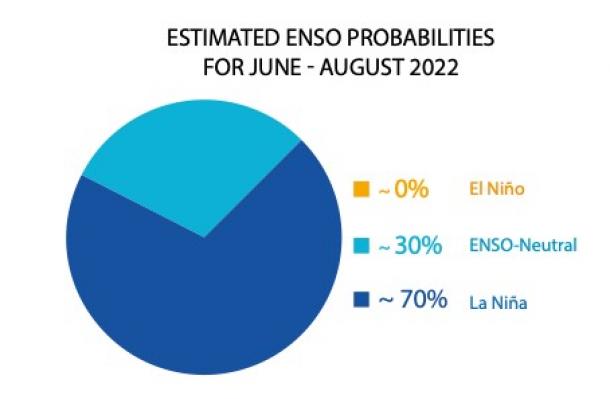
Graphic credit: WMO
“ WMO is providing tailored support to the humanitarian sector – as witnessed by a recent multi-agency alert on the worsening drought in East Africa. Improved seasonal forecasts are pivotal in this because they help plan ahead and gain substantial socio-economic benefits in climate sensitive sectors like agriculture, food security, health and disaster risk reduction, “ said Prof. Taalas.
“In addition to improving climate services, WMO is also striving towards the goal that everyone should have access to early warning systems in the next five years to protect them against hazards related to our weather, climate and water,” he said.
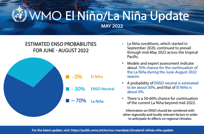
The current La Niña event started in September 2020 and continued through mid-May 2022 across the tropical Pacific.
There was a temporary weakening of the oceanic components of La Niña during January and February 2022, but it has strengthened since March 2022.
WMO Global Producing Centers for Long Range Forecasts indicate that there is about a 70% chance of the current La Niña conditions extending into boreal summer 2022, and about 50-60% during July-September 2022.
There are some indications that the probability may increase again slightly during the boreal fall of 2022 and early boreal winter of 2022-23.
Global Seasonal Climate outlook
El Niño and La Niña are major – but not the only – drivers of the Earth’s climate system.
In addition to the long-established ENSO Update, WMO now also issues regular Global Seasonal Climate Updates (GSCU), which incorporate influences of all other major climate drivers such as the North Atlantic Oscillation, the Arctic Oscillation and the Indian Ocean Dipole.
The Global Seasonal Climate Update is based on forecasts from WMO Global Producing Centres of Long-Range Forecasts and is available to support governments, the United Nations, decision-makers and stakeholders in climate sensitive sectors to mobilize preparations and protect lives and livelihoods.
Despite the stubborn La Niña in the equatorial central and eastern Pacific, widespread warmer than-average sea-surface temperatures elsewhere are predicted to dominate the forecast of air temperatures for June-August 2022. However, the extent and strength of predicted warming is less than during March-May 2022, according to the GSCU. Models indicate increased chance of negative Indian Ocean Dipole (IOD) over June-August 2022.
Precipitation predictions are similar to typical rainfall effects of La Niña.
Click the link to read the article on the NASA website:
The rugged, steep Rocky Mountains rise abruptly in the middle of Colorado, splitting the state roughly in half between the western high country and the eastern plains. The extreme contrast of these landscapes also brings an extreme disparity in water.
The Western Slope receives 80 percent of the state’s precipitation, as weather systems rising to cross the continental divide shed their loads of rain and snow before moving east. Water that falls to the west of the divide drains toward the Pacific Ocean, while water that falls to the east runs toward the Gulf of Mexico and Atlantic.
The plains of eastern Colorado, however, are semi-arid. In 1820, explorer Stephen Harriman Long—for whom Long’s Peak is named—famously dismissed it as a “Great Desert” unsuitable for agriculture. But the sandy, loamy soil can make fertile farmland when irrigated.
Grand River Ditch
In the mid- to late-19th century, the Gold Rush and the arrival of the railroad brought an influx of settlers to Colorado, including ranchers and farmers. Then in the 1880s, the plains received higher-than-average precipitation. The new settlers plowed under native drought-resistant grasses and used eastern farming techniques to grow wheat and corn, practices that would later contribute to soil erosion and the Dust Bowl.
When drier conditions returned, the residents looked to the Rocky Mountain snowpack and the Colorado River, then known as the Grand River, as a reliable source of water for irrigation. One of the first efforts to tap that supply was the Grand River Ditch. Beginning in 1900, the ditch diverted water from the Never Summer Mountains through Poudre Pass and into the Cache la Poudre River.
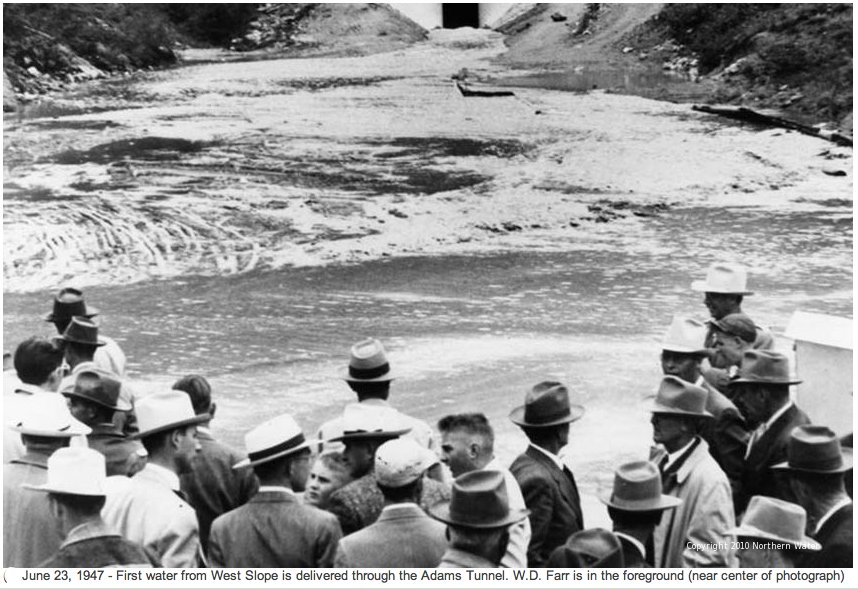
First water through the Adams Tunnel. Photo credit Northern Water.
In the early 1930s, during the Great Depression and the Dust Bowl drought, farmers and their representatives formed the Grand Lake Committee and conceived a more ambitious plan to divert water from the Western Slope of the Rockies and connect the Colorado and Big Thompson rivers. After much negotiation, construction of the Colorado-Big Thompson Project was begun by the U.S. Bureau of Reclamation in 1938. By the time it was completed and declared fully operational in 1957, it comprised 18 dams, 12 reservoirs, six hydroelectric plants, 95 miles (150 kilometers) of canals, and 35 miles (55 kilometers) of tunnels. The most critical of these is the tunnel that runs 13 miles (21 kilometers) under Rocky Mountain National Park and was named for U.S. Senator Alva B. Adams, who championed the project in Congress.
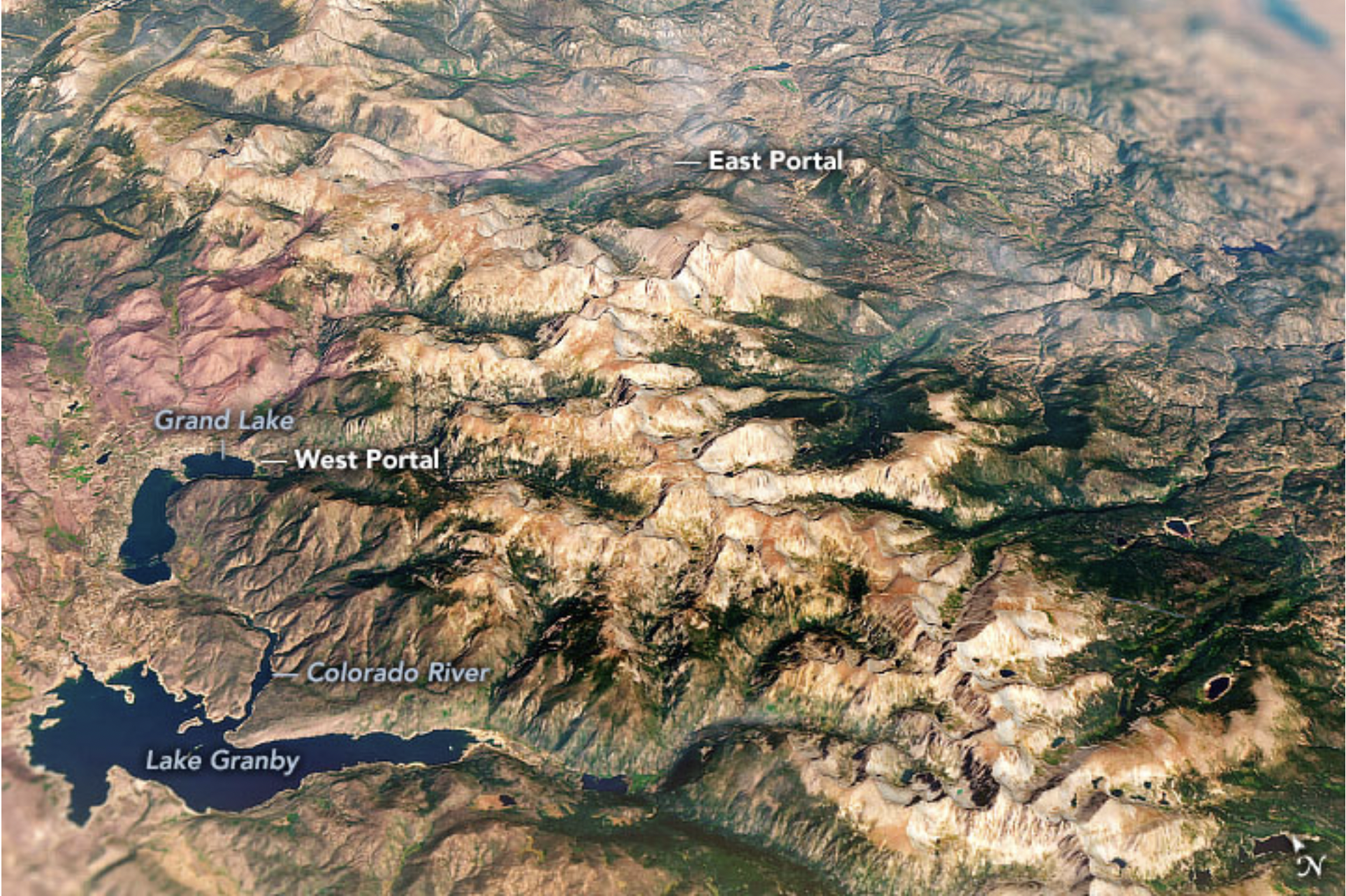
In 1940, two teams of workers began tunneling from either side of Rocky Mountain National Park: one from the West Portal at Grand Lake and one from the East Portal southwest of Estes Park, Colorado. In 1944, when the drilling teams met thousands of feet below the continental divide, the two sides of the tunnel were misaligned by just the width of a penny. The complex task of lining the 9.75-foot (3-meter) diameter tunnel with concrete took a few more years before first water flowed through the tunnel in 1947.
The portals are visible in the image above, which was acquired on September 2, 2021, with the Operational Land Imager (OLI) on Landsat 8 and overlain with topographic data from the Shuttle Radar Topography Mission (SRTM).
Photo credit: NASA
Snowmelt and runoff collected in Lake Granby is pumped to a canal that flows into Shadow Mountain Reservoir and Grand Lake, where it enters the West Portal of the Adams tunnel. Upon exiting the East Portal, the water flows into the Wind River toward Mary’s Lake, then proceeds through other tunnels and canals to multiple Front Range reservoirs. Between the West and East portals, the tunnel’s elevation drops 109 feet (33 meters). Driven by the force of gravity, water flows through the tunnel at a rate of 550 cubic feet (15.5 cubic meters) per second—traveling the length of the tunnel in about two hours.
It was a $160 million feat of civil engineering (roughly equivalent to $2 billion in today’s dollars). But it was not achieved without some controversy. Many residents of the Western Slope felt they were not being adequately compensated for the loss of water. Conservationists feared the project would despoil the natural beauty of Rocky Mountain National Park. The project proceeded after officials reached an agreement to construct the Green Mountain dam and reservoir to store water on the Western Slope, and to move the tunnel portals outside the boundaries of the national park.
Today, the Colorado-Big Thompson project delivers 200,000 acre-feet of water a year to northeastern Colorado, quenching the thirst of one million residents and irrigating more than 600,000 acres of farmland. Although the diversion project was initially built to irrigate farms and fields, it now also supplies water for cities and towns, industry, hydropower generation, recreation, and fish and wildlife. In Colorado, where more than 80 percent of the people live where only 20 percent of the precipitation falls, such transbasin water diversions have become a part of life.
NASA Earth Observatory images by Joshua Stevens, using Landsat data from the U.S. Geological Survey and topographic data from the Shuttle Radar Topography Mission (SRTM). Story by Sara E. Pratt.
Map of the Colorado-Big Thompson Project via Northern Water
Click the link to read the article on The Deseret News website (Amy Joi O’Donoghue). Here’s an excerpt:
Heat and dwindling water supplies have combined to result in an outbreak of a harmful algal bloom in the Virgin River watershed, according to the latest drought update issued by the Utah Division of Water Resources.
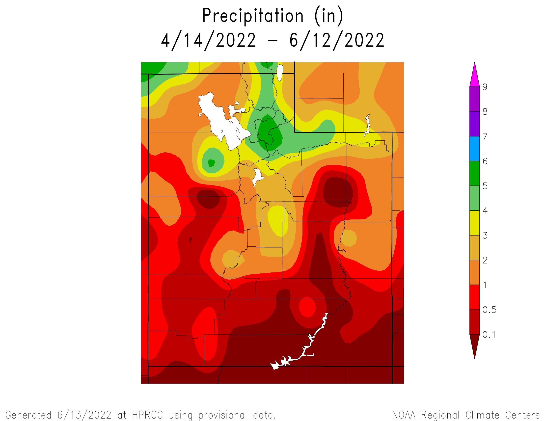
Southern Utah saw little to no precipitation in May and both Cedar City and St. George tied records for the driest May in 127 years.
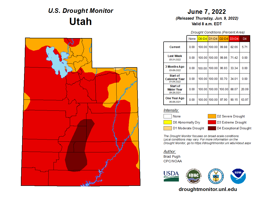
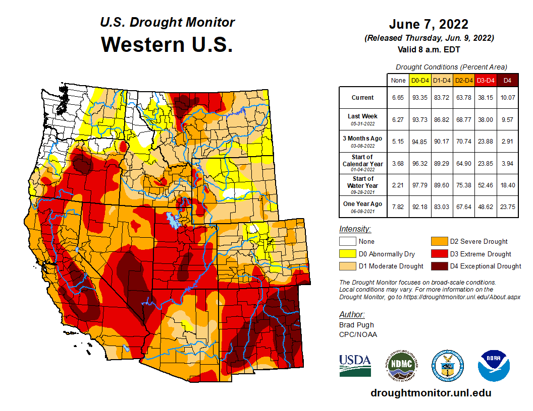
Utah Drought Monitor map June 7. 2022.
The U.S. Drought Monitor this week shows that nearly 6% of Utah has reached exceptional drought, the absolute worst category.
West Drought Monitor map June 7, 2022.
Other states in the West are faring no better in this generational drought, with Nevada with more than 21% of its land mass in the exceptional category and California approaching 12%.
Click the link to read the article on The Aspen Times website (Carolyn Sackariason). Here’s an excerpt:
For the third year in a row, the city of Aspen will continue to be under stage two water restrictions due to elevated drought conditions in Pitkin County. The U.S. Drought Monitor last month elevated Aspen and Pitkin County from abnormally dry to moderate drought conditions, according to Steve Hunter, the city’s utilities resource manager.
Map credit: The High Plains Regional Climate Center
Not only has the area experienced above-normal temperatures and below normal precipitation, Aspen started this spring with below average soil moisture. What that means is that drier soils will infiltrate snowmelt runoff reducing the amount reaching the streams, according to Hunter…
The city’s drought response committee has recommended in a staff memo to Aspen City Council that the municipality remain in stage two water restrictions, which it has been since the fall of 2020.
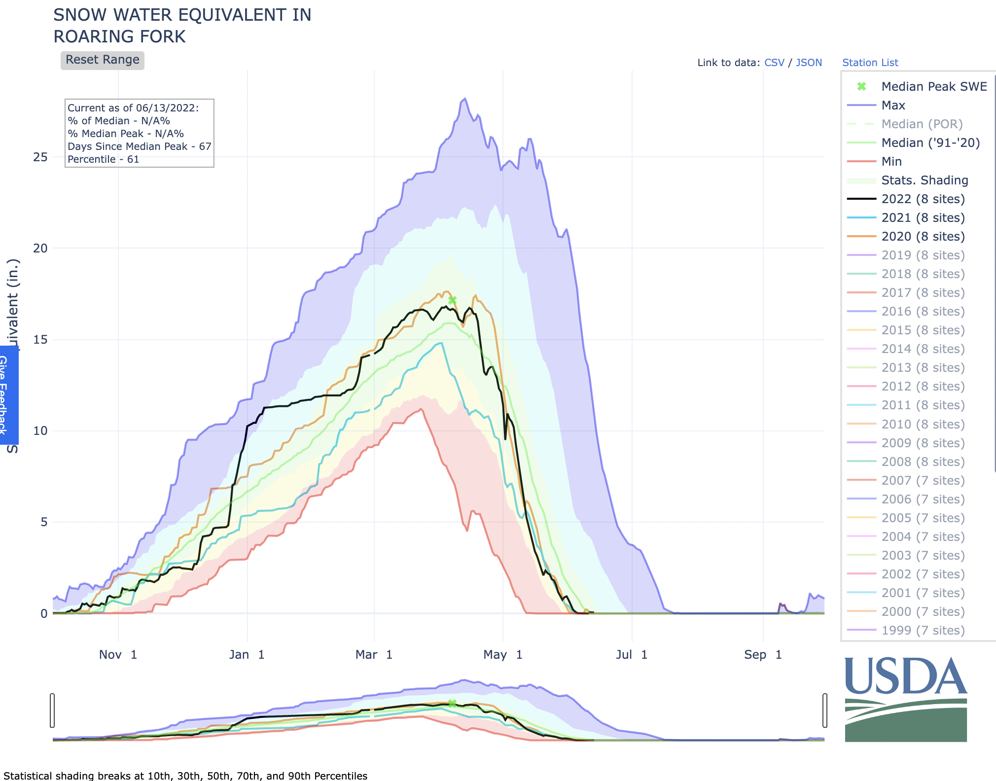
The 2021-22 snowpack was average to slightly above average for the Roaring Fork watershed as Western Colorado saw above average temperatures and below average precipitation in April and May, which have accelerated snowmelt, according to Hunter. Stream flows in the Roaring Fork watershed are estimated to be from 45% to 80% of average, and most rivers are predicted to have a smaller and earlier peak than normal.