Following a busy legislative session for the Colorado General Assembly, which ended May 11, Governor Polis signed several bills directing funding to numerous programs administered by the Colorado Water Conservation Board (CWCB).
“The Colorado Water Conservation Board is pleased by the support of the Colorado Legislative and Governor Polis for Colorado water issues in this past legislative session,” said CWCB Director Becky Mitchell. “This support is shown by the passage and signing of multiple bills that will do things like boost project funding for the Colorado Water Plan, help communities address watershed health issues and better prepare for future wildfires, and allow for so many other critical water programs to continue with needed funding.”
Below is a summary of signed legislation affecting CWCB in 2022:
Goose Pasture Tarn. Photo credit: City of Breckenridge
Construction Fund Projects Bill House Bill 1316, or the Projects Bill, annually supports multiple programs that fall within the Construction Fund. Programs supported through this bill, among others, include: floodplain map modernization, weather modification permitting (cloud seeding), the Platte River Recovery Implementation Program, dam safety evaluations for reservoir enlargements, and the Colorado Water Plan Grant Program. This bill also for the first time includes funding from Proposition DD (taxes collected on sports betting in Colorado) to supplement Colorado Water Plan grant awards. Also unique to this year’s bill, it allows for CWCB to provide a low-interest loan to the Town of Breckenridge to rehabilitate the Goose Pasture Tarn Dam.
Wildfire Prevention Watershed Restoration Funding Bill House Bill 1379 directs $10 million for post-wildfire watershed restoration and wildfire mitigation grants, as well as $5 million for technical assistance for local governments when applying for additional federal funding and for hiring support staff.
Mrs. Gulch’s Blue gramma “Eyelash” patch August 28, 2021.
Turf Replacement Program Bill House Bill 1151 directs $2 million to CWCB to establish a new funding program to incentivize replacement of turf with water-wise landscaping. This voluntary program defines water-wise landscaping as a “water and plant management practice that emphasizes using plants with lower water needs.” Local governments, certain districts, Tribal Nations, and nonprofit organizations may apply to CWCB for funding to help finance their own existing turf replacement programs as well. More information about this pending program will become available in Spring 2023.
The Republican River basin. The North Fork, South Fork and Arikaree all flow through Yuma County before crossing state lines. Credit: USBR/DOI
San Luis Valley. In this perspective, S is on top. Costilla County is along the edge of the southeastern side of the Valley between the Sangre de Cristo sub-range known as the Culebra Mountains (on the E) and the Rio Grande (on the W); upper left quadrant within SLV on this map. Source: http://geogdata.scsun.edu.
Groundwater Compact Compliance Bill Senate Bill 028 creates the groundwater compact compliance and sustainability fund to help finance groundwater use reduction efforts in the Rio Grande River Basin and the Republican River Basin (such as buying and retiring irrigation wells and irrigated acreage in these river basins). Specifically, the bill appropriates $60 million to CWCB to administer the fund and its intended efforts in coordination with the Division of Water Resources, the Rio Grande Water Conservation District, and the Republican River Water Conservation District.
This map shows the 15-mile reach of the Colorado River near Grand Junction, home to four species of endangered fish. Map credit: CWCB
Species Conservation Trust Fund Senate Bill 158 appropriates $6 million for conservation programs designed to protect threatened or endangered native species. Funding is allocated to programs through the Colorado Department of Natural Resources, and this bill includes $1.9 million for the Platte River Recovery Implementation Program, $800,000 for upper Colorado River endangered fish recovery and San Juan River Basin recovery implementation programs, and $250,000 for Ruedi Reservoir water releases for environmental benefits on the15-mile reach of the Colorado River.
Governor Polis signs SB22-028 at the Rio Grande Conservation District office in Alamosa. Photo credit: CWCB
Observed upper 2000 m ocean heat content and ocean salinity trends in the past half century. Data from IAP ocean dataset (http://www.ocean.iap.ac.cn/).
Click the link to read the article on the EurekAlert website (Institute of Atmospheric Physics, Chinese Academy of Sciences):
Even if society is able to slow all greenhouse gas emissions and get to “net zero” by mid-century as targeted by nations of the world in the UN Paris Agreement, there is a lag built into the climate system primarily as a result of ocean thermal inertia (also ice sheets) that means slow emerging changes such as deep ocean warming and sea-level rise will continue very long afterward.
Climate scientists argue in a new review paper that this means climate actions need to be established at multiple time scales. The paper has recently been published in Atmospheric and Oceanic Science Letters.
In the near term (∼2030), goals such as the United Nations Sustainable Development Goals (SDGs) will be critical. Over longer times (∼2050–2060 and beyond), global carbon neutrality targets may be met as countries continue to work toward reducing emissions. The climate actions need to extend far beyond the current period of focus to time scales of hundreds of years. On these time scales, preparation for “high impact, low probability” risks—such as an abrupt slowdown of Atlantic Ocean circulation and irreversible ice sheet loss—should be fully integrated into long-term planning.
The global ocean, which covers some 70 percent of the Earth’s surface, is slower to absorb and release heat than land. The large mass and heat capacity also means the ocean is much more capable of storing heat than air or land, and the ocean is hence the most important controlling component of the Earth’s climate.
This “ocean thermal inertia” offers both good news and bad news with respect to climate change. It means that the planet is not heating up as fast as it would without an ocean. But it also means that even once we halt greenhouse gas emissions by about 2050 to 2060, as laid out in the United Nations Paris Agreement—like a speeding train taking time to slow down once the brakes are hit—the climate system will still continue to change for a considerable amount of time afterward.
The ocean will keep on warming as heat is transported downwards into deeper ocean waters, and the climate system will only re-stabilize when that deep ocean stops warming and the Earth reaches an equilibrium between incoming and outgoing heat.
“This process means that while surface warming may stabilize at about 1.5-2℃ when global emissions reach net-zero emissions, sub-surface ocean warming will continue for at least hundreds of years, yet we normally only talk about climate action on the scale of a few decades to the end of the century at the most,” said lead-author, Prof. John Abraham, a mechanical engineering researcher with the University of St. Thomas in Minnesota, “That needs to change.”
As a consequence, a system of scientific ocean monitoring with that time-scale in mind needs to be developed. Besides subsurface temperature and sea level, the tracking of ocean climate trends such as pH, sea ice, ocean surface heat flux, currents, salinity, carbon, will require long-duration consistent and calibrated measurements, and compared with temperature, these essential climate variables are currently much less observed.
“Changes to the ocean will also continue to impact extreme weather over these longer periods, as well as sea-level rise.” said Prof. Lijing Cheng, an ocean and climate scientist from Institute of Atmospheric Physics, Chinese Academy of Sciences. “And infiltration of sea water into fresh water supplies can affect coastal food supplies, aquifers, and local economies. Other impacts that are connected to ocean warming and so need to be considered for the very long term include more damaging storm surges, coastal erosion, marine heatwaves, ocean acidification, and marine oxygen depletion.”
“Clearly this later group of measures will take a much longer time to implement but will also provide much longer lasting benefits”, added Pennsylvania State University climatologist Michael E Mann, another co-author of the paper. “Multi-scale adaptation practices like this should be considered throughout the globe.”
Finally, the researchers argue, societies need to begin to consider ensuring they are resilient in the face of “high impact, low probability” events (an unlikely event that would have significant consequences if it happens), such as an abrupt slowdown of Atlantic Meridional Overturning Circulation, large methane emissions from the seabed or thawing permafrost, passing a tipping point for losing a major ice sheet, or an abrupt shift and transition of ocean ecosystem including a major extinction event.
Moving forward, the researchers hope to connect with key decision-makers, city planners, and vulnerable communities that will need to be involved with such very long-term social decision-making to ensure that are basing their conclusions on sound climate and ocean science.
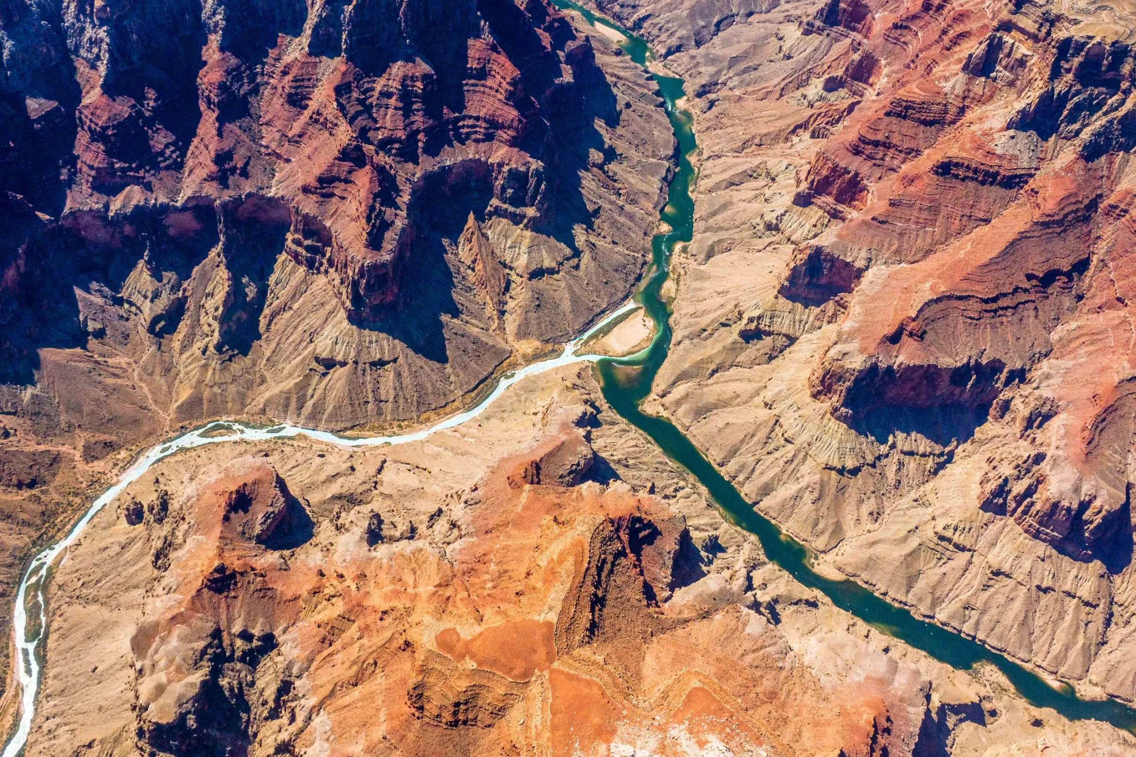
The confluence of the Colorado and Little Colorado rivers in the Grand Canyon, shown here in a September 2020 aerial photo from Ecoflight, represents an area where the humpback chub has rebounded in the last decade. That progress is now threatened by declining water levels in Lake Powell, which could lead to non-native smallmouth bass becoming established in the canyon. CREDIT: JANE PARGITER/ECOFLIGHT
As climate change continues to shrink the nation’s second-largest reservoir, water managers are scrambling to prevent the release of an invasive fish into the Grand Canyon.
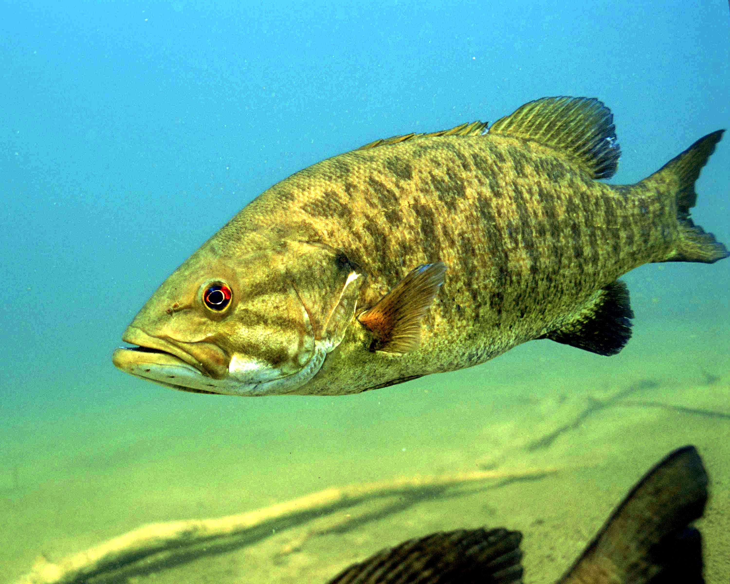
Smallmouth bass, a voracious predator and popular game fish, have been introduced into reservoirs throughout the Colorado River basin, including Lake Powell. The looming problem now is that as lake levels drop to historically low levels, the invasive fish are likely to escape beyond Glen Canyon Dam, threatening endangered fish in the canyon, whose populations have rebounded in recent years.
Smallmouth bass are a warm-water-loving species, hanging out in the top part of the water column, which is warmed by the sun. Until recently, the intakes for turbines at Glen Canyon Dam had been lower in the water column, where colder temperatures kept the fish away. But as the lake level falls, the warmer water band containing the smallmouth bass is sinking closer to the intakes, making it more likely that they will pass through the dam to the river below.
Warmer water below the dam also means a more ideal environment for the bass, which thrive in temperatures above 61 degrees Fahrenheit (16 degrees Celsius).
“With the levels we are expecting to get to this coming year, water temperatures are going to be warmer than they’ve been in 52 years in the Grand Canyon,” said Charles Yackulic, a research statistician with the U.S. Geological Survey’s Grand Canyon Monitoring and Research Center.
The research center has been modeling the likelihood that smallmouth bass will become established below the dam under different scenarios and providing that information to decision-makers and water managers.
Jack Schmidt, a Colorado River researcher at Utah State University and former director of the research center, co-wrote — along with Yackulic and others — a March 2021 paper that sounded the alarm that future warming is likely to disproportionately benefit nonnative fish species to the detriment of native species. The problem from which all others stem, including the changing fish communities, and the reason Powell is so low in the first place is the climate-change-driven supply-demand imbalance, Schmidt said.
Annual CO2 emissions from fossil fuels, by world region
“If we are going to continue to load the atmosphere with carbon such that the atmosphere warms and the runoff in the Colorado River keeps getting lower and if we are going to keep consuming water, … then you can only play this game of staving off the inevitable for so long before it’s game over,” he said.
The Colorado River Water Conservation District spans 15 Western Slope counties. Voters across the district are considering a mill-levy increase that would raise the River District’s budget by $5 million, funding a variety of water-related projects. Colorado River District/Courtesy image
Click the link to read the article on the Summit Daily website (Eliza Noe). Here’s an excerpt:
Community Funding Partnership’s accelerator grants are designed to help Western Slope water users build a competitive application for federal funding. This includes support in grant-writing, feasibility, design, preliminary environmental review, benefits analysis and engineering. The Colorado River District will consider supporting up to 85% of funding needs for this limited funding opportunity.
Grant deliverables must include a timely application to a federal funding opportunity that must be submitted by Dec. 31, 2023 and in no cases later than Dec. 31, 2024. Priority will be given to applications targeting a 2023 federal funding round. For more information, visit http://ColoradoRiverDistrict.org.
Applications for the Community Funding Partnership grants are due Aug. 1.
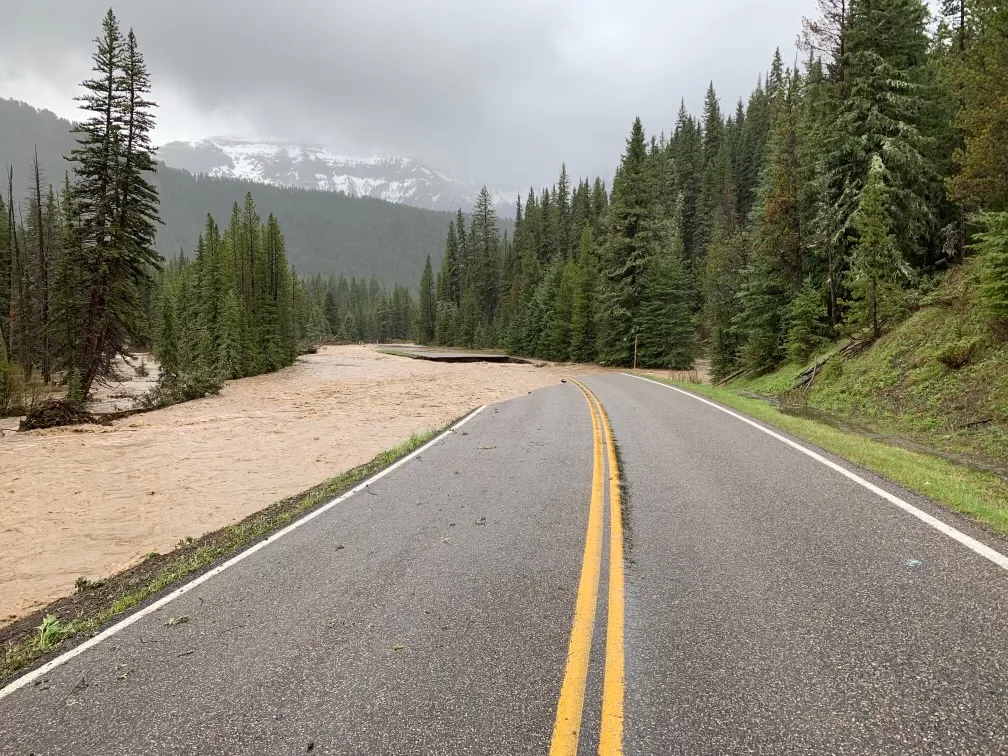
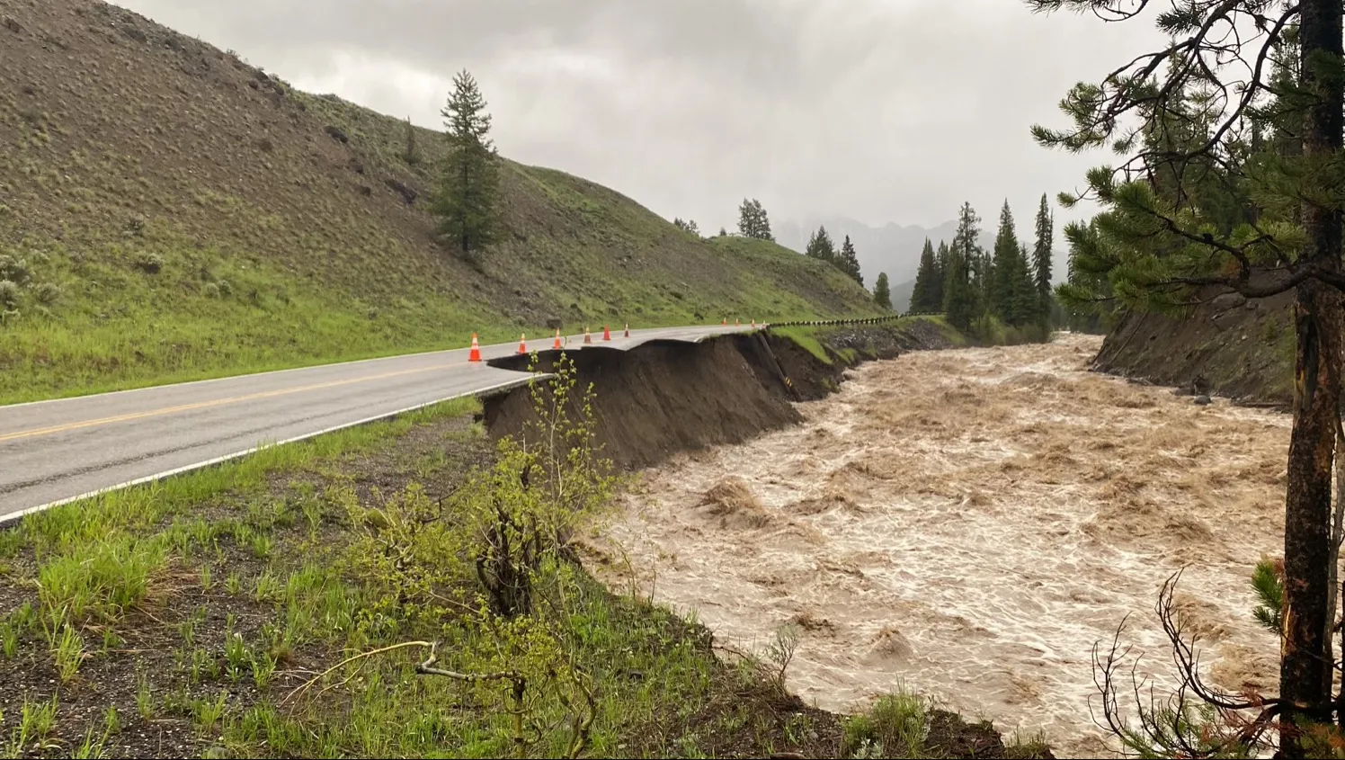
Yellowstone National Park’s Northeast Entrance Road washed out near Soda Butte Picnic Area on June 13, 2022. (National Park Service)
Click the link to read the article on the WyoFile website (Mike Koshmrl):
Unprecedented precipitation and flooding clobbered Yellowstone National Park starting Sunday, destroying bridges, making roads impassable, stranding scores of people and wreaking untold havoc on infrastructure within Northwest Wyoming’s tourism engine. The scope of the damage prompted park officials to close all park entrances Monday.
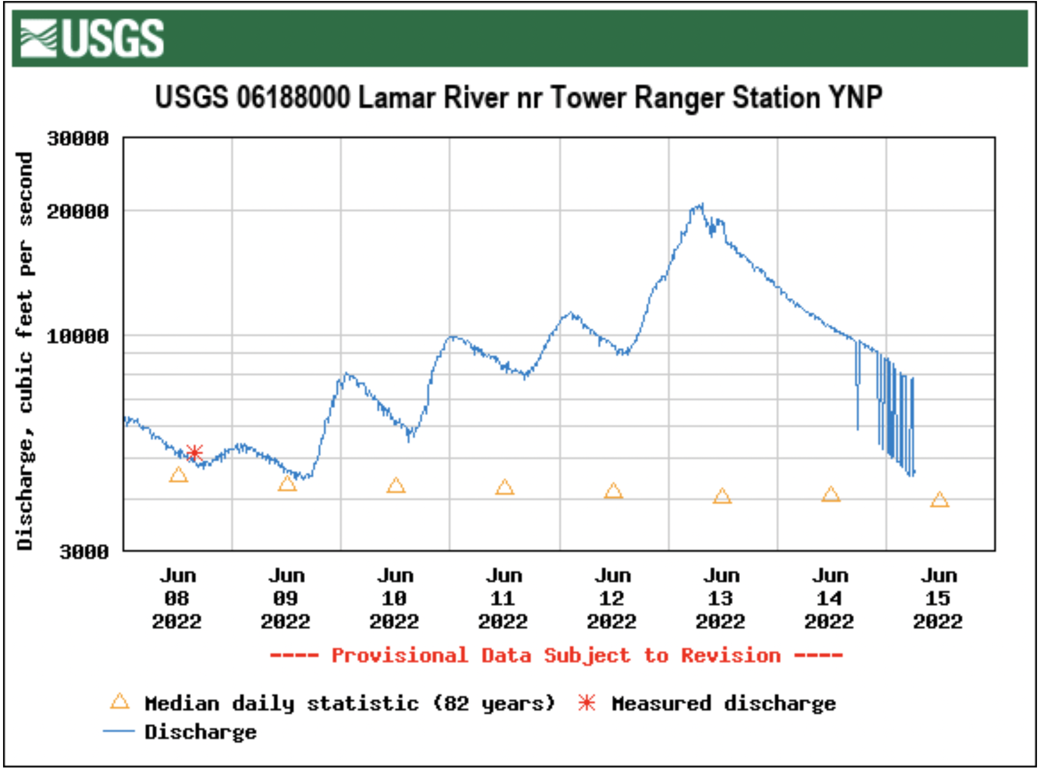
A U.S. Geological Survey gauge on the Lamar River near the Tower Ranger Station tells the tale of the remarkable weather event. The tributary to the Yellowstone River on Monday topped 18,000 cubic feet of water per second, which surpassed the previous daily record by nearly 50%. The Lamar rose so high that its peak water level, 17 feet over the riverbed, surpassed the gauge’s “operational limit” by 2 feet, and the water level was 5 feet higher than during any other time in 82 years of record keeping.
“It’s down to 15.5 feet right now, so at least it’s coming down,” National Weather Service meteorologist Jason Straub said Monday morning.
The weather calamity comes on the heels of an exceptionally dry winter, Natural Resources Conservation Service hydrologist Eric Larsen said. There was a record-low April 1 snowpack in the Yellowstone River headwaters, but that snow stuck around because of a wet, cool spring. Sunday and Monday’s torrential rains melted much of that snow, and the combined precipitation overwhelmed the waterways coursing through and surrounding the park.
“All the streamflows that would have been running over the last month, it’s all coming off right now, quickly,” Larsen said.
The Lamar River’s historic June 2022 flows eroded away the Northeast Entrance Road, which connects Yellowstone National Park headquarters in Mammoth Hot Springs with Silver Gate and Cooke City, Montana. (Yellowstone National Park)
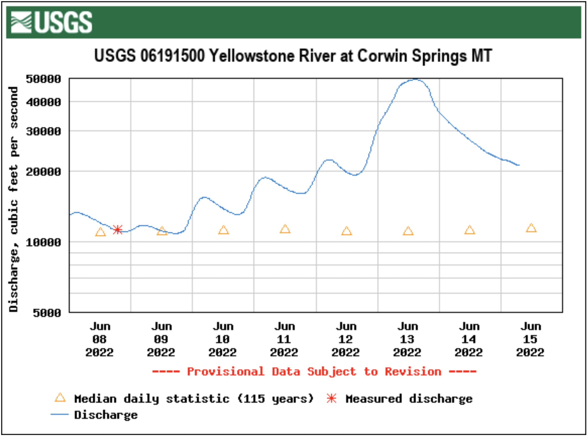
Flows are setting new hydrological high-water records in the Yellowstone River headwaters and well downstream into Montana.
“The Corwin Springs gauge on the Yellowstone, which is just upstream of my house, hit like 52,000 CFS, which is way higher than it’s ever been before,” Larsen said.
“It wiped out the Carbella bridge,” he said of the raging Yellowstone River.
Infrastructure in Yellowstone took such a beating that the National Park Service took the extraordinary step of shutting down all entrances into the park midmorning Monday. Park gates won’t open to inbound traffic Tuesday or Wednesday, officials announced in a press release.
“Due to record flooding events in the park and more precipitation in the forecast, we have made the decision to close Yellowstone to all inbound visitation,” Superintendent Cam Sholly said in a statement. “We will not know the timing of the park’s reopening until flood waters subside and we’re able to assess the damage throughout the park. It is likely that the northern loop will be closed for a substantial amount of time.”
The community of Gardiner, Montana — home to many Yellowstone headquarters staffers — was “currently isolated,” as of Sholly’s midday statement: “We are working with the county and State of Montana to provide necessary support to residents, who are currently without water and power in some areas.”
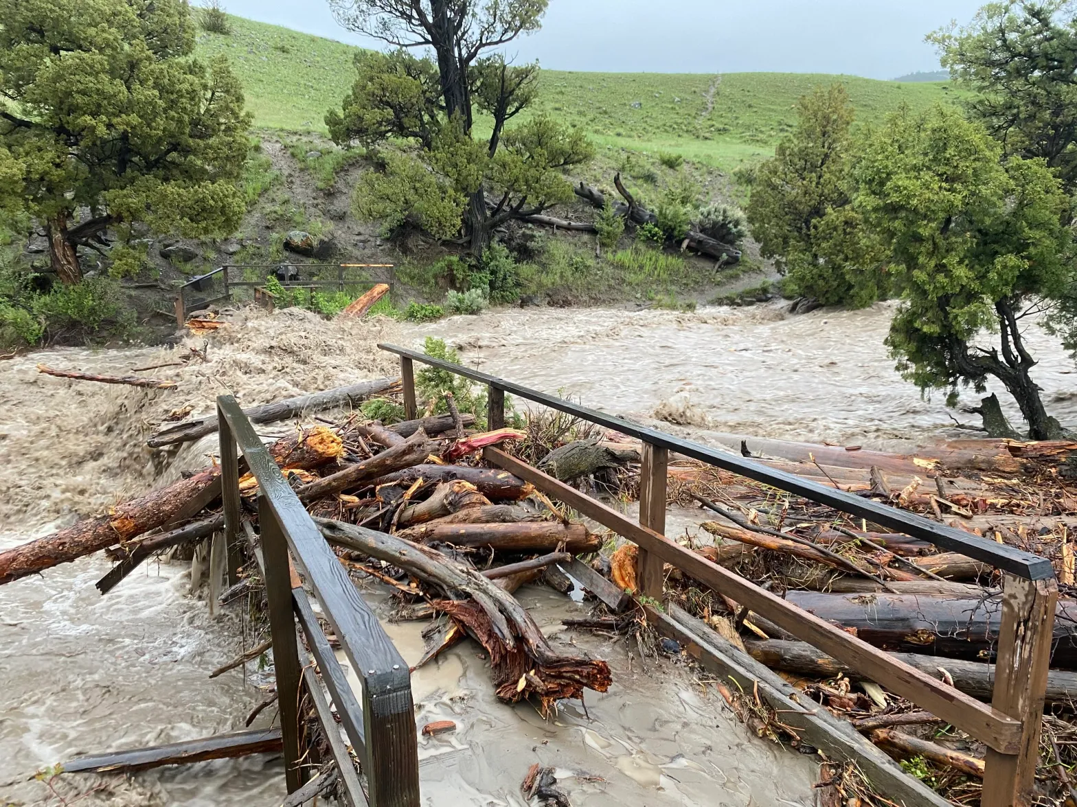
A footbridge across the Gardner River along the Rescue Creek Trail was totally destroyed by the flooding event in Yellowstone National Park on June 13, 2022 (Yellowstone National Park)
Evacuations took place within the park and in locations just outside.
The Cooke City-Silver Gate Volunteer Fire Department reported that there was “major flooding” in those two neighboring communities and that the Bannock Bridge in Cooke City is “gone.”
Silvergate was evacuated at 3 a.m. Monday, a host for the Beartooth Cafe told WyoFile.
There were also overnight evacuations in the Roosevelt area, according to Yellowstone visitors who posted online.
Yellowstone’s southern loop fared better initially, but was still being evacuated over the course of Monday, Sholly said in the statement. That’s due, he said, to “predictions of higher flood levels” and “concerns with water and wastewater systems.”
The rain that fell in Yellowstone Sunday and Monday sailed past daily records, Straub said. A rain gauge on the Gibbon River near Norris Junction tallied 1.63 inches of precipitation by 9 a.m. Tuesday. A site on the north side of Yellowstone Lake recorded up 1.75 inches, beating the old daily record, 0.43 inches, by more than 400%, he said.
“Single day observations over an inch are very rare,” Straub said. “We were already getting snowmelt, and add this 1 to 2 inches of rainfall and it started flowing fast into the valleys.”
Northwest Wyoming was forecasting “periodic showers” into Tuesday, he said. Those rains could drop “a tenth or two-tenths” of precipitation at a time, but should abate by Tuesday evening.
In the meantime, Straud cautioned area travelers to make good choices.
“Keep away from any flooded roads,” he said, “and don’t go around barriers.”
It’s all but assured there will be longer-term impacts to commerce and business in Yellowstone, said Mike Keller, general manager for the park’s largest concessionaire, Xanterra.
“The road between Mammoth and Gardiner is pretty much gone in several places,” Keller said. “It’s completely eroded, plus into the hillside beyond. There are some roads in this park that are not going to reopen for a period of time.”
All of Xanterra’s guests in the park are in the process of being evacuated. Employees, for now, are being allowed to stay.
“We’ve closed everything in the park through Thursday night,” Keller said Monday afternoon. “We’re hoping to start opening things back up Friday, but the rivers still haven’t peaked yet.”
MIKE KOSHMRL
Mike Koshmrl reports from Jackson on state politics and Wyoming’s natural resources. Prior to joining WyoFile, he spent nearly a decade covering the Greater Yellowstone Ecosystem’s wild places and creatures.
WyoFile is an independent nonprofit news organization focused on Wyoming people, places and policy.
Severe flooding due to unprecedented heavy rain on snow is forcing the closure and evacuation of Yellowstone National Park.
Mudslides, rockslides and flooding are wiping out roads and bridges across the region.
Aerial view from the south of Hayman Fire June 30, 2002. Road traversing from left to right is U.S. Highway 24. Town of Manitou Springs is in lower part of photo, Colorado Springs to the right. Garden of the Gods park defined by three upright orange rock formations in right center just below smoke line. Creative Commons Attribution-Share Alike 4.0 International license.
When the Hayman Fire sparked in Colorado 20 years ago this week (June 8, 2002), it incinerated 138,000 acres of forest. Though many at the time thought it was an anomaly – burning bigger, faster and hotter than most fire managers thought possible and diminishing the natural vegetation’s ability to regenerate as a result— it turned out to be a harbinger of the region’s future fire regime. The lessons learned from the Hayman Fire, however, have led to systemic changes in forest management and post-fire restoration efforts that have helped many western communities recover from similarly uncharacteristic fires and begin to build more resilient forests.
For starters, the Hayman Fire brought much-needed attention to the effects of post-fire erosion and flooding. “It spurred us to action as we saw not only the effects of the fire, but the post-fire erosion and flooding that were more damaging than the fire itself,” Brian Banks, the South Platte River District Ranger, told the Pikes Peak Courier. That attention has prompted government agencies, utilities and even private companies to dramatically increase resources for post-fire restoration.
The White River National Forest in Colorado was recently allocated over $2 million for restoration work in the Grizzly Creek and Sylvan Fire burn areas. The funds are part of the 2021 Extending Government Funding and Delivering Emergency Assistance Act, which provided $85 million to the U.S. Forest Service’s Rocky Mountain region to recover and restore national forests, watersheds and communities impacted by 2020 and 2021 wildfires.
Using funds from the Forest Service’s 10-year strategy to confront the wildfire crisis and improve forest resilience, The Umpqua National Forest in Oregon partnered with the National Forest Foundation and the Arbor Day Foundation to plant 440,000 tree seedlings across the million-acre burn scar left behind by Labor Day fire.
But while money is always good, with so much acreage affected (20,000 acres within the Umpqua National Forest still need to be replated), new tools are needed to make a real impact. After the East Troublesome Fire tore through Colorado in 2021, crews used helicopters to re-seed and mulch 5,000 acres in the Willow Creek Reservoir watershed.
In New Mexico, crews working the Hermits Peak and Calf Canyon Fire started post-fire erosion control before the fire had even been fully contained.
In Arizona, a coalition of government agencies, nonprofits and businesses are collaborating to restore the wildfire burn scar left behind by the Bush Fire by rescuing cacti from construction sites and replanting them in affected areas.
At the University of California Riverside, ecologists are collaborating with the US Forest Service to develop strategies for the restoration of chaparral shrublands so that these biodiversity hotspots rebound with native plants after a fire. They’re also tracking the progress of burned conifer forests that were replanted with more drought-tolerant pine species that normally grow at lower, drier elevations.
To help in these replanting efforts, researchers at New Mexico State University’s Forestry Research Center saved precious seeds used to rebuild resilient forests and created models that predict the best locations to plant seedlings after wildfires. Additionally, the state’s Forestry Division and several universities submitted an $80 million proposal to the federal government for a reforestation pipeline that includes seed collection, seed sowing in nurseries and the location.
Of course, some landscapes are so irreparably altered that communities have no other choice than to adapt. “Hayman is one of the many examples we have from the western U.S. of those fires from around 2000 that, really, (the forest) is not coming back,” Camille Stevens-Rumann, the assistant director of the Colorado Forest Restoration Institute…“But it’s really important to acknowledge that it’s not a lost landscape. There’s still value to grassland or shrubland. And it’s up to us to make sure that that’s still a healthy ecosystem — even if we can’t reforest every part of it.”
After the Caldor Fire destroyed five Sierra-at-Tahoe ski lifts in 2020, “we’re no longer dealing with a pristine forest,” John Rice, the resort general manager, said. “We’ve got a burnt landscape, so how do we utilize the terrain and the natural resources to create a ski product that will be next level for people?” Other wildfire-affected landscapes in California are seeing a ‘gold rush’ of morel mushrooms that have a symbiotic relationship with burned trees. The influx of mushrooms is creating a market for commercial and recreational hunters.

 The Republican River basin. The North Fork, South Fork and Arikaree all flow through Yuma County before crossing state lines. Credit: USBR/DOI
 San Luis Valley. In this perspective, S is on top. Costilla County is along the edge of the southeastern side of the Valley between the Sangre de Cristo sub-range known as the Culebra Mountains (on the E) and the Rio Grande (on the W); upper left quadrant within SLV on this map. Source: http://geogdata.scsun.edu.


