Click the link to read the article on the Westminster Window website (Luke Zarzecki). Here’s an excerpt:
The biggest risk to Westminster’s drinking water is wildfires and algae blooms, according to Tom Scribner, water treatment superintendent with Westminster. The water flows from Loveland pass to Clear Creek to Farmers Highline canal and into the lake.
Borgers said wildfire risk is high.
“Unfortunately, Clear Creek is at a very high risk for having a catastrophic wildfire,” she said.
It is something the city is very aware of and Westminster is heavily involved with mitigating wildfire in the watershed, she said.
“If it were to get into Stanley Lake, Semper probably would have a hard time treating it. But we have the ability to divert water around Standley so that Semper is not having to treat that poor quality water,” Borgers said.
The Semper Water Treatment Plant was built in the 1960s and does not have the technology to treat wildfire contaminated water to make it drinkable, according to Scribner.
Standley Lake has about a year of water storage the city would use, she said. The city would be able to find a new, reliable source for drinking water in that year, she said. Standley Lake supplies water for Northglenn and Thornton as well as Westminster.
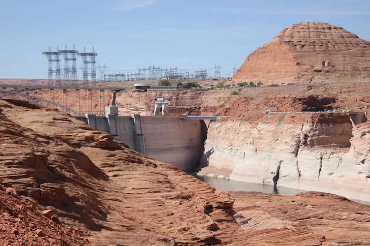
Glen Canyon Dam from the east side. Photo credit: Allen Best/Big Pivots
Click the link to read the article on the Big Pivots website (Allen Best):
Drought and aridification have exposed relics of construction of Glen Canyon Dam but also weaknesses of the 1922 agreement governing allocations. Can this document be salvaged?
In late May, I stood on the lip of Glen Canyon Dam, peering over the concrete edge to study the receding waters of Lake Powell. The reservoir was 75% empty.
Below I saw what appeared to be railroad tracks in a bench along the canyon wall. Acting dam manager Gus Levy said they were remnants of a concrete batch plant created to construct the dam in the early 1960s. They had emerged in February, the first time in nearly 60 years they had been above water.
The 21st century drought, now long and still deepening, coupled with aridification, has exposed problems in the compact governing allocations among the seven states in the Colorado River Basin. One clause in the Colorado River Compact would seem to saddle headwater states with taking up all the slack for reduced flows caused by climate change.
Now comes an important voice counseling a new view. Bruce Babbitt, the two-time governor of Arizona and then secretary of the interior in the Clinton administration, says it’s time to revisit this obligation.
“While I once thought that these aridification scenarios were kind of abstract and way out in the future, I don’t think that anymore,” Babbitt said in an interview with the Los Angeles Times.
Remains from a batch plant used in construction of Glen Canyon Dam emerged from the receding waters of Lake Powell in February. Photos/Allen Best
“It’s absolutely urgent that we start thinking now, while there’s time, about how we adjust the compact, the regulations, the necessary reductions, in the most careful way so that we limit the damage, which can really be extreme.”
“Huge,” tweeted Eric Kuhn, former manager of the Glenwood Springs-based Colorado River District, after Babbitt’s remarks were published.
At the Getches-Wikinson Center at the law school in Boulder next week, a conference subtitled “Hard Conversations about Really Complex Issues” will take up just what will constitute the thoughtful approach that Babbitt advises. The river and its tributaries provide water for up to 40 million people and some of its most productive farms across seven states.
Delegates from the basin states who gathered in Santa Fe, New Mexico, in 1922 assumed the river would deliver roughly 20 million acre-feet annually. That was unjustifiably optimistic. Evidence already existed of climate swings. The 20th century mostly failed those expectations, and the 21st century has been even stingier, delivering 17% less.
Jeff Lukas, a climatologist based in Lafayette who will speak at the conference, warns that even less water should be expected in coming decades.
“If forced to pick numbers right now, I’d go with 7%-25% lower by midcentury and 13%-33% less by the 2080s,” Lukas said.
End of natural drought might improve water flows, he adds, but only so much. Multiple studies attribute roughly half of the declined flows to human-caused greenhouse gases.
“But you don’t need a dire view of the future to know that the compact’s hydrologic assumptions and subsequent allocations are unworkable going forward,” he says. “I think the last 22 years alone have demonstrated that pretty clearly.”
Since 2007, the basin states have been patching up the compact with new agreements. A new sense of cooperation and shared sacrifice has become evident. Still untouched is that heart-burning stipulation that Colorado and the three other upper-basin states “will not cause the flow of the river at Lees Ferry to be depleted about an average of 75 million acre-feet for any period of 10 consecutive years …”
Lees Ferry is located in Arizona, above the Grand Canyon. Upstream 15 miles is Glen Canyon Dam, which generates hydroelectric power consumed in Basalt and Edwards as well as many other towns and farms in Colorado. However, the reservoir allows upper basin states to reliably deliver water to the lower-basin states and Mexico.
Brad Udall of Colorado State University’s Water Institute says the compact must be reinterpreted, not renegotiated. He believes delegates from upper-basin states who helped draft the compact a century ago would never have agreed to a fixed obligation in a changed climate. To assume so now also violates common sense.
The 19th century thinking was rooted in winners and losers, he says. Today, the intertwined economies of Southwestern states need solutions that maximize certainty even if the volume of water declines.
“The only thing that makes sense to me is that the two basins share this fundamental risk of declining flows, and I think that is a key part of a 21st century reinterpretation of the compact.”
Runoff from last winter’s snowstorms, if once again below average, has likely once again inundated those tracks I saw at Glen Canyon in May. They won’t stay submerged. Colorado River forecasters expect Powell’s resumed decline later this year. By January, it will be 80% empty.
Governor Jared Polis signed Senate Bill 22-114 into law Wednesday, authorizing the designation of fire-suppression ponds that will be exempt from the Prior Appropriation System established by the Colorado Constitution. The law allows up to 30 acres of fire-suppression ponds per county and bars the Colorado Division of Water Resources from requiring the replacement of water lost to evaporation from those ponds.
Chaffee County Commissioner Greg Felt, a member of the Colorado Water Conservation Board, supported the legislation…
[Terry] Scanga said the new law allows “clear injury to water rights. Our legislators can’t just wave a wand and magically say stealing water is okay.” The Upper Ark District, he added, will protest if someone tries to get a fire-suppression pond exemption in the Upper Ark Basin as it would injure water rights that the District was established to protect.
Scanga said Chaffee County already has a better system in place, requiring new subdivisions to install cisterns that store water for firefighting. Cisterns don’t lose water to evaporation, and they have firefighting hookups. Also, ponds ice over during winter months; cisterns don’t.
Felt said he can see why the new law is “problematic from a pure water rights perspective” but noted the increasing importance of considering forest health issues, a perspective reflected in support for the new law by “the big players in the South Platte Basin” – Denver Water, the Northern Colorado Water Conservancy District and Aurora.
“A very small and well-prescribed amount of injury is perhaps acceptable in order to mitigate the risk of catastrophic wildfire,” Felt said, noting that, to be eligible for the new designation, ponds “have to have been in place for at least 50 years.”