Lees Ferry streamgage and cableway downstream on the Colorado River, Arizona. (Public domain.)
September 21, 1923, 9:00 a.m. — Colorado River at Lees Ferry. From right bank on line with Klohr’s house and gage house. Old “Dugway” or inclined gage shows to left of gage house. Gage height 11.05′, discharge 27,000 cfs. Lens 16, time =1/25, camera supported. Photo by G.C. Stevens of the USGS. Source: 1921-1937 Surface Water Records File, Colorado R. @ Lees Ferry, Laguna Niguel Federal Records Center, Accession No. 57-78-0006, Box 2 of 2 , Location No. MB053635.
Click the link to read the article on the KUNC website (Luke Runyon). Here’s an excerpt:
State engineer Kevin Rein oversees the state’s water rights system. In a meeting with the Colorado River District board on Jul. 19, Rein assured members he would not be mandating conservation among their municipal, industrial and agricultural users. The district covers 15 counties in Western Colorado.
“There is nothing telling me to curtail water rights. There’s nothing telling me that I should encourage people to conserve,” Rein said…
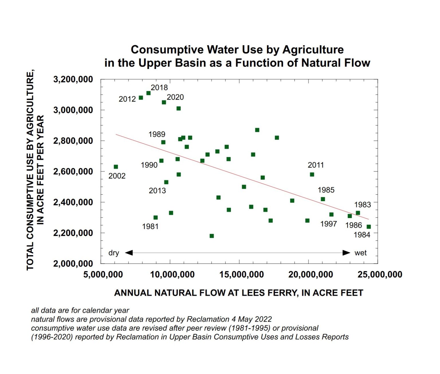
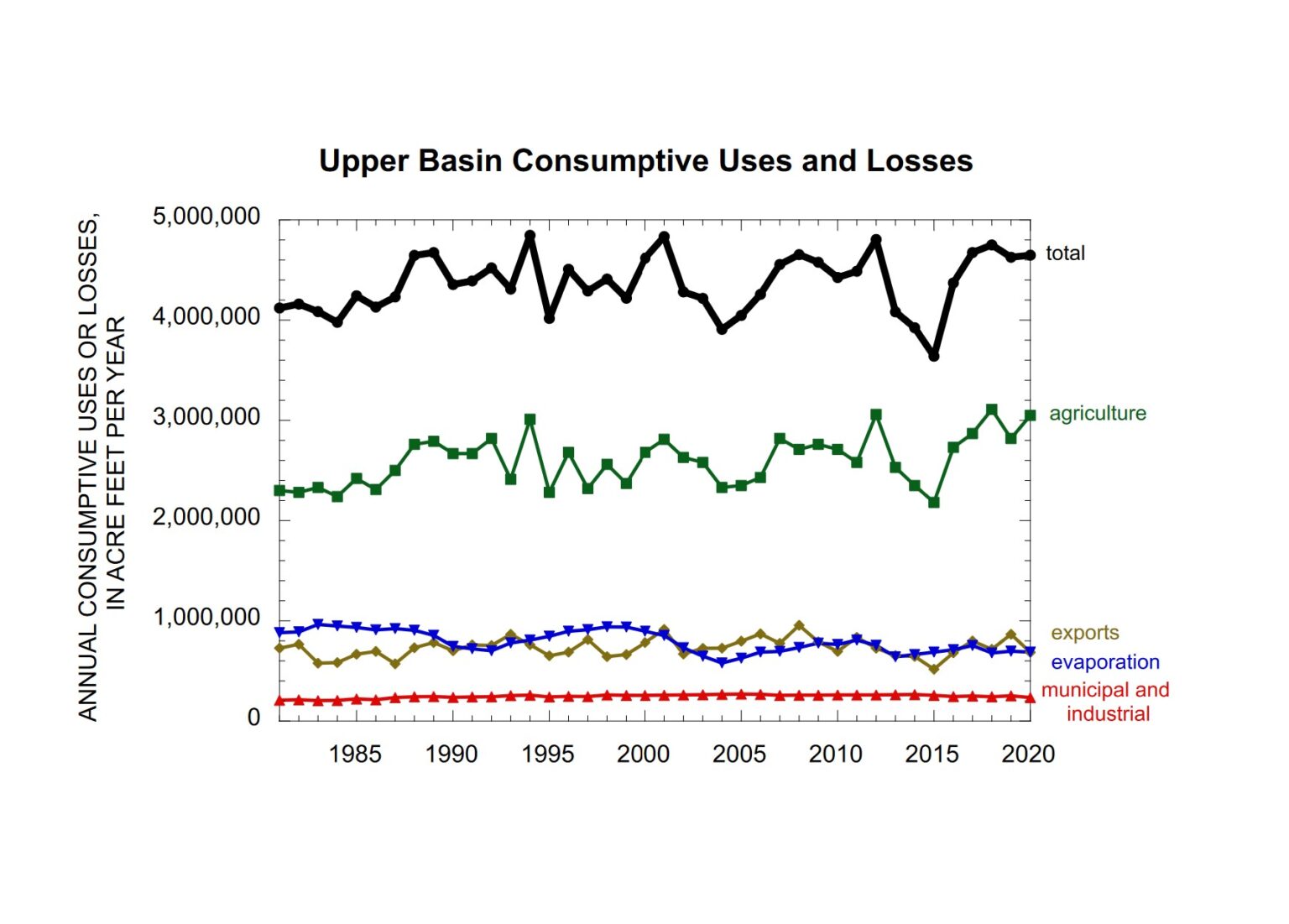
Colorado officials have argued the blame for the river’s supply-demand imbalance rests with California, Arizona and Nevada. Some doubt the federal government’s authority to demand the states use less water. The 1922 Colorado River Compact, a document that inflated available water within the entire basin, apportioned 7.5 million acre-feet of water to the river’s Upper and Lower Basins, respectively. In recent decades Lower Basin uses have exceeded that amount, while Upper Basin uses have remained below the apportionment.
“We’re way under our allocation of 7.5 million acre-feet a year,” Rein said. “So what does that mean? ‘We need to conserve.’ To me, that means that we don’t change our administration at the state engineer’s office.”
Rein said he has mandated water use reductions in other Colorado watersheds under the compact administration legal process. But the Colorado River has avoided that fate so far, he said. Without a solid legal basis, Rein said his hands are tied.
“If you have a beneficial use for water and you have a right to water and the right is physically and legally available, then I would encourage people to use your water right. It’s a public resource. It’s a property right. It’s part of our economy. It’s part of your livelihood,” Rein said.
“Somebody might tell me I’m wrong someday, but right now, I don’t see a legal basis for asking people to curtail,” Rein said…
Colorado River District general manager Andy Mueller said he wanted to know how the federal government was planning to tighten how it accounts for water use in the Lower Basin, including evaporation from reservoirs, a longtime complaint of Upper Basin leaders.
“It is extremely frustrating to see system water utilized for the benefit of the three Lower Basin states and us taking a hit for it. And now we are for the first time, frankly, about to be injured by it,” Mueller said.
Upper Basin leaders have resisted calls for specific amounts of conservation on the Colorado River. In a plan released last week, the four Upper Basin states — Colorado, Wyoming, New Mexico and Utah — instead call for the reinstatement of a conservation program that paid farmers to forgo water supplies, first tested in 2014.
Arizona monsoon cloud with lightning striking the beautiful Sonoran desert in North Scottsdale. Photo by James Bo Insogna. Title: Arizona Monsoon Thunderstorm. Taken on August 15, 2016. Used under a Creative Commons license.
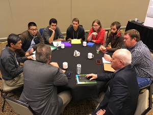
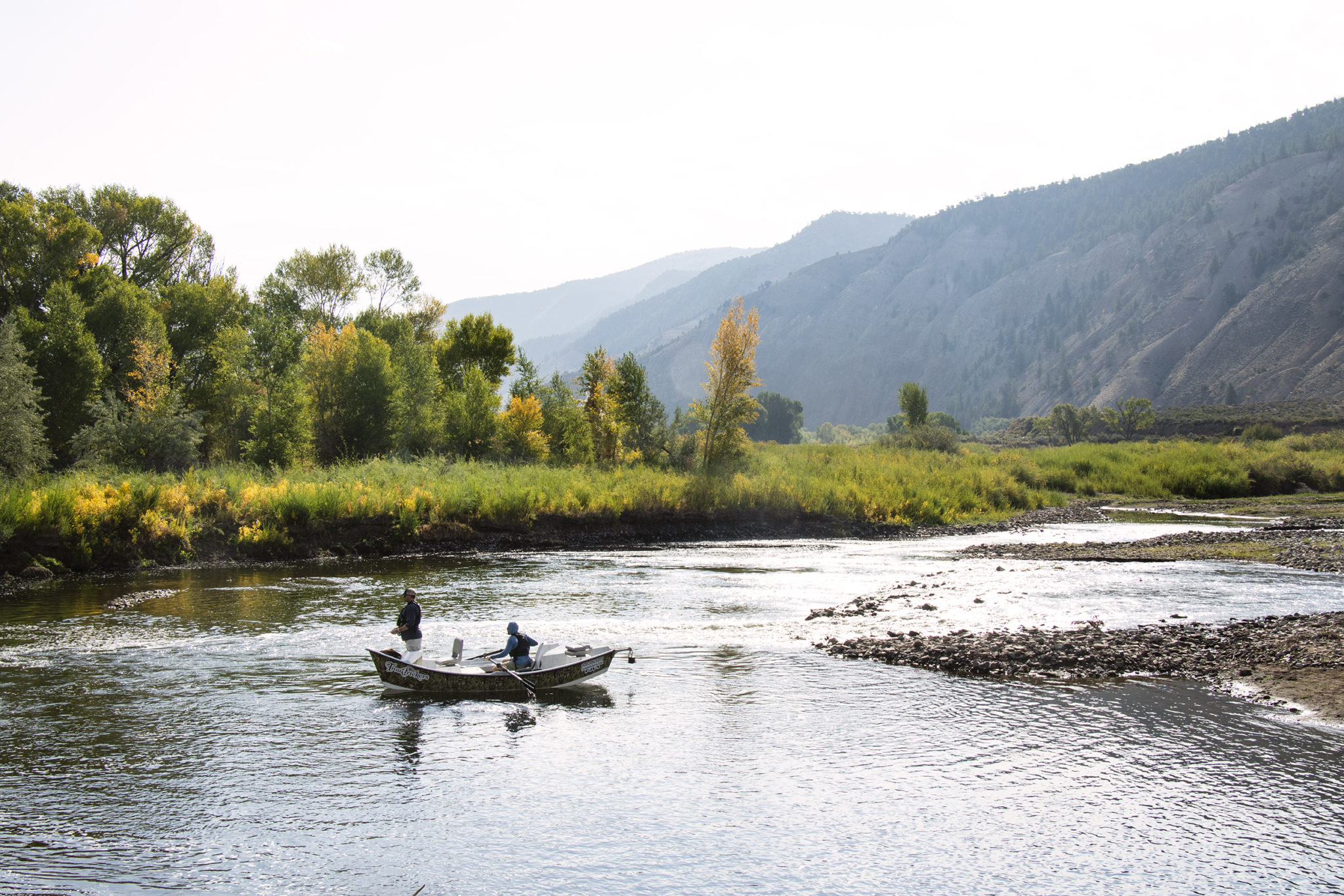
Don Meyer, Sr. Water Resource Specialist, and Dave “DK” Kanzer, Director of Science and Interstate Matters, gave a thorough hydrological report to the Board on July 20th. Their report focused on the current, productive monsoon cycle, storage in local reservoirs, and the low flows and high water temperatures observed in the Upper Colorado River headwaters.
Monsoons
“We’ve been enjoying some moisture from this monsoonal flume,” said Meyer. “It seems almost weekly.”
These frequent, often fast-moving bouts of moisture have improved soil moisture across the District and helped farmers and ranchers by also providing cloud cover which decreases evaporation and soil temperature.
“Is it helping with the overall drought conditions?” Kanzer asked. “Well, the answer is sort of. It’s not doing much for the Colorado River Basin system as a whole, but those afternoon rain showers have done wonders for our local water users.”
Reservoir Storage
Wet and cool conditions in April sustained the snowpack which also helped local reservoirs with water storage.
“The longer runoff is delayed, the more water ends up in the system,” Meyer said. “However, we are still below average.”
Water managers across the West Slope depend on higher flows during the spring runoff to fill reservoirs for release during hotter, drier months later in the summer. Healthy river ecosystems depend on high flows to flush sediment, however, so often larger amounts of water are passed during the natural runoff window to support fish health. Choosing how much and when to fill a reservoir of any size involves accounting for myriad variables. Accurate predictions and streamflow forecasts are an essential part of getting this balancing act right.
Meyer shared how Elkhead Reservoir, one of the two reservoirs managed by the River District, was a study in this complex process this summer. “Elkhead fill was a bit of a nail-biter this year.” Meyer said. “We were operating to reduce downstream erosion. To do this we try to store peak flows and release a lower, steadier amount of water, but we had some issue with the forecasts. In early May, we realized that we weren’t going to get those big, forecasted peaks, so we had to quickly reduce releases. Incorrect forecasts were really detrimental.”
No forecasts for streamflow or storage on the West Slope are above 80% for this summer.
“We often talk about the importance of accurate science and forecasts,” said Andy Mueller, General Manager of the River District. “Not having accurate data does have major impacts for the health of streamflow and the human communities.”
Director Kathleen Curry from Gunnison County shared the dire conditions facing Blue Mesa Reservoir which is barely half full after last year’s Drought Operations release to Lake Powell and this year’s unimpressive runoff.
“The whole system is really stressed.” Curry said. “Blue Mesa is filled with algae, and the river above that is warm and bright green. The fish from the 15-mile reach are so stressed, they are coming up the Gunnison to just below the Redlands Canal. It’s become very difficult for the system to meet all the needs.”
The 15-mile reach is a section of the Colorado River where streamflow in the summer is reduced by more than half due to agriculture and municipal diversions in Grand Valley.
High Water Temperatures
“This is a tale of two years,” said Meyer “In 2021, we had some really hot, unusual temperatures. Last year it was in June, and this year, they were just as bad, but came later in July.”
In mid-July, temperatures in the Colorado River between Kremmling and Catamount (two USGS gages which provide data on streamflow, water temperature, dissolved oxygen and particulate matter) indicated that the water temperature was well outside a healthy range for fish. In response to the spiking temperatures, Colorado Parks and Wildlife issued multiple voluntary fishing closures not only for stretches of the Upper Colorado River, but also for sections of the Eagle, Roaring Fork, Fraser, and Yampa Rivers to protect already-stressed, cold-water fish like trout.
Wolford Mountain Reserovir, and the Gore Range. Photo: Brent Gardner-Smith/Aspen Journalism
Anticipating these conditions, the Colorado River District chose to release approximately 200 acre-feet of water from Wolford Mountain Reservoir. The low streamflow conditions are due in part to climate change and earlier, hotter summer temperatures, inaccurate streamflow forecasts, and trans-basin diverters who continue to fill their reservoirs regardless of the hydrological conditions on the Western Slope.
“The issue is not our ag producers,” said Andy Mueller, General Manager of the River District. “The issue is that Front Range diverters continue to take their water no matter what the snowpack looks like. Streamflow drops, raising the temperature of the river and damaging the fish health and the economy of the West Slope.”
Marc Catlin, Director from Montrose County shared his perspective as well. “There is no one at this table who is doing as well as they are. They divert 100% of their right now matter what, no matter what the snowpack.”
According to Brendan Langenhuizen, Director of Technical Advocacy, local anglers and residents of Grand County were deeply appreciative of the District’s efforts to lower water temperatures. “I’ve received several voicemails. One was from an angler in the Vail Valley. He talked about the real economic impacts due to high water temperatures. Once the fishing closures go into place, they can’t run their business.”
Gallinas River watershed. Map credit: Hermit’s Peak Watershed Alliance
Click the link to read the article on the KOAT website (Nick Catlin). Here’s an excerpt:
Las Vegas is relying solely on its reservoirs to supply water, but it currently contains less than 50 days of water. Las Vegas normally relies on the Gallinas River as its primary water source. However, the Hermits Peak/Calf Canyon fires damaged thousands of acres of the watershed for the river. The city said the fires have caused large amounts of ash and debris to enter the river, preventing Las Vegas from pulling from its primary water source.
Click the link to read the in-depth article on the Colorado Springs Gazette website (Mary Shinn). Click through for the whole article and to view the photo gallery. Here’s an excerpt:
The same uncertainty facing [Nancy] Caywood’s family farm in Pinal County is widespread across the Colorado River basin following a Bureau of Reclamation announcement the seven states reliant on the river, including Colorado, need to conserve an additional 2-million to 4 million acre-feet of water next year to preserve the integrity of the stricken system, including power production in Lake Powell and Lake Mead. Colorado Springs Utilities relies on the river for 70% of its water and so it’s possible the community could be asked to conserve more as the whole basin tries to balance the needs of farms, cities and industry. Utilities has not received any clear direction from the state or other agencies yet and is not expecting much change next year, Kalsoum Abbasi, Utilities’ planning supervisor for water conveyance, told the board in July…
On Colorado’s Western Slope, growers with more junior rights have faced drought-driven uncompensated cutbacks and shutoffs in recent years and officials with the Colorado Water Conservation Board say that’s why major cuts to meet the Bureau’s goals should come from the Lower Basin states, such as California. Upper Basin states Colorado, New Mexico, Utah and Wyoming cut 1 million acre-feet of water use between 2020 and 2021 because of the drought conditions. The board did not have an estimate of how much had been cut in Colorado alone.
“Our water users are already really, really cut back,” said Amy Ostdiek, chief of the interstate, federal and water information section for the conservation board. For example, the Ute Mountain Ute Tribe in Southwest Colorado fallowed more than 4,000 acres because of drought conditions…
However, Colorado and the other Upper Basin states could achieve greater water savings by paying growers to leave land unplanted, a step known as demand management. Colorado policy makers want to avoid policies that permanently remove water rights from farmland, a practice known as buy and dry. The Upper Basin states said in a recent letter to the Bureau of Reclamation they would “consider” implementing demand management to meet the bureau’s goals. The bureau’s call for millions of acre-feet in conservation followed the first-ever Tier 1 cutbacks on the river that hit the Central Arizona Project hard this summer, showing how water shortages can play out…
Aerial photo – Central Arizona Project. The Central Arizona Project is a massive infrastructural project that conveys water from the Colorado River to central and southern Arizona, and is central to many of the innovative partnerships and exchanges that the Gila River Indian Community has set up. Public Domain, https://commons.wikimedia.org/w/index.php?curid=326265
As part of the Central Arizona Project deal, Arizona “would suffer losses before California would have to give up one drop of water,” said University of Arizona Professor Jeff Silvertooth, who has researched the profitability and sustainability of Southwest agriculture. “They never envisioned the possibility of what we are experiencing today.”
Climate change has heightened the problem. While the basin has seen droughts with similar levels of low precipitation in the past, higher average temperatures further stress the environment, said Russ Schumacher, state climatologist…
…the Central Arizona Project’s regular supply was cut by 30%, or about 500,000 acre-feet this year. The project cut agricultural deliveries by 65%, while urban areas received their full water deliveries. The cuts left farmers who are reliant on the canal to fallow large portions of land in Pinal County, near Caywood’s farm…While Central Arizona Project users are among the most junior on the river, Yuma, Ariz., a powerhouse of leafy green vegetable production, and Mesa County in Colorado, famous for Palisade peaches, are among the most senior. Still, some of those users have made water conservation changes…
Colorado utilities support new approaches to conservation, because water saved by the Lower Basin can help preserve the levels in Lake Powell, said Todd Hartman, a spokesman for Denver Water. More study is needed to see how useful the N-Drip system would be in Colorado…Max Schmidt, with the Orchard Mesa Irrigation District, said he expects water will have to leave the Western Slope to meet cities’ needs. He noted that in the Grand Valley, development typically happens on less productive farmland that already has water rights. But on the Front Range development has relied heavily on water from other basins.
Orchard Mesa Irrigation District power plant near Palisade. Water from Colorado’s snowpack is distributed across the region through a complex network of dams, pipelines and irrigation canals. Photo credit: Orchard Mesa Irrigation District
Turbidity in the Colorado River is dropping to levels previous to major wildfires and mudslides that roiled Glenwood Canyon in 2020 and 2021, Silt Public Works Director Trey Fonner said…Whenever loose rock and dirt unearthed from heavy rainstorms barrel into the Colorado River — the main source of drinking and agricultural use for Silt, Rifle and Parachute — sediment increases. The measurement is called turbidity…Turbidity levels rose after the Grizzly Creek wildfire consumed more than 32,631 acres within Glenwood Canyon in 2020 and after a rare, 500-year rain event in summer 2021 caused massive debris flows in the same area…
Middle Colorado Watershed Council Executive Director Paula Stepp said one of the ways to mitigate turbidity relies on new measurement devices installed up and down the Colorado River. With water quality monitoring stations established by the USGS in Garfield County, data collected from these sites are used to warn downstream users. Though Glenwood Springs’ primary water source isn’t the Colorado River, the city has water monitoring stations at Veltus Park on the Roaring Fork River and at the confluence of the Colorado and Roaring Fork Rivers near Two Rivers Park. Three other stations are located in South Canyon, Silt and Rulison…
Recently, Silt used $200,000 in American Rescue Plan Act funds to pursue an engineering study on how it can better its methods of pulling water from the Colorado River. That study concluded the city needed at least $30 million to not only combat turbidity levels but better serve its growing population. One way to pay for water and wastewater treatment improvements falls on the $1 trillion bipartisan infrastructure bill passed by Congress in November 2021.
Click the link to read the article on the Summit Daily website (Eliza Noe). Here’s an excerpt:
This week, Copper Mountain Resort kicked off its carbon sequestration study, and over the next 10 years, scientists and resort leaders are hoping that ski slopes can contribute to the fight against the effects of climate change. The resort hosted a conservation summit on Wednesday, where Copper officials discussed the goals of the project with other ski industry and environmental leaders. Jeff Grasser, efficiency manager for Copper Mountain, said efforts have already been made to increase biodiversity of the land, but this study would continue meeting sustainability goals. Carbon sequestration is the process in which carbon dioxide is removed from the atmosphere and held in solid or liquid form. In this case, it would be in the soil, where most of the world’s carbon is stored. Grasser said the resort has developed a scientific-based study to prove that their efforts actually help increase the amount of carbon dioxide being taken out of the air…
Grasser said currently, the goal is to offset one gram of carbon per square meter. That would be about 50 metric tons of carbon per year. Specifically, he said that he is looking forward to seeing if the study could offset the resort’s backup motors for lifts since those are run by fossil fuels and are tested regularly to make sure they are functioning. Though it would not happen overnight, Grasser said building more biodiversity could help reach that goal…
Jennie DeMarco, assistant professor at Southwestern University in Texas, is a scientist assisting on the project and said that, in her work, she focuses on nature-based solutions. By doing restoration projects, people can increase carbon storage and avoid greenhouse gas emissions. She said the key with nature-climate solutions is that they can be implemented in a lot of different ecosystems. They are cost effective, she claimed, compared to new carbon-capture technology.
Just like any major disturbance, ski slopes can disrupt or degrade soils, which makes them less likely to store carbon. One solution that this project will study is adding compost to certain areas to improve soil health and encourage more sequestration and plant growth.
This image was taken during the peak outflow from the Gold King Mine spill at 10:57 a.m. Aug. 5, 2015. The waste-rock dump can be seen eroding on the right. Federal investigators placed blame for the blowout squarely on engineering errors made by the Environmental Protection Agency’s-contracted company in a 132-page report released Thursday [October 22, 2015]
Click the link to read the article on the Durango Telegraph website (Jonathan Romeo). Here’s an excerpt:
With the recent news that the Environmental Protection Agency agreed to pay New Mexico and the Navajo Nation more than $63 million for damages related to the Gold King Mine spill, some Coloradoans are asking: What about us?
“I just always question, should we have been louder, because holy smokes, that’s a lot of money,” La Plata County Commissioner Matt Salka said. “And it is concerning when $60 million-plus goes to communities at the end of the river, yet (Durango and Silverton) were the most heavily impacted.”
[…]
The “Bonita Peak Mining District” superfund site. Map via the Environmental Protection Agency
After the plume passed by, the communities closest to the headwaters – Silverton and Durango – decided not to pursue litigation against the EPA. Instead, they chose to push for the cleanup of mines that pock the mountains around Silverton and have degraded water quality in the Animas River since the heydey of mining in the late 1800s, early 1900s. And indeed, in fall 2016, a collection of historic mines in the area, including the Gold King, received a Superfund designation with widespread local support…
Downstream communities in New Mexico and on the Navajo Nation, however, went a different route. New Mexico sued the EPA in May 2016, with the Navajo Nation following suit a few months later. The $63 million settlement, announced in June, is now under question by upriver elected officials.
“Those are funds I would have liked to see go to the actual source of the issue,” Salka said. “We should be addressing the Superfund site, making sure water quality is good and preventing another mine blowout.”
[…]
While the sheer sight of the spill alarmed even the most involved members of groups such as the Animas River Stakeholders Group (a now-defunct organization of volunteers dedicated to protecting the health of the river), the fact that a mine blew out near Silverton wasn’t a shock. It has happened many times over the years. Looking at the long view: roughly 5.4 million gallons of acid mine drainage leaches into the Animas each day, compared to 3 million in the one-time Gold King blowout. The spill, however, was the catalyst that finally secured a Superfund designation for the mines draining around Silverton. In the past, some community members objected that a Superfund declaration carried a stigma that would imperil the town’s tourism economy and destroy any possibility of reviving the local mining industry. But after the Gold King blowout drew national attention, there was no stopping the momentum, and the Bonita Peak Superfund site was established. It’s composed of 48 historic mining sites around Silverton that are the biggest culprits of metal loading…
Prior to mining, snowmelt and rain seep into natural cracks and fractures, eventually emerging as a freshwater spring (usually). Graphic credit: Jonathan Thompson
It should be noted New Mexico also reached an $11 million settlement with Sunnyside Gold, the last operating mining company in Silverton, and is still pursuing a lawsuit against the EPA’s contractor…
The orange plume flows through the Animas across the Colorado/New Mexico state line the afternoon of Aug. 7, 2015. (Photo by Melissa May, San Juan Soil and Conservation District)
On the Navajo Nation, a different case was made about the Gold King Mine spill. From a Native American cultural perspective, waters are sacred, and the disturbing sight of a bright orange San Juan River had a traumatic impact on tribal members (not to mention the history of environmental injustice on tribes throughout North America). According to media reports, some farmers on the Navajo Nation refused to use San Juan River water for years after the spill…
That’s not to say Silverton and Durango were shorted. Both governments received some reimbursement for dealing with the spill itself. The EPA built a $1 million water treatment plant that continues to operate at a cost to the EPA of $2.5 million a year. And, the agency has spent about $100 million to date on the Superfund site and expects to spend significantly more in the coming years…
Since the Gold King Mine spill happened, a lot of money has been exchanged (and not exchanged: the EPA, for instance, denied liability for $1.2 billion in private damages, such as rafting companies that took a hit during the river closure, lost wages for the tourism sector and alleged damage to crops and livestock). EPA’s Basile added a separate lawsuit settlement will have Sunnyside Gold pay $41 million to the federal government and $4 million to Colorado, all to be used on top of the federal government’s $45 million for the Bonita Peak site…At the end of the day, however, local officials say the best payout of all would be improved water quality in the Animas River watershed. Yet, Brookie said it does sting to see the dollar amount going to a New Mexico community that may not necessarily have a case for claiming they were impacted by the Gold King Mine spill.
Coyote Gulch’s rented Tesla charging in Green River, Utah.
Saturday was a long day as we drove from Denver to Mesquite, Nevada. The route was all on I-70 and I-15. The Tesla charging network makes traveling along the interstate network worry free. We charged in Glenwood Springs, Colorado and Green River, Richfield, and Beaver, Utah. At every stop other Tesla vehicles were charging. There was a line of vehicles waiting to charge in Glenwood Springs and the Richfield location with only four chargers was full.
Explorer John Wesley Powell and Paiute Chief Tau-Gu looking over the Virgin River in 1873. Photo credit: NPS
In Green River, Utah, while charging we spent time at the excellent “John Wesley Powell River History Museum” next door to Tesla’s supercharger facility. The museum is worth your time if you are passing through, interesting displays and of course many old photographs of the area and the Colorado and Green rivers, settler stories, etc.
In the late afternoon we drove into Monsoon storms in S. Utah culminating in a spectacular downpour as we drove through St. George, Utah into the Virgin River Canyon. I was thinking of the bad situation in Flagstaff, not all that far away as the crow flies.
Stream flow for the San Juan River on July 27 at approximately 9 a.m. was 148 cubic feet per second (cfs), according to the U.S. Geological Service (USGS) National Water Dashboard. This is down from a nighttime peak of 191 cfs at 12:30 a.m. on July 27. These numbers are down from a recent peak flow of 328 cfs at 8:45 p.m. on July 25. However, flows are up from last week’s reading of 113 cfs that occurred at 9 a.m. on July 20.
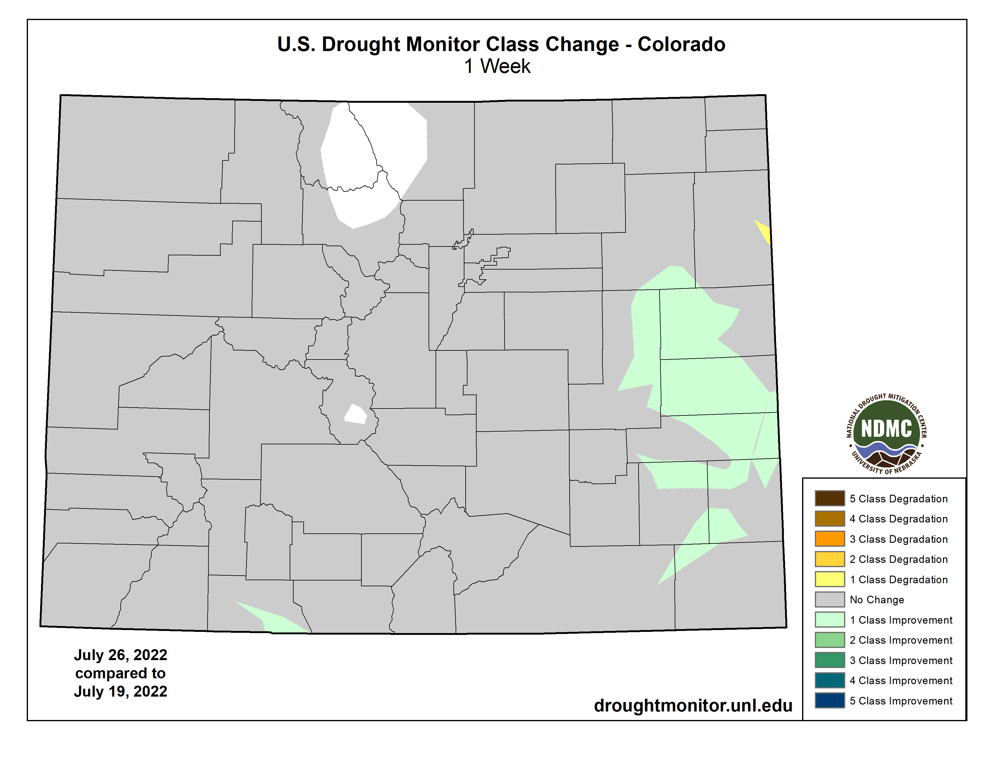
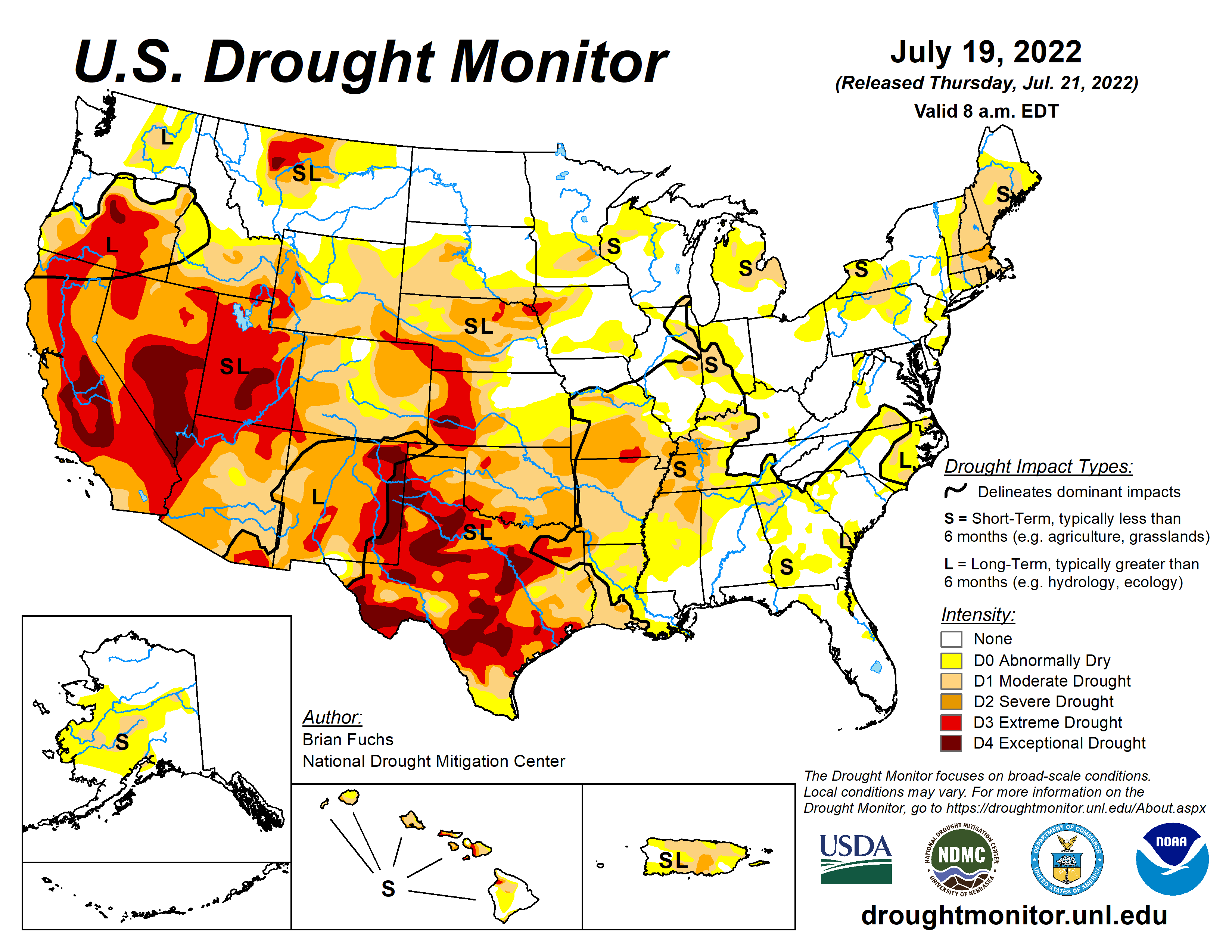
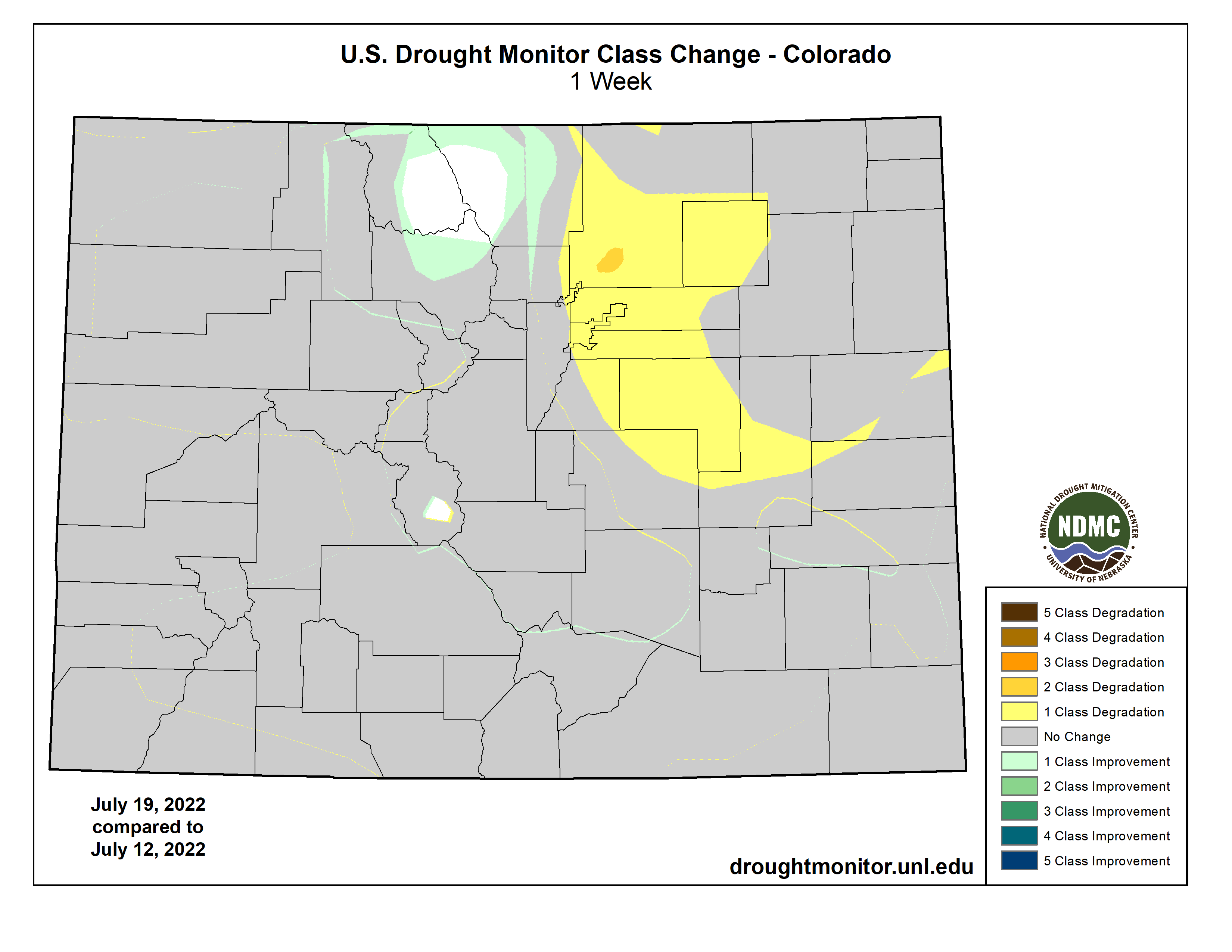
Colorado Drought Monitor map July 26, 2022.
The National Oceanic and Atmospheric Administration (NOAA) National Integrated Drought Information System (NIDIS) reports that 100 percent of the county is experiencing drought.
Although June 2022 was the second wettest June in 128 years, with 2.48 more inches of precipitation than normal, 2022 to date is the 33rd driest year in the last 128 years, with 2.84 fewer inches of precipitation than normal, according to the NIDIS. The NIDIS places the entire county in a moderate drought…The NIDIS also places 46 percent of the county, primarily the southern and western portions, in a severe drought.
Pagosa Springs Panorama. Photo credit: Gmhatfield via Wikimedia Commons
Click the link to read the article on the Pagosa Springs Sun website (Dorothy Elder). Here’s an excerpt:
The San Juan Water Conservancy District (SJWCD) Board of Directors saw the first draft of an Upper San Juan River Basin water supply and demand analysis at its July 25 meeting.
The analysis, conducted by Lakewood-based consultant Wilson Water Group (WWG), studied the supply and demand through 2050 in the Upper San Juan River Basin and was commissioned by the SJWCD. Presenting the results, Erin Wilson, principal at WWG, noted that the results are still a draft and that its findings could be revised or expanded depending on feedback from the board.
The goals of the analysis were to document “current and potential future demands for water from municipal, agricultural, and environmental and recreational users” in the region, as well as “identify options for meeting any potential shortages in water supply in the future,” Wilson stated. The “unprecedented growth” of the Town of Pagosa Springs and ongoing drought conditions of the San Juan region emphasize the importance of this study, Wilson explained…
These demands showed an average annual future shortage that ranges from around 4,100 acre-feet to 73,000 acre-feet in the analysis. Wilson clarified that the shortages incorporate the area’s current water storage capabilities. From these numbers, the analysis suggests potential Dry Gulch reservoir sizes that could meet the needs of the demand projections. The limiting factors in reservoir sizing are the legally and physically available water to fill the reservoir, the 50 cubic feet per second (cfs) filling constraint, and the demands driving reservoir releases, the analysis explains. The 50 cfs limit is based on the Dry Gulch Reservoir water right, and the Dry Gulch environmental flow stipulations have to be met when the reservoir is filling, Wilson explained.
“Note that because the annual high demand shortages are greater than water available for filling (limited by 50 cfs), the reservoir inflow cannot keep up with the reservoir releases; therefore, a reservoir cannot meet the high demand shortages regardless of size,” the report reads.
The recommendations for the reservoir size are 1,600 acre-feet to meet low demand and 10,000 acre- feet to meet mid-range demand. Wilson clarified these calculations are usable volume numbers, not the total volume of the reservoir. The report also offers alternatives to the construction of a reservoir that could potentially lessen shortages and meet demand projections. These include stream restoration, agricultural fallowing and improved forest health…Many of these potential solutions are experimental at this point, and the report suggests that SJWCD “continue to monitor on-going projects to see how the results could be applicable in the Upper San Juan basin.”
Overall, board members brought forward many suggestions to strengthen the report. This included a deeper analysis of wildfire resiliency, leaking issues with PAWSD and a more in-depth look at the need for a reservoir.
There was also a dispute over the 226 gallons per capita per day metric, which board member Joe Tedder thought sounded too high based on Colorado averages.
Wilson clarified the number is the region’s entire demand — commercial included — and not just household use.
Coyote Gulch’s rented Tesla Model 3 charging (Level 2) at Gulch Manor July 30, 2022.
I’ve started a bucket list of places I want to visit before climate change forever changes them. First up are the Sequoias in California. One article that I read recently said that 25% of them have burned since 2015 and last year wildfire threatened some of the most famous trees in the Sequoia and King’s Canyon National Parks (where I’m headed).
Like many Westerners, giant sequoias came recently from farther east. Of course, “recent” is a relative term. “You’re talking millions of years (ago),” William Libby said. The retired University of California, Berkeley, plant geneticist has been studying the West Coast’s towering trees for more than half a century. Needing cooler, wetter climates, the tree species arrived at their current locations some 4,500 years ago — about two generations. “They left behind all kinds of Eastern species that did not make it with them, and encountered all kinds of new things in their environment,” Libby said. Today, sequoias grow on the slopes of California’s Sierra Nevada.
For the drive I was able to rent a Tesla so I’ll be leaving zero emissions along the road except when I charge with dirty power of course.
Posting may be intermittent due to the possibility that I’ll be having too much fun.
The General Sherman sequoia tree is wrapped in fire-resistant foil to protect it from the KNP Complex fire. (National Park Service)
Firefighter Lindsay Freitag sprays down a giant sequoia along the Trail of 100 Giants to extinguish heat.(Garrett Dickman / National Park Service)
Wildland firefighters apply structure wrap to the base of a giant sequoia tree to protect it from the KNP Complex Wildfire, September 17, 2021. Photo credit: Inciweb.org
Like many Westerners, giant sequoias came recently from farther east. Of course, “recent” is a relative term. “You’re talking millions of years (ago),” William Libby said. The retired University of California, Berkeley, plant geneticist has been studying the West Coast’s towering trees for more than half a century. Needing cooler, wetter climates, the tree species arrived at their current locations some 4,500 years ago — about two generations. “They left behind all kinds of Eastern species that did not make it with them, and encountered all kinds of new things in their environment,” Libby said. Today, sequoias grow on the slopes of California’s Sierra Nevada.
Albuquerque, New Mexico — In late June, the mornings start out at 80 degrees but temperatures quickly soar past 100. Everywhere fields are brown and the high desert bakes in glaring sunlight. But there is one long, narrow corridor of green here: the Rio Grande.
Jason Casuga, CEO of the Middle Rio Grande Water Conservancy District, and Anne Marken, water operations manager, have been watching the river’s water gauges around the clock for days, knowing that entire stream segments below Albuquerque may go dry at any time. If rains come over the weekend, everyone will relax, at least for a while.
Side channels were excavated by the Bureau of Reclamation along the Rio Grande where it passes through the Rhodes’ property to provide habitat for the endangered silvery minnow. (Dustin Armstrong/U.S. Bureau Of Reclamation)
If that moisture doesn’t come, Casuga and Marken must move quickly to release to these dry stream segments whatever meager water they can squeeze from their drought-strapped system, giving the U.S. Bureau of Reclamation time to save as many endangered silvery minnow as they can from almost certain death.
“We only have so much time to start the drying operation,” Casuga said, referring to a practice where his district shifts water in its system so that Reclamation can rescue the fish before the stream goes completely dry and leaves them stranded to suffocate.
The Rio Grande Basin spans Colorado, New Mexico and Texas. Credit: Chas Chamberlin
“If we don’t do it, you might see 30 miles of the entire river go dry. It’s stressful. We’ve been doing this controlled hopscotching for weeks now.”
The Middle Rio Grande district, created in 1925, is responsible for delivering waters to farmers as well as helping the state meet its obligations to deliver water to Texas under the 1938 Rio Grande Compact. It coordinates management activity with Reclamation and the U.S. Army Corps of engineers on a river system that includes five major reservoirs and hundreds of miles of canals.
A crippled river
The district’s liquid juggling act is becoming increasingly common, and it is painful for everyone to watch, from the 19 tribes and six pueblos whose homes have lined its banks for thousands of years, to the 6 million people and 200,000 acres of irrigated lands that rely on the river across the three-state river basin.
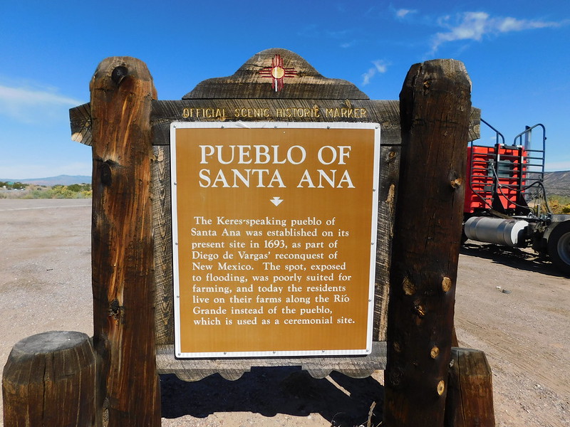
“The worry is heavy,” said Glenn Tenorio, a tribal member of the Santa Ana Pueblo north of Albuquerque, who also serves as the pueblo’s water resources manager.
The Pueblo of Santa Ana lies just north of Albuquerque on the Rio Grande. Credit: Creative Commons
Under the terms of the 1938 Rio Grande Compact, Colorado, New Mexico and Texas share the river’s flows before it reaches Mexico. They have watched drought cripple the river, with flows dropping by 35% over the last 20 years.
But unlike other Western states, in New Mexico water users share both supplies and shortages, and that’s a lesson other states might benefit from, experts say. In most Western states where the prior appropriation system, known as first-in-time, first-in-right exists, water users with younger, more junior water rights are routinely cut off in times of shortage, creating expensive, conflict-ridden water management scenarios.
Water scarcity grows
Still, in response to growing water scarcity, Texas sued New Mexico in 2013, alleging that groundwater pumping in the southern part of New Mexico was harming its own share of water in the river. After being heard briefly before a special master for the U.S. Supreme Court last year, the three states—Colorado is also named in the case—agreed to pause the lawsuit while they conduct mediation talks.
Want more background on the Rio Grande Compact?
Check out this fact sheet
Whether the talks will succeed isn’t clear yet. In addition to the groundwater dispute, New Mexico owes Texas roughly 125,000 acre-feet of surface water from the river and, under the terms of the compact, cannot store any water in its reservoirs until Texas is repaid.
But there is some hope emerging, as Colorado embarks on a $30 million land fallowing program to reduce its Rio Grande water use and as New Mexico seeks new federal rules that will allow it to store more water and re-operate its federal reservoirs.
Abiquiu Reservoir, in northern New Mexico, is one of several that are being drained by the mega drought. Credit: Mitch Tobin, Water Desk, March 2022
Page Pegram helps oversee Rio Grande river issues for New Mexico’s Office of the State Engineer. Unlike Colorado, New Mexico has never had the resources to quantify its various water users’ share of the river. Until now, the state has survived on healthy snowpacks and summer rains.
Though the drought has lasted more than 20 years, in the last five years, Pegram has seen the system deteriorate significantly.
“We’re seeing a fundamental change in water availability,” she said. “Suddenly, everything is different. Temperatures are higher, evaporation is higher, and soil moisture is lower. It’s new enough that we can’t pinpoint exactly what’s happening and we don’t have time to study the issue. It’s already happened.”
The headwaters of the Rio Grande River in Colorado. Photo: Brent Gardner-Smith/Aspen Journalism
In the beginning
The Rio Grande has its genesis in the lush high mountain tundra above Creede, Colo., flowing down through Monte Vista and Alamosa, making its way along Highway 287, crossing the Colorado state line as it flows toward Santa Fe and Albuquerque, then dropping down to the tiny town of Truth and Consequences before it hits the Texas state line. At that point it travels through El Paso and forms the border between Texas and Mexico until it hits the Gulf of Mexico.
It is in the headwaters region in Creede where the majority of its flows originate. And while the hay meadows outside Creede are lush, and the streams cold and full, water has become so scarce even here that if homeowners want to drill a water well, they have to buy water rights from elsewhere to ensure those farther downstream on the river have adequate supplies.
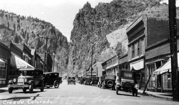
Creede circa 1920
Zeke Ward has lived in Creede for some 40 years, and has served on citizen advisory boards that oversee the river, water quality, and mine residue cleanup efforts.
He said the headwaters area has largely been protected from the most severe aspects of the mega-drought gripping the Rio Grande Basin and much of the American West because there are few people here and 80% of the land is owned by the U.S. Forest Service.
Still, he says, the river is vital to the region’s small tourist economy. “We don’t have a ski area,” he said. “So we have to make a living in 100 days, and that’s not easy.”
Follow the river below Creede and soon you enter the San Luis Valley, where irrigated agriculture dates back at least to the 1500s and where the combination of drought and overpumping have sapped an expansive, delicate series of aquifers. So much water has been lost that the state has issued warnings that it will begin shutting wells down if the aquifer, which is fed from the Rio Grande and its tributaries, is not restored within 10 years.
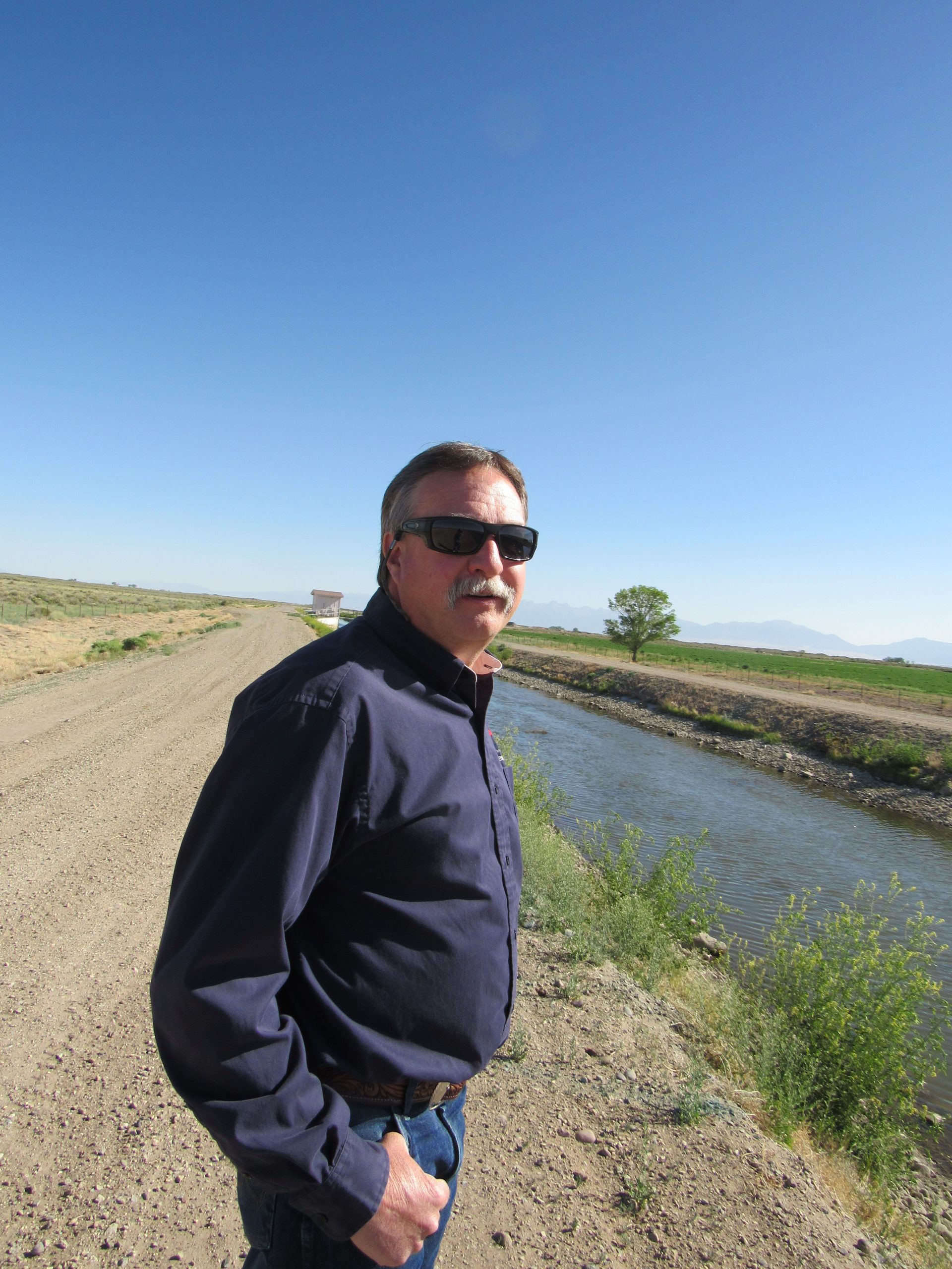
Craig Cotten is the top Colorado regulator on the Rio Grande and has overseen state and community efforts to make sure Colorado can deliver enough water to fulfill its legal obligations to New Mexico and Texas.
Craig Cotten, Colorado’s top regulator on the Rio Grande, stands on a ditch that delivers water to New Mexico to help meet Colorado’s obligations under the Rio Grande Compact of 1938. Credit: Jerd Smith, Fresh Water News
To do so, Cotten routinely cuts water supplies to growers, based on where they fall in the valley’s system of water rights. Right now, Colorado is meeting its compact obligations, but the cost to the valley is high and the cost of failure higher still.
“The farmers are struggling with reaching sustainability,” Cotten said. “If they don’t get there, wells will be shut down.”
But Cotten said he is cautiously optimistic that the Rio Grande can be brought back to health as the climate continues to dry out, in part because there are new tools to manage its lower flows more precisely, including sophisticated airborne measuring systems that show with greater accuracy how much snow has fallen in remote areas and how much water that snow contains.
Knowing more precisely how much water is in the system means the state can capture more when flows are higher, and see more accurately when streamflows will drop. Previously, snow-water estimates have varied widely, miscalculating by as much as 70% or more how much water is in a given mountain region.
In addition, this year Colorado lawmakers approved $30 million to begin a program that will pay San Luis Valley farmers to permanently fallow their lands, something that will relieve stress on the aquifer and the Rio Grande and which could stave off a mass well shutdown.
Plenty to learn
Cleave Simpson manages the Rio Grande Water Conservation District in Alamosa and is also a Colorado state senator.
He believes that the work on the upper Rio Grande holds important lessons for the three states sharing its water and others in the American West.
The people of the Rio Grande Basin have been living with whatever the river can produce for years now, and effectively sharing in any shortages. In addition, though the San Luis Valley aquifers are deteriorating, the farmers in the region have taxed themselves and used some $70 million from those tax revenues to fallow land, something that more and more experts agree will need to be done everywhere, including in the crisis-ridden Colorado River Basin.
“You don’t have very far to look to see your future on the Colorado River,” Simpson said. “Just look at the Rio Grande.”
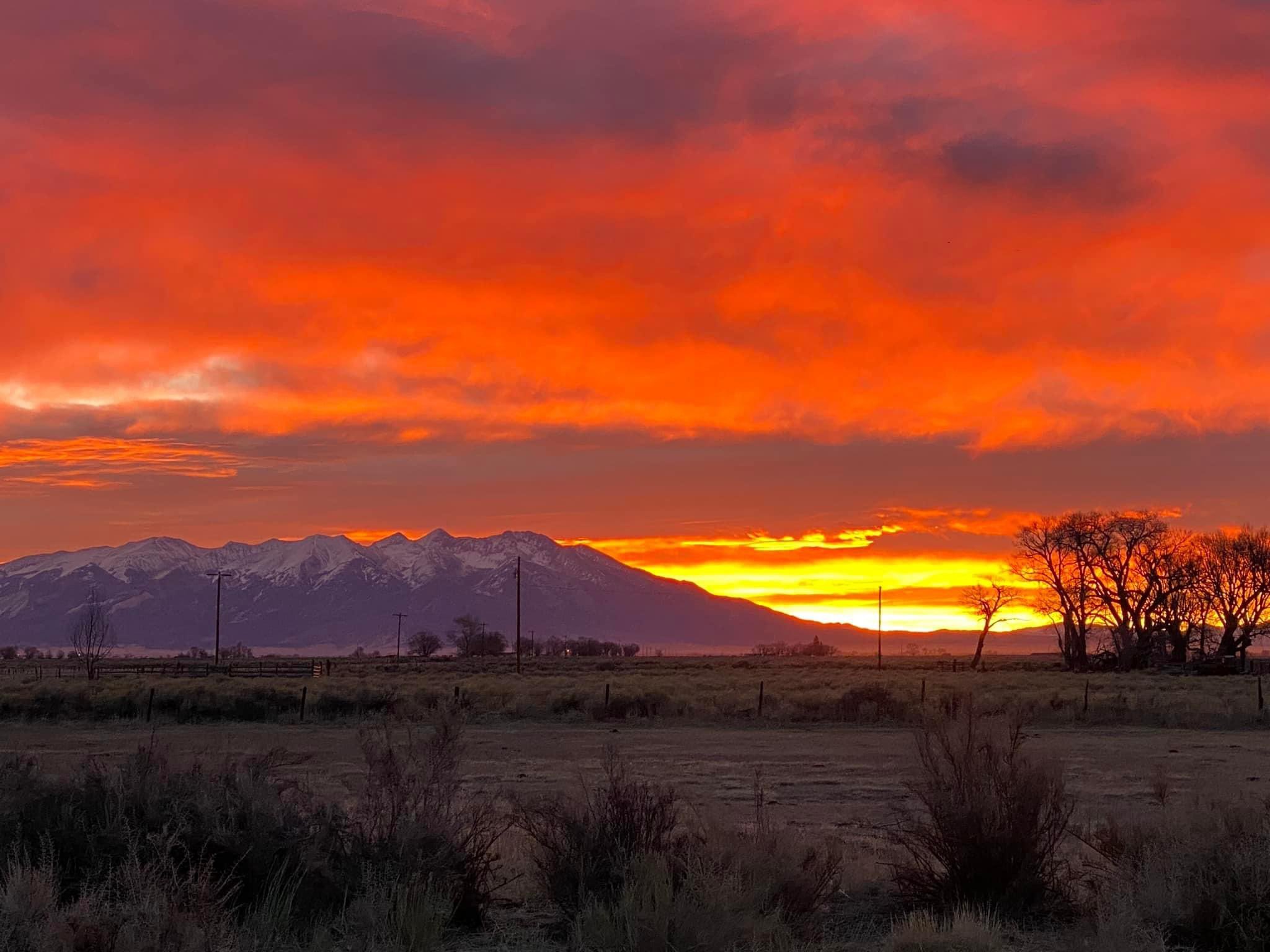
Sunrise March 16, 2022 San Luis Valley with Mount Blanca in the distance. Photo credit: Chris Lopez/Alamosa Citizen
Farmers in the San Luis Valley, including Simpson, are also testing new crops, such as quinoa and industrial hemp, which use less water than potatoes, a longstanding local mainstay.
“I don’t think I can keep doing what our family has been doing for four generations,” Simpson said. “I raise alfalfa because my dad and my grandpa did. But now I am raising 50 acres of industrial hemp for fiber … it certainly uses less water than my alfalfa crop.”
Daily prayers
The work in the San Luis Valley, including the new $30 million paid fallowing program, is a major step toward bringing the Rio Grande Basin back into balance.
And while “fallowing” is a term somewhat new to the water world, it is a management practice some of the oldest users of the river, its tribes, have practiced for millennia.
Tenorio’s family has lived in Santa Ana Pueblo for thousands of years. He said tribal members have learned to balance their needs with whatever the river provides. These days that’s not easy, but he said they focus on the future, to ensure their communities can grow and that their irrigated lands continue to produce the corn, melons, grains, beans and alfalfa that they’ve raised as long as anyone can remember.
“We only can do with what we’re given from Mother Nature,” Tenorio said.
Like other tribes in New Mexico, the Santa Ana Pueblo’s water rights have never been quantified, but because they are so old, they get their water first based on how much is available.
Looking ahead, Tenorio is hopeful that better coordinated use of New Mexico’s few reservoirs, as well as more efficient irrigation systems, will allow everyone to adapt to the drier environment.
“We pray every day for our farmers and everyone who lives on the river,” he said.
Wagon Wheel Gap on the Rio Grande, by Wheeler, D. N. (Dansford Noble), 1841-1909.jpg. Photo credit: Wikipedia
Unlocking manmade infrastructure
Casuga, of the Middle Rio Grande Conservancy District, describes himself as the CEO of bad news. But he said he has some hope that the river can be better managed.
If new rules to operate the federal reservoirs are eventually approved, he says New Mexico could easily meet its water obligations to Texas. An effort is now underway in Washington, D.C., to make that happen.
“This river is highly developed from a human standpoint,” Casuga said. “We as men impact the river so we have to unlock this manmade infrastructure to help it.”
Until then though, the day-to-day reality of operating the river remains complex. In June, when the temperatures were soaring, the rain did come, but it offered only a brief respite for the Rio Grande.
This week, as the searing heat returned, the river began drying out, forcing Casuga and Marken to launch their elaborate hopscotch game again.
Jerd Smith is editor of Fresh Water News. She can be reached at 720-398-6474, via email at jerd@wateredco.org or @jerd_smith.
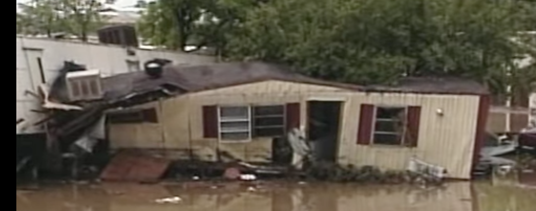
Coyote Gulch’s good friend had just sold his mobile home near Prospect Road and S. College Avenue in Fort Collins when the July 28, 1997 flood hit. The buyers were safe.
Witnesses could hear yells for help, see trailers wash off their foundations and smell the propane that streaked the debris-filled floodwaters…
As July 28, 1997 ended and a new day began, Fort Collins was faced with a new city — one full of twisted debris, totaled cars and forever-changed families.
Twenty years later, walk through the events of that night with this timeline of the Spring Creek Flood. See how heavy rain turned a creek into a deadly river. Watch as a festival-like atmosphere — with people kayaking in the streets — gave way to a somber city the next morning. And revisit the places that were washed away and rebuilt.
How it started — Heavy rainfall pounded parts of Fort Collins, with isolated storms wetting the city on July 27, 1997. The following day, it was about to get worse…
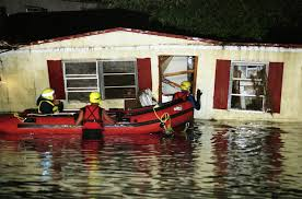
Photo shows rescuers at Coyote Gulch’s good friend’s mobile home near Prospect Road and S. College Avenue in Fort Collins when the July 28, 1997 flood hit. The buyers were safe.
Worries rise with water — What started as heavy rain and minor flooding took a turn as the night of July 28 wore on. With a sprinkling of students, staff and facilities workers on campus at CSU, many witnessed unprecedented damages.
The night turns deadly — “It was a night of terror at a trailer park,” televisions across Colorado boomed as footage from a 9News broadcast showed the hellish landscape along Spring Creek. Fires erupted, trailers washed off their foundations and residents clung to trees as two mobile home parks became targets for the devastation.
July 27, 1997 5 p.m. – After a mostly dry July, torrents of heavy rain begin northwest of Laporte. The storm expands southward into Horsetooth Reservoir.
6:30 p.m. – Heavy rain mostly stops. The air remains humid.
Midnight – Southeasterly winds behind a cold front push more moist air against the eastern foothills.
July 28, 1997
1 a.m. – Steady rain develops, at first limited to a narrow band along the foothills.
2 a.m. – Rainfall rates in excess of 1 inch per hour develop northwest of Laporte. Residents wake up to standing water.
8 a.m. – After early morning letup of overnight rains, a brief, soaking shower catches Fort Collins morning commuters. To the northwest, major flooding begins around Laporte.
Noon – Skies remain cloudy over the Fort Collins area Monday afternoon. Dewpoint temperatures hover in the low 60s.
6 p.m. – A first wave of heavy showers moves into Fort Collins. Rain increases with hourly accumulations of close to 1 inch in southwest Fort Collins.
7 p.m. – Rainfall rates approach 3 inches per hour, according to a rain gauge at the CSU Foothills Campus.
8 p.m. – Flooding of homes and streets in Fort Collins intensifies. The water is 2 feet deep at Elizabeth and Shields streets. Flow rate along Elizabeth is comparable to that of the Poudre River.
8:30 p.m. – Extremely heavy rain falls locally over a few square miles approximately at the corner of Drake Road and Overland Trail. Rainfall totals for a 90-minute period exceed 5 inches. The heaviest-hit area includes the Spring Creek watershed.
9:30 p.m. – The National Weather Service issues a flash flood warning for Larimer County.
10:30 p.m. – Floodwater bursts open the Lory Student Center’s west doors.
11 p.m. – The water level in a nearby mobile home park rises 5 feet in 3 minutes. Five people die. A train derails. A gas leak causes an explosion south of Prospect Road and east of the railroad tracks.
July 30, 1997
Summer classes are back in session on campus.
August 1997
Fall classes at CSU begin on time.
September 1997
A picnic is added to President Al Yates’ annual fall address to thank the campus and community for its resilience in the wake of the disaster. The tradition continues today.
These are perilous times in the troubled Colorado River basin, a make-or-break moment in which some of the nation’s fastest growing and most arid states begin to reckon with a drier future.
The next month will be especially intense.
Several weeks ago, in the face of another paltry runoff forecast, the Bureau of Reclamation issued an ultimatum to the basin’s seven states: to keep key reservoirs Mead and Powell from crashing, develop a plan by mid-August to conserve 2 million to 4 million acre-feet of water in the next year — or the Bureau would make the cuts as it sees fit.
Those are astounding figures. On the higher end, that amount of conservation is one-third of the Colorado’s recent annual flow. It’s also about as much water as California is allocated from the river.
The plan’s due date coincides with the publication of a highly anticipated and consequential Bureau of Reclamation report. The so-called 24-month study — tentatively scheduled for August 15 — determines how much water Mead and Powell will release in 2023. It also determines how much water Arizona, California, Nevada, and Mexico, which shares the basin, will be required to forgo next year.
Discussions about the Colorado River can resemble a doctor’s visit: filled with technical jargon, unfamiliar acronyms, and the anxiety that comes from incomplete understanding.
This glossary is an attempt to demystify the language. It outlines key terms and phrases and their context — so as the basin chatter heats up you can keep your DCP and DROA actions straight and know who’s taking ICS.
Map credit: AGU
Upper/Lower Basin
In terms of law and management, the Colorado River basin is split in two.
The upper basin states are Colorado, New Mexico, Utah, and Wyoming (plus a tiny sliver of Arizona that is essentially Navajo Nation land). The lower basin is Arizona, California, and Nevada. Separate agreements bring Mexico into the mix.
Las Vegas Lake Mead intake schematic, courtesy SNWA.
Dead Pool
All reservoirs have limits. Dead pool, an evocative term, is the ultimate limit. It’s the point at which water can no longer be released downstream because a reservoir falls below its lowest outlet pipe.
For Lake Mead, dead pool is elevation 895 feet. For Powell, 3,370 feet.
Today, the reservoirs are at 1,040 feet and 3,536 feet, both at about 27 percent of full capacity.
Even at dead pool some water might remain in the reservoir, but it can’t flow without extraordinary assistance. Las Vegas, in a proactive step, invested $1.3 billion in an intake pipe and low-elevation pumping station that allow the city to draw water from Mead when the reservoir is at dead pool.
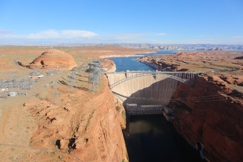
Lake Powell’s Glen Canyon Dam is used to produce hydropower that is delivered over a 17,000-mile transmission grid, reaching six states and 5 million people. Photo courtesy Western Area Power Administration.
Minimum Power Pool
A second limit for a reservoir, minimum power pool refers to the water level required to generate hydropower.
This is the level near the location of the penstocks. Penstocks are the pipes that move water from the reservoir to the power-generating turbines.
For Powell, minimum power pool is 3,490 feet. The Bureau of Reclamation is attempting to prevent Powell from dropping below this level.
For Mead, minimum power pool is 950 feet.
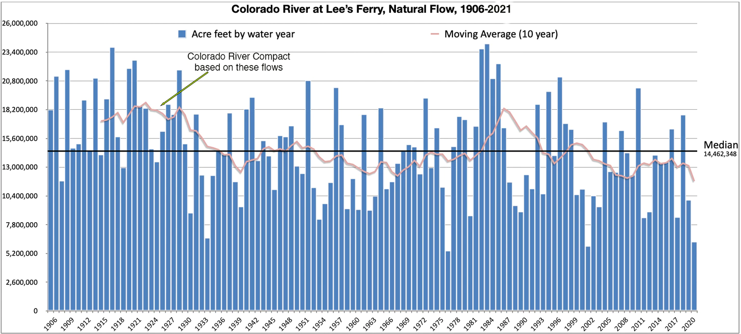
Natural Flow is an estimate of how much water would have naturally run past Lee’s Ferry if there were no dams or diversions upstream. It is calculated using the actual flow, historic flows, and upstream consumptive uses. Bureau of Reclamation modeling is complete to 2019; I extrapolated 2020 and 2021 based on Lake Powell inflows. The 1922 Colorado River Compact gave 7.5 million acre feet to the Upper Basin, 7.5 MAF to the Lower Basin, and (in the ‘40s) 1.5 MAF to Mexico, based on early 1900s observations. As the graph above shows, the average flows dropped below that level a decade later and stayed there aside from a brief respite in the 1980s. Source: USBR
Operational Neutrality
The Bureau of Reclamation took an unprecedented step in May, announcing that it would reduce releases from Powell to Mead this year by 480,000 acre-feet.
The move helped keep Powell above minimum power pool. But it came with a worrisome side effect for the lower basin states: less water sent downstream to Mead.
They have good reason to worry. Depriving Mead of that water meant a greater likelihood of a more severe shortage tier for the lower basin next year. Mead, in fact, has plummeted this year, falling 21 feet since April.
The states and the feds agreed to a work-around. To maintain “operational neutrality” the shortage tiers for next year would be calculated as if the 480,000 acre-feet had been released to Mead. In other words, on paper the water is in Mead…but in reality it sits upstream in Powell.
Every bit of water matters these days. Currently one foot of elevation change in Mead is equal to about 70,000 acre-feet. So the 480,000 acre-feet held back in Powell corresponds to roughly 6.8 feet in Mead.
How long will this shadow accounting be in place? Becki Bryant, a Reclamation spokesperson, told Circle of Blue that the agency is discussing that matter with the states. They hope to reach an agreement by the publication of the August 24-month study.
24-Month Study
The name explains its purpose. Published every month, this Bureau of Reclamation study projects reservoir elevations in the Colorado River basin for following 24 months.
The pivotal edition is the August study, which sets the operating conditions for the reservoirs for the next year. Here’s how it works:
Reclamation looks at the projected elevations of Mead and Powell at the beginning of the upcoming year. Their elevations determine how much water flows from Powell to Mead. There are complex charts that describe the scenarios and dictate the decision.
In turn, Mead’s elevation determines if the lower basin states are in a shortage tier, which requires water supply cuts from the river.
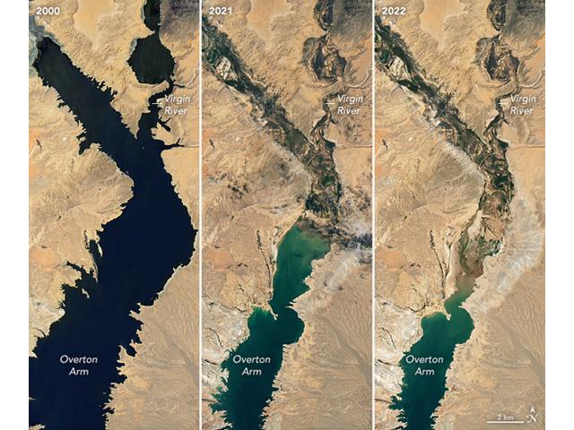
Images from the NASA Earth Observatory released in early July focused on the northern arm of Lake Mead and its decline from 2000 until now. As western states are being asked for solutions to keep Lake Mead and Lake Powell from hitting critical low points, there is more talk about what it would take to pump water from the Mississippi River to western states as well. (Image courtesy of NASA Earth Observatory)
Shortage Tiers
When Mead drops below certain elevations, the lower basin states and Mexico must reduce their withdrawals from the river.
The shortage tiers have evolved as the basin’s water supply imbalance has become more pronounced.
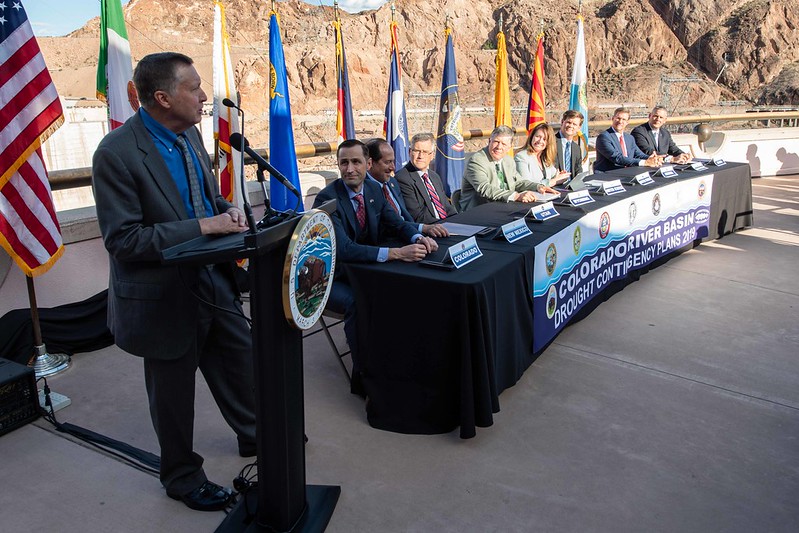
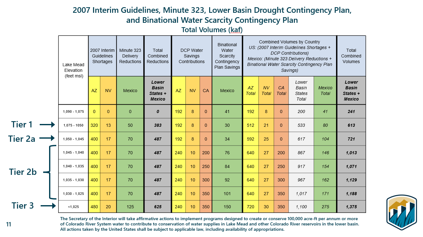
The initial tiers were set in 2007, in what are known as the interim guidelines. The tiers were updated in 2019 in the DCP. What’s that, you ask?
Colorado River drought contingency plans signing ceremony in May 2019. Photo: U.S. Bureau of Reclamation
DCP
Short for drought contingency plan, the DCP was approved by the basin states and the federal government in 2019.
The DCP updated the shortage tiers by increasing the amount of water cuts that lower basin states would take as Mead drops. For the first time, California agreed to take cuts, but not until Mead drops below 1,045.
In 2022, the lower basin is in a Tier 1 shortage. Arizona is taking most of the cuts.
What about the upper basin? Those states signed DROA…
Lees Ferry, located 15 miles downstream of Glen Canyon Dam is the dividing line between the upper and lower Colorado River basins. Photo/Allen Best
DROA
Short for drought response operations agreement, this is the upper basin’s portion of the DCP. It outlines actions that the upper basin will take to preserve water levels in Powell.
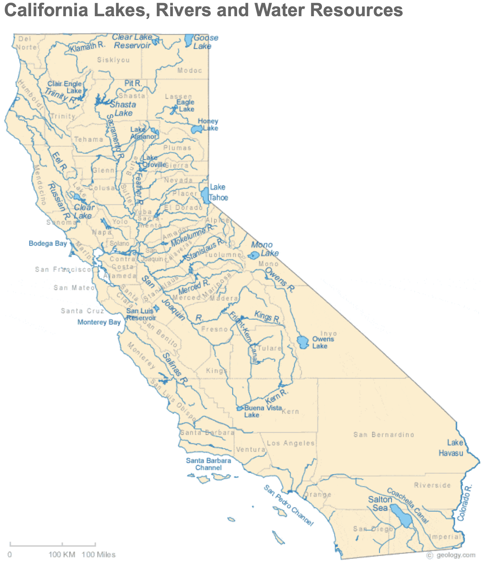
Arizona Rivers Map via Geology.com.
Shortage Tier 2A
One of two possible shortage tiers for 2023. This tier occurs when the August 24-month study projects that Mead will be between 1,050 feet and 1,045 feet on January 1 of the following year.
Mead is on the cusp right now. Alan Butler, a Reclamation hydraulic engineer, said on July 13 that Mead is projected to be at elevation 1,045.9 feet in January, after accounting for operational neutrality.
If a 2A tier is declared, Arizona continues to take the largest cut. It would forgo 592,000 acre-feet, about four-fifths of the total cuts shared by the lower basin and Mexico.
California Rivers via Geology.com
Shortage Tier 2B
This is the other possible outcome, which would take place if Mead is projected to be between 1,045 feet and 1,040 feet.
In this tier, California takes its first shortage cuts. Though Arizona, having to cut 640,000 acre-feet, would still feel the most pain, California would be required to cut 200,000 acre-feet.
These shortage tier numbers do not include Reclamation’s mandate for 2 million to 4 million acre-feet of additional savings, nor do they include the 500-plus plan.
Aerial photo – Central Arizona Project. The Central Arizona Project is a massive infrastructural project that conveys water from the Colorado River to central and southern Arizona, and is central to many of the innovative partnerships and exchanges that the Gila River Indian Community has set up. Public Domain, https://commons.wikimedia.org/w/index.php?curid=326265
500-Plus Plan
An agreement from lower basin states to conserve an additional 500,000 acre-feet in 2022 and 2023 beyond what was required in the Tier 1 shortage declaration for 2022. The states and federal government contributed $200 million combined, money that will pay water users to leave their allocations in Mead.
Brad Udall: Here’s the latest version of my 4-Panel plot thru Water Year (Oct-Sep) of 2021 of the Colorado River big reservoirs, natural flows, precipitation, and temperature. Data (PRISM) goes back or 1906 (or 1935 for reservoirs.) This updates previous work with @GreatLakesPeck.
Protection Volumes
When Reclamation ordered the basin states to plan for 2 million to 4 million acre-feet in additional conservation, Camille Touton, the agency’s leader, said it was to protect “critical levels” in Mead and Powell.
What are those critical levels? Reclamation analyzed two scenarios. But the conservation mandate was derived from the scenario that keeps more water in the reservoirs.
That scenario is Mead above 1,020 feet and Powell above 3,525 feet. The “protection volumes” are the 2 million to 4 million acre-feet needed to preserve the reservoirs above those thresholds.
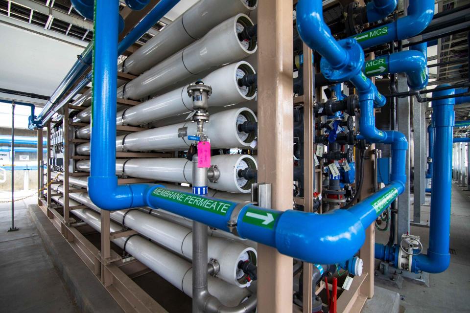
Filtration pipes at Metropolitan Water District of Southern California’s wastewater recycling demonstration plant. (Source: Metropolitan Water District of Southern California)
ICS
An acronym that stands for intentionally created surplus, which acts like a savings account in Mead.
Lower basin water users can accrue ICS when they undertake conservation projects that permanently reduce consumption. Combined, the lower basin states have just accumulated shy of 3 million acre-feet of ICS credits stored in Mead.
Some of that water will be drawn this year. Metropolitan Water District of Southern California, a large wholesale agency, anticipates taking 175,000 acre-feet of ICS, according to spokesperson Bob Muir. This is to offset reduced allocations from the State Water Project, a canal system that moves water from north to south in California.
In response to continued forecast precipitation, the Bureau of Reclamation has scheduled a decrease in the release from Navajo Dam from 500 cubic feet per second (cfs) to 400 cfs for today, July 28th, at 4:00 PM.
Releases are made for the authorized purposes of the Navajo Unit, and to attempt to maintain a target base flow through the endangered fish critical habitat reach of the San Juan River (Farmington to Lake Powell). The San Juan River Basin Recovery Implementation Program recommends a target base flow of between 500 cfs and 1,000 cfs through the critical habitat area. The target base flow is calculated as the weekly average of gaged flows throughout the critical habitat area from Farmington to Lake Powell.
Water connects us and supports the lives of every bird and Coloradan every day. It’s time for action for Colorado’s birds and people. People tend to evade challenging work in water until a crisis. Now is an opportune time to lean in and work for holistic water solutions that sustain a more water-resilient Colorado to support our birds, fish, other wildlife, rivers, and all people—equally.
Ironically, water stress can bring hope. [ed. emphasis mine] Pressure can sharpen focus towards innovative actions to protect what is precious to us. The draft Colorado Water Plan update is an opportunity to engage in our sustainable water future—for all of us. After intense work by Colorado Water Conservation Board (CWCB) staff and directors, the draft plan made a public debut on June 30th and is open for comment through September 30th. The plan will be finalized in January 2023 and direct Colorado’s water priorities for ten years.
Coloradans shape our water planning and management. A diversity of voices, needs, and knowledge must be integrated into this water plan update process. Our solutions are stronger with diversity and collaboration. Understanding how, when, and where to engage in water is essential. In 2015, Audubon contributed thousands of public comments and technical input to the completion of the inaugural water plan. We will again call on you, the broad Colorado Audubon network, to engage in this critical water plan update. In the coming weeks, help us define this moment for birds, rivers, and people.
The updated water plan calls on Coloradans to actively contribute to our water-resilient future through participating in any of the approximately 50 identified partner actions. Colorado is a local control state. So, local participation is critical to the health of Colorado’s local river systems and economies. The updated plan also details 50 actions that state agencies will take to help advance local water projects and initiatives.
The plan update also reflects the very real and everyday impacts of climate change—like aridity, wildfires, and floods—on Colorado’s water resources. Over the majority of the last ten years, Colorado has been racking up superlatives like “hottest,” “driest,” and sadly, more than one “historical wildfire” title.
Audubon encourages our membership to track down where your water comes from, commit to an expanded water stewardship ethic (see Water ’22 or Habitat Hero for ideas), and read about your basin as well as chapter six in the draft updated water plan.
Here are some top highlights from our review focused on the “Thriving Watersheds” and “Resilient Planning” sections of the draft plan.
Top Three Likes
Resiliency is a core pillar in the draft plan. We all depend on watersheds and natural systems for delivery and eco-services to access reliable, clean water. Wildlife and people must be able to respond to what nature gives us. Birds, other wildlife, and all people must be able to respond to and sustain themselves in both scarcity and abundance of water—this is the core of resilience to climate change shocks.
The draft plan acknowledges the need for and inclusion of river health assessment frameworks, a stream construction guide, nature-based solutions, green infrastructure strategies and techniques, and water-dependent native species data coordination and access. Resilience requires a baseline understanding of our watershed and river systems to support sustainable and positive management. Rivers and river health are a crucial part of how we meet our water challenges in Colorado. We need to understand river health conditions more and easily access data to manage and restore this invaluable resource nimbly. Audubon thanks the CWCB staff for the many meetings discussing the importance and inclusion of these topics.
The draft plan also begins down the path of how to engage everyone working towards equity, diversity, and inclusivity in the Colorado water space. The decisions we make about water impact everyone. A diversity of voices representing a diversity of needs strengthens Colorado’s water decisions. The draft update contains leaps forward from the 2015 plan with more substantive diversity content regarding the inclusion of the Water Equity Task Force principles. This includes translating the entire plan and factsheets into Spanish for better language equity, and broader inclusion of the Ute Mountain Ute and Southern Ute Indian tribes in the plan’s vision and actions. The advancements in the water equity, diversity, and inclusivity space are notable, while considerable work in actualizing this critical work must still follow. “Connectivity must begin with identifying those most vulnerable around us, building their capacity to engage, and assuring that their needs are prioritized. A region, after all, is only as strong as its most vulnerable communities,” notes the 2020 California Water Resilience Portfolio.
Top Three Needs
Coloradans know we need to act on behalf of water resilience and act quickly. There is an urgency to start implementing water security solutions at scale and take advantage of once-in-a-generation federal funding. Although the draft plan sets an ambitious scope of activity and vision, how will we track work in a transparent and publically accessible way? What are the timelines for achieving this critical work?
The need for more traditional storage is mentioned numerous times in the draft plan. Colorado’s current reservoirs are often far below their capacities. Building more dams to hold questionable water supply is not a sustainable solution to the water crisis. Instead, we need balanced strategies for innovative storage opportunities looking at forest health, pre-wildfire watershed readiness, and creativity to complement storage with nature-based solutions like wet-meadow and wetland restoration. These strategies increase wildlife habitat, improve water quality and cycling, lift wildfire preparedness and recovery, increase overall river health, and provide recreational opportunities for local communities and economies.
River health is a key component of Colorado’s water resilience. In the draft plan, there is a high priority on watershed-scale work and less on the scale of streams and rivers. The plan needs to include more weight on statewide river health, as Colorado’s river-related recreation is a major economic driver for the state, with more than $10 billion spent each year and nearly $19 billion in overall economic output. Birds, recreation, and agriculture all depend on healthy rivers flowing from resilient watersheds. All of us rely on healthy river ecosystems to thrive.
Colorado’s future depends on water and each of us—birds and people—is connected by it. Even if you are not a water right holder, we are all responsible for engaging in the Colorado Water Plan update and contributing to the stewardship of our water resources. When we understand the connections—where our water comes from and how much we depend upon it—we value water for what it is: life and sustainability for people and nature. Watch for guided water plan engagement opportunities from Audubon. Kingfishers, American Dippers, Snowy Egrets, and Colorado’s water-resilient future depend on you to lean in and participate. Thank you in advance for your engagement in the update of the Colorado Water Plan.
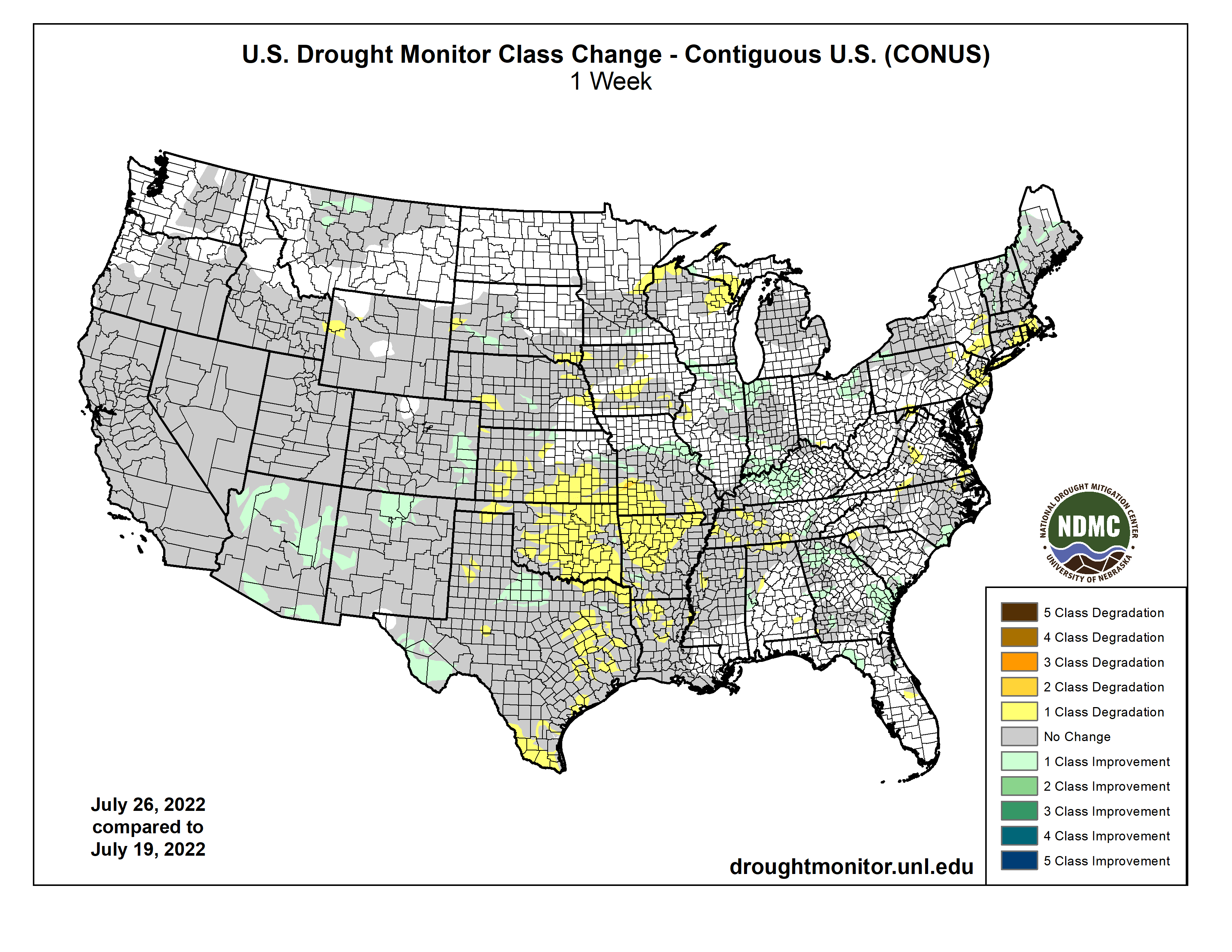
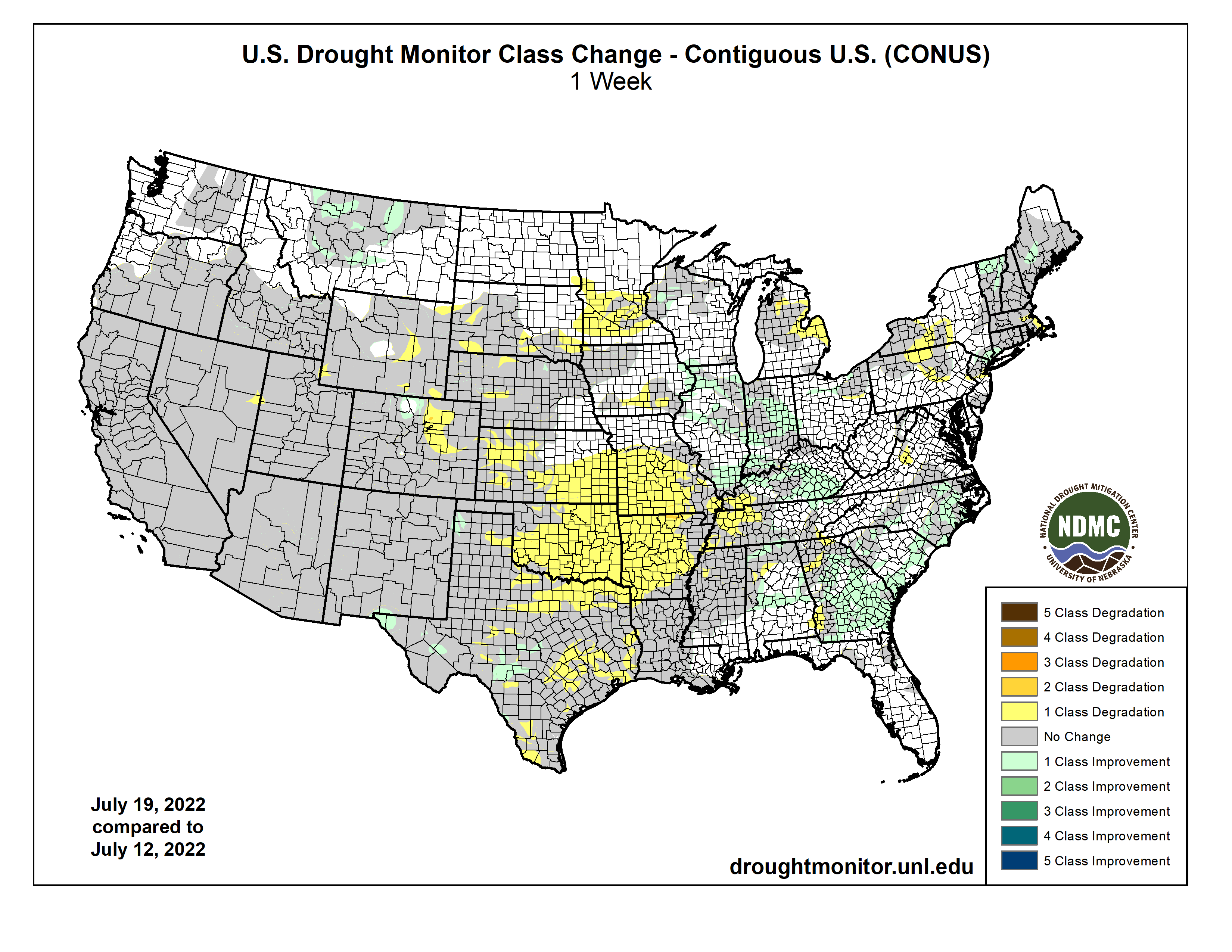
Drought persisted across much of the West this week, while flash drought over parts of the Great Plains, Ozarks, and Mississippi Valley continued to intensify and cause agricultural problems. Short-term drought also expanded over parts of the Northeast this week, where deficits in short-term precipitation and streamflows mounted in some areas. Conditions locally improved in parts of the Southwest due to an influx of rainfall from the North American Monsoon. Farther east into the lower Great Plains and Midwest, localized heavy rainfall led to improvements, including severe flooding in the St. Louis Metro area, which previously had been experiencing abnormally dry conditions. In Alaska, moderate drought was mostly removed after recent rainfall improved conditions there…
With the exception of Colorado (which was mostly warmer than normal) and southern Kansas (which was 4-8 degrees warmer than normal), temperatures in the High Plains region this week were generally within 2-4 degrees of normal. Rainfall from the North American Monsoon occurred in parts of southern, central, and eastern Colorado, locally easing drought conditions in the eastern part of the state. Heavy rains in south-central and southwest South Dakota, and in southern Nebraska, northern Kansas, and east-central Kansas, led to locally improved drought and dryness conditions. Meanwhile, south of the heavier rains, flash drought continued to take hold in southern Kansas, where a combination of dry and hot weather worsened conditions. Extreme drought expanded in parts of southwest Nebraska, where short- and long-term precipitation deficits worsened conditions amid poor crop health. Drought also expanded in northeast Nebraska and southeast South Dakota, where soil moisture deficits continued to mount amid warm temperatures and dry weather. Extreme drought also developed in western Wyoming, where above-normal evaporative demand combined with short-term precipitation deficits to worsen conditions locally…
Colorado Drought Monitor one week change map ending July 26, 2022.
Rainfall from the North American Monsoon over the last few weeks led to some improvements in the drought situation across Arizona and New Mexico, where precipitation deficits lessened. Rain also fell in parts of Nevada, Utah, and eastern California this week. Temperatures were mostly 2-6 degrees above normal in the West region, though scattered areas were within a couple degrees of normal. Precipitation deficit amounts lessened enough for some improvement to ongoing short- and long-term drought in central Montana. Elsewhere, widespread drought continued this week across a large portion of the region…
Weather across the South this week was mostly hot and dry, with some notable exceptions. Heavier rain occurred in southern Louisiana and southern Mississippi, as well as eastern Tennessee. Very localized heavy rain fell from east-central Oklahoma into southwest Arkansas. Temperatures across the region were generally 2-8 degrees warmer than normal, with the warmest readings occurring in Oklahoma, Texas, northern Arkansas, and the western half of Tennessee. Flash drought conditions intensified further in central and northern Arkansas, central and eastern Oklahoma, and in spots in western Tennessee, northern Mississippi, northern Louisiana, and eastern and southern Texas. Crop failure and related problems are widespread in the part of the region experiencing flash drought, especially in northeast Texas, eastern and central Oklahoma, and northern Arkansas…
Looking Ahead
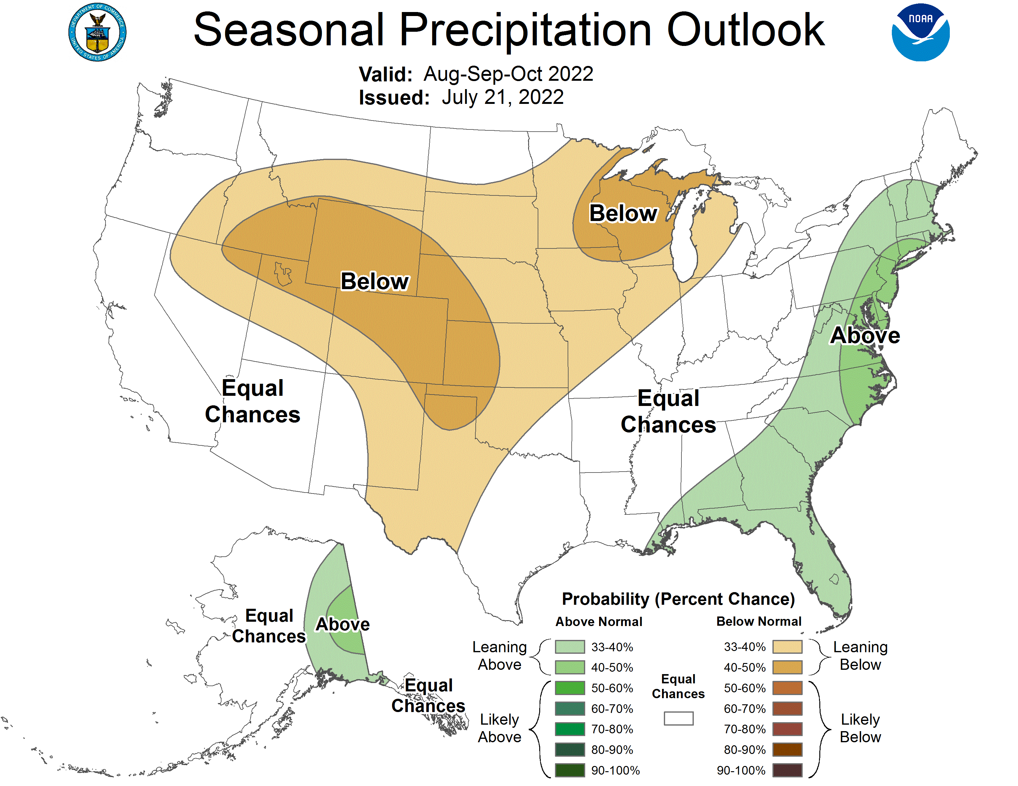
Through the morning of Tuesday, August 2, the National Weather Service Weather Prediction Center is forecasting heavy rainfall to occur from northern New Mexico and southern Colorado eastward across parts of the southern Great Plains, Mid-South, and southern Appalachians, including some areas currently experiencing flash drought. Pockets of heavy rain also may occur in western New Mexico and portions of Arizona. Elsewhere, rainfall is forecast to remain generally spotty, with many areas staying dry or mostly dry. During this period, hot weather is forecast in the Northwest, while hot temperatures are forecast over the northern Great Plains and cooler-than-normal weather is likely in the central Great Plains during the weekend (July 30-31). Temperatures are forecast to return to near-normal levels in these areas, and then may begin to warm as Tuesday, August 2 approaches.
For the period of August 2-6, the National Weather Service Climate Prediction Center forecast strongly favors warmer than normal temperatures over the eastern two-thirds of the contiguous United States, especially in the Middle Missouri River Valley. Below normal precipitation is favored in the central Great Plains, and to a lesser extent is also favored in parts of the Midwest and eastern Great Lakes. Above normal precipitation and below normal temperatures are favored in much of the western United States. Above normal precipitation is favored in east-central Alaska, while southwest Alaska is likelier to see below normal precipitation. Most of Alaska, excepting the far northern areas, is likelier to see below normal temperatures.
US Drought Monitor one week change map ending July 26, 2022.
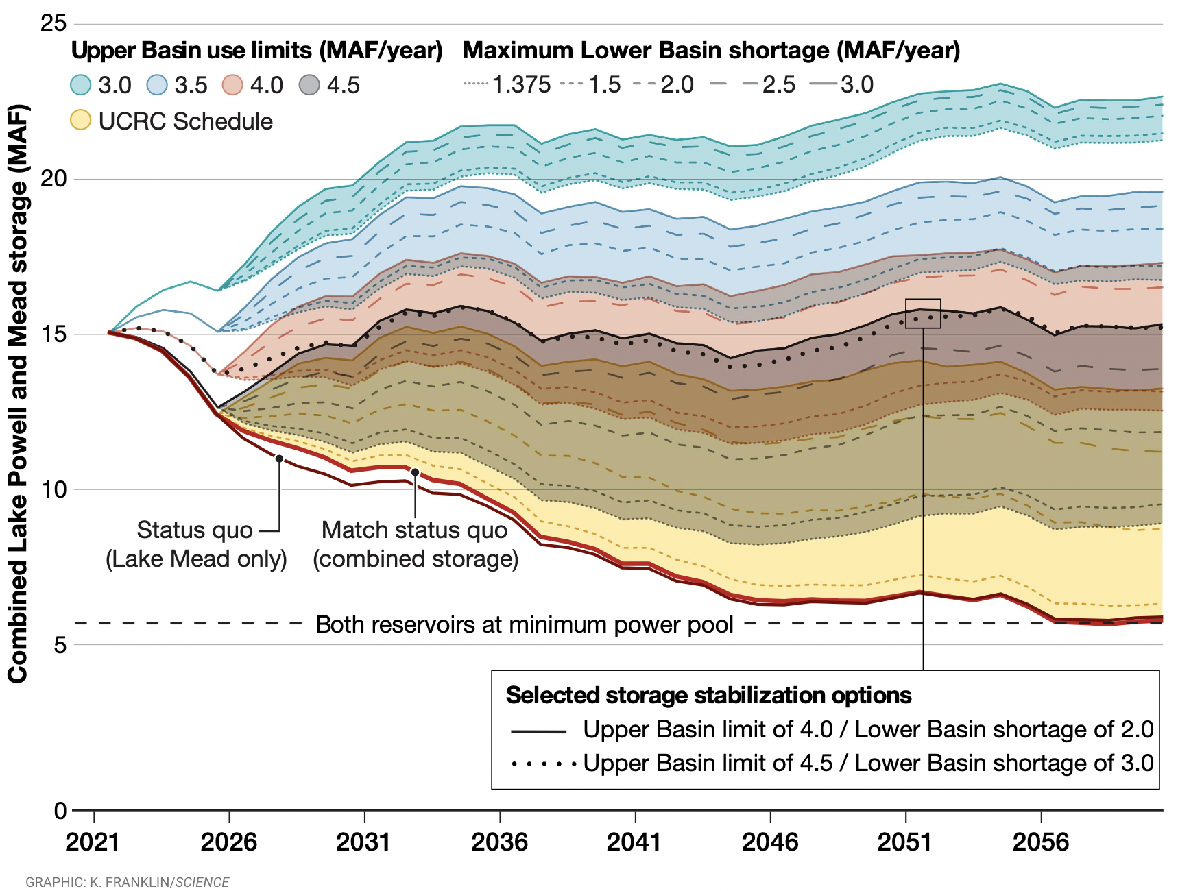
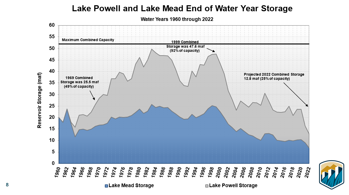
Average end-of-year combined Lake Powell and Lake Mead storage is shown, assuming hydrologic conditions of the Millennium Drought continue. Results show combined reservoir contents using a range of Upper Basin consumptive use limits (colored ribbons) along with a range of Lower Basin maximum consumptive use reductions (line styles) triggered when the combined storage falls below 15 million acre-feet (MAF). The status quo lines use the 2016 Upper Colorado River Commission (UCRC) projections and existing elevation-based shortage triggers. All water use and shortage values are annual volumes (MAF/year).
The Colorado River is in trouble—Lakes Powell and Mead, the two major reservoirs fed by the river, reached record lows this year nearing 25% capacity. An ongoing megadrought, impacts from climate change and systematic overuse have created a deep management crisis. Although there is growing public acknowledgement that cuts in consumptive use are inevitable and policy changes are needed, renegotiation of the rules governing this critical shared river are fraught with complexity and impeded by competing priorities between states.
In a new policy forum commentary in the journal Science (Free Access Link) researchers from the Center for Colorado River Studies describe the political history leading up to the current management crisis and present results from innovative research to offer perspective on what is needed to stabilize or reverse the decline of reservoir storage. Using adaptations to the Colorado River Simulation System, the researchers quantify the magnitude of consumptive use cuts necessary to balance the system, maintain power generation and secure water supplies if the current drought persists.
The new commentary identifies combinations of Upper Basin consumptive use limitations and Lower Basin reductions necessary to stabilize reservoir storage levels. If Upper Basin water use remains at current levels or increases (i.e., 4.0 to 4.5 million acre-feet per year), then water use in the Lower Basin must be reduced immediately by 2.0 to 3.0 million acre-feet per year to even maintain the combined Powell and Mead storage at their current depleted levels. Not achieving these critical objectives will lead to further decline of system storage, and these commitments must be sustained, the authors said.
There are many possible ways to reduce use, said the authors. A continuation of the current 23-year-long drought will require difficult management decisions in any event. Implementing, or even accelerating, the policy changes necessary to stabilize the Colorado River system requires well-grounded insight to project the impacts of those policies on the system. The reservoirs can be stabilized under specific runoff conditions, but a critical change needed is triggering reductions in use based on the combined storage of Lake Mead and Lake Powell, said Kevin Wheeler, lead author on the commentary.
The research shows that current policies can’t stabilize the Colorado River if the drought continues, however there are various consumptive use strategies that could—if these strategies are applied swiftly. Although the proposed limits and reductions in consumptive use being considered may seem like a political impossibility at present, they will become inevitable if hydrologic conditions persist, said Wheeler [ed. emphasis mine].
Brad Udall: Here’s the latest version of my 4-Panel plot thru Water Year (Oct-Sep) of 2021 of the Colorado River big reservoirs, natural flows, precipitation, and temperature. Data (PRISM) goes back or 1906 (or 1935 for reservoirs.) This updates previous work with @GreatLakesPeck.
In response to continued forecast precipitation, the Bureau of Reclamation has scheduled a decrease in the release from Navajo Dam from 600 cubic feet per second (cfs) to 500 cfs for today, July 27th, at 4:00 PM.
Releases are made for the authorized purposes of the Navajo Unit, and to attempt to maintain a target base flow through the endangered fish critical habitat reach of the San Juan River (Farmington to Lake Powell). The San Juan River Basin Recovery Implementation Program recommends a target base flow of between 500 cfs and 1,000 cfs through the critical habitat area. The target base flow is calculated as the weekly average of gaged flows throughout the critical habitat area from Farmington to Lake Powell.
This graphic shows the increasing warming influence over time of CO2 and non-CO2 greenhouse gases, in CO2 equivalents, on the left axis. The corresponding increase in the AGGI is shown on the right axis. Credit: NOAA Global Monitoring Laboratory.
According to studies from The Colorado Health Institute and others, our state’s median temperature increased by two degrees Fahrenheit, in just the past 30 years. In response, the Institute enacted “Think globally, Act locally” – a new project that examines climate changes, the impact on Coloradans’ health, and whether the state is prepared to address those health impacts.
Khira Isaacs spoke with officials from the “C-H-I” about a new tool designed to help protect our health — and prevent Colorado from reaching its boiling point.
“We’ve worked on CHI’s Climate and Health portfolio for the better part of the last half decade really making sense of the connection of climate’s impact on the health of Coloradans,” says Senior Policy Analyst, Karam Ahmad.
Ahmad also says climate change can increase the risk of injury, illness and disease, or death. But not all communities or individuals are affected in the same ways — unique circumstances and characteristics all play a role. Currently, Mesa County and other Western Colorado counties rank highest on the list: the five deciding factors being number of extreme heat days, percentage of land with highest wildfire risk, percentage of weeks population experiences drought, percentage of the population who lives in a wildland urban interface and community flooding.
“And when we look at the map right here, looking at our overall risk. We are seeing southern Colorado and southeast Colorado really highlight some of the highest risk. And the reason we are seeing these counties in the category — a lot of it has to do with they have some of the highest rates of poverty in the state. We also saw that they have some of the oldest homes -When it’s very hot out or when there’s poor air quality, our house is where we seek shelter and so an older home is less likely to have insulation or upkept with maintenance and those are very important things when it comes to air quality and the heat,” says Policy Analyst, Chrissy Esposito.
The Health and Climate Index is part of “Acclimate Colorado” — Colorado’s Health Institute’s effort to build capacity, community resilience and an agenda for addressing climate-related health challenges. The tool gives professionals a road map to confront and adapt to environmental and public health threats — it’s a conversation Ahmad says should happen frequently.
Photo of the Lower Yellowstone Fish Passage Project via USBR.
Click the link to read the release on the Reclamation website (Brittany Jones):
The Bureau of Reclamation will continue its celebration of its 120th Anniversary with a ribbon cutting ceremony for the completion of the Lower Yellowstone Intake Diversion Dam Fish Passage Project on July 26, 2022. The U.S. Army Corps of Engineers will co-host the ribbon cutting ceremony located on Joe’s Island near Glendive, Montana.
The U.S. Department of the Interior’s Assistant Secretary for Water and Science Tanya Trujillo, the Bureau of Reclamation’s Commissioner Camille Calimlim Touton, U.S. Army Corps of Engineer’s Northwestern Division Commander Colonel Geoff Van Epps and the Omaha District Commander Colonel Mark Himes will attend the ceremony to commemorate Reclamation’s 120th year of providing water to the West and to celebrate the success of this, three-year, $44 million fish bypass construction project. The success of the project is due, in part, to the joint efforts and contributions of the U.S. Army Corps of Engineers and Bureau of Reclamation to improve the fish passage structure for the endangered pallid sturgeon and other native species around the Lower Yellowstone Intake Diversion Dam.
Construction on the fish bypass channel began in April 2019 and was completed with the removal of the cofferdam on April 9, 2022. The 2.1-mile-long channel was constructed as part of the Lower Yellowstone Intake Diversion Dam Fish Passage Project that was designed to address fish passage concerns associated with the diversion dam.
President Biden’s Bipartisan Infrastructure Law makes a $200 million investment in the National Fish Passage Program over the next five years to conserve fish habitat and advance projects like this one.
“We are excited to celebrate the success of this interagency project and recognize Reclamation’s major contributions to reclaiming America’s 17 Western states over the last 120 years,” said Brent Esplin, Missouri Basin and Arkansas-Rio Grande-Texas Regional Director. “In addition to bolstering conservation efforts of the prehistoric pallid sturgeon, Reclamation is committed to continuing the effective operation of the Lower Yellowstone Project for local irrigators who help feed the nation.”
Pallid sturgeon
In 1990, the pallid sturgeon was listed as endangered by the U.S. Fish and Wildlife Service under the Endangered Species Act. The U.S. Army Corps of Engineers, the U.S. Fish and Wildlife Service, and the Bureau of Reclamation worked in partnership to determine the effects of the Lower Yellowstone Project on the endangered species. Two primary issues were identified; fish entrainment into the Lower Yellowstone Irrigation District’s main irrigation canal and fish not being able to successfully pass over the Intake Diversion Dam to upstream spawning reaches. A new screened canal headworks structure was completed in 2012 that addressed the fish entrainment issue. The new weir in conjunction with the completed fish bypass channel will provide passage for the endangered fish and open approximately 165 river miles of potential spawning and larval drift habitat in the Yellowstone River.
While this portion of the project is complete, construction in the area is ongoing. The contractor, Ames Construction Inc., is still actively working on Joe’s Island to restore construction roads back to natural vegetation. The contractor will rehabilitate sections of Road 551, located off State Highway 16, and Canal Road, both on the north side of the Yellowstone River at Intake, Montana. Joe’s Island is expected to remain closed through the Fall of 2022 when all construction related activities will be complete.
“This is a momentous occasion more than ten years in the making,” said Col. Geoff Van Epps, commander of the U.S. Army Corps of Engineers, Northwestern Division. “The collaboration on this project presented unique challenges and opportunities to meet conservation and recovery responsibilities under the Endangered Species Act while continuing to serve the needs of stakeholders that use the river. The professionalism and mutual respect of all involved provided a healthy, dynamic work climate in which to operate to achieve common goals and objectives.”
The Lower Yellowstone Project is a 58,000-acre irrigation project located in eastern Montana and western North Dakota. The project is operated and maintained by the Lower Yellowstone Irrigation District Board of Control under contract with Reclamation. The project includes the intake diversion dam, a screened headworks structure, 71 miles of main canal, 225 miles of laterals and 118 miles of drains, three pumping plants on the main canal, four supplemental pumps on the Yellowstone River and one supplemental pump on the Missouri River.
Media representatives interested in attending the ceremony should RSVP to Brittany Jones at (406) 247-7611 or bjones@usbr.gov, no later than Friday, July 22. For media unable to attend, photos, videos and a news release will be available following the ceremony.
Click the link to read the guest column on the North Forty News website (Blaine Howerton). Here’s an excerpt:
Larimer County’s rules for selling a property with a septic system have been in place for one year now but few are aware of the new requirements. While it has always been customary for a seller to have the septic system pumped and inspected prior to closing, now it is mandatory. Why the change? The county is trying to protect buyers and uncover unhealthy systems. According to Larimer County’s website, Colorado counties operating similar programs found repairs were needed in approximately 20% of septic systems that were inspected.
A seller must use a Larimer County certified 3rd party inspector to pump and inspect the septic. If the system is in good working order, the inspector will submit documentation to Larimer County for review. A seller must then obtain an Acceptance Document from Larimer County and provide this to the buyer.
If the system fails, the seller must repair it. If the seller is unable or unwilling to repair the system, the buyer accepts responsibility and must obtain a permit and repair the system within 180 days of purchase.
We have seen the cost of inspections under this new system double. Prior to implementation, the cost for a septic pump and inspection was around $350 – $400. Now sellers are paying between $750 – $850 for the extra effort of providing documentation to the county.
Need more details? Visit http://www.larimer.org and enter Septic System Transfer of Title.
Aerial view of irrigated and non-irrigated fields in eastern Colorado. Photo by Bill Cotton, Colorado State University
Click the link to read the release on the USDA website (Margaret Lawrence):
Rapidly dropping reservoir levels in the West are capturing national media attention, but the nation’s underground aquifers are also under threat.
The Ogallala aquifer is one of the world’s largest fresh water resources. Communities and agriculture in eight states in the High Plains region of the country rely on it.
Ogallala Aquifer States
Colorado
Kansas
Nebraska
New Mexico
Oklahoma
Texas
South Dakota
Wyoming
Most water pumped from the Ogallala aquifer is used by agriculture, the chief driver of the region’s economy. Decades of pumping from the Ogallala aquifer continue to reduce the groundwater table faster than it can be recharged from precipitation.
Through an Agriculture and Food Research Initiative Water for Agriculture Challenge Area grant, USDA’s National Institute of Food and Agriculture (NIFA) funded a multiyear Coordinated Agriculture Project (CAP) to address the challenges faced by the Ogallala aquifer. NIFA is committed to addressing agricultural water quality and quantity needs even as it works to improve the nation’s surface and groundwater resources via climate-smart agriculture, forestry and renewable energy.
Producers, groundwater management district leaders, researchers, and graduate students met on a regular basis to focus on and share updates about the project team’s work. Photo by Amy Kremen, CSU
“Multiyear, multistate CAP projects like Ogallala Water funded over five years with $10 million in federal dollars allow for the development of partnerships and networks at the regional, state and local levels,” said Kevin Kephart, deputy director of NIFA’s Institute of Bioenergy, Climate and Environment. “This results in greater awareness of the issue and fosters the adoption of practical, profitable approaches to maintain an economy based on agriculture while extending the aquifer’s life.”
The project boasted a 70-member interdisciplinary team from 10 universities in six states.
Jim Dobrowolski, national program leader for NIFA’s Division of Environmental Systems, said Ogallala Water was laser-focused on extending the aquifer’s utility for irrigated agriculture.
“They spent five years working towards a solution to what many people consider the greatest management challenge in the nation today,” he added.
According to Dobrowolski, the project’s partnership with local, state, and federal agencies—including USDA’s Natural Resources Conservation Service (NRCS) and Agricultural Research Service (ARS)— contributed to its overall success.
“Ogallala Water cooperated with USDA-NRCS’s Ogallala Aquifer Initiative and USDA-ARS’s collaborative Ogallala Aquifer Program with Texas A&M University, along with state water agencies, local water and irrigation districts, and farmers,” Dobrowolski said. “The team improved understanding about how to manage water to be successful at achieving voluntary and mandatory water use goals through multidisciplinary field research and outreach programs, as well as by studying farmers decisions and outcomes.”
Colorado State University (CSU) scientist Meagan Schipanski, who served as the project leader, said the Ogallala Water CAP built new collaborations across institutions and disciplines.
Dr. Erin Haacker (Assistant Professor, Earth & Atmospheric Sciences, University of Nebraska-Lincoln) and Dr. Sumit Sharma (Assistant Extension Professor, Oklahoma State University), during their time as postdoctoral researchers on the Ogallala Water team, helping share the project’s research and outreach materials at the 2018 Governor’s Conference on the Future of Water in Kansas in Manhattan, Kansas. Photo by Amy Kremen, CSU.
“Our team made important research discoveries at the individual producer level, regional level and multistate level,” she said. “For example, the group made improvements to freely available irrigation scheduling tools by integrating soil moisture sensors and short-term weather forecast data to improve water use efficiency. At the regional level, the team developed MOD$$AT, a modeling program that can evaluate potential hydrologic and economic impacts of real-world policy and management scenarios.”
In addition to their research efforts, the Ogallala Water CAP team ensured their research reached producers and others through Extension outreach efforts.
The team supported the development of new — and expanded the use of — innovative programs, including Master Irrigator and Testing Ag Performance Solutions (TAPS). These tools are influencing management decisions on hundreds of thousands of acres in the High Plains. A multistate network of Extension professionals was formed to share successes and challenges in groundwater-dependent areas of the High Plains, California, and the Mississippi Delta region. Additionally, two summits led by the team in 2018 and 2021 forged strong diverse stakeholder networks of individuals and groups working across the region that are learning from each other’s success in encouraging improved water management.
Schipanski’s CSU colleague, Amy Kremen, said the team’s work has been critically important to finding ways to address the challenges facing the Ogallala aquifer.
“The Ogallala Water CAP team has identified how water managers in this semi-arid production area can benefit from flexible state policies and access to state and federal programs that reward groundwater stewardship,” said Kremen. “Some possibilities include voluntary collective commitments to limit pumping, new limited irrigation crop insurance options, and programs that help producers prioritize profitability and water use productivity over maximizing yield.”
Schipanski and Kremen agree that commitments from individual producers, as well as state and federal policymakers, are needed to extend the life of the aquifer while supporting agriculture and rural communities in the High Plains.
The Ogallala aquifer, also referred to as the High Plains aquifer. Source: National Oceanic and Atmospheric Adminstration
As of July 19, over 44 percent of the U.S. and Puerto Rico is in drought, a nearly 12 percent increase in the last month.
States in the Colorado River’s upper basin respond to the federal government’s call for water conservation.
The Albuquerque stretch of the Rio Grande is drying up for the first time in almost 40 years.
High temperatures and dry conditions are fanning the Oak fire in Mariposa County, California, which has burned more than 16,700 acres.
THE NUMBERS
Nearly 52 percent of the land area in the Lower 48 states is experiencing moderate drought or worse this week. This year continues to be the largest expanse of drought in the country since 2012-13. These conditions are affecting over 119 million people. According to the U.S. Drought Monitor, dry conditions are present across 225 million acres of cropland.
According to the National Weather Service weather prediction center, the epicenter of intense heat will shift from the Northeast to the South-Central U.S. and Pacific Northwest this week. Warmer temperatures can exacerbate drought conditions by causing more evaporation and drying out soils.
Over 94 percent of Texas is experiencing some form of drought, and a fifth of the state is in exceptional drought. Over 22.8 million Texans are affected, including farmers experiencing decreased crop and livestock production. Cities are threatening to fine residents who violate water restrictions. Earlier this month, the North Texas Municipal Water District urged residents to reduce their water use as it had to cease water production at one of its four treatment plants. According to the utility, the system is under stress from drought combined with increased outdoor water use.
Confluence, an upcoming conference hosted by Colorado State University, will address the interests and needs of collaborative conservation groups in the West and is set to take place Sept. 19-22 at the Chico Hot Springs Resort in Pray, Montana.
Attendees at the last Confluence in 2020, where 120 participants gathered to learn from their peers, participate in workshops, and network with other collaboratives across the West.
The conference is hosted by the Western Collaborative Conservation Network, an organization housed in the CSU Center for Collaborative Conservation that promotes and supports community-based collaborative conservation efforts to strengthen and sustain healthy landscapes, vibrant communities and thriving economies in the West, including Arizona, Colorado, Idaho, Montana, New Mexico, Nevada, Oregon, Utah, Texas and Wyoming.
The conference will focus on three key collaborative conservation topics: watersheds, regional governance and cross-cultural collaboration.
Online registration closes on Aug. 26 with early-bird registration prices ending on July 31.
Confluence will be held at Chico Hot Springs in scenic Pray, Montana, for three days of intensive learning and connecting with other collaborative conservation practitioners.
Confluence attendees can participate in peer-to-peer learning sessions on measuring collaborative impacts; supporting emerging leadership; storytelling, communications and media; conservation finance; cross-cultural partnerships; and essential skills for a collaborator’s toolbox.
WCCN member Shauni Seccombe, a project manager at the Center for Natural Resources & Environmental Policy at the University of Montana, said the conference’s carefully chosen case studies, workshops, speakers and field trips ensure participants will be engaged in content that is both relatable and relevant to the “vital work that is collaborative conservation in the West,” with applications ranging from the local to national scale.
“With its emphasis on genuine human connection and peer-to-peer learning, Confluence 2022 will bring together various forms of knowledge, experience and understanding with the hope of strengthening our vision and capacity for a more sustainable, collaborative future.”
Along with the peer-to-peer workshops and keynotes, attendees will immerse themselves in the Montana landscape to learn about relevant case studies through field trips and discussion about Montana collaborative conservation efforts. View the summary agenda and content summary for more details about the topics that will be covered during the event.
Since the late 1980’s, this waterfall formed from interactions among Lake Powell reservoir levels and sedimentation that redirected the San Juan River over a 20-foot high sandstone ledge. Until recently, little was known about its effect on two endangered fishes. Between 2015-2017, more than 1,000 razorback sucker and dozens of Colorado pikeminnow were detected downstream of the waterfall. Credit: Bureau of Reclamation
From email from Reclamation (Susan Novak Behery):
In response to continued forecast precipitation, the Bureau of Reclamation has scheduled a decrease in the release from Navajo Dam from 800 cubic feet per second (cfs) to 600 cfs for today, July 26th, at 4:00 PM.
Releases are made for the authorized purposes of the Navajo Unit, and to attempt to maintain a target base flow through the endangered fish critical habitat reach of the San Juan River (Farmington to Lake Powell). The San Juan River Basin Recovery Implementation Program recommends a target base flow of between 500 cfs and 1,000 cfs through the critical habitat area. The target base flow is calculated as the weekly average of gaged flows throughout the critical habitat area from Farmington to Lake Powell.
Hmmm. I found a recent letter to Midwesterners published rather insulting. I think the West needs to solve its own problems without making problems for other regions at a huge cost. Who is going to pay for the water transfer anyway? Certainly, Midwesterners don’t want to. A few suggestions for Western states:
Stop building golf courses that use tons of water and get rid of most of them.
Stop planting grass and plants that don’t belong in a desert and watering them day and night to grow
Replace water parks with something that fits into a desert area
Stop developers from building more homes and promising 100 years of water usage. Obviously, you are running out much sooner. City planners are not doing a good job about growth and water management in a region that was way overbuilt 20 years ago.
Reduce the asphalt and concrete poured to make roads and parking lots. No trees or greenery certainly doesn’t keep things cooler.
Click the link to read the post on the InkStain.net website (John Fleck, Eric Kuhn, and Jack Schmidt):
As stakeholders negotiate the current crisis on the Colorado River, we believe the representatives of the states of the Upper Basin – our states – are making a dangerous argument.
Their premise is simple. With deep cutbacks needed, the Upper Basin states argue that their part of the watershed already routinely suffers water supply shortages in dry years. Without the luxury of large reservoir storage along the rim of the watershed that might store excess runoff in wet years and supplement supplies in dry years, the argument goes, the Upper Basin is limited by the actual mountain snowpack in any given year.
This is certainly true in many places. One of us (Fleck) lives in a community (Albuquerque, New Mexico) that has routinely seen supplies of trans-basin San Juan-Chama Project water shorted because of bad hydrology in a given year.
Montezuma Tunnel steel arches.
That is also the case for the oft-cited Dolores Water Conservancy District, which has junior water rights to the supply provided by McPhee Reservoir that is part of the Bureau of Reclamation’s Dolores Project. In contrast, the adjacent Montezuma Valley Irrigation Company has pre-Colorado River Compact water rights and its access to the same water source is relatively unlimited. The argument of the Upper Basin states about using less water in dry times applies in many local settings, especially in the local context of prior appropriation water rights. The argument is certainly logical.
Upper Colorado River Basin agricultural water use in wetter and drier years. Graph by Jack Schmidt, Utah State University
Importantly, a scatter plot of Upper Basin agricultural water use since 1981 shows, in general, the opposite of what is being claimed. While agricultural use varies greatly from to year, in general, use has been greater in dry years and less in wet years.
In this plot, the estimated natural flow at Lees Ferry (a good representation of whether any individual year was wet or dry) is plotted against the summed agricultural use of water by all of the Upper Basin states. This simple analysis provides results counter to the assertion of the Upper Colorado River Commission in the sense that agricultural use of water was greater in years of low natural flow at Lees Ferry and was less in years of high natural flow at Lees Ferry. Thus, this simple relationship indicates that agriculture uses less water in wet years and more water in dry years, which is exactly the opposite of the assertion by the Upper Basin community.
Upper Colorado River Basin water use over time. Graph by Jack Schmidt, Utah State University, based on USBR Consumptive Uses and Losses Reports
Another way of looking at this question is to consider the long term temporal trend. If the Upper Basin’s argument was correct, we would see a decline in agricultural water use in the 21st century, because the river’s flow shrank during the aridification of the 21st century. However, use has not decreased.
There are important nuances in the data. In the second year of some consecutive dry years like 2012-2013, the Upper Basin’s total consumptive use drops significantly, perhaps because local storage is depleted in the first year and doesn’t fully refill in the second year. This may be the situation in 2020-2021 as well.
Why do we view the argument as dangerous? Because Lower Basin interests can do the same math we have. They almost certainly already have. That leaves the Upper Basin with a fragile foundation for entering the negotiations over the compromises that are certain to be needed to modify the Colorado River’s allocation rules in the face of climate change.
Authors:
John Fleck is Writer in Residence at the Utton Transboundary Resources Center, University of New Mexico School of Law
Eric Kuhn is retired general manager of the Colorado River Water Conservation District based in Glenwood Springs, Colorado, and spent 37 years on the Engineering Committee of the Upper Colorado River Commission
Jack Schmidt is Professor of Watershed Sciences and director of the Future of the Colorado River Project at Utah State University
“The water ditch is the basin of civilization” — Greg Hobbs.
Annette Choszczyk lives in rural western Colorado these days, but when she was a kid, the Highline Canal in Denver was her summer paradise.
“To us, it was river and a playground, complete with rope swings, swimming holes, crawdads and a trail alongside it that adults and kids could walk on to the foothills or far out into the prairie.” They always called it a ditch, this 71-mile-long canal that carried water all over Denver.
Throughout the West, thousands of ditches that snake for miles through semi-arid country are nothing less than beloved. They add living green corridors to walk or bike along, impromptu wetlands frequented by birds, and always, a respite from summer heat.
But now a warming climate delivers less melted snow to rivers that supply these diversion ditches with water. Federal legislation also mandates piping many earthen ditches to cut salinity in the Colorado River water that’s sent to Mexico.
The result: Dry trails, disappearing wetlands and the end of a rural and urban amenity.
Many people mourn the loss. “With less water we have to figure out how to try to retain the best of what we value the most,” says John Fleck, a water researcher at the University of New Mexico’s Utton Center. He says the Griego Lateral, in Albuquerque, that he regularly bikes along, was built in 1708, and during the COVID lockdown, the ditch bank was mobbed with bikers and walkers desperate to get outdoors. “There is incredible value in these ditches,” he says.
But Fleck points out that we’re confronted by difficult choices: “How much water do we keep in rivers and which ditches do we save?” Any loss can be painful, and in a blog post, Fleck said simply: “I love living near a ditch.”
You could say of Cary Denison, former project coordinator for Trout Unlimited and an irrigator, that he was born in irrigation boots. “In western Colorado, my dad was the superintendent of the Fire Mountain Canal,” he says, “and my first job was irrigating.” These days, though, Denison thinks rivers get shortchanged because too much water gets diverted into ditches.
“Then a river suffers,” he says. “We need to maintain enough water in the river for fish and plant life.”
Dennison recalls a startling moment as he irrigated family property outside of Hotchkiss, Co. The gated 12-inch pipe was clogged, so he and his brother began cleaning it out, expecting a mass of leaves and twigs. But the clog turned out to be the biggest brown trout — “and I fished almost daily,” he says — that he’d ever seen. That fish had come a long way. Their property was nine miles from the diversion where the river was sweeping almost entirely into the ditch.
These days Dennison is an irrigator himself and lives in the town of Ridgway. But he recalls that giant brown trout as “a day where irrigators should have taken less.” The experience led Denison toward his work in conservation: “We need to take only the water from rivers we absolutely need.”
Photo credit: Jonathan Thompson
Fleck and other students of the Colorado River see a time coming soon when many water diversions will cease because of their lower priority dates. Some ditches are already dry, as the water gets left in the river for the Lower Basin states of Arizona, Nevada and California. These states share the river equally with the Upper Basin states of Colorado, Utah, New Mexico and Wyoming, where the river begins and gathers strength.
Over centuries, says Fleck, “one of the things that we’ve done in all these Western landscapes is to narrow the river itself with levees and dams and control it in a narrow channel. And we’ve distributed water across the floodplain through ditches. It’s this huge rich, complex social and cultural ecosystem that we’ve all lived in for hundreds of years.”
But increasing aridity is already changing that pattern. Earlier this summer, Choszczyk, who now lives in western Colorado, mourned the loss of some of her local ditches as they got piped, ending the riparian ribbon that enhanced her neighborhood.
“Generations of children will have poorer childhoods because they will never have a ‘wild’ place along a ditch to explore,” she says.
It’s hard to love a semi-desert once you’ve come to appreciate the wonders that a ditch can bring.
Dave Marston is publisher of Writers on the Range, writersontherange.org, an independent nonprofit dedicated to lively discussion about the West.
Images from the NASA Earth Observatory released in early July focused on the northern arm of Lake Mead and its decline from 2000 until now. As western states are being asked for solutions to keep Lake Mead and Lake Powell from hitting critical low points, there is more talk about what it would take to pump water from the Mississippi River to western states as well. (Image courtesy of NASA Earth Observatory)
Click the link to read the post on the Progressive Farmer website (Chis Clayton). Click through to the links. Here’s an excerpt:
With the long-term drought, or essentially the change in climate, and steady decline of water supplies on the Colorado River, residents in states such as California are increasingly suggesting why can’t we pipe water to western dams much like we pipe oil now? This isn’t a new debate, but it’s a topic that’s going to come up more and more as water levels at Lake Mead and Lake Powell continue to shrink.
This past weekend I received an email about an editorial in the Waterways Journal, “Drought Revives Mississippi River Pipe Dreams.” The editorial noted the debate going on through columns and letters to the editor in the Palm Springs, Calif., newspaper over the possibility of piping water from the Mississippi River to Lake Powell in northern Arizona.
Looking at nothing more than Google Maps, getting water the Mississippi River to Lake Powell is 1,459-mile journey from Baton Rouge, La.
Debate is heightening as states in the Colorado River are proposing cuts in water use for next year to keep Powell and Mead from reaching critically low levels — points at which the Glen Canyon Dam could stop generating hydropower.
Created by Imgur user Fejetlenfej , a geographer and GIS analyst with a ‘lifelong passion for beautiful maps,’ it highlights the massive expanse of river basins across the country – in particular, those which feed the Mississippi River, in pink.
Click the link to read the article on The Denver Post website (Conrad Swanson). Here’s an excerpt:
Water officials from Colorado, New Mexico, Utah and Wyoming published a plan this week to appease federal officials wanting to save water from the drying Colorado River but didn’t include any specific, mandatory cuts to save the precious resource. One critic called the Upper Colorado River Commission’s five-point plan “meaningless gibberish” but Jennifer Gimbel, senior water policy scholar at Colorado State University’s Water Center, said it’s the strongest action she’s seen from the states in recent years. The most substantial cuts and savings must come from Arizona and California, Gimbel noted, since those two states are taking more water than the Colorado River has to give…
The upper-basin states are also limited in the amount of cuts they can make in water use because they’re dependent on the amount of snow and rain that falls each year, Sara Leonard, spokeswoman for the Upper Colorado River Commission, said. Now eyes turn to those lower-basin states of Arizona, California and Nevada.
“We look forward to hearing what they may bring to the table,” Leonard said.
U.S. Bureau of Reclamation officials gave all seven states until August 15 to create a plan to save between 2 million and 4 million acre-feet of water. If they fail, the federal government will take control and impose its own cuts as water use exceeds supply and an ongoing megadrought continues to sap water from the Colorado River…
Charles Collum, executive director of the Upper Colorado River Commission, wrote to Reclamation officials on Monday noting that water users in the four states “already suffer chronic shortages” under current conditions but also outlining his organization’s five-point plan to help save more water. The plan includes considering a new demand management program, better measuring and monitoring water use, continuing existing “strict water management and administration” and developing a new “Drought Response Operations Plan.”
…the upper-basin states already live within their water allotment, Leonard added, and they cut water use by 25% last year.
“Meanwhile, Lower Basin uses have not been reduced despite the unprecedented drought impacting the Basin,” Leonard said in an email.
Those states, particularly Arizona and California, are using nearly 10 million acre-feet each year, more than they’re legally allotted. As of Friday, lower-basin states had yet to put forth any plan of their own.
Side channels were excavated by the Bureau of Reclamation along the Rio Grande where it passes through the Rhodes’ property to provide habitat for the endangered silvery minnow. (Dustin Armstrong/U.S. Bureau Of Reclamation)
Click the link to read the article on the Associated Press website (Susan Montoya Bryan). Here’s an excerpt:
Triple digit temperatures and a fickle monsoon season have combined with decades of persistent drought to put one of North America’s longest rivers in its most precarious situation yet. Islands of sand and gravel and patches of cracked mud are taking over where the Rio Grande once flowed. It’s a scene not unlike other hot, dry spots around the western U.S. where rivers and reservoirs have been shrinking due to climate change and continued demand.
Local and federal water managers on Thursday warned that more stretches of the beleaguered Rio Grande will be drying up in the coming days in the Albuquerque area, leaving endangered silvery minnows stranded in whatever puddles remain.
The threat of having the river dry this far north has been present the last few summers due to ongoing drought, officials with the Bureau of Reclamation and one of the largest irrigation districts on the river said. But, this could be the year that residents in New Mexico’s most populated region get to witness the effects of climate change on a grander scale. It’s not uncommon to have parts of the Rio Grande go dry in its more southern reaches, but not in Albuquerque. Like a monument, the river courses through the city, flanked by a forest of cottonwood and willow trees. It’s one of the few ribbons of green to cut through the arid state, providing water for crops and communities.
“This is almost the sole source of water in the central part of New Mexico and we’re not trying to save it just for the fish,” said Andy Dean, a federal biologist. “It’s our job as the Fish and Wildlife Service to prevent the extinction of this animal, but this water is also for everybody in the valley. We’re trying to save it for everybody and if the fish is that piece that helps us do that, then that’s what we have to use.”
The Bureau of Reclamation will be releasing what little supplemental water it has left in upstream reservoirs along the Rio Grande. Over the last 20 years, the agency has leased about 700,000 acre-feet — or 228 billion gallons — of water to supplement flows through the middle Rio Grande for endangered and threatened species.
Hi, y’all, help bear witness to the Rio Grande right now. Wherever you are in NM, snap a few pictures, tell me where you are, & what you see. Avenida Cesar Chavez Bridge, Abq. Seeing swallows, chats, snowy egret. (+ irrigation canal) #nmwater#riograndenmpic.twitter.com/GTlqNz0Jpp
Amid a sharp increase in water demand, the Johnstown Town Council voted earlier this week to enact an outdoor watering schedule for residents and businesses. Starting July 19, properties in town are required to limit outdoor watering to three days per week, before 10 a.m. or after 6 p.m. only…
The new schedule limits homes and businesses with even-numbered addresses to watering lawns and gardens on Tuesday, Thursday and Saturday. Odd-numbered addresses are limited to Monday, Wednesday and Friday. Outdoor watering is prohibited all day on Sunday.
The town also announced that it will be curtailing municipal outdoor watering, or switching to non-potable sources. Local homeowners associations are also asked to limit their water use by adhering to the schedule for even-numbered addresses.
The restrictions were implemented not due to a water shortage, but rather a shortage of water storage infrastructure in Johnstown. According to Barker, the typical demand of 1.5 million gallons per day “shoots up” to as much as 5.7 million during the months of July, August and September, depleting a system that has just 6.2 million gallons of total capacity.
“We don’t have a shortage of water,” she said. “Our water portfolio is very healthy. We’re just currently dealing with a demand on our system during the hot summer weeks where we’re reaching that capacity of treated, stored water and we’re having to handle it through this water schedule.”
Johnstown’s water is supplied from two sources — the Consolidated Home Supply Ditch and Reserve Company and the Colorado Big Thompson-Project. According to Barker, the town currently owns 4,500 acre-feet, providing 14.6 billion gallons per year or, “enough water to serve 9,000 single-family homes per year.”
Johnstown is currently in the process of expanding its capacity to store more of that 14.6 billion gallons, and hopes to have at least one piece of the puzzle in place by the end of the year — a new water tower near the Pioneer Ridge subdivision on Weld County Road 17.
Click the link to read the article on the Los Angeles Times website (Kate Linthicum). Here’s an excerpt:
Drought has drained the three reservoirs that provide about 60% of the water for the region’s 5 million residents. Most homes now receive water for only a few hours each morning. And on the city’s periphery, many taps have run dry…
Many are angry at government officials and also the region’s mega-factories, which have largely continued work as usual thanks to federal concessions that allow them to suck water from the strained aquifer via private wells.
Experts say the crisis unfolding here is a stark warning for the rest of Mexico — as well as the American West…
Rio Grande and Pecos River basins. Map credit: By Kmusser – Own work, Elevation data from SRTM, drainage basin from GTOPO [1], U.S. stream from the National Atlas [2], all other features from Vector Map., CC BY-SA 3.0, https://commons.wikimedia.org/w/index.php?curid=11218868
Monterrey sits at the semiarid tail of the Rio Grande basin, which stretches 1,800 miles from the snowcapped Colorado Rockies to the Gulf of Mexico and is fed by tributaries from both sides of the border. The reservoirs behind two of the three dams that serve it are nearly empty…
Water has never been a given in poor parts of Mexico. Around half of Mexican households with access to piped water receive services on an intermittent basis, according to census data. Even rainy Mexico City faces occasional cuts in service because it lacks sufficient water catchment systems.
Monterrey was supposed to be different. Two hours south of the U.S. border, it is one of the wealthiest cities in Mexico, home to gleaming office towers, luxury car dealerships and modern factories that supply Americans with appliances, vehicles, soft drinks and steel.
Two men fish the Eagle River just above its confluence with the Colorado River in Dotsero. Homestake Partners released 1,667 acre-feet of water down Homestake Creek and into the Eagle River in September 20210to test how a release would work in a compact call. CREDIT: BETHANY BLITZ/ASPEN JOURNALISM
From email from the Eagle River Water & Sanitation District (Diane Johnson):
The Upper Eagle Regional Water Authority and Eagle River Water & Sanitation District boards of directors will consider new and increased fees during their July 28 board meetings at 8:30 and 11:30 a.m., respectively.
he proposed new fees are for seven different labor-intensive one-time services provided directly to individual customers, such as transfer-of-service, account reactivation, and new construction applications. With no current fees, the direct and indirect costs associated with the work to review and process such requests is distributed across all customers, rather than the individual account requesting the service.
The proposed new fees cover services that customers need within a defined timeframe which causes staff to prioritize the work and leaves limited hours available to complete tasks that benefit all customers. Such work has required hiring additional staff, so fee revenue collected would recover associated costs and lessen the cost of added personnel.
The district and authority generally serve properties from East Vail through Cordillera (plus Minturn for wastewater services only). The proposed fees would apply to all accounts within the service areas and would only be assessed when such individual services are requested.
The boards will also consider increasing the cost of seven existing fees that have been the same since about 2018 to recoup associated costs. The proposed new and increased fees include:
The public hearings are the first item on the respective agenda for this week’s board meetings. The staff memo and proposed fee resolution are available online in the board packet for the authority and district. Both board meetings are held at the ERWSD office at 846 Forest Road in Vail and are open to the public.
If approved, the new and increased fees would be effective Aug. 1. All fees will be further reviewed as part of the annual budget process this fall. Any further changes would be proposed for the authority and district 2023 budgets to take effect next year.
For more information, visit http://www.erwsd.org or contact district customer service at 970-477-5451.
Global proposed (grey bars) vs. implemented (blue bars) annual CO2 sequestration. More than 75% of proposed gas processing projects have been implemented, with corresponding figures for other industrial projects and power plant projects being about 60% and 10%, respectively. sBy <a href="//commons.wikimedia.org/wiki/User:RCraig09" title="User:RCraig09">RCraig09</a> – <span class="int-own-work" lang="en">Own work</span>, CC BY-SA 4.0, Link
Stop and think about this for a moment. Science—that is to say, Euro-American science—has long been held as our model for rationality. Scientists frequently accuse those who reject their findings of being irrational. Yet depending on technologies that do not yet exist is irrational, a kind of magical thinking. That is a developmental stage kids are expected to outgrow. Imagine if I said I planned to build a home with materials that had not yet been invented or build a civilization on Mars without first figuring out how to get even one human being there. You’d likely consider me irrational, perhaps delusional. Yet this kind of thinking pervades plans for future decarbonization…
The IPCC models, for instance, depend heavily on carbon capture and storage, also called carbon capture and sequestration (either way, CCS). Some advocates, including companies such as ExxonMobil, say CCS is a proven, mature technology because for years industry has pumped carbon dioxide or other substances into oil fields to flush more fossil fuel out of the ground. But carbon dioxide doesn’t necessarily stay in the rocks and soil. It may migrate along cracks, faults and fissures before finding its way back to the atmosphere. Keeping pumped carbon in the ground—in other words, achieving net negative emissions—is much harder. Globally there are only handful of places where this is done. None of them is commercially viable…
One site is the Orca plant in Iceland, touted as the world’s biggest carbon-removal plant. Air-captured carbon dioxide is mixed with water and pumped into the ground, where it reacts with the basaltic rock to form stable carbonate minerals. That’s great. But the cost is astronomical—$600 to $1,000 per ton—and the scale is tiny: about 4,000 tons a year. By comparison, just one company, tech giant Microsoft (which has pledged to offset all its emissions), produced nearly 14 million tons of carbon in 2021. Or look at carbon capture at the Archer Daniels Midland ethanol plant in Illinois, which, since 2017, has been containing carbon at a cost to the American taxpayer of $281 million (more than half the total project cost); at the same time, overall emissions from the plant have increased. And the total number of people employed in the project? Eleven. Meanwhile numerous CCS plants have failed. In 2016 the Massachusetts Institute of Technology closed its Carbon Capture and Sequestration Technologies program because the 43 projects it was involved with had all been canceled, put on hold or converted to other things.
It’s obvious why ExxonMobil and Archer Daniels Midland are pushing CCS. It makes them look good, and they can get the taxpayer to foot the bill. The Infrastructure Investment and Jobs Act, passed last year, contained more than $10 billion for efforts to develop carbon-capture technologies. In contrast, the act contained merely $420 million for renewable energy—water, wind, geothermal and solar.
Click the link to read the article on the Ark Valley Voice website (Jan Wondra). Here’s an excerpt:
During its bi-monthly meeting on Wednesday this week, the Colorado Water Conservation Board (CWCB) – the state’s water policy agency, considered and unanimously approved the Governor’s request for $17 million to kick-start local-level implementation of the recently updated Colorado Water Plan…
This newly transferred funding is on top of an additional $3 million previously authorized to the state’s Water Supply Reserve Fund. The recommendation to significantly increase the total amount of funding ($20 million) for basinwide and local water projects comes from severance tax revenue.
Click the link to read the article on the Salt Lake Tribune website (Leia Larsen). Here’s an excerpt:
Cox lauded nearly $500 million invested in water-saving measures this year. But the governor conceded that much of that spending would not have been possible without federal pandemic aid. HB242, for example, is a sweeping bill that will require meters on nearly every secondary water connection across the state. Its $250 million price tag was funded by the American Rescue Plan Act…While secondary meters will give Utahns a better understanding of how much water they are using outdoors — and provide water districts a mechanism to charge for that use — the governor acknowledged agriculture still gulps the lion’s share of the state’s water…
On making a difference using agriculture, Cox noted that one of the most significant pieces of legislation he signed last session was HB33. That bill allows water rights holders to temporarily lease their water to the state to benefit the environment, including the Great Salt Lake…The state is negotiating with several partners to secure donated or leased water to boost stream flows and ensure that water tickles all the way to Utah’s iconic but beleaguered terminal lake. In a follow-up request sent to the Utah Department of Natural Resources, a spokesperson confirmed the state is not currently leasing water to benefit the Great Salt Lake because the details of those agreements are still getting ironed out.
A paddler plies the placid waters of the upper Green River, with the Bridger Wilderness of the Wind River Mountains as a backdrop. The Green River is the main tributary to the troubled Colorado River. (Angus M. Thuermer Jr/WyoFile)
Click the link to read the article on the WyoFile.com website (Dustin Bleizeffer):
Wyoming joined the three other Upper Colorado River Basin states this week in telling federal officials they will take on additional water conservation efforts, but cannot commit to sending specific volumes of water to downstream states in 2023.
“We stand ready to participate in and support efforts, across the Basin, to address the continuing dry hydrology and depleted storage conditions,” Upper Colorado River Commission Executive Director Charles Cullom stated in a July 18 letter to the Bureau of Reclamation. “The options the Upper Division States have available to protect critical reservoir elevations are limited.”
The federal government in June asked for firm, voluntary water conservation commitments among all seven Colorado River Basin states that would keep an additional 2 million to 4 million acre feet of water flowing into Lake Powell and Lake Mead in 2023. That’s the estimated volume of additional water necessary to keep the levels at Powell and Mead high enough to continue generating hydroelectricity next year. Wyoming is one of four upper-basin states governed by the Colorado River Compact.
Map credit: AGU
For comparison, the Flaming Gorge Reservoir straddling the Wyoming-Utah border has a storage capacity of 3.8 million acre feet of water.
If unsatisfied with the voluntary commitments, the Bureau of Reclamation and Interior Department are prepared to use their federal authority to implement mandatory water conservation actions, according to Bureau of Reclamation Commissioner Camille Touton. Touton issued the challenge to Colorado River Basin states in June, giving them 60 days to submit their voluntary water savings commitments. States have until Aug. 15 to respond.
But for Wyoming, one of the four Upper Basin states along with Utah, Colorado and New Mexico, it’s impossible to either quantify or guarantee a specific volume of water savings under the ongoing Colorado River Drought Response Operations Plan, according to Wyoming State Engineer Brandon Gebhart.
Mother Nature is the biggest reason behind that, he said. As a headwaters state, Wyoming’s role in the Colorado River system is that of a supplier, and that supply varies wildly depending on seasonal snowfall, evaporation and soil moisture — even more so than volumes of water used by ag producers, industry and municipalities.
“We really are unable to commit to any specific volumes by the deadline [Aug. 15],” Gebhart said. “The [water supply estimating] process requires forecasting data that isn’t available until late winter and early spring of 2023.”
Further, Gebhart added, the federal government lacks the authority to force those with water rights in Wyoming to curtail their water use, and the state is reluctant to do so because it would require coordination among thousands of water rights users. “We would much rather have the water rights users decide how they want to be involved than for us to go in and regulate.”
Flaming Gorge Reservoir on the Utah side near the dam in September 2021. (Dustin Bleizeffer/WyoFile)
Wyoming and other Upper Colorado River Basin states should feel an obligation to do a better job of accounting for their water use compared to seasonal water availability, Great Basin Water Network Executive Director Kyle Roerink said. That would help those states set more specific targets in contributing to the system-wide drought response plan.
“For right now, the response from the Upper Basin states has been ‘hell no, we’re not giving up a drop,’” Roerink said.
Colorado River crisis
The continuing climate change-driven aridification across much of the West has depleted Colorado River reservoirs to historic lows, threatening hydroelectric power generation and water supplies to some 40 million people who rely on the river system. The surface elevation at Lake Powell fell to 3,522 feet in June, the lowest since construction of the Glen Canyon Dam in the 1960s. Water intake ducts at the dam’s hydroelectric power station would no longer function if the lake’s surface level reaches 3,490 feet, according to the Bureau of Reclamation.
Increasing demand for water throughout the southwest combined with climate forecasts suggest the situation will only become worse for those dependent on the river system.
“The conditions we see today, and the potential risks we see on the horizon, demands that we take prompt action.” Interior Department Assistant Secretary Tanya Trujillo told reporters in May.
Boat ramps stretch to the water at Flaming Gorge Reservoir in September 2021. (Dustin Bleizeffer/WyoFile)
The Bureau of Reclamation owns and operates a large complex of reservoirs along the Colorado River and its tributaries that serve as a water banking system. That includes the Flaming Gorge Reservoir on the Green River in Wyoming and Utah. The Green River, the chief tributary to the Colorado River, originates in the Wind River Range, flows to Flaming Gorge Reservoir, then connects with the Colorado River in Canyonlands National Park in Utah.
In June, the Bureau of Reclamation announced it would release an extra 500,000 acre feet of water from Flaming Gorge Reservoir this year, dropping the surface level by an estimated 15 feet sometime in the fall. The agency also plans to withhold 480,000 acre feet of water in Lake Powell, while Colorado River Lower Basin users agreed to increased water conservation measures.
Federal and state officials worry that more drastic measures may be required to maintain critical water levels at Lake Powell and Lake Mead next year and for the foreseeable future.
“Despite the actions taken by the [Bureau of Reclamation], significant and additional conservation actions are required to protect the Colorado River system infrastructure and the long-term stability of the system,” Commissioner Touton testified to the Senate Committee on Energy and Natural Resources in June.
More conservation tools
Rather than committing to sending specific volumes of water downstream, the four Upper Basin states say they need the Interior’s help in pushing Congress to reauthorize the 2014 System Conservation Pilot Project. The program offered payments to water rights users who voluntarily cut back on their normal water diversions.
“[Reauthorization] is a Congressional action,” Gebhart said. “And because [the SCPP program] is voluntary, we don’t know what amount of participation will occur.”
U.S. Sens. John Barrasso (R-Wyoming) and John Hickenlooper (D-Colorado) said they would bring a reauthorization bill to the Energy and Natural Resources Committee this month.
Other elements of the Upper Colorado River Commission’s counter-offer, or “5 Point Plan,” include asking the federal government to fund better water measurement, monitoring and reporting tools. Combined with reauthorizing the SCPP, Wyoming and other Upper Colorado River Basin states can build a more “permanent” program to manage water demand, according to Gebhart and the Wyoming Attorney General’s Office.
Setting up a comprehensive conservation plan is the best Wyoming can offer for now, said Chris Brown, Wyoming Senior Assistant Attorney General for the office’s water division.
“It’s something we can do to try to help the system within the time period that the [Bureau of Reclamation] commissioner asked for,” Brown said. “We’ll set that up and do what we can to try to incentivize reductions in use.”
Committing specific volumes of water savings is “logistically impossible” to do by the Aug. 15 deadline, he added.
Meantime, Gebhart said he and other Wyoming officials will continue to work within Gov. Mark Gordon’s Colorado River Working Group and with all the Colorado River Basin stakeholders in figuring out how Wyoming can help stabilize the river system under worsening conditions.
DUSTIN BLEIZEFFER
Dustin Bleizeffer is a Report for America Corps member covering energy and climate at WyoFile. He has worked as a coal miner, an oilfield mechanic, and for 22 years as a statewide reporter and editor primarily… More by Dustin Bleizeffer
Arizona’s water leaders on July 13 laid out the path forward for contending with the extraordinarily difficult choices facing all of the Colorado River system’s water users over the next several months.
In a sobering presentation to the Arizona Reconsultation Committee (the panel assembled to help develop an Arizona perspective on new operational guidelines for the river system by 2026), Arizona Department of Water Resources Director Tom Buschatzke and Central Arizona Project General Manager Ted Cooke described the unprecedented challenges facing the system currently.
In addition, they gave the ARC members a first glimpse into the negotiations among Colorado River states on how they will contend with enormous water-delivery cutbacks.
Alan Butler of the Bureau of Reclamation provided an analysis of the river system’s current hydrology and an analysis of the enormous volumes of water that must be left in Lake Powell and Lake Mead to protect the system from descending to below critical levels.
Butler told the ARC members that the system currently is at 35 percent of capacity, down from 41 percent of capacity at this time last year. He observed that Lake Mead will almost certainly be in a Tier 2 shortage condition in 2023.
“That continued declining condition is predicted to continue,” said Butler.
On June 14, Bureau Commissioner Camille Touton said at a U.S. Senate committee hearing that the Colorado River system would need between 2-4 million acre-feet of additional conservation in the two reservoirs to achieve stability. Butler emphasized that his analysis of the critical surface levels that needed to be maintained did not suggest specific amounts that each Basin States would need to conserve.
“We wanted to quantify the magnitude of what it would take to keep the reservoirs at those levels, but we’re not attributing that to anyone or any one basin.”
CAP GM Cooke recalled Commissioner Touton’s comments to the Senate in which she observed that the necessary volumes could not be achieved by any one entity, such as agriculture or municipal water providers, or by any one state.
Map of the Colorado River drainage basin, created using USGS data. By Shannon1 Creative Commons Attribution-Share Alike 4.0
She said that “everyone had to participate across the Basin, and that includes Upper Basin and Lower Basin.”
“It doesn’t take much diving into the math to realize that this is the case,” said Cooke.
By itself, he added, Arizona has committed to conserving more than 800,000 acre-feet in the system in 2022 alone, when all the various commitments like the Drought Contingency Plan and the 500+ Plan and volunteer efforts are totaled.
Butler’s presentation illustrated one of the most serious developments affecting the system – the fact that very low volumes of water are making it into the river system despite near-normal volumes of snowpack in the river’s main source of moisture, the Colorado Rockies.
Director Buschatzke laid out for the audience the actions that he anticipates will be needed to stabilize the system.
He particularly recalled Commissioner Touton’s June 14 testimony in which she asserted the federal government’s commitment to protecting the system, even if the Basin States could not come to an agreement among themselves.
“Her answer was, ‘yes, we will protect the system.”
“We’re hearing a consistent story from the United States that they are going to protect the system, that everyone needs to contribute, and that while priorities will be respected to some degree, they are not going to be the outcome at the end of the day.”
With considerable emphasis, Buschatzke also declared he would vigorously oppose any effort to make the “junior” status of most Central Arizona Project water the solution to the Colorado River system’s current crisis:
“We in Arizona are not going to walk out of any room in which an agreed-upon outcome is CAP going to zero. That is not something that Ted and I will ever agree to.
“If they want to force that outcome on us we will deal with those impacts, but we are not going to voluntarily send CAP into the mud.”
(Sen. Mark Kelly Questions Reclamation Commissioner Camille Touton During Hearing On Extreme Drought In The Western United States)
Click the link to read the article on the Big Pivots website (Allen Best):
Whew – it was another hot night [July 20-21, 2022], the worst in a string of hot July nights in metropolitan Denver. The temperature, according to my cell phone, did not fall below 80 degrees until 1 a.m. In my office, it was even hotter, approaching 84.
Yes, you are correct. I have no air. I have a full-house fan, which draws colder air in through windows and ushers the hot air out through the attic of this 133-year-old bungalow. To work effectively, night-time temperatures must get down into the 60s. The phone told me that overnight it got down to 74.
Summer nights have been warming. We pay attention to the record highs, and we’ve had some of those. But cooling off at night can make all the difference.
“In general, we know that summer minimum temperatures are rising,” said Peter Goble, a climatologist with the Colorado Climate Center. This summer’s overnight lows so far in 2022 haven’t been setting new high marks – but they’re very, very close.
“It’s not unprecedented but it’s right up there with the all-time maximums (for overnight lows) that have been observed,” he said after checking data for several locations.
For example, Denver’s Central Park Station – this is where the former Stapleton airport was located – had a temperature of 69 the night when supposedly it got only to 74 here at my home/office in Olde Town Arvada. No record – but it was pushing the extreme. Only 12 times have temperatures exceeded 70 degrees.
These night-time hot temperatures serve as a strong reminder of the relatively narrow band of temperatures at which humans can feel comfortable — and function. Older people – I guess that includes me – are less accommodating of both heat and cold. We’re also at more risk.
“It’s not a single hot night that hurts. It’s the accumulation of multiple hot days and nights. That’s where we are right now,” said Nolan Doesken the morning after that hot, hot night. “Heat waves don’t start claiming human lives until they’re three or four days in a row.”
The former Colorado state climatologist, Doesken has a vivid memory of the hottest night on record in Fort Collins, where he lives. He had driven solo that day 1,100 miles from Muskegon, Mich. That’s a grueling drive for anybody, but for Doesken, a lover of all things weather since a child growing up in the Midwest, most notable was the complete absence of clouds.
Doesken has an air conditioner as backup but tries to rely upon a whole-house fan. “When we get down to 62 or 63 overnight, we can be very comfortable with our full-house fan.”
Some people have no air conditioning. Swamp coolers work well in dry climates, but they, too, have their limits.
Elizabeth Babcock, the climate team manager for the city of Denver, reports she weatherized her older home – an imperative for keeping cool temperatures in and hot temperatures out – and installed an evaporative, or swamp, cooler. They can cool the interiors of buildings, but they do a poor job of filtering impurities such as come with wildfire smoke.
The better answer? Air-source heat pumps, which can filter the air while cooling homes in summer and warming them in winter.
“I think we have to be strategic in how we think about cooling technologies,” said Babcock.
Denver, along with the rest of the globe, has been heating up. A 2017 study by the Rocky Mountain Climate Organization found the number of 100-plus days per year had more than doubled in the 21st century. With continued high emissions of greenhouse gases, Denver should expect mid-century high daytime temperatures 2 degrees hotter on average than experienced in El Paso, Texas, in the latter decades of the 20th century.
By century’s end, Denver’s high temperatures will be on par with those of Tucson in recent years, according to the study.
Babcock believes that the nighttime warming temperatures experienced in Denver already make that study look dated. “We are seeing impacts of climate change here today, and we really weren’t built for this new climate.”
In making Denver more resilient to rising temperatures, Denver conducted a study to identify neighborhoods most vulnerable to extreme heat, both day and night.
Vulnerable populations can be identified in various ways, including physical disabilities and age. Children under 5 and those over 70 tend to be most vulnerable. So are people with diabetes. And do they have access to transportation?
Even if transportation is available, the better option is to make homes less vulnerable. “There are lots and lots of reasons that people would not want to leave their homes to go to a cooling shelter,” said Babcock.
Globeville, which is bifurcated by Interstate 70, is one of Denver’s neighborhoods most vulnerable to extreme heat. Photo/Allen Best
The city is rolling out several programs to enhance resiliency to extreme heat. One will yield 2,000 trees over the next three years in the Westwood, Globeville, Elyria, and Swansea neighborhoods, among the city’s most vulnerable. The trees and plantings along with care will be provided for several years.
Another measure to temper what is called the heat-island effect of a city is a requirement governing roofs of 25,000 square feet or more. Instead of black tar, which absorbs and retains heat, the new roofs must use materials that have greater reflectivity. They should cool off more quickly at night.
The city is also aggressively pursuing electrification to lower emissions, but that also reduces the heat in urban areas by replacing engines that generate heat with electricity. “When you think about things like internal combustion vehicles, they produce a lot of heat. Electrification will temper the heat somewhat.
“We’re looking at all potential tools available to us to address the extreme heat,” Babcock said.
No data are readily available about how many deaths in Colorado can be attributed to heat. Axios this week reported more than 1,900 people had died in Spain and Portugal from the heat there during the preceding week. The Environmental Protection Agency points to some statistical approaches that more than 1,300 deaths occur per year in the United States due to extreme heat. The New York Times reported that 100 million Americans this week were under heat advisories or warnings. That included Austin, the capital of Texas, where temperatures had reached 100 or more for the 40th straight day on Wednesday.
In a June story titled, “How Extreme Heat Kills, Sickens, Strains and Ages Us,” the Times told of research by scientists. “One thing is for sure, scientists say: The heat waves of the past two decades are not good predictors of the risks that will confront us in the decades to come,” the newspaper’s Raymond reported. Their research, he went on, has now focused on the effects on ordinary people.
Like many meteorologists, Doesken was not immediately sold on climate change. The accumulating evidence of hot nights persuaded him. Goble, at the Colorado Climate Center, explains why night-time high temperatures are so important to understand.
“Summertime minimum temperatures do not vary naturally from year-to-year as much as summertime maximum temperatures, or temperatures in other seasons. For this reason, it is easier to spot long-term trends, such as our current warming trend, looking at summertime minimum temperature data,” he explains.
Other times of year, including winter, weather is altogether more variable from day to day and week to week.
In summer, there’s more variability in daytime temperatures than at night. So when we have a marked increase in nighttime temperatures, that is a strong indicator of a warming climate consistent with the theory of global warming.
Theory in this case means not a hypothesis, but rather a cohesive and complex idea that explains much. Einstein’s theory of relatively, for example, remains intact after a century of people looking for flaws. Similarly, theory of global warming explains much of what is being observed.
“The easiest way to identify long-term trends is in summer nighttime temperatures,” says Goble.
“We are seeing significantly warmer night-time minimum temperatures in summers of the 21st century as compared to the 20th century.”
ABOUT THE CHART: It comes from the National Weather Service, an agency within the National Oceanic and Atmospheric Administration. One of the meteorologist in Boulder explains that the chart was assembled using a gridded data set from 500 stations, of which only 180 are currently active. See more at this website, and if you really want to get into the weeds, you can go to this place that explains the computation in greater detail.
The Second Los Angeles Aqueduct Cascades, located in Sylmar, just east of the I-5 Freeway near Newhall Pass, in the San Gabriel Mountains foothills of the northeastern San Fernando Valley. The Cascades are the terminus of the Los Angeles Aqueduct, which brings water 338 miles (544 km) from the Owens Valley to Los Angeles. Construction of the aqueduct began in 1908 and completed in 1913. The cascades are a Los Angeles Historic-Cultural Monument (HCM #742), a California Historical Landmark (#653), and a Historic Civil Engineering Landmark. By Los Angeles (talk · contribs) – Own work, CC BY-SA 3.0, https://commons.wikimedia.org/w/index.php?curid=4882240
As the region’s climate becomes drier, more pipelines are being proposed despite the economic and climate risks.
Pipelines that are advancing the fastest are rural and tribal projects backed by federal funding.
The proposals echo a century of large-scale water engineering that ushered in the modern era in the American West.
Across the country’s western drylands, a motley group of actors is responding to the region’s intensifying water crisis by reviving a well-worn but risky tactic: building water pipelines to tap remote groundwater basins and reservoirs to feed fast-growing metropolitan areas, or to supply rural towns that lack a reliable source.
Government agencies, wildcat entrepreneurs, and city utilities are among those vying to pump and pipe water across vast distances — potentially at great economic and environmental cost. Even as critics question the suitability of the water transfers in a new climate era, supporters in California, Colorado, New Mexico, Utah, the federal government, Indian tribes, and other states are prepared to spend billions on water-supply pipelines.
Lake Powell Pipeline map via the Washington County Water Conservancy District, October 25, 2020.
The pipelines range in length from several dozen miles to several hundred and the largest are intended to transport tens of millions of gallons per day. Among these is the 140-mile Lake Powell Pipeline, a roughly $2 billion project that aims to deliver 86,000 acre-feet (28 billion gallons) each year to Washington County, in Utah’s southwest corner.
Not all the projects are cut from the same cloth. Because of the daunting expense, lengthy permitting process, and legal battles, projects with federal backing have a leg up. The infrastructure bill signed by President Joe Biden last November includes $1 billion for rural water supply projects in the western states. Many of these projects, including one in progress in eastern New Mexico, were authorized more than a decade ago.
The infrastructure bill also includes $2.5 billion for tribal water rights settlements, which typically include a water-supply component. The Navajo-Gallup water pipeline, now under construction in northwest New Mexico to supply the Navajo Nation, Jicarilla Apache Tribe, and the city of Gallup, is part of the San Juan River water rights settlement.
Owens Valley
The current batch of pipeline proposals traces its lineage to a century of engineering and building mammoth water supply projects that ushered in the modern era of the American West. State and federal canals snake the length of California. Los Angeles bullied its way into the Owens Valley in the 1910s, eventually siphoning the valley’s water through an aqueduct. A few years later, San Francisco reached into Hetch Hetchy Valley for a reservoir and pipeline. The Central Arizona Project, which broke ground in the 1970s, was built to lift 1.5 million acre-feet of water — almost 500 billion gallons a year — more than a half mile in elevation along its 336-mile course to supply Phoenix and Tucson. In Colorado, at least 11 major projects pierce the Rockies, transferring water to the high-growth Front Range. States west of the 100th meridian would not have been able to attract millions of residents or develop their commercial and agricultural sectors without these water projects.
As the region’s climate becomes drier, more diversions are being proposed despite the economic and climate risks. Large-scale engineering retains its appeal and pipeline options are doggedly pursued by state and local agencies, and a band of self-styled water entrepreneurs.
Potential Water Delivery Routes. Since this water will be exported from the San Luis Valley, the water will be fully reusable. In addition to being a renewable water supply, this is an important component of the RWR water supply and delivery plan. Reuse allows first-use water to be used to extinction, which means that this water, after first use, can be reused multiple times. Graphic credit: Renewable Water Resources
Renewable Resources, a firm backed by former Colorado Gov. Bill Owens, wants to pump groundwater from the San Luis Valley to Front Range cities that are mushrooming with new subdivisions. A competing outfit, Water Horse Resources, is led by Aaron Million, who has dreamed for more than a decade of piping more Colorado River water to the Front Range. The potential water source for Water Horse is some 500 miles away: Flaming Gorge Reservoir, which straddles Wyoming and Utah. Another Front Range project in the Fort Collins area envisions a pair of new reservoirs and an 80-mile pipe network that extends to 15 communities. Called the Northern Integrated Supply Project, it is still waiting on an key federal permit.
In New Mexico, meanwhile, supporters of the Agustin Plains scheme wish to export 54,000 acre-feet of groundwater per year from a high desert basin to communities along the Rio Grande, some 60 miles to the east. The state engineer rejected the permit in 2018, but the applicant is appealing.
Southwest Utah is another epicenter of contested water diversions. The most recent came to light in April, when Escalante Valley Partners filed an application with the state Division of Water Rights for more than 50,000 acre-feet of groundwater per year for export. The water, more than 44 million gallons a day, would come from 115 wells drilled between 1,000 and 5,000 feet deep in Beryl-Enterprise, a basin where the state has restricted use of shallow groundwater due to over-extraction.
In the same area, the Central Iron County Water Conservancy District is championing the $260 million Pine Valley Water Supply project, currently being reviewed by the Bureau of Land Management for a right-of-way permit. If approved, the district would construct 66 miles of pipeline to access groundwater in neighboring Beaver County.
The most expensive water project in southwest Utah is a proposed 140-mile pipeline to Lake Powell. Critics contend that Lake Powell and the Colorado River that flows into it cannot handle any more diversions. The Bureau of Reclamation, which manages Powell and is reviewing the pipeline application, is already taking emergency action to augment the shrinking reservoir, holding back more water than usual and releasing extra supplies from reservoirs higher in the watershed.
Zach Renstrom is the general manager of the Washington County Water Conservancy District, the pipeline project’s chief beneficiary. The basic logic of today’s water manager is not so different from an investment adviser: manage risk through a portfolio of investments. Critics assert that Washington County residents, though use has declined from its very high early 2000s peak, still consume more water than almost any community in the U.S. and that water conservation practices should be sufficient. But Renstrom defends the need for another water source — even a very expensive one, with an overall price tag of about $2 billion — because Washington County’s single source right now is the Virgin River.
“Especially as someone who looks at climate change very seriously and believes in climate change and knows we need to account for that, to make sure the next generation has the tools that it needs to deal with those issues, I think we need to build these large water infrastructure projects,” Renstrom told Circle of Blue.
Utah officials are also pursuing a project in the state’s northern reaches to send water from the Bear River, the main tributary of the shrinking Great Salt Lake, to communities some 90 miles distant along the Wasatch Front. The state does not anticipate needing the project for several decades.
Those projects are miniscule compared to calls to divert eastern rivers like the Mississippi. An undertaking like that — which has legal, technical, environmental, and economic hurdles so enormous as to be implausible today, water experts say — echo even more grandiose and farfetched schemes that were proposed in the 1960s: engineering fantasies like the North American Water and Power Alliance, a continental-scale replumbing of North America’s watersheds, which never advanced much farther than the Parsons Company’s drafting board.
Few of these projects have secured all required permits and fewer still have broken ground. But it is often the case that designs that look appealing in sketches fold when they collide with real world obstacles.
One of the biggest obstacles is supply, says Denise Fort, a professor emerita at the University of New Mexico. Do these areas hold enough water to support more diversions?
Nearly a decade ago, Fort co-authored a report with the Natural Resources Defense Council on the proliferation of pipeline proposals in the western states. In reviewing that report today, Fort told Circle of Blue that the findings still hold true.
“Many of the pipeline projects under consideration today are dramatically different from those constructed in the past, in terms of sustainability of water supplies, available alternatives, costs, environmental impacts and energy use,” the report concluded. “The communities and agencies that are considering these projects would be well served by a careful analysis of the implications of these important choices.”
Construction of the Monument Valley waterline extension, which was funded by The Indian Health Service and the U.S. Department of Housing and Urban Development. The pipeline provided 128 homes with water. Another water project, the Western Navajo Pipeline, has been on hold for at least 10 years. Photo credit: U.S. Environmental Protection Agency
Fort said that, in many cases, pursuit of these pipelines is an attempt to continue a water-consuming lifestyle in a region that can no longer support the burden of that demand. Scientists expect the flow of the Colorado River to decline by 9 percent with each degree Celsius that the planet warms.
“We know what the future is, it’s coming,” Fort said. “And so we can’t continue to act as though it’s just a cyclical thing, and the water will reappear. We know that it will not.”
Fort believes that instead of sticking more straws into a shrinking pool, municipalities should seriously consider reallocating water from agriculture, which uses the lion’s share of the region’s supply. Instead of growing alfalfa for export, that water could be directed to cities. This approach is not without controversy and requires careful crafting — rural communities, in some cases, have resisted “buy and dry,” preferring leases that do not permanently sever water from land.
But such a move is what El Paso is banking on. The largest city in West Texas has spent $220 million since 2016 to purchase 70,000 acres of ranch land about 90 miles east, in Dell City. Crucially, the land comes with water rights. Today, El Paso leases the land for farming. But in several decades the city plans to pipe the water beneath those fields to its residents.
At the foundation of these debates about pipelines are competing views of the American West.
One school of thought is that water follows growth. “I think it’s much cheaper to take the water to the people than move people to the water. You disrupt a lot less lives that way,” Todd Adams, deputy director of the Utah Department of Natural Resources, told the Utah Water Summit last October.
Great Basin wetland. Photo credit: The Great Basin Water Network
The other view is one of conservation and restraint, championed by people like Kyle Roerink, the executive director of the Great Basin Water Network, a group that advocates against transferring water out of its natural basin.
“There is a suburban Manifest Destiny mindset throughout the region that I think is antithetical as it relates to the amount of resources that are available,” Roerink told Circle of Blue.
Looking at the history of pipeline projects and water transfers in the West, Roerink worries about unintended financial and environmental consequences if the current contenders move ahead. In the arid Great Basin, which covers much of Nevada and Utah, he is particularly attuned to dry soils if groundwater-dependent basins are depleted. It’s not an unheard of risk. To offset environmental damage in the Owens Valley from its aqueduct, the Los Angeles Department of Water and Power has spent $2.5 billion in ratepayer funds to suppress dust storms.
Many of the biggest projects were built in an era of minimal environmental review and major government subsidy. Those conditions have changed, one of many reasons why mega-projects like diverting the Mississippi River westward are implausible, even fanciful.
Of the pipeline projects currently under construction, most are not fanciful. Most are like the Eastern New Mexico Rural Water System — smaller in scale and federally supported.
Congress authorized the 140-mile project in 2009 and is contributing 75 percent of the cost. The rest is coming from local partners, which include four communities in Curry and Roosevelt counties.
The project received $177.4 million from the federal government this year and $30 million from the state government. If funding in future years comes in as expected, construction should be completed in six to eight years, Orlando Ortega, the administrator of the Eastern New Mexico Water Utility Authority, told Circle of Blue.
Ogallala Aquifer. Credit: Big Pivots
The project is a federal priority because the partner communities are all served by groundwater from the depleting Ogallala aquifer. At some point, the water will run out. The pipeline is designed to bring surface water from the state-owned Ute Lake.
Like all western water supply projects, there are questions about the long-term availability of Ute Lake as the region dries.
“We are very sensitive to drought conditions, and would certainly be cutting back on our reservation, if needed,” Ortega said.
Brett Walton
Brett writes about agriculture, energy, infrastructure, and the politics and economics of water in the United States. He also writes the Federal Water Tap, Circle of Blue’s weekly digest of U.S. government water news. He is the winner of two Society of Environmental Journalists reporting awards, one of the top honors in American environmental journalism: first place for explanatory reporting for a series on septic system pollution in the United States(2016) and third place for beat reporting in a small market (2014). He received the Sierra Club’s Distinguished Service Award in 2018. Brett lives in Seattle, where he hikes the mountains and bakes pies.
Glen Canyon Dam in Page, Ariz., forms Lake Powell. It’s still unclear how Colorado would participate in a federally mandated plan to conserve 2 to 4 million acre-feet water to protect the Colorado River system. CREDIT: HEATHER SACKETT/ASPEN JOURNALISM
Click the link to read the article on the KUNC website (Luke Runyon). Here’s an excerpt:
In a letter to the Bureau of Reclamation, officials from Colorado, Utah, Wyoming and New Mexico say they are already dealing with water shortages due to ongoing dry conditions along the Colorado River, which serves as a drinking water source for 40 million people in the southwest. A reauthorization of the 2014 System Conservation Pilot Program (SCPP) is one prong of the states’ newly rolled out Five-Point Plan. Senators John Hickenlooper, of Colorado, and John Barrasso, of Wyoming, are expected to introduce the bill to the Senate Energy and Natural Resources Committee at a meeting Thursday…
The Upper Basin letter argues Congress should reauthorize the SCPP. For four years the program paid farmers in Upper Basin states to restrict their use in order to create “system water,” or simply conserved water that would flow to Lake Powell. The program demonstrated that farmers would participate in programs where they’re paid to fallow their fields. But the program left some thorny questions unanswered, about how to fund such a program on a broad scale, how to ensure the conserved water flowed to the struggling reservoir it was meant to boost, and how to avoid rural communities from being hurt economically when farmers were paid not to grow crops.
Map credit: AGU
At a Wednesday board meeting, Colorado Water Conservation Board director Becky Mitchell said the Upper Basin’s planning efforts hinge on how Arizona, California and Nevada respond to the federal government’s recent charge of needing two to four million acre-feet of conservation in 2023 to keep Lakes Powell and Mead from declining to critically low levels.
Upper Basin leaders have chafed at the idea of committing to specific volumes of water to be conserved within their boundaries.
“There is recognition that while we must find basin-wide solutions, the options in the Upper Basin are limited,” Mitchell said at the meeting, noting that the Upper Basin states do not benefit from having a large reservoir like Lake Mead from which to draw on in dry times.
Back in the spring, we spoke with Nicholas Colglazier, a member of the Water Education Colorado Board of Trustees and executive director of the Colorado Corn Administrative Committee (CCAC), for the Summer 2022 issue of Headwaters magazine “How Are Colorado Farms and Ranches Managing Water For Tomorrow?” about the challenges facing corn growers and the organization’s work to promote water efficiency improvement measures.
CCAC is the state check-off for corn producers in Colorado, established back in 1987 through a market order to collect a 1.8 cents per bushel assessment on all grain corn grown in Colorado. CCAC uses that funding to conduct research, market development, promotion, outreach and education. That work includes sharing opportunities related to water efficiency soil health and more.
What does your water-related research and work look like?
We’re really looking at how do we help our producers be more efficient? How do we help producers operate with better management practices or best management practices?
And so a lot of that has actually been focused on water in the past. A lot of it has focused on variable rate irrigation or variable rate sprinklers. We’re also looking at, if you’re short on water, when should you irrigate to get the best yield for your crop? So we put some research dollars into that.
We’re really very much invested in how we use this scarce and very important resource efficiently and for the betterment of our industry and environment.
The latest thing we’re doing is we have really dove into soil health because what we see in terms of agriculture is a need for resilience especially as we see the climate changing, whether it’s getting hotter or drier or just hotter will be borne out in the future. But regardless, to be successful you have to be able to manage water and one of those ways is through soil health.
This monitoring station is part of a research project by Colorado State University to track soil and plant conditions in irrigated pastures. The study aims to learn more about how using less water affects high-elevation fields. CREDIT: HEATHER SACKETT/ASPEN JOURNALISM
What does soil health mean for producers?
If you can improve your soil health, whether it be through soil structure, organic matter, minimizing erosion from water as well as wind, you build a healthy foundation that you have as an agriculturalist to really be able to make it through harder times.
If you’re able to store more water in your soil, that means that you’ll have a better chance of making a crop in a hotter, dryer year.
If you have better soil structure that means that you have a higher infiltration rate. So when we get a hard rain, which we are notorious for here in Colorado—you know, getting 4 inches of rain in a couple of hours—your field has a better chance of actually absorbing and taking that water into the soil rather than letting it run off and provide no benefit for the future crops.
So we’re really investing heavily with the Colorado Department of Agriculture. We’re part of their soil health initiative and we’re trying to help farmers adopt those conservation practices that will lead to healthier soil and lead to better water retention. And a lot people recognize that this is really what we’re after water retention and healthier soil, so that we can better manage that water here and for future crops.
How are you communicating the importance of soil health out to corn growers?
What we’re trying to do is enroll about seven producers in the STAR+ program. STAR stands for Saving Tomorrow’s Agricultural Resources and it basically awards producers a star level depending upon their practices. So if you are minimizing soil disturbance, if you are building soil armor, if you’re incorporating livestock, if you have plant diversity, if you have a continual live root, these are all things we look for to increase soil health and the microbiome within it. If you’re doing this, you get awarded points.
It’s not like a test where you get answers wrong and they take points away, it is literally an accumulation of points where they look at, “OK, what are you doing? Are you doing your best management practices? Are you adopting good conservation methods? Are you looking out for ways to lessen soil erosion? Are you looking out for ways to lessen your trips across the field and while you’re doing it, lessen the disturbance of that soil so that you can build that soil health?”
And that goes into everything, like soil structure, water infiltration rates, and managing that soil so it can better take in that water resource.
So we’ve been trying to get out there and get a few people to bite.
We have some monetary incentives because these things aren’t cost-free, it takes money to change these practices and buy new equipment, to buy new cover crop seed, you name it. It takes capital investment from our producers and if we can help offset that from the very beginning so that we can learn how things work on farms and get actual practical knowledge and practice on somebody’s farm, it helps flatten that learning curve for the future so that more and more people will be willing to adopt.
So we’re really trying to incentivize producers into this program so that we can get that data and help communicate further to producers to say, you know, doing this is not only beneficial to the environment but it’s beneficial for your bottom line and that sustainability tripod of economics, environment, and social benefits are all there. Without one of them, that whole sustainability table topples right over so were really big believers in that and moving that forward.
Farmers Highline Canal Arvada.
What are the biggest challenges that Colorado Corn growers are up against today?
I’d say first and foremost is water availability.
We look at what’s going on, not only just soil health but also in terms of what water’s available and who’s out there buying it. We’ve seen a lot of agricultural operations dry up in the past and we’ve seen a lot of municipalities and people buy farms specifically for the water for later use. So the farm may be using that water now but what is it going to be like in 10, or 15 or 20 years? Are they going to keep that water on the farm or are they going to pull that off for municipal reasons? Keeping water available to farmers is definitely an issue that we see farmers facing down.
Making sure that people who have water have access to it is a big issue, but also making sure the resource is there for the longevity of the industry and community it supports.
Another one is profitability. That is always something that has been an issue within agriculture. It’s a pretty interesting time to talk about it because we’re seeing $8 corn on the board and I just looked at it today in Yuma you can contract, October and November, corn for $7.81 that’s a very, very high price for corn. But we’re also facing questions on the availability of fertilizers and pesticides that are needed to successfully grow a crop. And if you don’t have access to those tools, are you going to be able to grow a crop? Even with $7 corn.
Micha Ide of Bright Ide Acres farm, Washington, practices rotational grazing on her farm. Animals are moved frequently around the pasture to increase soil fertility and enhance the sustainability of the farm. Photo credit: Audra Mulkern
Another issue that we’re constantly trying to figure out is the sustainability of corn. We entered into the soil health arena with the department because we realized sustainability really is a big deal but it’s becoming a much bigger deal outside of our industry. Our customers are the ethanol plants and feed yards, they’re the ones who are selling, ultimately, to the consumer and the consumers are demanding more environmentally conscious sustainability in their products and their buying.
So, how can corn make sure we are on that path? That we’re providing a sustainable product to our consumers so to feed lots, to the ethanol plants, to the hog farms, to the chicken farms. How do we make sure that corn is sustainable?
It’s finding that message and delivering the fact that throughout the years we’ve been ahead of our time. Take 1980-2015, you know, we reduced erosion immensely, we’ve become much more efficient with our land use, we’ve become much more efficient with our water use, we reduced our gas footprint, but we’ve got to keep doing more.
We’re seeing companies like Mcdonald’s and Walmart come out with sustainability statements on row crops, so you know that at some point, those are going to take hold and it’s going to impact what we can and can’t do on our farms. Those producers who are able to adopt practices so they can meet those sustainability metrics are going to be successful. It’s going to impact the entire industry and how we do things.
So, making sure we keep that up, we are at the table when it comes to these sustainability discussions so we can look at a Walmart or a Mcdonald’s and, as they set their goals, we can say ‘Yeah, we can do that” or “you’re asking too much, that’s just not a feasibility.” There are limitations on what we can do and still allow profitability in the system. Because if you don’t have profitability in the system, you’re not going to have anybody there to do it.
Are most producers feeling the same pressure and push toward sustainability?
I don’t know if they are feeling it at the farm level just yet. A lot of them are probably looking at just figuring out “how do we make it through this year, how do we make it through next year?”
But a lot of them are looking at how do we become more sustainable in our operations? Maybe not because of what Walmart or Mcdonald’s are doing but because we need to become more sustainable. We realize that sustainability, the traditional definition of social, economic, environmental benefit, they’re trying to find a balance between all of those knowing that’s what they need to do for their own success in their operation. If they can find ways to impact the environment less, if they can find ways that build that soil, build that foundation, they’re going to be ultimately more successful. So I think a lot of them are looking in that direction versus what are customers’ customers demanding of them. And sometimes that’s coming from the top down.
Agriculture in Colorado is the state’s largest water diverter and user. But knowing that, ultimately, we’re doing that for consumers and we’re trying to do that in the most environmental and sustainable way possible. Being efficient, trying to conserve where we can, and doing this because ultimately, the food we grow whether it be corn for livestock or fruit and vegetables is consumed by consumers, who, most of them live in the Denver metro area. So, that relationship that everybody has to water and agriculture is there because every day, whether it’s a direct consumption of water through your faucet or consumption of water through the foods that they eat ultimately it comes back to us as a consumer when it comes to agriculture diverting water.
That’s why it’s so important to find ways to keep water in agriculture because that allows that food that we consume each and every day, for a lot of it to come from their backdoor, from their state, to not have to bring it across state lines or transport it thousands of miles, it allows them to support their farmers who are just in their backyard, out on the Eastern Plains or the Western Slope and it’s incredibly important that people realize that we’re all part of this water cycle and we’re all using that water.
Read about other ways in which Colorado’s farmers and ranchers are managing water with an eye toward efficiency and water quality improvements in the summer 2022 issue of Headwaters magazine “How Are Colorado Farms And Ranches Managing Water For Tomorrow?”
Since its inception in 1985, our Farm Aid hotline team has routinely witnessed the consequences of natural disasters, policy decisions, trade wars, corporate consolidation and most recently, the Coronavirus, on our nation’s family farms. At a time when the projected median farm income represents a negative value (estimated to decrease in 2020 to -$1,248) and the majority of farm families rely on second jobs to survive, there’s no leeway for additional stressors…and yet, the longest drought in US history has intensified to an unparalleled magnitude. Currently, 90% of the west is designated as “in drought,” half of which is classified as “severe” to “exceptional.” California’s Lake Mead, our nation’s largest reservoir, is at 35% capacity and the first ever mandatory water cuts have been imposed for the Colorado River.
How does this turmoil play itself out during a typical hotline shift? Over the past few months, our hotline operators have shepherded farmers through a variety of crises. Here is a handful of examples: A farmer reported his well spit out nothing but sand one morning when preparing to feed his livestock. During the time the hotline staff researched solutions, a family member obtained a loan to replace the well. Two farmers reported their cattle were starving due to escalating hay prices with little choice but to cull some of their herd; a variety of hay listings, low interest loans and alternative feeds to hay were provided to ease their trials. A farmer sought legal advice for himself and others in anticipation of a lawsuit from their local irrigation district; he was referred to the Farmers Legal Action Group (FLAG), “a nonprofit law center dedicated to providing legal services and support to family farmers and their communities in order to help keep family farmers on the land.”
We recognize that such distress calls represent a mere fraction of producers reeling from this drought. If you’ve been impacted, please know there’s support available. First, start with a Guide that offers a solid disaster assistance overview. Three to start with include Farm Aid Resource Guide for Farm Crisis Support, Farm Aid Disaster Assistance for Farmers Guide and Rural Advancement Foundation International (RAFI)-USA’s recently updated Disaster Assistance webpage. You’ll notice a common theme amongst them: document, document, document. The adage “Use your camera before your shovel” cannot be stressed enough. It’s imperative to be able to prove the nature and extent of damage, and your efforts to obtain assistance when relief funding becomes available. Second, please make use of the national and state-based resource directory below to locate drought specific assistance and programs both nationally and in your state. California producer resources are particularly rich, thanks to a conversation with UC-Davis Cooperative Extension agent for Fresno and Tulare counties Ruth Dahlquist-Willard, who stressed the importance of working with your county’s cooperative extension office. These qualified folks are deeply attuned to your area’s support network.
Most of the eastern third of the U.S. recorded precipitation during the last week, with only a few pockets that missed out. Portions of the Midwest and into the Southeast had some amounts over 3 inches for the week and even widespread 5+ inch amounts in the coastal areas of Florida, and some rain at the end of the period allowed for much of New England to stay status quo for the week and even see a few improvements. The areas with the most rain also had the coolest temperatures, with much of the Midwest and Southeast cooler than normal for the week with departures of 2-4 degrees below normal. Warmer-than-normal temperatures dominated the western half of the country with areas from Montana to Texas recording temperatures that were 6-8 degrees above normal. The coastal areas of the Pacific Northwest were cooler than normal while the Great Basin was warmer than normal with departures of 6-8 degrees above normal. With the dryness and heat, the flash drought that has been developing in the central to southern Plains developed even more this week with the wet conditions of May and June quickly being forgotten…
A warm and mainly dry week dominated the region. Temperatures were warmest in eastern Montana and from western North Dakota to western Kansas, where departures were 6-8 degrees above normal. There were some pockets of very intense rains in Nebraska, North Dakota and eastern Colorado, but widespread rains were minimal. South Dakota had expansion of abnormally dry and moderate drought over much of the southern tier of the state while eastern Kansas had widespread introduction of abnormally dry conditions and moderate drought expansion. Severe and extreme drought expanded over much of western Kansas while severe drought expanded over north-central Nebraska and in the panhandle. Severe drought also expanded on the plains of eastern Colorado and extreme southeast Wyoming. There was a slight improvement in extreme drought in northeast Nebraska where some intense rains fell in the middle of the previous extreme drought area…
Colorado Drought Monitor one week change map ending July 19, 2022.
Temperatures were warmer than normal over much of Montana and into northern Nevada, southern Idaho, and eastern Wyoming with departures of 6-8 degrees above normal. Temperatures were cooler than normal by 1-2 degrees over the coastal regions of Washington and Oregon. Highly variable and scattered monsoonal moisture continues to impact the region, with some areas with above-normal precipitation for the week in Nevada, Arizona, and southern California as well as into areas of southern Colorado and Utah. Only minimal changes were made this week as the full impact of the recent precipitation is not fully known yet, but improvements are possible depending on how the rest of the monsoon season continues…
As with areas of the central Plains, the South had widespread hot and dry conditions for the week. Areas of northeast Arkansas, western Louisiana and northern Mississippi had the most rain, with pockets of rain throughout central and southern Texas. Temperatures were warmer than normal with departures of 4-6 degrees above normal over most of northern Texas and Oklahoma. As both long-term and short-term dryness have impacted this area, extreme and exceptional drought expanded over Oklahoma and Texas while flash drought development has impacted much of eastern Oklahoma into Arkansas. Widespread degradation took place this week with a full category degradation over much of Oklahoma, Arkansas and into northern Texas. Further degradation took place over portions of east Texas with just small areas of improvement over far west Texas, the western Panhandle and into southwest Texas…
Looking Ahead
Over the next 5-7 days, it is anticipated that wet conditions will continue over the Southeast and along the Gulf Coast. Areas of the Midwest will also continue with the recent wet pattern, with the greatest rains anticipated over southern Wisconsin. Dry conditions will dominate the West and South and monsoonal moisture will continue to bring rains to the Four Corners region and into the central Plains. Temperatures during this time will be above normal for most of the country; the greatest departures of 6-9 degrees above normal will be over the West and into the Plains. Cooler-than-normal conditions will be experienced over the northern Plains, where temperatures in North Dakota are anticipated to be 6-9 degrees below normal.
The 6-10 day outlooks show that the West, South, Midwest and East Coast have the best chances to record above-normal temperatures, with the best chances over the South and Pacific Northwest. The best probability for below-normal temperatures will be over the northern Plains, southern Arizona and Alaska. The best chances of above-normal precipitation appear to be over the central to southern Plains, Southwest and Midwest, with the best chances over Kansas, Oklahoma, and Kentucky. Below-normal precipitation chances are best over the Pacific Northwest and into portions of the Southeast.
US Drought Monitor one week change map ending July 19, 2022.
The newest report from the Intergovernmental Panel on Climate Change (IPCC) paints a troubling picture: Climate change is already impacting every corner of the world, and much more severe impacts are in store if we fail to halve greenhouse gas emissions this decade and immediately scale up adaptation.
Comparing risks from rising temperatures. Credit: World Resources Institute via Ravi Karkara


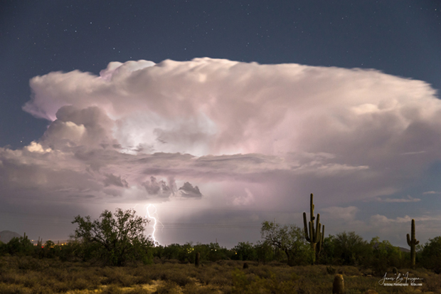
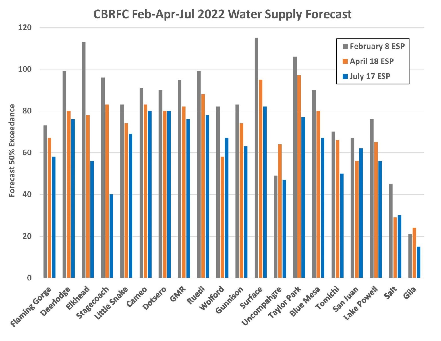
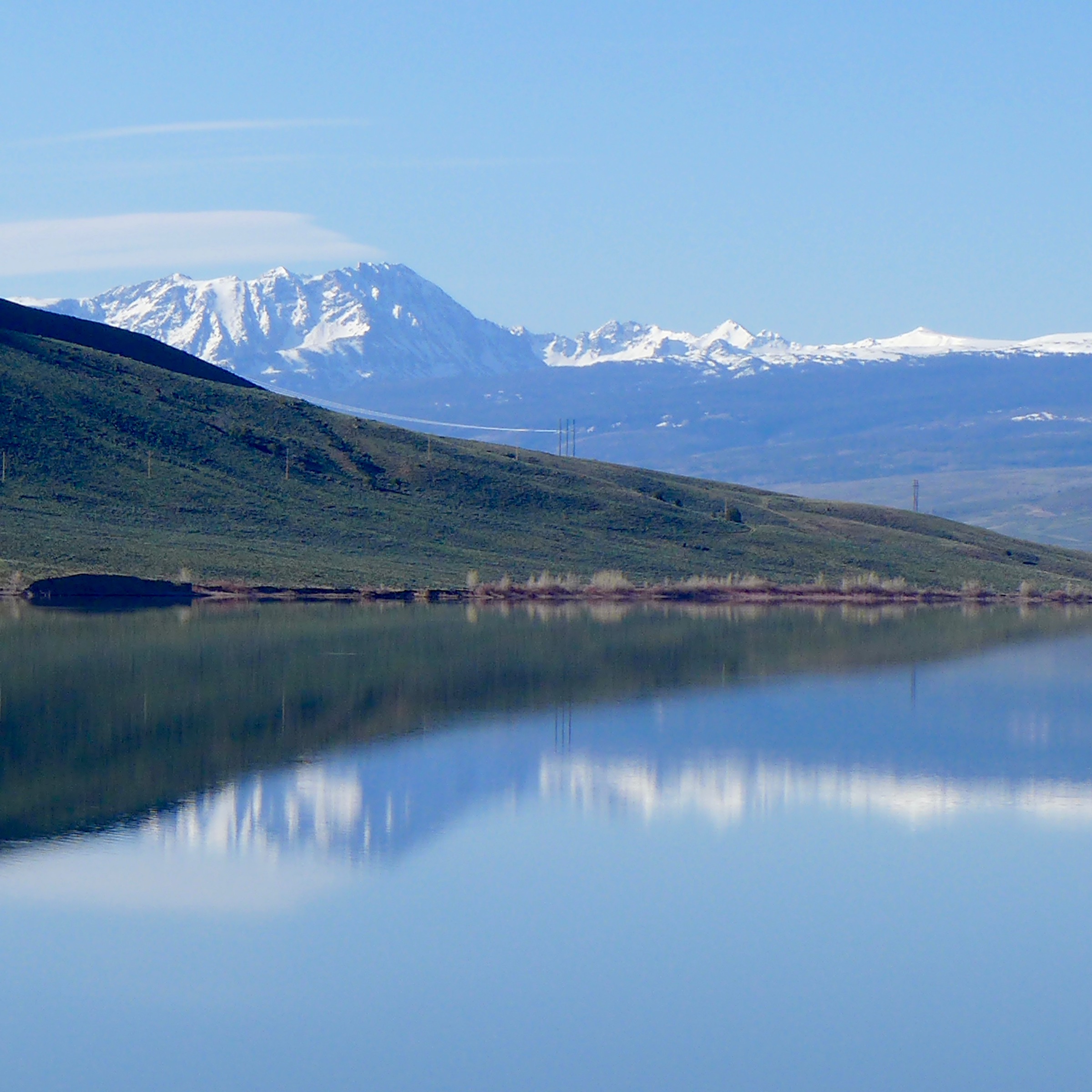

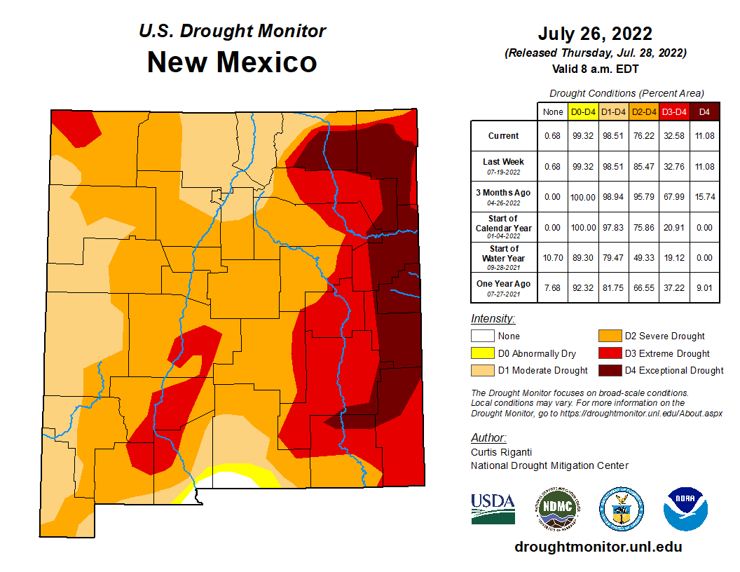


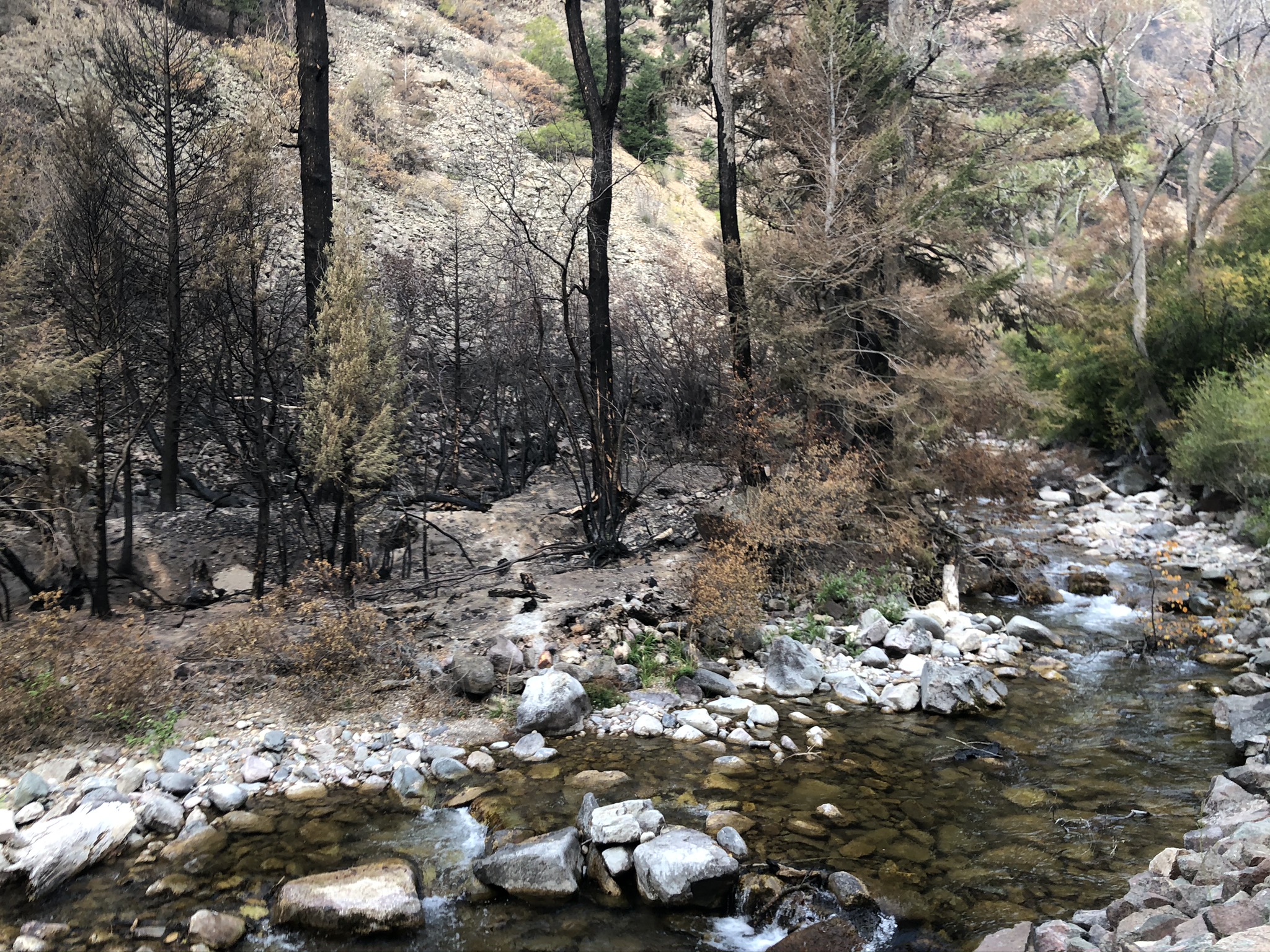
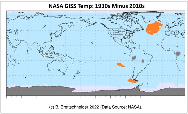


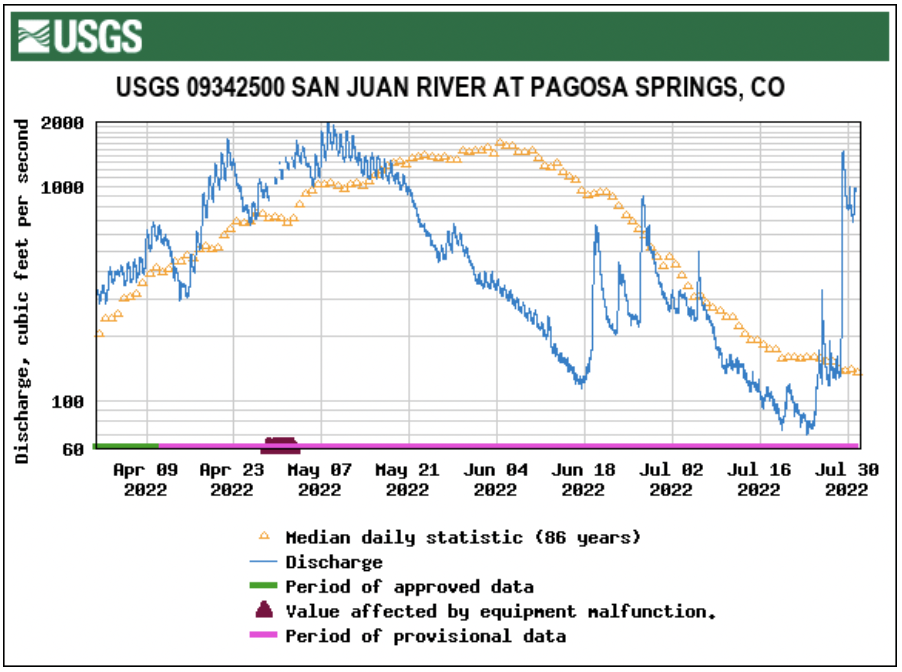
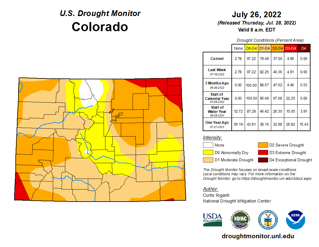


")