Short-term drought continued to rapidly expand across the Ohio, Tennessee, and Middle Mississippi Valleys along with parts of the Corn Belt. Thunderstorms brought locally heavy rainfall and drought relief to parts of the central to northern Great Plains. However, 7-day temperatures averaged above-normal throughout the Great Plains. A tropical disturbance in the western Gulf of Mexico and a trough of low pressure resulted in heavy rainfall and improving drought conditions to southeast Texas and southwest Louisiana. Convective rainfall was highly variable this past week across the Southeast with isolated amounts exceeding 3 inches while other areas remained mostly dry with worsening drought conditions. New England experienced a week of mostly dry weather and expanding drought coverage. Following the unusually heavy Monsoon rainfall during late June, heavy amounts were more localized this past week across New Mexico. Seasonal dryness prevailed throughout California, while much of the Pacific Northwest became drier after a wet spring. Drier-than-normal conditions persisted for much of Alaska into the beginning of July. A tropical wave of low pressure tracked northwest from the central Atlantic and brought heavy rainfall to eastern Puerto Rico…
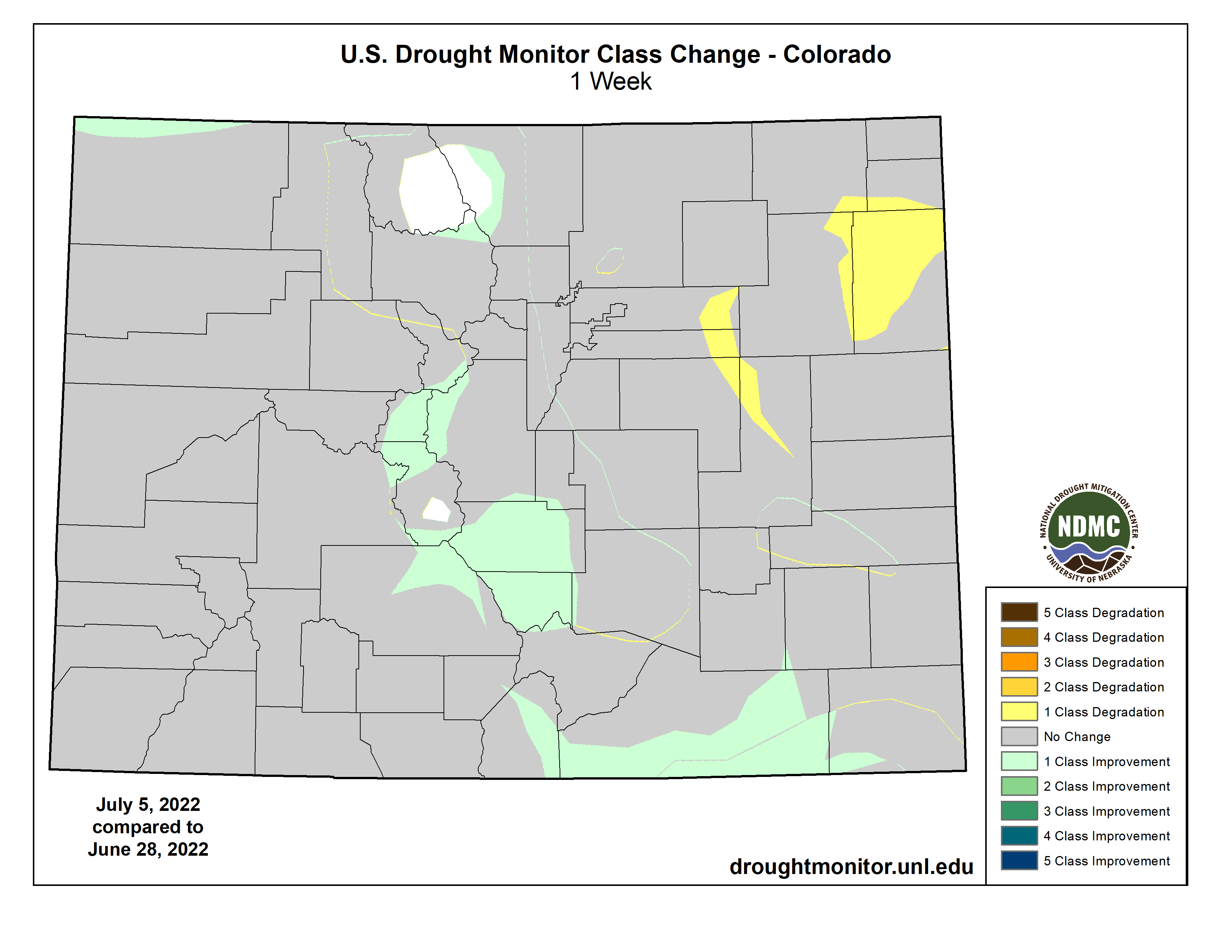
Locally heavy rainfall (more than 1 inch) this past week resulted in 1-category improvements to parts of Kansas, Nebraska, and South Dakota. Based on increasing short-term precipitation deficits and consistent with worsening soil moisture indicators, severe drought (D2) expanded across north-central Nebraska and extreme drought (D3) was added to more of northeastern Nebraska. Recent precipitation and reassessment of longer term SPI values supported a slight reduction of severe drought (D2) in southwestern Wyoming. Following a drier-than-normal June with above-normal temperatures (+3-4 degrees F), degradations were made to northeastern High Plains of Colorado. Recent monsoonal rainfall and the “convergence of evidence” of multiple indicators led to improvements for southern Colorado…
Colorado Drought Monitor one week change map ending July 5, 2022.
The North American Monsoon remained robust into the beginning of July, resulting in near to above normal precipitation across Arizona and New Mexico. Following the widespread 1-category improvement made the previous week throughout New Mexico, improvements were limited to areas of the heaviest rainfall. Additional improvements may be necessary in subsequent weeks depending on the Monsoon rainfall. Beneficial rainfall (more than 1 inch) continued to result in drought elimination across eastern Montana. Parts of north-central Montana have remained drier since the spring and extreme drought (D3) was expanded which was supported by soil moisture data. Drought coverage and intensity remained steady for the remainder of the West…
The rapid onset of drought continues to affect parts of the Tennessee and Lower Mississippi Valley with a continued increase in coverage of short-term moderate drought (D1). Western Tennessee and northern Mississippi were especially dry the past two weeks with many areas receiving less than 0.25 inches of rainfall. This dryness was combined with above-normal temperatures. Therefore, severe drought (D2) was added to parts of northern Mississippi and western Tennessee. 30-day SPEI, EDDI, and soil moisture indicators were used as guidelines in these degradations. Likewise, D0-D1 was also expanded across northeast Texas, southeast Oklahoma, and Arkansas. The number of Arkansas counties, designated with burn bans, continues to increase. In the 6 week period since May 25, Jonesboro, Arkansas has recorded 1.17″ of precipitation, or about 25% of normal. This is the driest such period since 1952. SPI values, starting at 120 days through the past 24 months, along with CPC’s leaky bucket soil moisture (lowest percentile) supported an expansion of D4 across the Texas Panhandle.
Closer to the Gulf Coast, heavy rainfall (more than 1.5 inches) resulted in widespread 1-category improvements to southern Louisiana and southeastern Texas. In areas that received more than 5 inches of rainfall such as southwest Louisiana, a 2-category improvement was justified. A small 2-category improvement was also made to northeastern Texas that received 3 to 6 inches of rainfall. Recent, heavy rainfall also led to a trimming of the extension of moderate drought (D1) across central Mississippi…
Looking Ahead
A major heat wave is forecast to affect much of the south-central U.S. through at least July 7 or 8 with the anomalous heat becoming centered across the Southern Great Plains and West by mid-July. A swath of heavy rainfall (1 to 3 inches, locally more) is forecast from the Middle Mississippi and Ohio Valleys southeastward to the Mid-Atlantic States from July 7 to 11. Mostly dry weather is expected for the Northeast, Gulf Coast States, Lower Mississippi Valley, and Southern Great Plains. Monsoonal rainfall is forecast to be lighter compared to late June.
The Climate Prediction Center’s 6-10 day outlook (valid July 12-16, 2022) favors above-normal temperatures throughout the West, Great Plains, and Gulf Coast States. Below-normal temperatures are more likely for the Great Lakes and Midwest. Below-normal precipitation is favored for the northern Great Plains and Middle to Upper Mississippi Valley. Probabilities for above-normal precipitation are elevated across eastern Alaska, the Great Basin, Southwest, Southern Great Plains, and along the East Coast.
Just for grins here are early July drought monitor maps for the past few years.
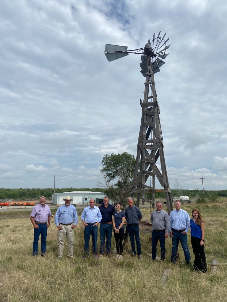
Today [July 6, 2022], Governor Jared Polis traveled across the Eastern Plains to hear directly from farmers, ranchers, and local leaders working to boost Colorado’s agriculture economy and to protect Colorado’s water.
This morning, Governor Polis, administration officials and community members visited Julesburg Gauge on the South Platte River to discuss water issues.
“It was great to be in Sedgwick, Phillips, Yuma, Kit Carson, Cheyenne, Kiowa, Lincoln, and Elbert counties hearing directly from producers and discussing how our administration is working together even more to protect Colorado’s water, grow Colorado’s thriving agriculture industry, and support our hardworking farmers and ranchers,” said Governor Polis.
Gov. Polis was then joined by the Commissioner of Agriculture Kate Greenberg, and toured Vision Angus, a local family owned ranch and farm in Phillips county that has been passed down for four generations. Vision Angus is a second year recipient of the Agricultural Workforce Development Program which aims to keep developing the next generation farmers and ensure our agriculture industries continued growth.
Governor Polis then headed to the South Republican State Wildlife Area and was joined by board members and other officials to discuss groundwater conservation in Yuma county. The Republican River Basin is supported by SB22-028, which was signed by Gov. Polis creates groundwater compact compliance and sustainability fund water conservation efforts in order to protect our water supply and retain irrigation systems in the river basins across Colorado. The Polis-Primavera administration is fighting to ease the effects of climate change induced drought seen across the state.
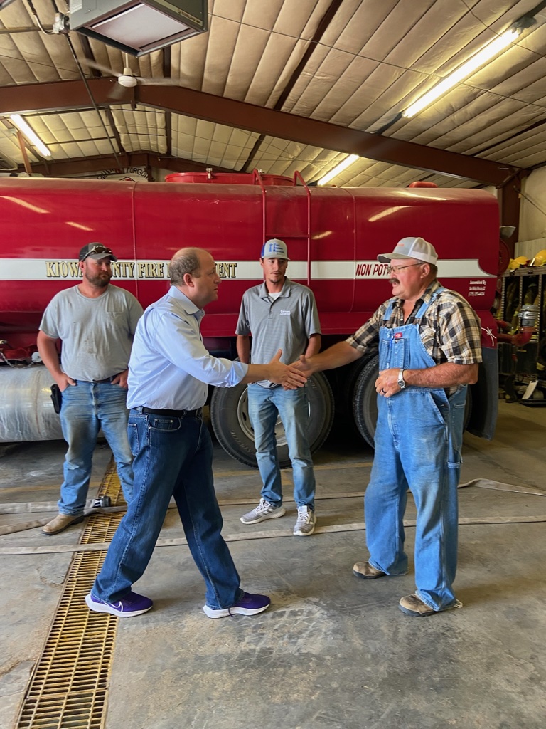
Governor Polis then visited the Eads Fire Department in Elbert county and met with first responders to discuss the Polis Administration’s continued support for first responders, including legislation that Governor Polis signed into law this year to provide additional resources and support for volunteer firefighters.
Governor Polis then traveled to Kit Carson county to visit the Old Town Museum. The museum is a historic site that has been restored to display the history of the Colorado Plains and local agriculture.
Governor Polis later traveled to Cheyenne county to sit down with local leaders and county commissioners from Cheyenne and Kiowa counties to discuss soil health and drought resilience efforts. Cheyenne Conservation District will receive support from SB22-195, a bipartisan law signed by Governor Polis which allocates additional annual funding for conservation districts across the state.
Governor Polis then visited two recipients of the Colorado Proud grant, Grant Grains and the Cleantec Mushroom Facility in Lincoln and Elbert counties, and where he discussed the administration’s support for producers and discussed tax relief for farmers including a bipartisan bill the Governor signed into law in the form of SB21-293.
(Gov. Polis in Phillips County touring Vision Angus family farm). Photo credit: Governor Polis’ office
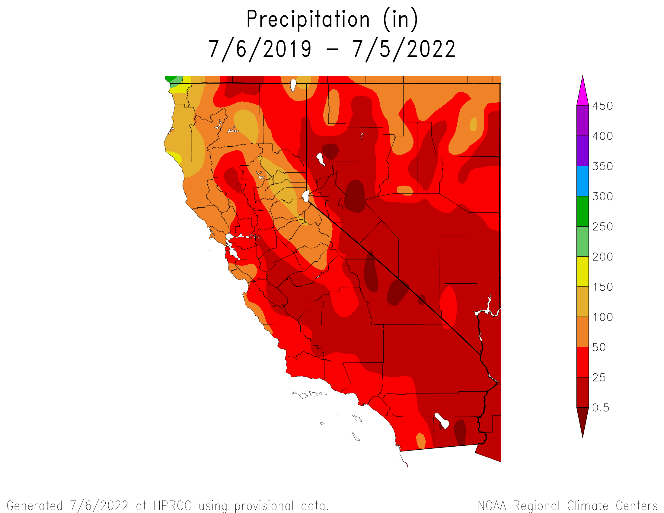
Click the link to read the article on the Sacramento Bee website (Dale Kasler). Here’s an excerpt:
In March the U.S. Environmental Protection Agency invited the backers of Sites Reservoir — a mammoth water storage project in the Sacramento Valley that’s being personally led by Durst — to apply for a $2.2 billion construction loan. The loan is far from a done deal, but the invitation means the EPA is seriously interested in backing the project, bringing Sites tantalizingly close to reality after years of planning.
“I was ecstatic. We finally convinced people this was a worthy project,” said Durst, chairman of the Sites Project Authority.
But the reservoir, planned for a spot straddling the Glenn-Colusa county line, 10 miles west of the Sacramento River, won’t dig California out of its current mega-drought. Even if all goes according to plan — a pretty big if — Sites wouldn’t finish construction until 2030. The status of Sites says a lot about how things stand in the third year of California’s terrible drought. There are no quick fixes, no immediate remedies. The only way out of this, for the time being, is conservation, forcing farmers and homeowners alike to make do with less water.
“What people have got to realize is,” Durst said, surveying one of his unplanted rice fields recently, “there’s no easy solutions left.”
[…]
A simple, non-controversial water project in rural south Sacramento County, designed to “bank” billions of gallons of water below ground as a reserve for drought periods, won’t be ready until late 2024. A more ambitious project, a multibillion-dollar recycling plant capable of putting a significant dent in the Los Angeles area’s water woes, is moving through the planning process but won’t produce drinkable water for another 10 years. The fact is, California is responding to the drought at something other than lightning speed. Its urban residents aren’t heeding Gov. Gavin Newsom’s call to cut their water usage by 15%. Since he made his plea last July, water savings total just 3%. And its public officials are struggling to get water-infrastructure projects over the finish line.
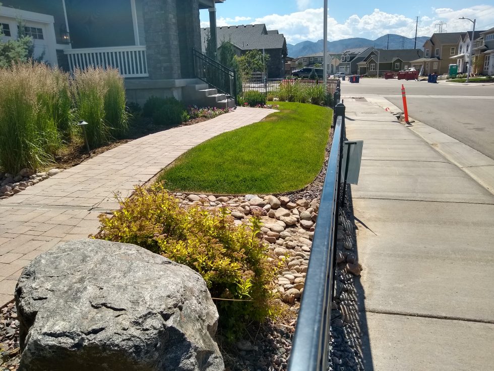
A small yard in Sterling Ranch, a Douglas County community that is the first in the state to undertake a rainwater harvesting project. June 27, 2022. Credit: Jerd Smith, Fresh Water News
Sterling Ranch, a conservation-oriented, fast-growing Douglas County community, is launching the first commercial effort to harvest rainwater in Colorado.
If the commercial pilot project succeeds, it could be used statewide to reduce water use in new developments, creating a supply of water that legally hasn’t existed before.
Andrea Cole is general manager of Dominion Water and Sanitation District, which serves Sterling Ranch. She said the project should prove that rain that runs off paved surfaces in developed areas can be used without harming natural water supplies that existed prior to development.
“When you change the landscape to a hardscape you produce more runoff,” Cole said. “The point is to capture the water off of a developed site without taking the water that would naturally be there.”
Sterling Ranch has been monitoring rainfall and infiltration of water into soils to ensure that the proposed collection system is gathering only the additional runoff from hard surfaces, and not the historic amount that the prairies collected pre-development.
Sterling Ranch must also convince its bigger neighbors, including Denver Water and Highlands Ranch, that Sterling’s rainwater collection is, in fact, a result of higher runoff from paved surfaces, not from the naturally occurring rain that falls in Douglas County.
“We’ve already heard from Denver and Centennial (the water district that serves Highlands Ranch) that we will have to prove we are not harming their water rights,” Cole said.
Swithin Dick, Centennial’s water rights administrator, said his agency was taking a wait-and-see approach to the rainwater pilot.
“If their application explains a project and plan that does not have the potential to injure Centennial’s water rights, and is consistent with existing law, it is not likely Centennial will oppose it,” Dick said via email.
Denver Water spokesman Todd Hartman said the agency had not yet taken a formal position on the project.
While collecting rainwater for drinking and irrigation is common elsewhere, it has been illegal in Colorado until recently because every drop of water that falls to the ground is owed to the rivers and streams, under the state’s 150-year-old allocation doctrine known as Prior Appropriation.
In 2016, Colorado legislators passed a law allowing individual homeowners to collect rainwater in two barrels per property with a combined storage capacity of up to 110 gallons, and also authorized a pilot program to see if a larger-scale, commercial effort could be done without harming downstream water users.
Harold and Diane Smethills began developing Sterling Ranch in 2004 and it now has 1,324 homes and will eventually have 12,050. The homes are among the most water-efficient that can be built and utilize small lots, hyper-efficient faucets and showers, and separate meters for indoor and outdoor water use.
Most Douglas County communities rely heavily on wells that tap water from deep, non-renewable aquifers, but heavy pumping over the years has lowered the aquifers’ levels. Water was already in short supply when Smethills first proposed Sterling Ranch, and he had to convince Douglas County planners that he could build the new development using much less water than the .75 acre-feet per single-family home the county required at the time. He also had to prove that he could do it using renewable surface water supplies in the South Platte River Basin.
He was eventually able to convince county planners that he could serve the community using .40 acre-feet of water per home, a number that now is closer to .20 acre-feet. An acre-foot equals 326,000 gallons, or enough to cover an acre of land with 12 inches of water.
Smethills and his team have been awarded two state grants worth roughly $111,500. The latest grant, awarded in March, will be used to help complete the feasibility studies and begin design work.
Cole said the project should generate 400 acre-feet of water annually that can be captured and used to irrigate the community’s small parks, allowing the community to use its existing supplies elsewhere.
But hurdles remain. Sterling Ranch may have to seek new legislation in the face of new stormwater rules that require separate storage facilities for stormwater and rainwater, Cole said, because the new rules would significantly increase the capital costs of the collection and distribution systen.
And as with almost all new water projects seeking a legal right to collect water, the project will have to go through an extensive review in a special water court, where anyone who has a water right in the region can submit concerns and challenge the process.
Sterling Ranch will apply to water court later this year, Cole said, and because of what she believes will be significant opposition, she expects it to take up to three years to complete the legal process and win the right to legally collect rainwater.
“Will there be opposition? Yes,” said Smethills, “Everybody else is watching to see how we do and if we can get it through water court. We’re at the bleeding edge. But this isn’t amateur night. We’ve spent millions of dollars to capture this data.”
Jerd Smith is editor of Fresh Water News. She can be reached at 720-398-6474, via email at jerd@wateredco.org or @jerd_smith.
Heavy rain combined with melting snow can be a destructive combination.
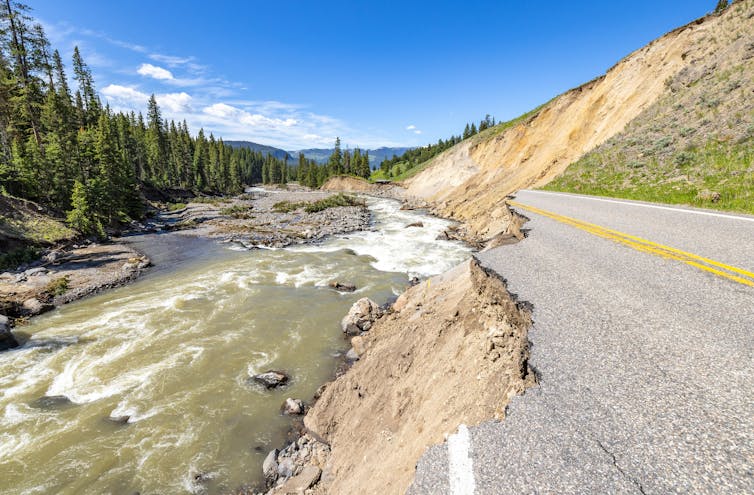
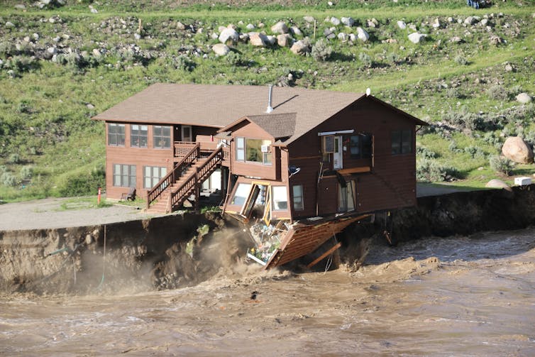
In mid-June 2022, storms dumped up to 5 inches of rain over three days in the mountains in and around Yellowstone National Park, rapidly melting snowpack. As the rain and meltwater poured into creeks and then rivers, it became a flood that damaged roads, cabins and utilities and forced more than 10,000 people to evacuate.
The Yellowstone River shattered its previous record and reached its highest water levels recorded since monitoring began almost 100 years ago.
Although floods are a natural occurrence, human-caused climate change is making severe flooding events like this more common. I study how climate change affects hydrology and flooding. In mountainous regions, three effects of climate change in particular are creating higher flood risks: more intense precipitation, shifting snow and rain patterns and the effects of wildfires on the landscape.
This occurs because warmer air can hold more moisture. The amount of water vapor that the atmosphere can contain increases by about 7% for every 1.8 degrees Fahrenheit (1 degree Celsius) of increase in atmospheric temperature.
Extreme rain storms triggered flooding and mudslides in Western Europe in 2021, killing more than 200 people. Thomas Lohnes/Getty Images
The latest assessment report published by the Intergovernmental Panel on Climate Change shows how this pattern will continue in the future as global temperatures continue to rise.
More rain, less snow
In colder areas, especially mountainous or high-latitude regions, climate change affects flooding in additional ways.
When rain falls on snow, as happened in the recent flooding in Yellowstone, the combination of rain and snowmelt can lead to especially high runoff and flooding.
In some cases, rain-on-snow events occur while the ground is still partially frozen. Soil that is frozen or already saturated can’t absorb additional water, so even more of the rain and snowmelt run off, contributing directly to flooding. This combination of rain, snowmelt and frozen soils was a primary driver of the Midwest flooding in March 2019 that caused over US$12 billion in damage.
While rain-on-snow events are not a new phenomenon, climate change can shift when and where they occur. Under warmer conditions, rain-on-snow events become more common at high elevations, where they were previously rare. Because of the increases in rainfall intensity and warmer conditions that lead to rapid snowmelt, there is also the possibility of larger rain-on-snow events than these areas have experienced in the past.
The 2022 Yellowstone flood inundated communities and swiftly eroded the land beneath this cabin that housed park employees. Gina Riquier via National Park Service
In lower-elevation regions, rain-on-snow events may actually become less likely than they have been in the past because of the decrease in snow cover. These areas could still see worsening flood risk, though, because of the increase in heavy downpours.
Compounding effects of wildfire and flooding
Changes in flooding are not happening in isolation. Climate change is also exacerbating wildfires, creating another risk during rainstorms: mudslides.
With the uptick in wildfires due to climate change, more and more areas are exposed to these risks. This combination of wildfires followed by extreme rain will also become more frequent in a future with more warming.
Global warming is creating complex changes in our environment, and there is a clear picture that it increases flood risk. As the Yellowstone area and other flood-damaged mountain communities rebuild, they will have to find ways to adapt for a riskier future.
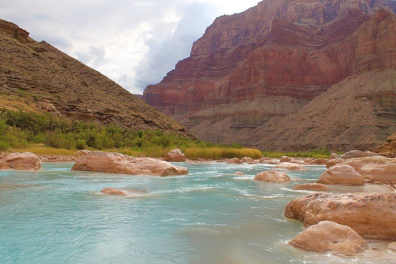
The Little Colorado River is best known for its milky blue waters that flow into the mainstem Colorado River in the Grand Canyon. These waters carry so much life-giving significance. For millennia, they have provided physical and spiritual sustenance for Indigenous peoples and supported plants, wildlife, communities, and more.
Grand Falls Little Colorado River, Spring of 2010.
But the Little Colorado River is not always blue. Sometimes it runs as thick and brown as chocolate milk. With a little knowledge of the river’s annual peaks and lows and an eye on the weather gauge, you can predict whether it will be brown or that remarkable turquoise blue.
So why and when is the Little Colorado River so blue?
Confluence of the Little Colorado River and the Colorado River. Climate change is affecting western streams by diminishing snowpack and accelerating evaporation. The Colorado River’s flows and reservoirs are being impacted by climate change, and environmental groups are concerned about the status of the native fish in the river. Photo credit: DMY at Hebrew Wikipedia [Public domain]
The source of its milky blue waters
The Little Colorado River gets its blue color from dissolved calcium carbonate in the water. This mineral is found in chalk, antacids, eggshells, dark green vegetables, rocks, and more. In the Little Colorado River, calcium carbonate forms a type of limestone called travertine that creates white, pillowy deposits along the riverbed. Most of the turquoise-blue water in the Little Colorado River comes from springs 10 to 13 miles upstream of the confluence. Thanks to these groundwater-fed springs, the last 13 miles of the Little Colorado River flow year-round at an average rate of 220 cubic feet per second (cfs) until joining the mighty Colorado River, which has an average flow between 8,000 and 25,000 cfs!
The Little Colorado River’s year-round flows are important for the region’s largest population of humpback chub. The warm, cloudy waters make excellent habitat for this threatened fish species.
Little Colorado River. Photo credit: Sinjin Eberle via American Rivers
Other colors of the Little Colorado River
When the Little Colorado River begins its journey from its headwaters in the White Mountains, its waters are not yet blue. The clear mountain stream flows north into the desert lands below, picking up sediment, minerals, and debris along the way. But less than 20 miles from its source, the Little Colorado River dries up. And for the next 300 miles, the river relies on precipitation to send water downstream. Modern-day water use is a major culprit of this dry stretch of the Little Colorado River. Year-round flows return near Blue Spring, 13 miles upstream of the confluence.
During two high runoff periods each year — in the spring from snowmelt and in the late summer from monsoon rains — the Little Colorado River runs red. During these periods, from February to April and July to September, the Little Colorado River may spike to 18,000 cfs. At this runoff level, the water can be so thick and muddy that placing your hand just an inch below the surface of the water makes it invisible to the naked eye.
The cultural significance of the Little Colorado River’s blue waters
The Little Colorado River’s blue waters have been of deep cultural significance to Native peoples since time immemorial. At least 10 tribes have traditional connections to what Zuni people refer to as “the umbilical cord” of the world. For Hopi people, the Little Colorado River is the home of their emergence story, and its waters, springs, and salt remain important to this day. Adjacent Diné (Navajo) communities, whose land may be affected by proposed dam development, are considering a sacred site designation for the area to prevent development threats like the former Escalade tram proposal.
But to truly understand the importance of the Little Colorado River, I suggest you go directly to the source. Visit the Lifeways of the Little Colorado River collection to hear 11 Native voices share their personal and cultural ties to this life-sustaining river.
Low flows during drought on the Crystal River. Photo credit: Colorado Water Trust
Here’s the release from the Colorado Water Trust and the Cold Mountain Ranch (Alyson Meyer Gould and Bill Fales):
Cold Mountain Ranch and Colorado Water Trust finalized an agreement intended to increase streamflow in the Crystal River in drier years. The six-year agreement will compensate the Cold Mountain Ranch owners, Bill Fales and Marj Perry, for retiming their irrigation practices to leave their irrigation water in the Crystal River when the river needs it most.
The Crystal River, in 2012, was listed as the eighth most endangered river in the country by American Rivers. It is still a struggling river today. Owing to diversions off the river and the impacts of climate change decreasing snowpack, it runs very low or dry in most years. This impacts the fish and wildlife that depend on it. Colorado Water Trust and Cold Mountain Ranch are trying to help. This innovative agreement would provide the ranch the opportunity to add flows to their local river when it needs it most and hopefully contribute to a healthier aquatic and riparian habitat for those that depend on it. Together, we aim to show that agriculture and conservation can go hand in hand.
Cold Mountain Ranch relies on the Crystal River to irrigate pastures and hay fields that support its cow-calf operation. Under the agreement, Colorado Water Trust will monitor flows in the river and if flows fall to 40 cubic feet per second (cfs) in August or September, the ranch may voluntarily decide to shift its irrigation schedule to allow Colorado Water Trust to lease the water for environmental benefit. Colorado Water Trust will monitor and measure the changed practice and pay the ranch a $5,000 bonus for signing the agreement at the outset of the five-year contract and then $250 per cfs per day to encourage that shift. Once streamflows reach 55 cfs, payments would cease. The agreement can restore up to 6 cfs in the Crystal River.
In 2018, Colorado Water Trust and Cold Mountain Ranch signed a similar three-year pilot agreement that ended in 2020. Unfortunately, within this initial three-year period, Colorado Water Trust and Cold Mountain Ranch were unable to run the project. In 2018, the Crystal River’s flows were too low to implement the agreement – there was not enough water available to result in significant benefits instream. In 2019, the river was high enough to avoid triggering the agreement during the timeframe of the agreement. Although it flirted with the low flow trigger in the late fall, the timing was out of range for the agreement. And in 2020, because of dry and hot conditions and impacts to their irrigated crops, Colorado Water Trust’s partners at Cold Mountain Ranch needed to use as much water as possible to maximize their late season production and keep their ranching operation sustainable.
Colorado Water Trust and Cold Mountain Ranch’s initial three-year pilot agreement was the first crack at a highly customized, market-based solution that works for agriculture and rivers on the Crystal River, and offered lessons for the renewal and re-tooling of that initial agreement. In this new six-year contract, the partners tried to account for drier years and changing climatic conditions, as well as the economic needs of the Ranch. The changes include a $5,000 bonus to support agricultural operations, additional payment and flexibility for coordination, and extending potential coordination into October.
One of the most important goals of Colorado Water Trust’s work on the Crystal River was to design a solution that allows water rights owners to maintain healthy agricultural operations – and Colorado Water Trust continues to accomplish that goal.
Our past agreement also shows other ranchers on the Crystal River that when we say our solutions are voluntary and are NOT designed to harm their operations, we mean it. The vision for this project is that other ranchers on the Crystal River will see that Cold Mountain Ranch is fully empowered to make their own decisions in the best interest of their business, and will feel comfortable to sign on to the project as well. The Crystal River needs more water than just that of Cold Mountain Ranch’s and we hope others will get involved to maintain a healthy river.
ABOUT COLORADO WATER TRUST: Colorado Water Trust is a statewide, nonprofit organization that restores water to Colorado’s rivers in need. Colorado Water Trust accomplishes its mission with voluntary, market-based projects.