Black Canyon July 2020. Photo credit: Cari Bischoff
From email from Reclamation (Erik Knight):
Releases from the Aspinall Unit will be increased from 1450 cfs to 1500 cfs on Wednesday, July 20th. Releases are being increased to maintain flows above the baseflow target on the lower Gunnison River. The forecasted April-July runoff volume for Blue Mesa Reservoir is 67% of average.
Flows in the lower Gunnison River are currently very near to the baseflow target of 900 cfs. River flows are expected to drop below the baseflow target without this additional increase in release from the Aspinall Unit.
Pursuant to the Aspinall Unit Operations Record of Decision (ROD), the baseflow target in the lower Gunnison River, as measured at the Whitewater gage, is 900 cfs for June, July and August.
Currently, Gunnison Tunnel diversions are 1030 cfs and flows in the Gunnison River through the Black Canyon are around 440 cfs. After this release change Gunnison Tunnel diversions will still be around 1030 cfs and flows in the Gunnison River through the Black Canyon will be near 490 cfs. Current flow information is obtained from provisional data that may undergo revision subsequent to review.
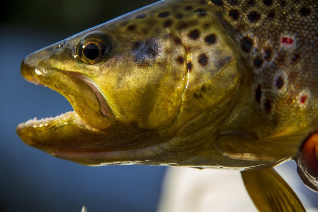
District calls on Front Range diverters to assist in prevention of further fish kills, economic impairment.
Low flows and high water temperatures are creating critical conditions on the Upper Colorado for the second consecutive year, triggering fishing closures amidst reports of struggling and dying fish. Anticipating these conditions, the Colorado River District chose to release water from an already-reduced Wolford Mountain Reservoir last weekend. This voluntary release generated approximately 200 acre-feet of water to protect the health of the river – and by extension, local economies and downstream water users. District staff, however, says further action is needed.
“Our constituents are seeing fish floating by belly-up and struggling to survive current hot temperatures,” said Brendon Langenhuizen, the River District’s Director of Technical Advocacy. “We’ve also received reports of dead fish along the riverbanks. Since the beginning of July, these new-normal conditions are having major impacts on the Upper Colorado River ecosystem. Colorado Parks & Wildlife’s fishing closures are symptomatic of a larger issue that needs the attention of all water users. Our District has and will continue to do our part with voluntary releases when water is available from our limited resources at Wolford Mountain Reservoir.”
Wolford Mountain Reserovir, and the Gore Range. Photo: Brent Gardner-Smith/Aspen Journalism
Recent monsoonal rains are bringing some relief, but soil moisture issues and hot, dry conditions forecasted for early next week have prompted a need for direct action. In response, the River District began releasing an additional 50 cubic feet-per-second (cfs) Friday morning, July 15, and will continue through Sunday, July 17, providing another 300 acre-feet of water for the river by Monday morning. Limited West Slope water supplies will inhibit the River District’s ability to fully address temperature and flow issues, however.
“We can’t fix this situation alone,” Langenhuizen stated. “Our constituents are asking for help to address the river’s unhealthy conditions causing fish kills. They’re wondering why large Front Range providers are not reducing their transmountain diversions to join the River District in aiding Colorado’s namesake river and the livelihoods it supports.”
The River District urges these water providers to act in partnership with West Slope water users to protect the health of the Upper Colorado River.
Colorado River just after crossing under highway 34. Photo credit: Colorado River District
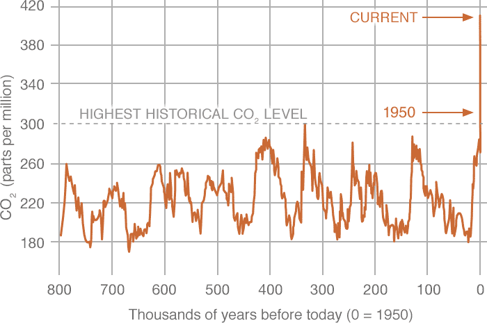
PROXY (INDIRECT) MEASUREMENTS Data source: Reconstruction from ice cores. Credit: NOAA
Click the link to go to the NASA website for all the inside skinny and to use the interactive map:
Carbon Dioxide
LATEST MEASUREMENT: June 2022
419 ppm
Carbon dioxide (CO2) is an important heat-trapping gas, or greenhouse gas, that comes from the extraction and burning of fossil fuels (such as coal, oil, and natural gas), from wildfires, and from natural processes like volcanic eruptions. The first graph shows atmospheric CO2 levels measured at Mauna Loa Observatory, Hawaii, in recent years, with natural, seasonal changes removed. The second graph shows CO2 levels during Earth’s last three glacial cycles, as captured by air bubbles trapped in ice sheets and glaciers.
Since the beginning of industrial times (in the 18th century), human activities have raised atmospheric CO2 by 50% – meaning the amount of CO2 is now 150% of its value in 1750. This is greater than what naturally happened at the end of the last ice age 20,000 years ago.
The animated map shows how global carbon dioxide has changed over time. Note how the map changes colors as the amount of CO2 rises from 365 parts per million (ppm) in 2002 to over 400 ppm currently. (“Parts per million” refers to the number of carbon dioxide molecules per million molecules of dry air.) These measurements are from the mid-troposphere, the layer of Earth’s atmosphere that is 8 to 12 kilometers (about 5 to 7 miles) above the ground.
U.S. Highway 287 runs through the future site of Glade Reservoir. The Larimer county Board of County Commissioners approved the 1041 Land Use Permit for NISP in September, 2020. Photo credit: Northern Water
Click the link to read the article on the Fort Collins Coloradoan website (Sady Swanson and Jacy Marmaduke). Here’s an excerpt:
Crews began conducting rock and soil assessments in June at the site of the planned Glade Reservoir, north of Ted’s Place on U.S. Highway 287. The assessments will give Northern Colorado Water Conservancy District officials site-specific geotechnical and geological information that will inform the design and construction of the Glade Reservoir dam…
The assessment work is expected to continue through November, according to a Northern Water news release. This work includes:
Digging a 1,000-foot-long trench at the main dam site to test materials and drill the foundation
Building a test pad of embankment material types
Producing aggregates and rock fill from quarries and investigating material characteristics
This work is being done ahead of the project’s anticipated approval by the U.S. Army Corps of Engineers, which is expected to make its final determination this year. If that happens, construction could start as early as 2023 with completion expected by 2028.
Northern Integrated Supply Project (NISP) map July 27, 2016 via Northern Water.
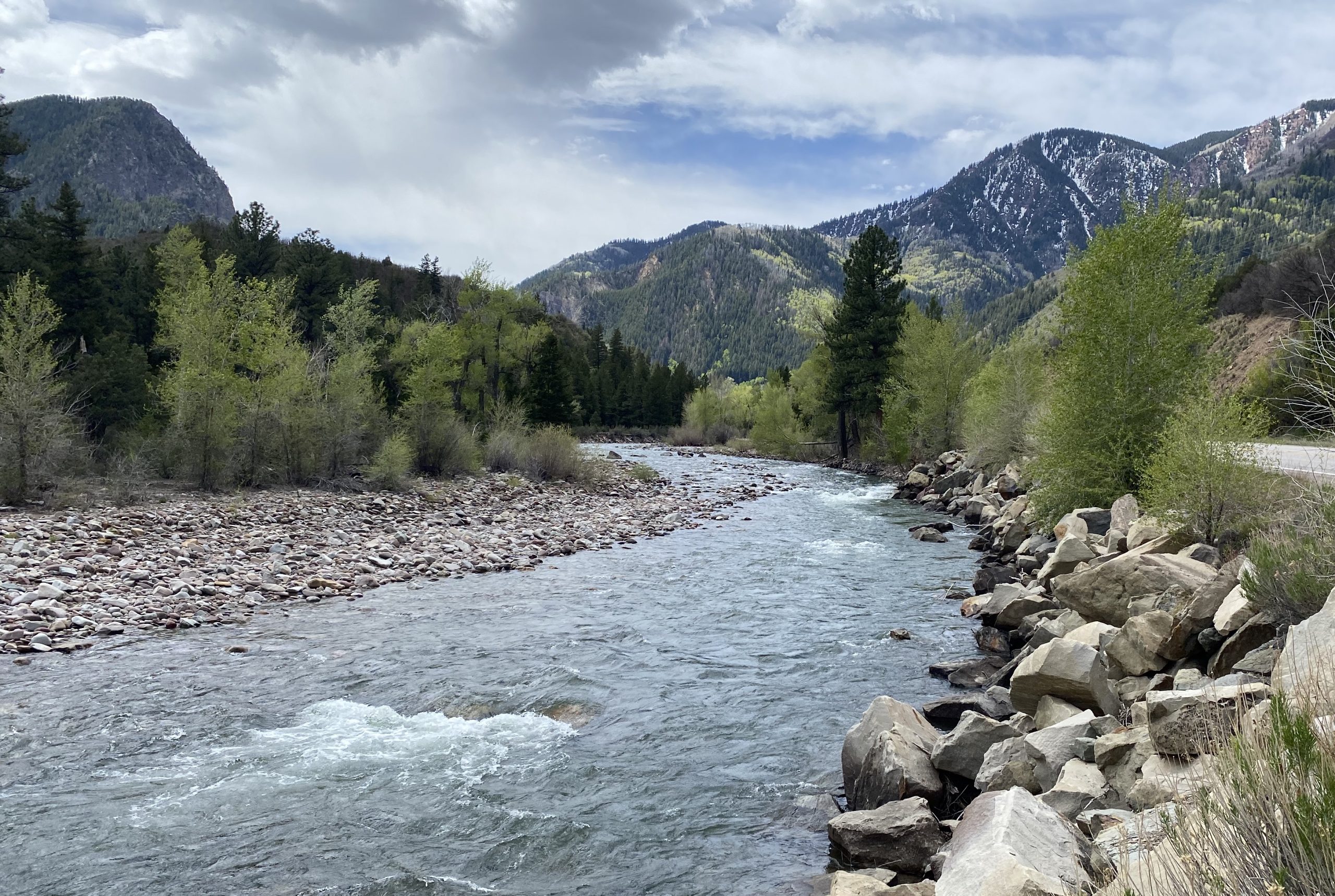
State Highway 133 crosses the Crystal River several times as it flows downstream to its confluence with the Roaring Fork River in Carbondale. Some proponents of a federal Wild & Scenic designation are pushing for a quick timeline while others want a more cautious approach. CREDIT: HEATHER SACKETT/ASPEN JOURNALISM
A campaign to protect one of the last free-flowing rivers in Colorado is moving forward, but some proponents say not enough progress has been made over the past year.
Last spring a handful of advocates led by Pitkin County revived an effort to secure a federal Wild & Scenic designation, which would protect the upper Crystal River from future development, dams and diversions. A year into the effort, some say a planned stakeholder process is moving too slowly, while others say a designation can’t be rushed and must be approached carefully and inclusively.
The different philosophies underscore a rift between those who say a cautious and thorough multi-year approach is what’s needed to ensure success and those who say mounting threats to the river, driven by the climate crisis, demand bold and immediate action.
“That difference of opinion concerns me a great deal,” said Kate Hudson, Crystal River Valley resident and western U.S coordinator for Waterkeeper Alliance. “We are at an existential moment both in terms of water and climate and our congressional balance of power that requires we at least try and do this faster. We should at least try to move this as quickly as possible.”
In 2021 Pitkin County Healthy Rivers granted $35,000 to Carbondale-based environmental conservation group Wilderness Workshop to start up a public outreach and education campaign, with the goal of laying a foundation of grassroots support for the effort. The organization has built a website, held events and collected about 1,000 signatures on a petition supporting the designation. The next step will be working with Pitkin County to hire a facilitator for a formal stakeholder process.
At the June Healthy Rivers board meeting, Wilderness Workshop’s Wild & Scenic campaign manager Michael Gorman gave a presentation about progress so far. Board member Wendy Huber asked about the timeline and whether the process should be moving faster. Gorman said a designation could take several more years.
“I’m feeling a little urgency,” she said. “To sort of dilly dally seems to be losing opportunities.”
Grant Stevens, communications director for Wilderness Workshop, said that while he understands the community’s urgency, it’s important to develop a proposal that Colorado’s congressional representatives can get behind. A designation must be approved by Congress and advocates have been in contact with representatives from Sens. Michael Bennet and John Hickenlooper’s offices.
“We want to make sure we have something that a federal elected official will support, and we need to make sure we go through a community-driven process to get to that point,” Stevens said. “We don’t want to rush that.”
The view looking upstream on the Crystal River below Avalanche Creek. A Pitkin County group wants to designate this section of the Crystal as Wild & Scenic. CREDIT: CURTIS WACKERLE/ASPEN JOURNALISM
Designation details
The U.S. Forest Service first determined in the 1980s that the Crystal River was eligible for designation under the Wild & Scenic River Act, which seeks to preserve rivers with outstandingly remarkable scenic, recreational, geologic, fish and wildlife, historic and cultural values in a free-flowing condition. There are three categories under a designation: wild, which are sections that are inaccessible by trail, with shorelines that are primitive; scenic, with shorelines that are largely undeveloped, but are accessible by roads in some places; and recreational, which are readily accessible by road or railroad and have development along the shoreline.
The potential proposal for the Crystal includes all three types of designation: wild in the upper reaches of the river’s wilderness headwaters, scenic in the middle stretches and recreational from the town of Marble to the Sweet Jessup canal headgate. Each river with a Wild & Scenic designation has unique legislation written for it that can be customized to address local stakeholders’ values and concerns.
Cache la Poudre River from South Trail via Wikimedia Foundation.
Despite its renowned river rafting, fishing and scenic beauty, which contribute to the recreation-based economy of many Western Slope communities, Colorado has just 76 miles of one river — the Cache La Poudre — designated as Wild & Scenic. This underscores the difficulty of trying to preserve free-flowing streams, especially in a water-scarce region where some would like to see rivers remain available for future water development.
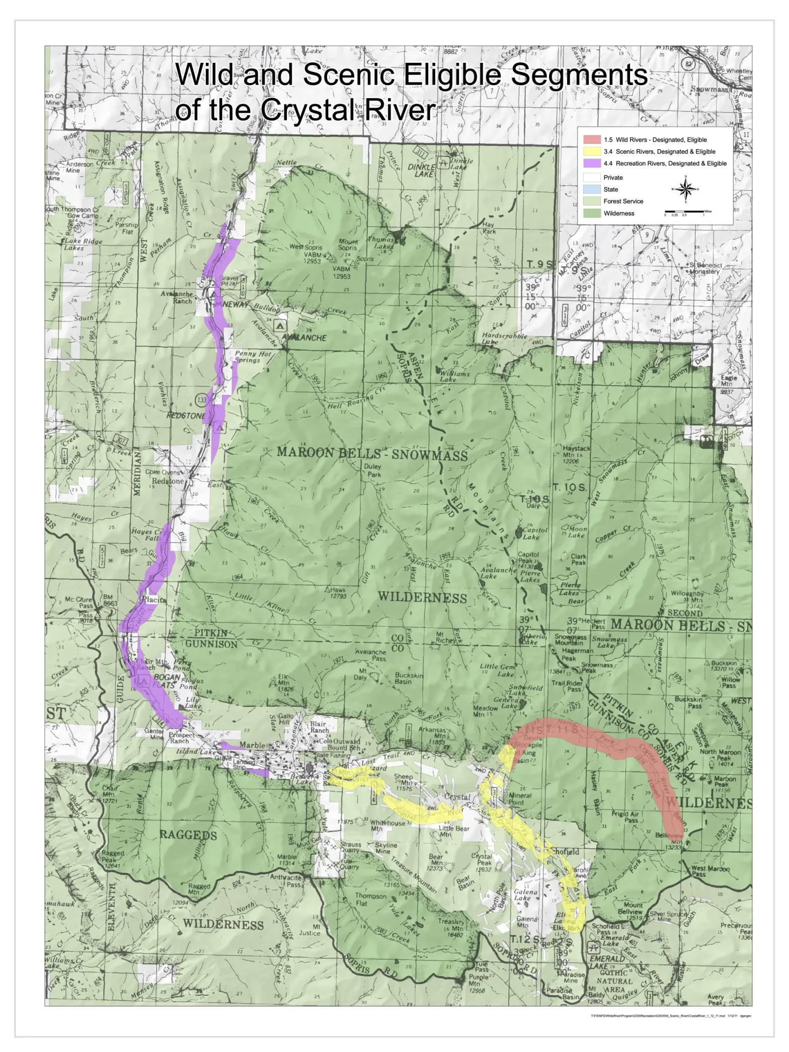
This map shows the sections of the Crystal River that could be designated wild, scenic and recreational according to the finding of eligibility by the U.S. Forest Service. CREDIT: COURTESY ROARING FORK CONSERVANCY
Stakeholder participation
Since the Crystal flows through Gunnison County and the town of Marble, advocates say getting those residents and elected representatives on board will be key to moving the effort forward. A first attempt at a Wild & Scenic designation, which sought to prevent the possibility of a future dam and reservoir project, couldn’t get buy-in from some Marble residents or Gunnison County. Advocates shelved the discussion in 2016 with the election of President Donald Trump. This time around, they hope to secure at least the participation if not the support of past opponents.
Marble Town Administrator Ron Leach acknowledged there is still a lot of work to be done as far as gauging public sentiment and building awareness.
Leach has been heavily involved in the town’s multi-year process to address overcrowding on the Lead King loop, a popular off-highway vehicle route near Marble. He said when it comes to these things, slow and methodical is the right strategy and that town officials are totally supportive of the Wild & Scenic stakeholders group, in which he participates as the Marble representative.
“The more process, the better the product,” Leach said. “I’ve learned that the hard way. Take it easy and make sure it’s right.”
Gunnison County Commissioner Roland Mason agreed. He said more conversations need to happen before he could say whether Gunnison County would support a designation.
“I appreciate the fact that they are not trying to rush the timeline,” Mason said. “From my perspective it’s moving at a little bit of a slow pace because of trying to get everyone on board but at the same time, it’s kind of necessary.”
But supporters may never get everyone on board. Larry Darien, who owns a ranch on County Road 3 that borders the river, was one of the early opponents to the designation and still remains opposed to Wild & Scenic because of its potential effect on private property.
While the Wild & Scenic Rivers Act does give the federal government the ability to acquire private land, there are many restrictions on those abilities. Condemnation is a tool that is rarely used, according to a Q&A document compiled by the Interagency Wild and Scenic Rivers Coordinating Council.
“I’m not in favor of a dam on the Crystal River and I’m not in favor of water being taken out and sent someplace else and I’m not in favor of Wild & Scenic designation,” he said. “There are other ways we can manage this besides Wild & Scenic and I think that’s the way we need to go instead of getting the federal government involved.”
The alternate route Darien is referring to is a collaboratively created alternative management plan on the Upper Colorado River, which offers some of the same protections as Wild & Scenic, but still allows for some water development.
Advocates will have to decide whether total consensus is a realistic goal and if they should move forward even though some opposition remains.
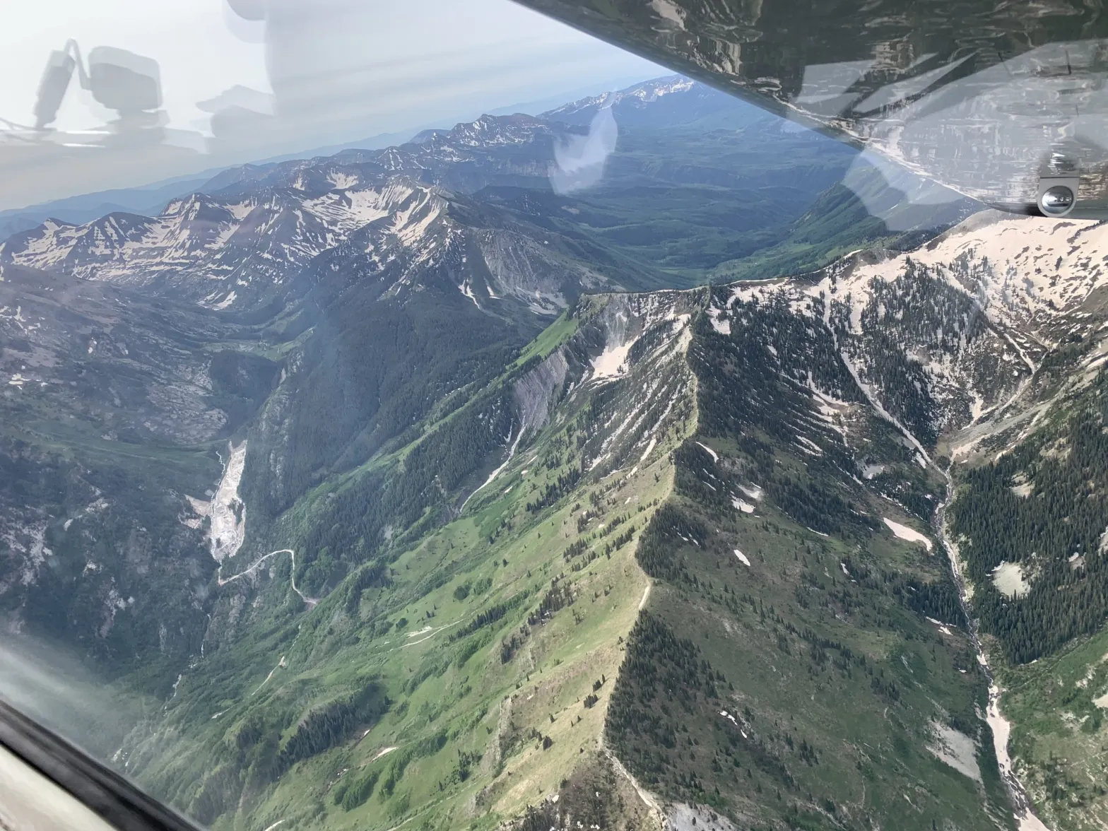
he headwaters of the Crystal River include the tributary of Yule Creek, the drainage seen to the left from an Eco-Flight, where Colorado Stone Quarries’ marble quarry is located. Some, including Pitkin County, would like to see the Crystal River designated under the federal Wild & Scenic River Act. CREDIT: HEATHER SACKETT/ASPEN JOURNALISM
Threats to the Crystal?
While there may be a general feeling of worry about drought and falling reservoir levels in the Colorado River basin overall, it’s unclear what — if any — specific, imminent threats there are to the upper Crystal River. In 2012, conservation group American Rivers deemed the Crystal one of the top 10 most endangered rivers. This was spurred by plans, which have since been scrapped, from the Colorado River Water Conservation District and the West Divide Conservation District to preserve water rights tied to reservoirs near Redstone.
Still, in a place where much of the state’s headwaters are taken across the Continental Divide to thirsty Front Range cities, Wild & Scenic proponents say it could happen on the Crystal, even if those threats are currently hypothetical. Many of Colorado’s rivers have been overly tapped, but there’s still water left to develop on the Crystal.
“To me, the greatest threat to the Crystal isn’t so much the storage facility, it’s that there’s still water in the Crystal,” said Pitkin County Attorney John Ely. “The biggest risk to the Crystal is just taking water out of the drainage. That’s why I think the (Wild & Scenic) effort is still worth doing.”
Aspen Journalism covers water and rivers in collaboration with The Aspen Times.