Click the link to read the article on the Loveland Reporter-Herald website (Dallas Heltzell |). Here’s an excerpt:
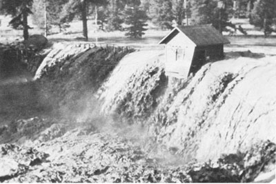
A disaster 40 years ago today changed the face of downtown Estes Park, and its tourism-dependent businesses still are reaping the benefits of a landscaped riverwalk and other improvements…Lawn Lake, at 10,789 feet at the headwaters of Roaring River in what now is Rocky Mountain National Park and eight miles west of Estes Park, originally was a 16.4-acre natural body of water dammed by a glacial moraine. However, in 1903, 12 years before the park’s founding, the Farmers Irrigation Ditch and Reservoir Co. added a dam to supply water to farmlands around Loveland. By 1982, the reservoir covered 48 acres and was up to 35 feet deep. The dam was allowed to remain when the park was founded, but access for maintenance and inspections deteriorated over the years…
Within six weeks after the flood, town trustees approved the EPURA, and the foundation paid the legal costs to develop the ordinance needed. Gov. Dick Lamm obtained a federal disaster declaration from President Ronald Reagan, and the Federal Emergency Management Agency “took over the overall management of trying to put the town together again,” Rosener said. “They were tremendous.”
Foundation members recruited urban designers and “convinced the town to hire them,” Rosener said, “and we created an urban renewal plan. All of my team worked over the next 12 to 14 months to create the plan, construction began in 1984 and was done in about two years.”
One building at the intersection of Elkhorn Avenue and Riverside Drive had to be demolished to make way for the design’s Confluence Park, where the Fall and Big Thompson rivers met, Rosener said. Along Elkhorn, narrow sidewalks were widened and parallel parking eliminated. Private businesses were encouraged to update their properties, Rosener said, and tearing up Elkhorn Avenue to redo it revealed “a main waterline made out of wood slats wrapped in steel bands. There were all kinds of issues with telephone and gas — it was just a spider web when they opened up Elkhorn.” Because East Elkhorn Avenue carried U.S. Highways 34 and 36, “we had to convince the state to give up one lane of traffic” — a decision that aided the beautification but also, three decades later, fueled the controversial one-way “Loop” proposal. But the result, Thomas said, was that “the new urban-renewal authority formed after the flood beautified the town and created a streetscape that totally changed the face of downtown” and provided a venue for some new river-facing businesses. “Instead of having these ugly areas behind stores, they turned the focus back toward the rivers. Now we have the riverwalk, we have park benches, we have new lighting. We have trees planted along Elkhorn Avenue. All of that was the result of the Lawn Lake flood.”