Navajo Reservoir, New Mexico, back in the day.. View looking north toward marina. The Navajo Dam can be seen on the left of the image. By Timthefinn at English Wikipedia – Transferred from en.wikipedia to Commons., Public Domain, https://commons.wikimedia.org/w/index.php?curid=4040102
From email from Reclamation (Susan Novak Behery):
In response to low flows in the critical habitat reach and increased irrigation, the Bureau of Reclamation has scheduled an increase in the release from Navajo Dam from 500 cubic feet per second (cfs) to 700 cfs for today, Wednesday, July 13th at 12:00 PM, and additional increase from 700 cfs to 800 cfs at 2:00 PM.
Releases are made for the authorized purposes of the Navajo Unit, and to attempt to maintain a target base flow through the endangered fish critical habitat reach of the San Juan River (Farmington to Lake Powell). The San Juan River Basin Recovery Implementation Program recommends a target base flow of between 500 cfs and 1,000 cfs through the critical habitat area. The target base flow is calculated as the weekly average of gaged flows throughout the critical habitat area from Farmington to Lake Powell.
Click the link to read the article on the NOAA website:
Exacerbated by a record-dry June, Alaskan wildfires grow at near-record pace
Key Points:
Credit: NOAA
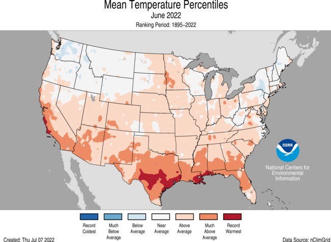
The average temperature of the contiguous U.S. in June was 70.7°F, which is 2.2°F above average, ranking 15th warmest in the 128-year record. Temperatures across much of the southern half of the Lower 48 as well as from the northern Plains to the Ohio Valley were above average.
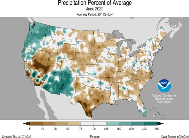
June precipitation for the contiguous U.S. was 2.33 inches, 0.60 inch below average, tying with 1930 for 12th driest in the historical record. Precipitation was above average across portions of the Northwest and Southwest. Precipitation was below average in the Great Basin, from the central Rockies to the Great Lakes, across the Deep South and from the mid-Mississippi Valley to the Southeast.
Integrated across the state, precipitation across Alaska ranked driest on record for June and was 0.04 inch less than the previous record set in 1934.
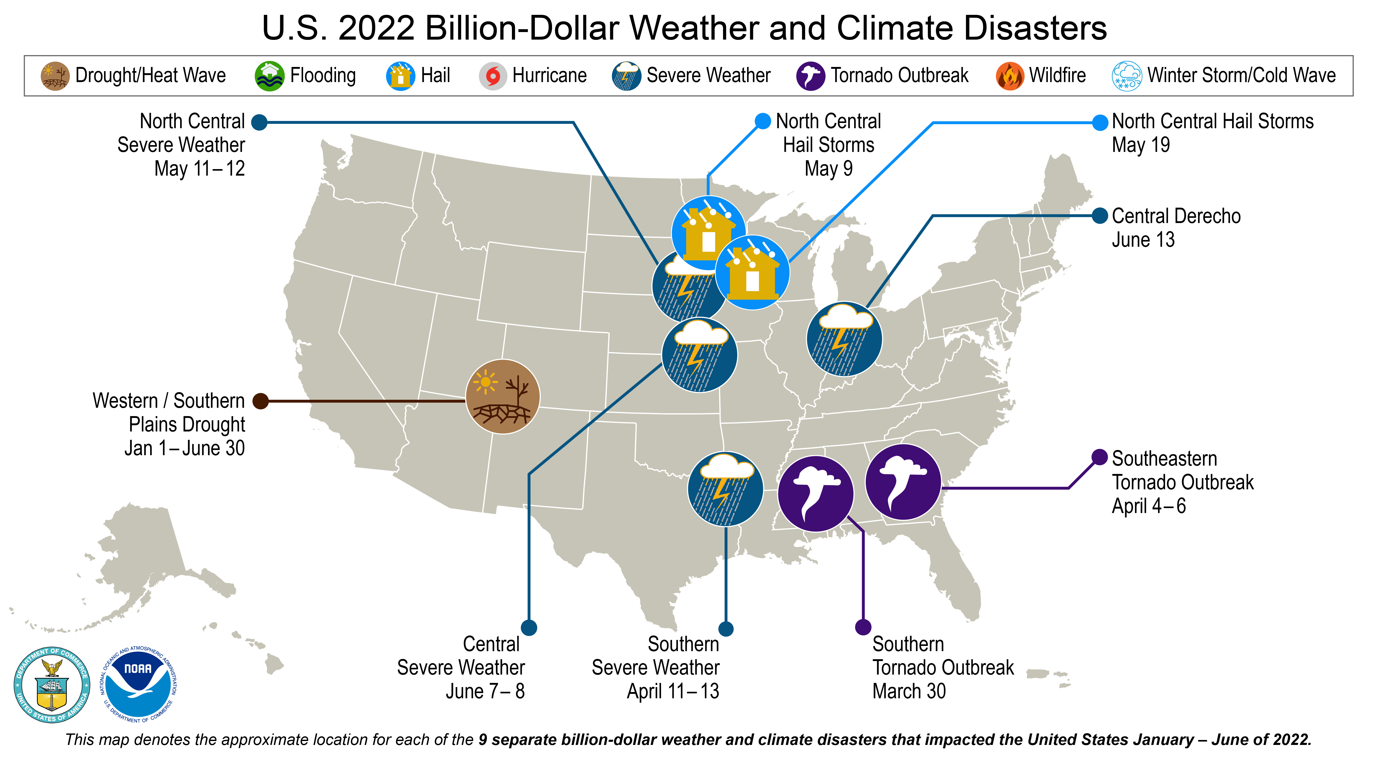
There were nine billion-dollar weather and climate disasters identified during January-June, the fifth-highest disaster count in the 43-year record for this year-to-date period. These disasters consisted of eight severe storm events and one drought event.
The wildfire season continues as large fires burn across portions of the South and Southwest and have grown rapidly across Alaska. Across all 50 states, more than 3.9 million acres have burned from January 1 through June 30 — nearly 2.3 times the average for this time of year.
According to the June 28 U.S. Drought Monitor report, 47.7 percent of the contiguous U.S. was in drought. Due to monsoon rains, parts of the Southwest saw a reduction in extreme to exceptional drought, but drought conditions erupted and/or expanded across parts of the mid-Mississippi Valley and Southeast.Puerto Rico has been in drought for a record 81 consecutive weeks.
Other Highlights:
Temperature
Credit: NOAA
Above-average warmth, associated with a ridge of high pressure, dominated much of the contiguous U.S. during June. Several Southern Tier states had a top-10 warmest June on record including Texas, ranking fifth warmest on record for the month. This is the third consecutive month of extreme heat across Texas, which resulted in a ranking of warmest on record for the April-June period.
Averaged over the first half of the year, the contiguous U.S. temperature was 48.7°F, 1.2°F above the 20th-century average, ranking in the warmest third of the January-June record. Temperatures were above average from California to the Plains and from the central Gulf Coast to New England. Florida and California ranked seventh warmest and South Carolina ranked eighth warmest for this period. Temperatures were below average in parts of the Northwest and the Upper Midwest.
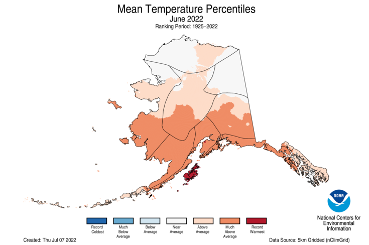
The Alaska statewide June temperature was 52.2°F, 3.0°F above the long-term average. This ranked as the ninth-warmest June in the 98-year period of record for the state. Temperatures were above average across much of the southern half of the state with record warm temperatures across Kodiak Island. Temperatures were near average across much of the North Slope and Northeast Interior divisions. Sitka had its warmest June on record while Anchorage and Kodiak were second warmest. For the first time on record, Anchorage reported daily high temperatures of at least 60°F every day during June.
Credit: NOAA
The year-to-date temperature for Alaska was 24.4°F, 3.0°F above the long-term average, ranking in the warmest third of the record for the state. Above-average temperatures were observed across most of the state and were near average across much of the North Slope and Northeast Interior divisions.
Precipitation
Credit: NOAA
The Pacific Northwest received above average precipitation in June associated with multiple atmospheric river events during the first half of the month and the Southwest received an abundance of precipitation associated with the return of the monsoon season during the second half of June. New Mexico ranked fifth wettest on record. Washington and Oregon ranked seventh and eighth wettest on record, respectively. A dominant ridge of high pressure across the central and eastern U.S. resulted in below-average precipitation totals for the month. North Carolina ranked second driest on record for June and Nebraska seventh driest.
The January-June precipitation total for the contiguous U.S. was 13.84 inches, 1.47 inches below average, ranking in the driest third of the record. Precipitation was above average across portions of the Pacific Northwest, northern Plains, Great Lakes and in pockets from the mid-Mississippi Valley to the Northeast. Precipitation was below average across much of the West and Deep South, as well as portions of the central Plains and Southeast during the January-June period. California ranked driest on record while Nevada and Utah ranked second and third driest for this six-month period, respectively. Texas ranked sixth driest.
Alaska precipitation was near average across the North Slope and portions of the Panhandle, but was generally dry to record dry across much of the state in June. Talkeetna had its lowest June precipitation total since at least 1932. Over the most recent three-month period (April-June), Alaska was also record dry as precipitation averaged across the state was 0.68 inch lower than what was received during the same period in 1954 — shattering that record.
Despite the record-dry conditions of the last three months across Alaska, precipitation averaged across the state for the January-June period ranked in the wettest third of the record and was generally above average across much of southeastern Alaska and near or below average for much of the rest of the state.
Other Notable Events
As of July 1, the largest fire on record in New Mexico, the Hermits Peak Fire, had consumed nearly 342,000 acres and was 93 percent contained. The Black Fire, New Mexico’s second-largest wildfire on record, burned through 325,000 acres and was 70 percent contained as of July 2.
1 million acres burned in Alaska by June 18 — the earliest such occurrence in a year than anytime in the last 32 years. By July 1, 1.85 million acres had been consumed — the second-highest June total on record and the seventh-highest acreage burned for any calendar month on record for Alaska.
The East Fork wildfire in the Yukon River delta region of Alaska is the largest tundra fire on record (since the 1940s) in the Yukon delta at 166,000 acres. Smoke from the ongoing fires created visibility and health concerns across much of mainland Alaska during June.
The elevation of Lake Mead, the nation’s largest reservoir, neared the dead pool, the elevation that prevents the water from flowing downstream from the dam, in late June. On June 30, the lake elevation was 1,043.02 feet above sea level — the lowest elevation since the 1930s when the lake was first filled.
Drought
According to the June 28 U.S. Drought Monitor report, 47.7 percent of the contiguous U.S. was in drought, down about 1.5 percentage points from the end of May, but up 2.4 percent in the last week of June. Drought intensified and/or expanded across the Deep South, Southeast and New England and erupted across portions of the mid-Mississippi and Ohio Valleys. Monsoon rains helped to lessen the drought intensity across parts of the Southwest. Several atmospheric river events aided drought reduction and/or elimination in portions of the Pacific Northwest and the northern Rockies. Drought expanded across Alaska and Puerto Rico and contracted across the Big Island of Hawaii during June.
Billion-Dollar Weather and Climate Disasters
Credit: NOAA
The nine individual billion-dollar events of 2022 include: three general severe weather events, two tornado outbreaks, two hail storms, a derecho event and a broad-area drought event. For this year-to-date period, the 2022 disaster count ranks fifth-highest behind 2017, 2020, 2011 and 2021.
Despite the above-average number of disasters during the first half of 2022, only a small number of fatalities has been reported associated with these events.
With an estimated cost of $2.2 billion, the costliest event to-date was the Southern Severe Weather event that occurred April 11-13.
Since these billion-dollar disaster records began in 1980, the U.S. has sustained 332 separate weather and climate disasters where overall damages/costs reached or exceeded $1 billion (based on the CPI adjustment to 2022) per event. The total cost of these 332 events exceeds $2.275 trillion.
Monthly Outlook
According to the June 30 One-Month Outlook from the Climate Prediction Center, above-normal temperatures are likely across the central and southern Plains and leaning above-normal from the Rockies to the East Coast as well as across southeastern Alaska. Below-normal temperatures are favored along the Pacific Northwest coast. Parts of the Southwest and from the Gulf Coast to the mid-Atlantic coast as well as the western half of Alaska have the greatest chance of above-normal precipitation whereas below-normal precipitation is favored across portions of the Great Basin and the central and southern Plains. Drought is likely to persist over much of the West with some improvement expected across the Southwest and along the west-central Gulf Coast. Drought development is likely from the Lower Mississippi Valley to the Midwest. Outside of the contiguous U.S., drought is likely to persist or develop across portions of Alaska, Hawaii and Puerto Rico, although recent heavy rains may mitigate drought on the eastern portion of Puerto Rico.
According to the One-Month Outlook issued on July 1 from the National Interagency Fire Center, parts of Alaska and Hawaii, eastern Washington to central California, portions of the southern Plains and the east-central Florida coast to the Carolina coast have above normal significant wildland fire potential during July.
Dense stands of Douglas-fir surround South Twin Lake in the Klamath bioregion of northwestern California. Sources/Usage: Public Domain.
Click the link to read the article on the USGS website (Clarke Knight):
A team of federal scientists, academics, and Tribal members recently collaborated on a study that demonstrated the strong influence of Indigenous stewardship on forest conditions in northern California for at least a millennium. Indigenous burning practices coupled with lightning-induced fires kept forest carbon low, at approximately half of what it is today, and kept forests more open and less dense. Forest management and intentional ignitions also resulted in low forest fuel levels that allowed local Indigenous people to produce food and basketry materials, clear trails, reduce pests, and support ceremonial practices for generations.
These stable forest conditions appear to have enhanced the resiliency and health of the fire-prone forests of northern California. However, colonization and twentieth century fire suppression policies have transformed California forests. Forests today are denser and more prone to catastrophic large wildfire than in the past. As restoration ecologists attempt to improve the health of California forests, a key question becomes – restoration to what?
The research team merged multiple lines of evidence from the Klamath Mountains in northern California to help answer this question. They integrated Karuk and Yurok oral histories, Indigenous Traditional Ecological Knowledge (ITEK), a pollen-based vegetation abundance reconstruction, fire scars from tree stumps, a paleofire (past fires that occurred before instrumental record keeping) reconstruction based on sedimentary charcoal, and historic forest inventory data. The evidence was consistent with human management actions on the forest, particularly Indigenous ignitions that kept forest fuels low. Data also show that the current landscape – a dense Douglas fir–dominant forest – is unlike any seen in the preceding 3,000 years.
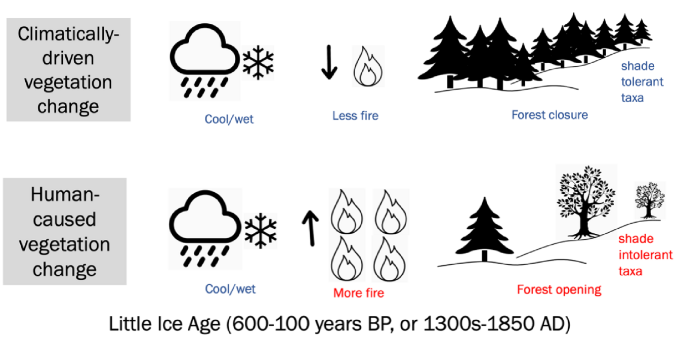
Figure 1. Idealized vegetation response to climate vs. human activity. Top panel shows climatically-driven vegetation change without the influence of people. Bottom panel shows human-caused vegetation change where increases in fire use create more open forest conditions despite cooler/wetter conditions, such as during the Little Ice Age. Credit: Clarke Knight, USGS.
Climate is often presumed to be the most important control on vegetation dynamics during the pre-colonial period, not people. Periods of wetter and colder conditions often lead to less fire on a landscape, the promotion of more shade-tolerant taxa, and more forest closure (Figure 1, top panel). The authors tested the expected effects of climate on northern California forest conditions and found that climate alone could not account for the trends in their data. For example, during the Little Ice Age – a period of cooler and wetter conditions between 1300-1850AD (600-100 years before present) – the authors found a signal of increased fire and vegetation openness (Figure 1, bottom panel), which they corroborated statistically (Figure 2), indicating human involvement in controlling and shaping the forest environment.
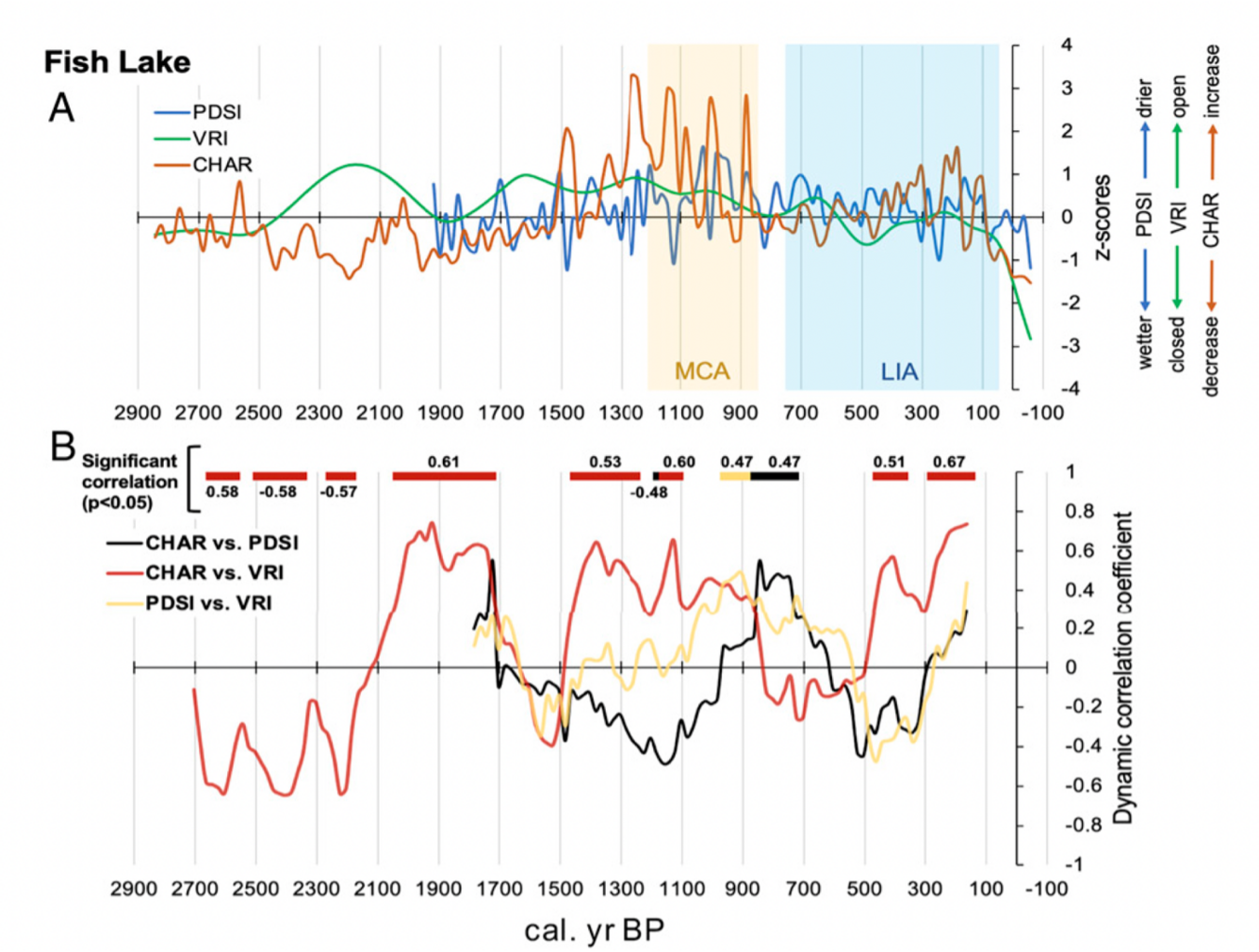
A) Trends in charcoal accumulation (CHAR, a measure of paleofire), Palmer Drought Severity Index (PDSI, a measure of climatic conditions), and vegetation response index (VRI, a measure of forest openness) were plotted through time at Fish Lake, one of two study sites. The Little Ice Age (LIA, blue panel) and Medieval Climate Anomaly (MCA, yellow panel) indicate two time periods of known climatic changes. For example, during the MCA when climate was relatively warmer and drier, CHAR (orange line) increased, in part because forest fuels were drier and easier to burn. B) Trends in correlations between CHAR, PDSI, and VRI over time. There is a significant positive correlation between CHAR and VRI (red line) during the climatically cooler period of the Little Ice Age (600-100 years before present) as predicted by the author’s conceptual model that accounts for human-caused vegetation change through burning practices. Other correlations were found at various times throughout the record. For example, there was a significant positive correlation between CHAR and PDSI around 800 years before present. Modified from Figure 4 in (Knight et al. 2022). Sources/Usage: Public Domain.
This research quantifies what stable, historic forests in California looked like and shows that frequent fire, in part ignited by people, limited forest fuels and shaped the forest for millennia. This finding is important because California is planning to use forest ecosystems to store carbon as part of climate mitigation efforts. The results of this study suggest a large-scale intervention could be required to achieve the historical conditions that supported forest resiliency and reflected Indigenous influence.
Brad Udall: Here’s the latest version of my 4-Panel plot thru Water Year (Oct-Sep) of 2021 of the Colorado River big reservoirs, natural flows, precipitation, and temperature. Data (PRISM) goes back or 1906 (or 1935 for reservoirs.) This updates previous work with @GreatLakesPeck.
From email from the Getches-Wilkinson Center:
This year marked the 42nd Annual Conference on Natural Resources at Colorado Law. Over its rich history, the conference has addressed many different natural resource issues. In more recent years, the Center’s summer conference has explored the major issues in water law and policy in the West.
There is no debate – demands for water across the Colorado River Basin exceed the shrinking supply. Chronic drought, record heat, increasing winds and aridity, as well as rampant wildfires are diminishing the Basin’s overall health and resilience.The historically low levels in Lake Mead and Lake Powell have invited unprecedented federal action and raise the specter of a looming energy crisis. To ensure a sustainable future, these harsh realities will require inclusive collaborations and innovative actions. The return of the GWC Summer Conference brought together a broad array of expertise and diverse perspectives from across the region to candidly discuss these complex challenges. Throughout this conference we examined potential options to advance sustainable water management, expand basin-wide conservation in every sector, and strengthen watershed resilience.
Conference Sessions:
Thursday, June 16: Where We Currently Stand in the Colorado River Basin
The Science: What Does the Climate Science Suggest for the Short- and Long-Term?
The Status, Scope and Timeline of Ongoing Negotiations for the 2026 Guidelines.
Institutional Uncertainty: 100 Years Later, What We Still Don’t Know About the Compact.
The Good (13 MAF/year), the Bad (11 MAF/year), and the Ugly (9 MAF/year). How does the Law of the River work (or not) along this continuum?
Friday, June 17: Building Pathways to a Sustainable Future for All
Crafting a Rural-Tribal-Urban Social Compact in a Warming World.
Water Resiliency Across the System.
Next Generation Voices.
42nd Annual Colorado Law Conference on Natural Resources
Thursday, June 16 and Friday, June 17, 2022
Wolf Law Building, Wittemyer Courtroom
Crystal River rancher Bill Fales stands at the headgate for the Helms Ditch, with Mount Sopris in the background. As part of an agreement with the Colorado Water Trust, Fales could be paid to reduce his diversions from the ditch when the river is low. CREDIT: HEATHER SACKETT/ASPEN JOURNALISM
A Crystal River Valley rancher and a nonprofit organization are teaming up for the second time to try to leave more water in a parched stream.
Cold Mountain Ranch owners Bill Fales and Marj Perry have inked a six-year deal with the Colorado Water Trust to voluntarily retime their irrigation practices to leave water in the Crystal River during the late summer and early fall, when the river often needs it the most. In addition to a $5,000 signing bonus, the ranchers will be paid $250 a day up to 20 days, for each cubic foot per second they don’t divert, for a maximum payment of $30,000.
The water would come from reducing diversions from the Helms Ditch and could result in up to an additional 6 cfs in the river. The agreement would become active in the months of August and September any time streamflows dip below 40 cfs and once becoming active, will extend through October. The agreement will lift if streamflows rise above 55 cfs.
The goal of the program is to use voluntary, market-based approaches to encourage agricultural water users — who often own the biggest and most senior water rights — to put water back into Colorado’s rivers during critical times.
The program has the hallmarks of demand management, a much-discussed concept over the past few years at the state level: it’s temporary, voluntary and compensated. Other pilot programs that focus on agricultural water conservation usually involve full or split-season fallowing of fields, but with this agreement Fales still intends to get his usual two cuttings of hay.
“The idea is to find something that is a flexible way for water rights owners to use their water in years where it makes sense for something different than strictly agricultural practices,” said Alyson Meyer-Gould, director of policy with the Colorado Water Trust. “It’s another way to use their water portfolio.”
Today, Colorado Governor Jared Polis urged the Colorado Department of Public Health and Environment (CDPHE) and other state agencies to take additional steps to improve air quality for Coloradans.
In a letter to key leaders within his administration at the agency level, the Governor wrote: “Clean air is critical to the Colorado way of life. We value protecting our environment, ensuring environmental justice, and promoting better health for all Coloradans. This past legislative session we made substantial progress toward improving our air, including:
Wildfire smoke and ozone have been a daily blur for long range views along the Front Range this summer [2021]. Photo credit: Chase Woodruff/Colorado Newsline
A significant investment over three years to increase resources available to our Air Pollution Control Division (APCD) to right size and modernize the Division. Recent expansion in core responsibilities specifically related to the EPA Ozone non-attainment did not come with adequate resources. These investments now empower the Division to expand monitoring and emissions work, accelerate the transition to cleaner technologies across various industries, and to more thoroughly engage with communities across the state, particularly those most affected by air pollution.
West Grand School District electric school bus. Photo credit: The Mountain Town News/Allen Best
Hundreds of millions of dollars of state money to clean up our transportation system, including resources to position Colorado as a national leader in the electrification of our school bus fleet; substantial resources to decarbonize the industrial and aviation sectors above and beyond current and future greenhouse gas emissions rules; saving people money on transit with free and reduced-cost fares, and significant investments to reduce pollution from the buildings sector.
New plating at the Glenwood Springs water intake on Grizzly Creek was installed by the city to protect the system’s valve controls and screen before next spring’s [2021] snowmelt scours the Grizzly Creek burn zone and potentially clogs the creek with debris. (Provided by the City of Glenwood Springs)
Expanded capabilities across the State to mitigate, prepare for, and respond to disasters such as wildfires, mudslides and flooding and other devastating impacts of climate change.”
The Governor acknowledged that CDPHE and the Air Quality Control Commission have an ambitious agenda over the next 12 months to establish new plans, and standards to improve air quality, reduce greenhouse gas pollution, and reduce paperwork for Colorado businesses.
The Governor also urged CDPHE and the Colorado Oil and Gas Conservation Commission (COGCC) to take steps to improve air permit modeling, the permitting process, and oil and gas emissions reporting, evaluate cumulative impacts, reduce emissions from heavy duty off-road engines, improve collaboration between COGCC and APCD, and provide greater access to air quality information for the public.