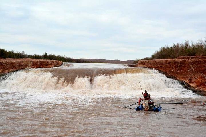
Since the late 1980’s, this waterfall formed from interactions among Lake Powell reservoir levels and sedimentation that redirected the San Juan River over a 20-foot high sandstone ledge. Until recently, little was known about its effect on two endangered fishes. Between 2015-2017, more than 1,000 razorback sucker and dozens of Colorado pikeminnow were detected downstream of the waterfall. Credit: Bureau of Reclamation
From email from Reclamation (Susan Novak Behery):
In response to continued forecast precipitation, the Bureau of Reclamation has scheduled a decrease in the release from Navajo Dam from 800 cubic feet per second (cfs) to 600 cfs for today, July 26th, at 4:00 PM.
Releases are made for the authorized purposes of the Navajo Unit, and to attempt to maintain a target base flow through the endangered fish critical habitat reach of the San Juan River (Farmington to Lake Powell). The San Juan River Basin Recovery Implementation Program recommends a target base flow of between 500 cfs and 1,000 cfs through the critical habitat area. The target base flow is calculated as the weekly average of gaged flows throughout the critical habitat area from Farmington to Lake Powell.
Hmmm. I found a recent letter to Midwesterners published rather insulting. I think the West needs to solve its own problems without making problems for other regions at a huge cost. Who is going to pay for the water transfer anyway? Certainly, Midwesterners don’t want to. A few suggestions for Western states:
Stop building golf courses that use tons of water and get rid of most of them.
Stop planting grass and plants that don’t belong in a desert and watering them day and night to grow
Replace water parks with something that fits into a desert area
Stop developers from building more homes and promising 100 years of water usage. Obviously, you are running out much sooner. City planners are not doing a good job about growth and water management in a region that was way overbuilt 20 years ago.
Reduce the asphalt and concrete poured to make roads and parking lots. No trees or greenery certainly doesn’t keep things cooler.
Click the link to read the post on the InkStain.net website (John Fleck, Eric Kuhn, and Jack Schmidt):
As stakeholders negotiate the current crisis on the Colorado River, we believe the representatives of the states of the Upper Basin – our states – are making a dangerous argument.
Their premise is simple. With deep cutbacks needed, the Upper Basin states argue that their part of the watershed already routinely suffers water supply shortages in dry years. Without the luxury of large reservoir storage along the rim of the watershed that might store excess runoff in wet years and supplement supplies in dry years, the argument goes, the Upper Basin is limited by the actual mountain snowpack in any given year.
This is certainly true in many places. One of us (Fleck) lives in a community (Albuquerque, New Mexico) that has routinely seen supplies of trans-basin San Juan-Chama Project water shorted because of bad hydrology in a given year.
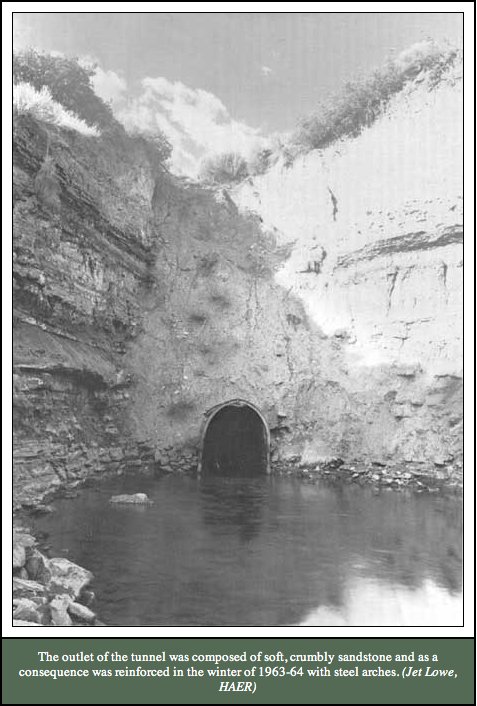
Montezuma Tunnel steel arches.
That is also the case for the oft-cited Dolores Water Conservancy District, which has junior water rights to the supply provided by McPhee Reservoir that is part of the Bureau of Reclamation’s Dolores Project. In contrast, the adjacent Montezuma Valley Irrigation Company has pre-Colorado River Compact water rights and its access to the same water source is relatively unlimited. The argument of the Upper Basin states about using less water in dry times applies in many local settings, especially in the local context of prior appropriation water rights. The argument is certainly logical.
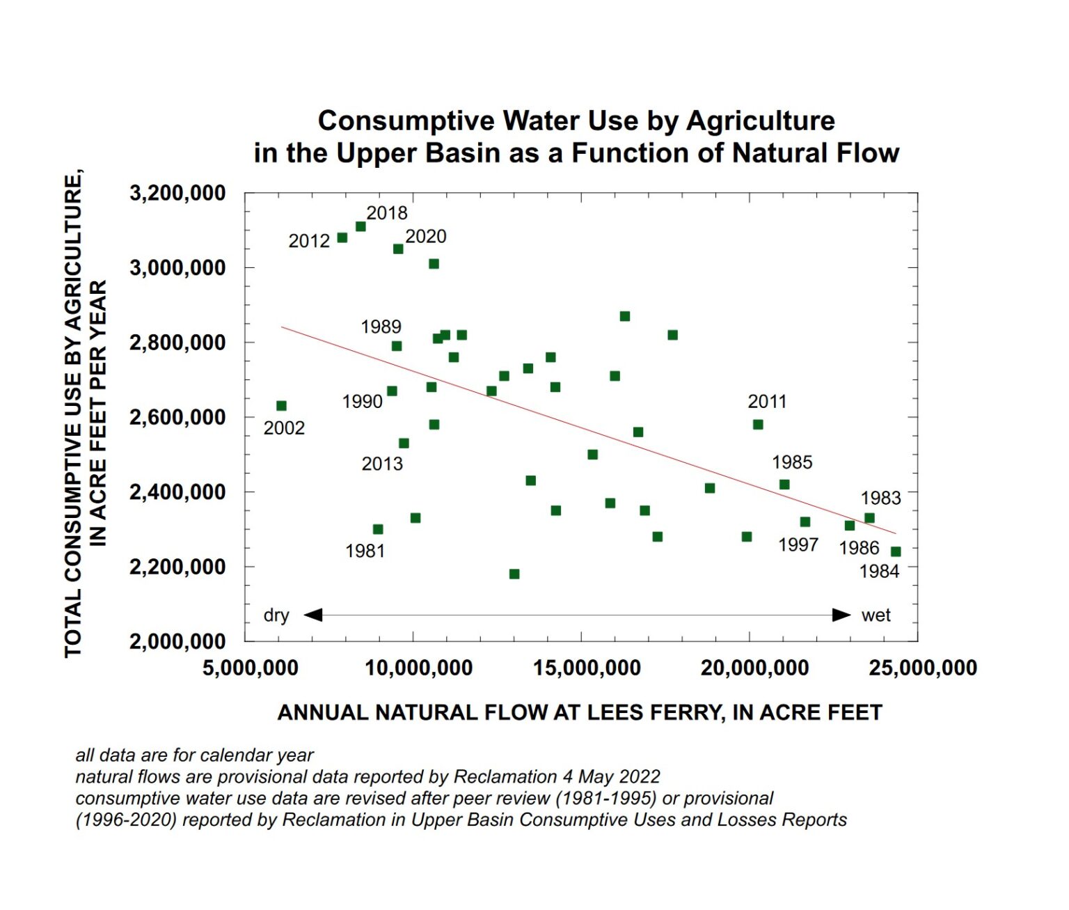
Upper Colorado River Basin agricultural water use in wetter and drier years. Graph by Jack Schmidt, Utah State University
Importantly, a scatter plot of Upper Basin agricultural water use since 1981 shows, in general, the opposite of what is being claimed. While agricultural use varies greatly from to year, in general, use has been greater in dry years and less in wet years.
In this plot, the estimated natural flow at Lees Ferry (a good representation of whether any individual year was wet or dry) is plotted against the summed agricultural use of water by all of the Upper Basin states. This simple analysis provides results counter to the assertion of the Upper Colorado River Commission in the sense that agricultural use of water was greater in years of low natural flow at Lees Ferry and was less in years of high natural flow at Lees Ferry. Thus, this simple relationship indicates that agriculture uses less water in wet years and more water in dry years, which is exactly the opposite of the assertion by the Upper Basin community.
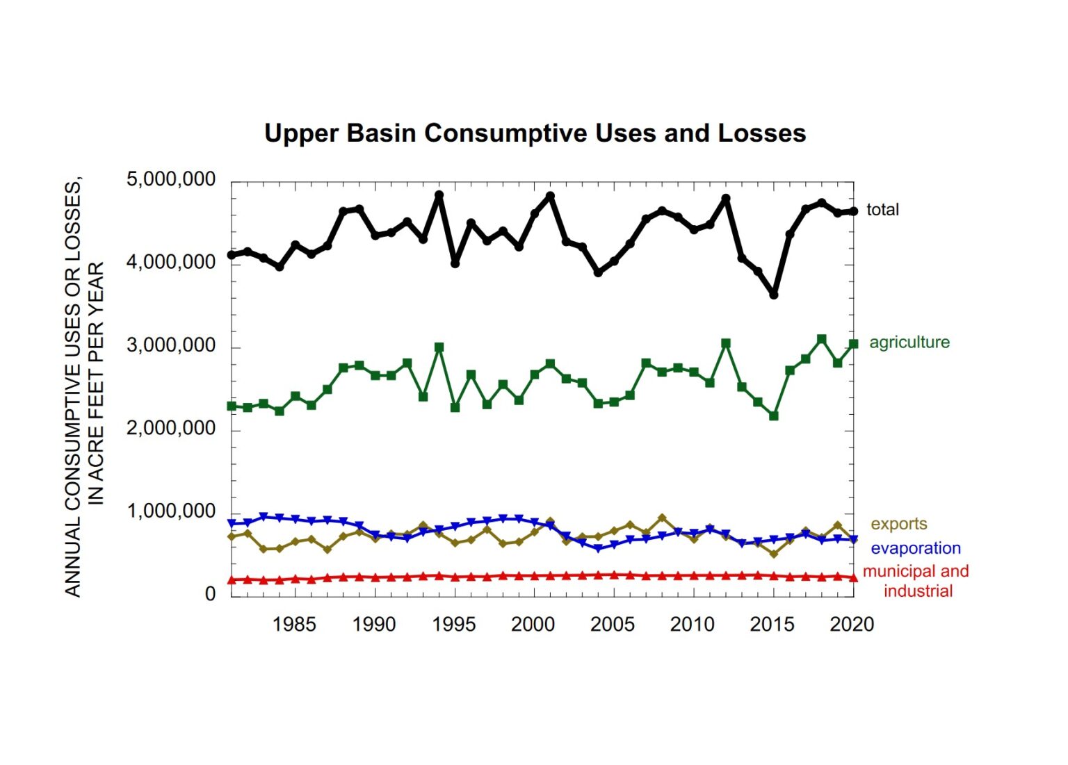
Upper Colorado River Basin water use over time. Graph by Jack Schmidt, Utah State University, based on USBR Consumptive Uses and Losses Reports
Another way of looking at this question is to consider the long term temporal trend. If the Upper Basin’s argument was correct, we would see a decline in agricultural water use in the 21st century, because the river’s flow shrank during the aridification of the 21st century. However, use has not decreased.
There are important nuances in the data. In the second year of some consecutive dry years like 2012-2013, the Upper Basin’s total consumptive use drops significantly, perhaps because local storage is depleted in the first year and doesn’t fully refill in the second year. This may be the situation in 2020-2021 as well.
Why do we view the argument as dangerous? Because Lower Basin interests can do the same math we have. They almost certainly already have. That leaves the Upper Basin with a fragile foundation for entering the negotiations over the compromises that are certain to be needed to modify the Colorado River’s allocation rules in the face of climate change.
Authors:
John Fleck is Writer in Residence at the Utton Transboundary Resources Center, University of New Mexico School of Law
Eric Kuhn is retired general manager of the Colorado River Water Conservation District based in Glenwood Springs, Colorado, and spent 37 years on the Engineering Committee of the Upper Colorado River Commission
Jack Schmidt is Professor of Watershed Sciences and director of the Future of the Colorado River Project at Utah State University
“The water ditch is the basin of civilization” — Greg Hobbs.
Annette Choszczyk lives in rural western Colorado these days, but when she was a kid, the Highline Canal in Denver was her summer paradise.
“To us, it was river and a playground, complete with rope swings, swimming holes, crawdads and a trail alongside it that adults and kids could walk on to the foothills or far out into the prairie.” They always called it a ditch, this 71-mile-long canal that carried water all over Denver.
Throughout the West, thousands of ditches that snake for miles through semi-arid country are nothing less than beloved. They add living green corridors to walk or bike along, impromptu wetlands frequented by birds, and always, a respite from summer heat.
But now a warming climate delivers less melted snow to rivers that supply these diversion ditches with water. Federal legislation also mandates piping many earthen ditches to cut salinity in the Colorado River water that’s sent to Mexico.
The result: Dry trails, disappearing wetlands and the end of a rural and urban amenity.
Many people mourn the loss. “With less water we have to figure out how to try to retain the best of what we value the most,” says John Fleck, a water researcher at the University of New Mexico’s Utton Center. He says the Griego Lateral, in Albuquerque, that he regularly bikes along, was built in 1708, and during the COVID lockdown, the ditch bank was mobbed with bikers and walkers desperate to get outdoors. “There is incredible value in these ditches,” he says.
But Fleck points out that we’re confronted by difficult choices: “How much water do we keep in rivers and which ditches do we save?” Any loss can be painful, and in a blog post, Fleck said simply: “I love living near a ditch.”
You could say of Cary Denison, former project coordinator for Trout Unlimited and an irrigator, that he was born in irrigation boots. “In western Colorado, my dad was the superintendent of the Fire Mountain Canal,” he says, “and my first job was irrigating.” These days, though, Denison thinks rivers get shortchanged because too much water gets diverted into ditches.
“Then a river suffers,” he says. “We need to maintain enough water in the river for fish and plant life.”
Dennison recalls a startling moment as he irrigated family property outside of Hotchkiss, Co. The gated 12-inch pipe was clogged, so he and his brother began cleaning it out, expecting a mass of leaves and twigs. But the clog turned out to be the biggest brown trout — “and I fished almost daily,” he says — that he’d ever seen. That fish had come a long way. Their property was nine miles from the diversion where the river was sweeping almost entirely into the ditch.
These days Dennison is an irrigator himself and lives in the town of Ridgway. But he recalls that giant brown trout as “a day where irrigators should have taken less.” The experience led Denison toward his work in conservation: “We need to take only the water from rivers we absolutely need.”
Photo credit: Jonathan Thompson
Fleck and other students of the Colorado River see a time coming soon when many water diversions will cease because of their lower priority dates. Some ditches are already dry, as the water gets left in the river for the Lower Basin states of Arizona, Nevada and California. These states share the river equally with the Upper Basin states of Colorado, Utah, New Mexico and Wyoming, where the river begins and gathers strength.
Over centuries, says Fleck, “one of the things that we’ve done in all these Western landscapes is to narrow the river itself with levees and dams and control it in a narrow channel. And we’ve distributed water across the floodplain through ditches. It’s this huge rich, complex social and cultural ecosystem that we’ve all lived in for hundreds of years.”
But increasing aridity is already changing that pattern. Earlier this summer, Choszczyk, who now lives in western Colorado, mourned the loss of some of her local ditches as they got piped, ending the riparian ribbon that enhanced her neighborhood.
“Generations of children will have poorer childhoods because they will never have a ‘wild’ place along a ditch to explore,” she says.
It’s hard to love a semi-desert once you’ve come to appreciate the wonders that a ditch can bring.
Dave Marston is publisher of Writers on the Range, writersontherange.org, an independent nonprofit dedicated to lively discussion about the West.
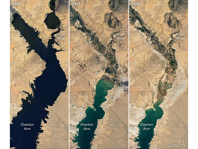
Images from the NASA Earth Observatory released in early July focused on the northern arm of Lake Mead and its decline from 2000 until now. As western states are being asked for solutions to keep Lake Mead and Lake Powell from hitting critical low points, there is more talk about what it would take to pump water from the Mississippi River to western states as well. (Image courtesy of NASA Earth Observatory)
Click the link to read the post on the Progressive Farmer website (Chis Clayton). Click through to the links. Here’s an excerpt:
With the long-term drought, or essentially the change in climate, and steady decline of water supplies on the Colorado River, residents in states such as California are increasingly suggesting why can’t we pipe water to western dams much like we pipe oil now? This isn’t a new debate, but it’s a topic that’s going to come up more and more as water levels at Lake Mead and Lake Powell continue to shrink.
This past weekend I received an email about an editorial in the Waterways Journal, “Drought Revives Mississippi River Pipe Dreams.” The editorial noted the debate going on through columns and letters to the editor in the Palm Springs, Calif., newspaper over the possibility of piping water from the Mississippi River to Lake Powell in northern Arizona.
Looking at nothing more than Google Maps, getting water the Mississippi River to Lake Powell is 1,459-mile journey from Baton Rouge, La.
Debate is heightening as states in the Colorado River are proposing cuts in water use for next year to keep Powell and Mead from reaching critically low levels — points at which the Glen Canyon Dam could stop generating hydropower.
Created by Imgur user Fejetlenfej , a geographer and GIS analyst with a ‘lifelong passion for beautiful maps,’ it highlights the massive expanse of river basins across the country – in particular, those which feed the Mississippi River, in pink.