In response to continued forecast precipitation, the Bureau of Reclamation has scheduled a decrease in the release from Navajo Dam from 600 cubic feet per second (cfs) to 500 cfs for today, July 27th, at 4:00 PM.
Releases are made for the authorized purposes of the Navajo Unit, and to attempt to maintain a target base flow through the endangered fish critical habitat reach of the San Juan River (Farmington to Lake Powell). The San Juan River Basin Recovery Implementation Program recommends a target base flow of between 500 cfs and 1,000 cfs through the critical habitat area. The target base flow is calculated as the weekly average of gaged flows throughout the critical habitat area from Farmington to Lake Powell.
This graphic shows the increasing warming influence over time of CO2 and non-CO2 greenhouse gases, in CO2 equivalents, on the left axis. The corresponding increase in the AGGI is shown on the right axis. Credit: NOAA Global Monitoring Laboratory.
According to studies from The Colorado Health Institute and others, our state’s median temperature increased by two degrees Fahrenheit, in just the past 30 years. In response, the Institute enacted “Think globally, Act locally” – a new project that examines climate changes, the impact on Coloradans’ health, and whether the state is prepared to address those health impacts.
Khira Isaacs spoke with officials from the “C-H-I” about a new tool designed to help protect our health — and prevent Colorado from reaching its boiling point.
“We’ve worked on CHI’s Climate and Health portfolio for the better part of the last half decade really making sense of the connection of climate’s impact on the health of Coloradans,” says Senior Policy Analyst, Karam Ahmad.
Ahmad also says climate change can increase the risk of injury, illness and disease, or death. But not all communities or individuals are affected in the same ways — unique circumstances and characteristics all play a role. Currently, Mesa County and other Western Colorado counties rank highest on the list: the five deciding factors being number of extreme heat days, percentage of land with highest wildfire risk, percentage of weeks population experiences drought, percentage of the population who lives in a wildland urban interface and community flooding.
“And when we look at the map right here, looking at our overall risk. We are seeing southern Colorado and southeast Colorado really highlight some of the highest risk. And the reason we are seeing these counties in the category — a lot of it has to do with they have some of the highest rates of poverty in the state. We also saw that they have some of the oldest homes -When it’s very hot out or when there’s poor air quality, our house is where we seek shelter and so an older home is less likely to have insulation or upkept with maintenance and those are very important things when it comes to air quality and the heat,” says Policy Analyst, Chrissy Esposito.
The Health and Climate Index is part of “Acclimate Colorado” — Colorado’s Health Institute’s effort to build capacity, community resilience and an agenda for addressing climate-related health challenges. The tool gives professionals a road map to confront and adapt to environmental and public health threats — it’s a conversation Ahmad says should happen frequently.
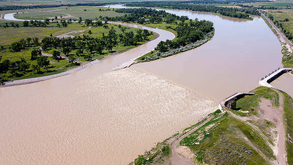
Photo of the Lower Yellowstone Fish Passage Project via USBR.
Click the link to read the release on the Reclamation website (Brittany Jones):
The Bureau of Reclamation will continue its celebration of its 120th Anniversary with a ribbon cutting ceremony for the completion of the Lower Yellowstone Intake Diversion Dam Fish Passage Project on July 26, 2022. The U.S. Army Corps of Engineers will co-host the ribbon cutting ceremony located on Joe’s Island near Glendive, Montana.
The U.S. Department of the Interior’s Assistant Secretary for Water and Science Tanya Trujillo, the Bureau of Reclamation’s Commissioner Camille Calimlim Touton, U.S. Army Corps of Engineer’s Northwestern Division Commander Colonel Geoff Van Epps and the Omaha District Commander Colonel Mark Himes will attend the ceremony to commemorate Reclamation’s 120th year of providing water to the West and to celebrate the success of this, three-year, $44 million fish bypass construction project. The success of the project is due, in part, to the joint efforts and contributions of the U.S. Army Corps of Engineers and Bureau of Reclamation to improve the fish passage structure for the endangered pallid sturgeon and other native species around the Lower Yellowstone Intake Diversion Dam.
Construction on the fish bypass channel began in April 2019 and was completed with the removal of the cofferdam on April 9, 2022. The 2.1-mile-long channel was constructed as part of the Lower Yellowstone Intake Diversion Dam Fish Passage Project that was designed to address fish passage concerns associated with the diversion dam.
President Biden’s Bipartisan Infrastructure Law makes a $200 million investment in the National Fish Passage Program over the next five years to conserve fish habitat and advance projects like this one.
“We are excited to celebrate the success of this interagency project and recognize Reclamation’s major contributions to reclaiming America’s 17 Western states over the last 120 years,” said Brent Esplin, Missouri Basin and Arkansas-Rio Grande-Texas Regional Director. “In addition to bolstering conservation efforts of the prehistoric pallid sturgeon, Reclamation is committed to continuing the effective operation of the Lower Yellowstone Project for local irrigators who help feed the nation.”
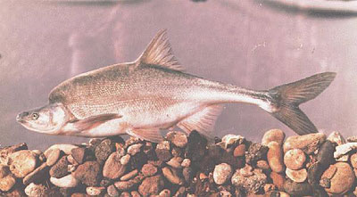
Pallid sturgeon
In 1990, the pallid sturgeon was listed as endangered by the U.S. Fish and Wildlife Service under the Endangered Species Act. The U.S. Army Corps of Engineers, the U.S. Fish and Wildlife Service, and the Bureau of Reclamation worked in partnership to determine the effects of the Lower Yellowstone Project on the endangered species. Two primary issues were identified; fish entrainment into the Lower Yellowstone Irrigation District’s main irrigation canal and fish not being able to successfully pass over the Intake Diversion Dam to upstream spawning reaches. A new screened canal headworks structure was completed in 2012 that addressed the fish entrainment issue. The new weir in conjunction with the completed fish bypass channel will provide passage for the endangered fish and open approximately 165 river miles of potential spawning and larval drift habitat in the Yellowstone River.
While this portion of the project is complete, construction in the area is ongoing. The contractor, Ames Construction Inc., is still actively working on Joe’s Island to restore construction roads back to natural vegetation. The contractor will rehabilitate sections of Road 551, located off State Highway 16, and Canal Road, both on the north side of the Yellowstone River at Intake, Montana. Joe’s Island is expected to remain closed through the Fall of 2022 when all construction related activities will be complete.
“This is a momentous occasion more than ten years in the making,” said Col. Geoff Van Epps, commander of the U.S. Army Corps of Engineers, Northwestern Division. “The collaboration on this project presented unique challenges and opportunities to meet conservation and recovery responsibilities under the Endangered Species Act while continuing to serve the needs of stakeholders that use the river. The professionalism and mutual respect of all involved provided a healthy, dynamic work climate in which to operate to achieve common goals and objectives.”
The Lower Yellowstone Project is a 58,000-acre irrigation project located in eastern Montana and western North Dakota. The project is operated and maintained by the Lower Yellowstone Irrigation District Board of Control under contract with Reclamation. The project includes the intake diversion dam, a screened headworks structure, 71 miles of main canal, 225 miles of laterals and 118 miles of drains, three pumping plants on the main canal, four supplemental pumps on the Yellowstone River and one supplemental pump on the Missouri River.
Media representatives interested in attending the ceremony should RSVP to Brittany Jones at (406) 247-7611 or bjones@usbr.gov, no later than Friday, July 22. For media unable to attend, photos, videos and a news release will be available following the ceremony.
Click the link to read the guest column on the North Forty News website (Blaine Howerton). Here’s an excerpt:
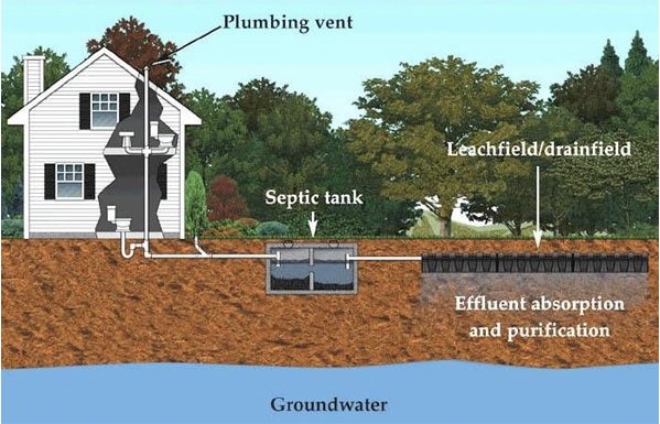
Larimer County’s rules for selling a property with a septic system have been in place for one year now but few are aware of the new requirements. While it has always been customary for a seller to have the septic system pumped and inspected prior to closing, now it is mandatory. Why the change? The county is trying to protect buyers and uncover unhealthy systems. According to Larimer County’s website, Colorado counties operating similar programs found repairs were needed in approximately 20% of septic systems that were inspected.
A seller must use a Larimer County certified 3rd party inspector to pump and inspect the septic. If the system is in good working order, the inspector will submit documentation to Larimer County for review. A seller must then obtain an Acceptance Document from Larimer County and provide this to the buyer.
If the system fails, the seller must repair it. If the seller is unable or unwilling to repair the system, the buyer accepts responsibility and must obtain a permit and repair the system within 180 days of purchase.
We have seen the cost of inspections under this new system double. Prior to implementation, the cost for a septic pump and inspection was around $350 – $400. Now sellers are paying between $750 – $850 for the extra effort of providing documentation to the county.
Need more details? Visit http://www.larimer.org and enter Septic System Transfer of Title.
Aerial view of irrigated and non-irrigated fields in eastern Colorado. Photo by Bill Cotton, Colorado State University
Click the link to read the release on the USDA website (Margaret Lawrence):
Rapidly dropping reservoir levels in the West are capturing national media attention, but the nation’s underground aquifers are also under threat.
The Ogallala aquifer is one of the world’s largest fresh water resources. Communities and agriculture in eight states in the High Plains region of the country rely on it.
Ogallala Aquifer States
Colorado
Kansas
Nebraska
New Mexico
Oklahoma
Texas
South Dakota
Wyoming
Most water pumped from the Ogallala aquifer is used by agriculture, the chief driver of the region’s economy. Decades of pumping from the Ogallala aquifer continue to reduce the groundwater table faster than it can be recharged from precipitation.
Through an Agriculture and Food Research Initiative Water for Agriculture Challenge Area grant, USDA’s National Institute of Food and Agriculture (NIFA) funded a multiyear Coordinated Agriculture Project (CAP) to address the challenges faced by the Ogallala aquifer. NIFA is committed to addressing agricultural water quality and quantity needs even as it works to improve the nation’s surface and groundwater resources via climate-smart agriculture, forestry and renewable energy.
Producers, groundwater management district leaders, researchers, and graduate students met on a regular basis to focus on and share updates about the project team’s work. Photo by Amy Kremen, CSU
“Multiyear, multistate CAP projects like Ogallala Water funded over five years with $10 million in federal dollars allow for the development of partnerships and networks at the regional, state and local levels,” said Kevin Kephart, deputy director of NIFA’s Institute of Bioenergy, Climate and Environment. “This results in greater awareness of the issue and fosters the adoption of practical, profitable approaches to maintain an economy based on agriculture while extending the aquifer’s life.”
The project boasted a 70-member interdisciplinary team from 10 universities in six states.
Jim Dobrowolski, national program leader for NIFA’s Division of Environmental Systems, said Ogallala Water was laser-focused on extending the aquifer’s utility for irrigated agriculture.
“They spent five years working towards a solution to what many people consider the greatest management challenge in the nation today,” he added.
According to Dobrowolski, the project’s partnership with local, state, and federal agencies—including USDA’s Natural Resources Conservation Service (NRCS) and Agricultural Research Service (ARS)— contributed to its overall success.
“Ogallala Water cooperated with USDA-NRCS’s Ogallala Aquifer Initiative and USDA-ARS’s collaborative Ogallala Aquifer Program with Texas A&M University, along with state water agencies, local water and irrigation districts, and farmers,” Dobrowolski said. “The team improved understanding about how to manage water to be successful at achieving voluntary and mandatory water use goals through multidisciplinary field research and outreach programs, as well as by studying farmers decisions and outcomes.”
Colorado State University (CSU) scientist Meagan Schipanski, who served as the project leader, said the Ogallala Water CAP built new collaborations across institutions and disciplines.
Dr. Erin Haacker (Assistant Professor, Earth & Atmospheric Sciences, University of Nebraska-Lincoln) and Dr. Sumit Sharma (Assistant Extension Professor, Oklahoma State University), during their time as postdoctoral researchers on the Ogallala Water team, helping share the project’s research and outreach materials at the 2018 Governor’s Conference on the Future of Water in Kansas in Manhattan, Kansas. Photo by Amy Kremen, CSU.
“Our team made important research discoveries at the individual producer level, regional level and multistate level,” she said. “For example, the group made improvements to freely available irrigation scheduling tools by integrating soil moisture sensors and short-term weather forecast data to improve water use efficiency. At the regional level, the team developed MOD$$AT, a modeling program that can evaluate potential hydrologic and economic impacts of real-world policy and management scenarios.”
In addition to their research efforts, the Ogallala Water CAP team ensured their research reached producers and others through Extension outreach efforts.
The team supported the development of new — and expanded the use of — innovative programs, including Master Irrigator and Testing Ag Performance Solutions (TAPS). These tools are influencing management decisions on hundreds of thousands of acres in the High Plains. A multistate network of Extension professionals was formed to share successes and challenges in groundwater-dependent areas of the High Plains, California, and the Mississippi Delta region. Additionally, two summits led by the team in 2018 and 2021 forged strong diverse stakeholder networks of individuals and groups working across the region that are learning from each other’s success in encouraging improved water management.
Schipanski’s CSU colleague, Amy Kremen, said the team’s work has been critically important to finding ways to address the challenges facing the Ogallala aquifer.
“The Ogallala Water CAP team has identified how water managers in this semi-arid production area can benefit from flexible state policies and access to state and federal programs that reward groundwater stewardship,” said Kremen. “Some possibilities include voluntary collective commitments to limit pumping, new limited irrigation crop insurance options, and programs that help producers prioritize profitability and water use productivity over maximizing yield.”
Schipanski and Kremen agree that commitments from individual producers, as well as state and federal policymakers, are needed to extend the life of the aquifer while supporting agriculture and rural communities in the High Plains.
The Ogallala aquifer, also referred to as the High Plains aquifer. Source: National Oceanic and Atmospheric Adminstration
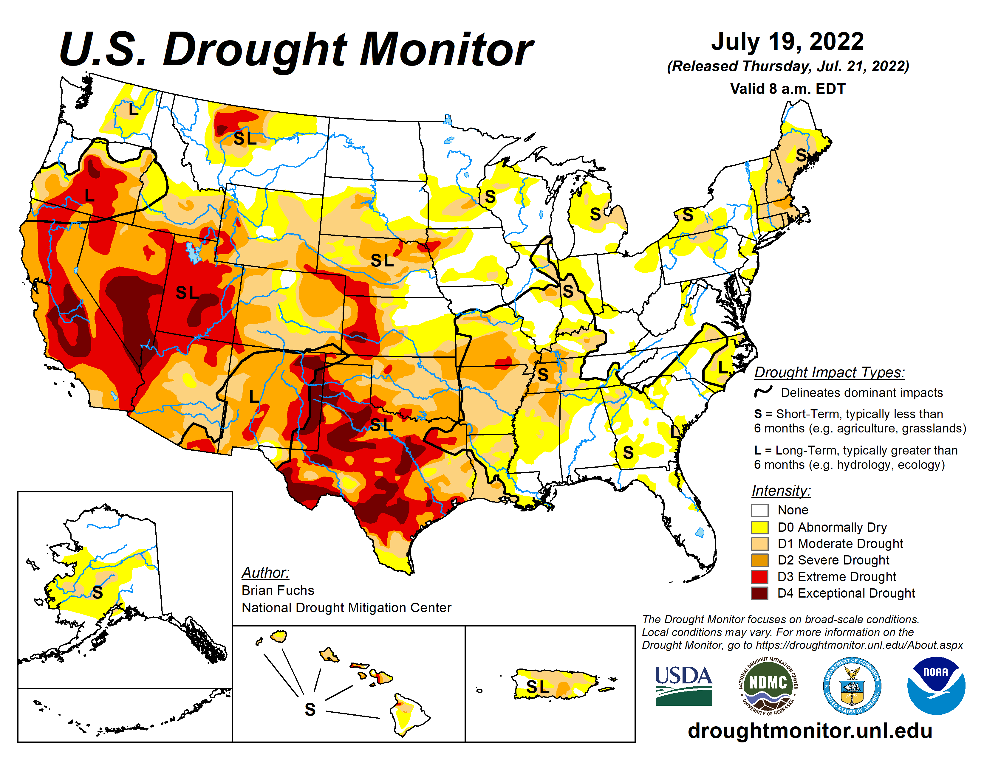
As of July 19, over 44 percent of the U.S. and Puerto Rico is in drought, a nearly 12 percent increase in the last month.
States in the Colorado River’s upper basin respond to the federal government’s call for water conservation.
The Albuquerque stretch of the Rio Grande is drying up for the first time in almost 40 years.
High temperatures and dry conditions are fanning the Oak fire in Mariposa County, California, which has burned more than 16,700 acres.
THE NUMBERS
Nearly 52 percent of the land area in the Lower 48 states is experiencing moderate drought or worse this week. This year continues to be the largest expanse of drought in the country since 2012-13. These conditions are affecting over 119 million people. According to the U.S. Drought Monitor, dry conditions are present across 225 million acres of cropland.
According to the National Weather Service weather prediction center, the epicenter of intense heat will shift from the Northeast to the South-Central U.S. and Pacific Northwest this week. Warmer temperatures can exacerbate drought conditions by causing more evaporation and drying out soils.
Over 94 percent of Texas is experiencing some form of drought, and a fifth of the state is in exceptional drought. Over 22.8 million Texans are affected, including farmers experiencing decreased crop and livestock production. Cities are threatening to fine residents who violate water restrictions. Earlier this month, the North Texas Municipal Water District urged residents to reduce their water use as it had to cease water production at one of its four treatment plants. According to the utility, the system is under stress from drought combined with increased outdoor water use.
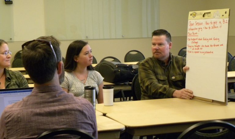
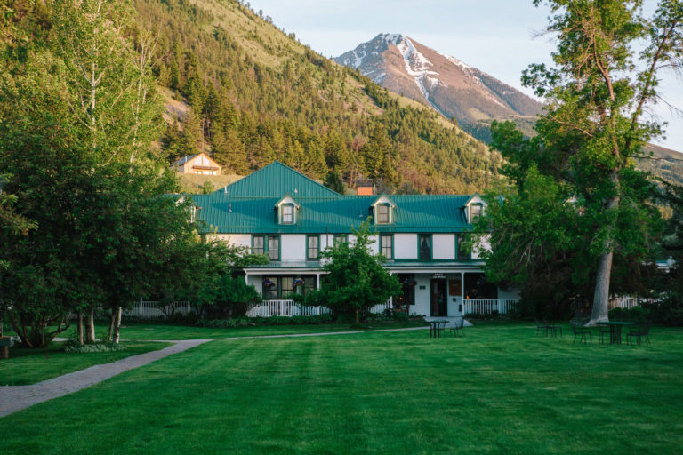
Confluence, an upcoming conference hosted by Colorado State University, will address the interests and needs of collaborative conservation groups in the West and is set to take place Sept. 19-22 at the Chico Hot Springs Resort in Pray, Montana.
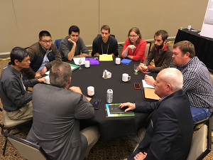
Attendees at the last Confluence in 2020, where 120 participants gathered to learn from their peers, participate in workshops, and network with other collaboratives across the West.
The conference is hosted by the Western Collaborative Conservation Network, an organization housed in the CSU Center for Collaborative Conservation that promotes and supports community-based collaborative conservation efforts to strengthen and sustain healthy landscapes, vibrant communities and thriving economies in the West, including Arizona, Colorado, Idaho, Montana, New Mexico, Nevada, Oregon, Utah, Texas and Wyoming.
The conference will focus on three key collaborative conservation topics: watersheds, regional governance and cross-cultural collaboration.
Online registration closes on Aug. 26 with early-bird registration prices ending on July 31.
Confluence will be held at Chico Hot Springs in scenic Pray, Montana, for three days of intensive learning and connecting with other collaborative conservation practitioners.
Confluence attendees can participate in peer-to-peer learning sessions on measuring collaborative impacts; supporting emerging leadership; storytelling, communications and media; conservation finance; cross-cultural partnerships; and essential skills for a collaborator’s toolbox.
WCCN member Shauni Seccombe, a project manager at the Center for Natural Resources & Environmental Policy at the University of Montana, said the conference’s carefully chosen case studies, workshops, speakers and field trips ensure participants will be engaged in content that is both relatable and relevant to the “vital work that is collaborative conservation in the West,” with applications ranging from the local to national scale.
“With its emphasis on genuine human connection and peer-to-peer learning, Confluence 2022 will bring together various forms of knowledge, experience and understanding with the hope of strengthening our vision and capacity for a more sustainable, collaborative future.”
Along with the peer-to-peer workshops and keynotes, attendees will immerse themselves in the Montana landscape to learn about relevant case studies through field trips and discussion about Montana collaborative conservation efforts. View the summary agenda and content summary for more details about the topics that will be covered during the event.