Air samples from NOAA’s Mauna Loa observatory in Hawaii provide important data for climate scientists around the world. On Thursday, NOAA announced that analysis of data from their global sampling network showed that levels of the potent greenhouse gas methane recorded the largest annual increase ever observed in 2021, while carbon dioxide continued to increase at historically high rates. (NOAA)
Humans pumped 36 billion tons of the planet-warming gas into the atmosphere in 2021, more than in any previous year. It comes from burning oil, gas and coal.
The amount of planet-warming carbon dioxide in the atmosphere broke a record in May, continuing its relentless climb, scientists said Friday. It is now 50 percent higher than the preindustrial average, before humans began the widespread burning of oil, gas and coal in the late 19th century.
There is more carbon dioxide in the atmosphere now than at any time in at least 4 million years, National Oceanic and Atmospheric Administration officials said.
The concentration of the gas reached nearly 421 parts per million in May, the peak for the year, as power plants, vehicles, farms and other sources around the world continued to pump huge amounts of carbon dioxide into the atmosphere. Emissions totaled 36.3 billion tons in 2021, the highest level in history.
As the amount of carbon dioxide increases, the planet keeps warming, with effects like increased flooding, more extreme heat, drought and worsening wildfires that are already being experienced by millions of people worldwide. Average global temperatures are now about 1.1 degrees Celsius, or 2 degrees Fahrenheit, higher than in preindustrial times.
This graphic shows the increasing warming influence over time of CO2 and non-CO2 greenhouse gases, in CO2 equivalents, on the left axis. The corresponding increase in the AGGI is shown on the right axis. Credit: NOAA Global Monitoring Laboratory.
This year marks the 42nd Annual Conference on Natural Resources at Colorado Law. Over its rich history, the conference has addressed many different natural resource issues. In more recent years, the Center’s summer conference has explored the major issues in water law and policy in the West.
There is no debate – demands for water across the Colorado River Basin exceed the shrinking supply. Chronic drought, record heat, increasing winds and aridity, as well as rampant wildfires are diminishing the Basin’s overall health and resilience.The historically low levels in Lake Mead and Lake Powell have invited unprecedented federal action and raise the specter of a looming energy crisis. To ensure a sustainable future, these harsh realities will require inclusive collaborations and innovative actions. We look forward to bringing together a broad array of expertise and diverse perspectives from across the region to candidly discuss these complex challenges. Please add your voice as we examine potential options to advance sustainable water management, expand basin-wide conservation in every sector, and strengthen watershed resilience.
A kayaker runs the 6-foot drop of Slaughterhouse Falls on the Roaring Fork River in June 2021. River recreation and conservation groups are pushing a bill that aims to establish a recreational in-channel values reach designation, which would create a legal mechanism to lease water for river recreation. CREDIT: HEATHER SACKETT/ASPEN JOURNALISM
Colorado Water Conservation Board Seeking Water Success Stories
As part of the larger Colorado Water Plan update process, the Colorado Water Conservation Board has launched a new online portal for members of the public to submit their success stories on how they are building a stronger water future for Colorado. To learn more and submit a story, visit engagecwcb.org. The Colorado Water Plan draft is set for release for public comment on June 30.
Wetter weather patterns have tempered drought conditions in the upper Arkansas Basin and boosted snowpack, but the latest U.S. Drought Monitor report shows Extreme to Exceptional drought (D3-D4) across Baca, Bent and Prowers counties with Extreme drought extending into four adjoining lower-basin counties.
Colorado Drought Monitor map May 31, 2022.
Snowpack
As the National Resources Conservation Service (NRCS) map shows, Arkansas Basin snowpack was at 101% of median as of May 29. The Fremont Pass SNOTEL site is reporting 90% of median.
Reservoir Storage
May 29 reservoir data from the U.S. Bureau of Reclamation showed 205,838 acre-feet of water stored in Pueblo Reservoir and 63.7% full. Twin Lakes Reservoir is 76.8% full at 108,219 acre-feet. Turquoise Lake is currently 58.1% full with 75,227 acre-feet in storage. U.S. Army Corps of Engineers data show 30,014 acre-feet of water currently stored in John Martin Reservoir. In spite of low water levels, the Colorado Parks and Wildlife website shows the east boat ramp at John Martin State Park is still open.
River Flows
Arkansas River flows are 202 cfs near Leadville, 690 cfs at Granite, 1,380 cfs at Wellsville and 1,570 cfs at Cañon City. Below Pueblo Dam and near Avondale, flows are 1,090 cfs and 1,390 cfs, respectively. The Rocky Ford gauge is reporting 495 cfs. Below John Martin Reservoir flows are 610 cfs, and at Lamar, 58.8 cfs.
Voluntary Flow Management Program
Flow management targets to support recreational boating are slated to begin July 1 after spring runoff.
River Calls
Currently, the Arkansas Basin has 14 calling water rights, including four on the mainstem – the Fort Lyon Canal (1887 priority), the Hyde Ditch (1887), the X-Y Irrigating Ditch (1889) and the Arkansas River Compact for flows at the Colorado-Kansas state line. The most senior calling right is the Model Ditch with an 1865 priority date on the Purgatoire River. The 1866 Gonzales Ditch right continues to call for Apishapa River water. Other tributary calls include the RB Willis Ditch on Wahatoya Creek, a Cucharas River tributary, the Reservoir and the Pedro Gomez ditches on the Huerfano River and the Tremayne Ditch No.1 on Fourmile Creek. The most junior calling water right on Ark River tributaries is the Waggoner Ditch on Stout Creek with an 1880 priority date.
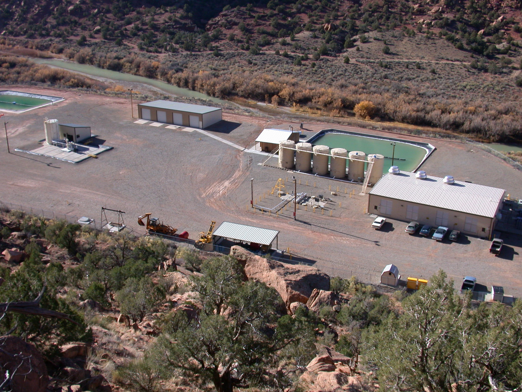
Paradox Valley Unit Facility in western Colo. Photo credit: Reclamation
Click the link to read the release on the Reclamation website (Justyn Liff and Becki Bryant):
The Bureau of Reclamation today [June 1, 2022] restarted operations of the Paradox Valley Unit (PVU), a crucial salinity control facility for the Colorado River system. For the next six months, the PVU will operate at a reduced capacity to gather data that will help guide future operational decisions.
Located in a remote area of western Colorado, along the Dolores River in Montrose County, the PVU removes an average of 95,000 tons of salt annually from the Dolores and Colorado rivers. It does this by extracting brine groundwater in the Paradox Valley and injecting it into a deep injection well, thereby preventing it from entering the Dolores River, which is a major tributary of the Colorado River. Saline concentrations of this naturally occurring brine groundwater have measured in excess of 250,000 milligrams per liter—about eight times saltier than seawater—and have contributed up to 200,000 tons of salt per year to the Colorado River system.
Prior to the restart, the Paradox injection well had been shut down since March 2019, when a 4.5 magnitude earthquake was recorded at the site. Though there was no damage to the well or surrounding area, injection was suspended to model injection formation pressure, monitor and analyze seismic activity, and to perform a seismic hazard analysis to ensure safe operation. Reclamation has determined that seismic activity at the site has significantly decreased and that resuming operations at a reduced rate under close watch is acceptable.
“The safety of our personnel and that of the community is our primary concern,” said Upper Colorado Regional Director Wayne Pullan. “After ceasing operations of the unit and thorough inspections, we want to ensure the community that we are ready to test the site by operating the unit at a reduced capacity for continued evaluation and assessment.”
The six-month-long operational test will consist of injecting brine groundwater into the 16,000-foot-deep well at a reduced rate of 115 gallons per minute, which is 67% of past operations. Modeling indicates that this reduced rate will have a negligible impact on seismicity and Reclamation will closely monitor the injection pressure and seismic response. If any unfavorable conditions develop, such as increased magnitudes in seismicity, operation will be suspended until it is deemed safe to continue.
“The injection test results will be used to evaluate well conditions and help Reclamation create a plan for potential future injection operations,” said Western Colorado Area Office Manager Ed Warner. “A seismic risk analysis will be completed in 2023 and an operations plan may be developed, based upon the injection test results.”
The PVU started operations in 1996 and provides substantial benefits, up to $23 million annually, including improved water quality, increased life of municipal and industrial infrastructure, and increased crop yields for all downstream water users in the Colorado River Basin.
The Colorado River Basin Salinity Control Forum meeting was held May 11, where the Basin states participated in discussion and coordination regarding PVU operations, seismic risk analysis, and post-EIS direction, to include the start of this six-month injection well test.
For more information about the PVU, visit our website.
Dolores River Canyon near Paradox
Click the link to read “Reclamation resumes salt-water injection at reduced level as it evaluates seismic threat” on the Grand Junction Daily Sentinel website (Dennis Webb). Here’s an excerpt:
The agency’s Paradox Valley Unit has been used for decades to help keep salt from reaching the Dolores River, and ultimately the Colorado River. Salinity in the Colorado River watershed harms water quality, impacts municipal and industrial infrastructure and impairs crop yields within the river basin. The Bureau of Reclamation facility extracts brine groundwater in the Paradox Valley and injects it into a 16,000-foot-deep well, keeping it from reaching the Dolores River, a tributary of the Colorado River.
The groundwater has been measured to be about eight times saltier than seawater, with saline concentrations exceeding 250,000 milligrams per liter, according to the Bureau of Reclamation. It estimates that its project has kept an average of about 95,000 tons of salt a year from reaching the rivers through operation of the injection well from 1996, when operations started, through 2019. This has resulted in up to $23 million in annual benefits by reducing river salinity and its impacts. The wastewater injection has a drawback, however, in that it induces seismic activity that has worsened over the years. In March 2019 a magnitude 4.5 associated with the facility was felt as far away as Grand Junction and Moab. It was the largest quake that has been linked to the injection well.
Following that quake, the Bureau of Reclamation suspended operations at the well for more than a year before briefly resuming them on a test basis. It also considered alternative salinity control measures in the Paradox Valley, including drilling and operating a new well at one of two new locations, using evaporation ponds, or building a plant to heat the brine to crystallize and remove the salt. But it ultimately decided against pursuing any of those due to concerns about things such as cost and potential aesthetic and wildlife impacts.