The health of our waters is the principal measure of how we live on the land — Luna Leopold
Historic rain event floods, wrecks #Yellowstone: Park closes all entrances after record-shattering precipitation prompts evacuations, strands towns and washes out roads and bridges — WyoFile
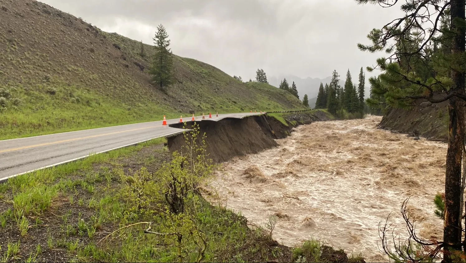
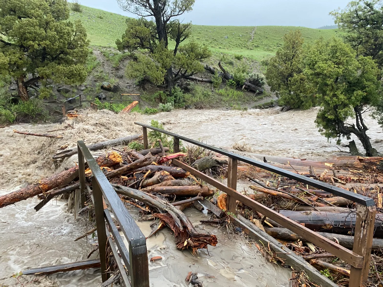
Yellowstone National Park’s Northeast Entrance Road washed out near Soda Butte Picnic Area on June 13, 2022. (National Park Service)
Click the link to read the article on the WyoFile website (Mike Koshmrl):
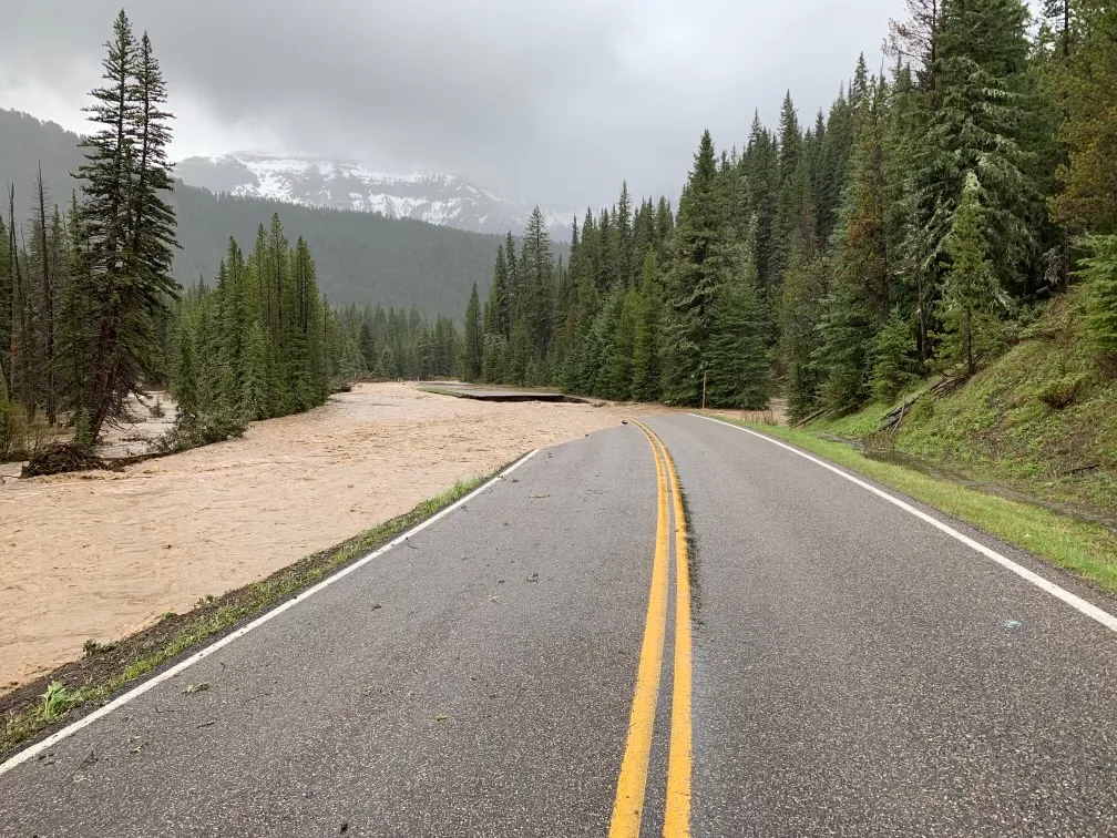
Unprecedented precipitation and flooding clobbered Yellowstone National Park starting Sunday, destroying bridges, making roads impassable, stranding scores of people and wreaking untold havoc on infrastructure within Northwest Wyoming’s tourism engine. The scope of the damage prompted park officials to close all park entrances Monday.
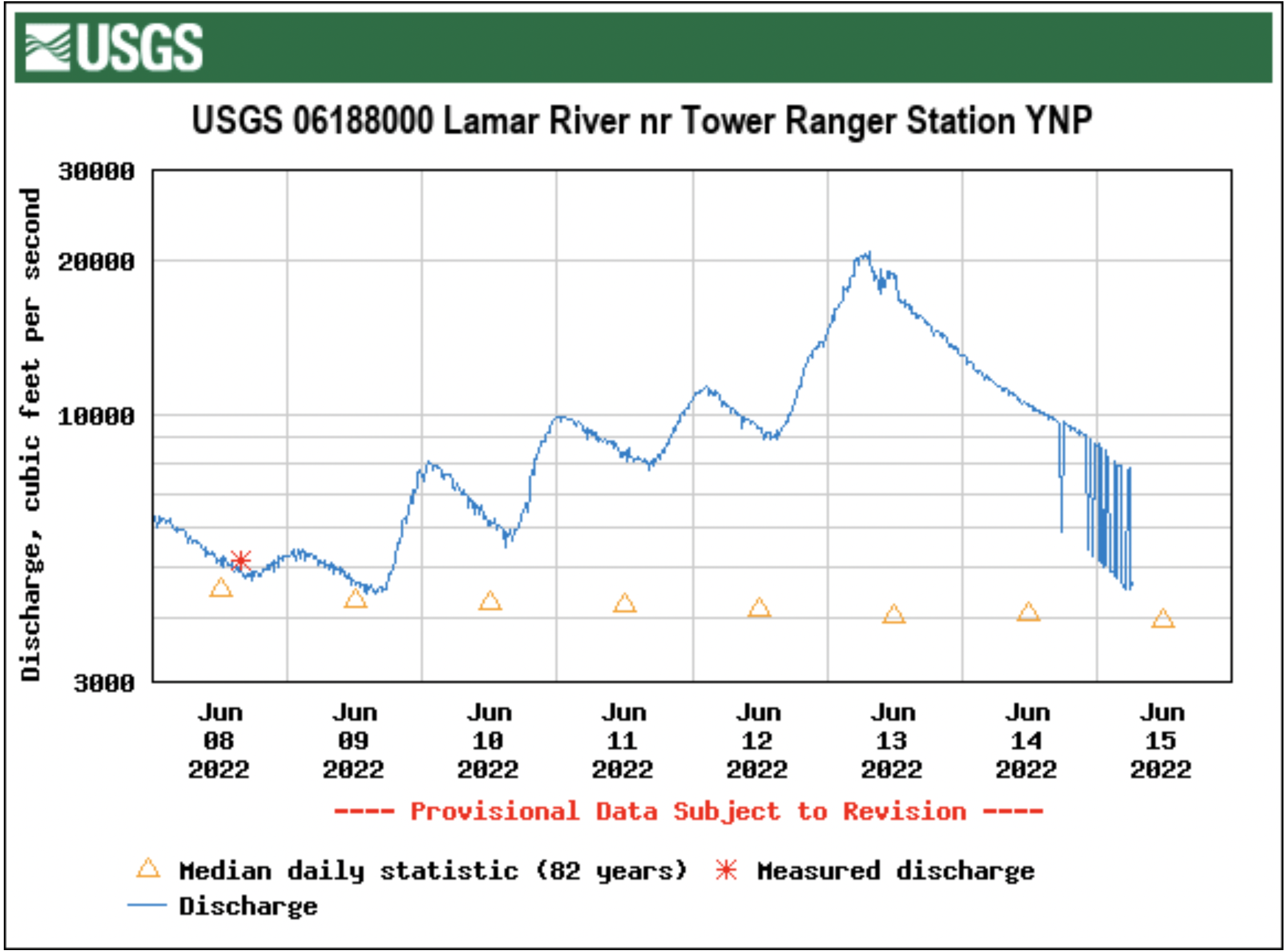
A U.S. Geological Survey gauge on the Lamar River near the Tower Ranger Station tells the tale of the remarkable weather event. The tributary to the Yellowstone River on Monday topped 18,000 cubic feet of water per second, which surpassed the previous daily record by nearly 50%. The Lamar rose so high that its peak water level, 17 feet over the riverbed, surpassed the gauge’s “operational limit” by 2 feet, and the water level was 5 feet higher than during any other time in 82 years of record keeping.
“It’s down to 15.5 feet right now, so at least it’s coming down,” National Weather Service meteorologist Jason Straub said Monday morning.
The weather calamity comes on the heels of an exceptionally dry winter, Natural Resources Conservation Service hydrologist Eric Larsen said. There was a record-low April 1 snowpack in the Yellowstone River headwaters, but that snow stuck around because of a wet, cool spring. Sunday and Monday’s torrential rains melted much of that snow, and the combined precipitation overwhelmed the waterways coursing through and surrounding the park.
“All the streamflows that would have been running over the last month, it’s all coming off right now, quickly,” Larsen said.
The Lamar River’s historic June 2022 flows eroded away the Northeast Entrance Road, which connects Yellowstone National Park headquarters in Mammoth Hot Springs with Silver Gate and Cooke City, Montana. (Yellowstone National Park)
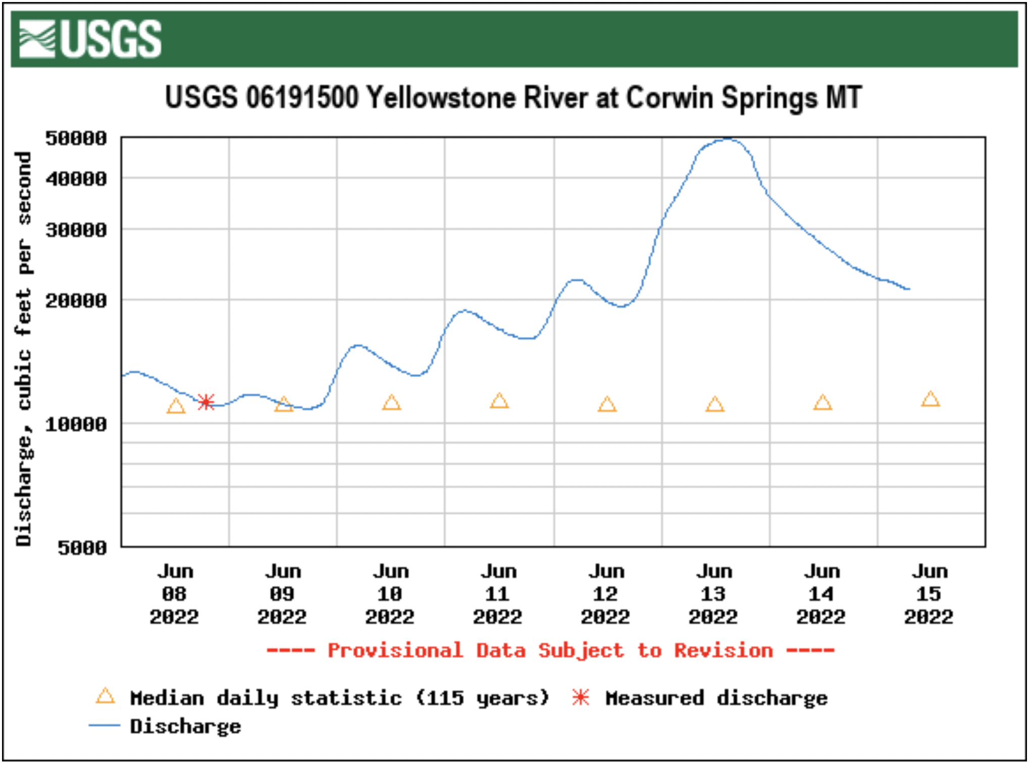
Flows are setting new hydrological high-water records in the Yellowstone River headwaters and well downstream into Montana.
“The Corwin Springs gauge on the Yellowstone, which is just upstream of my house, hit like 52,000 CFS, which is way higher than it’s ever been before,” Larsen said.
“It wiped out the Carbella bridge,” he said of the raging Yellowstone River.
Infrastructure in Yellowstone took such a beating that the National Park Service took the extraordinary step of shutting down all entrances into the park midmorning Monday. Park gates won’t open to inbound traffic Tuesday or Wednesday, officials announced in a press release.
“Due to record flooding events in the park and more precipitation in the forecast, we have made the decision to close Yellowstone to all inbound visitation,” Superintendent Cam Sholly said in a statement. “We will not know the timing of the park’s reopening until flood waters subside and we’re able to assess the damage throughout the park. It is likely that the northern loop will be closed for a substantial amount of time.”
The community of Gardiner, Montana — home to many Yellowstone headquarters staffers — was “currently isolated,” as of Sholly’s midday statement: “We are working with the county and State of Montana to provide necessary support to residents, who are currently without water and power in some areas.”
A footbridge across the Gardner River along the Rescue Creek Trail was totally destroyed by the flooding event in Yellowstone National Park on June 13, 2022 (Yellowstone National Park)
Evacuations took place within the park and in locations just outside.
The Cooke City-Silver Gate Volunteer Fire Department reported that there was “major flooding” in those two neighboring communities and that the Bannock Bridge in Cooke City is “gone.”
Silvergate was evacuated at 3 a.m. Monday, a host for the Beartooth Cafe told WyoFile.
There were also overnight evacuations in the Roosevelt area, according to Yellowstone visitors who posted online.
Yellowstone’s southern loop fared better initially, but was still being evacuated over the course of Monday, Sholly said in the statement. That’s due, he said, to “predictions of higher flood levels” and “concerns with water and wastewater systems.”
The rain that fell in Yellowstone Sunday and Monday sailed past daily records, Straub said. A rain gauge on the Gibbon River near Norris Junction tallied 1.63 inches of precipitation by 9 a.m. Tuesday. A site on the north side of Yellowstone Lake recorded up 1.75 inches, beating the old daily record, 0.43 inches, by more than 400%, he said.
“Single day observations over an inch are very rare,” Straub said. “We were already getting snowmelt, and add this 1 to 2 inches of rainfall and it started flowing fast into the valleys.”
Northwest Wyoming was forecasting “periodic showers” into Tuesday, he said. Those rains could drop “a tenth or two-tenths” of precipitation at a time, but should abate by Tuesday evening.
In the meantime, Straud cautioned area travelers to make good choices.
“Keep away from any flooded roads,” he said, “and don’t go around barriers.”
It’s all but assured there will be longer-term impacts to commerce and business in Yellowstone, said Mike Keller, general manager for the park’s largest concessionaire, Xanterra.
“The road between Mammoth and Gardiner is pretty much gone in several places,” Keller said. “It’s completely eroded, plus into the hillside beyond. There are some roads in this park that are not going to reopen for a period of time.”
All of Xanterra’s guests in the park are in the process of being evacuated. Employees, for now, are being allowed to stay.
“We’ve closed everything in the park through Thursday night,” Keller said Monday afternoon. “We’re hoping to start opening things back up Friday, but the rivers still haven’t peaked yet.”
MIKE KOSHMRL
Mike Koshmrl reports from Jackson on state politics and Wyoming’s natural resources. Prior to joining WyoFile, he spent nearly a decade covering the Greater Yellowstone Ecosystem’s wild places and creatures.
WyoFile is an independent nonprofit news organization focused on Wyoming people, places and policy.
Severe flooding due to unprecedented heavy rain on snow is forcing the closure and evacuation of Yellowstone National Park.
Mudslides, rockslides and flooding are wiping out roads and bridges across the region.