Michael Bennet. Photo credit: WikipediaJoe O’Dea. Photo credit: Wikipedia
Click the link to read the article on The Buzz website (Floyd Ciruli):
The Colorado senate race is being closely followed by the national media for indications of a Republican tide that could sweep even an incumbent out of a state that has been supporting Democrats since 2016.
In July, Mark Barabak wrote a column for the L.A. Times, “How bad could November be for Democrats? Watch this Senate race and see.” (7-26-22). I said it about incumbent Democrat Michael Bennett.
“He’s not in danger yet,” said Floyd Ciruli, a Denver pollster who has spent decades surveying Colorado voters. “But [President] Biden is in terrible shape and if that becomes a major factor, a lot of candidates we assume would be safe could be in trouble.”
The Denver Post updated the senate race in a weekend story by Nick Coltrain (9-10-22). He reported that mixed signals from polls still don’t show a Republican win and that the national party has not put much money behind their candidate, Joe O’ Dea. (Since the story appeared, McConnell gave $500,000)
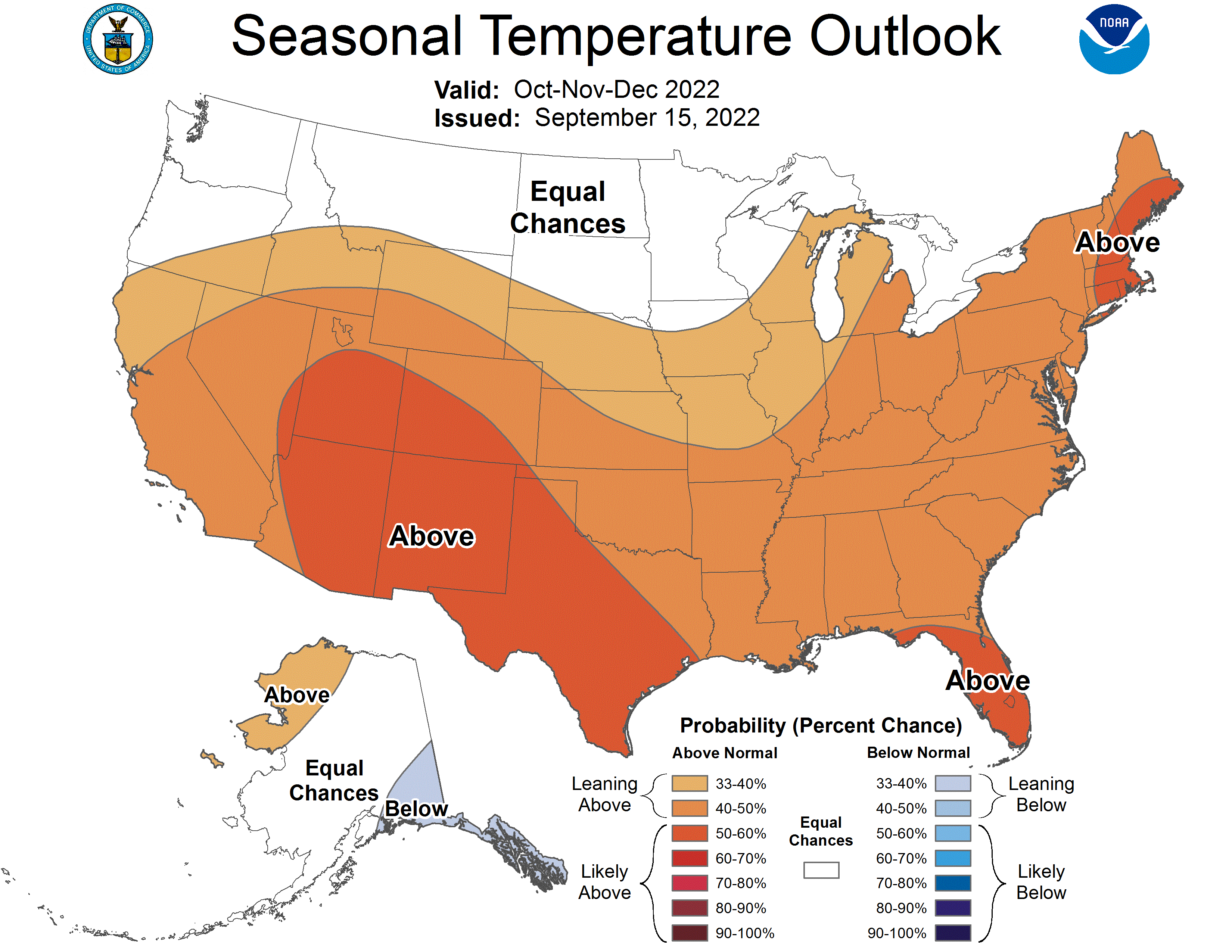
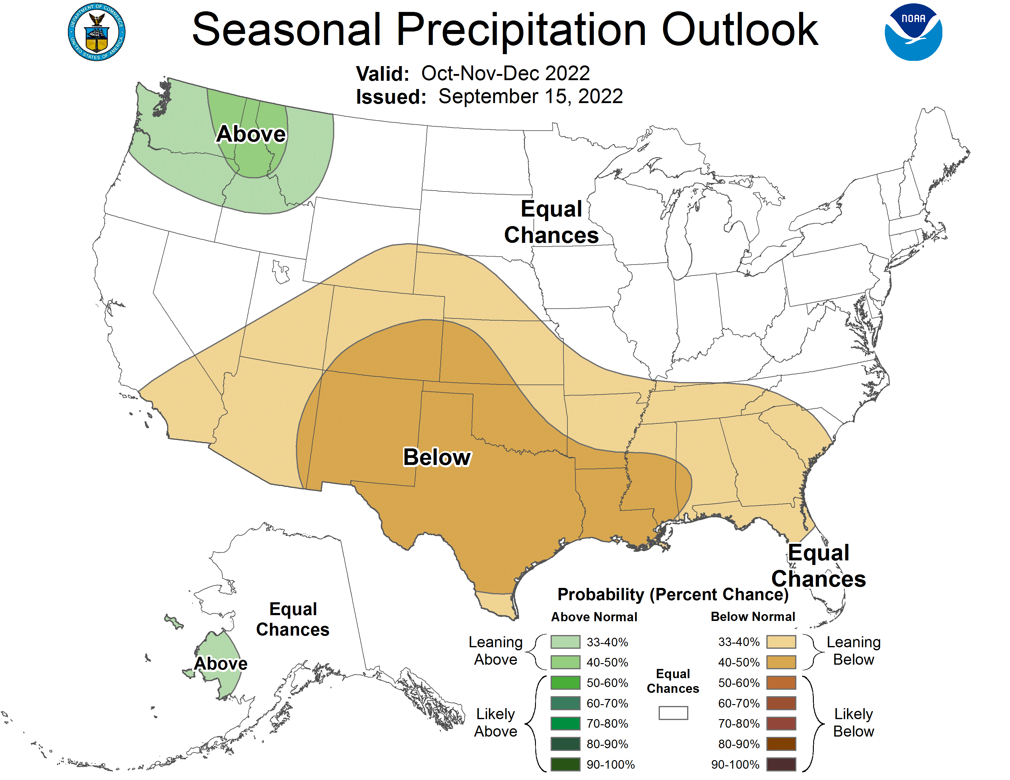
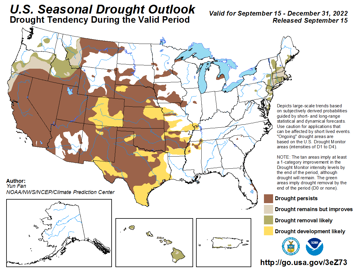
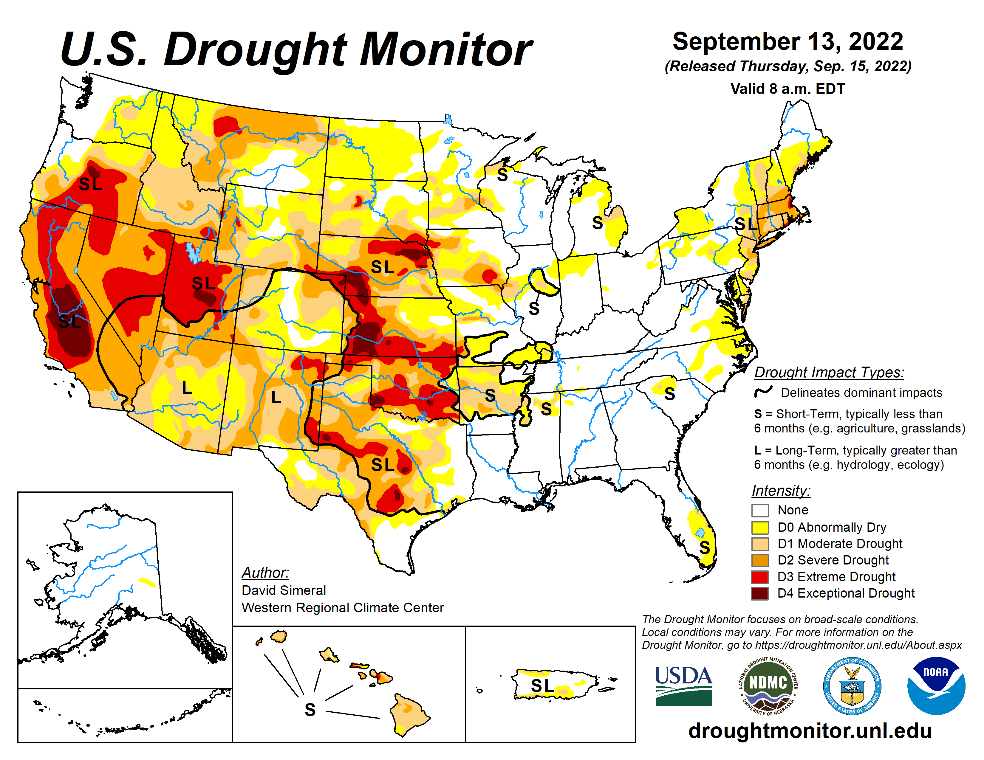
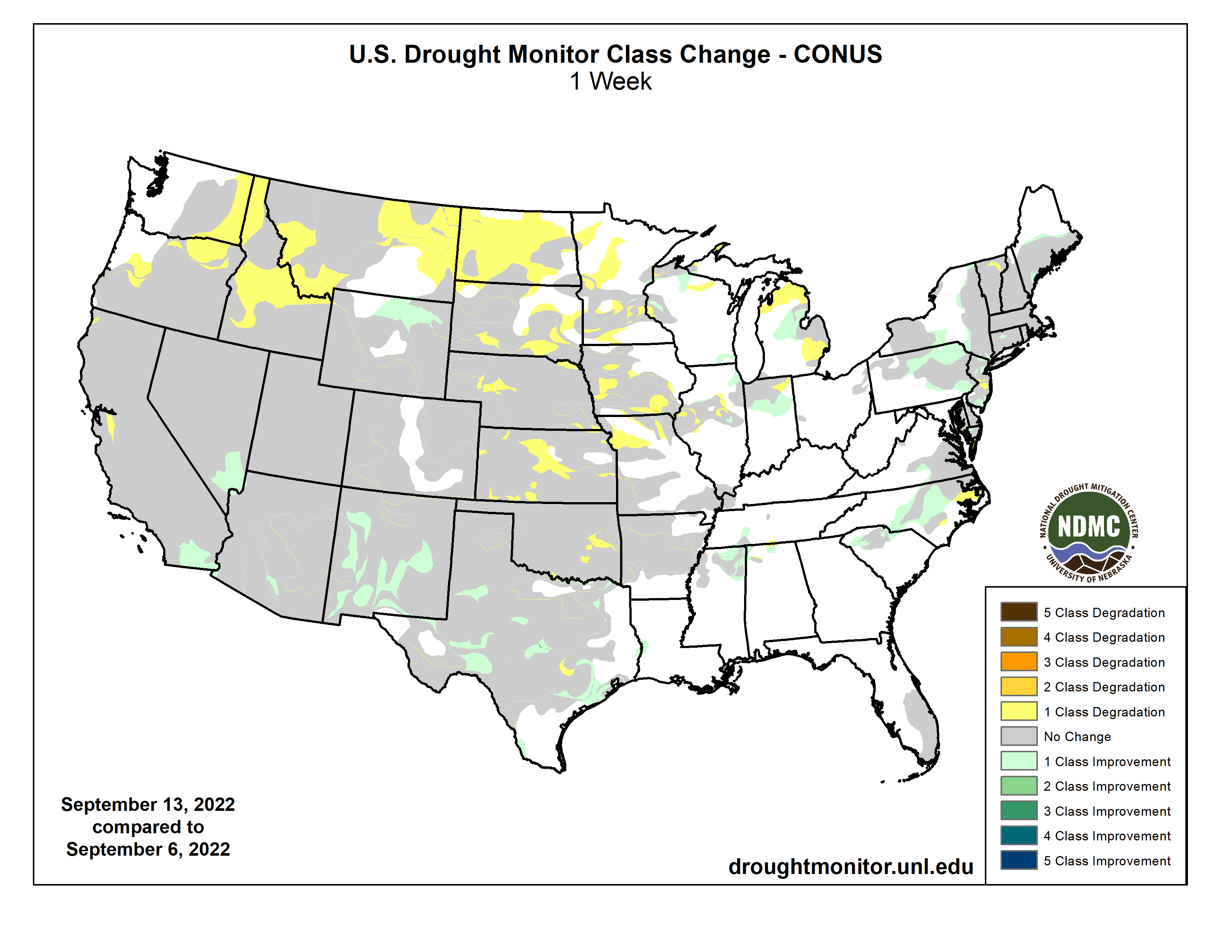
This U.S. Drought Monitor (USDM) week saw areas of isolated heavy rainfall in Southern California and the Desert Southwest in association with remnant moisture from Tropical Cyclone Kay late last week. Over the weekend and early this week, the residual moisture from the system moved further onshore impacting areas including Southern California, southern Sierra Nevada, Desert Southwest, and portions of the Great Basin. Overall, the heaviest accumulations were observed in very isolated higher-elevation areas of the Peninsular Ranges and Transverse Ranges of Southern California with accumulations ranging from 3 to 5-inches in addition to reports of wind gusts between 70-100 mph. Unfortunately, the overall impact of the precipitation on the long-term drought in California was negligible. In the High Plains, above-normal temperatures (2 to 6 deg F) and generally dry conditions during the past week continued to exacerbate drought conditions across areas of the central and northern Plains, with a growing number of drought impacts within the agricultural sector being reported to the National Drought Mitigation Center. In Texas, areas of isolated heavy rainfall accumulations (3 to 5+ inches) this week continued to ease drought-related conditions in the Rio Grande Valley and South Texas. In the Midwest, widespread heavy rainfall accumulations ranging from 2 to 6+ inches impacted northern Illinois and southern Wisconsin over the weekend—erasing some of the short-term precipitation deficits. Elsewhere in the region, a combination of short and longer-term precipitation deficits in Iowa led to degradation on the map, with rainfall deficits during the past 90-day period ranging from 4 to 8+ inches in southern Iowa. In the Northeast and Mid-Atlantic states, widespread shower activity this week helped to improve drought-related conditions in the southern portion of the Northeast region as well as alleviate short-term (past 30-60 days) precipitation deficits in areas of the Coastal Plain and Piedmont of North Carolina. In the Southeast, most of the region remained drought-free with exception of coastal areas of east-central and southern Florida, where rainfall deficits for the past 90-day period ranged from 4 to 12+ inches, causing some concerns regarding hydrologic drought (some low groundwater and surface water levels) with the end of the wet season approaching. Looking back at the 2022 summer months, the contiguous U.S. experienced its 3rd warmest June-August period on record since 1895 in terms of average temperatures (+2.52 deg F anomaly). Average minimum temperatures nationwide for August (+3.20 deg F) and the July-August (+3.12 deg F) periods were the warmest on record, according to NOAA National Centers for Environmental Information (NCEI). Precipitation in the contiguous U.S. during August and the July-August 2022 period ranked at 19th and 28th wettest, respectively, placing it in the top 1/3rd wettest…
On this week’s map, degradations were made in areas of Kansas, Nebraska, South Dakota, and North Dakota in response to continued dryness, decreased soil moisture, poor pasture and rangeland conditions, and impacts to dryland crops. In Kansas and Nebraska, the latest 7-day streamflow levels were showing widespread well-below-normal flows, especially in Nebraska. In southern Nebraska, numerous gaging stations on rivers and creeks were observing flows in the 1st to 2nd percentile range, according to the U.S. Geological Survey. For the week, average temperatures were above normal in the Dakotas (1 to 4 deg F) while Nebraska, eastern Wyoming, and Kansas were near normal to slightly below normal. According to NOAA NCEI, the Great Plains Region saw its 5th warmest (+2.7 deg F) and 19th driest June-August on record. Statewide, Nebraska experienced its 3rd driest June-August as well as its 2nd driest August on record…
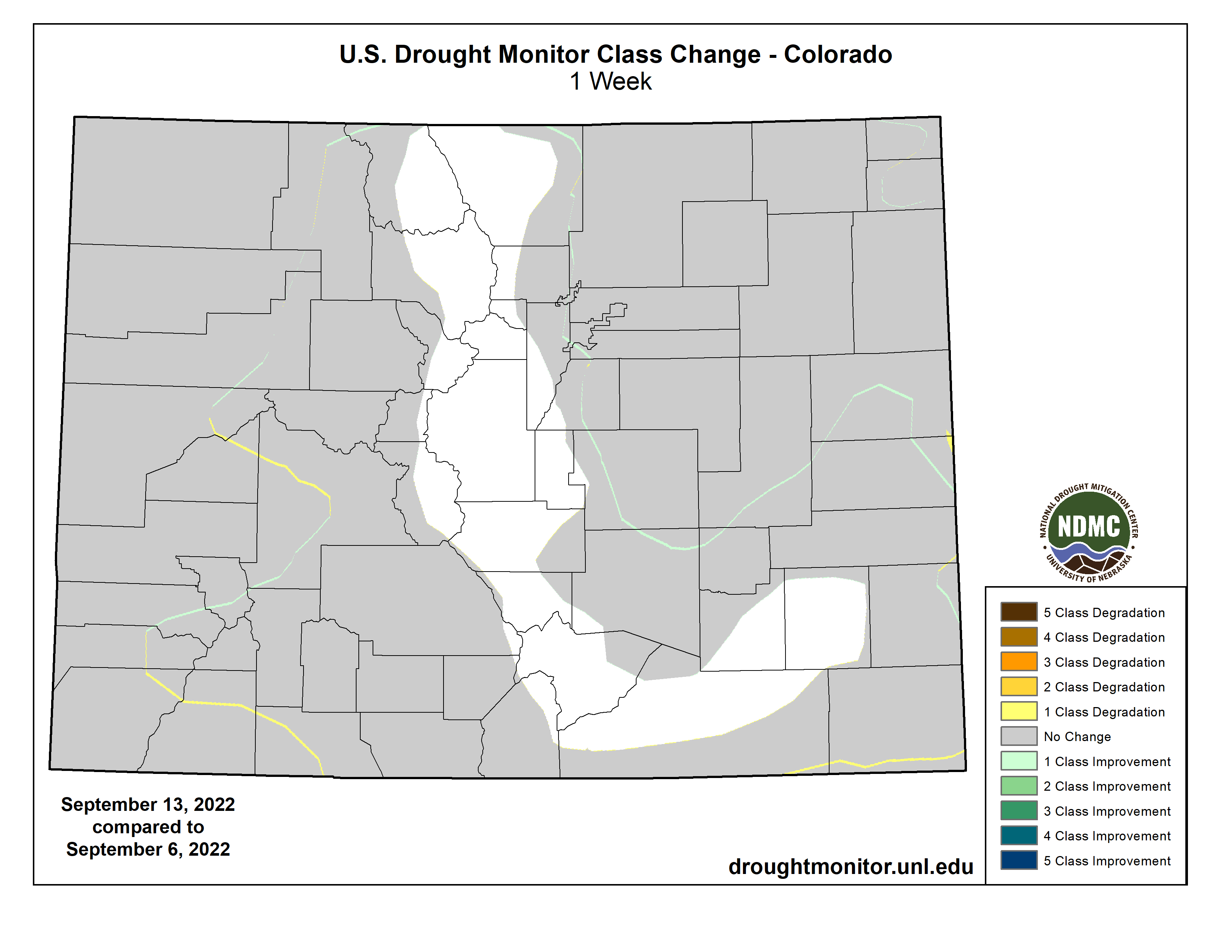
Colorado Drought Monitor one week change map ending September 13, 2022.
Out West, numerous large wildland fires are currently burning across areas of California, Oregon, and Idaho causing evacuations, damage to structures, and reduced air quality. On this week’s map, some improvements were made in southeastern California, southern Nevada, and New Mexico in response to rainfall this week associated with residual moisture from Tropical Cyclone Kay as well as the overall impact of this summer’s monsoonal rainfall that has helped improve short-term meteorological drought conditions and vegetation health. Elsewhere in the region, a combination of short and long-term dryness, low streamflow, and declining soil moisture led to intensification of drought in areas of Montana and Idaho. For the week, average temperatures were 2 to 10+ degrees above normal across California, the Great Basin, northern portions of Arizona and New Mexico, and portions of the Pacific Northwest. Conversely, cloud cover associated with the remnants of Kay reduced daytime heating in the southeastern deserts of California and southern portions of Arizona and New Mexico, where average temperatures were 2 to 6 degrees below normal. According to NOAA NCEI, the June-August 2022 period was the 3rd warmest on record for the West Climate Region, which includes California and Nevada. Additionally, in terms of average minimum temperatures, both August (+5.6 deg F) and the July-August (+4.8 deg F) periods were the warmest on record. Looking at precipitation, it was the 8th wettest August on record for the West Climate Region and the driest (-6.95 inches) January-August period on record. For the Southwest Climate Region, it was the 7th wettest June-August period on record and the 7th warmest for the contemporaneous period. In the Northwest Climate Region, August (+6.2 deg F) and the July-August (+5.3 deg F) period were the warmest on record…
In the South, improvements were made across isolated areas of Mississippi, Tennessee, and Texas. Degradations were made on the map in areas of Oklahoma, where rainfall deficits during the past 90-day period ranged from -3 to -7+ inches. According to the Oklahoma Mesonet, the last 90-days were the 7th driest statewide with a -4.79-inch departure from normal (50% of normal). During the past week, rainfall accumulations across the region were generally light (<1 inches), with some isolated areas of Mississippi, southeastern Arkansas, Tennessee, and southern Texas receiving 2-inch accumulations. For the week, average temperatures were near normal across the region. According to NOAA NCEI, the South Climate Region experienced its 12th wettest August on record due to well-above-normal rainfall across areas of Texas, Louisiana, and Mississippi. For the June-August period, average temperatures for the South Climate Region ranked 5th warmest, with Texas ranking 2nd warmest for the contemporaneous period…
Looking Ahead
The NWS WPC 7-Day Quantitative Precipitation Forecast (QPF) calls for moderate-to-heavy precipitation accumulations ranging from 2 to 4+ inches across areas of the Upper Midwest, with the heaviest amounts expected in Upper Peninsula Michigan and northeastern Minnesota. Likewise, 2 to 4+ inch accumulations are expected across areas of Florida. Elsewhere, lesser accumulations ranging from 1 to 2+ inches are forecasted for northern portions of New England as well as areas out West including the Northern Rockies, Wasatch Range, eastern Great Basin, and portions of the Southern and Central Rockies. The CPC 6-10-day Outlooks calls for a moderate-to-high probability of above-normal temperatures for all areas east of the Rockies, while much of the West is expected to be cooler than normal with exception of coastal areas of California. Precipitation is forecasted to be above normal across much of the West. Below-normal precipitation is expected across most of the Eastern Tier.
US Drought Monitor one week change map ending September 13, 2022.
Releases from the Aspinall Unit will be decreased from 1450 cfs to 1350 cfs on Thursday, September 15th. Releases are being decreased due to the cooler and wetter conditions that have caused the river to rise above the baseflow target on the lower Gunnison River. The actual April-July runoff volume for Blue Mesa Reservoir came in at 68% of average.
Flows in the lower Gunnison River are currently above the baseflow target of 890 cfs. River flows are expected to remain above the baseflow target for the foreseeable future.
Pursuant to the Aspinall Unit Operations Record of Decision (ROD), the baseflow target in the lower Gunnison River, as measured at the Whitewater gage, is 890 cfs for September.
Currently, Gunnison Tunnel diversions are 1050 cfs and flows in the Gunnison River through the Black Canyon are around 440 cfs. After this release change Gunnison Tunnel diversions will still be around 1050 cfs and flows in the Gunnison River through the Black Canyon will be near 340 cfs. Current flow information is obtained from provisional data that may undergo revision subsequent to review.
Click the link to read the article on the Yahoo! Finance website (Grace O’Donnell). Here’s an excerpt:
“You know, our farmers and ranchers are used to dealing with curveballs coming their way, but we’re in a new era,” Kate Greenberg, commissioner of the Colorado Department of Agriculture, told Yahoo Finance Live (video above). “We’re really thinking about diversity, resilience, perseverance to make sure that we can keep producing food here in Colorado, knowing we’re under a future of less water.”
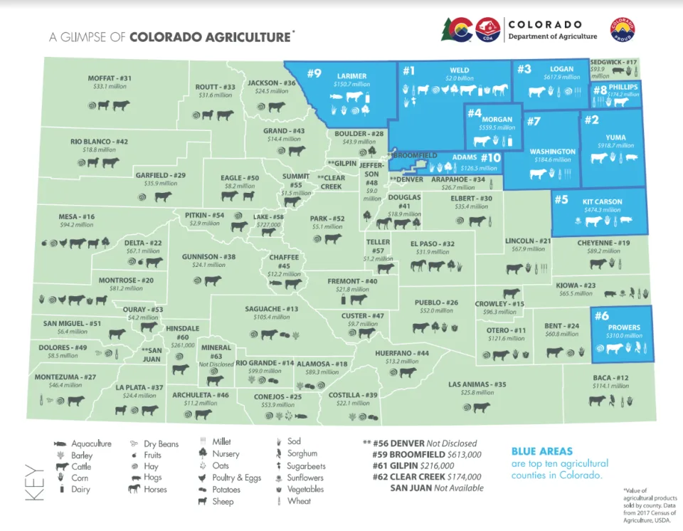
As of August 30, nearly half of the state (46%) is experiencing drought conditions, while 86% of the state is classified as “abnormally dry,” according to the latest Drought Monitor report. The most severely drought-stricken areas also happen to overlap with the top agricultural-producing counties in the state, as seen in the maps below. Agriculture makes up a $47 billion industry in the state, around a tenth of Colorado’s gross economic output, and employs over 195,000 workers. Cattle is the top commodity produced in the state…
Colorado Drought Monitor map Septermber 13, 2022.
Greenberg explained that Colorado farmers and ranchers started adapting by diversifying revenue streams, including building solar farms and looking at new ways of production that use less water. The Department of Agriculture also announced a $1.9 million investment into drought preparedness projects, including grants to farmers and funding for water infrastructure…
The top agricultural producing counties in Colorado are experiencing drought. (Colorado Department of Agriculture)
“We’re dealing with both the surface water and the groundwater issues out here in many of our basins,” Greenberg said. “While we’re experiencing this tightening in both the surface and the groundwater, we’re also seeing development of new technologies, new forms of collaboration, new ways of thinking about how we support our local economies in a drier future.”
Drawing to end of growing season and start of #harvest22. #drought22 showing its issue in condition reports. Worst in #plains. Not as bad central #cornbelt.