Click the link to read the article on the Associated Press website (Brittany Peterson). Here’s an excerpt:
Key Colorado River reservoirs Lake Powell and Lake Mead are both only about one-quarter full. The continued drop, due to overuse and an increasingly arid climate, is threatening the fish and the economies built around them…since late August, the water temperature at Lees Ferry — the site of a world-famous trout fishery — has risen above 70 degrees seven times. That might be idyllic for a summer dip under the blazing Arizona summer sun, Gunn said, but approaches peril for the beloved sport fish. A few degrees higher can be lethal. To make matters worse, when temperatures rise, the amount of oxygen dissolved in the water falls, making it tough for fish to even breathe.
The Colorado River from Navajo Bridge below Lee’s Ferry and Glen Canyon Dam. The proposed Marble Canyon Dam would have been just downstream from here. Jonathan P. Thompson photo.
As the reservoir drops, it sends warmer water with less oxygen into the river below the dam. Should that water reach 73 degrees, [Terry] Gunn said his family’s guide service could start calling off afternoon trips…
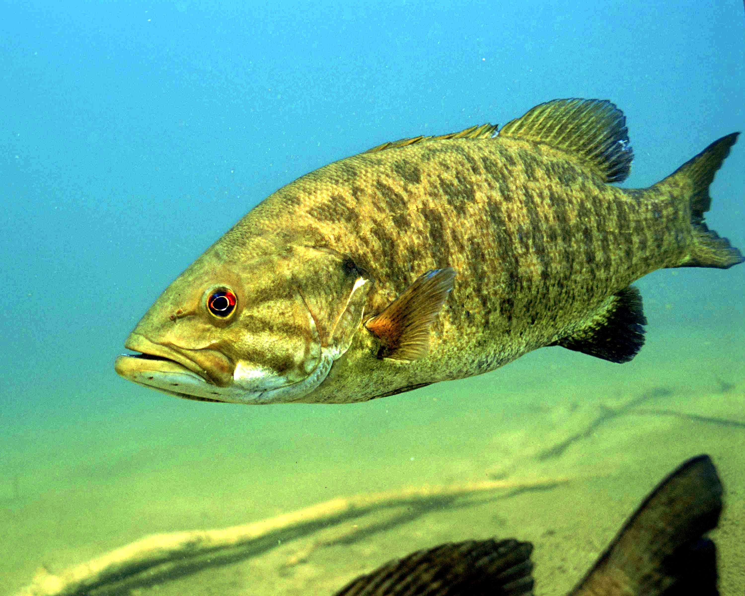
Just a few miles north of Lees Ferry and its trout fishery there’s another threat — nonnative predatory smallmouth bass. They’re supposed to be contained in Lake Powell. But this summer they were found in the river below the dam. Smallmouth bass already wreaked havoc on native fish way upriver where the government spends millions of dollars each year to control the predators. They were held at bay in Lake Powell because Glen Canyon Dam has served as a barrier for them for years — until now. The reservoir’s recent sharp decline is enabling these introduced fish to shoot through the dam and edge closer to the Grand Canyon, where the biggest groups of humpback chub, an ancient, threatened, native fish, remain.
Colorado Parks and Wildlife staff found an adult zebra mussel at the popular Grand Valley boating destination on Wednesday during routine invasive-species sampling, and said Friday that two of its experts independently confirmed the identification of the mussel, including through genetic confirmation…This is the first-ever discovery of an adult zebra or quagga mussel in Colorado. Both are native to Europe and pose concern because they quickly reproduce and spread to new waters, clogging pipes and other infrastructure with their shells and posing ecological impacts as they filter out and eat plankton, threatening the aquatic food chain and fisheries.
In May of 2018, USGS Hydrologic Technician Dave Knauer found a batch of zebra mussels attached to the boat anchor in the St. Lawrence River in New York. (Credit: John Byrnes, USGS. Public domain.)
Colorado has had intensive protocols in place in an attempt to keep the two species out of the state. On occasion larval-stage mussel “veligers” have been found in some state reservoirs or lakes, but fortunately in all those cases, the mussels never established themselves in those water bodies, all of which are now considered negative for them. Under the precautionary protocols followed in Colorado whenever there is a single confirmed instance of either mussel being present at any age in a water body, however, boats leaving Highline will now be subject for three years to mandatory inspection, and if necessary decontamination, to prevent the mussel from spreading elsewhere. If three years pass without further detections, the measures can be dropped.
Before dirt was moved at Chimney Hollow Reservoir in 2021, Northern Water implemented several environmental improvements nearby as part of our commitment to offset any environmental impacts of the new reservoir. A section of the Little Thompson River in Berthoud, and a second section north of Lyons, both decimated by the 2013 flood, received compensatory mitigation including the repair of natural channels and replanted vegetation. An area in west Loveland along the Big Thompson River, also impacted by the flood, had a diversion structure removed, the natural channel restored, and cottonwood and willow trees replanted.
The Big Thompson Watershed Coalition, Windy Gap Firming Project participants, AloTerra Restoration Services, ERO Monitoring and the Northern Water Municipal Subdistrict identified sites, completed restoration at each, and began the monitoring and reporting phase which are required as part a permit granted under Section 404 of the Clean Water Act. Water resource projects that result in impacts to Waters of the United States, such as Chimney Hollow Reservoir, are required to obtain such a permit before altering or impacting a project site. While a steadfast objective of the Chimney Hollow Reservoir Project is to minimize environmental impacts, some are unavoidable. To compensate for this, Section 404 allows project participants to identify and enhance other areas in need of restoration.
These improvements have already had positive impacts on water flows, ecological health and fisheries and we expect the Army Corps of Engineers will sign off soon that the restoration projects were successfully completed.
Click the link to read the guest column on the USFS website (Cynthia West):
Acting Deputy Chief Dr. Cynthia West, Research and Development
Record heat waves and drought are not only leading to more frequent and intense wildfires but are also putting one of life’s most valuable resources at risk: the water we drink.
Access to high-quality water will be a defining feature of the 21st century. Water use per person has been declining for decades; however, a variety of factors are contributing to overall greater water demand, including population growth, increased demand for irrigated food crops, and impacts from drought and climate change. At the same time, warming will result in a reduction of water available to all ecosystems, including forested ecosystems. Maintaining the health and extent of current forests will be key to providing consistent water supplies into the future.
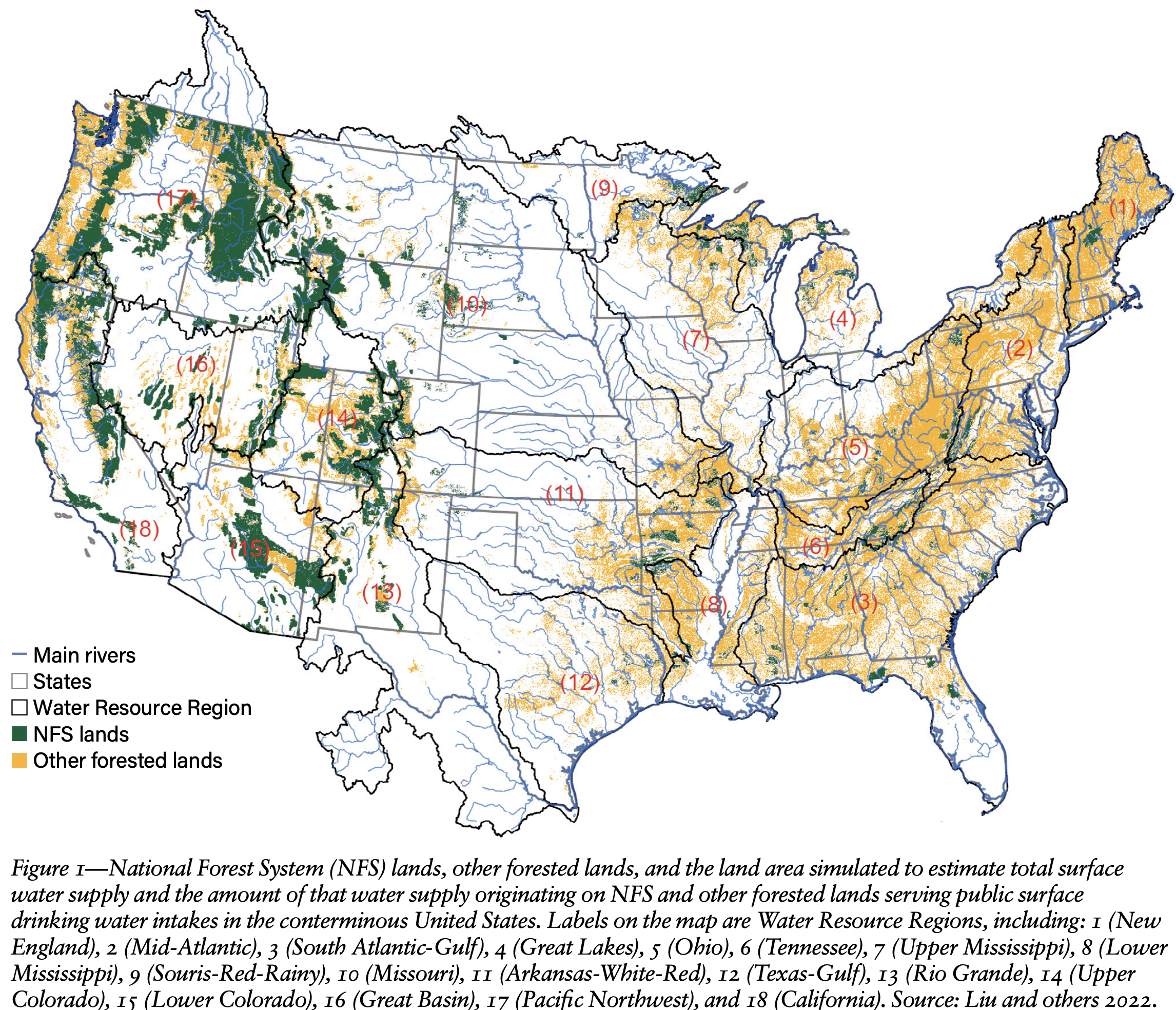
I’d like to highlight a few key messages from the report that demonstrate how critical national forests are to our drinking water supply in the lower 48 states. In the West, national forests and grasslands supply drinking water to almost 90% of the people served by public water systems. Similarly, national forests and grasslands in the west comprise 19.2% of the total land area but contribute 46.3% of the surface water supply. Some western cities, like Aspen, Colorado, and Portland, Oregon, are over 90% dependent on national forests alone for their drinking water.
In the East, drinking water is still provided by forested lands, though these are mostly privately owned forests. Over a century of research has demonstrated that forested lands provide the cleanest and most stable water supply compared to other land types. Within the lower 48 states, over 99% of people who rely on public drinking water systems receive some of their drinking water from forested lands.
This is the first report to assess the contribution of individual national forests and grasslands to surface drinking water supplies while also accounting for inter-basin water transfers—networks of pipelines and canals that divert water from its source to high-need areas. Inter-basin transfers can be an important source of drinking water, particularly for western cities. The Los Angeles area, which serves 7.1 million people, receives over 68% of its water supply from forested lands in California and Colorado.
By showing where our drinking water comes from at a fine scale, this report supports implementation of USDA’s Wildfire Crisis Strategy, the Bipartisan Infrastructure Investment and Jobs Act, and the Inflation Reduction Act. The actionable information provided in this report will help land managers to prioritize forests and watersheds for hazardous fuels reduction, watershed management and restoration treatments.
I’m excited to see how this data helps land managers and policy makers in their efforts to protect communities from wildfire while maintaining clean and reliable drinking water.
Editor’s Note: Provide feedback about this column, submit questions or suggest topics for future columns through the FS-Employee Feedback inbox.
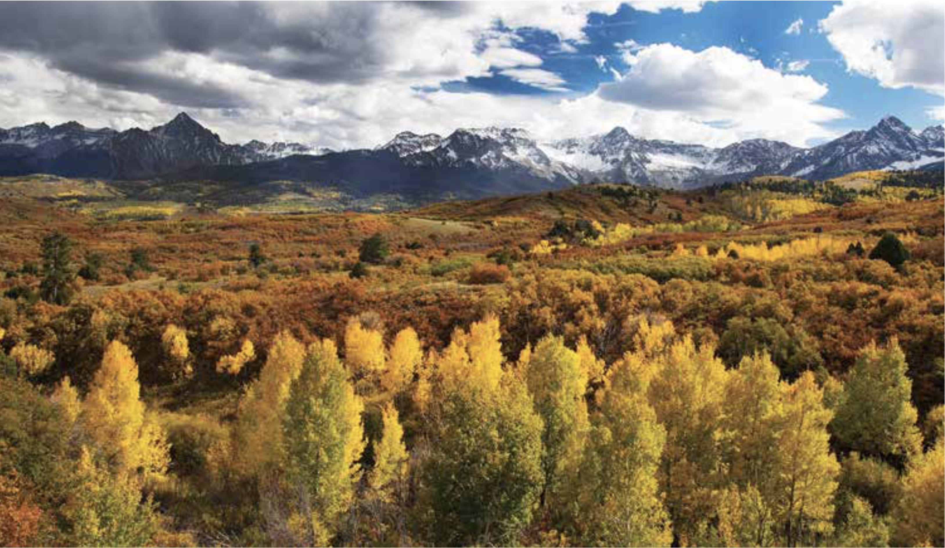
Aspen trees in autumn. Photo: Bob West via the Colorado State Forest Service.
Click the link to read the article on the NOAA website:
Key Points:
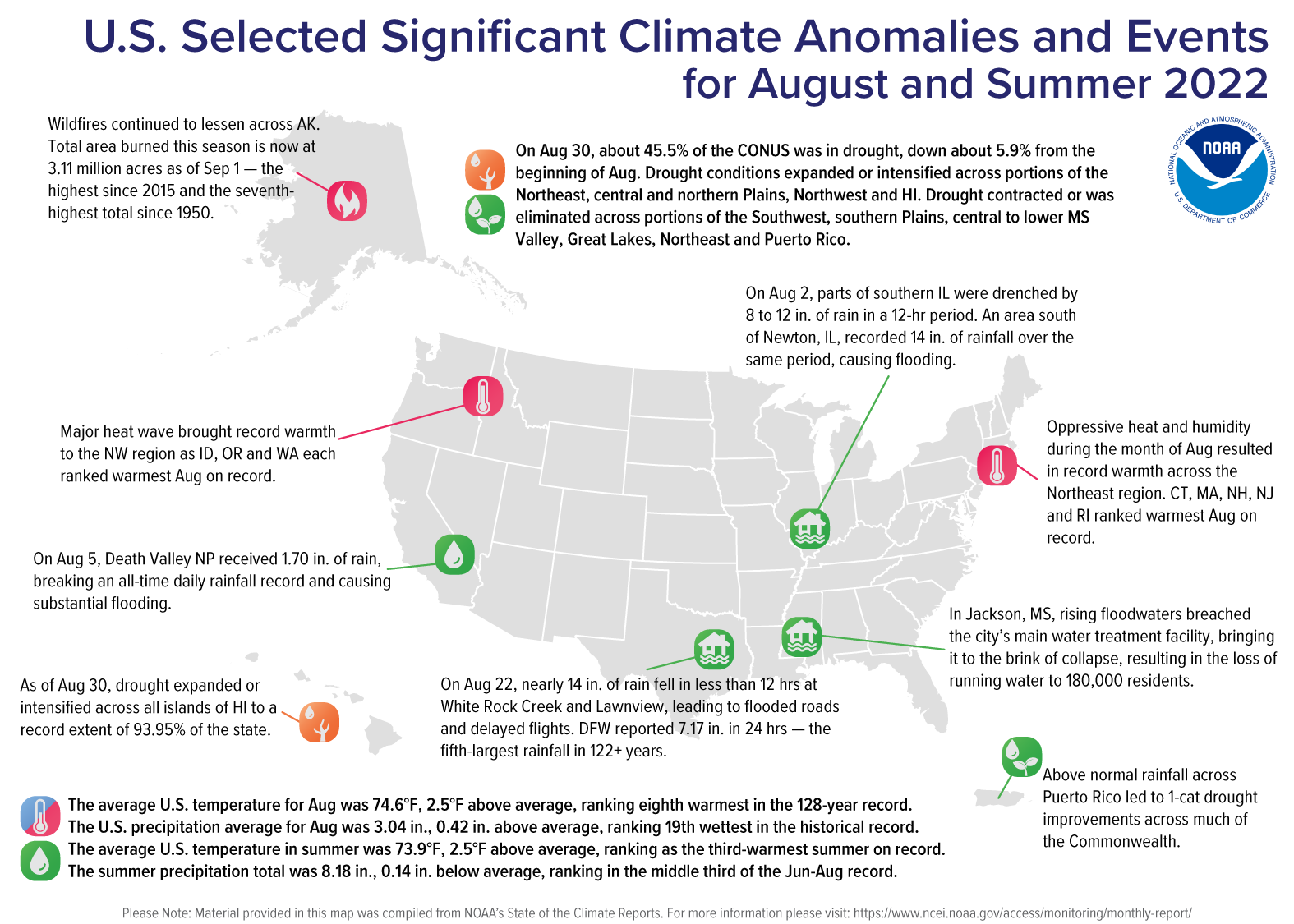
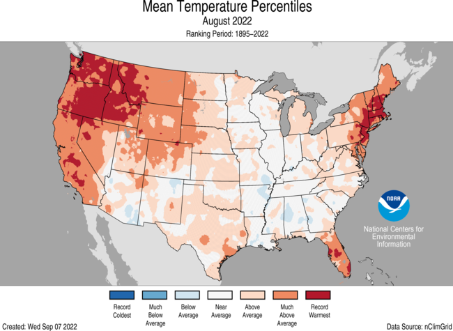
– The average temperature of the contiguous U.S. in August was 74.6°F, which is 2.5°F above average, ranking eighth warmest in the 128-year record. Generally temperatures were above average and/or record-warm across much of the U.S.
– The contiguous U.S. monthly average minimum temperature was record warm for the second month in a row during August. California, Oregon, Washington, Nevada and Idaho each ranked warmest on record for August nighttime temperatures.
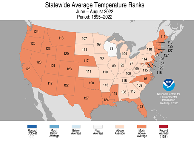
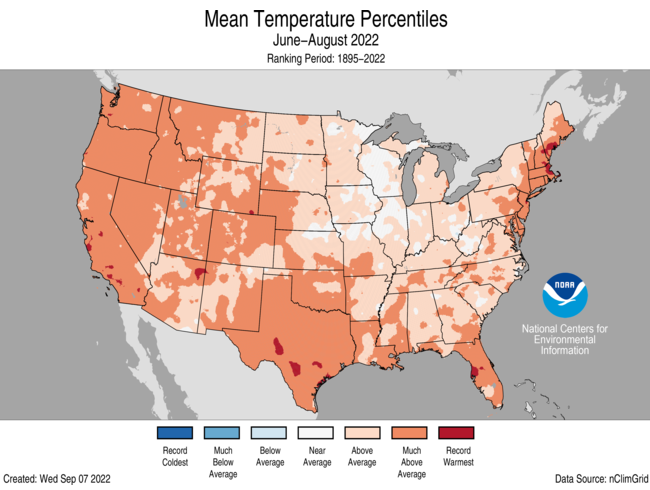
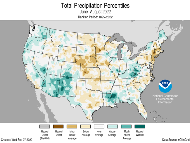
– The meteorological summer (June-August) average temperature for the Lower 48 was 73.9°F, 2.5°F above average, ranking as the third-warmest summer on record.
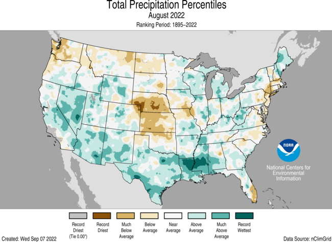
– August precipitation for the contiguous U.S. was 3.04 inches, 0.42 inch above average, ranking in the wettest third of the historical record. Precipitation was above average across parts of the Midwest, West, southern Mississippi Valley and Plains. Precipitation was below average across portions of the central and northern Plains, Northwest and parts of the northern Atlantic coastline.
– The National Weather Service deemed heavy rainfall episodes in southern Illinois, Death Valley National Park, and Dallas, TX as 1,000-year events. While extensive flooding occurred with the heavy rain, some of these events helped to reduce the severity of the drought across portions of the West and southern Plains.
– For the first time since 1997, there was no storm activity reported in the North Atlantic basin during the month of August.
– The wildfire season appears to be waning across Alaska but is still going strong across the West and southern Plains. Across all 50 states, more than 6 million acres burned from January 1 through August 31, 2022.
– According to the August 30 U.S. Drought Monitor report, 45.5 percent of the contiguous U.S. was in drought. Severe to exceptional drought was widespread from the Great Basin to the Pacific Coast, across portions of the central and southern Plains, and parts of New England.
Other Highlights:
Temperature
For the month of August, Washington, Oregon, Idaho, New Jersey, Connecticut, Rhode Island, Massachusetts and New Hampshire ranked warmest on record. In addition to this record warmth, near-record temperatures were widespread in the West and other parts of the Northeast. California had its second warmest August, with five additional states experiencing a top-five warmest August on record.
Summer temperatures were above average across most of the contiguous United States. Texas, Massachusetts and Rhode Island ranked second warmest while seventeen additional states across the West, South and Northeast ranked among their warmest 10 summer seasons on record.
For the January-August period, the average contiguous U.S. temperature was 55.4°F, 1.5°F above average, ranking in the warmest third of the record. Temperatures were above average from Oregon to the Gulf Coast and from the Gulf to New England. Florida ranked fourth warmest and California ranked fifth warmest on record for this period. Temperatures were below average across parts of the Upper Midwest.
The Alaska statewide August temperature was 50.1°F, 0.6°F above the long-term average. This ranked among the middle one-third of the 98-year period of record for the state. Temperatures were above average across much of eastern Alaska, Panhandle region, Kodiak Island and portions of the Kenai Peninsula. Temperatures were below average across portions of northwest Alaska.
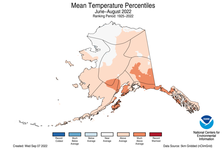
The Alaska summer temperature was 52.1°F, 1.6°F above the long-term average, ranking in the warmest third of the record for the state. Temperatures were above average across most of the state with the Northwest and areas along the Arctic near average for the season.
The Alaska January-August temperature was 31.2°F, 2.5°F above the long-term average, ranking in the warmest third of the record for the state. Above-average temperatures were observed across much of the state with portions of the North Slope, West Coast and eastern interior regions experiencing near-average conditions for this eight-month period.
Precipitation
Record rainfall events during the month of August contributed substantiallyto the record-wet August for Mississippi as well as the third-wettest August for Nevada and Louisiana. Conversely, a lack of precipitation received during the month resulted in Nebraska ranking second driest while Kansas had its seventh-driest August on record.
The U.S. summer precipitation total was 8.18 inches, 0.14 inch below average, ranking in the middle third of the June-August record. Precipitation was above average along the West Coast, much of the Southwest, Midwest, lower Mississippi Valley and northern New England for the season. Precipitation during June-August was below average across the Great Plains, southern New England, and other portions of the East Coast. Arizona ranked seventh wettest while Nebraska ranked third driest for the summer season.
The January-August precipitation total for the contiguous U.S. was 19.68 inches, 1.03 inches below average, ranking in the driest third of the historical record. Precipitation was above average across parts of the northern Plains, Midwest, and much of the southern Mississippi, Tennessee and Ohio valleys. Precipitation was below average across much of the West, central and southern Plains and parts of the Northeast during the January-August period. California ranked driest on record while Nebraska ranked fifth driest and Nevada ranked seventh driest for this eight-month period.
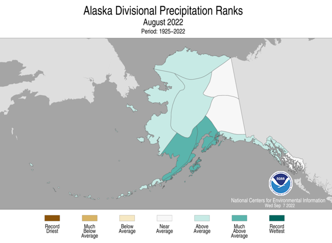
Alaska had the 10th-wettest August in the 98-year record. Much of the state was wetter-than-average, with portions of eastern Alaska and lower Panhandle experiencing near-average conditions during the month. Homer recorded its wettest August and Anchorage ranked third-wettest on record.
For the summer season, precipitation ranked in the wettest third of the record for Alaska with wetter-than-average conditions observed in the North Slope, West Coast and southern portions of the state, with parts of the Northeast interior drier than average for the season.
The January-August precipitation ranked 10th-wettest on record for Alaska, with above average precipitation observed across all but the central and northeast Interior and Aleutian regions.
Other Notable Events
Several notable flooding events, considered “1,000-year” rainfall events by the National Weather Service, occurred during the month of August:
– On August 2, parts of southern Illinois were drenched by 8 to 12 inches of rain in a 12-hour period. An area south of Newton, Illinois, recorded 14 inches of rainfall over the same period.
– On August 5, Death Valley National Park received 1.70 inches of rain, an unprecedented amount of rainfall for the area, resulting in substantial flooding and damage, and trapping visitors and staff members. This event broke the previous all-time 24-hour rainfall record of 1.47 inches recorded on April 15, 1988.
– On August 22, parts of Dallas, Texas saw more than 13 inches of rainfall within 12 hours. The governor declared a disaster for 23 Texas counties, including Dallas, after storms caused damage and devastating flash flooding.
On September 1, the Great Salt Lake, the largest saltwater lake in the Americas and eighth largest in the world, recorded its lowest water level since records began in 1847.
August had no storm activity in the North Atlantic basin, with 2022 becoming only the third year, along with 1961 and 1997, since 1950 to have no activity during the month.
Drought
According to the August 30 U.S. Drought Monitor report, about 45.5 percent of the contiguous United States was in drought, down about 5.9 percent from the beginning of August. Drought conditions expanded or intensified across portions of the Northeast, central and northern Plains, Northwest and Hawaii. Drought contracted or was eliminated across portions of the Southwest, southern Plains, central to lower Mississippi Valley, Great Lakes, parts of the Northeast and Puerto Rico. Drought covered 93.95% of the state of Hawaii – the largest extent ever recorded for that state.
Monthly Outlook
According to the August 31 One-Month Outlook from the Climate Prediction Center, much of the West to the Midwest and from the Midwest to the East Coast, as well as southeast Alaska, have the greatest chance of receiving above-normal temperatures in September, whereas the greatest chance for below-normal temperatures is projected to occur across portions of the southern Plains. Portions of the Southwest, Gulf Coast, Southeast and the Panhandle of Alaska are projected to have the greatest chance of above-normal precipitation, while the greatest chance for below-normal precipitation is expected to occur from Northwest to the Great Lakes and into New England. Drought is likely to persist across much of the West, central Plains, and Hawaii with some improvement and/or drought removal likely from the Southwest to the southern Plains, as well as across portions of Puerto Rico. Drought development is likely across small areas of the central and northern Plains, portions of the Mid-Atlantic and Hawaii.
According to the One-Month Outlook issued on September 1 from the National Interagency Fire Center, Hawaii and portions of the Northwest, Oklahoma and the Northeast have above normal significant wildland fire potential during September.
Click the link to read the release on the Wild Earth Guardians website (Jeremy Nichols):
Affected areas in Colorado, Connecticut, Texas, New Jersey, and New York are home to nearly 40 million people
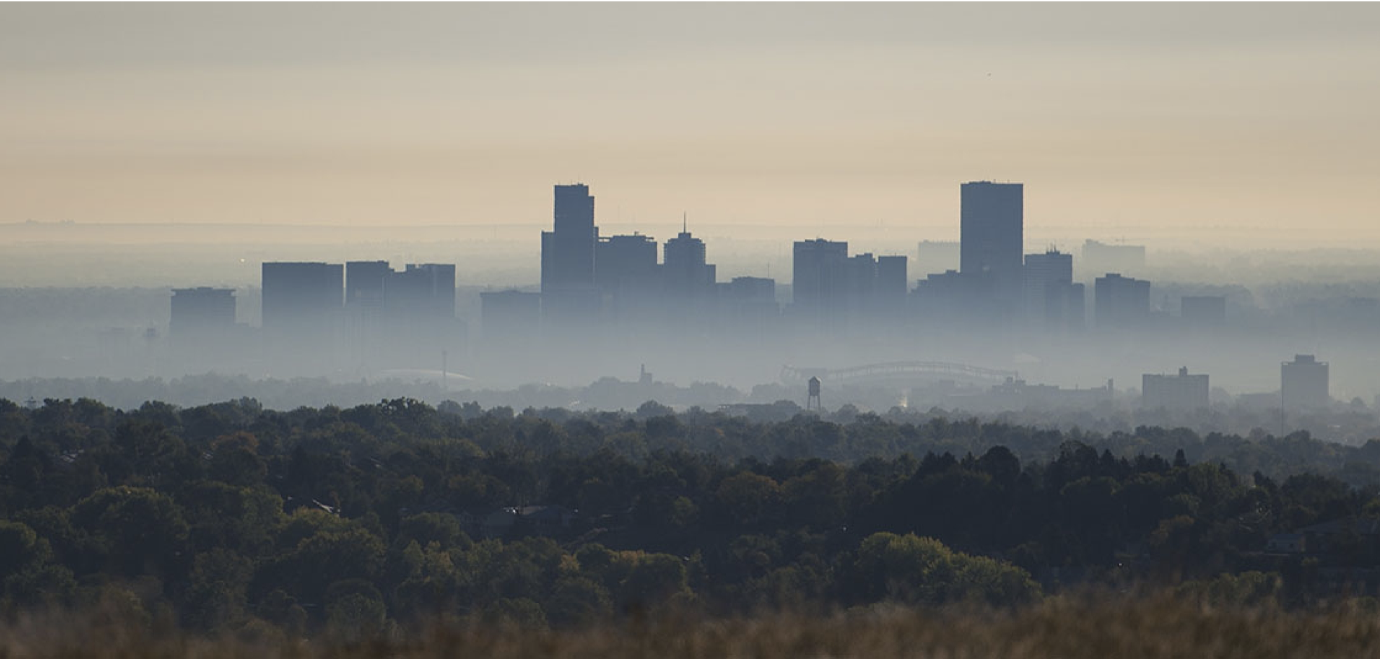
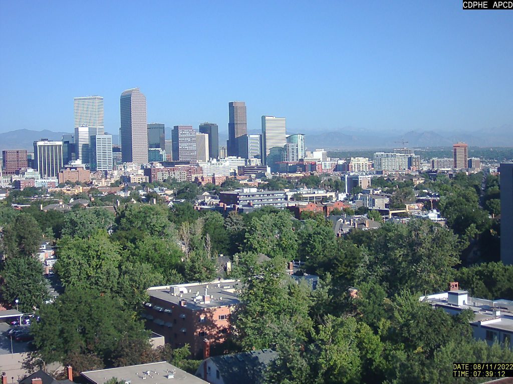
As a result of a lawsuit brought by a coalition of environmental groups, today the U.S. Environmental Protection Agency downgraded four areas across the country from a “serious” to a “severe” rating for their smog pollution. This downgrade in the ratings triggers more protective measures to reduce smog pollution.
The four areas, including the Denver Metro area, have some of the nation’s worst air quality. EPA downgraded the areas because their ground-level ozone pollution—commonly called smog—continues to exceed the levels that are safe for human health, wildlife, and plants.
“Recognizing that these areas have a severe smog problem marks an important step forward in reducing this pollution,” said Ryan Maher, an environmental health attorney at the Center for Biological Diversity. “Now it’s time for concrete plans to fix it.”
Smog pollution is linked to human health problems like asthma attacks, cardiovascular problems, and even premature death. Those most at risk include older adults, children and people who work outdoors. The harm smog does to plants can damage entire ecosystems and reduce biodiversity.
“For the more than 3.5 million people living in the Denver Metro and North Front Range region of Colorado, today’s finding gives new hope for clean air,” said Jeremy Nichols, climate and energy program director for WildEarth Guardians. “Now it’s up to Governor Polis and his administration to do the right thing and finally clean up this smoggy mess and restore healthy skies along Colorado’s Front Range.”
The four environmental groups sued the EPA in March 2022 after the agency missed its deadline to reclassify these areas from a serious to a severe rating for smog. The agreement resulting from this lawsuit required EPA to finalize the ratings for these four areas by today: the Dallas-Fort Worth and Houston-Galveston-Brazoria areas in Texas; the New York City metro areas of Connecticut, New York, and New Jersey; and the Denver-Boulder-Greeley-Fort Collins-Loveland area in Colorado.
“The 37 million people who live in these areas with unsafe levels of toxic pollution deserve clean air and immediate federal action,” said Kaya Allan Sugerman, director of the Center for Environmental Health’s illegal toxic threats program. “Today’s victory will help protect these communities from the dangers of this pollution.”
Under this agreement, EPA must also determine whether the smog ratings for Ventura County and western Nevada County in California need to be downgraded by December 16, 2022.
The downgraded ratings finalized today are part of the environmental groups’ ongoing effort to compel the EPA to protect human health and the environment from smog pollution in accordance with the requirements of the Clean Air Act.


