#Drought news (September 29, 2022): Rainfall of an inch or more in parts of #Colorado and #NE and over 2 inches in parts of #KS, and contraction of D0-D1 occurred along parts of the #RioGrande

Click on a thumbnail graphic to view a gallery of drought data from the US Drought Monitor website.

Click the link to go to the US Drought Monitor website. Here’s an excerpt:

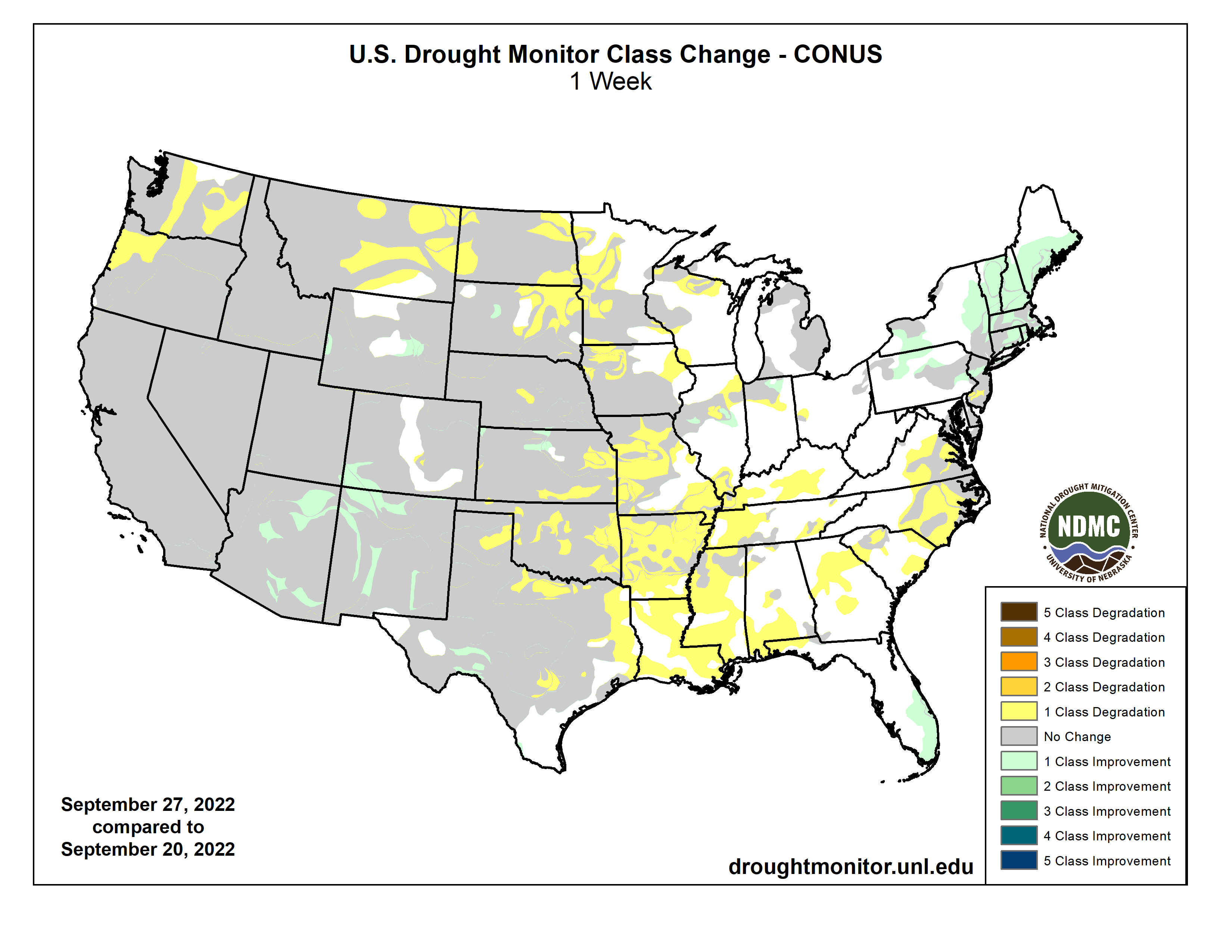
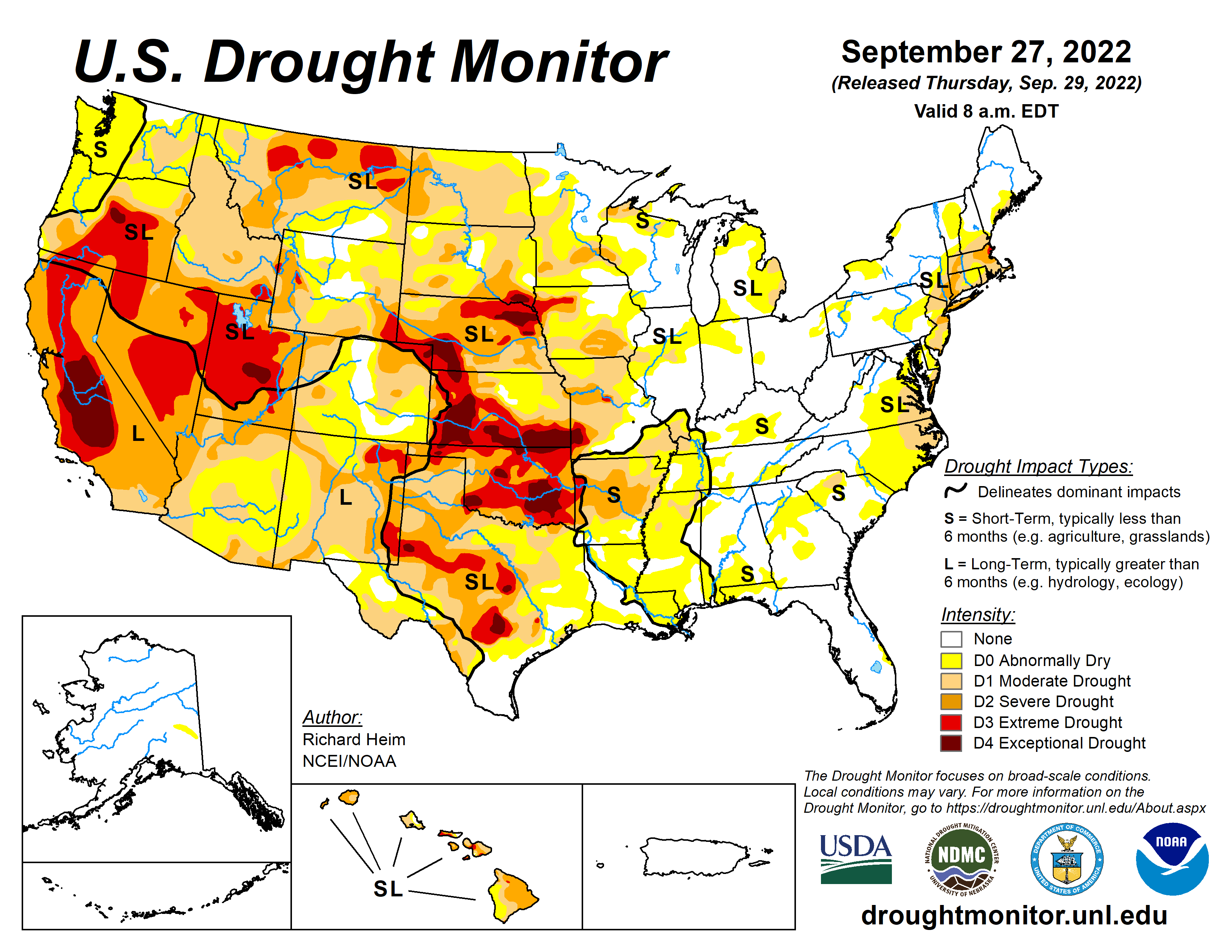
This Week’s Drought Summary

Two upper-level weather systems danced across the contiguous U.S. (CONUS) during this U.S. Drought Monitor (USDM) week (September 21-27). One partner of the pair was an upper-level low pressure trough which twirled from the West Coast to the northern Plains then migrated to the Northeast. The other partner was a high pressure ridge. As they did a kind of do-si-do, the ridge swung from the southern Plains to the western CONUS. Other players danced at the periphery – Hurricane Fiona moved across the Canadian Maritime Provinces, spreading rain over New England at the beginning of the week, while Hurricane Ian brought rain and wind to southern Florida as it bore down on the state just as the week ended. The high pressure ridge brought hot temperatures to the southern states at first, then to the West later in the period. The trough generated a storm track across the northern states, then sent a large cold front into the Southeast as the period ended. Monsoon showers joined in over the Southwest in these waning days of summer. The end result was a weekly precipitation pattern that was wetter than normal over parts of the West, southern Plains, Great Lakes, Northeast, and southern Florida. The rain missed large parts of the West, which received little to no precipitation, and much of the Plains, Mississippi to Ohio Valleys, and Southeast to Mid-Atlantic states were drier than normal as well. Temperatures for the week averaged warmer than normal over the southern Plains to Lower Mississippi Valley and across parts of the Southwest and Northwest. The week ended up cooler than normal from the northern Plains to Northeast and into parts of the Southeast. The hot temperatures and continued dry conditions, especially in the South, further dried soils. According to the U.S. Department of Agriculture (USDA), national topsoil moisture rated very short to short (dry or very dry) reached 54%, a high for the year to date and very close to the recent maximum of 56% achieved on October 18, 2020. This is the third year in a row that a peak greater than 50% has occurred. Drought and abnormal dryness contracted where it rained in the Southwest, Northeast, and southern Florida. Drought and abnormal dryness expanded where it didn’t rain, including the Northwest, Great Plains to Mississippi Valley, and Mid-Atlantic states…

High Plains

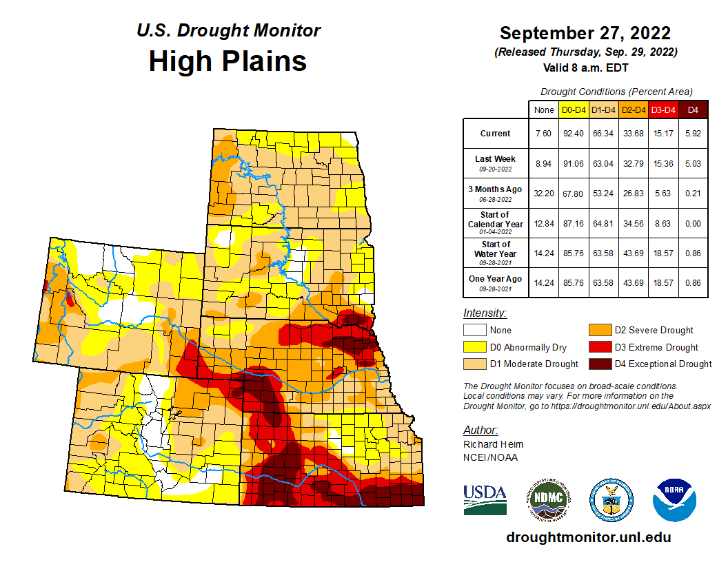
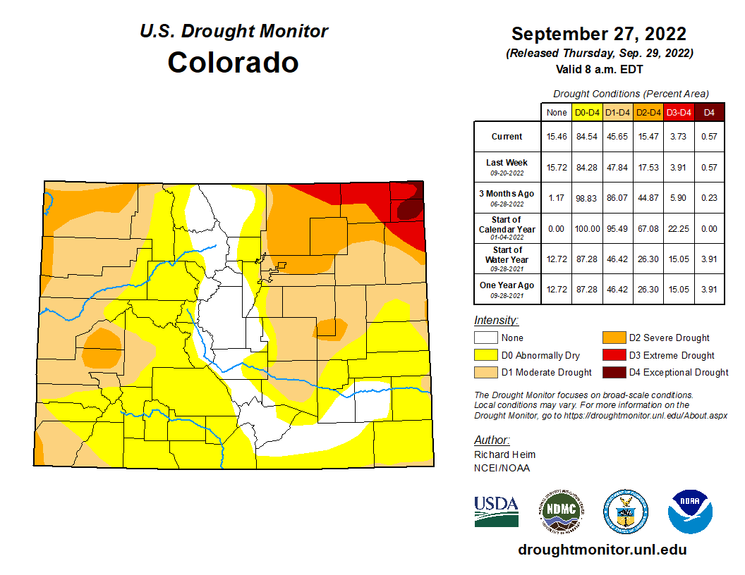
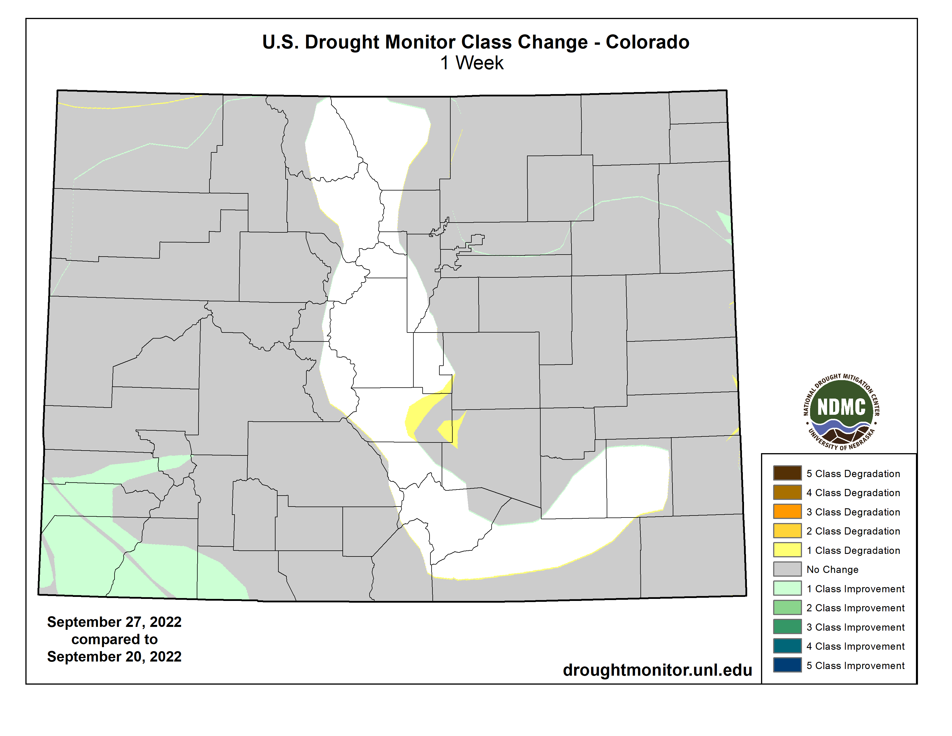
Half an inch or more of rain fell across parts of North Dakota and Wyoming, with locally an inch or more in parts of Colorado and Nebraska and over 2 inches in parts of Kansas. But most of South Dakota had less than a fourth of an inch of rain as did large parts of Nebraska and Wyoming. More than 70% of the topsoil moisture was short or very short in Kansas, Nebraska, South Dakota, and Wyoming, according to USDA statistics, with the numbers 67% in Colorado and 54% in North Dakota. According to media reports, heat and drought limited forage production in Nebraska and other drought-stricken areas, forcing cattle producers to weigh hay supplies against herd size for the winter. Many growers chopped drought-damaged crops for silage. D0-D2 were pulled back in a few parts of Wyoming, D0-D3 were trimmed in parts of Kansas and Colorado where the heaviest rains fell, and D3 was deleted in western South Dakota. But drought or abnormal dryness expanded in other parts of the High Plains region states, including North Dakota (D0-D2), Colorado (D0-D1), Nebraska (D2-D3), South Dakota (D0-D4), and Kansas (D0-D2 and D4)…

Colorado Drought Monitor one week change map ending September 27, 2022.

West

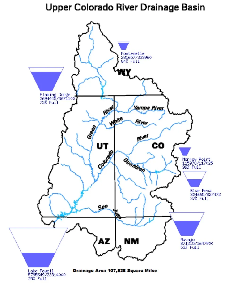
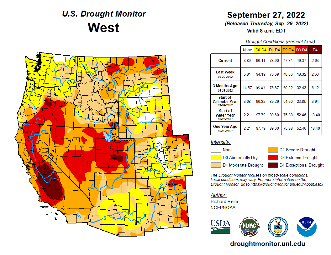
Monsoon showers dumped half an inch to locally 2+ inches of rain over parts of the Four Corners states, while a Pacific weather system gave parts of the northern Rockies half an inch to locally 2+ inches of precipitation. A few spotty areas of California, Nevada, Oregon, and eastern Montana received locally half an inch of precipitation. The rest of the West was dry. Low streams, dry soils, and a combination of hot temperatures with little to no rain prompted expansion of D0 across coastal Washington and Oregon. These conditions contributed to ponds drying up in central to eastern Washington where D1 expanded. In Oregon, most large reservoirs nearly empty to less than 10% full due to the prolonged dry weather. USDA reports indicated 95% of the topsoil moisture was short or very short in Montana, with the values 71% in Oregon and 65% in Washington. D0-D3 expanded in central to eastern Montana. Above-normal rain during this year’s monsoon season has resulted in contraction of drought in the Four Corners states. The rains this week contracted D1-D2 in Arizona and New Mexico. But 5 to 20 years of drought have brought many large reservoirs to very low levels, including Lake Powell which was still only 25% full and Elephant Butte which was 5% full. It will take several years of above-normal precipitation, and springtime melt of many winters of heavy mountain snowpack, to bring these reservoir levels back up…

South

About half an inch of rain fell across a few parts of Texas, Mississippi, and Tennessee, but otherwise the South region was dry this week. Hot and mostly dry conditions were observed this past week especially across the Arkansas-Louisiana-Texas area, with near record high temperatures recorded each day as readings neared the century mark. This marks nearly the third straight week with near cloud-free conditions, with below normal relative humidity for this time of year yielding high evaporation rates. Grounds have quickly dried out over much of the area, which has yielded an increased frequency of small wildfires especially across eastern Texas and portions of southeastern Oklahoma. In southeast Oklahoma, hydrological impacts were increasing as Broken Bow Lake was over 11 feet below conservation pool stage, with Pine Creek Lake down about 5 feet. USDA reports indicated 91% of the topsoil short or very short of moisture in Oklahoma. Rapid drying of soils has occurred in Arkansas, with the USDA statistic exploding from 40% on September 11 to 58% on September 18 and reaching 88% on September 25. According to news reports, fierce heat and drought in Arkansas have limited hay and grass growth; August rains allowed farmers to grow some hay, but farmers still do not have enough to get through the winter. Dried ponds, cracked earth, and no forage (pasture) for farm animals were common, especially in western Arkansas. D0 spread across much of Louisiana, Mississippi, and western Tennessee, with D0-D3 growing in Arkansas and D2-D4 expanding in Oklahoma. D0-D4 expanded in parts of northern, eastern, and central Texas, while contraction of D0-D1 occurred along parts of the Rio Grande River…

Looking Ahead

During the two days after the Tuesday morning cutoff time for the USDM, Hurricane Ian made landfall across Florida and an upper-level trough moved across the Northeast, with these systems bringing rain to these areas, while another Pacific trough moved into the Pacific Northwest. Dry high pressure dominated most of the rest of the CONUS. For the period September 29-October 4, the Pacific trough will move across the Pacific Northwest and northern to central Rockies, giving these regions 0.5-1.5 inches of rain with locally up to 2 inches. The remnants of Ian will be drawn over the Southeast, spreading a large area of 1-5 inches of rain across the Southeast to Mid-Atlantic states, with locally over 10 inches in parts of Florida. Ian’s rain will stretch into the eastern Tennessee Valley and southern New England, where up to an inch of rain is expected. Little to no precipitation is forecast for the rest of the CONUS where high pressure ridging will dominate. Temperatures are predicted to be warmer than normal in the West to Great Plains and cooler than normal in the Southeast to Mid-Atlantic states. For the period October 4-12, odds favor above-normal precipitation across most of Alaska and in the Four Corners states, with below-normal precipitation over the Alaska panhandle, northern portions of the West, and much of the Plains to East Coast. The West and Alaska panhandle are expected to get wetter as the period progresses. Odds favor warmer-than-normal temperatures for most of Alaska and most of the CONUS, except the period may begin cooler than normal along the East Coast.

US Drought Monitor one week change map ending September 27, 2022.

Who’s really using up the water in the American West? — Vox

Hint: water scarcity in the Western US has more to do with our diets than our lawns. Subscribe and turn on notifications 🔔 so you don’t miss any videos: http://goo.gl/0bsAjO The Western United States is currently battling the most severe drought in thousands of years. A mix of bad water management policies and manmade climate change has created a situation where water supplies in Western reservoirs are so low, states are being forced to cut their water use. It’s not hard to find media coverage that focuses on the excesses of residential water use: long showers, swimming pools, lawn watering, at-home car washes. Or in the business sector, like irrigating golf courses or pumping water into hotel fountains in Las Vegas. But when a team of researchers looked at water use in the West, they uncovered a very different story about where most Western water goes. Their findings may hold the solution to dwindling water supplies in the West.

Check out the video above to learn more, and take a look at the study that this story is centered on: https://core.ac.uk/download/pdf/32306…

Lead study author Brian Richter wrote this post on common misconceptions about water scarcity: https://www.sustainablewaters.org/hey…

For Vox coverage on water management policies on the Colorado River, which we weren’t able to cover in this story: https://www.vox.com/2022/9/23/2335709…

For coverage on just how bad the current drought is: https://www.nytimes.com/2022/02/14/cl…

For more coverage of the rotational fallowing program in the Palo Verde district in California: https://www.latimes.com/environment/s…

Check out Our World in Data for data on meat and dairy production and consumption across the world: https://ourworldindata.org/meat-produ…

Cheerful delusions about the #ColoradoRiver — @BigPivots #COriver #aridification #overdrawn22

Sunset on the Colorado River at Silt September 2022. Photo credit: Allen Best/Big Pivots

Click the link to read the article on the Big Pivots website (Allen Best):

We really would rather be getting news about another Super Bowl triumph or the end of the 55-year drought in Denver Nuggets championships. But the Colorado River is rapidly nearing total disfunction. It is the story du jour.

Rivers and streams on Colorado’s Western Slope chattered excitedly with runoff during mid-September after several days of rain, softening landscapes that had turned sullen after another hot summer.

The water was a blink of good news for a Colorado River that needs something more. It needs a long, sloppy kiss of wetness.

Hard, difficult decisions have almost entirely lagged what has been needed during the last 20 years of declining reservoir levels and rapidly rising temperatures. Hope has lingered stubbornly. After all, every batter has slumps. And maybe next winter and spring it will snow hard and long in Colorado, source of 60% of the river’s water, instead of getting unseemly warm come April and May, as has mostly been the case.

This glass half-full hopefulness has left the two big reservoirs, Mead and Powell, at roughly 25% of capacity. To prevent worse, the smaller savings accounts near the headwaters – Navajo Reservoir in New Mexico, Blue Mesa in Colorado, and Flaming Gorge on the Utah-Wyoming border – have been pilfered. Little remains to be tapped.

Even threats from the Bureau of Reclamation this year failed to spur definitive action. “We can’t keep doing this,” said Andy Mueller, general manager of the Glenwood Springs-based Colorado River Water Conservation District, a major water policy agency for the Western Slope.

Difference from average temperature in the top 300 meters (~984 feet) of the tropical Pacific between June 7 and August 1, 2022. A deep pool of cooler-than-average water (blue) spread eastward and will continue rising to the surface in coming months, feeding the current La Niña. Animation by NOAA Climate.gov, based on data from NOAA Climate Prediction Center.

Recently at the River District’s annual seminar in Grand Junction, Brendon Langenhuizen offered no hope for recovery this coming year. It will be the third La Nina in a row, he pointed out, likely producing above-average temperatures and hence below-average precipitation.

Even so-so precipitation comes up as something less. Yampa River Valley snowpack last winter was 84% of average; runoff lagged at 76%. The Gunnison River watershed figures were even worse; snowpack of 87% yielding runoff of 64%.

Dry soils have sopped up moisture, and then there is the heat. The last 12 months have been among the six warmest years in the last century in Colorado, said Langenhuisen, a water rights engineer. Summer rains the last two years have helped. Still, the reservoir levels drop, the seven basin states so far unable to agree on cuts that would match demand with supply.

It’s tempting to accuse the states of being caught up in century-old thinking. After all, they nominally operate under provisions of the 1922 Colorado River Compact. They have taken steps but they insufficiently acknowledge the shifting hydrologic reality. Instead of delivering an average 20.5 million acre-feet, as the compact assumed, the river has delivered 13 million acre-feet in the 21st century. In the last few years, it’s been worse yet, about 12 million acre-feet.

How low can it go? Mueller talked about learning to live within 9 million acre-feet, as some climate scientists have warned may be necessary. Climate scientists have built up some credibility as their forecasts have been, if anything, a tad conservative.

A scientist I talked with in Grand Junction suggested potential for an even starker future. What if the river delivers just 7 million acre-feet a year for the next two or three years?

One of my acquaintances, a county official on the Western Slope, recently confided weariness with the now familiar narrative of “drought, dust, and dystopia” on the Colorado River. Understood. We all want to see the Broncos and Avs win. More instructive may be the Denver Nuggets, who are now in a 55-year championship drought.

We will need to sort through what grasses we want and can afford, both in residential settings and in pubic areas, such as Colorado Mesa University, above. That will extend to grasses grown to feed livestock. Top, the Colorado River at Silt, Colo. on Sept. 17. Photo/Allen Best

Jim Lochhead, chief executive of Denver Water, likens the situation on the Colorado River to a bank account that has been drawn down. “And we’re looking at a zero balance with no line of credit,” he said this week at the Colorado Water Center conference in Fort Collins.

What is needed? From a perspective in Colorado, Lochhead argues for a stronger, more assertive federal role. Lochhead was for many years a lawyer based in Glenwood Springs who represented Colorado in river issues.

Map credit: AGU

Everybody that depends upon Colorado River water from northeastern Colorado to Los Angeles and San Diego will have a role, he says. Denver for example, wants to crowd out grass from medians and incentivize turf removal.

Lower-basin states use about twice as much as the upper basin states, and there the cuts must be more radical. Lochhead wants to see the federal government, through the Bureau of Reclamation, more assertively force the lower-basin states to make those hard decisions. Federal authority over water entering Lake Mead has been upheld by the U.S. Supreme Court, he points out, and he suggests the agency may use that power after the November election.

The broad theme will be reducing water used for low-value grasses. That takes in suburban lawns but also the water-greedy grasses grown for livestock, including corn and alfalfa. Hard choices, but they must be made. What more warning do we need?

Brad Udall: Here’s the latest version of my 4-Panel plot thru Water Year (Oct-Sep) of 2021 of the Colorado River big reservoirs, natural flows, precipitation, and temperature. Data (PRISM) goes back or 1906 (or 1935 for reservoirs.) This updates previous work with @GreatLakesPeck. Credit: Brad Udall via Twitter

Half of world’s bird species in decline as destruction of avian life intensifies — The Guardian

A Vermilion Flycatcher along the Laguna Grande Restauration Site in Baja California, Mexico. Photo: Claudio Contreras Koob

Click the link to read the article on The Guardian website (Phoebe Weston). Here’s an excerpt:

State of the World’s Birds report warns human actions and climate crisis putting 49% in decline, with one in eight bird species under threat of extinction

The State of the World’s Birds report, which is released every four years by BirdLife International, shows that the expansion and intensification of agriculture is putting pressure on 73% of species. Logging, invasive species, exploitation of natural resources and climate breakdown are the other main threats.

Globally, 49% of bird species are declining, one in eight are threatened with extinction and at least 187 species are confirmed or suspected to have gone extinct since 1500. Most of these have been endemic species living on islands, although there is an increase in birds now going extinct on larger land masses, particularly in tropical regions. In Ethiopia, for example, the conversion of grassland to farmland has caused an 80% decrease in endemic Liben larks since 2007. Just 6% of bird species globally are increasing.

Since 1970, 2.9 billion individual birds (29% of the total) have been destroyed in North America. The picture is just as bleak in other parts of the world – since 1980, 600 million birds (19%) have been destroyed in Europe, with previously abundant species such as the common swift, common snipe and rook among those slipping towards extinction. Europe’s farmland birds have shown the most significant declines: 57% have disappeared as a result of increased mechanisation, use of chemicals and converting land into crops. In Australia, 43% of abundant seabird species have declined between 2000 and 2016.

Dr Stuart Butchart, chief scientist at BirdLife International, said: “We have to stop these declines and start getting on track for recovery. Our future, as well as the world’s birds, depends on it. If we continue to unravel the fabric of life, we’re going to continue to place our own future at threat.”