As you begin to descend towards Echo Lake on the Mestaa’ėhehe Pass road, Mt Evans and its barely visible road come into focus. Photo credit: Colorado Bike Maps
Click the link to read the article on the Aurora Sentinel website (Mead Gruver). Here’s an excerpt:
The U.S. government has joined a ski resort and others that have quit using a racist term for a Native American woman by renaming hundreds of peaks, lakes, streams and other geographical features on federal lands in the West and elsewhere…
The changes announced Thursday capped an almost yearlong process that began after Haaland, the first Native American to lead a Cabinet agency, took office in 2021. [Deb] Haaland is from Laguna Pueblo in New Mexico.
The Native American Rights Fund, a nonprofit legal organization, welcomed the changes.
“Federal lands should be welcoming spaces for all citizens,” deputy director Matthew Campbell said in a statement. “It is well past time for derogatory names to be removed and tribes to be included in the conversation.”
Other places renamed include Colorado’s Mestaa’ėhehe (pronounced “mess-taw-HAY”) Pass near Mestaa’ėhehe Mountain about 30 miles (48 kilometers) west of Denver. The new name honors an influential translator, Owl Woman, who mediated between Native Americans and white traders and soldiers in what is now southern Colorado.
Sunset from the western shore of Antelope Island State Park, Great Salt Lake, Utah, United States.. Sunset viewed from White Rock Bay, on the western shore of Antelope Island. Carrington Island is visible in the distance. By Ccmdav – Own work, Public Domain, https://commons.wikimedia.org/w/index.php?curid=2032320
Click the link to read the article on the Science Magazine website (Eli Kintisch). Here’s an excerpt:
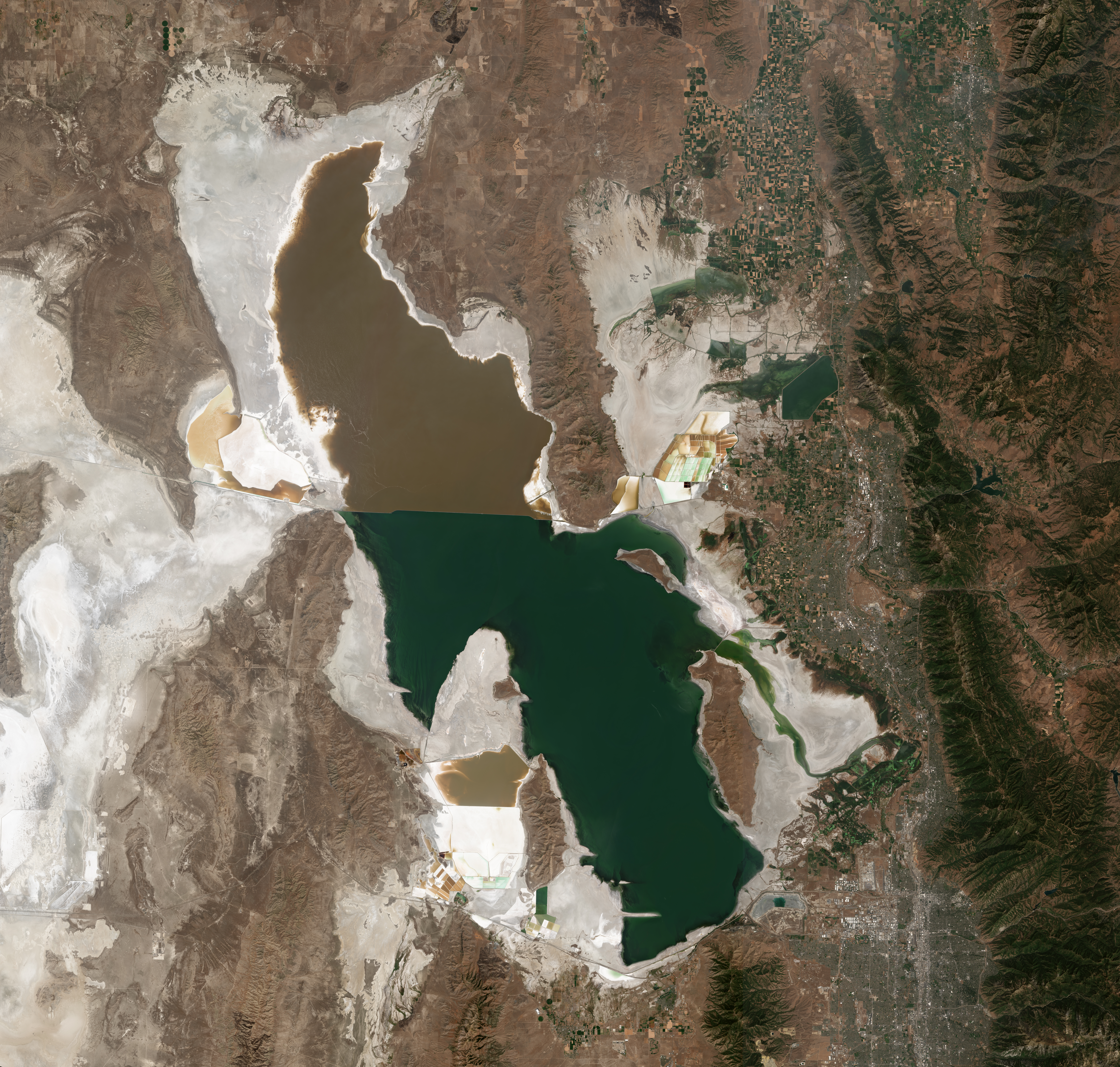
Utah’s Great Salt Lake is smaller and saltier than at any time in recorded history. In July, the U.S. Geological Survey (USGS) reported that the world’s third-largest saline lake had dropped to the lowest level ever documented. And last week researchers measured the highest salt concentrations ever seen in the lake’s southern arm, a key bird habitat. Salinity has climbed to 18%, exceeding a threshold at which essential microorganisms begin to die. The trends, driven by drought and water diversion [ed. and aridification influenced by Climate Change], have scientists warning that a critical feeding ground for millions of migrating birds is at risk of collapse.
“We’re into uncharted waters,” says biochemist Bonnie Baxter of Westminster College, who has been documenting the lake’s alarming changes. “One week the birds are gone from a spot we usually see them. The next week we see dead flies along the shore. And each week we have to walk further to reach the water.”
After years of inaction, the prospect of a dying lake, plus the risk of harmful dust blowing from the dry lakebed, is galvanizing policymakers to find ways of restoring water to the shrinking lake.
Satellite photo of the Great Salt Lake from August 2018 after years of drought, reaching near-record lows. The difference in colors between the northern and southern portions of the lake is the result of a railroad causeway. The image was acquired by the MSI sensor on the Sentinel-2B satellite. By Copernicus Sentinel-2, ESA – https://scihub.copernicus.eu/dhus/#/home, CC BY-SA 3.0 igo, https://commons.wikimedia.org/w/index.php?curid=77990895
The Great Salt Lake is really two lakes, divided in 1959 by a railroad causeway. Over time, the northern arm, which has few sources of fresh water, became saltier than the southern arm, which is fed by three rivers. Historically, salinity in the northern arm has hovered around 32%—too salty to support more than microorganisms—and about 14% in the southern arm. Although the southern part is about four times saltier than seawater, it supports a vibrant ecosystem characterized by billions of brine shrimp and brine flies, which feed on photosynthetic cyanobacteria and other microorganisms. Birds, in turn, devour prodigious numbers of flies and shrimp when they arrive at the lake to nest, molt, or rest during migrations. A diving waterbird called the eared grebe, for example, needs 28,000 adult brine shrimp each day to survive.
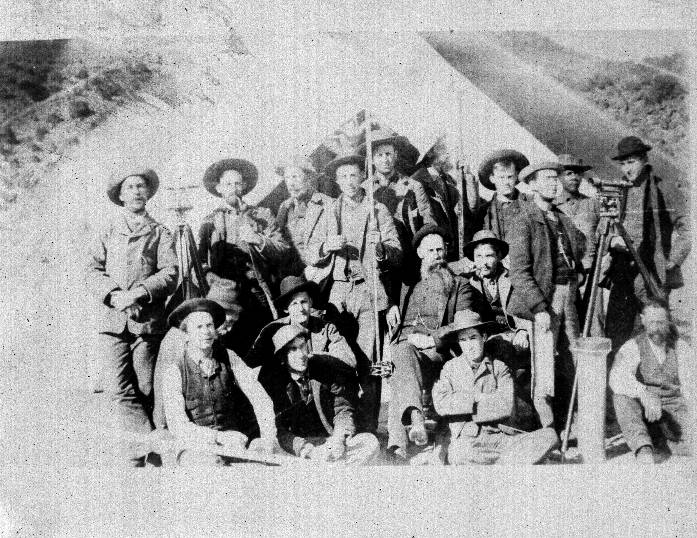
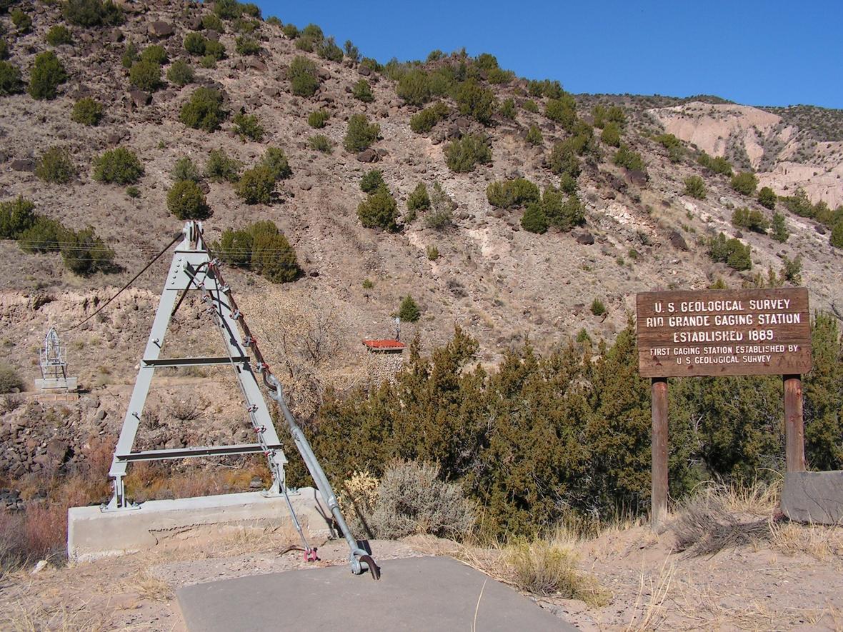
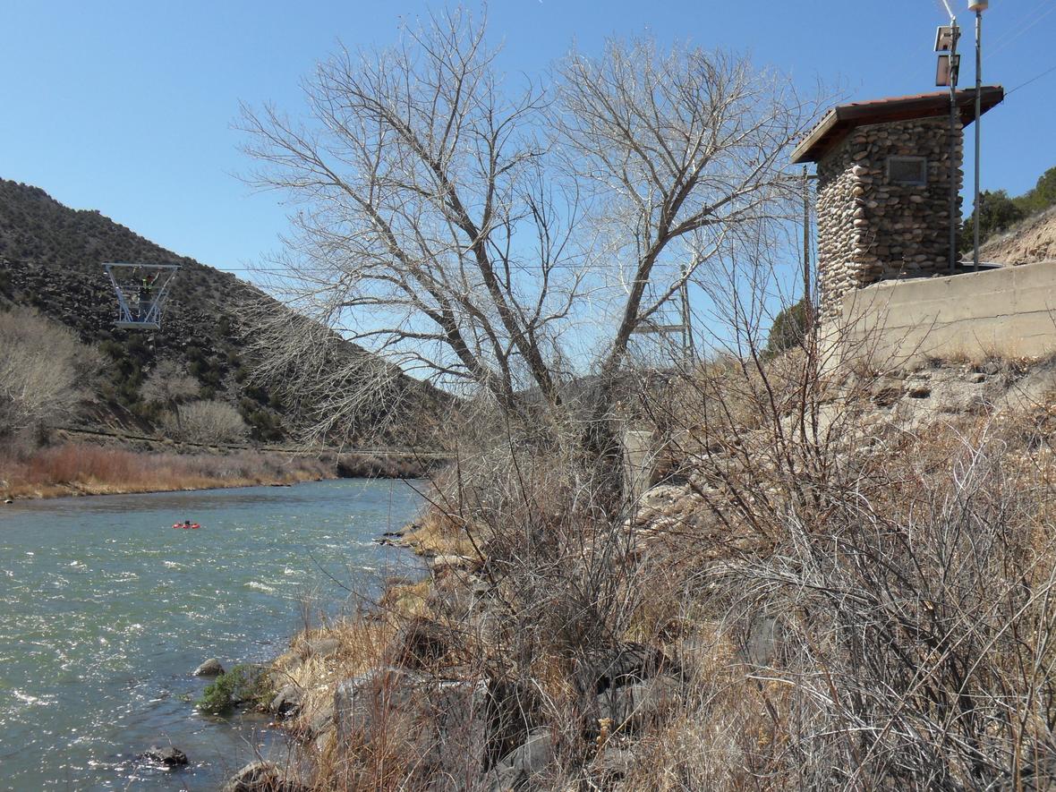
There’s no evidence that John Wesley Powell, the second director of the U.S. Geological Survey, ever made it to this stretch of the Rio Grande back in the winter of 1888-89, when he dispatched a crew to the site to establish the nation’s first river flow measurement site…
The first USGS streamgage, at Embudo, New Mexico, just turned 125 years old. Public domainThe first USGS streamgage, at Embudo, New Mexico, just turned 125 years old. Public domain
In the world of U.S. water management, this narrow strip where the river funnels between high bluffs is historic. Powell, most famous as the first person to survey the Grand Canyon, had realized that the ambitions of the continent’s European immigrants spreading west across North America were running up against an arid reality that Easterners failed to understand. Collective effort would be needed to confront the region’s aridity…Powell realized, and one of the first things the young nation needed was to measure how much water there was in the rivers.
Powell’s young agency, founded a decade before, dispatched a crew to Embudo in the winter of 1888-89 to try to figure out how to do that. The initial team that winter was led by Frederick Newell, who 13 years later became the founding director of the U.S. Reclamation Service, the predecessor to today’s U.S. Bureau of Reclamation, and the agency responsible for the dams and irrigation systems that changed the western U.S. forever.
The first experiment, done on the Rio Grande at Embudo, just north of Española, was simple. They surveyed the channel’s depth and width, then built a simple pontoon boat and floated downstream. A bit of simple arithmetic – the river’s cross section multiplied by the speed of the flowing water – gave their first measurement of the volume of water flowing past Embudo.
Big Thompson Canyon before and after September 2013 flooding. Photo credit: Flywater.com
Click the link to read the article on the Fort Collins Coloradoan website (Mile Blumhardt). Click through and read the whole article with video and photos. Here’s an excerpt:
Deaths, damage caused by 2013 flood in Colorado
– At least nine people were killed
– The flood covered 4,500 square miles, or the size of more than 10 Rocky Mountain National Parks
– The damage estimate reached nearly $4 billion
– More than 19,000 people were evacuated and 3,000 had to be rescued
– 26,000 homes were damaged or destroyed
– 200 businesses were destroyed and 750 were damaged
– 485 miles of road were damaged or destroyed statewide, including U.S. Highway 34 in the Big Thompson Canyon
– 50 major bridges were damaged
– There were 65 flash flood warnings
Storm pattern over Colorado September 2013 — Graphic/NWS via USA Today
“The surprise of the 2013 flood was that it happened that time of year,” state climatologist Russ Schumacher said in a Coloradoan story on the eight-year anniversary of the flood. “Events like this that come to mind tend to come in late July and early August during monsoon storms or in May and June with intense thunderstorms.”
Click the link to read the article on the Pagosa Springs Sun website (Dorothy Elder). Here’s an excerpt:
At its Sept. 6 meeting, the Pagosa Springs Sanitation General Improvement District (PSSGID) Board of Directors heard an update about the district’s major pump replacement project that relayed that the pumps are, so far, a success. The project, which began during the last week of June, was meant to address a history of broken parts and inefficiencies within the system. At this point, the new pumps are achieving flows “near to what is desired,” the agenda brief explains. However, the project has come with costs, with a total cost to date of $780,000, according to the brief. Town Manager Andrea Phillips explained that the project “may be slightly over budget” due to having to order some additional parts and retrofits.
However, the town will seek reimbursement from a $400,000 grant from the state, Phillips explained…
Some of these improvements include additional pretreatment that “may be needed in order to ensure that the longevity of the pumps continue,” such as a grit removal system or moving to an automated bar screen, Phillips explained.
City Spokesperson Todd Barnes said the city will decide between three ways to move forward: asking for a rehearing at the Court of Appeals, appealing to the Colorado Supreme Court or applying for a new permit. The project will now cost the city an additional $126 million because of the delays and increase in labor and steel costs.
“While we are disappointed with the court’s ultimate decision, we appreciated that the court acknowledged Thornton’s lengthy and active efforts to work with Larimer County and its citizens as we went through the permit process,” said Barnes…
The Larimer County Planning Commission voted to deny the permit on May 16, 2018. In response, Thornton worked to address the concerns raised by the Commission. Thornton then submitted a revised application, which included changing the preferred route: a corridor approach that was recommended by the Commission. With the new edits, the Commission recommended to the Board of Commissioners to approve the project. However, the Board voted unanimously to deny the application on Feb. 11, 2019, saying the project did not meet seven of the 12 criteria. Thornton took the decision to the District Court, claiming the board abused its discretion in denying Thornton’s application. While the Board said that seven of the criteria weren’t met, the District Court ruled that there were only three instances with competent evidence to support the Board’s conclusion. Thornton appealed the decision at the Court of Appeals, who dealt a blow to Thornton, but recognized the Board’s abuse of power.
“Although we agree with Thornton that the Board exceeded its regulatory powers in several respects, we ultimately affirm its decision to deny the permit application,” they wrote in the opinion…
The Larimer Board of County Commissioners also recommended Thornton use the river, but Thornton said that running that water through the City of Fort Collins would degrade the water. The Court of Appeals said the method would also require modification of the water decree and ruled in favor of Thornton. As well, that court noted that making that request is outside of the Board’s power. Additionally, the Court of Appeals ruled the Board abused its discretion by suggesting Thornton’s potential use of eminent domain weakened its application because it was “disfavored by property owners.” The Court said that can’t be considered in the 1041 process.
“It is clear that the Board may not consider Thornton’s potential use of eminent domain during its 1041 review,” the judges wrote.
Thornton Water Project route map via ThorntonWaterProject.com