Soils influence water quality, and they are critical to plant growth. However, it has been difficult to predict how plant growth and water quality would change in the wake of wildfires. Now, a team of Colorado investigators has devised new methodology to enable such predictions. The research is published in Applied and Environmental Microbiology, a journal of the American Society for Microbiology.
“To make practical predictions about recovery, we had to use a modern artificial intelligence tool called statistical learning,” said John Spear, professor of Civil and Environmental Engineering at Colorado School of Mines. “When we fed data about the microbes and nutrients into this model, we were able to predict how soil is changed by fire far more accurately.”
Spear emphasized that combining information on the types and quantities of both microbes and nutrients increased accuracy. Another intriguing discovery was that including microbiota that are uncommon in soil—those that constituted less than 1 percent of the microbiome—was critical to the predictions’ accuracy.
“This apparent contradiction is a fascinating outcome of our study and runs contrary to the common wisdom that if we measure 99 percent of what’s living in soil, we’ll have a great sense of how that soil will behave,” said first author Alexander S. Honeyman, who defended his PhD at Mines earlier this month.
The investigators were also able to predict water quality by analyzing the microbiome for species that affect both soil regeneration and downstream waters, said Spear, who added that the methodology may lead to a better understanding of both terrestrial and aquatic ecosystem recovery post-wildfire.
In the study, “We went out to two active wildfires in Colorado in 2018 and 2019, and collected soil shortly after the smoldering stopped,” said Spear. “This was as simple as shoveling soil into a bucket. We returned to the same sites for three summers [2018, 2019, and 2020], collecting more samples, and followed up as the landscape recovered from the black of burn to the green of new growth.”
Back in the lab, the investigators measured soil carbon, nitrogen and other important molecules. They also took the census of the microbiome—the species present, and the quantities of each in the soils.
“The trick,” said Spear, “was to do this over and over in a thorough fashion for three years, generating a dataset of more than 500 soil samples. Then, we wanted to see if the pattern of recovery of soil after fire could be predicted from this unique dataset, using statistical learning.”
The methodology worked, despite the fact that the dataset is quite diverse—representing different severities of wildfire and various soil types and seasons. “That’s good news for our approach, because [the methodology] appears to work on many different conditions of soil,” said Spear.
The research was motivated by Honeyman’s decade of experience as a volunteer firefighter, and having lost his home to a Colorado wildfire in 2010. This experience raised important questions for him. Would soil recover nutrients that had been lost in a fire? The investigators also wanted to know whether water quality would be renewed. “We asked ourselves how we could describe recovery in a way that’s actually useful to land managers,” said Spear, noting that, “our forest service coauthors, who are land managers, really liked this work.”
As climate change contributes to more frequent fires, it is critical that we understand how to manage the recovery of burned soil, particularly in the western U.S., said Spear.
Spear noted that the methodology could likely also be applied to agriculture to boost food production “even while using less water and less fertilizer, thus saving money.”
The Weaver Ditch as it winds through Sopris Park in Carbondale. While the ditch is an amenity for the community, the water in the ditch comes directly out of the Crystal River, which is often stressed from lack of water. Some Carbondale residents irrigate their lawns and landscaping with the town’s ditches, like the Weaver Ditch, that flow through town. A new unified outdoor watering standard would not apply to those who use ditch water, but they still are encouraged to comply. CREDIT: HEATHER SACKETT/ASPEN JOURNALISM
In an effort to unify the Roaring Fork watershed, a local agency has developed valley-wide outdoor watering standards that its board members hope will be adopted by municipal water providers.
Last week the Ruedi Water and Power Authority board, which is made up of representatives from local towns and counties, gave its unanimous support to a set of unified permanent watering standards. The standards are focused on time of day and day of week for outdoor watering and would apply to any residential or commercial customer receiving municipal water from the city of Aspen, town of Basalt, town of Carbondale, city of Glenwood Springs, Snowmass Water & Sanitation District and Mid-Valley Metropolitan District.
The proposed schedule would limit outdoor watering to between 6 p.m. and 9 a.m. three days a week. Properties with odd-numbered addresses could irrigate on Wednesdays, Fridays and Sundays; even-numbered properties could water on Tuesdays, Thursdays and Saturdays. No outdoor watering would be allowed on Mondays. Water providers could still enact more stringent restrictions depending on local conditions in their areas; the standards are intended to be a new baseline.
“If we can make this change, the idea that (watering restrictions) change from year to year to year will go away,” said Rachel Richards, Aspen City Council and RWAPA board member. “It’s going to be much easier and less expensive than having to tell people every year what the rules are this summer.”
The new watering standards were developed with the help of a project accelerator grant from WaterNow Alliance, which according to its website is a network of water leaders advancing climate resilient water strategies, and Boulder-based environmental advocacy group Western Resource Advocates. Outdoor watering of lawns and landscaping is often the largest water use category for local water providers; for the city of Aspen, outdoor irrigation represents about 70% of total water use.
The proposed schedule would result in water savings because watering would happen during the coolest periods of the day, peak demands would be reduced and one day a week of no watering would allow storage to be refilled, according to a memo from WaterNow Alliance and WRA.
“The three-day-per-week schedule is relatively easy to communicate to residents and other water users and it can be easily programmed into all types of irrigation controllers,” the memo reads.
The valley-wide watering standards were an outgrowth of the regional water efficiency plan, said RWAPA Executive Director April Long.
“We learned from the providers that were part of that plan that they still really needed some unified messaging about outdoor water use,” Long said. “We realized we don’t even have common ground to tell people exactly what to do because we have so many drought stages, and restrictions implemented in different ways. We actually need some baseline standards so we can provide a common message that’s not confusing for all of our residents.”
There are some exceptions to the standards. Outdoor watering can still occur any time of day with a handheld hose or drip irrigation. And those who irrigate with water from a ditch, like many residents in the town of Carbondale, are not subject to the standards, but are encouraged to comply.
The standards lay out penalties for violation, including a written warning for a first violation, and fines increasing to $500 for a fourth violation. But proponents will focus solely on an education campaign for the first season before issuing warnings or fines.
The next step is for Long to present the watering standards to each of the participating municipalities and get them approved by elected officials.
Dam removal is expected to improve the health of the Klamath River, the route that Chinook salmon and endangered coho salmon take from the Pacific Ocean to their upstream spawning grounds, and from where the young fish return to the sea. The US Federal Energy Regulatory Commission issued an order surrendering the dam licenses and approving removal of the dams. The project has long been a goal of several Native tribes whose ancestors have lived off the salmon for centuries but whose way of life was disrupted by European settlement and the demand for rural electrification in the 20th century.
“The Klamath salmon are coming home,” Joseph James, chairman of the Yurok tribe, said in a statement. “The people have earned this victory and with it, we carry on our sacred duty to the fish that have sustained our people since the beginning of time.”
Climate change and drought have also stressed the salmon habitat; the river has become too warm and too full of parasites for many fish to survive.
According to the U.S. Department of Agriculture (USDA) National Water and Climate Center’s snowpack report, the Wolf Creek summit, at 11,000 feet of elevation, had 5.6 inches of snow water equivalent as of 1 p.m. on Wednesday, Nov. 16. The Wolf Creek summit was at 108 percent of the Nov. 16 snow pack median. The San Miguel, Dolores, Animas and San Juan river basins were at 112 percent of the Nov. 16 median in terms of snowpack.
River report
Stream flow for the San Juan River at approximately noon on Nov. 16 was 75.1 cubic feet per second (cfs), according to the U.S. Geological Service (USGS) National Water Dashboard. These numbers are down from a nighttime peak of 123 cfs at 1:15 a.m. on Nov. 16. This reading is also down from last week’s reading of 141 cfs at noon on Nov. 9.
On Nov. 10, the Pagosa Area Water and Sanitation District (PAWSD) Board of Directors heard an update from William Canter- bury, of Canterbury Construction Management Services, on his assessment of the costs of the Snowball water treatment plant expansion. Canterbury began his assessment by highlighting that PAWSD is currently in a construction man- ager at risk (CMAR) arrangement for the construction of the plant, with PCL Construction Services Inc. as the construction firm. He explained that he performed an independent cost estimate on the elements of the expansion.
Canterbury stated that, to his assessment, the project is indeed a $37 million job instead of a $25 million job, although he indicated that there are some elements of the project that he still wanted to speak with PCL about and that his final report would not be finished until the next week.
“Overall … they’re pretty much on the mark,” Canterbury stated. “I don’t see anything that jumps out at me.”
Enthusiasm in Imperial. Screenshot of the Imperial Valley Press front page November 17, 1922.
Click the link to read the article on the InkStain website (Eric Kuhn and John Fleck):
The world outside of Bishop’s Lodge in New Mexico got its first glimpse of the nascent Colorado River Compact on in the days following the Nov. 16, 1922, meeting as Commerce Secretary Herbert Hoover briefed reporters on the barest details of what was transpiring behind closed doors.
For the first time, folks back home in the seven Colorado River Basin states saw the emergence of the idea of an “upper division” – Utah, Colorado, Wyoming, and New Mexico – and a “lower division” – Arizona, Nevada, and California.
“Definite allotment of an equal amount of the waters of the river was agreed upon between the two divisions,” wire stories out of Santa Fe reported, “and provision was made for the summoning of a second commission some years hence for the equitable division of the unallotted water, in light f the then increasing knowledge and increasing need.”
“Preference in rights for the use of water is to be established to agriculture,” reporters were told, “and none of the existing rights in the basin are disturbed.”
Southern Pacific passenger train crosses to Salton Sea, August 1906. Photo via USBR.
ENTHUSIASM IN IMPERIAL
For the Imperial Valley, vulnerable to flooding in the river’s southern reaches, the news was good. “The commission agreed upon the extreme agency for immediate erection of control work to protect the Imperial Valley from floods,” the wire dispatches continued.
The reaction in Imperial Valley was immediate.
“Protection of Valley is Assured”, the Imperial Valley Press headlined.
IN ARIZONA, A LACK OF ENTHUSIASM
But in addition to enthusiasm, there were warnings of the struggles to come.
“I wish to warn California right now,” Arizona Governor-elected George W.P. Hunt said in a telegram to the Arizona Republic, “and you can make it as strong as horse-radish that has just been ground, that while I am governor I am going to stick up for Arizona’s rights.”
Arizona, Hunt said, should be entitled to half of the Colorado River’s flow. “The center of the river is a state line,” Hunt said. “The center of the river is where the rights of one state cease and those of the other begin.” The seeds of decades of conflict between Arizona and the other states of the basin were being sown, even as the Compact’s final drafting was not complete.
For years, several nonprofits, government agencies, citizens and other stakeholders have spearheaded attempts to improve the Animas River. But now, it appears these stakeholders are interested in merging their respective efforts under an SMP, which could better organize projects and increase opportunities for grant funding.
“I think we could be entering a new phase of the Animas River,” Laura Spann, programs coordinator with Southwestern Water Conservation District, said. “(An SMP) might be a way to build a broader vision with all the groups.”
Stakeholders are in the very early stages, just gauging whether there’s public interest to develop an SMP for the Animas. In other parts of the state, the plans have been used to improve fish habitat, increase river access and restore riparian areas.
“These plans are specifically designed to look at the needs of a river basin, or part of a river basin, as it relates to recreational and environmental needs,” Warren Rider, coordinator of the Animas Watershed Partnership, which is leading the SMP process, said. “About a year ago, we started to think now could be a good time.”
[…]
After organizers complete interviews with stakeholders, they’ll draft a “scope of work” document that outlines what the SMP could cover. From there, it’ll depend if there’s enough community support for the plan to progress into actual work on the ground. While a lot remains to be determined when it comes to the Animas River’s SMP, one thing is clear: creating one may have incredible benefits, especially as climate change and drought take their toll on environmental conditions.
What’s the cheapest, quickest way to reduce climate change without roiling the economy? In the United States, it may be by reducing methane emissions from the oil and gas industry.
Methane is the main component of natural gas, and it can leak anywhere along the supply chain, from the wellhead and processing plant, through pipelines and distribution lines, all the way to the burner of your home’s stove or furnace.
Once it reaches the atmosphere, methane’s super heat-trapping properties render it a major agent of warming. Over 20 years, methane causes 85 times more warming than the same amount of carbon dioxide. But methane doesn’t stay in the atmosphere for long, so stopping methane leaks today can have a fast impact on lowering global temperatures.
That’s one reason governments at the COP27, the 2022 United Nations climate change conference in Egypt, have focused on methane as an easy win in the climate battle.
So far, 130 countries, including the United States and most of the big oil producers other than Russia, have pledged to reduce methane emissions from oil and gas by at least 30%. China has not signed but has agreed to reduce emissions. If those pledges are met, the result would be equivalent to eliminating the greenhouse gas emissions from all of the world’s cars, trucks, buses and all two- and three-wheeled vehicles, according to the International Energy Agency.
There’s also another reason for the methane focus, and it makes this strategy more likely to succeed: Stopping methane leaks from the oil and gas industry can largely pay for itself and boost the amount of fuel available.
Capturing methane can pay off
Methane is produced by decaying organic material. Natural sources, such as wetlands, account for roughly 40% of today’s global methane emissions. But the majority comes from human activities, such as farms, landfills and wastewater treatment plants – and fuel production. Oil, gas and coal together make up about a third of global methane emissions.
In all, methane is responsible for almost a third of the 1.2 degrees Celsius (2.2 degrees Fahrenheit) that global temperatures have risen since the industrial era.
Unfortunately, methane emissions are still rising. In 2021, atmospheric levels increased to 1,908 parts per billion, the highest levels in at least 800,000 years. Last year’s increase of 18 parts per billion was the biggest on record.
Among the sources, the oil and gas sector is best equipped to stop emitting because it is already configured to sell any methane it can prevent from leaking.
Methane leaks and “venting” in the oil and gas sector have numerous causes. Unintentional leaks can flow from pneumatic devices, valves, compressors and storage tanks, which often are designed to vent methane when pressures build.
Nearly all of these emissions can be stopped with new components or regulations that prohibit routine flaring.
Making those repairs can pay off. Global oil and gas operations emitted more methane in 2021 than Canada consumed that entire year, according to IEA estimates. If that gas were captured, at current U.S. prices – $4 per million British thermal unit – that wasted methane would fetch around $17 billion. The IEA determined that a one-time investment of $11 billion would eliminate roughly 75% of methane leaks worldwide, along with an even larger amount of gas that is wasted by “flaring” or burning it off at the wellhead.
Motivating U.S. producers to act has been the big hurdle.
The Biden administration is aiming for an 87% reduction in methane emissions below 2005 levels by the end of the decade. To get there, it has reimposed and strengthened U.S. methane rules that were dropped by the Trump administration. These include requiring drillers to find and repair leaks at more than 1 million U.S. well sites.
The U.S. Inflation Reduction Act of 2022 further incentivizes methane mitigation, including by levying an emissions tax on large oil and gas producers starting at $900 per ton in 2024, increasing to $1,500 in 2026. That fee, which can be waived by the Environmental Protection Agency and doesn’t affect small producers or leaks below 0.2% of gas produced, is based on the social cost to society from methane’s contribution to climate damage.
Customers are also putting pressure on the industry. Regulatory indifference by the Trump administration to U.S. methane flaring and venting led to cancellation of some European plans to import U.S. liquefied natural gas.
Reducing methane isn’t always straightforward, though, particularly in the U.S., where thousands of oil companies operate with minimal oversight.
A company’s methane emissions aren’t necessarily proportional to its oil and gas production, either. For example, a 2021 study using data from the EPA found Texas-based Hilcorp Energy reporting nearly 50% more methane emissions than ExxonMobil, despite producing less oil and gas. Hilcorp, which specializes in acquiring “late life” assets, says it is working to reduce emissions. Other little-known producers have also reported large emissions.
Investor pressure has pushed several publicly traded companies to reduce their methane emissions, but in practice this sometimes leads them to sell off “dirty” assets to smaller operators with less oversight.
Unlike carbon dioxide, which lingers in the atmosphere for a century or more, methane only sticks around for about a dozen years. So, if humans stop replenishing methane stocks in the atmosphere, those levels will decline.
A review of methane leaks in the Permian Basin shows the big impact that some regions can have.
Researchers found that gas and oil operations in the Permian, in west Texas and New Mexico, had a leakage rate estimated at 3.7% in 2018 and 2019, before the pandemic. A 2012 study found that leakage rates above 3.2% make climate damage from using natural gas worse than that from burning coal, which is normally considered the biggest climate threat.
Methane leaks used to escape detection because the gas is invisible. Now, the proliferation of satellite-based sensors and infrared cameras makes detection easy.
Companies such as GTI Energy’s Veritas, Project Canary and MiQ have also launched to assist natural gas producers in reducing emissions and then verifying the reductions. At that point, if leaks are less than 0.2%, producers can avoid the federal fee and also market their output as “responsibly sourced” gas.
Click the link to read the article on the KUNC website (Alex Hager). Here’s an excerpt:
As the once-mighty Colorado dries up at the hands of a changing climate, communities that rely on it are starting to feel the pinch. Many large cities in the Southwest are well-positioned to weather the growing crisis, but some smaller ones have a perilous front row seat as the shrinking river threatens to cut off their water supply completely. Page is one of them. [Tobyn] Pilot pointed down towards Glen Canyon Dam, a 700-foot-tall concrete behemoth that looms large in the background.
“There’s a pipeline that’s bored through the cliff of Glen Canyon,” Pilot said. “It comes to the edge, just past us here, and goes straight up into another pipeline that goes up to our water plant.”
That pipe brings water up from the river hundreds of feet below, and carries it to the taps in homes, hotels and restaurants in this tourist town. But the system is under threat. Page pulls its water from Lake Powell, the nation’s second-largest reservoir…If the reservoir drops below Page’s current intake, water would flow through a set of backup pipes known as the “river outlet works.” Originally designed as a channel for extra water during high-flow times, those tubes, which are lower than the existing pass-through, could soon be the only way for water to make it through the dam. Without a fix, Lake Powell could have dropped low enough to cut off Page’s drinking water supply completely.
The back of Glen Canyon Dam circa 1964, not long after the reservoir had begun filling up. Here the water level is above dead pool, meaning water can be released via the river outlets, but it is below minimum power pool, so water cannot yet enter the penstocks to generate electricity. Bureau of Reclamation photo.
The river tried its best in 2022 but didn’t get much help. Total precipitation at the headwaters was low, again. Temperatures at the headwaters were much higher than normal, again. Consequently, total runoff came near historic lows, and daily flow hovered below the 25th percentile for most of the year. Again. Following are summary data documenting the historical records of climate and flows in the White River Basin.
Peak runoff in the White River also occurs earlier in the year. Historically, peak runoff occurred in early June, but peak is trending earlier. April runoff is increasing and June runoff is trending downward (data not shown). Longer periods of low flow in the summer provide favorable conditions for algae growth, increase stress on fish, and also decrease available irrigation and municipal water supplies.
The data presented here document global and regional trends toward a hotter, drier world. Updated climate models predict that climate conditions in the White River Basin 30 or 40 years from now will resemble the present brush and sandstone regime of southeastern Utah (Talsma et al, 2022; NCA 2018).
On a positive note: we haven’t seen a big algae bloom for the past couple years. It’s not at all clear what happened to stifle the algae. Low water and higher water temperatures, such as we are seeing in the basin, generally encourage algae growth. A plausible assumption is that efforts by the Conservancy Districts and the White River Alliance are paying off. People have stepped up to try to reduce nutrients going into the river and to reduce insecticide application. A final report from the USGS algae study group is still pending, and some particulars, such as point sources of nutrients, are not available. However, we can take some hope that people are making a positive difference in the health of the river.
Study reach shown within the context of the mainstem Columbia River and major tributaries (a). Pink and green polygons highlight available spawning area for Grande Ronde River summer steelhead and Snake River fall Chinook Salmon evolutionarily significant units (ESUs). Colored points in (b) correspond to significant cold-water refuges (CWRs) between Bonneville Dam and the Snake River confluence. (c) The mean daily temperature for modeled portion of mainstem Columbia River reservoirs (gray-scale lines) and CWRs (colored lines corresponding to points in [b]).
Click the link to read the release on the USGS website (Jason Dunham):
The importance of thermal refuges in a rapidly warming world is particularly evident for migratory species, where individuals encounter a wide range of conditions throughout their lives. In this study, we used a spatially explicit, individual-based simulation model to evaluate the buffering potential of cold-water thermal refuges for anadromous salmon and trout (Oncorhynchus spp.) migrating upstream through a warm river corridor that can expose individuals to physiologically stressful temperatures. We considered upstream migration in relation to migratory phenotypes that were defined in terms of migration timing, spawn timing, swim speed, and use of cold-water thermal refuges. Individuals with different migratory phenotypes migrated upstream through riverine corridors with variable availability of cold-water thermal refuges and mainstem temperatures. Use of cold-water refuges (CWRs) decreased accumulated sublethal exposures to physiologically stressful temperatures when measured in degree-days above 20, 21, and 22°C. The availability of CWRs was an order of magnitude more effective in lowering accumulated sublethal exposures under current and future mainstem temperatures for summer steelhead than fall Chinook Salmon. We considered two emergent model outcomes, survival and percent of available energy used, in relation to thermal heterogeneity and migratory phenotype. Mean percent energy loss attributed to future warmer mainstem temperatures was at least two times larger than the difference in energy used in simulations without CWRs for steelhead and salmon. We also found that loss of CWRs reduced the diversity of energy-conserving migratory phenotypes when we examined the variability in entry timing and travel time outside of CWRs in relation to energy loss. Energy-conserving phenotypic space contracted by 7%–23% when CWRs were unavailable under the current thermal regime. Our simulations suggest that, while CWRs do not entirely mitigate for stressful thermal exposures in mainstem rivers, these features are important for maintaining a diversity of migration phenotypes. Our study suggests that the maintenance of diverse portfolios of migratory phenotypes and cool- and cold-water refuges might be added to the suite of policies and management actions presently being deployed to improve the likelihood of Pacific salmonid persistence into a future characterized by climate change.
Click the link to read the article on the InkStain website (Eric Kuhn and John Fleck):
On Nov. 16, 1922, the representatives of the seven Colorado River Basin states and federal lead negotiator Herbert Hoover settled what is, from today’s perspective, the most important element, of the Colorado River Compact.
Holed up a century ago at Bishop’s Lodge outside Santa Fe, New Mexico, they had come to agreement on dividing the river into “upper” and “lower” basins, with some water for each, a feature taken for granted in river management in the 21st century but new to their thinking a century ago. But they were at a stalemate on how much water the upper states would be obligated to send to the lower states.
Before adjourning the previous day’s meeting, Hoover had put a compromise proposal on the table – the Upper Basin would deliver 75 million acre-feet every consecutive ten years with a four million acre-feet minimum annual delivery. This was ten million more than the Upper basin’s 65 million acre-feet offer and seven million less than the 82 million acre-feet that the Lower Basin said they would accept.
During the 18th meeting the commissioners from both basins accepted Hoover’s offer and went far beyond that, agreeing to a set of broad principles that could be included in the compact.
THE FANTASY OF A SURPLUS
They also made one major change of direction. Through the end of the 17th meeting, the Commission had been focused on dividing the entire river. Carpenter had first suggested a 50/50 split at the Yuma gage (near the border with Mexico). In the most recent meetings, their focus had turned to dividing the river at Lee’s Ferry. But late Wednesday night, in executive session, or via discussions Hoover had with the individual caucuses, the commission decided to divide the river three ways – a piece for the Lower Basin, a piece for the Upper Basin, and a third surplus pool that would be apportioned at a future date.
Hoover put it this way – “In our discussions yesterday we got away from the point of view of a fifty-fifty division of the water. We set up an entirely new hypothesis. That we make, in effect, a preliminary division pending the revision of this compact. The seven and a half million acre-feet of flow rights are credited to the South, and seven and a half will be credited to the North, and at some future day a revision of the remaining water will be made or determined.”
The technical basis for a three-way split was as follows: The estimated water supply available from the river below Yuma was believed more than 20 million acre-feet annually. Arthur Powell Davis estimated that existing and future consumptive uses in the Upper Basin would total 6.5 million acre-feet annually. In the Lower Basin his estimate was 7.45 million acre-feet, 5.1 on the mainstem and 2.35 on the tributaries.
Allocating 7.5 million for each basin would cover their needs and leave a surplus of 5-6 million acre-feet to be doled out in the future. The language the Commission discussed showed that their intent was not to divide water, but rather to limit appropriations within each basin – “during the term of this compact appropriations may be made in either division with equality of right as between them up to a total of 7,500,000 acre-feet per annum for each division.”
Grand River Ditch July 2016. Photo credit Greg Hobbs.
EXPANDING “THE BASIN”
The Commission discussed ten basic principles including defining the Colorado River Basin as the hydrologic drainage basin plus places within a basin states, but outside the drainage area where water could be legally used. This made it clear that under a compact transbasin (transmountain) projects would be legal. This was crucial to negotiators for Utah, Colorado, and California. The Commission also agreed on the priority of uses. Domestic (broad definition) and agricultural uses would be superior to power generation and all superior to navigation purposes. It also agreed that the burden of a future treaty obligation would be equally shared between each basin.
The commissioners couldn’t agree on detailed language for all the principles, but still the 18th meeting ended on a euphoric note. They all agreed that it was time to for Chairman Hoover to appoint a drafting committee. Hoover appointed Carpenter, Steven B. Davis, Arizona Legal Advisor Richard Sloan, California Legal Advisor R.T. McKisick, and Reclamation Service Chief Counsel Attomar Hamele. Carpenter asked that Hoover be an ex-officio member of the committee and Hoover accepted.
The drafting committee met on the afternoon of November 16th and most of the day on both November 17th and 18th.
Herbert Hoover presides over the signing of the Colorado River Compact in November 1922. Members of the Colorado River Commission stood together at the signing of the Colorado River Compact on November 24, 1922. The signing took place at the Palace of the Governors in Santa Fe, New Mexico, with Secretary of Commerce Herbert Hoover presiding (seated). (Courtesy U.S. Department of Interior, Bureau of Reclamation)
The Federal Energy Regulatory Commission’s decision will see licenses of the four dams transferred from the PacifiCorp energy company — a subsidiary of Warren Buffet’s Berkshire Hathaway — to the Klamath River Renewal Corporation, a nonprofit entity created to oversee the dam removal, and to the states of California and Oregon. The vote marks the final major hurdle for what will be the largest dam removal project in the nation’s history, officials said. The $500-million demolition has been championed by environmental organizations, commercial fishing groups and tribes that spent 20 years fighting for the river’s restoration.
“The Klamath salmon are coming home,” Yurok Tribe Chairman Joseph James said in a statement. “The people have earned this victory and with it, we carry on our sacred duty to the fish that have sustained our people since the beginning of time.”
Officials said the dam removal process could begin as soon as next year, with the smallest dam, Copco 2, slated to be removed first. Deconstruction of the remaining three dams will occur in early 2024, with all four dams removed by the end of that year. FERC commissioners on Thursday described the decision as “momentous,” “historic” and “the culmination of years of work.”
“Some people might ask why, in this time of great need for zero-emissions energy, why are we, why is the licensee, agreeing to remove the dams?” Chairman Richard Glick said during the meeting. “First, we have to understand this doesn’t happen every day. … A lot of these projects were licensed a number of years back when there wasn’t as much focus on environmental issues, and some of these projects have a significant impact on the environment and a significant impact on fish and other wildlife.”
Indeed, salmon populations in the once-teeming Klamath Basin have dwindled to almost nothing in large part because of the dam-blocked habitat. In an April letter to FERC, the Pacific Fishery Management Council noted that the Klamath River once produced the “third-most prolific salmon runs of all river systems in the lower 48 states.” Today, those runs are at only a “small fraction of their historical average,” the council said, with two of the runs listed under the federal or California endangered species acts, or both. Mark Bransom, chief executive of the Klamath River Renewal Corp., said the dam removal will not only create conditions that will allow fish to move up and down the river freely, but will also help improve water-quality conditions on the river, including toxic algal blooms in stagnant reservoirs.
In the halls of the Colorado State Capitol drinking fountains are in easy reach, and grabbing a quick drink of cool, clear, odorless water is an automatic act.
But just minutes away, in dozens of industrialized neighborhoods in North Denver, Commerce City and unincorporated Adams County, many homeowners and apartment dwellers never drink their tap water.
Tens of thousands of people in this area have been exposed to contaminated water over the years. Convincing them finally that their water is now safe to drink is a tough sell.
In a Commerce City bungalow on Kearney Drive, Armando Guardiola and his family are sitting in a small kitchen, eating posole from brightly colored bowls. The water served for this meal did not come from their tap. Instead, it came from a large, pale blue five-gallon jug perched on the edge of the sink.
It has been this way since Guardiola, a retired railway worker, and his parents moved into this bungalow in 1982.
Maria Guardiola cleans up after dinner. In her and her husband’s bungalow in Commerce City, the pale blue water jugs supply the family with drinking water. They don’t drink tap water. Credit: Jerd Smith, Fresh Water News
Their tap water, he says, as his brother and sister interpret, is full of minerals that leave a residue everywhere. Sometimes it has an odor or a strange taste. The family’s water comes from the South Adams Water and Sanitation District and meets all the state standards for water quality and safety. But this is no comfort to the people who live here.
“They used to say, don’t drink the water,” Guardiola said. “Then, they came out about 15 years ago and said it was better. But we don’t trust this. A lot of people here have skin rashes. They have lost their hair. It has been a continuous problem.”
Two water bills
Parts of north Denver, south Adams County, and Commerce City have a legacy of water contamination that dates back more than half a century and is tied to aging lead service lines, in Denver, and various industrial activities farther north.
Wave after wave of pollutants have been discovered in this area, from contaminants that leaked from the Rocky Mountain Arsenal in the 1980s, to contamination from the local oil refinery whose lights dot the skyline at dawn and dusk.
Now, so-called forever chemicals, also known as PFAS, short for per- and polyfluoroalkyl substances, have been discovered in the groundwater in Commerce City and have been linked to firefighting foam used up until 2018 at the nearby Denver Fire Training Academy, according to the Colorado Department of Public Health and Environment.
The City of Denver disputes that finding. It declined an interview request, citing potential litigation.
The South Adams Water and Sanitation District (SAWSD) says it must spend $45 million to $70 million to build a new treatment plant to remove this PFAS from its raw water.
Will it ever end, residents ask. They can’t answer that question.
Instead, many opt to pay two water bills: one at the local water filling station, where they often spend $10 to $50 a week to buy water for drinking and cooking, for watering plants and caring for their pets. This is in addition to their monthly water and sewer bills from the local utility, in this case the South Adams Water and Sanitation District. Utility costs vary depending on location and water use.
One of several commercial water stations in Commerce City and unincorporated Adams County where residents fill jugs with water for drinking and cooking because they don’t trust the tap water. Credit: Jerd Smith, Fresh Water News
Sacrifice zones
Armando’s brother Beto says there is little hope in the community that their tap water will ever be drinkable.
“To go back to the tap water we think is risky,” Beto said. “We’ve been told it’s good. We’ve been told it’s bad. We hope what happened in Jackson, Mississippi, doesn’t happen here,” referring to the decades-long problems with Jackson’s water system that finally collapsed earlier this year after it was inundated by flood waters.
Patricia Ferrero heads Protégete, an environmental justice initiative housed within Conservation Colorado.
“Honestly it all comes down to trust” Ferrero said. “I don’t know if there is one thing that would re-establish trust with these communities. Industry is so close to home. There is too much evidence that it is a sacrifice zone.”
Cultivando, another environmental justice group which is focused on Commerce City, recently launched a tap water testing program funded by the University of Denver. It has signed up 30 homeowners in the area, who have agreed to allow specially trained community members to come into their homes and gather water samples to have them privately tested. These residents get their water from various sources, including some from privately owned wells.
Residents from Commerce City and Adams County gather at Our Lady Mother of the Church in October to learn about private water testing being offered for free by environmental justice group Cultivando and funded by the University of Denver. Credit: Jerd Smith, Fresh Water News
Once results are in, the activists will consider what next steps need to be taken. This could mean pushing for better water treatment or new indoor piping, or, if results confirm that the water is, in fact, safe to drink, looking at how they can work alongside the state health department and water providers to reassure residents on this point. In this way, the community organizers hope to begin rebuilding trust in the local water along with the government agencies and water utilities charged with protecting their water and their health.
Mike Wireman, a former national groundwater specialist at the U.S. Environmental Protection Agency, is running the Commerce City testing program for Cultivando.
“We have heard for some time, from residents who live in parts of Commerce City, that their water tastes bad, smells bad, feels bad. Bacteria can cause that. We know they have a problem, but I don’t believe that it is related to the water that leaves the Commerce City treatment plant. It gets back in somewhere between the water treatment plant and the homes,” Wireman said.
The problem may be inside these older homes. “The houses that were built were not constructed with the best materials. They were not $500,000 homes. They were built to accommodate industrial workers,” he said.
In addition to neighborhood activists, lawmakers have also taken note. In 2021, at lawmakers’ request, the Colorado Department of Public Health and Environment created an environmental justice action task force in an effort to forge better relationships with communities whose water quality has been harmed by industrial contamination.
“We take these issues very seriously,” said Nicole Rowan, head of CDPHE’s Water Quality Division.
The state has also begun working with the City of Denver to oversee the removal of PFAS from soils around the Denver Fire Training Academy in Adams County. How long the cleanup might take isn’t clear. But Rowan said some mitigation work at the site has begun.
Generations of distrust
For the South Adams Water and Sanitation District, the legacy of contamination is a powerful, cultural constant. The district has built two treatment plants and is planning a third to deal with the issues, which stem both from industrial activities and naturally occurring minerals present in groundwater.
The discovery of PFAS in its groundwater wells in 2018 added another major item to its long list of industrial woes. The district immediately shut down wells that were too contaminated to salvage at the time, and began aggressively treating its other wells, as well as blending with clean water purchased from Denver, to meet federal PFAS safety standards. According to its 2022 Consumer Confidence Report, the district has been successful in meeting all federal and state water quality standards.
The district has spent millions of dollars and has some of the most sophisticated on-site testing equipment in the state, if not the country, according to Kipp Scott, SAWSD’s manager. Its high-tech labs allow the utility to test its raw water and treated water almost continuously to ensure it is safe. But new PFAS standards that are close to being finalized by the federal government will mean more has to be done.
Alan Frey, a PFAS analyst at South Adams Water and Sanitation District, checks levels Nov. 4 in Commerce City. Credit: Jerd Smith, Fresh Water News
Scott remains deeply worried that the plume of contamination moving from the fire academy toward his district’s wells won’t be stopped before it gets any closer. In the interim, the district is spending some $8 million a year to buy clean surface water supplies from Denver Water to mix with its own, to ensure it can continue to deliver clean water until the contamination is removed.
Equally distressing is the community’s skepticism about the district’s efforts to deliver clean water to them, Scott said.
“It’s been a public relations nightmare,” he said.
The district is also plagued with naturally occurring hard water, which damages plumbing and can cause skin rashes and hair loss in some. Last year, the district built a $60 million water-softening plant that now delivers water that is much softer to residents.
Many of its customers still don’t know the water has been improved or do not believe it.
Theresa Friess, SAWSD’s public affairs coordinator, was hired to help educate and engage customers.
“It’s been a hard conversation, in part because it’s hard to hear that our customers feel this way,” said Friess. “But we have tried to increase our outreach and we are having more conservations with non-English speaking residents as well.”
The district has hosted tours and open houses, and has had various government officials meet with residents and publicly drink the water that flows from the taps in an effort to prove it is safe.
To date, there is little if any belief among nearly two dozen residents across north Denver, Commerce City and unincorporated Adams County interviewed by Fresh Water News that the water won’t make them sick.
“We have been drinking this water for years,” said one woman at a meeting convened by Cultivando in Commerce City last month on the private tap water testing program. Speaking through an interpreter, she said, “They think they can come in here and take one drink of water to convince us it is safe? What does that prove?”
Are your pipes okay?
In Denver’s Elyria, Swansea and Globeville neighborhoods, Denver Water has been working since 2019 to replace tens of thousands of lead service lines to protect its customers from lead contamination. Testing had shown that lead was leaching from the pipes into the water that reached the tap. The work is going on across the city, including such neighborhoods as Hilltop and Washington Park. Lead service lines are more likely to be an issue for homes built before 1951.
The agency replaced the old lead service lines in front of Tony Garcia’s Elyria house two years ago.
Garcia, a well-known historian and executive director of Su Teatro, and others in the neighborhood are happy about the remediation project. Some even drink the water now. But the utility is still almost 10 years away from having all the city’s lead service lines replaced, even with a new federal infrastructure grant to speed the process.
Raymond Gallegos water his lawn in Elyria in North Denver. Gallegos, whose water service lines have been replaced by Denver Water to help eliminate lead contamination, said he trusts the water now. Credit: Jerd Smith, Fresh Water News
Garcia still uses filters provided by Denver Water, and the utility still tests his water periodically. Denver Water spokesman Todd Hartman said the ongoing testing is part of its lead monitoring program. For many of these older homes, the water may still contain lead, leaching not from the main delivery lines, which are lead-free, or from the customer-owned service lines Denver Water is replacing, but from the aging plumbing systems within the homes themselves. No amount of lead is safe to drink.
Garcia doesn’t drink the tap water and has no plans to do so. If his home’s pipes need to be replaced, he said, it will have to be done by the next homeowner or someone else.
CDPHE’s Rowan said her agency is researching whether some of its grant money could be accessed by homeowners to be used for in-home pipe replacement, but isn’t clear yet whether that is possible.
What the neighborhood has endured, not just with lead contamination but also with air and groundwater pollution, “would not be tolerated in other communities,” Garcia said.
In addition to the ongoing risk to public health, cost is a major concern, for residents and the water districts and state agencies charged with keeping the water safe.
On a recent Friday morning, student chef Paul Tyrell is filling up several of the ever-present five-gallon pale blue jugs at a private water station in Commerce City. His pregnant partner sits in the front seat as he hauls the empty jugs out of the back seat, fills them at the water station, and lugs them to the car.
Commerce City resident Paul Tyrell fills his family’s water jugs here every week because he and his wife say the water in their apartment makes them feel sick. Credit: Jerd Smith, Fresh Water News
Here five gallons of water costs $1.50, or 30 cents a gallon. Tyrell will fill up all his containers once a week, at a cost of $7 to $10. If he could use his apartment’s tap water from SACWD, it would cost less than 5 cents a gallon. The district charges $5.24 for the first 12,000 gallons used.
“I wish we would have better water,” Tyrell said. “We don’t use the water in our apartment because it makes us feel sick.”
Who pays
Denver Water has raised residential water rates to help pay for its lead remediation work, in addition to issuing bonds and using cash on hand to cover for the $168 million overall project cost. It has also been approved for a $76 million federal infrastructure grant to help accelerate the work.
In South Adams County, the federal government paid for the district’s primary water treatment plant, completed in 1989, as part of the Superfund cleanup at the Rocky Mountain Arsenal.
But since 2018, the district has been forced to uses its own money, and some state grants, to fund the $3 million price tag on new water treatment processes along with testing equipment related to the PFAS contamination.
Residents are paying just over $4.50 a month additionally to cover the cost of the new water softening plant, but Scott says the district doesn’t believe they should have to pay to cover the cost of the new $45 million to $70 PFAS treatment plant. The district plans to apply for federal infrastructure improvement funds to get that done.
“Our residents should not have to bear this cost for the additional treatment we are going to have to put in place. But the new plant is going to be less expensive than purchasing Denver water over the long haul.”
It’s not just water bills that are expensive. Residents are often approached by sales people suggesting the water is so unsafe that they need to buy expensive in-home treatment systems and filters.
South Adams Water Quality Supervisor Kevin Pustulka said he recently went out to a home where a woman was preparing to buy a $20,000 in-home softening system that she didn’t need. “Please don’t,” he told her.
His message to everyone else: “The next time someone offers to sell you an in-home water device, call me.”
Olga Gonzalez hopes they do. She is executive director of Cultivando and has watched people in these North Metro communities struggle for years. That things may be changing is possible, she said, but her level of skepticism remains high.
“We are seeing them [the CDPHE and South Adams] ask what our communities need and be transparent and explain things in a way residents can understand. I feel hopeful that finally community members will be heard. We have been very clear that we don’t want these agencies to just check boxes and say they have been in touch with the community.”
For the environmental justice activists on the ground, after years of battling industrial pollution and institutional indifference, they are convinced the way to deliver safe tap water and to convince residents that it won’t make them ill, lies in rebuilding trust between residents and the government.
“In the end, we don’t want to be residents’ go-to,” Gonzalez said. “We want them to go to the people who are paid to protect them, and take care of their health.”
This project was made possible, in part, by funding from the Colorado Media Project.
Jerd Smith is editor of Fresh Water News. She can be reached at 720-398-6474, via email at jerd@wateredco.org or @jerd_smith.
Pressure is increasing on the controlled environment agriculture (CEA) sector–and costs are on the rise, too. For indoor farmers, the drive to be as energy efficient as possible is nothing new.
The sector has been shaped by various developments, including an increased awareness of climate change, tighter environmental legislation and government schemes incentivising renewable energy. Keeping energy consumption down helps companies deliver against the UN’s sustainable development goals (SDG) and internal environmental, social and governance (ESG) targets. This helps generate real financial value and increases business resilience–especially in the current social climate. Photo credit: Intelligent Growth Solutions
Governor Polis and the Global Business Development Division of the Colorado Office of Economic Development and International Trade (OEDIT) formally announced today that Intelligent Growth Solutions (IGS), a Scotland-based agricultural infrastructure company supplying vertical farms to growers has selected Loveland, Colorado for expansion.
“This is a great addition to Colorado’s strong, innovative, and climate-smart agriculture sector. Plus this expansion creates over 100 jobs in Loveland, helps our economy thrive, and contributes to a great future for agriculture,” said Gov. Jared Polis.
IGS designs and produces vertical farming equipment that enables indoor growing, eliminates the need for pesticides and fungicides, and reduces water consumption by recycling up to 95%. Because no arable land is required, these systems can also be used to reduce the carbon footprint of food production by locating farms closer to the point of consumption or production. Opening a base of operations in Loveland will allow the company to better support North American consumers, the company’s fastest-growing market.
“The forward-looking approach to economic development within the city of Loveland and the state of Colorado fits perfectly with Intelligent Growth Solutions’ purpose of working with growers to help deliver sustainable food security,” said David Farquhar, CEO of IGS. “The location is within easy reach of a huge market as well as supply chain partners and is a great place for our people — and their families — to live, with 300 days of sunshine and just 30 miles from Rocky Mountain National Park.
“The location of our North American headquarters is a pivotal decision in our evolution as a market leader. We are confident that our new Loveland base will allow our rapidly growing business to continue to expand and thrive on a global platform, as we deliver vertical farming infrastructure to enable real farmers to grow an expanding range of crops reliably, profitably and sustainably because we give them total control of the weather for the first time: designed in Scotland manufactured in Colorado.”
The company also chose Loveland for the strong, skilled labor pool. Overall, IGS expects to create 114 net new jobs at an average annual wage of $98,991, which is 183% of the average annual wage in Larimer County. Positions will include engineers, supply chain managers, customer support, human resource and legal managers, as well as roles in marketing and sales.
“IGS’ technology, mission and people are a perfect fit for the ag-tech ecosystem that continues to flourish across our region and in Loveland,” said City of Loveland Economic Development Director, Kelly Jones. “Northern Colorado provides tremendous value to a diverse range of industries and we are proud of this truly collaborative, regional effort to bring this innovative company, as well as high paying jobs, to the area.”
“Innovative companies like IGS are building on Colorado’s strong agricultural heritage to create a future-thinking ag tech industry that will feed communities and support a thriving economy across our state. We are pleased to see Loveland become IGS’s North American headquarters and look forward to celebrating future accomplishments,” said Patrick Meyers, OEDIT Executive Director.
“We couldn’t be happier to welcome Intelligent Growth Solutions to Colorado—their innovative thinking and accomplishments in sustainability make them a great fit for the state,” said Metro Denver EDC president, Raymond H. Gonzales. “Agriculture is both an economic driver and a part of history for Colorado, and as advances in ag-tech continue to evolve, we want our state front and center in innovative and sustainable solutions in this industry. The addition of Intelligent Growth Solutions will help bring this vision to reality.”
The State of Colorado will provide up to $2,758,845 in performance-based Job Growth Incentive Tax Credits to IGS, referred to as Project Sprout during the OEDIT review process, over an 8-year period. The company currently has 220 employees, one of whom is already in Colorado. In addition to Colorado, the company considered Washington and Massachusetts.
In early November, the U.S. Supreme Court agreed to hear a case brought by the Navajo Nation that could have far-reaching impacts on tribal water rights in the Colorado River Basin. In its suit, the Navajo Nation argues that the Department of Interior has a responsibility, grounded in treaty law, to protect future access to water from the Colorado River. Several states and water districts have filed petitions opposing the tribe, stating that the river is “already fully allocated.”
The case highlights a growing tension in the region: As water levels fall and states face cuts amid a two-decade-long megadrought, tribes are working to ensure their water rights are fully recognized and accessible.
On average, 15 million acre-feet of water used to flow through the Colorado River every year. For scale, one acre-foot of water could supply one to three households annually. A century ago, states reached an agreement to divide that water among themselves. But in recent decades, the river has supplied closer to 12 million acre-feet. Scientists say water managers in the basin need to plan for closer to 9 million acre-feet per year, a 40 percent decrease in a water source that supports 40 million people, due to climate change and aridification.
No states have made plans to accommodate this drop. Meanwhile, tribal nations are legally entitled to between 3.2 and 3.8 million acre-feet of ground and surface water from the Colorado River system.
There are 30 federally recognized tribes in the river’s basin, and 12 of them, including Navajo Nation, still have at least some “unresolved” rights, meaning the extent of their rightful claims to water have yet to be agreed upon.
Grist / Jessie Blaeser / Amelia Bates
Ultimately, Indigenous nations in the Colorado River Basin could be serious power brokers in crucial water negotiations to come — but they face historical, legal and practical obstacles. The Navajo Nation, for example, has rights to almost 700,000 acre-feet of water annually across New Mexico and Utah, along with unresolved claims in Arizona. But, because of a lack of infrastructure, up to 40 percent of Navajo households don’t have running water. For the Navajo Nation and other tribes with allocations in the basin, building and improving infrastructure means providing citizens with access to a fundamental human right: water.
But tribal water use is taken out of state allocations, meaning the more water tribes use, the less states have. It also means that states have less incentive to work with tribal leaders or recognize pending water rights claims. This conflict is not new. It has been built into a century of policies that have excluded and divested from Indigenous nations. Read Next
Tribes often hold senior water rights, meaning their allocations are the last to be cut in a shortage, and states in the basin are beginning to reckon with this fact. A fundamental shift in how the river is governed — to a system that acknowledges tribes’ sovereignty and gives them greater say — will be key to sustainably and equitably distributing water in the years to come.
Tribes “need to be included in every one of those conversations and considered just like a state or the federal government,” Southern Ute Tribal Council Member Lorelei Cloud said at the annual Colorado River District Seminar in September. “You cannot discount us.”
Grist / Jessie Blaeser / Amelia Bates
One barrier to equitable distribution is a glaring information gap: There is no definitive source of data on water usage among tribes in the Colorado River Basin. Historically, federal surveys have ignored tribal water use, and though tribal-led studies have begun to fill these gaps, the lack of data makes planning for a future river with shrinking flows impossible.
“If you know how much water everyone has or is allocated, then you can come up with a comprehensive solution — not just management of the river but responses to climate change,” Heather Tanana (Diné), a professor of law at the University of Utah, said in an interview.
In Arizona, for example, nearly 70 percent of the state’s water allocation belongs to tribes, and nearly all the tribal nations with unresolved water rights in the basin have at least some territory in the state. According to a joint study by tribal nations and the federal government, 10 tribes in the basin, which hold the bulk of the recognized tribal water rights, are diverting just over half of what they’re entitled to — most of which is used for agriculture. It’s unclear what water availability would look like if these tribes had basic infrastructure to get water to their citizens, or if all tribes with unresolved rights settled their cases.
Grist / Jessie Blaeser / Amelia Bates
“My experience of negotiating water rights settlements in Arizona is that the state of Arizona very much approaches them as a zero-sum game,” said Jay Weiner, water counsel for the Quechan Indian Tribe and the Tonto Apache Tribe, which has been in settlement negotiations since at least 2014. That combative approach, he said, has persisted regardless of governor or political party. “It is something that seems to be deeply embedded in the fabric of Arizona and how it approaches Indian water rights settlements.”
In February, the federal government announced $1.7 billion for tribes to use for water settlements. That means more tribal citizens and communities could have access to water. It also means that states will have to work with tribes to plan for the future and adapt to climate change. Read Next
In some places, tribes and communities have already been moving in that direction, working together to find place-based solutions that use the resources and infrastructure at hand. The Pascua Yaqui Tribe and the city of Tucson, Arizona, have an intergovernmental agreement for Tucson to store and deliver potable water for the tribe, which doesn’t have the infrastructure to do so on its own. Such partnerships will only become more essential as drought and aridification continue to stress the region.
“If folks work together and partner together, the opportunity to solve the problem, I think, is enhanced,” said Robyn Interpreter, an attorney who represents the Pascua Yaqui Tribe and the Yavapai-Apache Nation in their water rights claims.
Grist / Amelia Bates / Jessie Blaeser / Joseph Lee / Anna Smith
The federal Navajo-Gallup Water Supply Project, which is building $123 million in infrastructure, is another promising example. The goal of the project is to construct water plants and a system of pipes and pumps that will deliver water to the Navajo Nation, the Jicarilla Apache Nation, and the city of Gallup, New Mexico. Crystal Tulley-Cordova, a principal hydrologist for the water management branch of the Navajo Nation Department of Water Resources, said in an interview there is a new willingness to collaborate, owing to both the severity of the situation and non-tribal water users’ realization that they must work with tribes. “Now there’s a greater desire to be able to work together. So I’m encouraged by that,” she said.
Meanwhile, tribal nations are also making progress in securing their access to water. In May, the Navajo Utah Water Rights Settlement Act was finalized, granting the Navajo Nation 81,500 acre-feet of water in Utah and authorized $220 million in federal funds for water infrastructure projects. “Our families celebrate this moment in history after decades of fighting for the Navajo Utah Water Rights Settlement,” Navajo Nation Council Delegate Charlaine Tso said in a statement at the time. “It is clear drought conditions are affecting water levels across the country. Many of our elders haul drinking water from miles away while we work to get proper water infrastructure projects completed. This settlement allows us to begin connecting our water lines to the most rural areas.”
However, tribes still have no direct means of governance over the river, and, as seen in the Navajo water rights case headed to the Supreme Court, states continue to fight tribal communities seeking access to water.
Last fall, more than 20 tribes signed a letter to Interior Secretary Deb Haaland in which they pressed for direct, sustained involvement in re-negotiating the guidelines that manage the river, which are set to expire in 2026. In Albuquerque, New Mexico, last March, Haaland and Bureau of Reclamation leadership met with tribal leaders and “committed to transparency and inclusivity for the Tribes when work begins on the post-2026 operational rules,” according to a spokesperson for the Department of the Interior.
“It’s the job of political imagination to see what’s possible,” Andrew Curley (Diné), an assistant professor of geography at University of Arizona, said in an interview. “That’s something that we collectively, not just Native nations but led by Native nations, can start to articulate. What is a different vision of the river than what has been put into law and these congressional acts and Supreme Court decisions over the years?”
Ninety percent of U.S. counties have experienced a federal climate disaster between 2011-2021, with some having as many as 12 disasters during that time. In 2021 alone, the U.S. experienced 20 separate billion-dollar climate disasters with over 688 direct or indirect fatalities. We can do better.
Rebuild by Design worked with APTIM and iParametrics and an unbelievable team of engineers, researchers, finance experts, data managers, and volunteers to identify, analyze, and synthesize different data sets and ideas into an accessible compendium of county-by-county climate impacts
Click the link to read the article on the New York Times website (Christopher Flavelle). Here’s an excerpt:
The rising toll of climate change across the United States has been measured in lives lost, buildings destroyed and dollars spent on recovery. But a report released on Wednesday uses a different measure: Which parts of the country have suffered the greatest number of federally declared disasters? That designation is reserved for disasters so severe, they overwhelm the ability of state and local officials to respond. The report finds that disasters like these have become alarmingly common.
From 2011 to the end of last year, 90 percent of U.S. counties have experienced a flood, hurricane, wildfire or other calamity serious enough to receive a federal disaster declaration, according to the report, and more than 700 counties suffered five or more such disasters. During that same period, 29 states had, on average, at least one federally declared disaster a year somewhere within their borders. Five states have experienced at least 20 disasters since 2011. The numbers exclude disaster declarations related to the coronavirus pandemic.
“Climate change is here,” said Amy Chester, the managing director of Rebuild by Design, a nonprofit that helps communities recover from disasters, and which prepared the report. “Every single taxpayer is paying for climate change.”
That doesn’t mean climate change is hitting every part of the country to the same degree. Wealthy and populous cities are often better able to sustain the shock of extreme weather events. By focusing on federally declared disasters, the report is able to equalize those differences, offering something close to a true accounting of which places are most exposed to climate shocks they cannot cope with on their own. At the top of that list are five counties that have each experienced, on average, more than a disaster a year since 2011. Those counties are concentrated in two areas: Southern Louisiana (where counties are called parishes) and eastern Kentucky. Louisiana outpaces the rest of the United States in another regard. Over the past decade, the state has received more federal disaster money per capita — $1,736 for each resident — than anywhere else in the nation, the report found. Only New York State comes close, at $1,348. But the burden of climate shocks extends beyond the Gulf Coast and Appalachia. Since 2011, California has received 25 federal disaster declarations, including for wildfires in 2017 and 2018 that resulted in $2.5 billion in federal money to rebuild public infrastructure. Mississippi and Oklahoma have each suffered 22 disasters. Iowa has had 21, mostly for severe storms and flooding…
Using an insurance surtax to pay for disasters is a strategy that is already in use, in a sense. As the report notes, Florida levies surcharges on private insurance policies to make up for shortfalls in its state-run insurance program — something that’s likely to happen in the aftermath of Hurricane Ian. Rebuild by Design suggests reversing the chronology. Rather than taxing insurance payments to pay for disaster recovery, a state would come up with additional funds before a storm, then use that money to better prepare communities before a disaster strikes, perhaps making it unnecessary for the federal government to declare a disaster at all.
Interested in #ColoradoRiver science, data, tools, policy, events, and people ? https://coloradoriverscience.org, a new wiki is now online that addresses these topics…
Julie Vano (Aspen Global Change Institute), Jeff Lukas (Lukas Climate Consulting), Tanya Petach (Aspen Global Change Institute) and I worked on this. Hat Tip to Jonathan Overpeck (University of Michigan). @GreatLakesPeck for the original idea…
September 21, 1923, 9:00 a.m. — Colorado River at Lees Ferry. From right bank on line with Klohr’s house and gage house. Old “Dugway” or inclined gage shows to left of gage house. Gage height 11.05′, discharge 27,000 cfs. Lens 16, time =1/25, camera supported. Photo by G.C. Stevens of the USGS.
Source: 1921-1937 Surface Water Records File, Colorado R. @ Lees Ferry, Laguna Niguel Federal Records Center, Accession No. 57-78-0006, Box 2 of 2 , Location No. MB053635.
Click the link to read the article on the InkStain website (Eric Kuhn and John Fleck):
Colorado River Commission Chairman Herbert Hoover gathered the seven states’ representatives at opened at 11:00 a.m. Nov. 15, 1922, for the 17th meeting in their efforts to forge an agreement to share the Colorado River.
They had been holed up at Bishop’s Lodge outside Santa Fe for five days, wrestling with how to divide the river. By that point in the negotiations they had settled on a general framework, dividing the river into an “upper” and “lower” basin, but were stuck on the question of how much water the upper states would be required to send each year to the lower states.
Hoover intentionally set a later starting time that day to give the upper river states plenty of time to caucus among themselves to consider his proposal from the previous day that the Upper Basin deliver 82 million acre-feet every ten years plus a 4 and ½ million acre foot minimum annual flow.
QUIBBLING OVER THE SIZE OF THE UPPER BASIN’S OBLIGATION
New Mexico’s Steven B. Davis answered on behalf on the four upper states. His bottom line was that delivering 82 million put too much of the drought risk on the Upper Basin. He countered with a proposal to “guarantee” a flow of 65 million acre-feet every ten years. Davis noted that if the lower river would accept the 65 million, the upper states would negotiate an annual minimum flow.
Davis was likely chosen to be their spokesman to show that the upper river commissioners were united on this issue and their offer was not just Delph Carpenter’s, the Colorado representative who so far had monopolized the discussions. New Mexico’s Davis went on to explain that the lowest ten-year flow at Lee’s Ferry was 155 million acre-feet, thus 82 million was more than 50% of the lowest ten-year period, which Davis put at 77 million. He acknowledged that 65 million was less than a 50-50 equal divide noting since they only had a short 20-year record, they had no idea how low future drought might go, thus even guaranteeing 65 million was risky.
Carpenter supplemented Davis by explained that moving the dividing point from Yuma to Lee’s Ferry effectively gave the lower river “all the flow of the lower streams to the territory in which they arrive.” He argued that a ten-year flow of 65 million at Lee’s Ferry plus the Lower Basin’s tributaries would be the equivalent of a fifty-fifty split. Nevada’s Scrugham added “Mr. Chairman, I suggest that we abandon the discussion of that six million five hundred-thousand-acre feet per annum which would be out of the question for the lower states to accept. We are so far apart it does not seem that we will get anywhere if this figure is not changed.” Steven Davis responded, “This is not a division, we are not dividing the waters, we are guaranteeing water.”
ARIZONA: ALLOCATION SHOULD BE BASED ON THE NEEDS OF EACH BASIN, NOT AN EVEN SPLIT
Arizona’s Winfried Norviel simply reiterated his position that an equitable division should be based on the needs of each basin, not an arbitrary fifty-fifty split. He went on to say that the lower basin would accept 82 million plus a 4.5 million minimum annual flow as the basis for a compact, adding that he would accept a four million acre-feet minimum if the upper river changed its ten-year flow to a five-year flow (presumably 41 million every five years). The discussion dragged on with little give on either side. Finally, Hoover stated, “The business of the chairman is to find a medial ground. So, I am wondering if the northern states will make it seven million five hundred thousand?” Hoover suggested a ten-year delivery at Lee’s ferry of 75 million acre-feet with a 4 million acre foot annual minimum.
The Grand Canyon survey party at Lees Ferry. Left to right: Leigh Lint, boatman; H.E. Blake, boatman; Frank Word, cook; C.H. Birdseye, expedition leader; R.C. Moore, geologist; R.W. Burchard, topographer; E.C. LaRue, hydraulic engineer; Lewis Freeman, boatman, and Emery Kolb, head boatman. Boatman Leigh Lint, “a beefy athlete who could tear the rowlocks off a boat…absolutely fearless,” later went to college and became an engineer for the USGS. The Grand Canyon survey party at Lees Ferry in 1923. (Public domain.)
Before they broke for further caucusing, Wyoming’s Emerson asked about addressing the needs of Mexico. Norviel responded – “I don’t think we need to take that into consideration.” To which Carpenter countered “By eliminating the Gila and the Little Colorado and other streams, the factor of risk lies in the allocation of the Mexican Burden. We are willing to bear our share of the Mexican burden, but the sacrifice should be mutual.” Norviel added one more compact option. He suggested the river be spilt on a equal basis at Lee’s Ferry on an annual basis based a reconstructed (AKA “natural” or “virgin” flow) river. Caldwell immediately responded that determining the river’s reconstructed flow annually would be “very difficult, impossible, practically.”
Hoover quickly adjourned the meeting so each basin could caucus. He knew that he had some challenging shuttle diplomacy ahead before they would meet again tomorrow morning.
Authors’ Note – One hundred years ago the commissioners were concerned with guaranteeing a flow based on incomplete data. We imagine that if the negotiation were being held today, the conversations would be very similar, but the risks would be due to climate change.
Updated Colorado River 4-Panel plot thru Water Year 2022 showing reservoirs, flows, temperatures and precipitation. All trends are in the wrong direction. Since original 2017 plot, conditions have deteriorated significantly. Brad Udall via Twitter: https://twitter.com/bradudall/status/1593316262041436160
Good news: Topsoil moisture short/very short dropped 4% as much of the Plains to the East Coast saw good precipitation in the last week. Bad news: 2022 has been at an eight-year (by date) since early September.
South Dakota and Nebraska are the states with the most topsoil moisture ranked short to very short at 87% and 86%, respectively. For the Lower 48, this is the largest area ranked VS/S at this point in the year since prior to 2015. Topsoil moisture has improved lately, however.
In some areas of the country, storminess chipped away and dryness and drought. Notably, on the 10th, Nicole became the first November hurricane to make landfall on the U.S. mainland since 1985, when Kate struck near Mexico Beach, Florida, on November 21. Nicole, a Category 1 hurricane with sustained winds near 75 mph, moved ashore just south of Vero Beach, Florida, around 3 am EST. Nicole’s remnants eventually affected the entire eastern U.S., providing varying degrees of relief from autumn dryness. Some of the heaviest rain, locally 4 inches or more, fell in the central and southern Appalachians and neighboring areas. The rain helped to boost streamflow in the upper reaches of the Ohio River basin, with runoff moving downstream as the drought-monitoring period ended. Farther west, a storm system produced heavy snow and local blizzard conditions in the north-central U.S., while parts of the West received drought-easing precipitation. However, many other areas of the country remained mostly dry. Frigid conditions developed in conjunction with the Western storminess and expanded eastward, while much of the lingering warmth in the South and East was swept away, shortly after Nicole’s departure…
An early-season winter storm produced significant, wind-driven snow and freezing rain across parts of the Dakotas. Officially, 17.0 inches of snow—with a liquid equivalency of 1.23 inches—blanketed Bismarck, North Dakota, on November 10, accompanied by wind gusts as high as 37 mph. Elsewhere in North Dakota, wind gusts at the height of the storm reached or exceeded 40 mph in Garrison, Jamestown, and Minot. Bitterly cold weather trailed the storm. The northern Plains’ moisture, while highly beneficial for winter wheat, had a limited immediate effect on the drought situation, leading to only small improvements in the depiction. Farther south, drought continued to gradually worsen in other parts of the region. On November 13, the U.S. Department of Agriculture reported topsoil moisture rated very short to short ranging from 65% in North Dakota to 87% in South Dakota. On the same date, winter wheat across the region remained in dismal condition, with more than one-third of the crop rated very poor to poor in Colorado (45%), Kansas (40%), Nebraska (38%), and South Dakota (37%)…
Colorado Drought Monitor one week change map ending November 15, 2022.
Over the past couple of weeks, beneficial precipitation has helped to establish high-elevation snowpack and has provided limited relief from long-term drought. The improved moisture has also benefited winter grains and cover crops. The latest round of significant rain and snow overspread much of the region early in the drought-monitoring period and lasted for several days. On November 7, the last full day of the previous period, Spokane, Washington, measured a daily-record snowfall of 3.8 inches. Also on the 7th, Elko, Nevada, set daily records for precipitation (0.76 inch) and snowfall (7.5 inches). Elko’s November 7-9 snowfall reached 13.1 inches. Similarly, Alta, UT, noted a 3-day (ending November 10) storm total of 27.7 inches. On November 8, daily-record amounts in southern California included 1.44 inches at Los Angeles International Airport and 1.13 inches in Burbank. Elsewhere in southern California, 48-hour totals on November 7-9 reached 6.84 inches on Palomar Mountain, 6.76 inches at Big Bear Lake, and 4.80 inches in Idyllwild. In Utah, 24-hour precipitation totals on November 8-9 topped an inch in Randolph (1.20 inches), Logan (1.09 inches), and Zion National Park (1.05 inches). Daily-record snowfall on the 9th totaled 3.1 inches in Pocatello, ID, and 3.0 inches in Kanab, UT. During the extended period of unsettled weather, Pocatello noted 8.8 inches of snow from November 7-10. Later, cold, dry weather replaced previously stormy conditions throughout the West. Sub-zero temperatures were common across the northern Rockies and northern Intermountain West, with Greybull, Wyoming, reporting five consecutive readings below 0°F from November 10-14, along with a daily-record low of -14°F on the 11th. In Glasgow, Montana, a daily-record low of -15°F on November 10 was preceded and accompanied by 11.5 inches of snow, starting on the 8th. Other sub-zero, daily-record lows in Montana included -15°F (on the 8th) in Great Falls and -17°F (on the 11th) in Miles City…
Late in the drought-monitoring period, precipitation developed across eastern sections of Oklahoma and Texas before spreading into the lower Mississippi Valley. Targeted reductions in drought coverage up to one category were made where the heaviest rain fell. However, much of the region received little or no precipitation. By November 13, the U.S. Department of Agriculture rated topsoil moisture at least one-half very short to short in Oklahoma (76%), Texas (71%), and Louisiana (58%). On the same date, the recently planted winter wheat crop continued to struggle in the driest areas, with 48% of the crop rated in very poor to poor condition in Texas, along with 42% in Oklahoma. In Arkansas, only 59% of the winter wheat had emerged by November 13, compared to the 5-year average of 66%. Rangeland and pastures continued to reflect the effects of drought, with 82% rated in very poor to poor condition in Oklahoma, along with 62% in Arkansas, and 57% in Texas…
Looking Ahead
Cold weather will continue to dominate much of the country through the weekend and into early next week. At the height of the cold wave, temperatures could fall to 20°F or below as far south as the Tennessee Valley, while freezes may reach nearly to the Gulf Coast in Louisiana, Mississippi, Alabama, and northern Florida. Meanwhile, continental U.S. storminess during the next 5 days will be minimal. However, snow squalls will continue for several days downwind of the Great Lakes. In addition, rain may develop in the western Gulf Coast region. Elsewhere, aside from snow showers in the Rockies and adjacent High Plains, dry weather will prevail during the next 5 days from the Pacific Coast eastward across the central and southern Plains, the middle and lower Mississippi Valley, and much of the Southeast.
The NWS 6- to 10-day outlook for November 22 – 26 calls for the likelihood of near- or above-normal temperatures nationwide, except for lingering cooler-than-normal conditions in the middle and northern Atlantic States and parts of the south-central U.S. Meanwhile, near- or below-normal precipitation from California to the Plains, Midwest, and mid-South should contrast with wetter-than-normal weather in the Northwest and large sections of the Gulf and Atlantic Coast States.
US Drought Monitor one week change map ending November 15, 2022.
The Seli’š Ksanka Qlispe’ Dam provides enough electricity for about 147,000 homes in the Flathead Indian Reservation in Montana. Martina Nolte via Wikimedia Commons, CC BY-SA
What is hydroelectric energy and how does it work? – Luca, age 13, Boston, Massachusetts
If you’ve ever observed a river rushing down a mountain or played in the waves at the beach, you’ve felt that moving water contains a lot of energy. A river can push you and your kayak downstream, sometimes very quickly, and waves crashing into you at the beach can knock you back, or even knock you over.
The energy in these moving waters comes from gravity. As part of the Earth’s water cycle, water evaporates from the Earth’s surface or is released from plants. When the released water vapor is carried to cooler, higher altitudes like mountainous regions, it condenses into cloud droplets. When these cloud droplets become big enough, they fall from the sky as precipitation, either as a liquid (rain) or, if it is cold enough, as a solid (snow). Over land, precipitation tends to fall on high altitude areas at first.
The pull of gravity causes the water to flow. If the water falls as rain, some of it flows downhill into natural channels and becomes rivers. If the water falls as snow, it will slowly melt into water as temperatures warm and follow the same paths. The rivers that form consist of water from precipitation starting at high altitudes and flowing down the steep slopes of mountains.
Converting flowing water to electricity
Hydropower facilities capture the energy in flowing water by using a device called a turbine. As water runs over the blades of a turbine – kind of like a giant pinwheel – they spin. This spinning turbine is connected to a shaft that spins inside a device called a generator, which uses an effect called induction to convert energy in the spinning shaft to electricity.
There are two main kinds of hydropower facilities. The first kind is called a “run-of-the-river” hydropower facility. These facilities consist of a channel to divert water flow from a river to a turbine. The electricity production from the turbine follows the timing of the river flow. When a river is running full with lots of spring meltwater, it means the turbine can produce more electricity. Later in the summer, when the river flow decreases, so does the turbine’s electricity production. These facilities are typically small and simple to construct, but there is limited ability to control their output.
The second kind is called a “reservoir” or “dam” hydropower facility. These facilities use a dam to hold back the flow of a river and create an artificial lake behind the dam. Hydropower dams have intakes that control how much water flows through passages inside the dam. Turbines at the bottom of these passages convert the flowing water into electricity.
To produce electricity, the dam operator releases water from the artificial lake. This water speeds up as it falls down from the intakes near the top of the dam to the turbines near the bottom. The water that exits the turbines is released back into the river downstream. These reservoir hydropower facilities are usually large and can affect river habitats, but they can also produce a lot of electricity in a controllable manner.
Hydropower depends on the availability of water in flowing rivers. As climate change affects the water cycle, some regions may have less precipitation and consequently less hydropower generation.
Also, making electricity isn’t the only thing dam operators have to think about when they decide how much water to let through. They have to make sure to keep some water behind the dam for people to use and let enough water through to preserve the river habitat below the dam.
Hydropower can also play a role in limiting climate change because it is a form of renewable electricity. Hydropower facilities can increase and decrease their electricity production to fill in gaps in wind and solar generation.
Hello, curious kids! Do you have a question you’d like an expert to answer? Ask an adult to send your question to CuriousKidsUS@theconversation.com. Please tell us your name, age and the city where you live.
And since curiosity has no age limit – adults, let us know what you’re wondering, too. We won’t be able to answer every question, but we will do our best.
Click the link to read the article on the NOAA website:
NOAA National Centers for Environmental Information released the agency’s October 2022 global climate report this week. Below are some highlights.
HIGHLIGHTS
October 2022 ranked fourth warmest for the globe.
Globally, land-only temperatures ranked second-warmest on record behind 2015.
Europe had its warmest October, and Africa tied 2003 for its third-warmest October.
Beneficial rainfall returned to parts of Europe, but October continued to be dry over the agricultural lands of Africa, the Americas, and eastern China.
October 2022 saw the second-lowest sea ice extent in the Antarctic and the eighth lowest in the Arctic.
There were 15 named tropical storms this month, which is the sixth-highest count since 1981.
Global temperature
The October global surface temperature was 1.60 °F (0.89 °C) above the 20th-century average of 57.1 °F (14.0 °C). This was the fourth-warmest October in the 143-year record. October 2022 marked the 46th consecutive October and the 454th consecutive month with temperatures, at least nominally, above the 20th-century average.
(top) Temperatures in October 2022 compared to the 1991-2020 average, with places that were warmer than average colored red and places that were cooler than average colored blue. (bottom) October temperatures compared to the 20th-century average for each year from 1880 to 2022. NOAA Climate.gov image, based on data from NOAA National Centers for Environmental Information.
Globally, land-only temperatures for October ranked second warmest on record, trailing October 2015 by 0.09 °F (0.05 °C). Unusually warm temperatures across much of the Northern Hemisphere land surface resulted in the warmest October land temperatures on record for the hemisphere, surpassing the previous record set in 2021 by 0.05 °F (0.03 °C). Combined with ocean temperatures, overall temperature in the Northern Hemisphere ranked second warmest on record after 2015.
Europe had its warmest October on record at 2.6°C (4.6°F) above the 1910-2000 average. This surpassed the previous record, set in 2020, by 0.38°C (0.68°F). More than seven countries in Europe recorded their warmest or joint-warmest October on record.
Austria had its warmest October on record. Austria’s national weather service reported that the average temperature was 2.8°C above the 1991-2020 baseline in the lowlands, and 4.0°C warmer in the mountains.
According to MeteoSwiss, Switzerland had its warmest October since the country began its records in 1865, with an average temperature 3.7°C above the 1991-2020 average.
Belgium tied 2001 for its warmest October on record, 3.1°C warmer than the 1991-2020 average, according to Belgium’s Royal Meteorological Institute.
MeteoFrance reported that France had its warmest October since records began in 1945, about 3.5°C above the 1991-2020 normal.
Spain recorded its warmest October since records began in 1961.
Germany tied 2001 for its warmest October on record according to the German Meteorological Service.
As reported by MeteoLux, October in Luxembourg tied a 2006 record for the warmest on record at 2.9°C above the 1991-2020 average.
According to the Ministry of the Environment and Space, Slovenia had its warmest October since at least 1950 at 3.2°C above the 1981-2010 average.
Global precipitation
The long-running (since 2020) La Niña provided background conditions for floods in Australia, South Asia and the Maritime Continent, and West Africa.
Precipitation deficits dominated North America (except for Arizona and New Mexico), which continued drought over large areas and low flow in the Mississippi River.
Western Europe reverted to rainfall deficits for October, endured a heat wave, and had its drought reinforced.
Percent difference from average precipitation across the world in October 2022. Places that were wetter than average are green; places that were drier than average are brown. The influence of La Niña is obvious across the tropical Pacific, with a broad band of drier-than-average conditions in the central/eastern part of the basin, and a strong wetter-than-average signal over the Maritime Continent. NOAA Climate.gov map based on data form the Global Precipitation Climatology Project.
October precipitation was generally less than normal across the western, central, and southeastern U.S., Central America, southern Europe, central Asia, southern South America, as well as across parts of eastern China and southwestern Asia. Wetter-than-normal conditions were notable across parts of northern and northwestern Europe, southern central Asia, central India, northern Oceania, and eastern and southern Australia.
The All-American Canal conveys water from the Colorado River to the Imperial Valley in Southern California. The Imperial Irrigation District is the largest user of Colorado River water. CREDIT: HEATHER SACKETT/ASPEN JOURNALISM
Staff and board members from the Glenwood Springs-based Colorado River Water Conservation District, along with other water managers from across western Colorado, this month visited the lower basin states — Nevada, Arizona and California — on what they called a fact-finding trip.
The tour took participants by bus from Las Vegas though the green alfalfa fields of the Fort Mohave Indian Reservation, past the big diversions serving the Central Arizona Project and Metropolitan Water District of Southern California, and to the hot, below-sea-level agricultural expanse of the biggest water user on the river: the Imperial Irrigation District. Among the about 50 participants on the three-day tour were Kathy Chandler-Henry and Steve Beckley, River District board representatives from Eagle and Garfield counties. Pitkin County representative John Ely did not attend.
The River District’s mission is to protect, conserve, use and develop the waters within its 15-county area of western Colorado and to safeguard the water to which the state is entitled.
With the nation’s two largest reservoirs — Lake Powell and Lake Mead, which store Colorado River water — at record-low levels that threaten hydropower production, and calls for conservation coming from the federal government, it’s more important than ever for western Colorado residents to understand how water is used in the lower basin, said River District general manager Andy Mueller.
“We have to be able to understand (lower basin) interests and their needs so that we can find ways to meet their interests while protecting our own,” he said. “There’s a system at risk of collapse, and we are an integral part of that.”
The Metropolitan Water District of Southern California diverts water from Lake Havasu on the Colorado River at the Whitsett Pumping Plant. Water is then taken 242 miles through the Colorado River Aqueduct to urban Southern
CREDIT: HEATHER SACKETT/ASPEN JOURNALISM
One in 17 people
An often-repeated fact about the Colorado River is that it provides water to 40 million people in the Southwest. But perhaps an even more salient statistic is that 1 in 17 people in the U.S. — about 19 million — get their water from the Metropolitan Water District of Southern California. About half of that comes from the Colorado River.
A map of the Aqueduct route from the Colorado River to the Coastal Plain of Southern California and the thirteen cities via the Metropolitan Water District of Southern California.
Since 1941, MWD’s Whitsett Pumping Plant has taken water from Lake Havasu and pumped it into the Colorado River Aqueduct, where it then travels 242 miles to urban Southern California. The water district spans 26 municipalities and six counties.
The future of providing enough water to all these urban customers may be something called direct potable reuse — MWD calls it raw-water augmentation — which would allow them to recycle wastewater into drinking water instead of discharging it into the ocean. MWD is testing this concept with its Pure Water Southern California demonstration facility, located in Carson, Calif., which was the last stop on the tour.
Graphic by Chas Chamberlin, Source: Western Resource Advocates
Direct potable reuse takes sewage, treats it using sophisticated — and expensive — filtering and disinfection techniques and returns it to taps as drinking water without first diluting it in a larger body of water. Last month, Colorado’s Water Quality Control Commission gave preliminary approval to regulate direct potable reuse.
MWD is working toward using the recycled water for industrial purposes and groundwater recharge, and it eventually hopes to deliver it to residents’ taps. The water provider could have a preliminary portion of the project online by 2028. This new supply of recycled water could meet about 10% of MWD’s demands, according to Rupam Soni, MWD’s community-relations team manager.
“It provides us with so much operational flexibility and water reliability because this supply is available to us rain or shine, it’s climate resilient, and that’s really important to us right now, with climate change and the challenges it’s imposed on our imported supplies,” Soni said.
Rupam Soni, MWD’s community-relations team manager, gives a tour of MWD’s Pure Water Southern California demonstration facility. MWD is hoping to soon use recycled wastewater, known as direct potable reuse, to augment its supplies from the Colorado River.
CREDIT: HEATHER SACKETT/ASPEN JOURNALISM
Forage crops are No. 1
Although it’s true that much of the country’s winter produce, especially lettuce, comes from lower basin farmers, the No. 1 thing grown with Colorado River water is forage crops: alfalfa and different types of grasses to feed livestock.
Southern California water agencies have agreed on a deal to cut back on the amount of water they use for the Colorado River, some of which is used to grow crops in the Imperial Valley. Ted Wood/The Water Desk
The Imperial Irrigation District uses 3.1 million acre-feet a year of Colorado River water. By comparison, the entire upper basin (Colorado, Utah, New Mexico and Wyoming) uses between 3.5 and 4.5 million acre-feet per year from the Colorado River. An acre-foot is the amount of water needed to cover an acre to a depth of one foot and is enough to supply one or two families for a year.
IID’s No. 1 crop is alfalfa and represents almost 31% of the acres grown. Bermuda grass and Sudan grass are second and third, respectively. These top three crops account for about 56% of the acres grown in IID.
Forage crops comprise the majority of what is grown in the upper basin, too. But growers in Colorado’s high-elevation valleys can expect about two cuttings a year, while much of the lower basin grows hay year-round, getting seven to nine cuttings. That means switching to less-thirsty forage crops in the lower basin could have a greater impact on the amount of water used.
In Colorado, some irrigators are experimenting with growing forage crops that use less water in an effort to adapt to a hotter, drier future.
Rancher and fly fishing guide Paul Bruchez’s daughter and nephew sit in a hay field at the family ranch near Kremmling. Bruchez is helping spearhead a study among local ranchers, which could inform a potential statewide demand management program. Photo credit: Paul Bruchez via Aspen Journalism
Kremmling rancher Paul Bruchez, a representative on the Colorado Water Conservation Board, is trying out test plots on his family’s ranch. He’s growing sainfoin, a legume with a nutritional value similar to that of alfalfa. Bruchez, a participant on the tour, said some lower basin water managers and growers have expressed interest in meeting with him to learn more about growing less-thirsty crops.
Bruchez stressed that switching forage crops in the upper basin is not about propping up Powell and Mead with water saved from agriculture, especially since there isn’t currently a demand-management program in place to account for that water savings. It’s about survival.
“People just don’t have enough water to irrigate the way they used to irrigate,” he said. “They are just trying to make a living and stretch their water to go further.”
A tractor sits in the fields of the Imperial Irrigation District in Southern California. The district is the largest water user on the Colorado River.
CREDIT: HEATHER SACKETT/ASPEN JOURNALISM
Upper basin bears brunt of climate-change impacts on streamflows
Over the past two decades, the Colorado River has lost nearly 20% of its flows. Part of that is because of the ongoing drought, the worst in 1,200 years, which means less precipitation. But according to researchers, about one-third of that loss can be attributed to hotter temperatures driven by climate change. Decreased river flows mean that less water ends up in Lake Powell and Lake Mead.
These reduced streamflows in the upper basin mean water users may have to adapt their operations because less water is available to them. If there’s less water in the stream, junior users may get cut off and senior users may not be able to take their full amount. Streamflows can be particularly inadequate during the late-summer and early-fall irrigation season and some water users are at the mercy of dry local conditions.
Brad Udall: Here’s the latest version of my 4-Panel plot thru Water Year (Oct-Sep) of 2021 of the Colorado River big reservoirs, natural flows, precipitation, and temperature. Data (PRISM) goes back or 1906 (or 1935 for reservoirs.) This updates previous work with @GreatLakesPeck. Credit: Brad Udall via Twitter
Upper basin water managers like to point out that this isn’t the case in the lower basin. Although western Colorado has thousands of small-scale water users diverting from dwindling rivers, the lower basin has just a handful of large-scale water users who have the benefit of two huge upstream storage buckets that release the water exactly when it’s needed.
“Our farmers in particular live within that hydrology in flux and we have learned how to adapt to climate change,” Mueller said. “In the lower basin, their agriculture and outdoor landscaping are absorbing more water because of the hotter temperatures, so they just call for more from the reservoirs.”
The Las Vegas wash is a 12-mile-long channel that returns the valley’s excess water to Lake Mead. The Southern Nevada Water Authority has recommended that lower basin contractors be charged for evaporative losses, something upper basin water managers have been saying for years.
CREDIT: HEATHER SACKETT/ASPEN JOURNALISM
Evaporation loss not accounted for in lower basin
The thing about building giant reservoirs in the desert is that a portion of the water evaporates into the hot, dry air. In the upper basin, these evaporative losses from the reservoirs of the Colorado River Storage Project are accounted for and charged as part of the consumptive use to each state depending on their allocation of water.
For example, as laid out in the 1948 Upper Colorado River Compact, Colorado’s allocation of upper basin water is 51.75%. Therefore, the state takes 51.75% of the evaporative losses for Blue Mesa, Flaming Gorge and Lake Powell. Such is not the case in the lower basin, where evaporative losses in reservoirs remain unaccounted for.
Upper basin water managers have long said this accounting is unfair and enables overuse in the lower basin.
“We are asking for (the lower basin) to be treated the same way we are so the system and the playing field is even,” Mueller said. “Once we are on an even playing table, then we can address the way we work in the future, but it’s really hard to do that when the rules they play by down here enable so much more water use than what we have in the upper basin.”
The upper basin may finally be making progress on this point, for at least one lower basin water provider has taken up the rallying cry. In an August letter to federal officials, Southern Nevada Water Authority’s John Entsminger recommended that each lower basin contractor be charged for evaporation losses so that “the lower basin can reduce its reliance upon excess water from the upper basin to balance reservoirs.”
Lees Ferry streamgage and cableway downstream on the Colorado River, Arizona. (Public domain.)
A subsequent study by SNWA found about 1.5 million acre-feet in evaporation and transit losses each year downstream of Lee Ferry, the dividing line between the upper and lower basins that is just downstream of Lake Powell’s Glen Canyon Dam.
“We divorced the water use in the lower basin from the hydrology,” Mueller said. “When you have 50 years of reliable water supply, you don’t think about the fragility of the natural system that’s providing that water.”
Aspen Journalism covers rivers and water in collaboration with The Aspen Times.
Colorado River Allocations: Credit: The Congressional Research Service
A 1920s-era Herbert Hoover, throwing a curve ball?
Click the link to read the article on the InkStain website (Eric Kuhn and John Fleck):
When the Colorado River Compact Commission’s members returned to negotiations on the morning of Nov. 14, 1922, they were presented with three important questions – one which survived as language in the final compact and two which did not, but all three of which remain important to the river’s management today.
As they convened that morning at Bishop’s Lodge, outside Santa Fe, Commission Chairman Herbert Hoover laid out what he called “our three main propositions” –
a division of the use of the water between an upper and lower basin
the term of a multi-year upstream-to-downstrom flow commitment (flow at Lee’s Ferry)and a minimum delivery for any one year
the question of whether the compact should be made contingent on construction of large storage reservoirs on the river.
STORAGE, YES. BUT IN THE COMPACT?
The desire for dams for storage and flood control had always been one of the main drivers for the creation of a compact. The questions was whether the provisions of storage should be included in the compact itself.
Speaking that morning, Hoover observed that if the compact was made contingent on storage, “one would have more courage to arrive at quantities if they are surrounded by safeguards.” Hoover believed storage would be a safeguard and that further, with sufficient storage a minimum annual flow would not be necessary.
Hoover, using his engineering background, noted that storage falls into two phases: storage to “equate the flow seasonally in the terms of flood control”, and second,” to equate the water over a term of years.” In the short run, in other words, they wanted a dam that could capture some of the high flood waters of spring to stretch the irrigation season later in the year. In the longer run, “over a term of years”, large storage could capture wet year flows for use in dry years.
Hoover believed the seasonal storage was probably somewhere between 5 or 6 million acre-feet and storage to equate over a term of years was probably 10 million acre-feet. He later suggested a total capacity of 18 million acre-feet in either basin.
The issue of how a compact would address storage had divided the Commission since its first meeting back in January. Carpenter, while not opposed to the construction of storage, in concept, was opposed to making a compact contingent on storage by including it as a requirement. He viewed the compact a legal document defining rights and obligations of the parties. He viewed storage as an operational detail. His position split the upper river commissioners. Utah’s R.E. Caldwell and Wyoming’s Frank C. Emerson were both open to including storage in the compact. In fact, in Caldwell made his compact proposal contingent upon six million acre-feet of storage above Lee’s Ferry.
Reminding the others of his position on storage, Carpenter noted “with a minimum flow, the whole question of storage is largely removed, is it not?”
For the remainder of the 15th meeting, the commission continued to discuss the three main propositions occasionally drifting back to issues related to storage. The two main antagonists, Carpenter and Arizona’s Winfield Norviel, remained at odds on most issues. Importantly Norviel noted that the location of storage did matter. In a prescient comment, he argued that the basin where the reservoir was located would be charged for the evaporation.
The Commission adjourned at noon to reconvene at 3 PM.
16TH MEETING.
The 16th meeting began with a continued discussion of storage. While the commissioners continued their discussion, Arthur Powell Davis and Colorado Engineering Advisor R.I. Meeker were separately meeting to evaluate and report on the approximate flow at Lee’s Ferry. Davis and Meeker reported that their analysis of the river showed that on average the tributary inflows between Lee’s Ferry and Laguna Dam and the river’s natural losses in that stretch were nearly the same, therefore the flow at Lee’s Ferry was the same as the flow at Laguna Dam. The Fall Davis Report included a table of reconstructed flows at Laguna Dam showing the average flow over the period of 1899 to 1920 was 16.4 million acre-feet. Davis and Meeker went on to explain because system losses on the lower river were less during drier years (less overbank flooding which reduced evaporation), the flow at Lee’s Ferry could be up to 500,000 acre-feet more than the flow at Laguna, Likewise, during wetter years (and more overbank flooding) the flow would be 500,000 acre-feet less, but on average the flow over a period of years was the same.
The discussion turned to existing uses in the upper basin and on the Gila. Davis made it clear that Laguna Dam was upstream of the Gila River. Carpenter noted that for his compact proposal, he assumed that consumptive uses above Lee’s Ferry and on the Gila were about the same. Davis responded that upper basin depletions were more, about 2.3 million acre-feet per year, but Gila were probably less than 1.5 million acre-feet annually.
Hoover used the Davis/Meeker report to suggest a compact proposal. He suggested the upper basin deliver 82 million acre-feet every ten with a minimum annual flow of 4.5 million acre-feet per year. His proposal was based on splitting the estimated Lee’s Ferry flow (16.4 million acre-feet per year) on a fifty-fifty basis. Davis noted that 82 million acre-feet per year would be sufficient to meet the estimated lower basin mainstem uses plus provide a sufficient cushion to meet the upper basin’s share of a future delivery to Mexico. NOTE – today the ten-year obligation of Upper Division States under Articles III(c) and (d) could be as high as 82.5 million acre-feet per year.
Hoover asked the upper basin commissioners to caucus and consider his proposal, then report back tomorrow. The meeting was adjourned until Wednesday, November 14th at 11 AM.
Delph Carpenter’s original map showing a reservoir at Glen Canyon and one at Black Canyon via Greg Hobbs
Ted Cooke and Tom Buschatzke: Photo credit: Arizona Department of Water Resources
Arizona’s water leaders on Friday, November 4, 2022, outlined the state of negotiations over delivery cutbacks to stabilize the Colorado River system.
Even as the days tick ever closer to the start of the 2023 water year, they reported, the Colorado River States and the Department of the Interior appear to have made scant progress toward an outcome that would leave between the 2-4 million acre-feet that the system needs to keep from descending to unstable levels.
Speaking about the on-going discussions among the states about conservation contributions, Arizona Department of Water Resources Director Tom Buschatzke conceded that “there was no certainty that we would get to even 1 million acre-feet (MAF).”
Director Buschatzke and Central Arizona Project General Manager Ted Cooke made their presentation to the Arizona Reconsultation Committee, the organization of water users and providers from across Arizona that helps develop an Arizona perspective on new long-term management guidelines for the Colorado River that are expected to go into effect before the end of 2026.
As a result of existing agreements, Arizona will leave 592,000 acre-feet of its 2.8 MAF allocation – 21 percent – in Lake Mead in 2023 to help keep the reservoir from descending to critical levels.
Including mandatory and voluntary contributions from a variety of in-state sources, Arizona will have left roughly 840,000 acre-feet in the troubled reservoir in 2022.
As reported by Buschatzke and Cooke, the states are struggling to come up with a plan to secure equitable voluntary commitments to conserve the additional 2-4 MAF.
Bureau of Reclamation Commissioner Camille Touton announced earlier this year that the system needed to conserve that stunning amount of water in Lake Mead and Lake Powell to avoid potential catastrophe. The Bureau’s efforts since then have focused on winning voluntary contribution commitments from the states. The ARC co-chairs said the discussions have not proved fruitful thus far.
Buschatzke also described one of the more under-appreciated issues facing the Colorado River system: The ability of Glen Canyon Dam to funnel water downstream if water levels in Lake Powell descend below the eight power-producing intake valves.
Below those eight massive valves are just four “bypass tubes” that, comparatively, are “basically four garden hoses” compared to the eight intake valves.
Much of the discussion at the ARC meeting focused on one of the more controversial long-term options for dealing with chronic overuse of Colorado River water – creating a system that assesses users for system losses due to evaporation, seepage and other losses. Accounting for those losses, said Buschatzke, “will go a long way” toward getting to the 2-4 MAF needed to protect the system.
“Everyone… diverting water should own a piece of that evaporation and system loss,” said Buschatzke. [ed. emphasis mine]
The Director acknowledged that winning support for such an accounting among users and providers in Arizona, much less among the other states, “is not a certainty.”
The back of Glen Canyon Dam circa 1964, not long after the reservoir had begun filling up. Here the water level is above dead pool, meaning water can be released via the river outlets, but it is below minimum power pool, so water cannot yet enter the penstocks to generate electricity. Bureau of Reclamation photo.
When Cheyenne’s municipal water board approved a deal in October to supply up to 14,500 acre-feet of water over 15 years for a proposed gold mine west of town, attorneys insisted on inserting a clause in the contract. It retained the right to cut water deliveries if the city itself has to curtail its water use due to the Colorado River crisis.
“The majority of our water comes from the Colorado River [basin] and if that call [requiring upstream users to cut consumption] comes in, we’re in big trouble,” Cheyenne Mayor Patrick Collins said.
About 70% of the city’s municipal water supply originates 150 miles west in the Little Snake River drainage, a part of the Colorado River Basin. A complex “trans-basin” system of pumps, tunnels and pipelines transports the water under the Continental Divide in the Medicine Bow Routt National Forest to the city.
Cheyenne’s legal claims to the Colorado River Basin water were appropriated from 1954 to 1982 — making it a relatively new user in the system. If there is a curtailment, it would be applied to the newest or most “junior” appropriations, then work back in time to the 1922 Colorado River Compact. That means, depending on how far back in time a curtailment extends, 70% of the city’s water supply could be shut off — an action that could come as soon as 2028 if hydrological conditions keep trending for the worse, according to the Wyoming State Engineer’s office.
This map depicts Cheyenne’s municipal water supply system, which funnels in water from the Little Snake River Basin. (Cheyenne Board of Public Utilities)
“If we lose 100% of our Colorado River Compact water, we’re upside down,” Collins said, adding that about 80,000 people rely on the city’s municipal water system. “We wouldn’t have enough water to meet our current needs.”
For now, Cheyenne, Baggs, Rock Springs, Green River, Pinedale and a handful of other towns that depend on water from the Little Snake and Green River basins in Wyoming are assessing where they stand in the pecking order of appropriated water rights in the event of a curtailment. Although municipalities make up a small percentage of Wyoming water users under the Colorado River Compact and associated laws, their legal claims to the water are among the most vulnerable.
First in time, first in right
If the Upper Colorado River Basin Commission issues a curtailment for Wyoming, it would not necessarily force all water users subject to the compact to close their spigots completely.
There’s no curtailment priority in terms of use — whether it’s irrigation for cattle and alfalfa fields, water consumed for cooling at the Jim Bridger coal-fired power plant or water piped to homes for domestic use. Instead, a curtailment would be applied based on the first-in-time, first-in-right water appropriations doctrine: Those who gained their water appropriation latest in time would be the first ordered to shut off their water.
For example, if the state had to curtail 100,000 acre-feet of water — approximately one-sixth of its annual Colorado River Basin consumptive water use — the state engineer would begin with the newest appropriations and work back in time until the 100,000 acre-feet of consumptive water use curtailment was met.
Shauna Gray and her dog, Lula Mae, paddle at Rob Roy Reservoir July 31, 2022. The reservoir is part of a trans-basin water system that supplies water to Cheyenne. (Dustin Bleizeffer/WyoFile)
If, let’s say, that required turning off all Colorado River Basin water appropriations back to 1970, that would choke off all water appropriated since then — whether for industrial, municipal or agricultural use. The cities of Rock Springs and Green River, which share a municipal water system that serves some 39,000 residents, would lose access to 75% of their Green River water appropriation. The towns would still be allowed to tap the 4,343-acre-feet-per-year appropriation they secured in 1928 and the 2,895-acre-feet-per-year appropriation that predates the 1922 compact. The rest — 75% — was appropriated in 1971 and after.
This type of variable vulnerability applies to many Colorado River Basin water users with appropriated rights that were obtained at different times. The exact order for how a curtailment would be applied is well documented and under continual review, according to the state engineer’s office.
Small straw, big vulnerability
Agriculture accounts for 83.7% of Wyoming’s consumptive use of water in the Colorado River system, according to the SEO. Municipal water use accounts for about 2.8% — or 3.3% if you include rural domestic water use. Industry — trona facilities, coal power plants, oil and natural gas processing — make up most of the remaining 13%.
Approximately 70% of agricultural irrigation water rights in Wyoming were appropriated before 1922. Those pre-1922 appropriations are not subject to the Colorado River Compact and cannot be shut off under a curtailment. The pre-1922 protection applies to all Colorado River Basin water users.
A majority of Colorado River Basin water appropriations held by Wyoming municipal water authorities, however, are post-1922. That means some 125,000 urban Wyoming residents and businesses are vulnerable to a curtailment.
Given the curtailment clause in Cheyenne’s water contract, gold mine developer Gold King Corp. is shopping around to secure alternative water resources, according to Mayor Collins. The city of Cheyenne — as well as Green River, Rock Springs and others — are doing the same.
“There is the possibility that we would not be able to collect any water from the Little Snake System if [a] curtailment call goes below 1954,” Cheyenne Board of Public Utilities Administrator Brad Brooks told WyoFile. “We are looking for additional water to mitigate this possibility and planning for the worst case that our Little Snake water will not be available.”
Green River and Rock Springs are in the same boat. Their joint municipal water system collects 100% of its water from the Green River and its tributaries to serve some 39,000 residents in and around the two cities. Only 10% of their Colorado River Basin water appropriations pre-date the 1922 compact.
Green River. (Google Earth)
Although the cities don’t rely on the full volume of their legal claims to Colorado River Basin water, the time to plan for supplemental water sources is now; 2028, the year Wyoming might first see a curtailment, isn’t far away, Green River/Rock Springs Joint Powers Board General Manager Bryan Seppie said.
“Understand, [a curtailment] probably isn’t a one-year event,” Seppie told WyoFile, adding that much depends on what Mother Nature has in store. “We’ve got to secure other water resources to serve as replacement water if [a curtailment] were to happen. Conservation is a tool, but with these types of curtailments, conservation is not going to get you out of it.”
Backup water
Part of the Gold King deal provides Cheyenne’s Board of Public Utilities approximately $5 million in fees that would help cover the cost to expand Cheyenne’s groundwater capacity. The city’s water board is also seeking up to $10.5 million in grants from the Wyoming Water Development Commission for its Borie wellfield expansion project. The expansion would add approximately 3,300 acre-feet of water per year to the city’s water portfolio, according to the board.
That would boost Cheyenne’s non-Colorado River Compact water source portfolio to 9,900 acre-feet per year. But the city would still be in trouble in the event of a curtailment because its average annual use is about 14,000 acre-feet.
“We are actively pursuing possibilities” for additional water resources, Brooks of the city’s BOPU said.
Anglers try their luck on the Green River at Seedskadee National Wildlife Refuge on Sept. 27, 2022. (Dustin Bleizeffer/WyoFile)
Expanding groundwater capacity, however, isn’t an affordable option for Rock Springs and Green River, according to Seppie. Instead, the cities are looking to those in the state with pre-1922 appropriations to share some water.
The federal System Conservation Program pays water users to curb consumption. Congress recently re-appropriated funding for the program, while the Inflation Reduction Act includes some $4 billion for efforts to modernize Colorado River Basin infrastructure and water management practices. Another $8.3 billion from the bipartisan Infrastructure law is available to address water and drought challenges throughout the U.S.
The SCP is an attractive option, Seppie said, for both ag irrigators and municipalities. Ag irrigators who volunteer for the program can use payments to upgrade their irrigation systems to waste less water.
“It’s a voluntary thing. It’s preemptive, and it’s benefiting the entire system,” Seppie said. “We haven’t gotten to a point where we’re having those discussions [with city officials]. But we have somewhat of a timeframe; 2028 is not all that far off.”
Click the link to read the post on the InkStain website (Eric Kuhn and John Fleck):
As the Colorado River Compact Commission’s negotiators returned to their task on the morning of Nov. 13, 1922, the shape of the compact was beginning to emerge into view.
Colorado Compact Commission Chairman Herbert Hoover opened the meeting by returning to the unresolved question from the previous evening – “whether we could accept a general principle of a division between the upper and lower states of the primary basis of compact?”
Arizona’s Winfried Norviel responded in the affirmative: “We in Arizona are perfectly willing to accept in principle the division of the basin into two divisions.” He went on to make it very clear that in accepting a two-basin compact, Arizona was not accepting a “fifty-fifty partition of the waters,” adding that “I think the fifty-fifty proposition is infeasible and impossible as a matter of exactitude.”
WHERE TO DRAW THE LINE BETWEEN AN “UPPER” AND “LOWER” BASIN
The discussion then turned to the point of division and the status of the Paria River. Carpenter explained that in his compact proposal, he had assumed the division would be the “old Lee’s Ferry.” Norviel the pointed out that Lee’s Ferry is just upstream of the confluence with the Paria and because of the steep canyon terrain, there were no practical gaging locations below the confluence. After a bit more discussion about gaging, Utah’s Caldwell concluded that from his perspective, the Paria River was an upper division tributary and that there was no problem with using two gages, one on the main Colorado River and a separate gage on the Paria (the situation we still have today). Hoover summarized the consensus as follows; the dividing point between the basins would be the proximate location of Lee’s Ferry, but include the Paria River, and the details would be left to a drafting committee.
BUT HOW MUCH WATER SHOULD PASS THE CHOSEN POINT?
Hoover then turned the Commission’s attention to the question of the upper river’s delivery at Lee’s Ferry. (Note that, at this point in the negotiations, the terms “Upper Basin” and “Lower Basin” were not being routinely used. They used several similar terms interchangeably – upper and lower divisions, upper and lower territories, and upper and lower river or states.)
Hoover put it this way – “the question is whether there be a positive delivery every year, or whether there should be only a delivery of a total over ten years or over three years or over five years or any other period.”
The discussion that followed was largely a two-way dialogue between Norviel and Carpenter, interrupted occasionally by Hoover to summarize or refocus the discussion, and by Arthur Powell Davis and R.E. Caldwell to add or clarify technical points. Carpenter detailed why he picked ten years. He thought it was the “sweet spot” – neither too short to be a problem for the upper river nor too long to be a problem for the lower river.
Carpenter explained that Norviel’s concern that a ten-year average would allow the upper river to deliver nothing for a year or more was not realistic and that development in the upper river would naturally flatten the hydrograph, a point the engineers in the room generally agreed with. Arizona’s Norviel remained skeptical, never agreeing to any period greater than three years The combination of a ten-year flow plus an annual minimum remained an attractive option for the others, especially Nevada’s James Scrugham and Wyoming’s Frank C. Emerson. Carpenter agreed in concept but opposed a suggestion the minimum be set at five million acre-feet per year.
Hoover recessed the meeting, suggesting they take a long lunch, noting it was hard to sit for two-and one-half hours. The Commission adjourned until 3 PM.
THAT “CRACKPOT” MAXWELL
The Commission reconvened at 3 PM. The meeting began with Secretary Stetson submitting a long letter to the record from George H. Maxwell, Executive Director of the National Reclamation Association (now the National Water Resources Association). Maxwell demanded that they delay negotiating a compact and instead turn their attention to the construction of flood control storage facilities to protect the Yuma and Imperial Valley projects. Maxwell, whom Hoover considered a “crackpot,” was one of the people he wanted to keep out of the negotiations. The Commission had adopted a policy of voting on who could join their meetings as advisors. After accepting the Maxwell letter for the record, they voted to admit L. Ward Bannister, a water attorney from Denver, as an advisor to Carpenter.
During the remainder of the afternoon, the Commission exchanged views on several topics, including the term of the compact, the status of the Gila River, and the concept of a minimum annual flow at Lee’s Ferry. Carpenter stressed his view that any minimum flow should be tied to drought in the upper river and “should result in the penalty of drought being equally distributed over the entire river system.” The meeting adjourned at 6 PM to be resumed on Tuesday morning at 10 AM.
Delphus Carpenter. Picture courtesy Colorado State University library
Click the link to read the article on the InkStain website (Eric Kuhn and John Fleck):
As the Colorado River Compact Commission negotiators returned to their discussions for a short 8 p.m. Sunday evening meeting Nov. 12, 1922, they began trying to dive into the details of how to divide up the great river.
In trying to make the broad concept of dividing the river between a newly proposed “Upper Basin” and “Lower Basin”, they found devils in the details:
Where should the measurement be taken that formed the basis for the split?
How would a division cope with the inherent variability in the river’s annual flow?
Would an “Upper Basin” reservoir be needed in addition to the one being contemplated in Boulder Canyon?
Delph Carpenter’s original map showing a reservoir at Glen Canyon and one at Black Canyon via Greg Hobbs
CARVING THE COLORADO RIVER BASIN IN TWO
After Saturday’s long meeting where they heard various proposals for a compact, Sunday’s gathering was short. The focus immediately turned to the Delph Carpenter’s two-basin proposal and most of the questions came from Arizona’s Winfield Norviel. Norviel first asked the basis for Carpenter’s proposed 50/50 split based on the river’s flow at Yuma. Carpenter, while acknowledging that it was somewhat arbitrary, said he chose Yuma to make sure the tributaries below Lee’s Ferry were included in the division and that that an equal division of the use of the river was an “equitable” division. He noted that he used the Yuma gage flows to determine how much water the upper river would have to deliver at Lee’s Ferry to achieve a 50/50 division.
HOW MUCH WATER MUST PASS FROM “UPPER” TO “LOWER”?
Norviel then turned his attention to Carpenter’s proposed 62.64 million acre-feet every ten years delivery at Lee’s Ferry. He voiced concerns that the ten-year provision would not provide the lower river enough certainty – noting that the upper division would have complete control over how much water was delivered in any one year. Carpenter responded that if Norviel was concerned that they could deliver no water for seven straight years then delivering it all in three straight years, such a delivery was ‘not in the range of my thought.” Carpenter went on to note that a reservoir at (or just above) Lee’s Ferry would naturally be a “stabilizing influence for the lower territory,” but such a reservoir “would essentially be a lower division reservoir.” At this point Nevada’s James Scrugham suggested “wouldn’t the possible objection be solved by including with the amount, a minimum flow in second feet?” Carpenter responded that he would have no objection “if you made it low enough.”
A FUTURE OBLIGATION TO MEXICO?
Concerning the proposal that each division deliver an equal 50% share of any future treaty delivery to Mexico, Norviel asks “is any estimate to be made of the loss by evaporation or percolation between Lee’s Ferry and the point of diversion to Mexico?” Carpenter responded no – “it was thought that the power benefits and other benefits that would run to the lower country would offset the loss.”
The discussion of losses prompted Herbert Hoover, the Commerce Secretary and Commission chairman, to ask Carpenter if his plan “conceives a sort of fifty-fifty division of the river as it was before white man began to divert it?” Carpenter, perhaps confused by the question, responded “it would probably result in that conclusion.”
SORTING OUT THE NUMBERS
Reclamation’s Arthur Powell Davis then took the opportunity to provide the commissioners with his Reclamation Service’s data on existing irrigation above Lee’s Ferry and in the Gila River drainage. According to Davis, about 1.53 million acres were being irrigated in the upper river and over 400,000 acres in the Gila, including the Salt River Project. Davis went on to conclude that at an average of 1.54 acre-feet of consumptive use, the total use above Lee’s Ferry was about 2.35 million acre-feet annually. He had no similar total for the Gila but noted that the average consumptive use per acre on the Gila was much higher than in the upper river.
Davis went on to point out that Carpenter’s estimate of 14% for the lower tributaries was too high because it included rivers that Davis thought would be in Carpenter’s upper division such as the Escalante, the Dirty Devil, and the Paria Rivers. He suggested Carpenter use 11%. Perhaps Davis was hoping that Carpenter would adjust then adjust his proposed ten-year delivery (the adjusted number would have been 67.86 million), but Carpenter remained silent.
TWO-BASIN APPROACH LEFT UNSETTLED
At the end of the meeting, Hoover asked for a vote on the concept of apportioning water between two basins. Six of the seven, all but Norviel, agreed to proceed with that approach. Norviel said that he wanted to take more time to think about it. They adjourned until tomorrow morning at 10 AM.
September 21, 1923, 9:00 a.m. — Colorado River at Lees Ferry. From right bank on line with Klohr’s house and gage house. Old “Dugway” or inclined gage shows to left of gage house. Gage height 11.05′, discharge 27,000 cfs. Lens 16, time =1/25, camera supported. Photo by G.C. Stevens of the USGS.
Source: 1921-1937 Surface Water Records File, Colorado R. @ Lees Ferry, Laguna Niguel Federal Records Center, Accession No. 57-78-0006, Box 2 of 2 , Location No. MB053635.
An old river-running motto says, “Old boaters never die, they just get a little dinghy.” And some never lose their passion for keeping rivers wild.
Consider California’s Stanislaus River. In the 1970s, people of all ages and abilities reveled in running its 13 miles of rapids bearing scary names like Widowmaker and Devil’s Staircase. Not far from Sacramento and San Francisco, the limestone canyon offered renewal and adventure to people nearly year-round.
But back in 1944, the U.S. Bureau of Reclamation authorized 625-foot-high New Melones Dam for the Stan, though filling it would drown the beloved canyon. Dam construction began in 1966, and spirited opposition grew, giving rise to the grassroots organization Friends of the River. Advocates argued that a smaller, existing dam could meet flood control and energy production needs, without drowning the wild stretch of river.
Despite actions ranging from citizen’s initiatives to lawsuits and even a favorable Supreme Court ruling, New Melones Dam was built.
As water in the reservoir rose in 1979, Friends of the River co-founder Mark Dubois chained himself to bedrock below the high-water line to force dam operators to stop filling. Fifteen-year-old Sue Knaup also went to work, “rescuing wildlife day and night for two months from flooded trees and islands.” But she could not save them all, and Dubois could not hold back the reservoir.
The river canyon and priceless prehistoric and historic cultural sites were inundated.
Now, with New Melones logging its fourth decade of broken promises in water delivery, flood control and energy production, hundreds of river advocates from the old campaign hope to reclaim the Stan. In their teens and twenties back then, and today in their sixties and seventies, they believe the timing has never been better.
“It’s now a matter of ‘well, of course,’” says Dubois, vice-president of the new nonprofit Restoring the Stanislaus River. “National momentum is growing for dam removal and expanding economically and ecologically wise floodplains.”
Knaup, president and chief instigator of the new group, has moved her activism into filmmaking. “When Mark wanted the Stanislaus story to be told as it should be—in pictures—I offered to create a movie about the 1970s fight.”
Beginning work on the film reawakened their long-held dream of reclaiming the river, so now, members are proposing a full-watershed approach: revegetating reaches of the upper river, removing sections of New Melones to maintain lower reservoir levels and working with downstream farmers to protect floodplains.
Promoting the deconstruction of large dams attracts plenty of media attention. Think of the Klamath River in California and Oregon, and the Snake and Columbia rivers in Washington. Taking down smaller dams receives less fanfare, though some 1,100 small dams have come down in the past 20 years in the United States alone.
As California becomes ever drier, many people agree that the New Melones Dam should go. Only 26 percent full today, the reservoir has been near capacity only five times since first filling. Power-production capabilities, based on 40 years of in-flow data, have never been achieved. Even Interior Department engineers admit they underestimated the river’s drought and demand cycles “by a significant amount.”
Roy Tennant, a former Stanislaus River guide and now secretary for Restoring the Stanislaus River, acknowledges that successful full-watershed restoration will “take a ton of work and money … but we have to begin while we’re alive and have the passion to do it.”
Kevin Wolf, former river-guide organizer for the 1970s campaign and current treasurer of Restoring the Stanislaus River, says billion-dollar ballot measures might be what it takes to change the state’s water infrastructure, but “big ideas like taking dams down start with small groups of wild-eyed activists moving ideas forward.”
Dubois, whose civil action in the 1970s inspired many river protection efforts, adds that it’s time “to repair the good intentions of the outmoded dam-building era — to restore the wild rich abundance that rivers have always been.”
As for Knaup, she says “healing has already begun as both the film and the push to restore the Stanislaus River have come alive.” And the river? “I have total faith that it will know what to do.”
Becca Lawton is a contributor to Writers on the Range, writersontherange.org, an independent nonprofit dedicated to spurring lively conversation about the West. A former Grand Canyon River guide and ranger, she began as a Stanislaus River guide and advocate.
Something significant is happening in the desert in Egypt as countries meet at COP27, the United Nations summit on climate change.
Despite frustrating sclerosis in the negotiating halls, the pathway forward for ramping up climate finance to help low-income countries adapt to climate change and transition to clean energy is becoming clearer.
I spent a large part of my career working on international finance at the World Bank and the United Nations and now advise public development and private funds and teach climate diplomacy focusing on finance. Climate finance has been one of the thorniest issues in global climate negotiations for decades, but I’m seeing four promising signs of progress at COP27.
Getting to net zero – without greenwashing
First, the goal – getting the world to net zero greenhouse gas emissions by 2050 to stop global warming – is clearer.
The last climate conference, COP26 in Glasgow, Scotland, nearly fell apart over frustration that international finance wasn’t flowing to developing countries and that corporations and financial institutions were greenwashing – making claims they couldn’t back up. One year on, something is stirring.
In 2021, the financial sector arrived at COP26 in full force for the first time. Private banks, insurers and institutional investors representing US$130 trillion said they would align their investments with the goal of keeping global warming to 1.5 degrees Celsius – a pledge to net zero. That would increase funding for green growth and clean energy transitions, and reduce investments in fossil fuels. It was an apparent breakthrough. But many observers cried foul and accused the financial institutions of greenwashing.
In the year since then, a U.N. commission has put a red line around greenwashing, delineating what a company or institution must do to make a credible claim about its net-zero goals. Its checklist isn’t mandatory, but it sets a high bar based on science and will help hold companies and investors to account.
Reforming international financial institutions
Second, how international financial institutions like the International Monetary Fund and World Bank are working is getting much-needed attention.
Over the past 12 months, frustration has grown with the international financial system, especially with the World Bank Group’s leadership. Low-income countries have long complained about having to borrow to finance resilience to climate impacts they didn’t cause, and they have called for development banks to take more risk and leverage more private investment for much-needed projects, including expanding renewable energy.
That frustration has culminated in pressure for World Bank President David Malpass to step down. Malpass, nominated by the Trump administration in 2019, has clung on for now, but he is under pressure from the U.S., Europe and others to bring forward a new road map for the World Bank’s response to climate change this year.
Mia Mottley, prime minister of Barbados and an advocate for international finance reform, speaks with European Commission President Ursula von der Leyen at the climate summit in November 2022. Sean Gallup/Getty Images
Barbados Prime Minister Mia Mottley, a leading voice for reform, and others have called for $1 trillion already in the international financial system to be redirected to climate resilience projects to help vulnerable countries protect themselves from future climate disasters.
At COP27, French President Emmanuel Macron supported Mottley’s call for a shake-up in how international finance works, and together they have agreed to set up a group to suggest changes at the next meeting of the IMF and World Bank governors in spring 2023.
Meanwhile, regional development banks have been reinventing themselves to better address their countries’ needs. The Inter-American Development Bank, focused on Latin America and the Caribbean, is considering shifting its business model to take more risk and crowd in more private sector investment. The Asian Development Bank has launched an entirely new operating model designed to achieve greater climate results and leverage private financing more effectively.
Getting private finance flowing
Third, more public-private partnerships are being developed to speed decarbonization and power the clean energy transition.
The first of these “Just Energy Transition Partnerships,” announced in 2021, was designed to support South Africa’s transition away from coal power. It relies on a mix of grants, loans and investments, as well as risk sharing to help bring in more private sector finance. Indonesia expects to announce a similar partnership when it hosts the G-20 summit in late November. Vietnam is working on another, and Egypt announced a major new partnership at COP27.
However, the public funding has been hard to lock in. Developed countries’ coffers are dwindling, with governments including the U.S. unable or unwilling to maintain commitments. Now, pressure from the war in Ukraine and economic crises is adding to their problems.
The lack of public funds was the impetus behind U.S. Special Climate Envoy John Kerry’s proposal to use a new form of carbon offsets to pay for green energy investments in countries transitioning from coal. The idea, loosely sketched out, is that countries dependent on coal could sell carbon credits to companies, with the revenue going to fund clean energy projects. The country would speed its exit from coal and lower its emissions, and the private company could then claim that reduction in its own accounting toward net zero emissions.
Globally, voluntary carbon markets for these offsets have grown from $300 million to $2 billion since 2019, but they are still relatively small and fragile and need more robust rules.
Kerry’s proposal drew criticism, pending the fine print, for fear of swamping the market with industrial credits, collapsing prices and potentially allowing companies in the developed world to greenwash their own claims by retiring coal in the developing world.
New rules to strengthen carbon markets
Fourth, new rules are emerging to strengthen those voluntary carbon markets.
A new set of “high-integrity carbon credit principles” is expected in 2023. A code of conduct for how corporations can use voluntary carbon markets to meet their net zero claims has already been issued, and standards for ensuring that a company’s plans meet the Paris Agreement’s goals are evolving.
Incredibly, all this progress is outside the Paris Agreement, which simply calls for governments to make “finance flows consistent with a pathway towards low greenhouse gas emissions and climate-resilient development.”
Negotiators seem reluctant to mention this widespread reform movement in the formal text being negotiated at COP27, but walking through the halls here, they cannot ignore it. It’s been too slow in coming, but change in the financial system is on the way.
Last Tuesday’s election was really good for the climate. Voters did not generate a massive red wave that could have swamped efforts to combat global warming. Instead, there could be an emerging green wave supporting climate action.
Among the winners was the Inflation Reduction Act (IRA) passed by Congress in August, which combines decreasing greenhouse gas emissions with economic development and supports electric vehicles and renewables. Not a single Republican voted for it. The Atlanticreports that even though the legislation may not be all that’s needed to reduce carbon dioxide emissions, it’s still the country’s first comprehensive climate law. Now, with Democrats controlling the Senate, it is unlikely Republicans will be able to obstruct President Biden’s implementation of the IRA.
This election was significant because past efforts by Democrats to fight climate change have been opposed by voters. In 1994, 53 Democrats in the House lost elections after President Clinton tried, but failed, to pass a bill that would have supported renewables and imposed a BTU tax, like a carbon tax. Democrats in the House were again defeated in 2009, after they passed a cap-and-trade bill. But the recently passed IRA does not seem to have cost a single supporter his or her seat and, as E&E Newsreports, there were very few political ads that even mentioned the legislation.
In addition, voters in New York passed a proposal that will spend $4.2 billion on water infrastructure, climate change mitigation, and environmental projects—all while adding 100,000 jobs. They also kept Gov. Kathy Hochul, instead of her challenger, Republican Lee Zeldin, who had pledged to lift a ban on fracking.
Democratic governors who support combating climate change were elected in ten states, including Wes Moore of Maryland, who put climate change at the center of his campaign. In Massachusetts, the Democratic attorney general, who sued ExxonMobil for misleading about global warming science, was elected governor.
New Mexico is now the country’s second largest oil-producing state, but in congressional races voters replaced a Republican with a Democrat and re-elected two backers of the IRA. In Colorado, a Democrat was elected in the new 8th Congressional District, which includes much of the state’s oil and gas activity.
Residents and visitors spend time in Aspen’s Wagner Park on Sept. 28, 2020. Visitation and lodging unit occupancy rates are two variables that influence Aspen’s demand for treated water, 70% of which is used to water outdoor spaces such as parks and gardens, according to city officials. CREDIT: NATALIE KELTNER-MCNEIL / ASPEN JOURNALISM.
Since 2017, the city of Aspen’s water use has remained steady, illustrating the difficulty of reducing consumption through voluntary conservation measures amid continued growth and the effects of climate change.
According to numbers provided by city staff, total metered accounts for water use between 2017 and 2021 hovered between 800 million and 900 million gallons per year coming from the city’s treated-water system. Aspen’s system serves about 3,960 customer connections in the city’s urban-growth boundary.
2019 — a wet year — saw the lowest use in the data set, down to 828,650,350 gallons, or about 2,543 acre-feet. (An acre-foot is the amount of water needed to cover an acre of land to a depth of 1 foot and can typically meet the annual needs of one or two families.)
Despite the COVID-19 pandemic, which closed or limited many businesses, stores, restaurants and government facilities, the year 2020 saw water use rise 7.7% from 2019 to about 2,739 acre-feet. Water use then dropped 4.7% in 2021 to about 2,612 acre-feet.
Water use is very seasonal in Aspen as outdoor watering represents about 70% of the city’s total annual water use, according to Tyler Christoff, the city’s director of utilities.
In July and August 2021, residential use was seven times as much as in the offseason month of April. And residential use in the summer months was five times greater than that in January.
2022’s June-September irrigation season recorded the second-lowest total water use since 2017, with about 1,546 acre-feet, after 2019’s 1,523 acre-feet. Summer residential use dropped by 3.3% from last year.
Each year, about half of Aspen’s treated-water use is residential, which includes both indoor water use and outdoor lawn and landscaping watering, and one-fourth of the total water consumption is commercial. Multifamily units, irrigation and city facilities account for the rest.
Aspen’s water use also tracks closely with local drought conditions, with drier years seeing more water use. For example, water use was down in 2019, when Pitkin County did not experience drought conditions during the irrigation season until September, according to the U.S. Drought Monitor. Water use was up the following year, when Pitkin County experienced increasingly severe drought conditions as the summer went on, reaching extreme drought by mid-August. With more rain over the past two summers, water use was lower than in 2020.
The past several years of steady water use have shown that despite a much-praised water-efficient landscape ordinance designed to limit water use in redevelopment, smart meters, a tiered rate system that charges big water users more and year-round Stage 2 water restrictions, getting some customers to change their behavior, especially when it comes to outdoor watering, is challenging.
“I think (outdoor use) is not as well understood from a conservation perspective,” Christoff said. “It’s not a water use that you are directly interacting with on a daily basis. Most irrigation is automated. It just kind of occurs, and that creates an inherent kind of disconnection.”
But Christoff said the fact that Aspen’s water use has remained mostly flat while the number of taps and fixtures has increased is a win. According to numbers in Aspen’s 2015 Water Efficiency Plan and numbers provided by Christoff, Aspen’s equivalent capacity units (ECUs) have gone from 17,300 in 2014 to 17,853 in 2021, about a 3.2% increase, creating more demand on the system. One ECU is equivalent to a one-bedroom, one-bathroom home with a fully equipped kitchen.
“I really think it’s a positive thing that we have stayed relatively steady despite more fixtures, more use, more visitation, more building, all of those things,” Christoff said. “That’s really a credit to our conservation program and our community understanding that the resource is finite and wise use of it is really important.”
Aspen aims to use enhanced conservation to address some of its projected water shortages in the future. According to Aspen’s Integrated Water Resource Plan, enhanced conservation could be used to decrease indoor water use by 12% and outdoor use by 25% by the end of 2070. But it also said the yield from enhanced conservation is uncertain because it depends on customers’ behavioral changes. Hotter temperatures from climate change are also predicted to increase outdoor watering demand.
Aspen’s IWRP, which was completed last November by consultant Carollo Engineers, lays out Aspen’s projected water shortages for 50 years under future climate change and growth scenarios. Under the worst-case scenario — where climate change increased outdoor watering by 25% and a 1.8% growth rate that pushed Aspen’s total population (including seasonal residents) to almost 68,000 people, with only modest conservation — Aspen’s total water demand could be 9,281 acre-feet by 2070. The worst shortfalls under those conditions could occur in two consecutive dry years and be about 2,300 acre-feet total over the course of both years, according to the IWRP. The report offers six portfolios of water-source combinations to make up the shortfall, including a potential 5,820-acre-foot reservoir that was estimated to cost $400 million in 2021 dollars.
Christoff said that although the 25% figure is aggressive, he believes it’s attainable and pointed to the city’s water-efficient landscaping ordinance as one path to getting there. Aspen’s landscaping standards, enacted in 2017, set an upper limit for water use for any project — including landscaping, grading and construction — that disturbs 1,000 square feet and more than 25% of a property. (The ordinance is also triggered by a redevelopment of 50% or more of an existing structure.) That limit is set at no more than 7.5 gallons per square foot per season. Redevelopment and new development must meet certain criteria for soil, plant material and irrigation systems, and must submit a report from a third-party certified landscape-irrigation auditor.
Christoff said there have been 87 projects permitted so far under the water-efficient landscape ordinance. The city’s goal is to save 37 acre-feet each year with the ordinance by 2050. Christoff said of the 87 projects permitted, only about 10 are complete and have passed final inspection, so he could not put a number on how much water had been saved so far.
“We still need a few more years of projects working through the process to start being able to really quantify these savings,” he said in an email.
Aspen’s 2015 Water Efficiency Plan had a goal of reducing demand in 2035 by almost 600 acre-feet per year relative to what demands were projected to be without implementation of the water-efficiency program. Christoff said city staff feels like they are on track to meet this conservation goal.
“Our Water Efficiency Plan provides an outline and roadmap for these efforts,” he said in an email. “If we are able to successfully follow our plan and continue to see community support, we believe we will hit our targets.”
Some Western Slope cities have focused in recent years on getting a handle on outdoor watering because it is what is known as “consumptive” use. For residents on a municipal water system, with indoor water use such as showering, washing dishes and flushing toilets, the water goes down the drain and to the wastewater-treatment plant, where it’s cleaned and released back to the river. The vast majority of indoor water use is “non-consumptive.”
But with outdoor watering, lawns, shrubs, trees and soil absorb most of the water; it depletes the waterway from which it comes.
Since 2012, the Eagle River Water & Sanitation District, which provides water to the Vail area, has focused its conservation efforts solely on outdoor use.
“We don’t need to worry about indoor water; it goes back to the river,” said Diane Johnson, communications and public affairs manager for the district. “We just need to concentrate on outdoor water use, so that’s what we’ve done. Lawn watering is our first target.”
As climate change increases temperatures and lengthens the growing season, some of the water savings through efficiency and conservation programs may be wiped out. Water use during drought years, such as 2020, remained stubbornly high in Aspen. And a review of Bureau of Reclamation data by Colorado River experts suggests that water use throughout the upper basin is greater in dry years and less in wet years. If the water isn’t falling from the sky, people tend to take more from the rivers.
Residences among largest water users
If Aspen wants to reduce overall water use, it will have to address the largest water users, including residences with lots of outdoor watering.
“Conservation from the highest water users could have the largest impact on overall water use reductions,” the IWRP reads.
According to the IWRP, two single-family residences were in the top 10 individual water users in 2018, alongside Aspen’s biggest hotels, apartment complexes and city facilities. The two residences — which the city does not identify — were the seventh- and eighth-biggest water users, using 6.5 million gallons (nearly 20 acre-feet) and 5.8 million gallons (nearly 18 acre-feet) of water, respectively. The seventh-biggest water user used 1.4 million gallons (about 4.3 acre-feet) per ECU.
According to the IWRP, much of this high water use may be attributed to outdoor use. About 70 of more than 2,500 single-family residential accounts show water use of more than 1 acre-foot per year per ECU.
Christoff said city staff reach out to these large users with the offer of a free irrigation audit to assess their water use. Smart metering that lets staff and residents check their water use in real time also helps people better understand where they may be wasting water or have a problem such as a leak. But reducing use among Aspen’s biggest users, especially single-family homes, has been challenging.
Since 2005, Aspen has had a four-tiered billing structure in which properties that use more water pay a higher rate. But this doesn’t result in a reduction in water use for some customers, particularly those wealthy Aspenites who can afford to pay more.
“There are customers within our service territory where a financial disincentive is not a disincentive to them,” Christoff said. “Some customers, regardless of how high that third and fourth tier rates are, they are still going to use that amount.”
This concept is known as price inelasticity, where demand stays the same, despite fluctuating prices, said Lindsay Rogers, a water policy analyst with Western Resource Advocates who has worked with the city of Aspen on water projects.
“Customers who receive a pricey water bill, it might not motivate them to reduce outdoor water demand,” Rogers said. “That’s a challenge because that’s one of the biggest tools that municipal utilities have to encourage water conservation.”
Participants in a working group who helped shape Aspen’s IWRP said the city may be leaning too much on pricing to drive water conservation and cautioned that it may have a disproportionate impact on lower-income residents, while not creating a sufficient disincentive for other residents to reduce water use. The same group also ranked outdoor watering of lawns and landscaping as among the lowest priorities during a drought.
Aspen’s municipal code allows for fines or a municipal summons for chronic water-wasters who violate water restrictions. Stage 2 water restrictions, which have been in effect since September 2020, include the following: an even/odd day outdoor watering schedule depending on address; no watering between 9 a.m. and 5 p.m. except from a handheld hose or drip irrigation system; no outdoor watering of sidewalks, driveways or patios; and other restrictions.
But, according to Christoff, city staffers have never issued a fine or summons, although they have contacted property owners by email or letter. Aspen prefers education over enforcement, Christoff said.
“We talk to a number of water providers around Colorado, and across the board for the most part, folks either don’t have the staff capacity or inclination to enforce it,” Rogers said. “A lot of people just don’t want to be water cops.”
Other cities have had success
Several municipalities in the Colorado River basin have been able in recent years to decouple water use from population growth. That means that water use decreases even as population increases. The Eagle River Water & Sanitation District and Upper Eagle Regional Water Authority have decreased overall water use by 6% while the number of single-family equivalent units increased by 25% since 2002.
Although water use has seen years of ups and downs, Aspen’s IWRP shows that since 1995, overall demand is generally increasing and is projected to continue increasing.
Some Front Range cities, which take a portion of the water from the Colorado River basin through transmountain diversions, have also seen some success with their conservation programs. Aurora, for example, has seen its population rise by 46% over the past two decades, but the amount of water it has distributed has decreased by 9%, according to numbers provided by the city.
But it hasn’t been easy, according to Aurora Water General Manager Marshall Brown. There is a limit to voluntary measures. Developers didn’t take advantage of a program that offered a credit for tap fees for water-efficient landscaping. And not many customers signed up for a $3,000 turf-replacement rebate.
“Going into this year, we said we’ve really got to ramp this up,” Brown said. “We’ve got to tie economics more directly to what we are doing is one of the lessons we learned. And we’ve got to come up with literally code restrictions because we couldn’t get much progress with voluntary stuff.”
Aurora was among a group of municipalities that signed a memorandum of understanding in August committing to reducing nonfunctional turf grass by 30%. Aurora City Council last month passed an ordinance that prohibits turf for aesthetic purposes in all new development and redevelopment, and in front yards. Turf in backyards is limited to 45% of the space or to 500 square feet, whichever is smaller.
“We know we will see results from that,” Brown said.
This home is part of the City of Aurora’s water-wise landscape rebate program. Aurora City Council last month passed an ordinance that prohibits turf for aesthetic purposes in all new development and redevelopment, and front yards. Photo credit: The City of Aurora
A draconian approach
Las Virgenes Municipal Water District provides water to several exclusive and gated enclaves of Southern California such as Calabasas and Hidden Hills. Like Aspen, the area is home to many wealthy residents who may not be as sensitive to water price hikes. The district made headlines this year when it began installing flow-restrictor devices on the homes of water wasters — those who used 150% or more of their monthly water budget four or more times.
The flow restrictors make it so that if more than one person in the home or more than one appliance is using water at the same time, it will come out as an annoying trickle. But the real goal of the restrictors is to stop the functioning of outdoor irrigation systems, which account for about 70% of residents’ water use, according Michael McNutt, the water district’s public affairs and communications manager.
“It’s a great way to get a wake-up call to those individuals who just consistently abuse how much water they use,” McNutt said. “People have got to get the message. We provide the water and we educate and we provide tools, and if they are not going to control how much water they use, we will do it for them until they get the point.”
Water managers say increasing conservation can be challenging, in part, because residents are resistant to change. Thirsty green lawns have been part of American culture and an aesthetically pleasing symbol of prosperity for a long time. But as climate change and drought continue to rob the West of water, that attitude needs to change, McNutt said.
“The barrier I’m seeing is evolving that mindset into something where I can have climate-appropriate landscaping throughout my property and I’m going to look at that and find that just as aesthetically beautiful as a green lawn,” he said. “Green lawns are going to be a thing of the past.”
Although Christoff said there is currently little appetite among Aspen’s elected officials for more-aggressive monitoring of residents’ water use, tools such as the flow restrictor could be part of the city’s future, especially as climate change pushes water utilities to do more with less.
“I think stuff like that is absolutely on the plate,” he said. “That’s not, as a water manager, where I’m looking to go, but as the resource becomes more in demand or more scarce, those drastic-type measures might come more to the forefront.”
Aspen Journalism is supported by the city of Aspen’s community nonprofit grants program.
Aspen Journalism covers water and rivers in collaboration with The Aspen Times. For more information, go to http://www.aspenjournalism.org.
As western mountain snowpacks diminish and wildfires race across parched landscapes, appreciation has grown for the moist mountain meadows and wetlands that hold water up high, feeding streams throughout the summer and providing fire-resistant refuges for wildlife. Before beavers and their dams were largely eliminated by the fur trade, these natural water storage features and refuges were common across western states’ mountain landscapes.
The removal of beavers and other land disturbances have led many creeks to cut deeper into their valleys and detach from their floodplains, dropping the water table and drying out the landscape. A growing field of stream restoration, known as low-tech process-based restoration (LTPBR), seeks to reverse these changes through methods that mimic beaver activity in hopes of enticing them to return.
Projects across the west have demonstrated the benefits of LTPBR on the landscape. Projects have improved water quality, provided important habitat, trapped sediment, increased riparian vegetation and forage, and bolstered resilience against drought, fire, and floods. These benefits are achieved by installing low-tech, hand-built structures, creating “speedbumbs” that enable water from snowmelt and storms to spread across the riparian area, slowing peak flows and recharging groundwater. The rewetted soil “sponge” supports healthy riparian vegetation and reduces wildfire risks.
As LTPBR projects have proliferated across western states, both excitement about their benefits and questions about potential impacts have grown. A new report from American Rivers reviews the published science and case study information on LTPBR to better understand the full range of benefits these projects can provide, and provides scientific evidence to address potential concerns. The report finds ample evidence for LTPBR benefiting habitat and buffering the impacts of droughts, floods, and wildfires, but concludes that more research is needed to better understand the full suite of ecosystem service benefits. It also provides insights on how to address human and social factors related to LTPBR projects, such as mitigating beaver dam impacts to infrastructure.
Bosque del Apache National Wildlife Refuge in New Mexico transforms into a visual and auditory sensation with the arrival of sandhill cranes and geese for the winter.
American beaver, he was happily sitting back and munching on something. and munching, and munching. By Steve from washington, dc, usa – American Beaver, CC BY-SA 2.0, https://commons.wikimedia.org/w/index.php?curid=3963858
Beavers could help protect water quality and ecosystem health from the effects of climate change, new research suggests. The conclusion comes from a new study in the journal Nature Communications focused on a beaver dam outside Crested Butte. In 2017, Christian Dewey, then a doctoral student focused on water and soil science at Stanford University, set out to research shifting steam flows along the East River, a winding tributary of the Colorado River. Dewey, now a post-doctoral researcher at Oregon State University, hoped the study could add context to a potential threat to western watersheds. As climate change drives more frequent droughts and drier weather long-term, scientists fear excess nutrients, like nitrogen, could build up in waterways, contaminating the water and the surrounding river ecosystems. Major downpours and seasonal snowmelts flush away the harmful chemicals in normal years. Low nitrogen levels benefit many organisms, but Dewey said too much can trigger harmful algal blooms that deprive fish and other creatures of essential oxygen. Accumulated nitrogen also puts human infants at a higher risk of “blue baby syndrome,” a potentially deadly condition defined by low blood-oxygen levels.
Dewey had no plans to study beavers until the industrious rodents took over his research site. During the dry summer of 2018, a dam appeared across the main channel of the river, slowing the flow into a small pond.
“We were really just in the perfect position to capture the changes the beaver damn caused. It was really being in the right place at the right time,” Dewey said.
The beavers maintained the dam for two months until the water swept away the mud and branches. By carefully tracking steam’s flow and chemical composition, Dewey found the structure flooded the surrounding soil, allowing microbes to convert excess nitrogen into a harmless gas. Rain and snowmelt have a similar effect but nothing close to the benefits of beavers. The research found the dam increased nitrogen removal by 44 percent compared to the river’s normal seasonal fluxations.
Click the link to read the article on the KUNC website (Rae Solomon). Here’s an excerpt:
Yellow Barn is a baby of a farm. The 100-acre operation in Longmont started up just a little over 2 years ago, on the grounds of a shuttered horse stable. Nick DiDomenico is Yellow Barn’s young farmer. DiDomenico practices regenerative agriculture, a holistic approach to farming and ranching. It rebuilds depleted soils, improves ecosystems and mitigates climate change by putting carbon back in the ground. Farmers in Colorado are increasingly experimenting with those techniques, to different degrees. DiDomenico is among those leading the pack. The fields at Yellow Barn are just getting started. DiDomenico has been working to establish a silvopasture here – an integrated system of trees and livestock that work together to produce an overall regenerative benefit – including increased biodiversity on the land, leading to higher soil fertility, and better water retention. “We’re farming here, we’re running our cattle,” Didomenico explained. “It’s this rotational grazing strategy that improves the land.”
On a recent afternoon, DiDomenico adjusted a faulty pump on the water trough that keeps his small herd of belted Galloway cows hydrated. “It’s a really niche thing that we’re doing,” he said, “which is converting completely decertified, degraded, marginalized land and redeveloping it into agricultural systems that are viable.”
[…]
Conventional agriculture costs a lot of money. Farmers typically pay dearly for inputs like fertilizer and pesticides and the fuel needed to spread them in the field. Since the 1930’s, the federal government has subsidizedthose costs heavily. But Farm Bill subsidies are deliberately conservative. They aren’t equipped to encourage risk and experimentation. “They’re designed for commodity mid- to large-scale agriculture,” according to Clark Harshbarger, a regenerative agriculture expert with the NGO Mad Agriculture in Boulder, Colorado. “They purposely try to take the risk out of those practices because it’s taxpayer money already spent,” Harshbarger said. “And sometimes [the USDA] vetting process hasn’t necessarily caught up with progressive regenerative farming systems.” As a small-scale regenerative farmer, DiDomenico falls through the cracks when it comes to federal subsidies. The farming technique at Yellow Barn is experimental and holistic. Harshbarger is familiar with DiDomenicos’ work. “It’s very creative and it’s complex,” he explained, but “the Farm Bill is designed to be very specific… very 1 to 1.”
[…]
The USDA doesn’t subsidize this type of work. So DiDomenico finds financial support in some unlikely places…Just off the highway, in the city of Boulder, there’s a strip mall with an Indian Restaurant, a nail salon, and a locksmith. In a corner behind the Goodwill, a Subway sandwich shop does brisk business at lunch hour. But this Subway is special, because along with the standard steak and cheese, spicy Italian and tuna subs, it offers customers the opportunity to support regenerative farming in the neighboring rural areas. That’s because of a program called Restore Colorado, that takes a little extra charge – just 1% of the cost of your meal – from urban restaurants, like this Subway, and gives it to rural farmers, like DiDomenico, to invest in their soil. That comes to just a few cents on top of the cost of each sandwich, that shows up on the sales receipt as the 1% Restore Colorado charge.
Water Year 2022 started slow, lit up at wintertime, dried up in early spring, leaped back into action in late summer, then got lazy in early fall before one last hurrah.
The erratic spurts over the just-completed “water year,” the 12-month span between Oct. 1 and Sept. 30 that hydrologists use to track water trends, added up to a not-terrible-but-not-great-either result for Denver Water.
The Blue River, which flows into Dillon Reservoir, Denver Water’s largest reservoir, in April 2022. Photo credit: Denver Water.
The most noticeable events included a very slow start to mountain snowfall through the first three months (bad), a second straight year of healthy summer monsoons in the mountains (good) and a sizable split between the water fortunes of Denver Water’s collection area (the high country and foothills) versus its service area (Denver and parts of five surrounding counties).
In short, it translated into a reasonably good water year in higher elevations and a far drier one for the 1.5 million people the utility serves in Denver and nearby suburbs.
One memorable result? Denver’s first snowfall came Dec. 10 — the latest first snow on record for Denver.
“Every water year is different, and Mother Nature throws new challenges at us almost every time,” said Nathan Elder, Denver Water’s manager of water supply. “But timely rains and good customer practices helped us keep reservoir levels in solid shape and we soldiered through an up-and-down year.”
The very best news appears to be the way a second consecutive year of strong monsoon rains and higher humidity replenished dry soils in the mountains.
Should Colorado enjoy a deeper winter snowpack this year, it would mean more melting snow in the spring could find its way to streams and reservoirs in 2023, rather than vanishing into parched soils as has been the case in recent cycles.
Dice up the numbers in a different way and zoom out from Denver Water and the picture looked better from a statewide perspective, with summer precipitation levels the best since 2015.
Precipitation statewide left much of Colorado in less severe categories of drought than the end of the 2022 water year. Most of Denver Water’s collection system finished the water year out of drought or classified as “abnormally dry,” the lowest classification. Image credit: U.S. Drought Monitor; Colorado Climate Center.
Additionally, soil moisture is at its highest levels in three years, according to climate trackers at Colorado State University and the U.S. Department of Agriculture’s Natural Resources Conservation Service via recent reporting from Marianne Goodland in the Denver Gazette.
While those are positive developments, experts across various agencies agree that Colorado and its water utilities need a string of strong winters, and preferably some wetter/cooler years overall if we’re ever to see longer-term improvements in hydrology.
But in an era of steady climate change that appears to be unlikely. Colorado’s summer of 2022 was the sixth warmest in the 128-year record maintained by state climatologists.
Denver Water’s supply managers faced some tough conditions in the 2022 water year.
Colorado’s summer of 2022 was the sixth warmest in the 128-year record. It was also the second warmest for minimum temperatures, just behind the summer of 2012. Image credit: Colorado Climate Center.
Ongoing work to expand capacity at Gross Reservoir has limited storage in the facility west of Boulder. At the same time, unusually dry conditions on the South Platte River downstream of Denver left farmers calling on water rights dating all the way back to 1871 (just a decade shy of the oldest water rights on the river).
These rights are senior to all of Denver Water’s South Platte River reservoirs and made it difficult to fill those reservoirs. Cheesman Reservoir’s 1889 right is the most senior storage right in Denver Water’s portfolio.
All of that meant more water bypassed Denver Water’s reservoirs to meet those agricultural calls and there was less ability to make up that water by pulling from Gross Reservoir on the north side of the utility’s system. It also meant higher-than-average flows through the Roberts Tunnel to help supplement South Platte supplies.
Colorado’s summer of 2022 was the 34th-wettest summer in the 127-year record, and 0.56 above average. It was the first above-average summer for rainfall since 2015. Image credit: Colorado Climate Center.
But, in a hat tip to customers and Mother Nature, smart irrigation techniques (like turning off systems in rainy periods) and solid summer precipitation in the higher country (and, at times, in metro Denver) helped keep Denver Water’s reservoirs at just below average levels.
In fact, all that combined to close a storage gap. Reservoirs were 5% below average in July. But by the end of September that deficit fell to just 1% below average.
And there was more good news. Another good summer of monsoons kept wildfires at bay, which was a big relief after the devastating water year of 2020, when record-setting late-season fires extended the burn season into October.
The last month of summer keeps getting warmer. This one set a new record for 90-degree days (10), which — along with other factors — make it the fastest-warming month in the Denver area when compared to the previous 30-year block of records that spans 1981 to 2010.
Conditions improved in late September, when late-season moisture boosted streamflows and dampened soils, especially in the high country, bringing a happy ending to the water year.
After another hot start to September, the unseasonably dry and hot weather gave way to helpful rainfall in Colorado and across the Colorado River Basin, seen in these maps from the National Weather Service’s Colorado Basin River Forecast Center. Tweet credit: Colorado Basin RFC.
Some broader context also is in order.
The 2022 Water Year for the wider Colorado River Basin was another poor one. One simple metric captures the status of the basin: The amount of water in the two major reservoirs on the river dropped dramatically, with Lake Mead falling 1.8 million acre-feet from a year ago and Lake Powell falling 1.5 million acre-feet in the same time frame.
Trends in the Colorado River Basin matter a great deal to Denver Water, as the utility gets about 50% of its supplies from the headwaters of the basin.
Westwide SNOTEL basin-filled map November 13, 2022 via the NRCS.
The new 2023 Water Year that began Oct. 1 is off to a good start for Denver Water.
After the nip-and-tuck of the summer months, the utility’s reservoir levels have hit their average mark heading into late fall and winter, just where water managers want to be at the beginning of the snow-accumulation season.
“We hope Mother Nature makes a New Water Year Resolution to provide ample snow and rain fall in the water year of 2023,” said Elder.
It’s he and his team who must now begin planning for the various scenarios winter and spring might bring.
You, too, can make a resolution for the New Water Year: to reduce your water use. Check out Denver Water’s website for rebates and ways to use water efficiently.
Click the link to read the post on the InkStain website (Eric Kuhn and John Fleck):
Santa Fe, New Mexico, was off the beaten path in November 1922. That was the point.
After a logjam and a seven-month break, the Colorado River Commission finally reconvened in Santa Fe, New Mexico at the Bishops Lodge on Nov. 9, 1922, to try to find common ground for a seven-state compact to divide the waters of the Colorado River.
The Commission’s chairman, Commerce Secretary Herbert Hoover, chose to meet there because he wanted a secluded location where the commissioners and their advisors could roll up their sleeves and hammer out a compact.
The enthusiasm for a deal, and the optimism for what might follow, was palpable as leaders across the West descended on New Mexico. The obstacles were great, both technical and institutional, New Mexico’s Alamogordo Daily News reported in the days leading up to the gathering.
The lodge is a few miles north of the city over what was then a very rough road. Time was short. The 1921 law authorizing the negotiations only gave the Compact Commission a year to finish its task. Only 53 days remained and as far as Hoover could tell, the commission was nowhere near an agreement.
The 10th meeting did not get off to a smooth start. First, the commissioners from California, Nevada, and Wyoming had travel problems. All seven state commissioners would not get to Santa Fe until late on Friday. Next, Hoover had a second goal in picking the smallish Bishops Lodge. He wanted to limit the size and attendance at the meeting. In his view, the negotiations had too many camp followers, especially from California. Hearing that the lodge had booked as many as four to a room, he ordered Clarence Stetson, his aid and commission secretary, to direct the manager to reduce the guest list, limiting those staying at the lodge to two to a room. Although it upset those that were kicked out of the lodge, only a few departed Santa Fe. Instead, most decided to make the daily trek over the rough road and to Hoover’s annoyance, the state commissioners, especially California’s McClure, were reluctant to tell their state colleagues they were not welcome.
Hoover’s scheme to sequester the negotiations kept the press at bay. “The Associated Press dispatches from the conference have been meagre,” the Nevada State Journal reported as the proceedings rolled forward.
Without all the commissioners present, there was little of substance that could be accomplished pm the first day. The five commissioners decided to limit the attendance at executive sessions to the commissioners plus one legal and engineering advisor for each and any governor that might be in attendance. They then adjourned.
While the commission may not have met in seven months, they had kept in communications with each other and Stetson. Colorado’s Delph Carpenter, in many ways the Compact’s most important parent, had been especially active. He was still reeling from his state’s Supreme Court loss in the Laramie River case where the court decision applied the Doctrine of Prior Appropriation on an interstate basin. That loss in his view left the upper river states fully exposed to the big projects California already had in place or was actively planning. He and Utah’s Caldwell both had already decided they would give up on their insistence that Lower Basin projects never interfere with future water use on the upper river. Both had a new idea to share with their fellow commissioners based on dividing the use of the river’s waters between two basins and leave the dividing the water among the states to each basin.
Now they just needed to wait until everyone arrived.
Members of the Colorado River Commission, in Santa Fe in 1922, after signing the Colorado River Compact. From left, W. S. Norviel (Arizona), Delph E. Carpenter (Colorado), Herbert Hoover (Secretary of Commerce and Chairman of Commission), R. E. Caldwell (Utah), Clarence C. Stetson (Executive Secretary of Commission), Stephen B. Davis, Jr. (New Mexico), Frank C. Emerson (Wyoming), W. F. McClure (California), and James G. Scrugham (Nevada)
CREDIT: COLORADO STATE UNIVERSITY WATER RESOURCES ARCHIVE via Aspen Journalism
Click the link to read the article on the Sky-Hi Daily News website (Kyle McCabe). Here’s an excerpt:
The water rates for Granby’s North Service Area will increase, effective Jan. 1, 2023, after the board of trustees voted to approve new rates at their meeting Wednesday, Nov. 9. The increase in rates are intended to help fund the design and construction of a new water treatment plant for the service area. The rates for water usage in town and out of town, raw water usage in town, the facility charge, construction water usage and the sewer fee will all increase. The largest increases come from the construction water rate, which increased by 242%, and the facility charge, which increased by 225%. The plant investment fees, which is what is charged for the creation of a new water line, differ in price based on size but all increased 110%. For in-town users, the 2023 rate will increase from $6.62 per 1,000 gallons to $8.16 per 1,000 gallons, out-of-town users the rate per 1,000 gallons will raise from $13.24 to $16.32. In-town raw water usage rates are going from $3.52 to $4.08 per 1,000 gallons…
The town also emphasized the not-quite dire status of the water plant. Bellatty said that new regulations added to water safety standards over the plant’s 40-year lifetime have contributed to its water production capacity decreasing. While he is not concerned about the plant failing in the near future, Bellatty mentioned the possibility of it failing as a reason the town needs to replace it as soon as possible.
Colorado lawmakers last year convened a group of government officials and environmental justice advocates to brainstorm ways the state could protect communities bearing the brunt of human-caused pollution and climate change.
A year later, the Environmental Justice Action Task Force is ready to return to lawmakers with its recommendations.
In its first report, finalized earlier this week, the task force says the best way to prevent and eliminate inequalities in environmental health is to study the potential effects of policy across state agencies. That includes involving residents and Native American tribes and increasing the resources allocated for environmental health work.
For the first time in seven years, the Ute Water Conservancy District is raising its rates. The utility’s board of directors voted Wednesday [November 9, 2022] to approve a water rate hike and tap fee increase, saying it was doing so to cover increased costs since the last time rates were increased in 2016…
The district, which supplies water to about 88,000 customers in Mesa County, is increasing its monthly rate of $22 for the first 3,000 gallons to $25 for residential customers. It also is increasing by 15% its tiered rates for water usage above 3,000 gallons. The minimum rate and tiered rates for non-residential customers also will increase by 15%. The new rates are to go into effect starting in January, which customers will see on their February bills.
“The district’s primary sources of revenue is water sales,” the district said. “The revenue from water sales is expected to cover all operations, maintenance and replacement costs of the existing infrastructure while preparing for future demands and upgrades to the system.”
Also in February, the district is increasing the one-time tap fee it charges for new construction by $1,000. Currently, the fee for a 5/8-inch meter, the average size of a residential meter, is $7,000. Fees for larger meters are to increase proportionately.
At its Nov. 8 work session, the Archuleta County Board of County Commissioners heard an update and funding request from the Upper San Juan Watershed Enhancement Partnership (WEP)…Pfister then explained one of these projects, the Pagosa Gateway Project, which focuses on river restoration work on the San Juan River starting near Bob’s LP and continuing 2.5 miles upstream. Pfister stated that the restoration work would focus on forming more distinct channels in the river with rock jetties and weirs to improve the river’s condition in warming and drying conditions.
He stated that the overall project would likely cost approximately $1,260,000 and that WEP has secured $775,000 in grants, primarily from the Colorado Water Conservation Board (CWCB) and the CWCB Southwest Basin Roundtable and is working on securing $485,000 in matching funds.
According to the U.S. Department of Agriculture (USDA) National Water and Climate Center’s snowpack report, the Wolf Creek summit, at 11,000 feet of elevation, had 5.1 inches of snow water equivalent as of 1 p.m. on Wednes- day, Nov. 9. The Wolf Creek summit was at 138 percent of the Nov. 9 snowpack median. The San Miguel, Dolores, Animas and San Juan river basins were at 217 percent of the Nov. 9 median in terms of snowpack.
Stream flow for the San Juan River on Nov. 9 at approximately noon was 141 cubic feet per second (cfs), according to the U.S. Geological Service (USGS) National Water Dashboard. These numbers are up from last week’s reading of 99 cfs at noon on Nov.9.
At its Oct. 20 meeting, the Pagosa Area Water and Sanitation District (PAWSD) Board of Directors held a public hearing of the district’s proposed 2023 budget and dis- cussed potential accelerated rate increases. PAWSD Director of Business Services Aaron Burns opened the hearing by explaining that he would begin by discussing the summary sheet for the budget distributed to the board before discussing the details of the budget…
Burns explained that the changes in spending in the water and wastewater funds are partially driven by the work on the state- mandated expansion of the Snowball water treatment plant and state-mandated engineering for the potential Vista wastewater treatment plant upgrade, as well as a variety of other larger maintenance item expenditures. He highlighted that the 2023 budget meets debt services requirements and reflects the rate increases prescribed by a 2018 rate study, as well as accelerated rate increases that he and District Manager Justin Ramsey had agreed are necessary due to the additional costs of expanding the Snowball plant. Burns explained that, as part of the financing process for the Snowball plant, the state recommended an additional $8 per equivalent unit, also commonly referred to as EUs, charge for water rates on top of the 6 percent increase recom- mended by the rate study. He added that the rate study had recommended a 2.5 percent in- crease in wastewater rates in 2024, which Burns and Ramsey had decided to move forward to 2023.
He commented that the PAWSD 2021 audit indicated that the district’s rates are low and these changes would address this, as well as preparing PAWSD for the increasing costs of its upcoming projects.
The state of California on Thursday sued the manufacturers of a class of chemicals known as “forever chemicals” that are found in a variety of consumer items including food packaging and cookware and are linked to cancer and other illnesses…
“PFAS are as ubiquitous in California as they are harmful,” Atty. Gen. Rob Bonta said during a news conference in San Francisco on Thursday morning. “The damage caused by 3M, DuPont and other manufacturers of PFAS is nothing short of staggering, and without drastic action, California will be dealing with the harms of these toxic chemicals for generations.”
The suit is targeted at 20 chemical manufacturers, including 3M and DuPont de Nemours Inc. California joins a growing list of states and municipalities that have sued over these chemicals, as well as crafted laws to ban or phase them out.
A whistleblower and watchdog advocacy group used an EPA database of locations that may have handled PFAS materials or products to map the potential impact of PFAS throughout Colorado. They found about 21,000 Colorado locations in the EPA listings, which were uncovered through a freedom of information lawsuit. Locations are listed by industry category. (Source: Public Employees for Environmental Responsibility analysis of EPA database)
Brad Udall: Here’s the latest version of my 4-Panel plot thru Water Year (Oct-Sep) of 2021 of the Colorado River big reservoirs, natural flows, precipitation, and temperature. Data (PRISM) goes back or 1906 (or 1935 for reservoirs.) This updates previous work with @GreatLakesPeck. Credit: Brad Udall via Twitter
“How do you live within a lesser river?” Colorado River Conservation District Manager Andy Mueller asked the roughly 400 people who filled the Montrose County Event Center’s indoor arena on Thursday for the West Slope Water Summit…
The Colorado River Compact divided the river’s water between Colorado, Utah, New Mexico and Wyoming (Upper Basin) and California, Arizona and Nevada (Lower Basin), based on 17.5 million acre-feet. Under a treaty, Mexico receives Colorado River water as well, 1.5 million acre-feet. The amount exists on paper; however, the running average is only 15 million acre-feet (7.5 million acre-feet per basin). Mueller reports the last 10 years’ average has been 12.6 million acre-feet, with more than 14 million acre-feet in use, which has drained down once brimming reservoirs. Add to that temperature increases that dry out the soils, which in turn suck up a fair amount of snowfall precipitation; transportive losses; evaporative losses, plus federal pressure to conserve even more water, and the reality is: water consumption has to be cut. Although the ongoing argument between the Upper and Lower Basins tends to center on who has already been cut too deeply and who has not, it doesn’t change the hotter, drier climate conditions.
“Because of that, we should understand our water uses have to be reduced as well,” Mueller said, after detailing the history of the Colorado River Compact, uses, and political disputes over the river’s water.
Mueller said although the Upper Basin has consistently lived within its hydrology while meeting its compact obligations to send water downstream, and the Lower Basin hasn’t, everyone must be more innovative in bringing solutions to protect agriculture, communities, and the attendant economies.

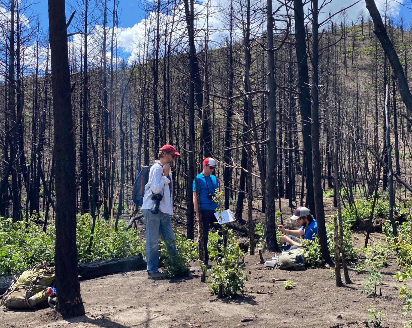
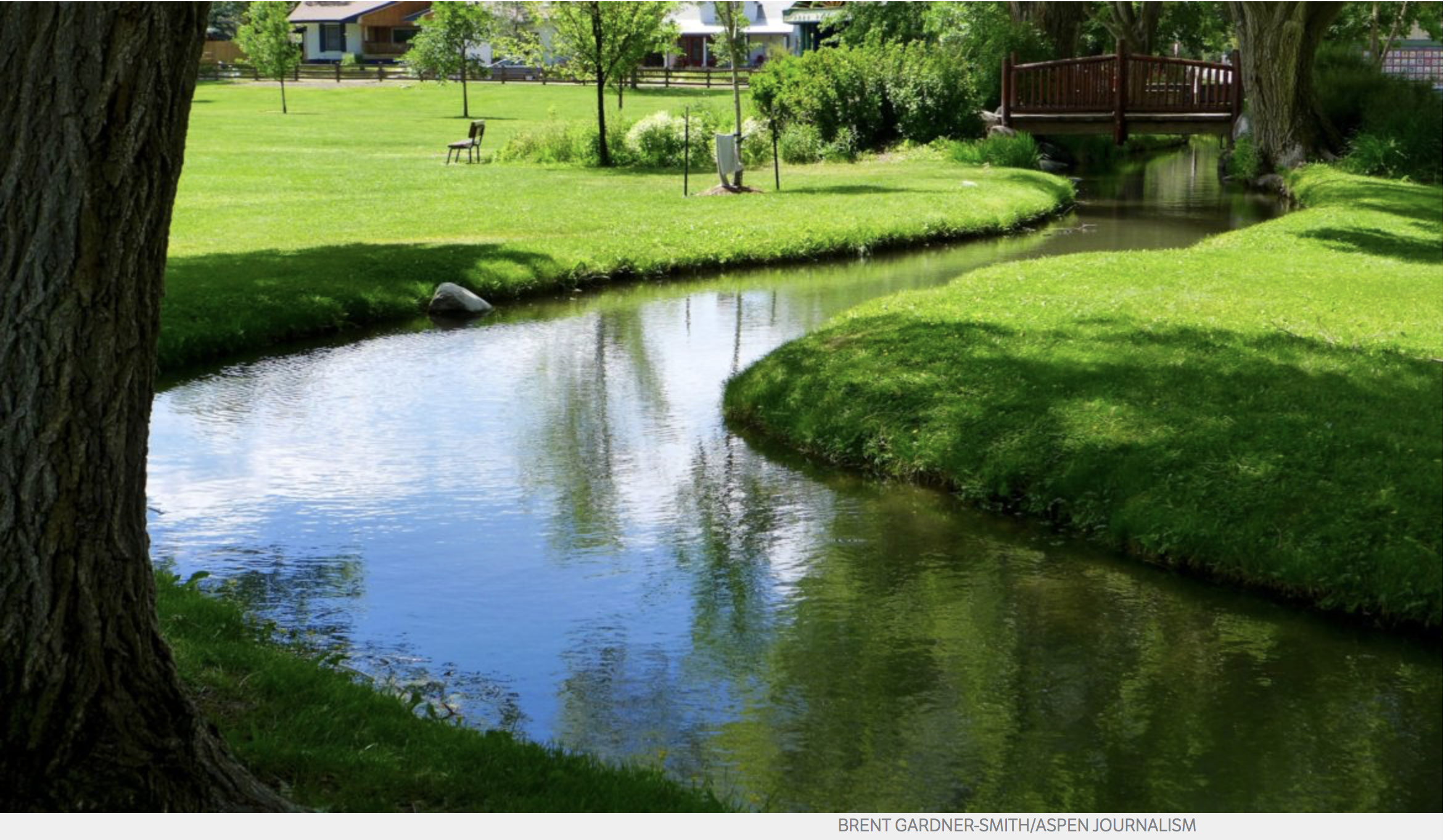


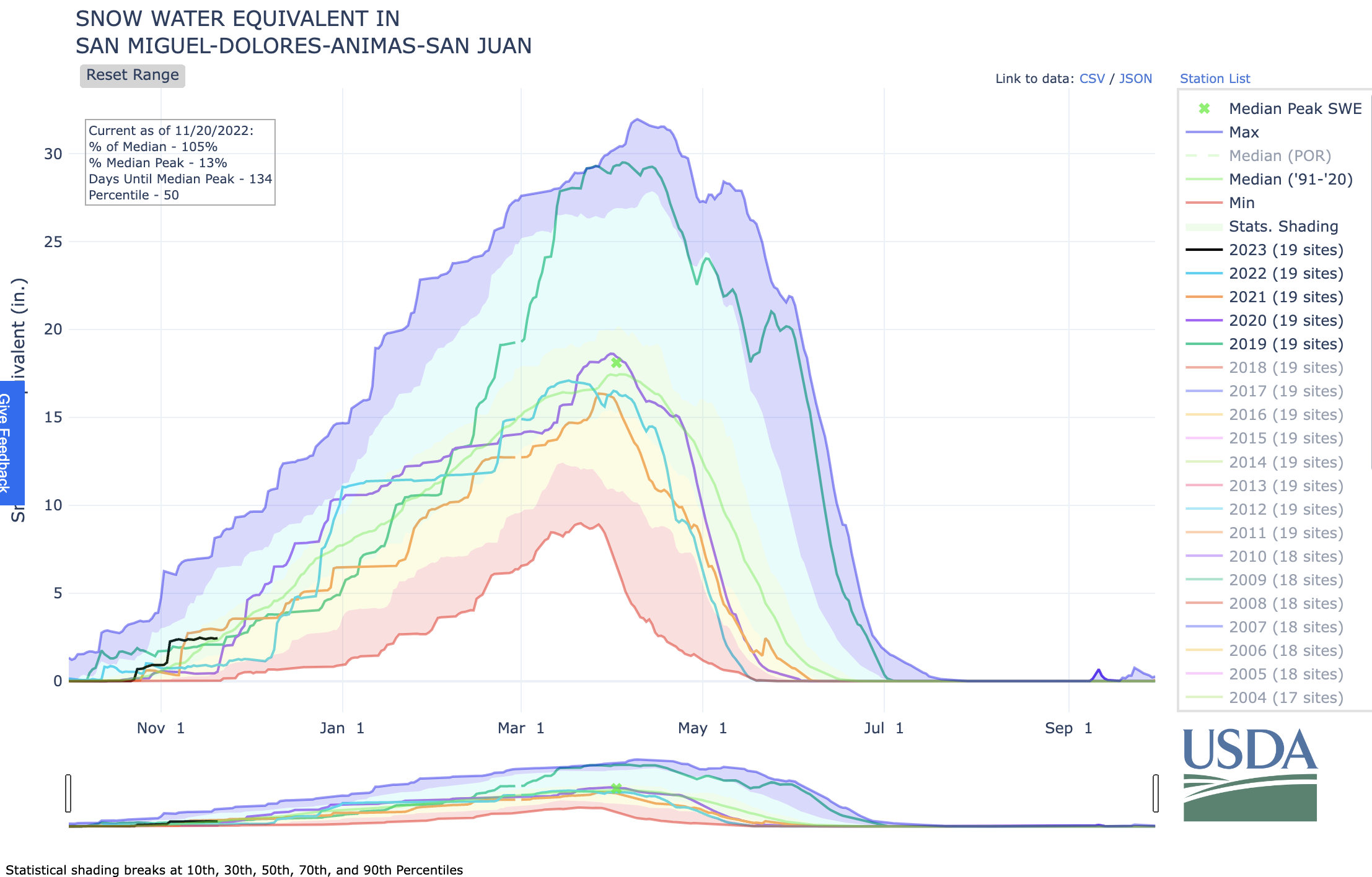
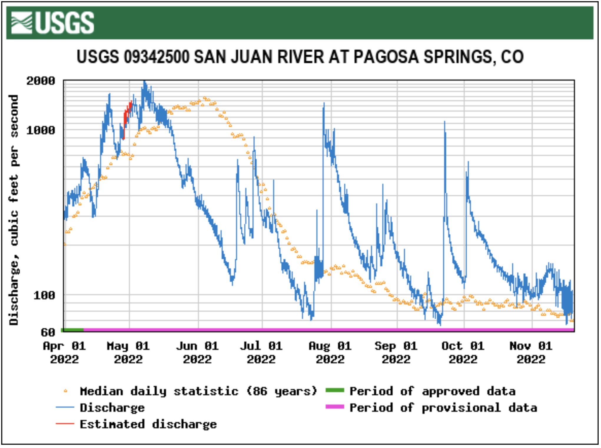

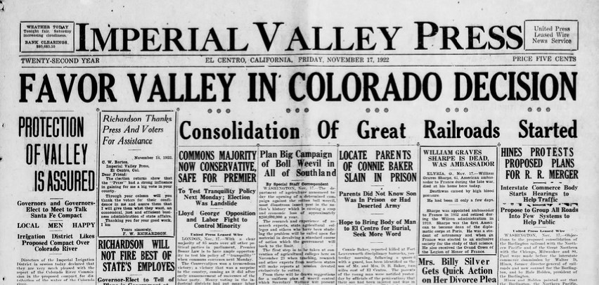


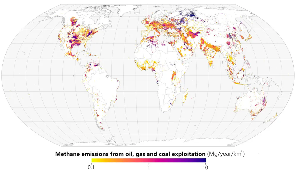


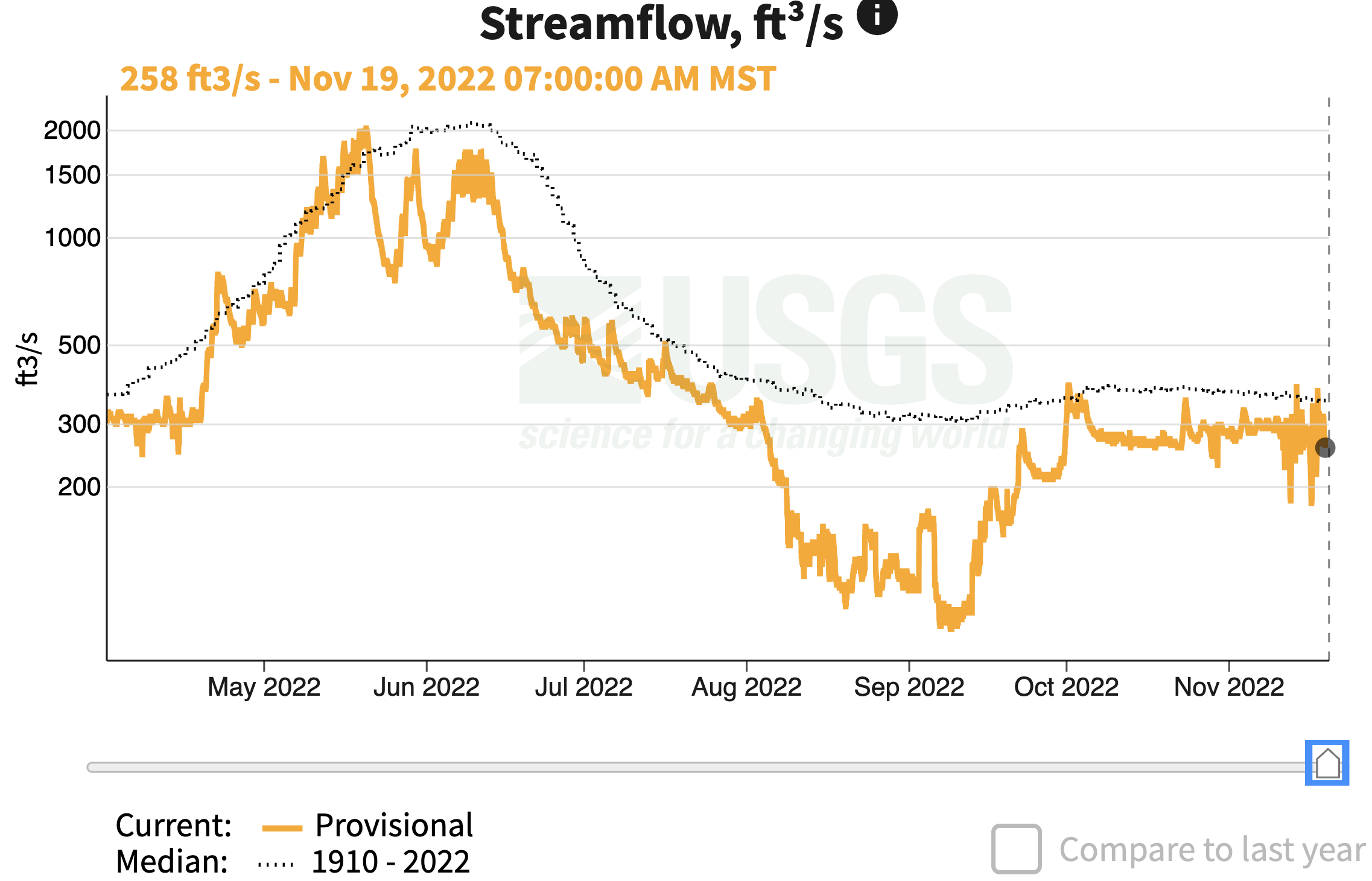

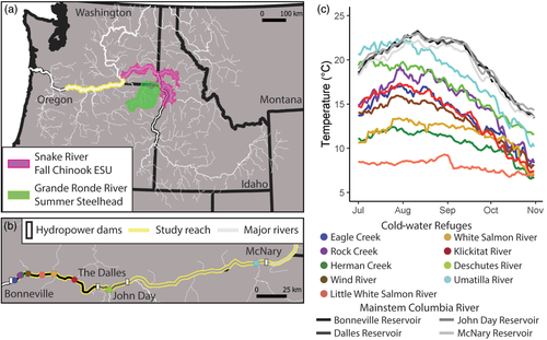
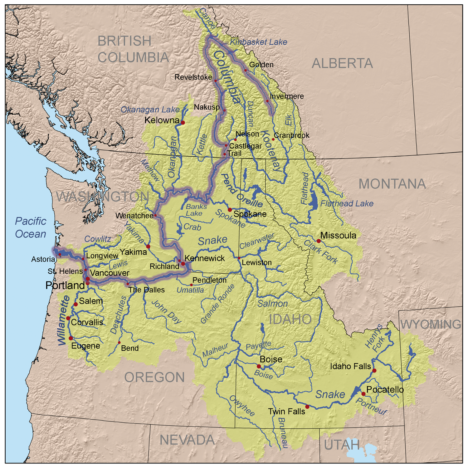

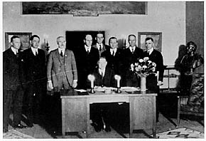
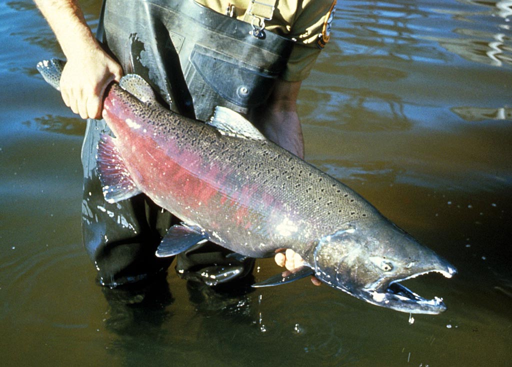
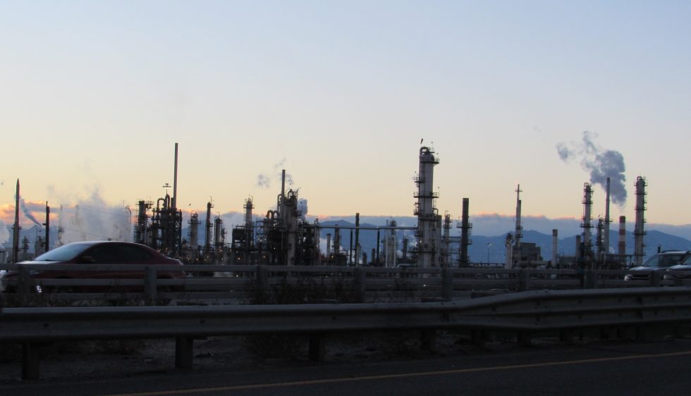


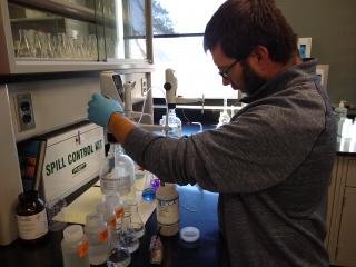


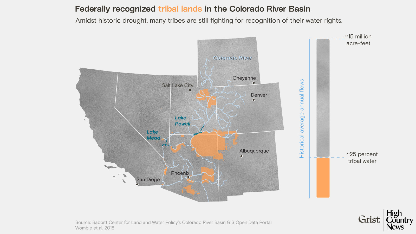
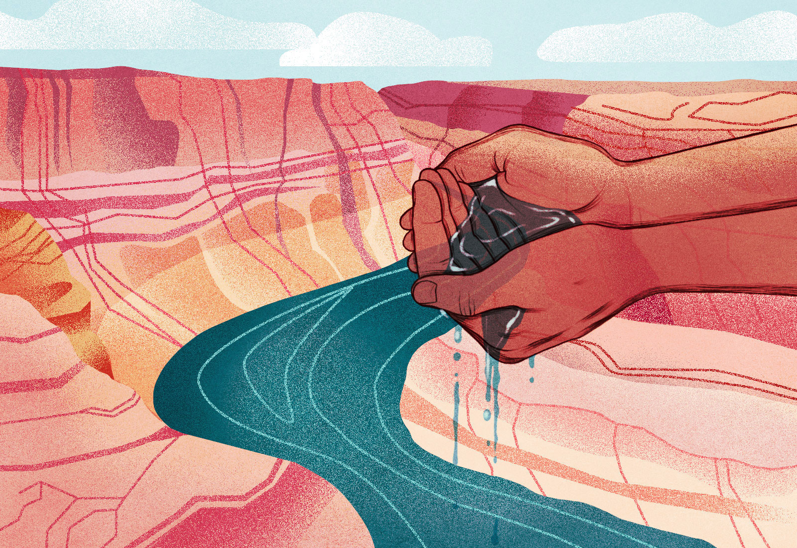
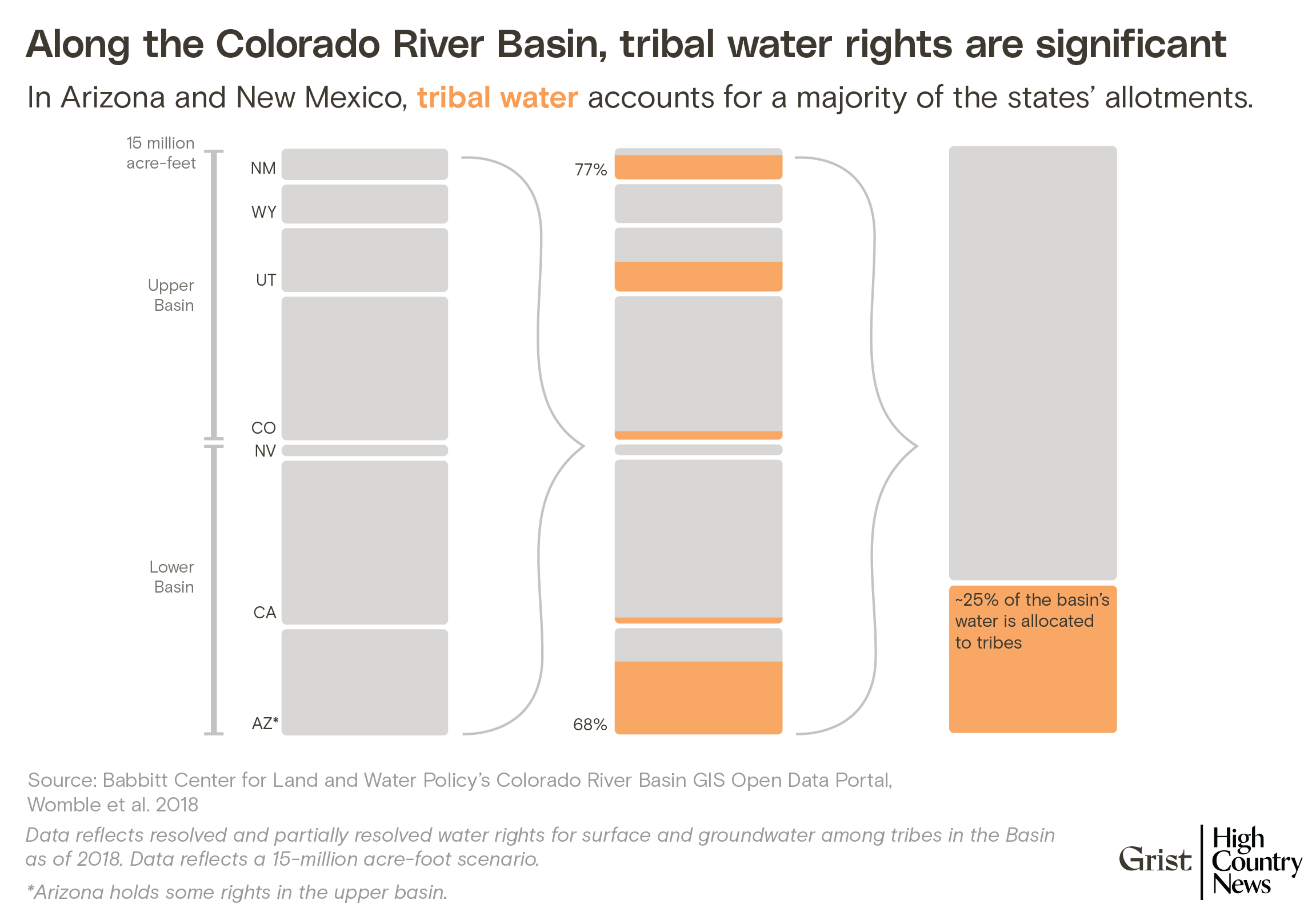
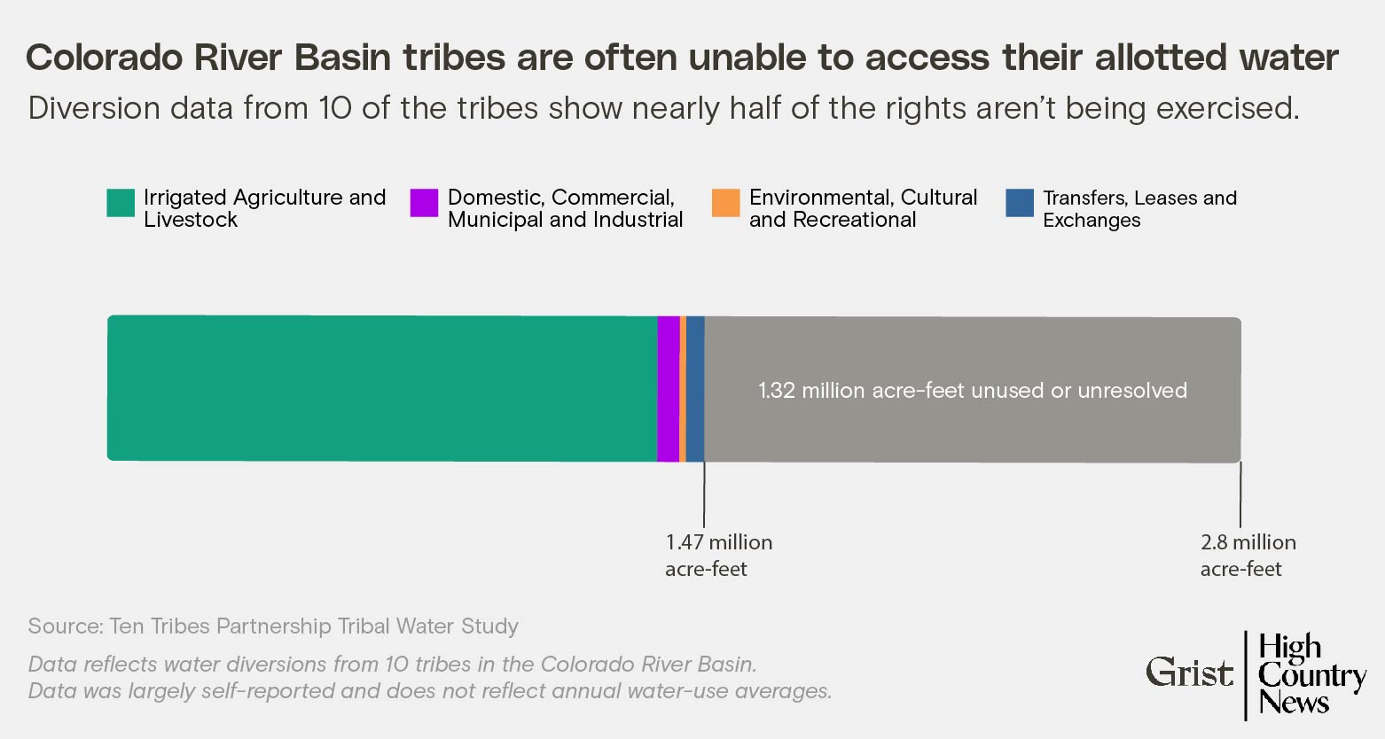
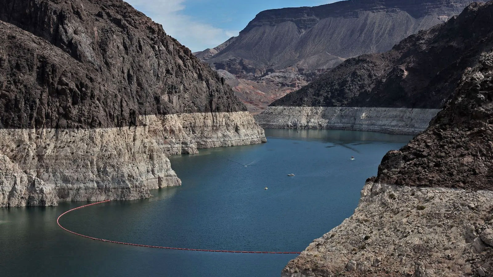
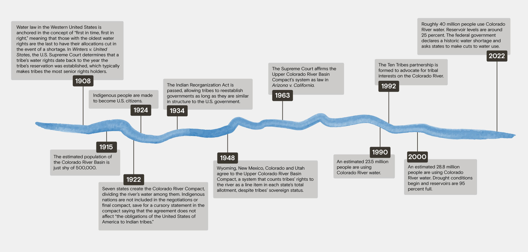
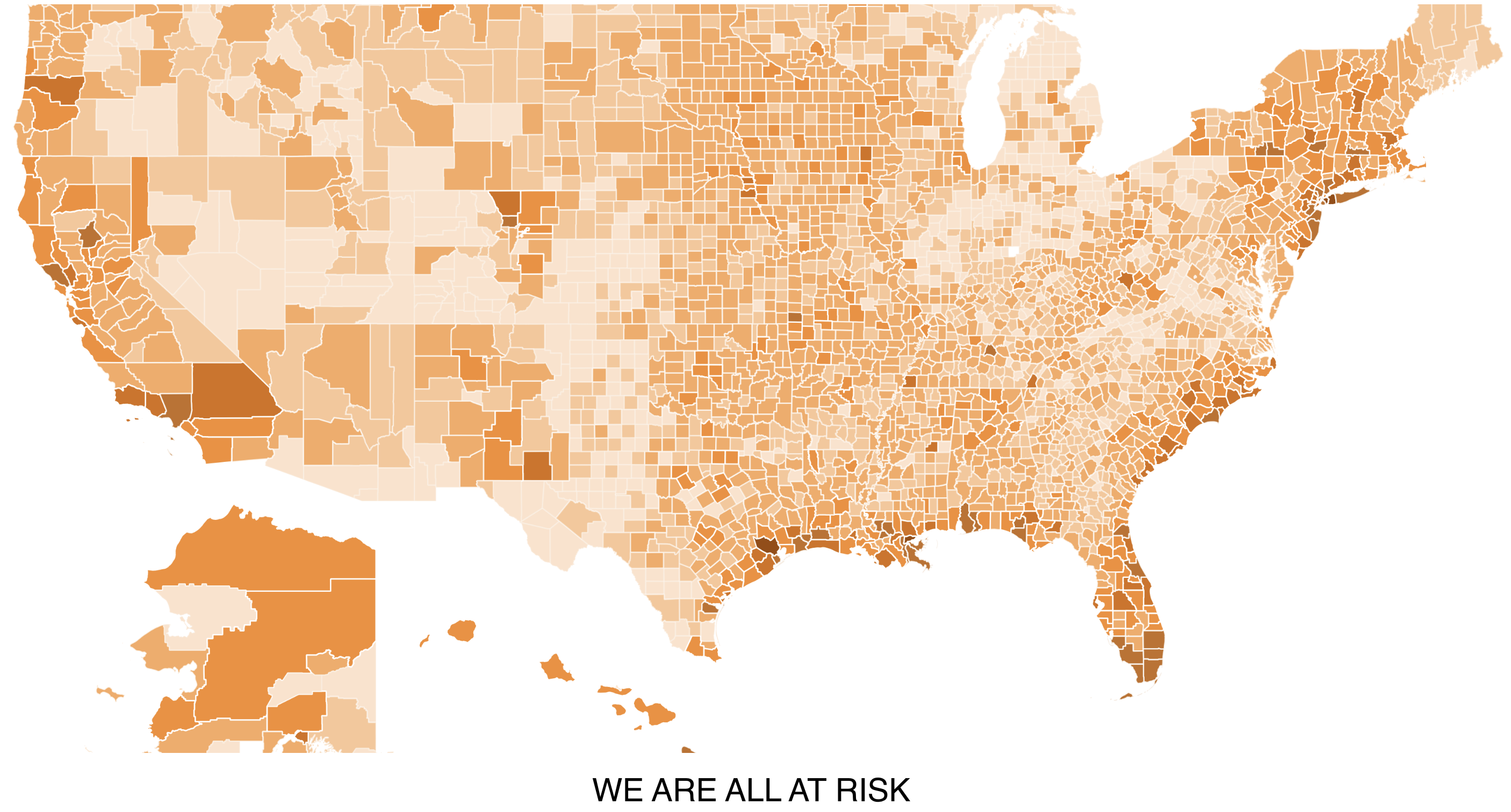
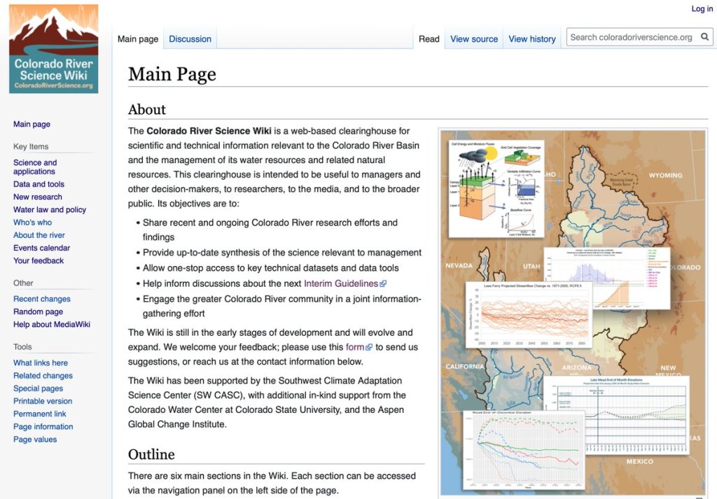


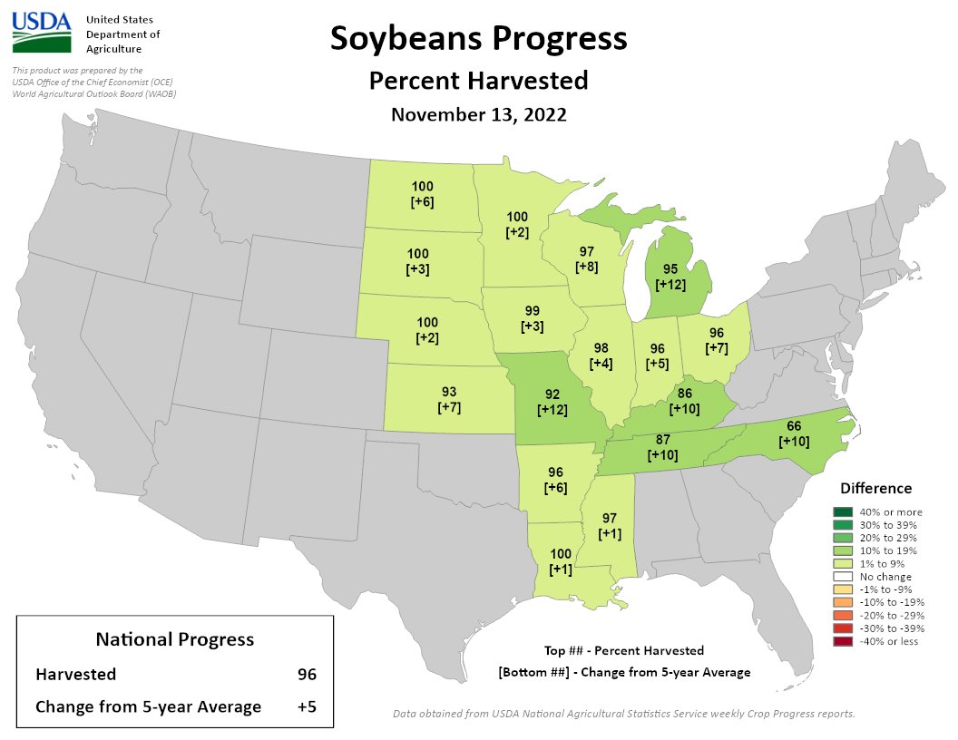
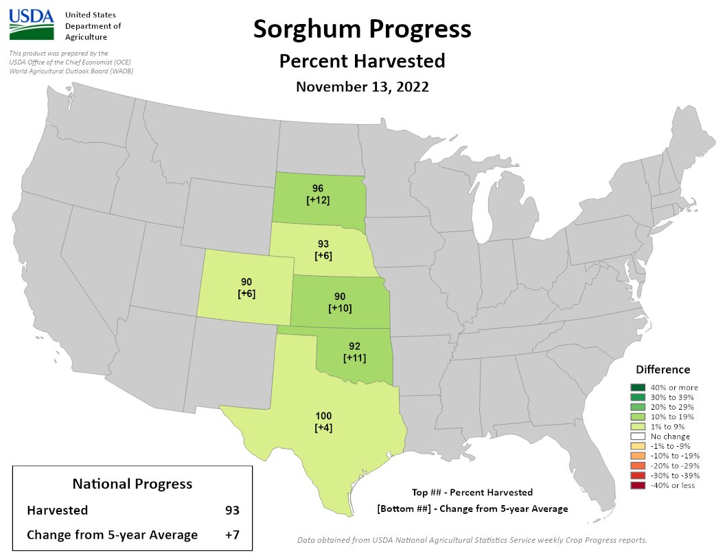
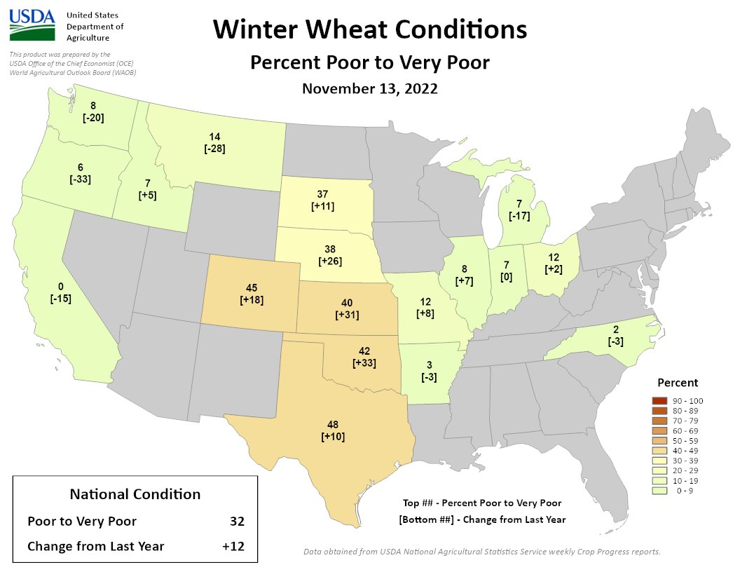
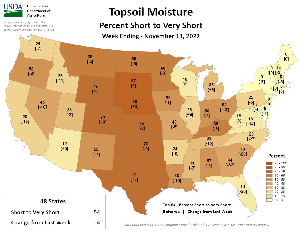
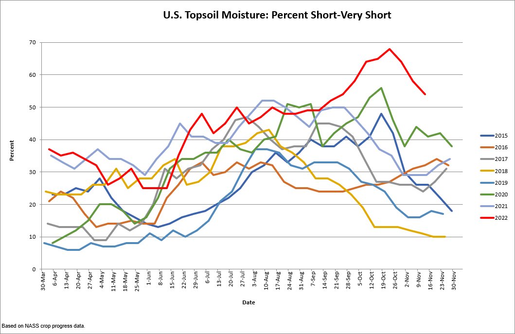
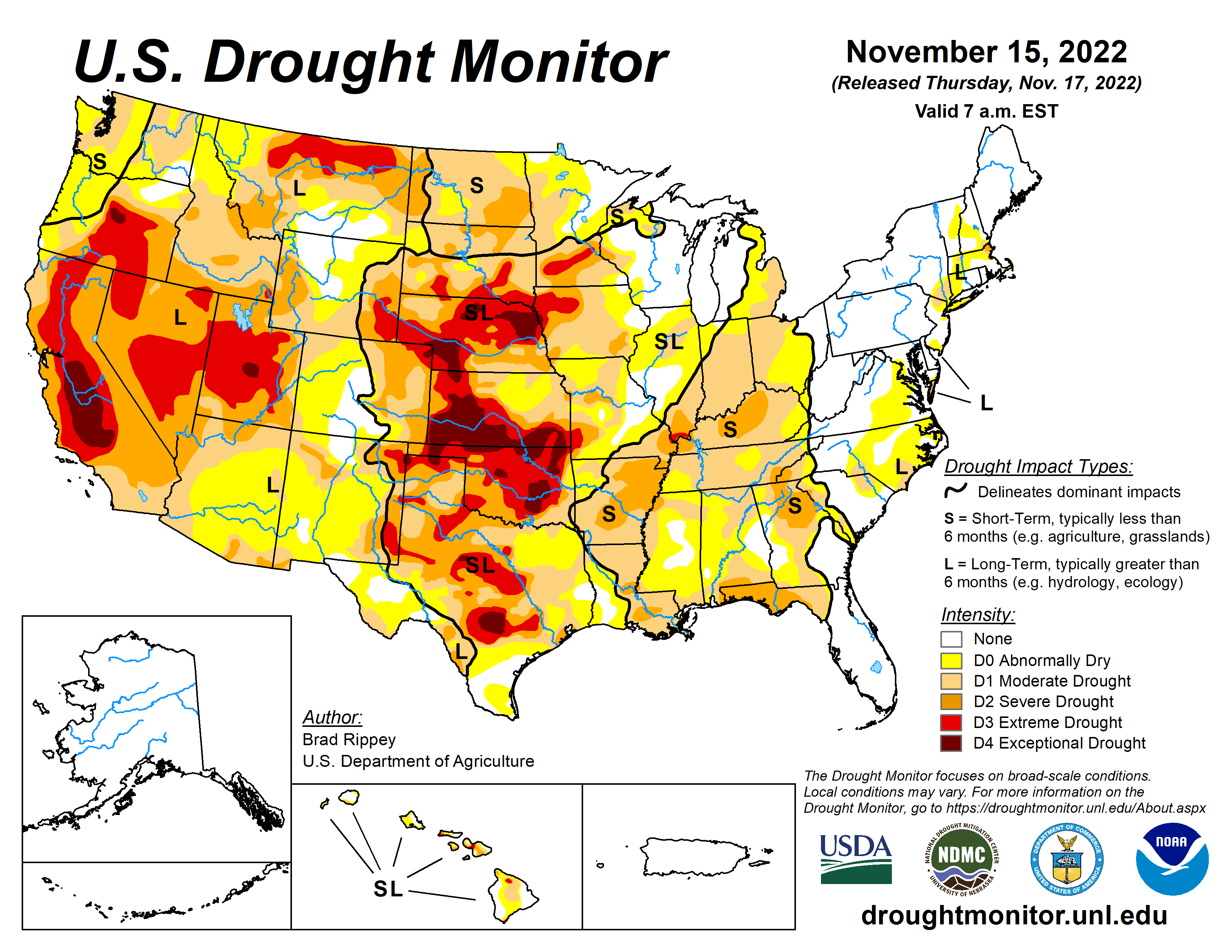
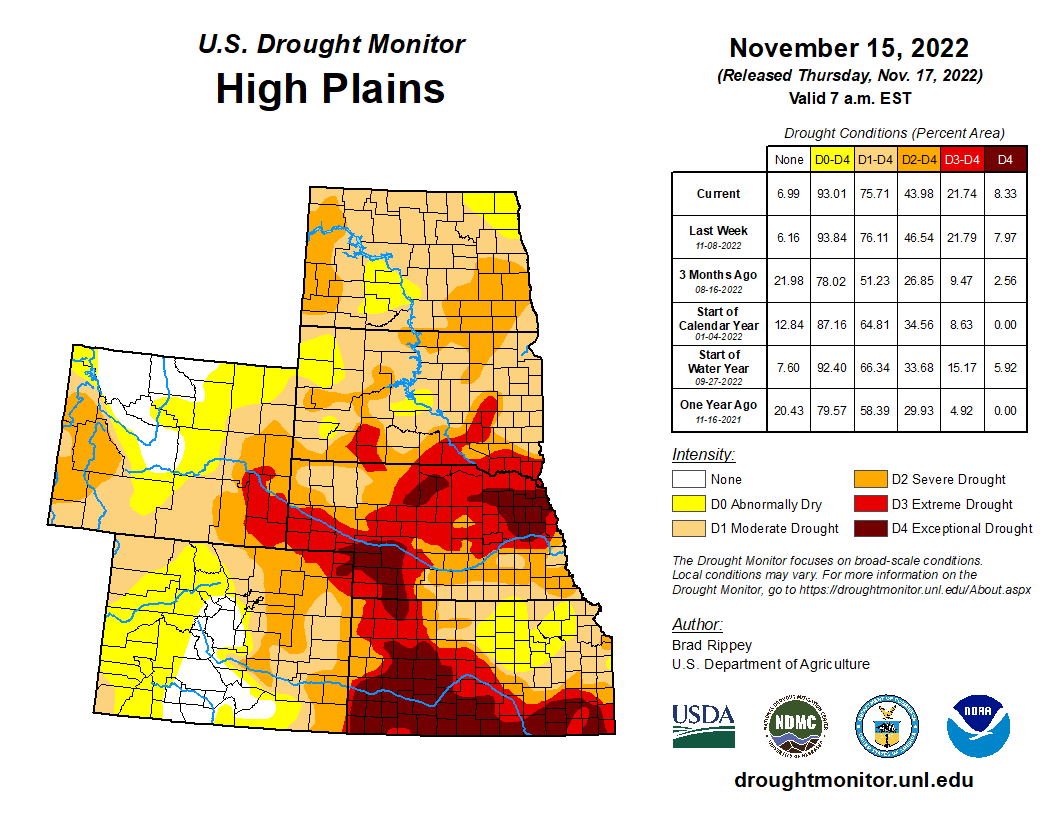
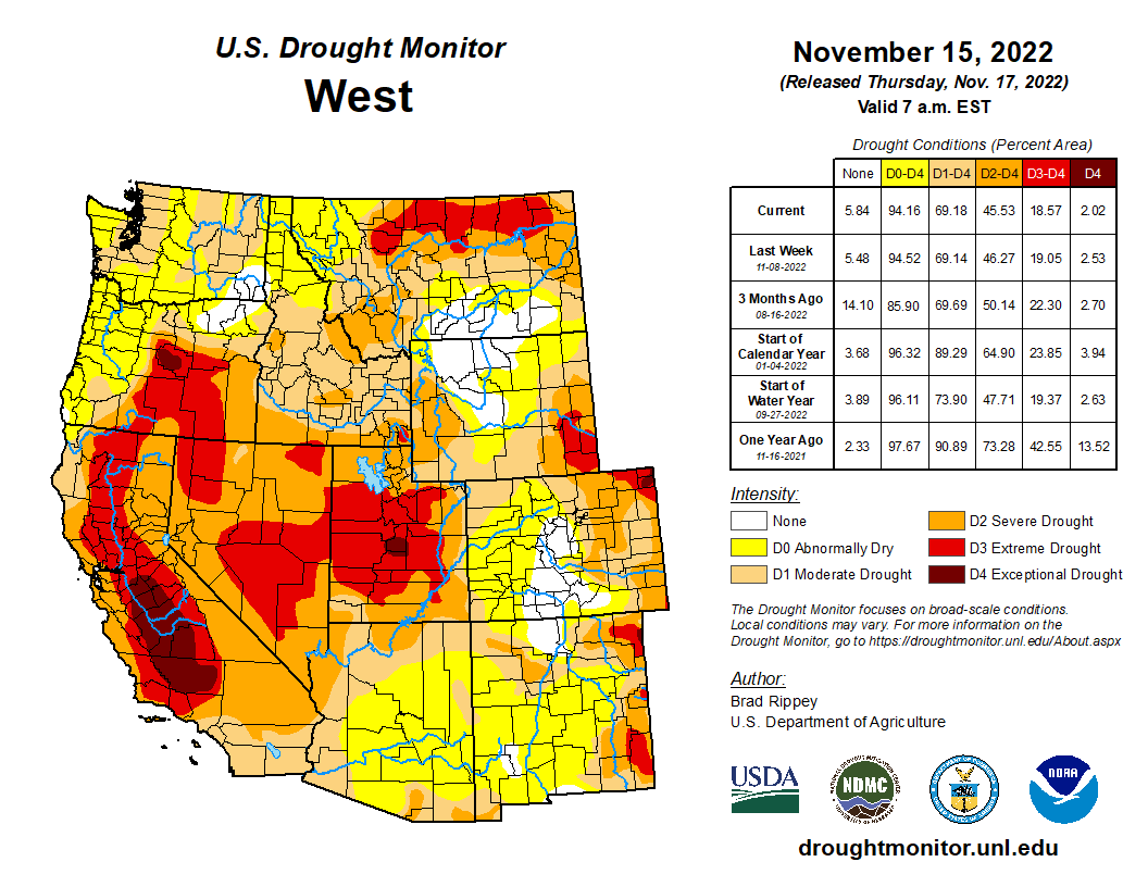
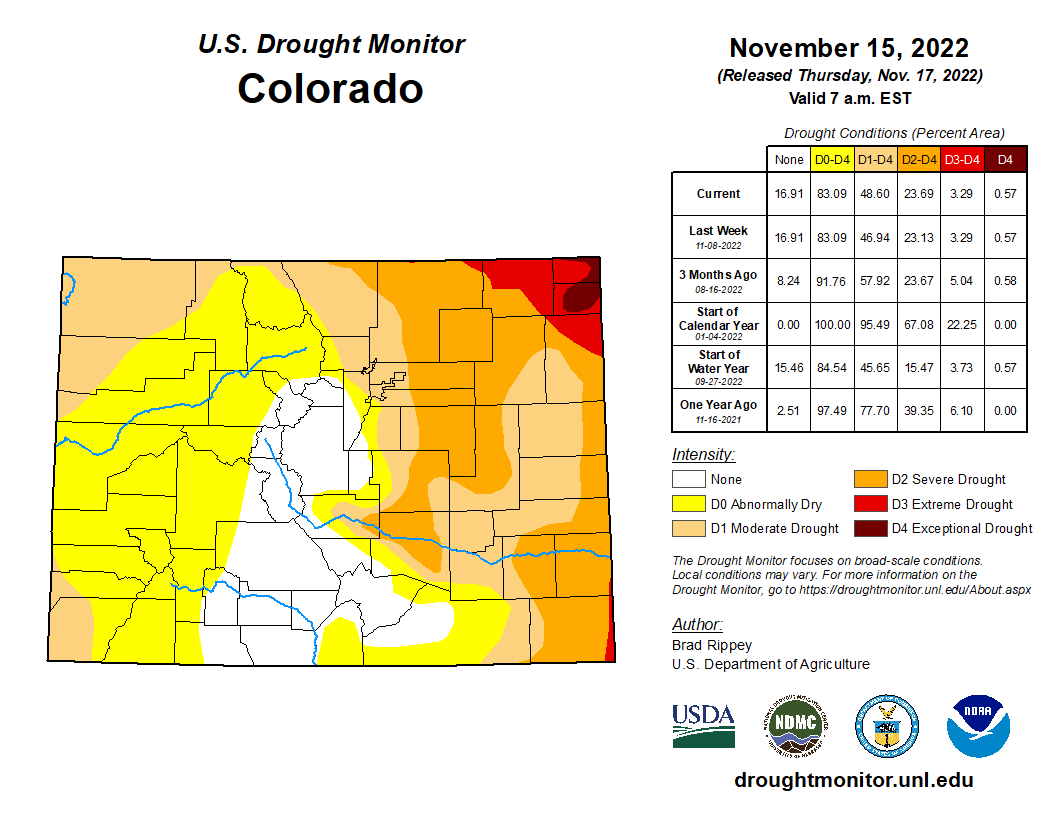
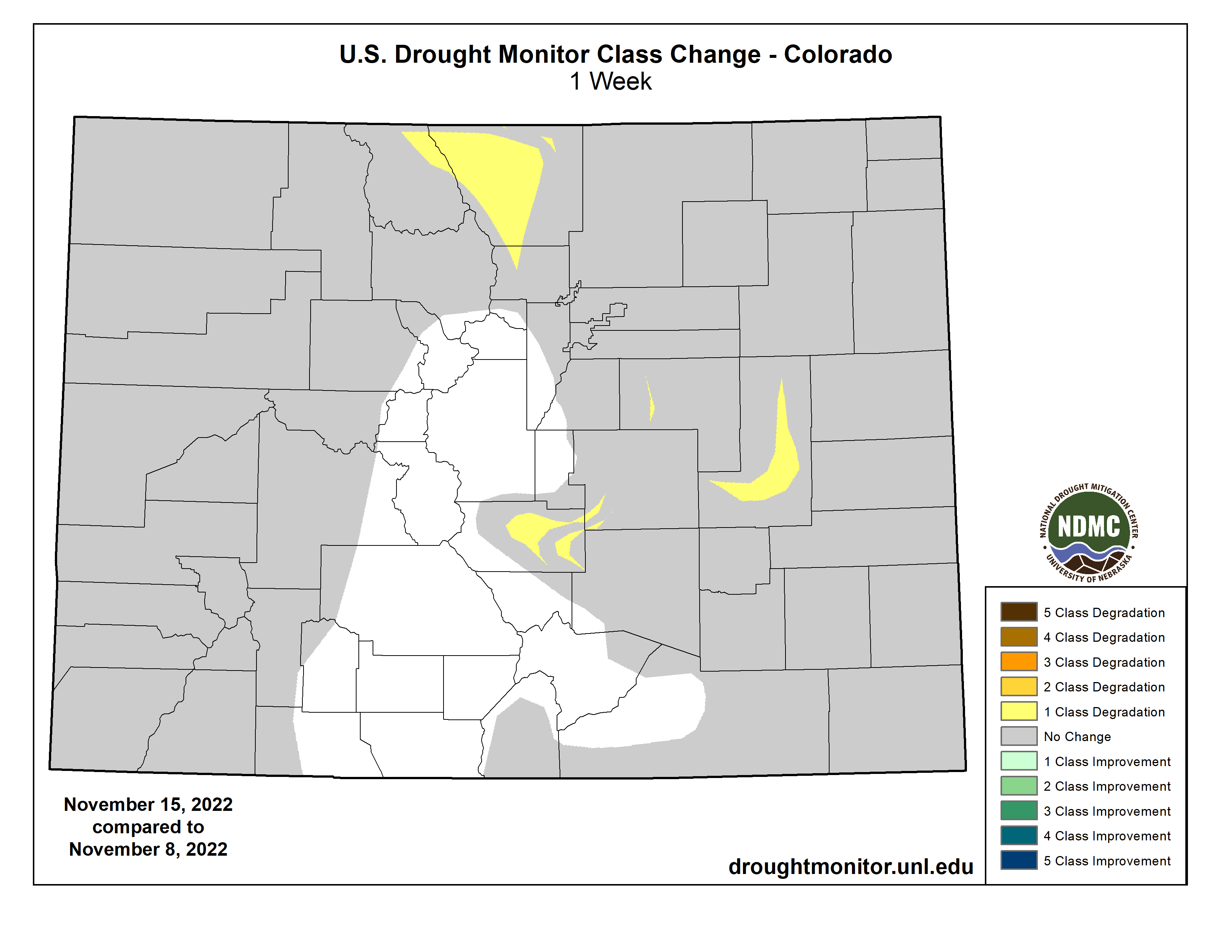
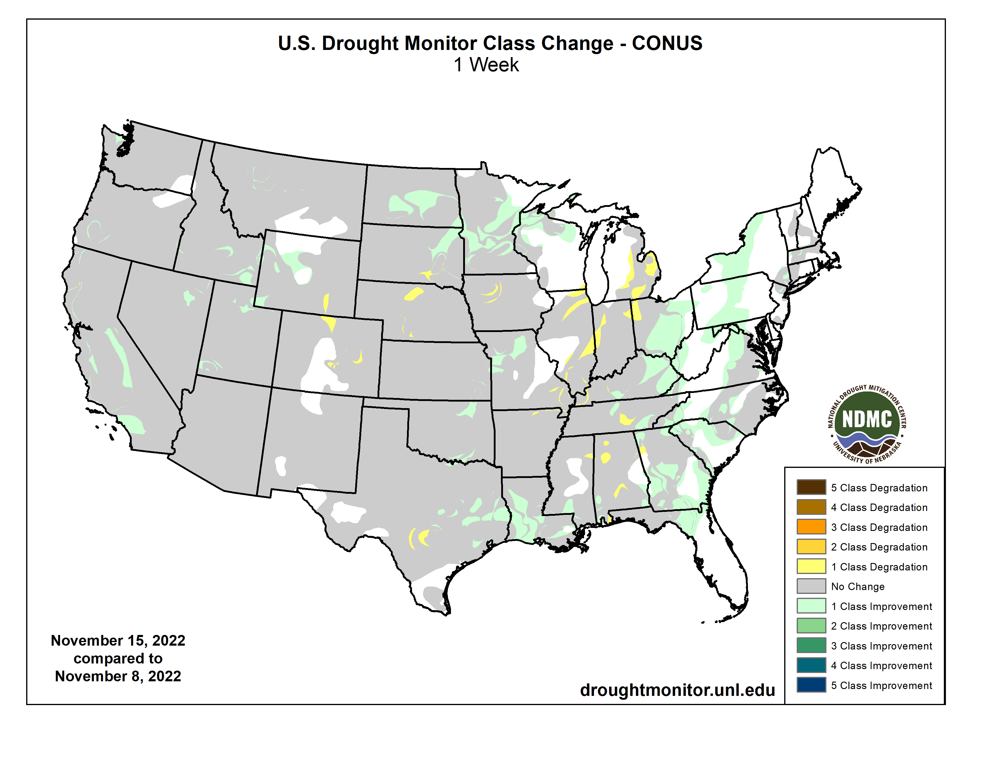
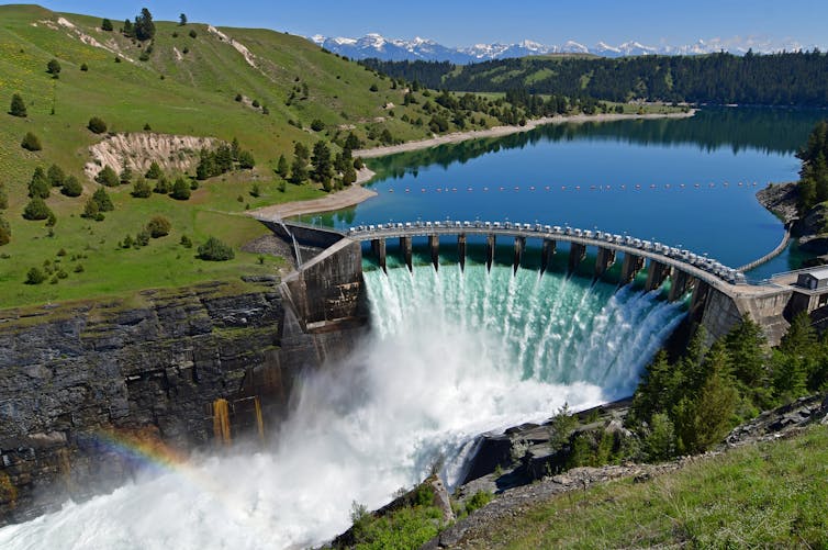

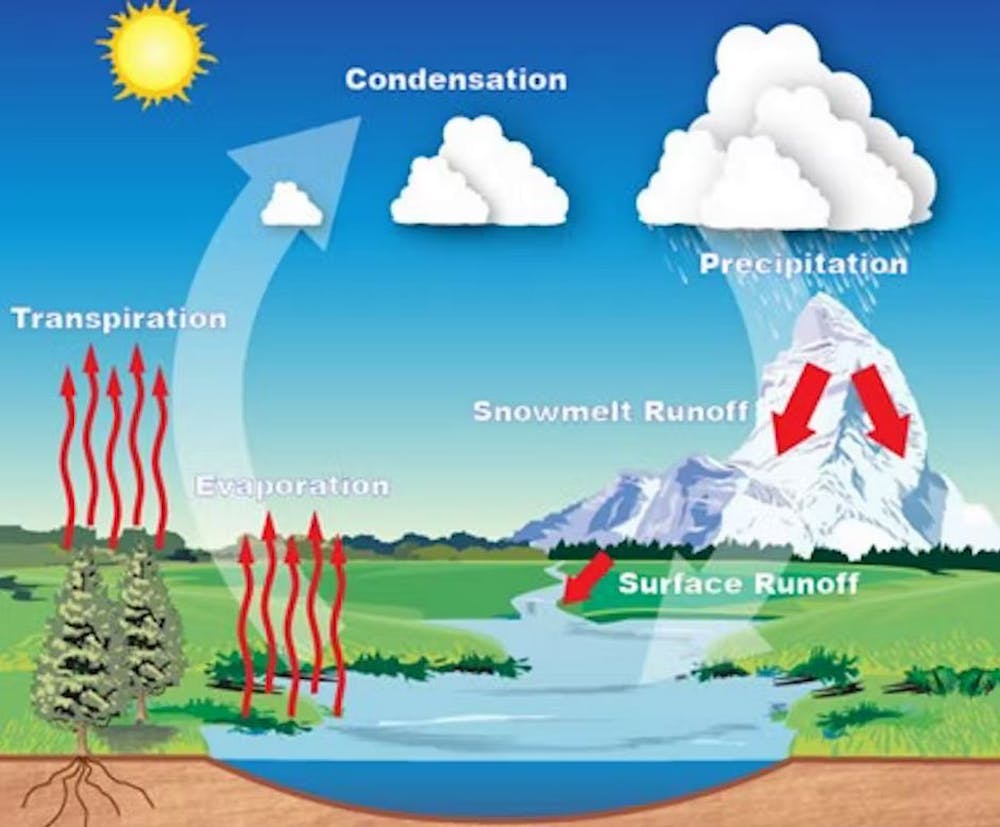
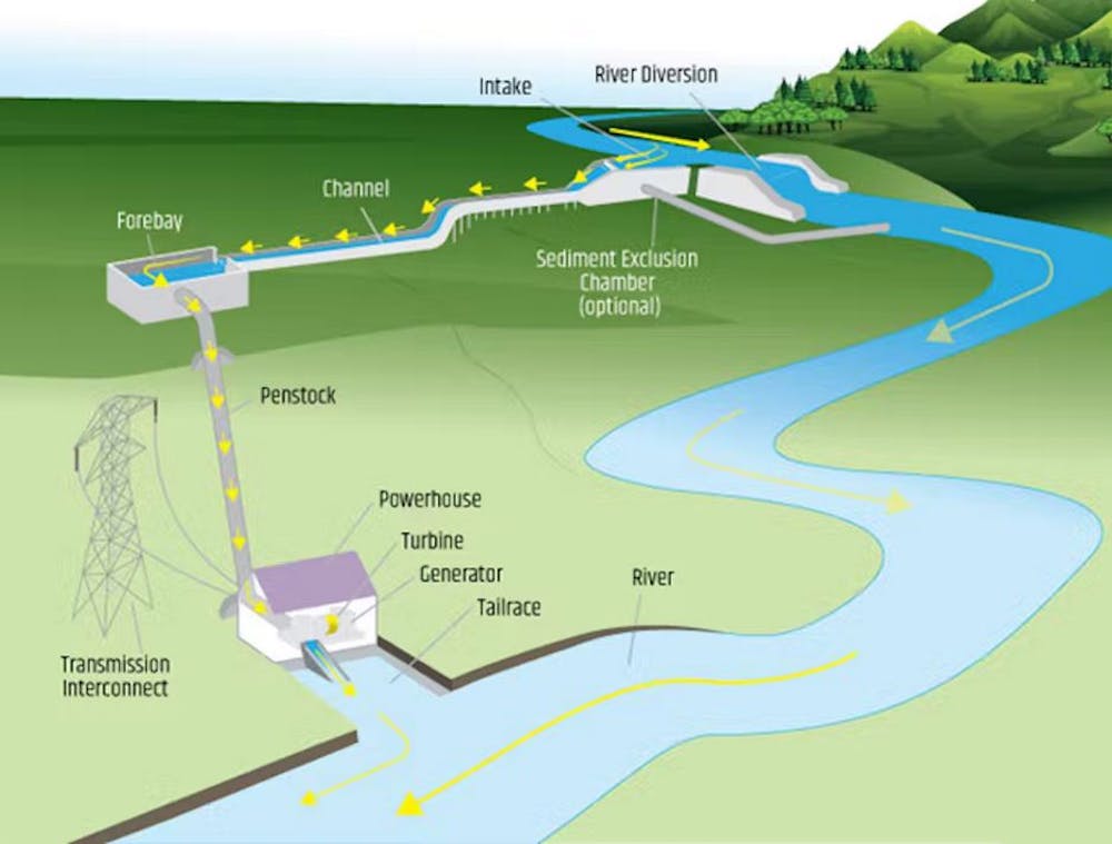
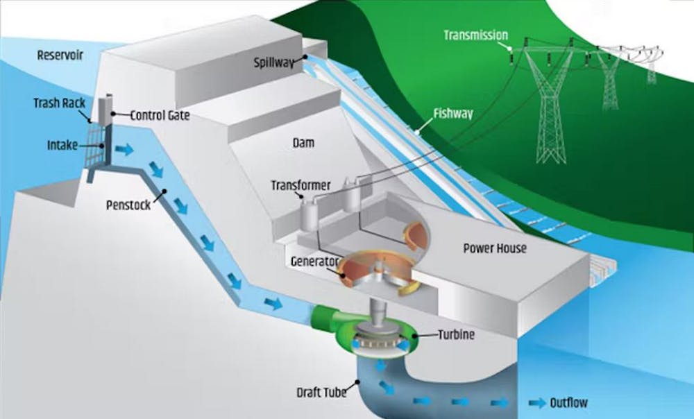


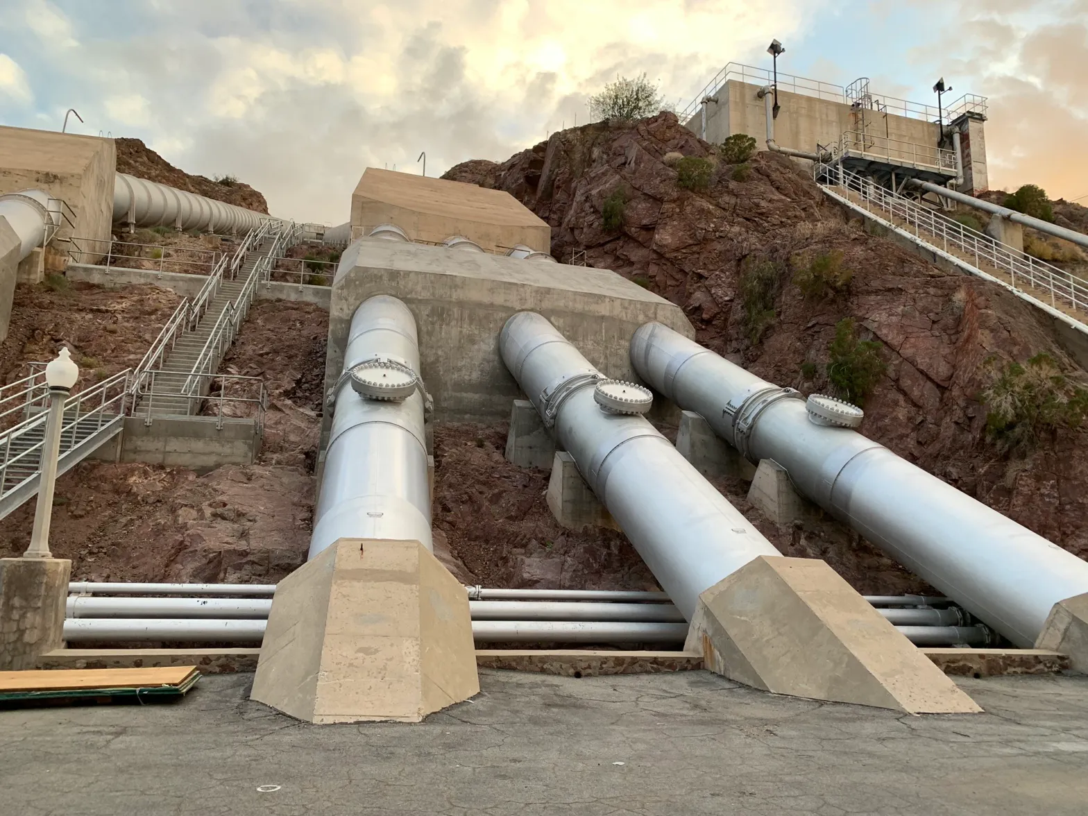


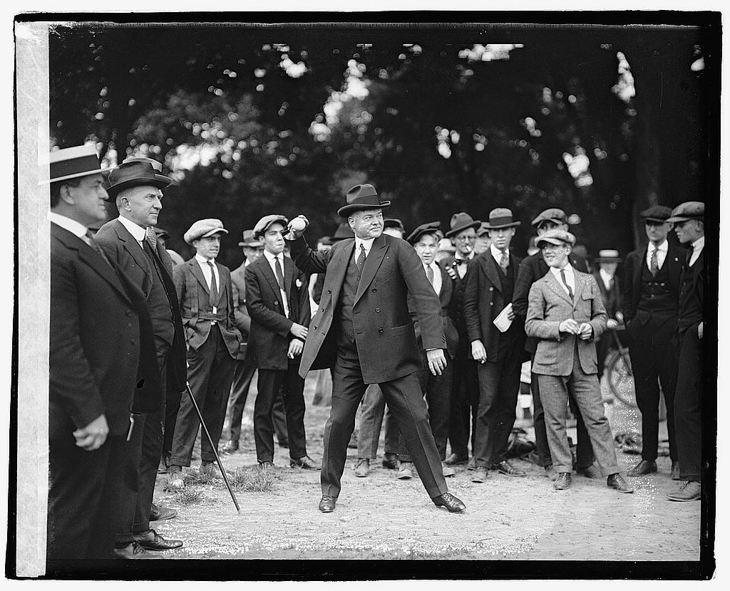


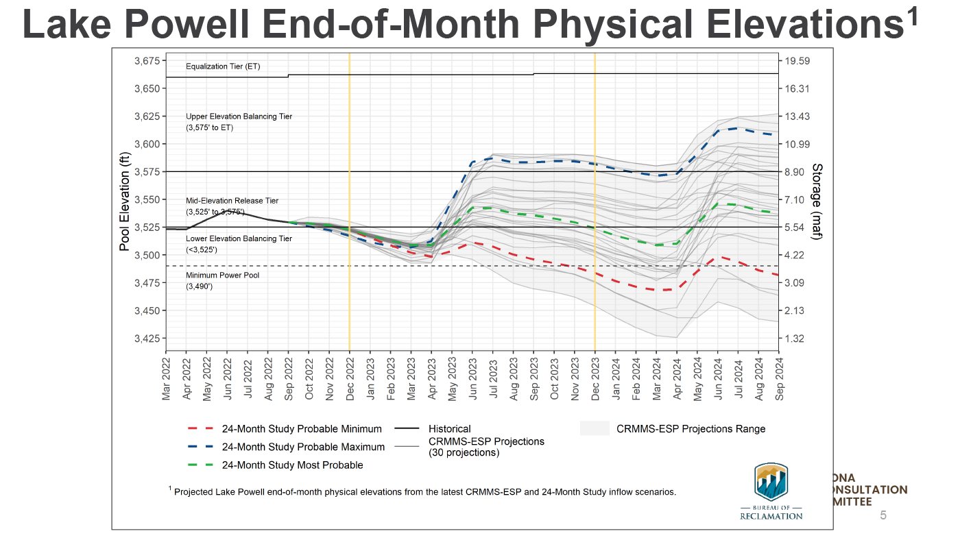
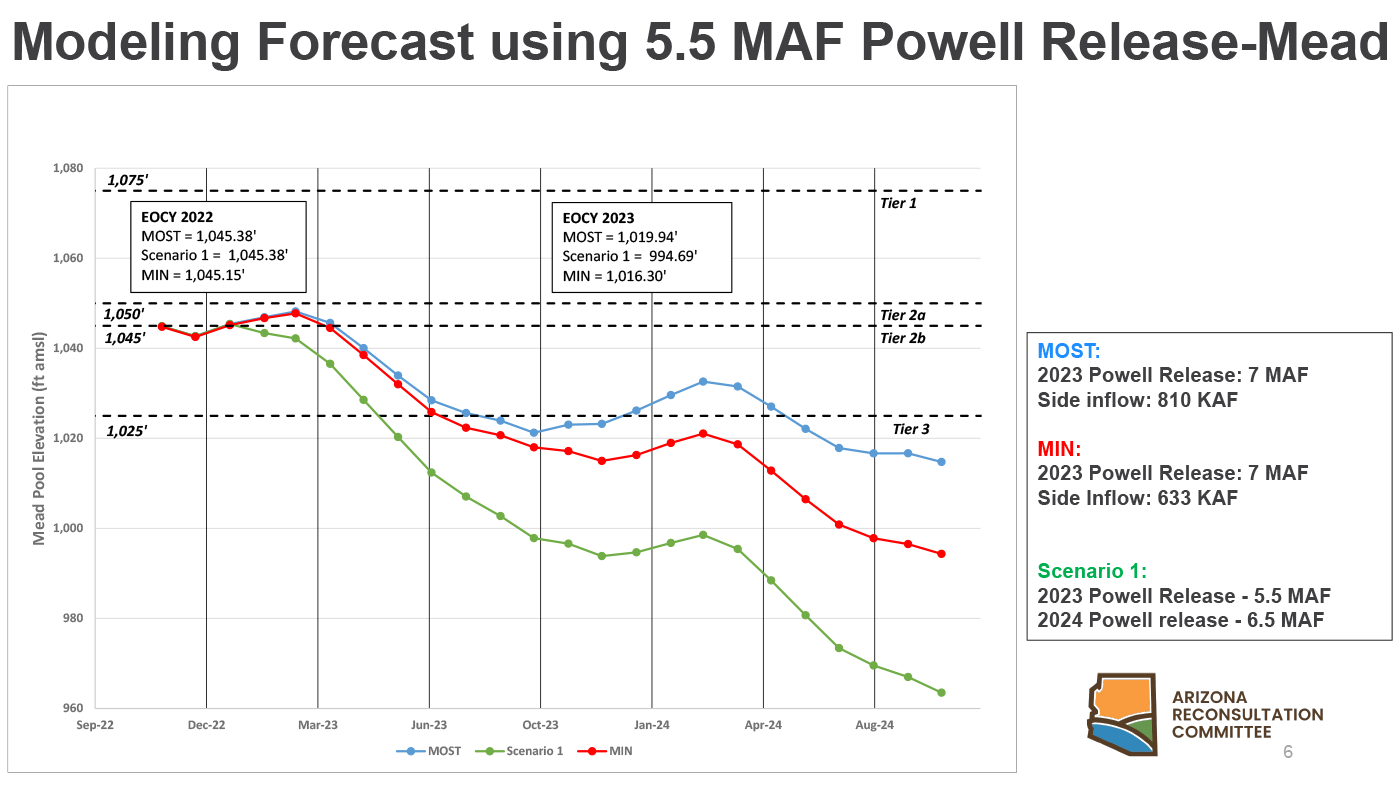

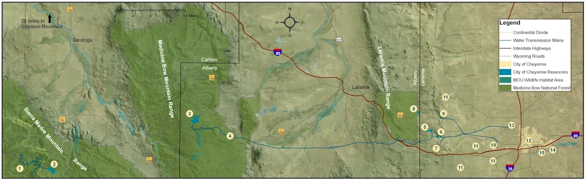
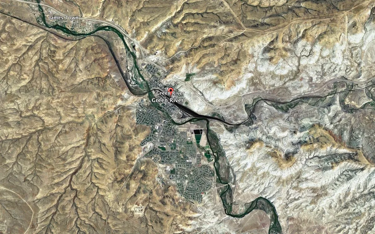
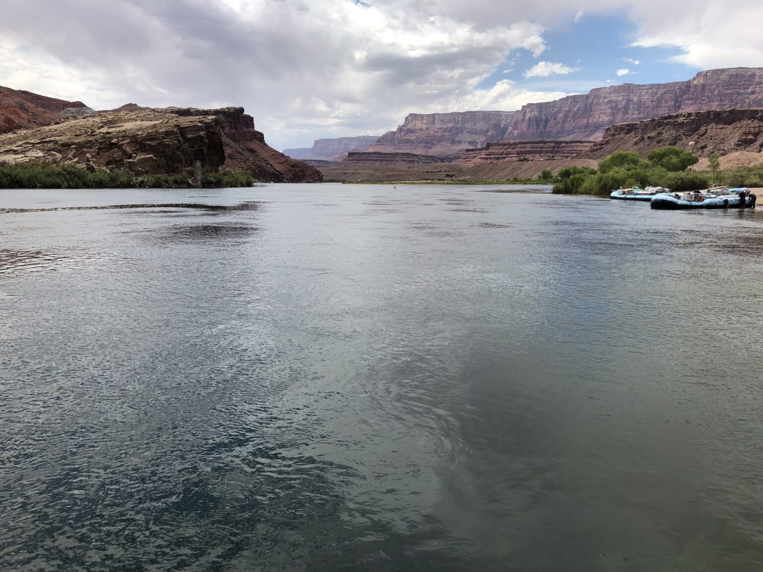


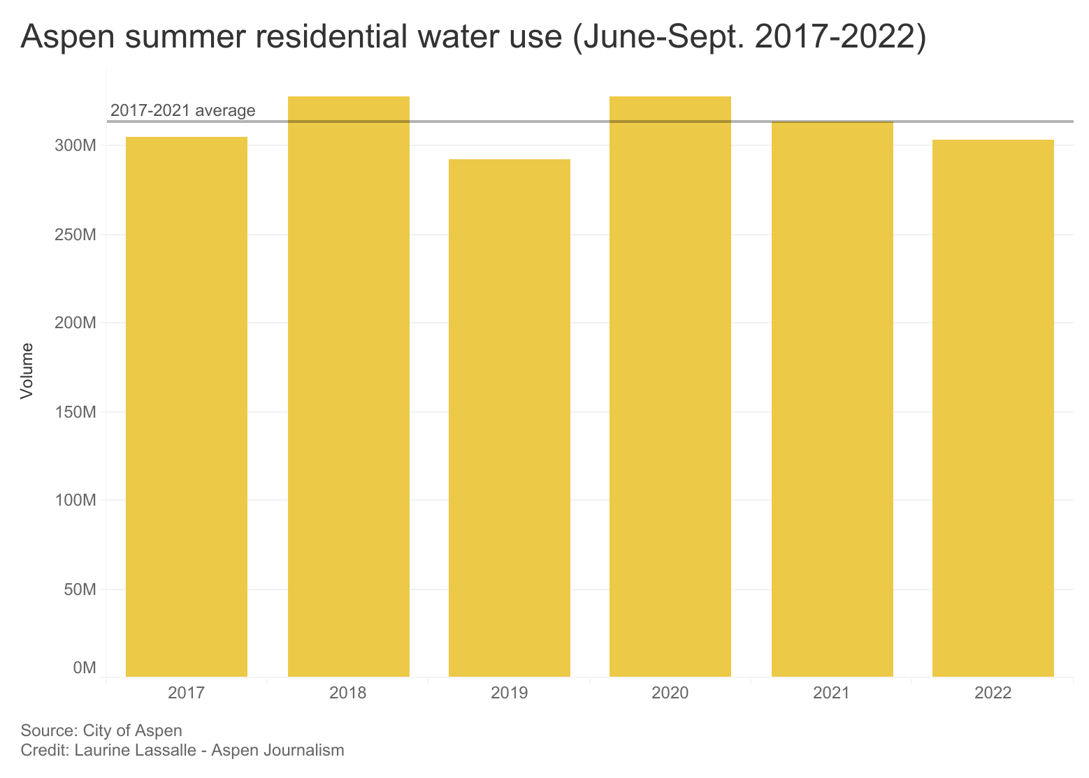

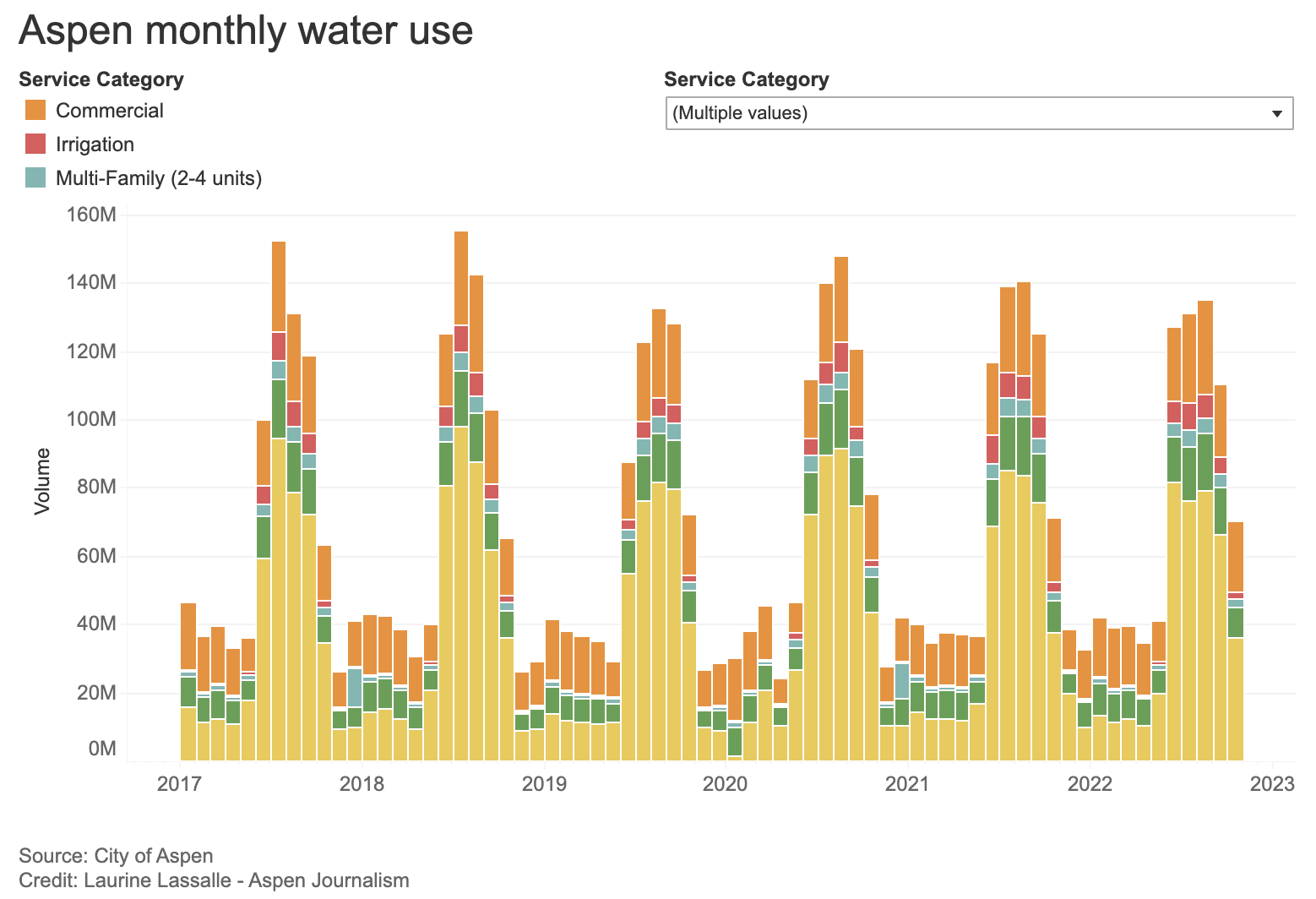


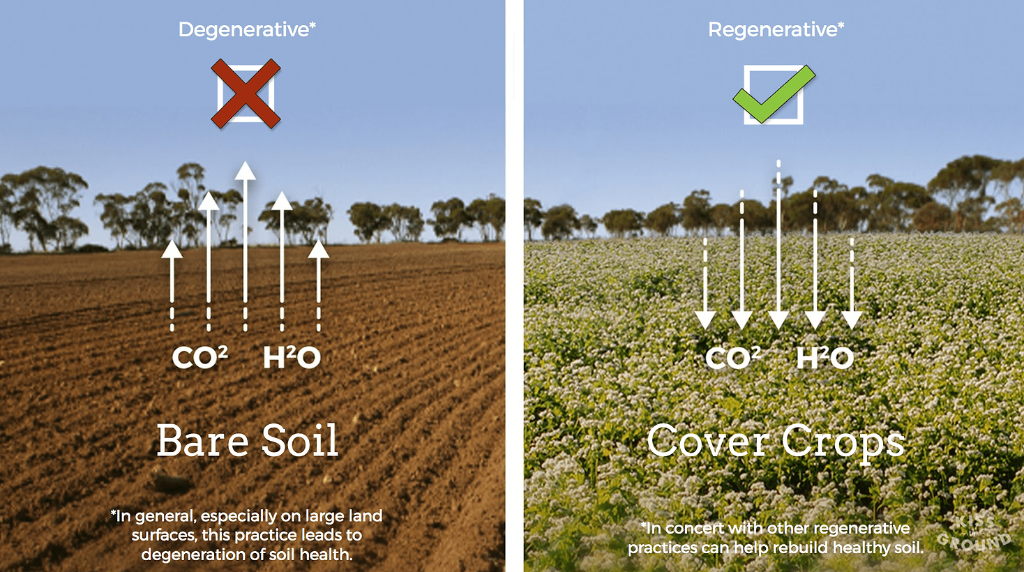

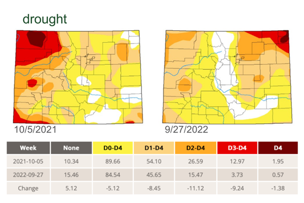
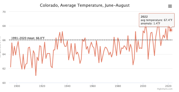
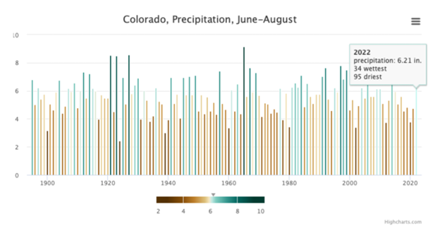
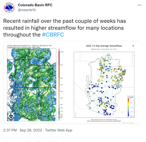
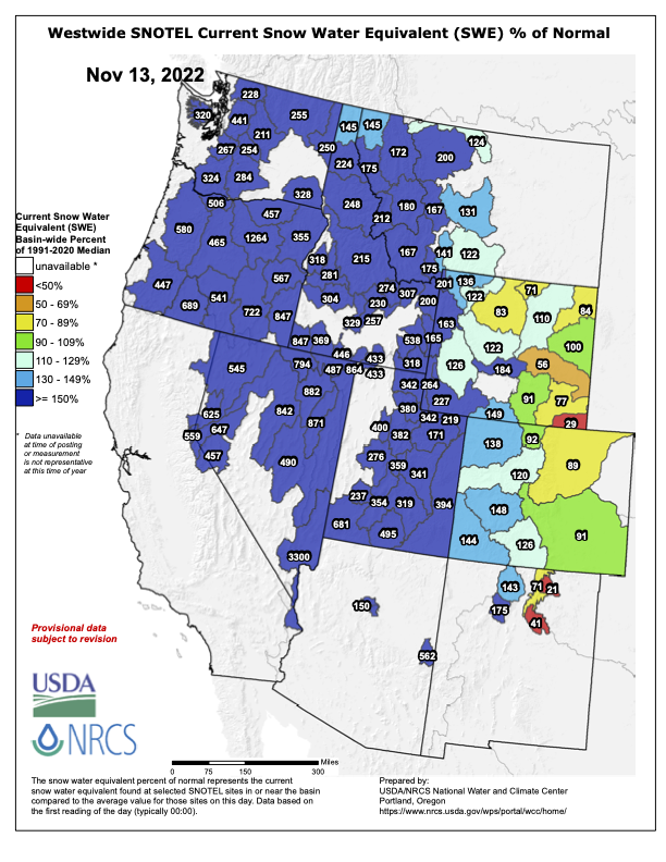


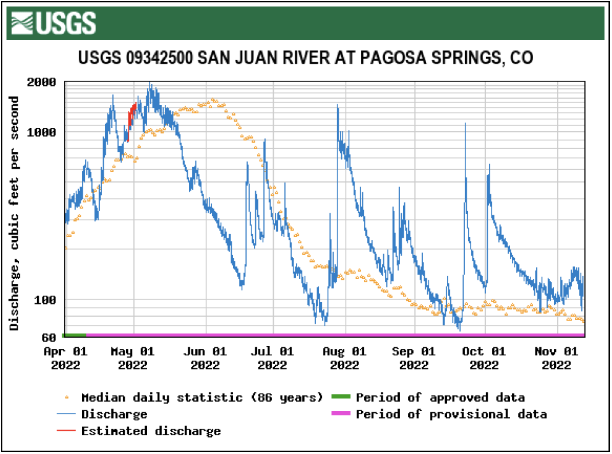
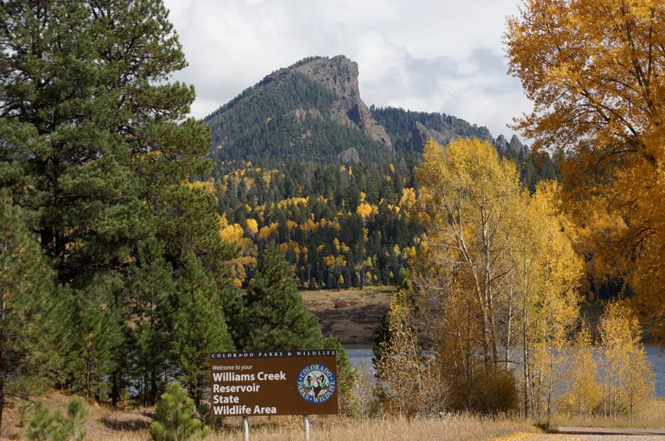
