Sambrito Wetlands restoration project beginning in January at Navajo State Park — #Colorado Parks & Wildlife #SanJuanRiver

The Sambrito Wetlands at Navajo State Park will undergo a project to restore 34 acres of the wetlands and streamside habitat beginning the first week of January. John Livingston/CPW

Click the link to read the article on the Colorado Parks & Wildlife website (John Livingston):

A project to restore an additional 34 acres of wetland and streamside habitat is set to begin its final phase in January at the Sambrito Wetlands Complex at Navajo State Park. The area will be closed to the public during construction and will be well marked with closure signs.

This project, coordinated by the Bureau of Reclamation, Colorado Parks and Wildlife and Ducks Unlimited, will bring to life the vision of a myriad of partners who have participated in various planning efforts for the project during the last decade.

โ€œWe are happy to see this project come to fruition after multiple years of work and planning,โ€ said CPW Deputy Southwest Region Manager Heath Kehm. โ€œThrough the work of key partners and funding through several grants, we are eager to see this area of Navajo State Park restored for the benefit of wildlife, wildlife viewing and waterfowl hunting here in southwest Colorado.โ€

The Sambrito Wetlands are on federal land owned by the Bureau of Reclamation and managed under agreement by CPW. Sambrito is part of a wetland complex in Colorado that was enhanced to benefit wildlife during construction of Navajo Dam on the San Juan River.

Since its construction, the water infrastructure and ditches have fallen into disrepair, resulting in diminished environmental and recreational benefits.

In 2012, CPW commissioned a management plan that identified several areas where infrastructure improvements could be made to restore wetland function and increase recreational opportunities. In 2013, CPW funded an initial phase of work which was completed in 2016.

This current project will continue and complete all work identified in the management plan published in 2013 to restore the Sambrito Wetlands to full functionality.

The Sambrito and adjacent Miller Mesa Wetlands Complex were intensively managed for wildlife between 1964 and 1993 through habitat improvements, food production units and wetland creation and enhancements. However, the complexes were not as actively managed in the intervening years and became dilapidated because of limited resources.

The New Mexico meadow jumping mouse (Zapus hudsonius luteus) is native to the southern Rocky Mountains. It is 7 to 9 inches long including its tail, which is more than half of its length. The mouse is a jumper, making use of its inch-long back feet. It lives among dense, tall, herbaceous (non-woody) plants that are next to flowing streams and eats a variety of plant material, such as grass seeds and flowers. Photo credit: National Park Service

The current project will reinvigorate waterfowl habitat and improve recreational opportunities by renovating and repairing the existing water diversion and conveyance system, which will deliver water from West Sambrito Creek (Vallejo Arroyo) to five wetland impoundments. The project will also restore hydrologic functions to a section of West Sambrito Creek and potentially benefit the endangered New Mexico meadow jumping mouse.

Strategies to avoid and minimize impacts to the New Mexico meadow jumping mouse and its habitat guided development of the project, and Bureau Reclamation staff will be onsite to monitor construction activities occurring in critical habitat.

Ducks Unlimited designed and engineered the wetland improvements and will lead as the project manager. Geringer Construction, a contractor from the San Luis Valley experienced in wetland restoration, will work on the project from early winter through spring 2023.

โ€œWe are very excited to move forward with this project,โ€ said John Denton, Colorado Manager of Conservation Programs for Ducks Unlimited, Inc. โ€œThe habitat improvement work in this unique and important wetland complex will highlight this great conservation partnership and will pay dividends for wildlife and the public for years to come.โ€

CPW will provide any ongoing management and maintenance for the wetlands.

Funding for this project has come through the Colorado Water Conservation Board Water Supply Reserve Fund grant, the North American Wetlands Conservation Act grant and the CPW Colorado Wetlands and Wildlife Program grant.

The Southwest Wetlands Focus Area Committee has also been a champion for the project through its continued leadership and support.

CPWโ€™s โ€‹โ€‹โ€‹โ€‹โ€‹โ€‹โ€‹โ€‹โ€‹โ€‹โ€‹โ€‹โ€‹โ€‹โ€‹โ€‹โ€‹โ€‹โ€‹โ€‹โ€‹โ€‹โ€‹โ€‹โ€‹โ€‹โ€‹โ€‹โ€‹โ€‹โ€‹โ€‹โ€‹Wetlands for Wildlife Program is a voluntary, collaborative and incentive-based program to restore, enhance and create wetlands and riparian areas in Colorado. Funds are allocated annually to the program, and projects are recommended for funding by a CPW committee with final approval by the Director.

For more about the CPW wetlands project funding, go to: https://cpw.state.co.us/aboutus/Pages/WetlandsProjectFunding.aspx

Navajo State Park is a major recreational facility in southwest Colorado, drawing more than 300,000 visitors every year. The 2,100-acre park offers boating, fishing, trails, wildlife viewing, 138 camp sites and three cabins.

The next coordination meeting for the operation of the Navajo Unit is scheduled forย Tuesday, January 17thย 2023 — Reclamation #SanJuanRiver #ColoradoRiver #COriver #aridification

Navajo Dam. Photo credit: Reclamation

From email from Reclamation (Susan Novak Behery):

The next coordination meeting for the operation of the Navajo Unit is scheduled for Tuesday, January 17th 2023, at 1:00 pm. This meeting is open to the public and will be held as a hybrid meeting with the following attendance options: 

  • In-person: Farmington Civic Center, 200 West Arrington, in Farmington, New Mexico.  
  • Virtual attendance: For those who wish to remain remote, there is a Teams video option at this link. This link should open in any smartphone, tablet, or computer browser, and does not require a Microsoft account You will be able to view and hear the presentation as it is presented.  
  • Phone line: You can call-in from any phone using the following information: (202) 640-1187, Phone Conference ID 775 074 607#. You will not be able to see the presentation with this option.  A copy of the presentation will be distributed to this email list and posted to our website prior to the meeting for those who wish to listen by phone. 

We hope the options provided make it possible for all interested parties to participate as they are able and comfortable.  If you are using a virtual/phone option, please try to log on at least 10 minutes before the meeting start time. For technical issues, feel free to call the number below.   

A copy of the presentation and meeting summary will be distributed to this email list and posted to our website following the meeting. If you are unable to connect to the video meeting, feel free to contact me (information below) following the meeting for any comments or questions.  

The meeting agenda will include a review of operations and hydrology since August, current soil and snowpack conditions, a discussion of hydrologic forecasts and planned operations for remainder of this water year, updates on maintenance activities, drought operations, and the Recovery Program on the San Juan River.   

If you have any suggestions for the agenda or have questions about the meeting, please call Susan Behery at 970-385-6560, or emailย sbehery@usbr.gov.ย ย Visit the Navajo Dam website atย https://www.usbr.gov/uc/water/crsp/cs/nvd.htmlย for operational updates.

#Water managers across #drought-stricken West agree on one thing: โ€˜This is going to be painfulโ€™ — The #Nevada Current #ColoradoRiver #COriver #aridification #CRWUA2022

Hoover Damโ€™s intake towers protrude from the surface of Lake Mead near Las Vegas, where water levels have dropped to record lows amid a 22-year drought. (Source: Bureau of Reclamation)

Click the link to read the article on The Nevada Current website (Jennifer Solis):

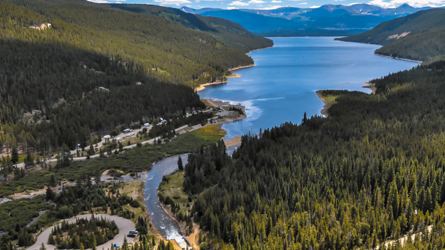
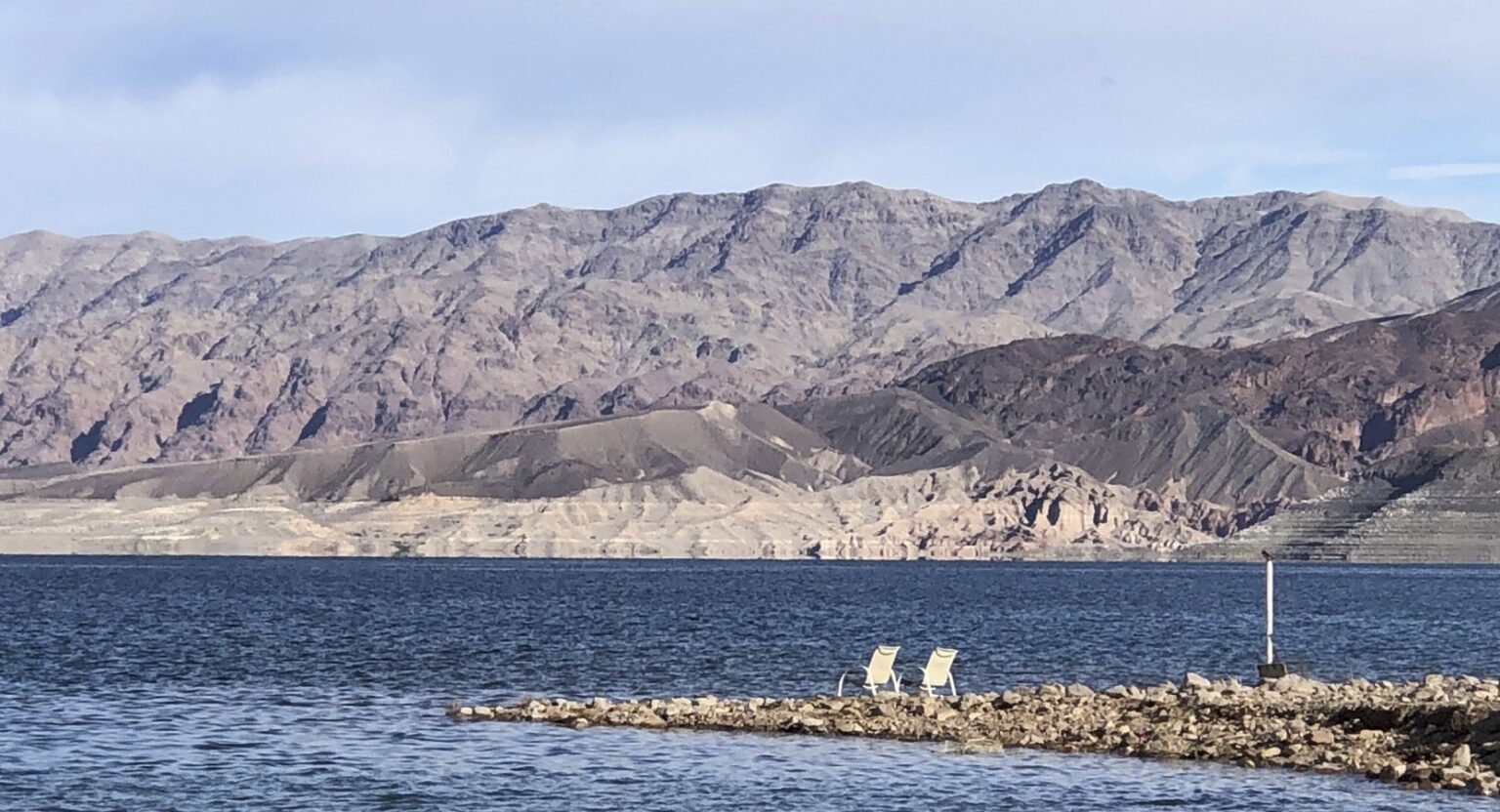
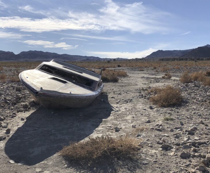
Water authorities in the Western U.S. donโ€™t have a crystal ball, but rapidly receding reservoirs uncovering sunken boats and other debris lost in their depths decades ago give a clear view of the hard choices ahead.

If western states do not agree on a plan to safeguard the Colorado River โ€” the source of the regionโ€™s vitality โ€” there wonโ€™t be enough water for anyone.

Water managers, researchers, agricultural producers and others from across the drought-stricken river basin met in Las Vegas last week for the Colorado River Water Users Association annual convention to face hard truths about the state of the river and historically-low levels of its biggest reservoirs.

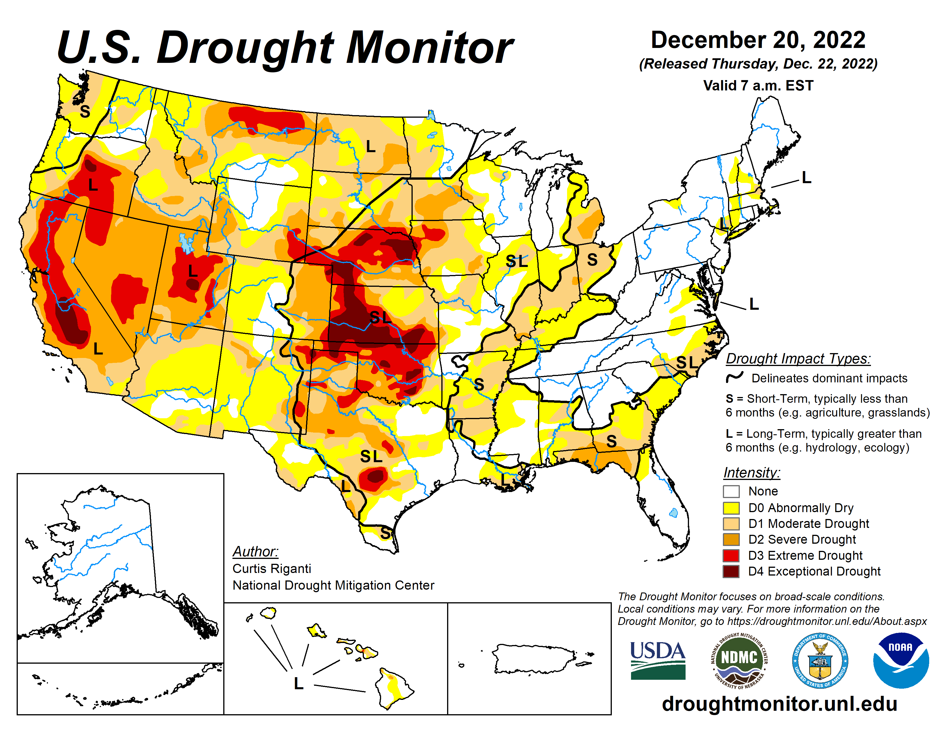
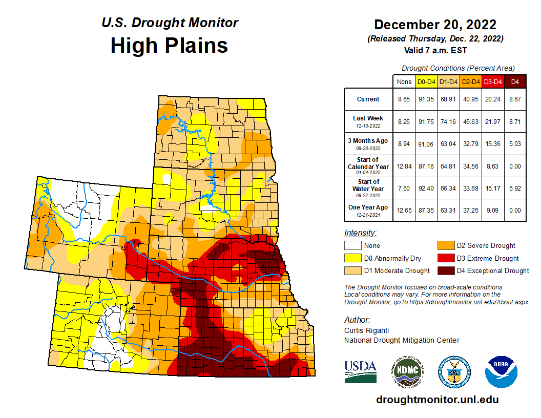
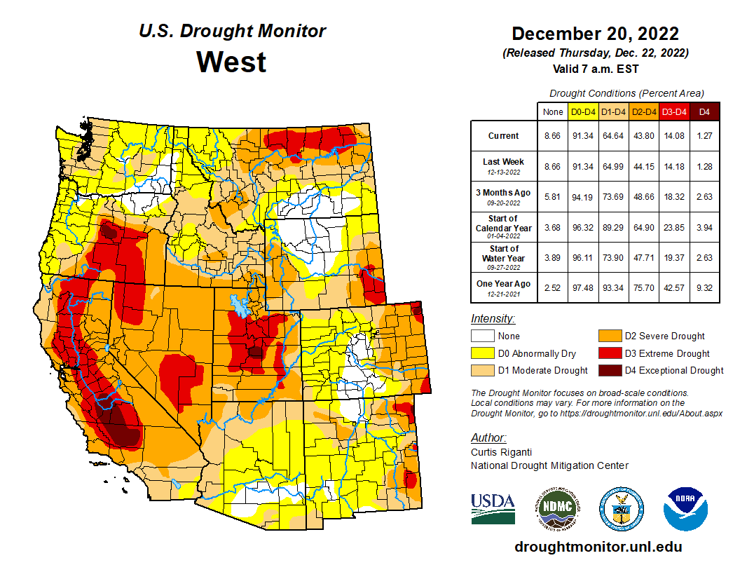
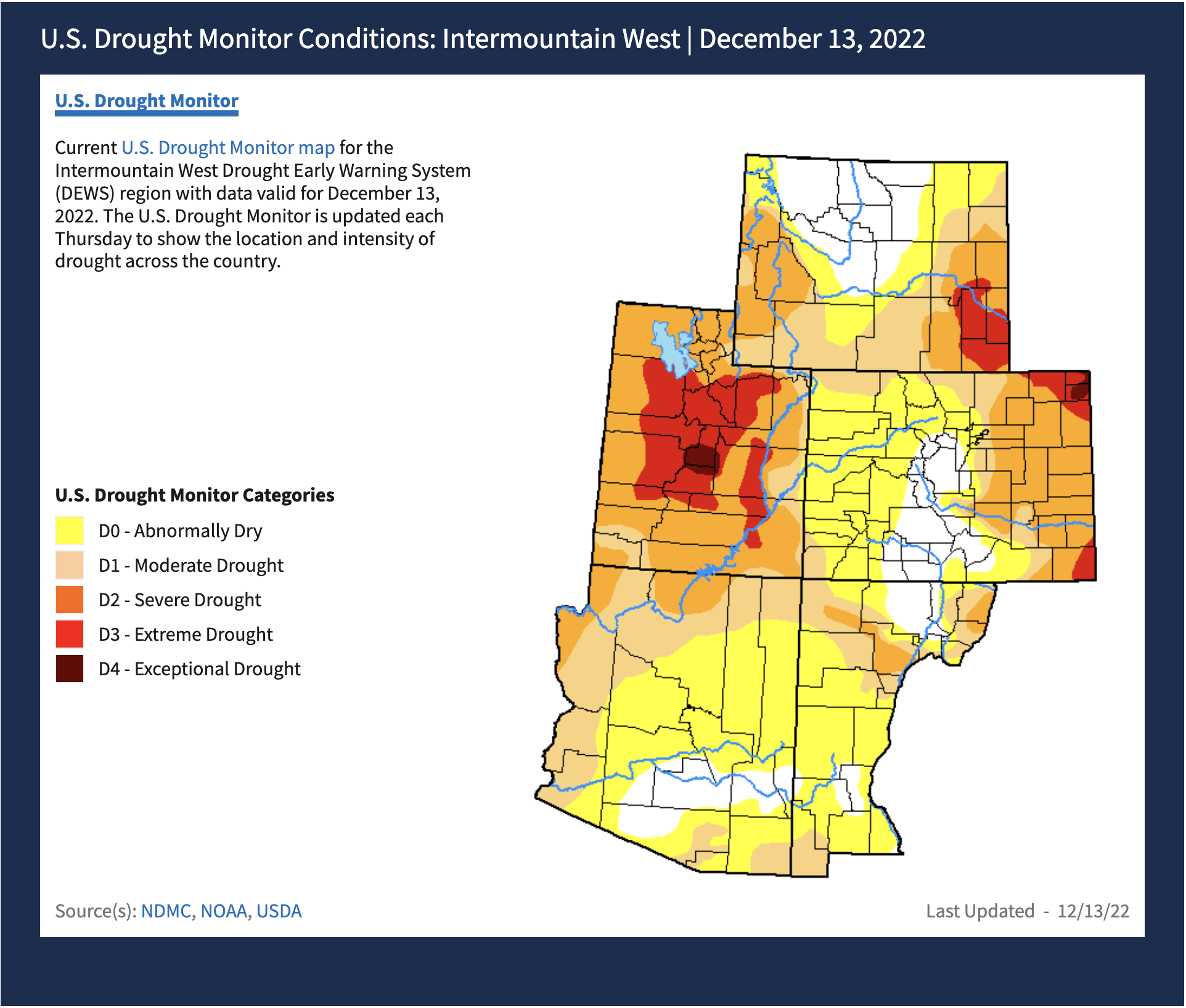
Two decades of drought and poor planning have caused the riverโ€™s biggest reservoirs โ€” Lakes Mead and Powell โ€” to drop to their lowest collective volume since they were filled.ย  [ed. emphasis mine]

โ€œTime is not on our side. Hydrology is not on our side. Thatโ€™s the frightening reality,โ€ said Rebecca Mitchell, director of the Colorado Water Conservation Board. The hydrology โ€œis going to force us to do something because we will have no other choices. Every day that passes this problem gets harder and harder to solve.โ€

Water storage in Lakes Mead and Powell is at a fraction of what it was two decades ago, and could drop below whatโ€™s needed to generate power as soon as next year, said water experts.

To put it in perspective, this winter both reservoirs were about a quarter full. In December 1999, Lake Powell was at 88% capacity, and Lake Mead was at 96% capacity, according to analysts.  

Lower basin states faced their first-ever federally declared water shortage, which directs how much states can draw from the Colorado River in 2021. Deeper cuts were subsequently declared this year.

Water experts say more water cuts for lower basin states โ€“ including Nevada โ€“ are likely in 2024 due to even lower water levels.

Even further restricting water allocation โ€œdoesnโ€™t mean the lakes wonโ€™t go lower than that,โ€ said Ted Cooke, the general manager for the Central Arizona Project.

If nothing is done, there is a real possibility water levels in both reservoirs will drop so low in the next two years that water will no longer flow downstream to the 40 million people in the West who rely on the Colorado River.

Colorado Water Conservation Board Executive Director and commissioner to the Upper Colorado River Commission Becky Mitchell, center, speaks on a panel with representatives of each of the seven basin states at the annual Colorado River Water Users Association conference in Las Vegas Thursday. The UCRC released additional details of a water conservation program this week. CREDIT: HEATHER SACKETT/ASPEN JOURNALISM

Faulty numbers and an over-allocated river

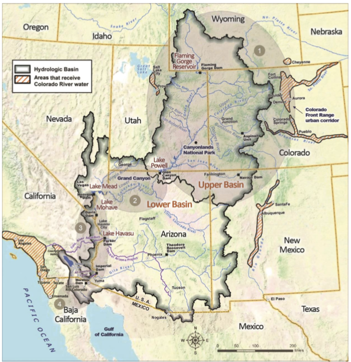
At the center of discussions last week was one of the most important legal documents governing how the riverโ€™s waters are shared: the 1922 Colorado River Compact, which allocated 7.5 million acre-feet for each basin, based on a faulty model that assumed the river system could supply 15 million acre-feet annually.

Today, officials acknowledge only 12.4 million acre-feet flows from the river each year, meaning western states will have to agree on massive cuts to their water supply for the sake of the river โ€” a politically perilous decision.

Despite clear evidence of diminishing water supplies over the past century, not much has changed in terms of how states allocate and use water.

But those in charge are starting to understand that western states are getting to a tipping point that will force them to adjust their attitudes and change their consumption habits.

In June, Bureau of Reclamation Commissioner Camille Touton issued an ultimatum to states: Develop a plan to save 2 million to 4 million acre-feet of water by next year โ€” roughly one-fifth of the water currently allocated to statesโ€”or the federal government will step in.

During a panel discussion at last weekโ€™s convention in Las Vegas, representatives for the seven western states who rely on the Colorado River said reaching a compromise will be their collective priority for the next six months.

They agree that the longer it takes to stabilize the river and conserve the water needed to keep the river functional, the more likely reservoir levels will continue to plummet, leaving states with fewer and fewer options.

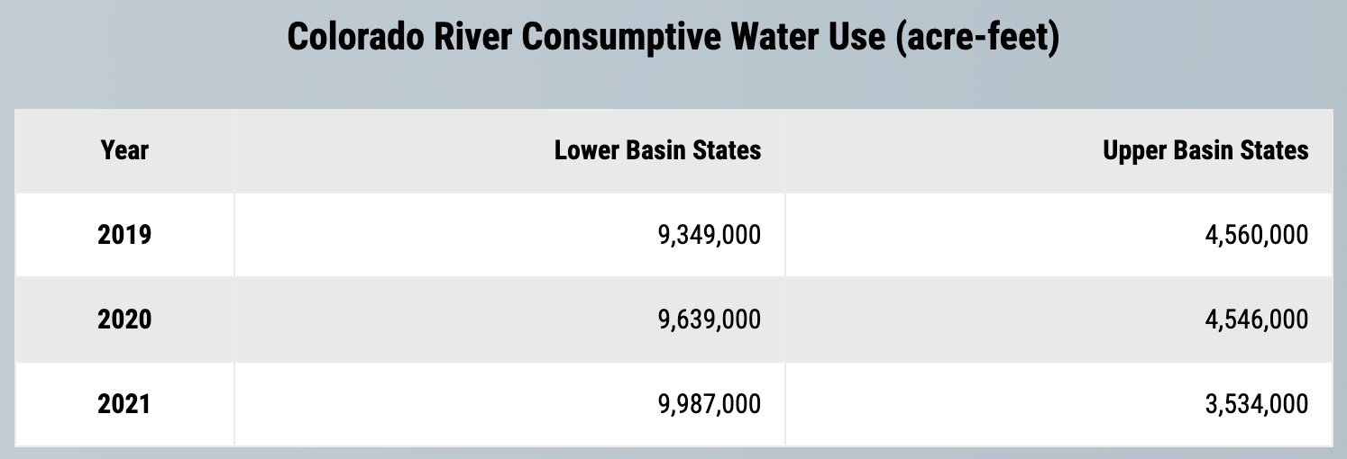
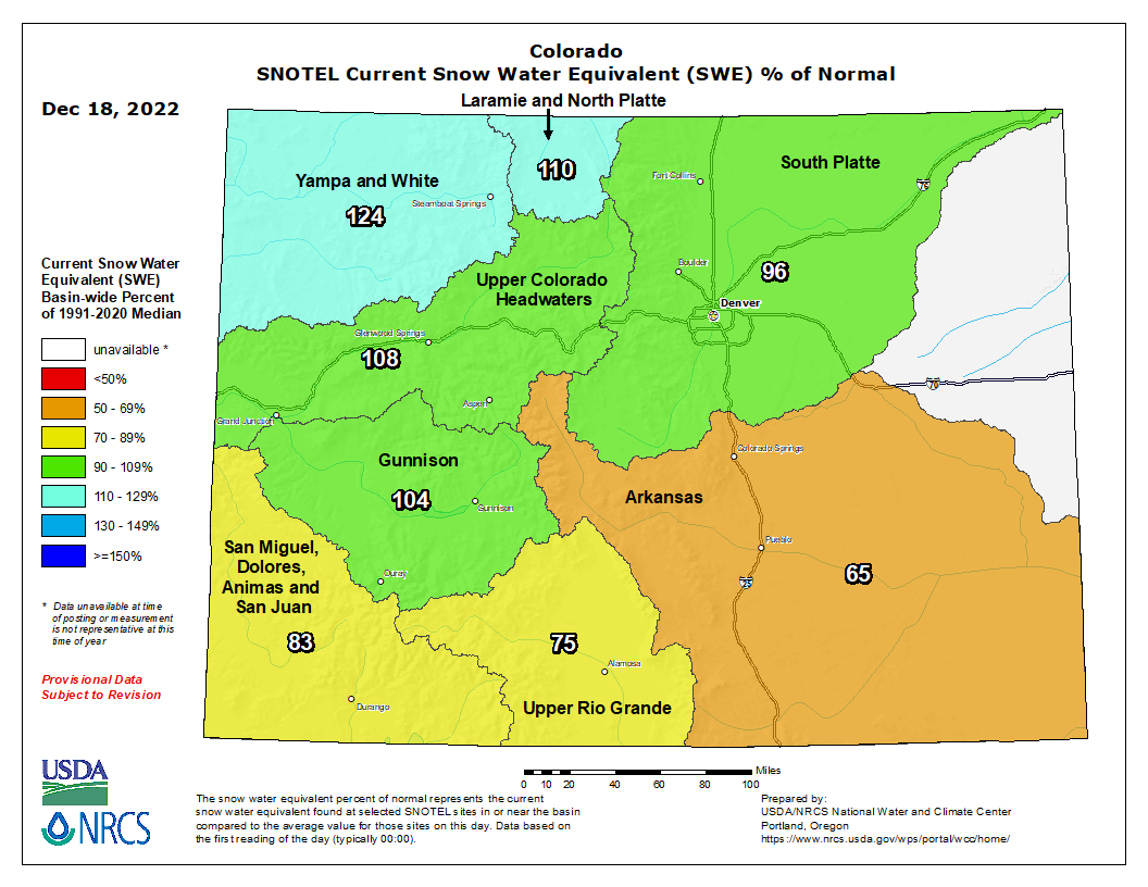
Water managers also agree that about 75% of future water cuts will need to come from lower basin states โ€” including Nevada โ€” to reach reductions large enough to protect critical elevations in the reservoirs.

Lower basin states โ€” Nevada, Arizona, and California โ€” use nearly all their 7.5 million acre-feet Colorado River allocation compared to the 4.5 million acres-feet used by the upper basin states, said water managers.

โ€œYes, the lower basin will have to take the lionโ€™s share of the reductions,โ€ said John Entsminger, the general manager of the Southern Nevada Water Authority. โ€œIโ€™m a big believer in the law, Iโ€™m a big believer in food security, but Iโ€™m an even bigger believer in math.โ€

Nevada uses only a small share of the riverโ€™s water and has made great strides in conservation, but Arizona and California are still far from a deal. Both states will need to make painful reductions and incur massive expenses to stabilize their water use, say water experts.

Just last week, all of Southern California was declared to be in a drought emergency by the Metropolitan Water District, the main water supplier for Los Angeles county.

Lower basin states argue that upper basin states โ€” Colorado, Wyoming, Utah, and New Mexico โ€” also need to make a firm commitment to lower their water use.

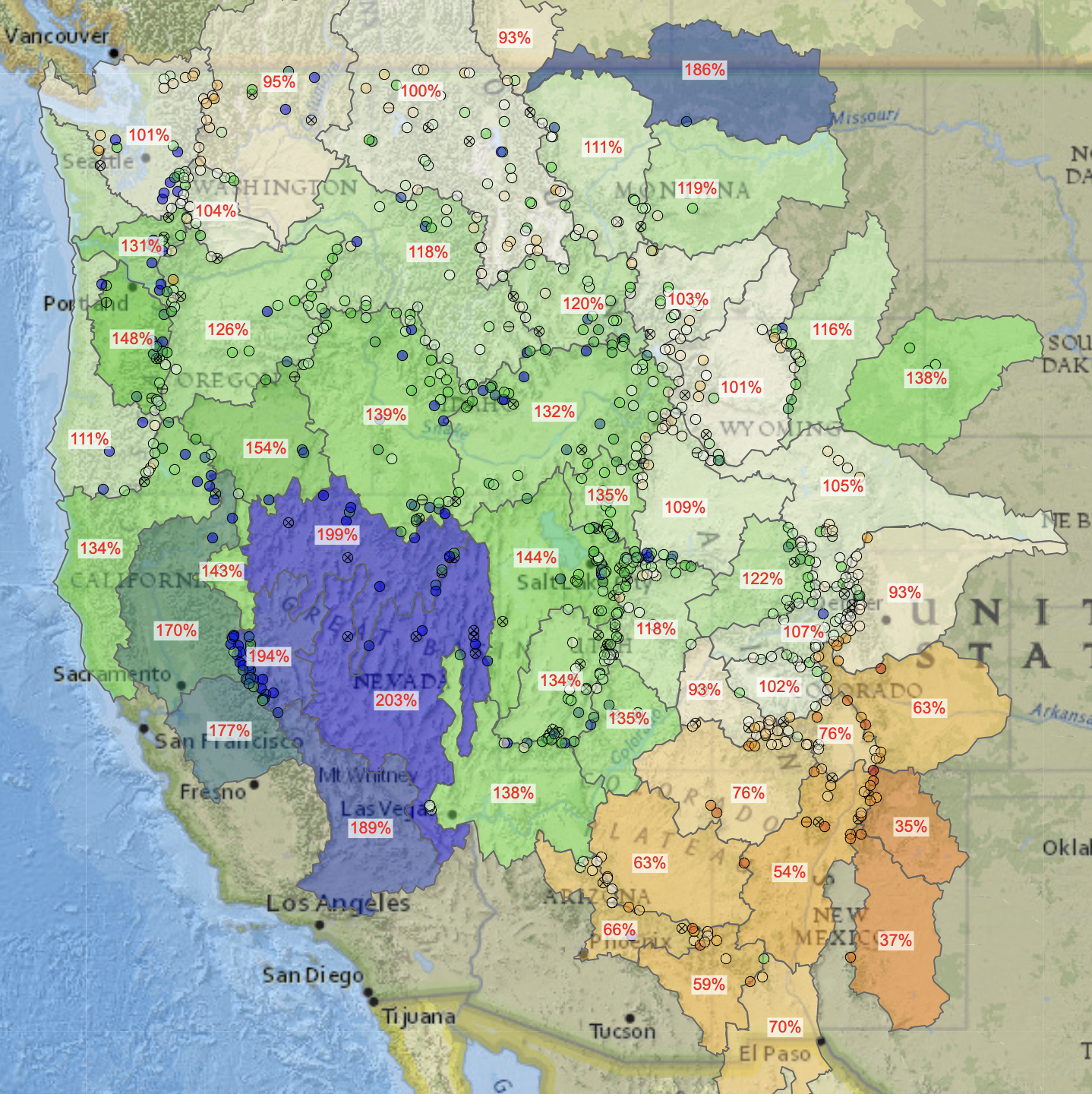
Officials for the U.S. Bureau of Reclamation warned that aridification, the long-term shift to a drier climate, means even less snow runoff is making it to the river each year.

โ€œItโ€™s really hard to come up with solutionsโ€ based on who has priority water rights, said Tom Buschatzke, director of the Arizona Department of Water Resources. If cities in lower-basin states โ€œwipe out every drop of their water, itโ€™s still not going to stabilize the system,โ€ said Buschatzke.

The upper basin has committed to looking into the feasibility of cutting back their water use โ€” a move critics say amounts to โ€œplanning to make a plan.โ€

Upper basin states have not released an estimate of how much water they are able or willing to cut. However, the Upper Colorado River Commission says they are slowly taking steps to create a management plan with potential water cuts.

โ€œWe live within the means of the river every day,โ€ said Becky Mitchell, the director of the Colorado Water Conservation Board. โ€œWhat we like to do is under-promise and over-deliver, and make sure if there is a number out there it is a number that can actually be achieved.โ€

Reservoirs in upper basin states are currently providing what amounts to 19% of their annual water usage to Lake Powell, based on a 2019 drought response agreement.

โ€œThose releases have had significant impacts, huge impacts on the local communities,โ€ Mitchell said. โ€œWhat youโ€™re asking for is a big ask. We are willing to look at this, but we also need to look at the impacts at the same time.โ€

Water managers representing the four upper basin states released details of a temporary conservation plan last week.

One critical component of the plan is the reauthorization of the System Conservation Pilot Program, a program that paid water users to reduce their use, with the goal of implementing it by the summer.

Itโ€™s unclear how much water the pilot program will successfully conserve as a voluntary and temporary solution. The original program saved about 47,000 acre-feet of water at a cost of about $8.6 million over the four years.

โ€œThe System Conservation Pilot Program is called a pilot program for a reason,โ€ said Gene Shawcroft, general manager of the Central Utah Water Conservancy District. โ€œWe believe we will learn a lot from that. We believe that it can easily be transitioned into a management plan.โ€

โ€˜This is going to be painfulโ€™

Brandon Gebhart, the top water official in Wyoming, said previous conservation programs that depend on voluntary cuts were not as effective as water managers had hoped, but a recent shift in mentality among water users could make the difference.

Another change that could make the difference is the nearly $4 billion set aside for the Colorado River that would allow the Bureau of Reclamation to pay users to voluntarily forgo water use.

โ€œThere are positives. The funding that is coming in provides opportunity. It provides the ability to change,โ€ said Mitchell, the director of the Colorado Water Conservation Board. 

Still, water managers say the federal government will need to invest even more money into the river.

โ€œIf you look at the federal investment in Florida, after one hurricane they got an order of magnitude more federal assistance than the entire Colorado basin is getting in the face of this crisis,โ€ said Entsminger, the Southern Nevada Water Authority general manager.

Western states will need all the assistance they can get to find ways to run their economies with less water, and time is running out.

A recent survey by the American Farm Bureau Federation found that more than 650 farmers in 15 Western states saw a 74% reduction in harvests, and 42% switched crops due to the drought.

It took Western states five years to agree on a short-term five year plan to address the region-wide drought that is set to expire in 2026, said Entsminger.

โ€œWe donโ€™t have five months to come up with an operation plan for 2023,โ€ Entsminger said. โ€œItโ€™s time to set aside the talking points and get real.โ€

Climate change has shrunk the riverโ€™s flows roughly 20% in the past two decades, and scientists predict they will shrink nearly 10%  more with each additional degree of temperature rise.

โ€œWe have to move quickly and weโ€™re committed to that,โ€ said Mitchell. โ€œWe need to accept the situation weโ€™re in and we need to reduce demands. All of us, every sector, every state, every water user. There isnโ€™t any other way.โ€

โ€œWe have to accept that we can not cling to our entitlements or allocations. If they are not there none of it matters,โ€ Mitchell continued. โ€œFolks in the room have to be willing to let us make hard decisions, because this is going to be painful.โ€

Nevada Current is part of States Newsroom, a network of news bureaus supported by grants and a coalition of donors as a 501c(3) public charity. Nevada Current maintains editorial independence. Contact Editor Hugh Jackson for questions: info@nevadacurrent.com. Follow Nevada Current on Facebook and Twitter.

Updated Colorado River 4-Panel plot thru Water Year 2022 showing reservoirs, flows, temperatures and precipitation. All trends are in the wrong direction. Since original 2017 plot, conditions have deteriorated significantly. Brad Udall via Twitter: https://twitter.com/bradudall/status/1593316262041436160

Why Scientists Are Rallying to Save Ponds: Humble ponds have a key role to play in fighting #climatechange and aiding conservation โ€” but only if we protect them — The Revelator

โ€œSwamp Cedarsโ€ (Juniperus scopulorum) and associated pond, wetland and meadow in Spring Valley, White Pine County, Nevada. Photograph by Dennis Ghiglieri from http://images.water.nv.gov/images/Hearing%20Exhibit%20Archives/spring%20valley/WELC/Exhibit%203030.pdf

Click the link to read the article on The Revelator website (Jack McGovan):

Thomas Mehnerโ€™s research team has spent the past few years wading through ponds in Brandenburg โ€” the state surrounding Germanyโ€™s capital city, Berlin. It wasnโ€™t the increasingly hot summers that forced them into the cool water. They were collecting samples for analysis โ€” something not many other people are doing.

โ€œNortheast Germany is blessed with lakes, so if you talk with people about ponds, they say, โ€˜Are they so important?โ€™โ€ says Mehner, a researcher at the Leibniz-Institute of Freshwater Ecology and Inland Fisheries in Friedrichshagen, Berlin.

The answer, it turns out, is yes.

Ponds take so many forms across the world that the word โ€œpondโ€ can be quite difficult to define. Typically, however, theyโ€™re smaller and shallower than lakes. As to their importance, research suggests that ponds are better for biodiversity than many larger bodies of water. Theyโ€™ve been found to support more plants and animals overall, including many endangered species.

Thatโ€™s part of what guides Mehnerโ€™s research on ponds. His team gathers information on insect larvae and environmental DNA to detect the presence of fish and amphibians. They also collect traces of greenhouse gases like methane and carbon dioxide to examine the link between the biodiversity of water bodies and its impact on emissions in the environment.

Their work is part of a larger effort.

Mehner is the German partner for POND Ecosystems for Resilient Future Landscapes in a changing climate โ€” PONDERFUL, for short. The international project examines hundreds of ponds across Europe โ€” and beyond โ€” to see how they can help provide climate change solutions and boost conservation.

But for these often-ignored water bodies to help us and support wildlife, researchers say ponds also need protections.

Establishing Safeguards

Ponds can be just as diverse as the ecosystems they support. In Germany, for example, ponds were typically carved out by glaciers during the last ice age, says Mehner. In the United Kingdom, they were largely excavated by farmers for rearing cattle. Some ponds are a permanent fixture of the landscape, while others only exist during certain periods of the year.

Regardless of their origins, ponds have helped provide refuge for wild animals and plants. Unfortunately, despite decades of research showing pondsโ€™ importance to biodiversity, theyโ€™re often overlooked by policymakers and the public.

The current policy that covers standing waters in the U.K. and European Union โ€” the EU Water Framework Directive โ€” largely excludes bodies of less than 50 hectares.

As a result, ponds are essentially ignored, which means theyโ€™re not monitored by authorities and are allowed to languish, blocking potential climate and biodiversity benefits.

PONDERFUL hopes to change this. One of its major goals is to gather data that can be shared with policymakers to highlight the importance of ponds so theyโ€™re given more attention.

A PONDERFUL project in Switzerland. Photo: Julie Fahy (CC-BY-NC-ND)

Disappearing Ponds

Time is of the essence.

Some of the ponds that Mehner studies are located in the small municipality of Schรถneiche, on the border of Berlin and Brandenburg, where ponds are disappearing.

โ€œThis is really a reflection of climate change,โ€ he says. The lack of rain in recent years has depleted the ponds, which also suffer from urban pressures. Berlin consumes a lot of groundwater from surrounding areas, further pushing the groundwater-fed ponds to the breaking point.

This isnโ€™t an isolated problem.

Research from the Swiss Federal Institute of Aquatic Science and Technology found that 90% of ponds in Switzerland have been lost over the last two centuries. The U.K. had an estimated 800,000 ponds at the start of the 20th century; today less than a quarter of those remain. In Austria, researchers found that 70% of temporary saline ponds were lost over a 60-year period.

Unlike in Brandenburg, in these countries the loss of ponds has been linked to agricultural intensification, with farms either filling in the ponds, ploughing over them or draining them.

Global Action

Whatever the reason for their perilous states, researchers hope that better data can help guide government policy.

Thereโ€™s evidence elsewhere that it can.

Elias Bizuru, director of research and innovation at the University of Rwanda, helped to build the Rwanda Biodiversity Information System. Starting in 2018, researchers collected data from wetlands and other freshwater habitats and made it all available on one system.

โ€œThe information related to biodiversity in Rwanda was scattered across institutions, and getting that information was a very, very big challenge,โ€ says Bizuru. Without the information at hand, researchers like himself found it difficult to make suggestions on the kind of actions decisionmakers should take to protect wetlands.

When they do have easily accessible data, Bizuru says, the Rwandan government can be quite successful in its interventions. The Nyandungu Eco-Tourism Park, for example, was a degraded wetland six years ago. Now, after a restoration project, itโ€™s host to a wide range of native species, including dragonflies, snakes, amphibians, birds and a range of plants.

Another restoration project in Switzerland created hundreds of new ponds and managed to increase the regional populations of eight endangered frogs, toads and newts, especially helping the European tree frog. The effort helped boost those regional populations by 52%.

In the U.K., the Norfolk Pond Project has conducted similar work. Carl Sayer and Helen Greaves, colleagues in the geography department at University College London, have together helped to restore more than 200 ponds originally dug for agricultural purposes.

To restore them, Sayer and Greaves would simply clear up mud and remove trees from the area, letting nature do the rest. Aย study published by the pairย in 2020 highlighted significant increases in aquatic plants, invertebrates and amphibians after their interventions.

A European tree frog. Photo: Nicholas Turland (CC BY-NC-ND 2.0)

โ€œYouโ€™re almost reinstating natural processes, really, because in a natural state ponds are disturbed,โ€ Sayer says.

Cascading Effects

Ponds donโ€™t only exist in rural areas.

Zsรณfia Horvรกth, a community ecologist at the Institute of Aquatic Ecology in Budapest, runs a citizen science campaign for ponds in urban areas across Hungary. Her research team has collected biodiversity data from 386 ponds and surveyed more than 800 pond owners to find out which interventions people can take to make their ponds more biodiverse.

During a previous research project in Austria, she found that if one pond disappears, others suffer.

She tells me that ponds function for the species they host the same way islands might for humans at sea. The more islands are lost, the more precarious it becomes for a seafarer to access the resources they need to survive.

โ€œYouโ€™re taking out these important members of the network,โ€ she says. Their research looked into zooplankton populations โ€” crustaceans and rotifers โ€” since the 1950s and found that species loss correlated with a reduction in the number of ponds in the area.

The idea that itโ€™s important to create networks of ponds is also shared by Sayer, and itโ€™s a long-term goal of the Norfolk Pond Project.

โ€œIโ€™d love to see whole areas joined, where we restore ponds in one landscape and another, and then we link it all up,โ€ he says.

Ensuring such networks become a reality, however, requires more data, Horvรกth says.

โ€œItโ€™s so easy to ignore a habitat if you donโ€™t know what kind of service it can offer humanity,โ€ she says. โ€œItโ€™s kind of a very profane, human-oriented point of view โ€” but this is how policymakers and the general public work.โ€


Get more from The RevelatorSubscribe to our newsletter, or follow us on Facebook and Twitter.

San Diegoโ€™s Zombie Water Pipeline Project Is Dead Again. For Now — The Voice of San Diego #ColoradoRiver #COriver #aridification

Colorado River “Beginnings”. Photo: Brent Gardner-Smith/Aspen Journalism

Click the link to read the article on The Voice of San Diego website (MacKenzie Elmer):

San Diegoโ€™s proposal to build its own $5 billion pipeline to the Colorado River and bypass paying Los Angeles for water is now in a state of the undead โ€“technically lifeless unless local water officials choose to revive it again.

The San Diego County Water Authority last resurrected the idea to build its own pipeline from the major water source in September 2020. It was an effort to free its dependence on the Los Angeles Metropolitan Water District, which owns the only aqueduct โ€“ and San Diegoโ€™s only connection โ€“ to the Colorado River.

Dan Denham, the Water Authorityโ€™s deputy general manager, confirmed Thursday that itโ€™s โ€œpencils downโ€ on the water wholesalerโ€™s sixth attempt to study the pipeline project since the 1990s. The reason this time is that Water Authority is in court with Metropolitan over what LA charges to transport almost 60 percent of San Diegoโ€™s water, but thereโ€™s hope for common ground.

โ€œI think both parties are willing and ready to sit down and talk about a settlement,โ€ Denham said.

A San Francisco court is expected to rule early next year on whether San Diego should be credited for water it used to buy from Metropolitan but now purchases from the Imperial Valley โ€“ though it all flows through the same straw from the Colorado River owned by Los Angeles. Denham said theyโ€™re stepping back from pursuing a parallel pipeline over hopes for either a settlement or a court win.

โ€œI know five billion sounds like a lot of money, and it is, but when you talk about what (weโ€™re) paying to get the water here in todayโ€™s dollars, over time thereโ€™s an economic argument that can be made (for it),โ€ Denham said.

Consultants hired by the Water Authority to study the zombie pipeline predicted Los Angelesโ€™ water and transportation rates would be so high in the future, San Diego could get river water through its own straw by 2048 at $1,000 less than Metropolitan would charge. Currently, though, water from Metropolitan is San Diegoโ€™s cheapest supply.

San Diego took LA to court in 2010 alleging Metropolitan tacked costs on top of that Imperial Valley deal that the Water Authority customers shouldnโ€™t have to pay. Bad blood over the cuts San Diego experienced during the drought and subsequent fights over the Imperial Valley water deal fueled the resurfacing of the parallel pipeline โ€“ an effort to break from Metropolitan completely.

Metropolitan officials didnโ€™t publicly view San Diegoโ€™s project as a threat. Former General Manager Jeffrey Kightlinger said he was โ€œagnosticโ€ to it when it was reintroduced two years ago. San Diego is one of Metropolitanโ€™s biggest customers and, losing those sales would leave the rest of Los Angelesโ€™ customers to pay for maintenance of it sprawling system, but Kightlinger said there was plenty of time to plan for the departure in the years it would take San Diego to execute the project. General Manager Adel Hagekhalil declined to comment for this story.

JB Hamby, a director on Imperial Valley Irrigation Districtโ€™s board, said a member of the Water Authority board recently assured him the pipeline was dead. Hamby called for San Diego to stop its pursuits of the parallel pipeline in YouTube videos during his 2020 campaign. He sees its renewed demise as a positive sign San Diego and Los Angeles are playing nice.

โ€œYouโ€™ve had turnover on the board, the general manager and chairpersons โ€ฆ Thereโ€™s a reset thatโ€™s happened between the two agencies thatโ€™s very healthy and promising for the future,โ€ Hamby said.

San Diego has long blamed Los Angeles for water rate increases. The region used to buy all its water from Los Angeles until a drought and mandatory water cuts in the 1990s encouraged the Water Authority to diversify its sources. San Diego still gets most of its water from the Colorado River through the same set of pipes connecting the region to Los Angeles, but who they buy it from has changed.

A huge 2003 deal with Imperial Valley means San Diego now buys much of its river water from their eastern neighbor, and the money isย used to pay farmers and support Imperialโ€™s utility. Farmers donโ€™t physically send the water westward through canals or pipes to make that exchange. San Diegans are instead consuming โ€œpaper water,โ€ as itโ€™s known in the water world, or a legal instrument used to track who is paying for and consuming water molecules circulating throughout the West.

The Water Authorityโ€™s governing board approved $1.8 million to re-study the parallel pipeline by a slim margin in November 2020.

That duplicate pipe San Diego wanted to build would sit parallel to the one Met uses now and wouldnโ€™t produce any savings for ratepayers until at least 2063 โ€“ costing two generations of ratepayers at least $5 billion to build. The Water Authority estimates the pipe could save ratepayers other billions โ€“ eventually.

The Water Authority studied the pipe dream at least five other times in the past. The route it was most excited about was the same one it ditched in 1996 because it was more expensive than the others at that time.

The route stretches 132 miles from the southern tip of the Salton Sea, along state Route 78 through Anza Borrego State Park. It would tunnel underneath the Volcan Mountains, Mesa Grande Reservation and Cleveland National Forest, along the northern border of San Pasqual Reservation, eventually terminating at the Twin Oaks Valley Water Treatment Plant.

Proponents argued it would give San Diego control over its water infrastructure costs, the primary driver of ever-rising water rates. Critics didnโ€™t understand why San Diegans should spend billions on a project that wouldnโ€™t bring any new water to the region.

Tom Kennedy, general manager for Rainbow Municipal Water District in northern San Diego County, which is currently undergoing its own separate fight to divorce from the Water Authority due to high water costs, argued the pipeline would make San Diego too dependent on the Colorado River.

If San Diego built its own pipeline to the Colorado River, Kennedy said, then it couldnโ€™t benefit from other water that Metropolitan provides Southern California from rivers in Northern California.

โ€œI think putting all your eggs in a basket on the Colorado River is a bad idea,โ€ Kennedy said. โ€œWhy would you spend billions of dollars on one supply?โ€

Denham said if the Water Authority board chose to pick up the project again, it would have to re-do all the cost estimates of the project since inflation has driven up construction and labor prices since the boardย paid a consulting firm just under $2 millionย to study the idea.

This story was first published byย Voice of San Diego. Sign up forย VOSDโ€™s newsletters here.

The Year in Water, 2022: #ColoradoRiver Basinโ€™s Moment of Reckoning — Circle of Blue #COriver #aridification

Updated Colorado River 4-Panel plot thru Water Year 2022 showing reservoirs, flows, temperatures and precipitation. All trends are in the wrong direction. Since original 2017 plot, conditions have deteriorated significantly. Brad Udall via Twitter: https://twitter.com/bradudall/status/1593316262041436160

Click the link to read the article on the Circle of Blue website. Here’s an excerpt:

It was perhaps the shock that Colorado River users needed.

A basin that is spending down its water savings was jolted in June when the U.S. government ordered the seven states to correct a longstanding misalignment of water supply and demand.

Camille Touton, commissioner of the Bureau of Reclamation, told the states to cut their take from the river next year by between two million and four million acre-feet of water. At the high end, that equals one-third of the Coloradoโ€™s recent annual flow. Unless the states acted, she said, the federal government would โ€œprotect the systemโ€ and apply its own remedy.

John Entsminger, the head of the Southern Nevada Water Authority, which supplies the Las Vegas area, affirmed the groundbreaking nature of the pronouncement. The requested conservation volumes, he said, were of a magnitude โ€œpreviously considered unattainable.โ€

They still havenโ€™t been attained. The states missed an August deadline and remain in fractious negotiations about how to divide the cuts.

Lake Mead, absent unprecedented action or a miraculous winter, remains in peril. It is projected to shrink more than 20 feet by the end of 2023, when the reservoir would be just 22 percent of capacity.

Reclamation awards $80,000 for improved precipitation measurement devices

SNOTEL automated data collection site. Credit: NRCS

Click the link to read the release on the Reclamation website (Chelsea Kennedy):

The Bureau of Reclamation selected eight solutions to each receive $10,000 and continue in the Counting Every Drop Challenge. This challenge is seeking precipitation measurement devices that are reliable, accurate, low maintenance, and able to operate in remote areas in extreme weather conditions.  

The Counting Every Drop Challenge is a two-phase prize competition totaling up to $300,000 in prizes. The ideal solution will not require fluids, such as antifreeze, to operate.  

“Better precipitation monitoring stands to enhance water management. We are excited by the innovative concepts of the phase one winners and look forward to how they progress and perform in phase two,” said Senior Advisor for Research and Development Levi Brekke. “The goal of this prize competition is to develop new devices that increase accuracy and reliability while reducing maintenance so they can operate cost-effectively in extremely remote areas.” 

The winning solutions selected to move onto phase two include: 

  • Rixel – Their solution is a fluid-free and active precipitation station that measures any form of precipitation. It can operate in harsh environments from extreme cold to hot. The eco-friendly design discharges only water into the environment. 
  • The Planet Earth – Their solution is a fluid-free precipitation metering device that includes a pot that is mounted on a load cell. After completing the precipitation weighing process, the precipitation will be discharged into the environment using a wiper that cleans the pot continuously.โ€ฏ 
  • Orion Labs -Their system provides a fluid-free solution for accurate precipitation detection and measurement and builds upon existing rain gauge collection methods, adds enhancements with software capabilities, and a custom-designed collection unit for a unique, low-power, low-cost redundant solution.    
  • PGRAWS – Their Precipitation Gauge with Redundant Array of Weight Scales known as PGRAWS is a novel catching-style precipitation gauge based on weight measurement of all forms of precipitation. Redundant collection buckets with independent mechanical operation contribute to high instrument reliability. 
  • PMASS – The Precipitation Measurement with Advanced Solid-state Sensors solution, known as PMASS combines a downward-facing pulsed coherent radar, a camera-based sensor, and a temperature sensor. The machine learning solution estimates rates and accumulated depth of precipitation from features extracted from the radar and camera subsystems. 
  • Rahavi Brothers – Their device benefits from the massive energy stored in propane. We use this energy to melt solid precipitation during extremely cold weather. An AI-powered control board is responsible for controlling the process to increase accuracy and performance. 
  • Top Solvers โ€“ Their device uses an array of precipitation sensors together with a custom control unit. Whichโ€ฏmeets and exceeds all the challenge requirements, providing the required accuracy and fail-safe redundancy. 

The selected teams will build their prototype and a preliminary review will be conducted during this phase. Up to five of the eight teams will receive $15,000 to continue prototype development during this phase. Teams that ship their prototype for testing will receive a $3,000 milestone award. The top solution that meets all the requirements and is fluid free will receive $100,000. Other solutions will share $30,000 in innovation awards. 

Reclamation is partnering with the USDA Natural Resources Conservation Service, NASA Tournament Lab, Geonor, Inc., and Freelancer for this prize competition. 

To learn more, please visitโ€ฏwww.usbr.gov/research/challenges/counteverydrop.html. 

Reclamation conducts prize competitions to spur innovation by engaging a non-traditional, problem-solver community. Please visit Reclamation’sโ€ฏWater Prize Competition Centerโ€ฏto learn more. 

Should we worry about 8 billion people? Breaking down populationโ€™s role in the environmental impact equation — @HighCountryNews

Click the link to read the article on the High Country News website (Jonathan Thompson):

This is an installment of the Landline, a fortnightly newsletter from High Country News about land, water, wildlife, climate and conservation in the Western United States. Sign up to get it in your inbox.

Is overpopulation the environmental elephant in the room?

Last month, the United Nations announced that the Earthโ€™s population had reached 8 billion. The organizationโ€™s leaders donโ€™t see all those humans as something to fear, but rather as, in the words of Secretary General Antรณnio Guterres, โ€œan occasion to celebrate diversity and advancements while considering humanityโ€™s shared responsibility for the planet.โ€

But judging from the letters I get after almost every environment-related piece I write, I suspect that some readers would disagree. 

โ€œI am an avid โ€˜environmentalist,โ€™โ€ a reader recently wrote. โ€œSimple, plain truth fact: Whether it is climate change, wildlife habitat, immigration, and yes, even gun violence. We will NEVER make much progress โ€ฆ until we make significant gains in stabilizing and ultimately reducing the cancer of human population growth.โ€

This note echoes hundreds of other responses Iโ€™ve received over the last couple decades. The basic idea is that all aspects of environmental degradation โ€” along with traffic congestion and the housing crisis โ€” are rooted in overpopulation. And, the argument goes, not mentioning this in environmental stories is irresponsible, verging on dishonest. โ€œPopulation growth is the environmentalistsโ€™ โ€˜elephant in the room,โ€™โ€ another reader wrote. โ€œWe ignore the issue at our peril.โ€

We at Landline would like to use the 8-billion benchmark as an opportunity to stop ignoring population. But, fair warning: You might not like what we have to say.

No, Iโ€™m not going to tell you to stop worrying about population growth. Even as the U.N. celebrates the advances in medicine and nutrition that make it possible for billions of people to exist on Earth, it acknowledges the challenges presented by rapidly growing numbers in places like Nigeria. And no, Iโ€™m not going to deride every overpopulationist as a racist or eco-fascist or eugenicist. While itโ€™s true that fear of overpopulation is often used to justify racism or eco-fascist views or xenophobia, there are plenty of folks who are genuinely concerned about the planetโ€™s ability to sustain 8 billion people, no matter where or who or what color those people may be.

But I will suggest that youโ€™re barking up the wrong tree.

Most folks would agree that the real worry here is not the sheer numbers, but their collective impact on the environment. We โ€” the planetโ€™s human inhabitants โ€” are clearing land, leveling forests and mountains, mining and drilling minerals and burning fossil fuels in order to sustain ourselves and our lifestyles. That, in turn, is diminishing biodiversity, driving species to extinction and stretching the planetโ€™s carrying capacity to a snapping point, thereby imperiling our own speciesโ€™ survival. The problems are exacerbated as planet-warming greenhouse gas emissions soar, further diminishing freshwater stores and hurting food production. 

And the environmental impacts, put simply, are the product of population multiplied by per capita consumption. It would stand to reason that with every added unit of humanity comes a corresponding and proportional increase in environmental impact. The thing is, per capita consumption varies widely across the globe and the demographic spectrum, vastly outweighing simple population numbers in our impact equation. 

14
Percent by which total global energy consumption has increased over the last decade. 

11
Percent by which total global population increased during that same period. 

6
Percent by which total global carbon emissions from energy use increased over the decade.

That is to say, the affluent consume far more than everyone else and therefore have a much greater environmental impact, throwing the aforementioned equation into disarray. The richest 10% of the globeโ€™s population are responsible for nearly half of all โ€œlifestyle consumption emissions,โ€ according to Oxfam, while the poorest half is responsible for just 10% of those emissions. Another way to look at this is that each person at the top of the global wealth ladder emits about 31.25 metric tons of carbon dioxide-equivalent each year, while each of the globeโ€™s poorest 50% emits about 1.25 tons of CO2. Thatโ€™s because folks in the so-called โ€œdevelopedโ€ world burn through a heck of a lot more fossil fuels, food, water, minerals, Big Macs โ€” you name it โ€” than those in less-affluent, rapidly growing regions.

Increases in population still result in increases in overall environmental impact. But per capita consumption plays a far bigger role. Itโ€™s runaway consumption, not unhindered population growth, that is most responsible for the habitat loss, land-use changes and resource exploitation that most threaten biodiversity and cause the runaway greenhouse gas emissions that are altering the climate. 

4.7 billion
Metric tons of carbon dioxide emitted from energy use in the United States in 2021.

3.8 billion
Metric tons of carbon dioxide emitted by Europe energy use in 2021.

1.3 billion
Metric tons of carbon dioxide emitted by Africa from energy use in 2021.

This equation โ€” combined with the disproportional influence of consumption over sheer population numbers โ€” holds true even at a regional level. 

Perhaps the most prominent example of a system in the West that has exceeded the carrying capacity is the Colorado River. The population has dramatically increased in the seven Colorado River Basin states over the last few decades. And, during that same time, demand for the riverโ€™s water has come to vastly exceed the supply.

At first glance, it would appear that a larger population has resulted in greater consumption, thereby draining the reservoirs. But the data doesnโ€™t back this up. While Colorado River consumption climbed along with population for decades after the Colorado River Compact was signed a century ago, that demandย leveledย over the last couple of decades, even as the population exploded. Yes, consumptive use of the Colorado Riverโ€™s watersย held steady or even droppedย as the population climbed, as counterintuitive as that may seem.

The Bellagio fountains in Vegas. The fountain is fed by a private well from a now-defunct golf course, not by the Colorado River. Credit: Brent Gardner-Smith/Aspen Journalism

750,000
Amount by which the Las Vegas metro area population increased between 2002 and 2021. 

26 billion gallons
Amount by which the Las Vegas metro area overall water use decreased during that same period. 

500,000 acre-feet
Estimated amount of Colorado River water used to irrigate alfalfa fields in a single California irrigation district per year, or nearly twice the Las Vegas areaโ€™s total annual consumption.

Meanwhile, the Westโ€™s wealthiest guzzle more and more water and energy and resources with every new pile of cash (or cryptocurrency or stocks or yachts) they amass, from the Kardashians using hundreds of thousands of gallons of water per month to keep their Los Angeles-area estate verdant during the most severe drought in 1,200 years, to Drake burning through jet fuel to take a 14-minute trip in his custom 767, to an LA mansion with a $50,000 monthly electricity bill. Yes, $50k for electricity to keep the monstrosityโ€™s 105,000 square feet, or 217 average-sized Hong Kong homes, cool during the increasingly hot California summers.

Itโ€™s not just the billionaires. Americans in general tend to favor relatively giant automobiles and lawns and houses โ€” the average home size in Colorado Springs is almost 2,800 square feet. These, in turn, require more energy, wider roads, more water and lead to residential sprawl, which gobbles up farmland and open space and wildlife habitat. Bigger physical footprints almost always have bigger environmental footprints.

This isnโ€™t the result of 8 billion people on the planet or cross-border immigration. Itโ€™s the natural outcome of the dominant culture, which values affluence, economic growth and corporate profit above all else. Itโ€™s societal greed and an emptiness that always yearns for more, in part because corporate marketing schemes have convinced us that the more we accumulate, the happier we are. But Americans donโ€™t have the highest quality of life, they just lead the most profligate lives, throwing away enough food each year, for example, to feed an entire nation.

161 to 335 billion tons
Estimated amount of food wasted in the U.S. supply chain each year, which amounts to as much as 1,032 pounds per person.

140 million
Acres of land required to grow food that is wasted each year in the U.S.

5.9 trillion
Gallons of water used to grow food that is wasted each year in the U.S.

Trying to control the population โ€” whatever that might look like โ€” isnโ€™t going to solve those problems. Only a rejiggering of the system, a suppression of the collective capitalist appetite, a debunking of the belief that all growth is good and that more is more, will right the sinking ship weโ€™re on. [ed. emphasis mine]

As for the 8 billion, most experts say the best way to stabilize the global population is to empower and educate women, increase access to birth control, ensure that women have reproductive freedom and tackle wealth inequality.

Meanwhile, policymakers and thinkers and environmentalists should focus more on reducing consumption and changing what is consumed, especially by the affluent. Because when it comes to the environment, thatโ€™s the real elephant weighing down the planet.

#ColoradoRiver Basin Tribes Address a Historic #Droughtโ€”and Their #Water Rightsโ€”Head-On: Their growing inclusion in the regionโ€™s water management will likely prove priceless — Natural Resources Defense Council

On a day in late May [2022] wildfire smoke obscures the throat of an ancient volcano called Shiprock,. Ute Mountain Ute farming and ranching operation in the southwestern corner of Colorado. Photo credit: Allen Best/Big Pivots

Click the link to read the article on the Natural Resources Defense Council website (Tim Vanderpool):

A warm breeze slips down from Sleeping Ute Mountain, stirring fields of alfalfa and corn across the Ute Mountain Ute Tribe Farm & Ranch Enterprise in the arid flats of southwestern Colorado. The state-of-the-art farm, with its ultra-efficient drip irrigation, satellite-guided tractors, and sought-after Bow & Arrow brand of non-GMO cornmeal, is an intense source of pride for the 2,000-member Ute Mountain Ute Tribe. Itโ€™s also an important income source for its 553,000-acre reservation in the Four Corners Region, where Arizona, Colorado, New Mexico, and Utah meet.

In normal times, the enterprise employs several dozen tribal members and distributes more than $1 million in paychecks annually. But these are not normal times. The epic Southwest drought, whose severity has been fueled by climate change, has hit the farm hard. Today, it scrapes by on just 10 percent of the water normally flowing along a clay canal from the McPhee Reservoir. As a result, corn harvests have been cut by 75 percent, and half of the 50-person workforce, mostly tribal members, were laid off. Overall, the tribe lost an estimated $4 million to $6 million in the last year alone. Now, longtime general manager Simon Martinez squeezes everything he can from a drop of water. โ€œWe canโ€™t do any more than that,โ€ he says.

To the Ute Mountain Ute, grappling with its water supply is an ongoing challenge. Despite having senior water rights dating back to 1868, when the Kit Carson Treaty created the reservation, the tribe received none of its rightful water for decades as non-Native settlers dammed rivers and diverted flows. And like many tribes across the Southwest, it still struggles to properly quantify and settle some of the water claims already validated by a long stream of court decisions. Even when tribes have been able to secure their water rights, they have often lacked the expensive infrastructure for getting it to their reservations, which means their water gets used, without payment, by non-native groups. And whenever states have wrangled over distribution of Colorado River Basin water, as they have during this drought, Native Americans were generally left out of the conversation.

But more recently, thatโ€™s begun to change.

View of Native American (Ute) scout party on horseback; they cross the Los Pinos River, La Plata County, Colorado; three men have rifles, one a pistol; all wear moccasins, fringed leggings, blankets, shirts, and braided hair; four have feathers in hair; all horses have bridles and saddles. Photo credit: Poley, H. S. (Horace Swartley) via Denver Public Library

The Southwest drought has actually led to a push by tribes to address long-standing water supply issues and with good reason: Of the 30 Colorado River Basin tribes, 22 already have federally recognized rights to about a quarter of the riverโ€™s water. Some, such as the Ute Mountain Ute, still have claims awaiting settlement, which means that the percentage of water going to tribes is likely to climb. Most of the claims date back to the creation of their reservations in the 19th century, making tribes among the riverโ€™s most senior claim holders as well as some of the most historically judicious users. Given those facts, their inclusion in shaping ongoing water policy is essential to both advancing environmental justice and to facing the ongoing effects of climate change on the region.

Itโ€™s time for Native Americans to be part of that discussion, says Ute Mountain Ute Chairman Manuel Heart. โ€œBut we need to prioritize our own needs first, our water use and future endeavors, and then we can work in partnership. We are willing to help out areas where we can and create a better management plan.โ€

The water crisis and the Colorado Basin

Certainly, the stakes could not be higher for the troubled Colorado River Basin. The 246,000-square-mile watershed typically provides water for more than 40 million people across seven western states and supports a $15 billion agriculture industry. But its storage reservoirs, Lake Mead and Lake Powell, are currently at 27 and 25 percent of capacity, respectively. Thatโ€™s a historic low. If the drought continues and they get much lower, water simply wonโ€™t flow out, creating a situation known as โ€œdead pool.โ€ That would also shut down hydroelectric generators currently providing enough power for 2.5 million homes.

Members of the Colorado River Commission, in Santa Fe in 1922, after signing the Colorado River Compact. From left, W. S. Norviel (Arizona), Delph E. Carpenter (Colorado), Herbert Hoover (Secretary of Commerce and Chairman of Commission), R. E. Caldwell (Utah), Clarence C. Stetson (Executive Secretary of Commission), Stephen B. Davis, Jr. (New Mexico), Frank C. Emerson (Wyoming), W. F. McClure (California), and James G. Scrugham (Nevada) CREDIT: COLORADO STATE UNIVERSITY WATER RESOURCES ARCHIVE via Aspen Journalism

In a way, many of the basinโ€™s fundamental water problems can be traced straight back to the 1922 Colorado River Compact, which first defined how river water would be shared between the states and shaped much of the federal infrastructure funding that followed. Tribes were not included in this negotiation nor was it clear how much water they were guaranteed. (That came later via a U.S. Supreme Court decision.) The apportioning of the river was also based on the overly optimistic premise that nearly 20 million acre-feet of water would flow through it each year. (An acre-foot is enough to cover an acre of land in one foot of water.) In reality, average river flows hovered around 15.2 million acre-feet, dropping down to 12.5 million feet as the drought took hold two decades ago.

Colorado River Allocations: Credit: The Congressional Research Service

Since then, the regionโ€™s water needs have continued to increase along with its population. Arizona, California, Nevada, and New Mexicoโ€”all primarily dependent upon an already over-allocated Colorado Riverโ€”are home to some of the nationโ€™s fastest-growing counties.

Then, there are the impacts of climate change. The drought has generated the driest two decades in the region in at least 1,200 years, and experts estimate that 42 percent of its severity can be attributed to human-related causes. This has led to increased wildfires and changing weather patterns, which have, in turn, impacted culturally vital plants. Itโ€™s an unsustainable situation that now has states wrangling over agonizing water cuts.

โ€œEverybody’s realizing that we’re all at risk,โ€ says Sharon Megdal, director of the University of Arizona Water Resources Research Center. โ€œIf Lake Mead goes down to dead pool, and water can’t flow, it doesn’t matter what the priority of the Yuma farmers is. It doesn’t matter what the priority of the Imperial Irrigation District farmers is. We’re all in this together. And that includes the tribal communities.โ€

A call for change

Tribal leaders have had to fight for their inclusion. For the first time, in 2019, they played a central role in crafting the Colorado River Basin Drought Contingency Plans, which prescribed a series of water cuts among most of the states the river serves. But then the U.S. Bureau of Reclamation (BOR), which oversees the river, ordered states and tribes to reach another agreement by August 15 of this year, with a goal of conserving up to four million more acre-feet. In response, 14 of the Basin Tribes stated they were largely not consulted in the ongoing processโ€”yet again. The deadline passed without an agreement. And, on October 28, the U.S. Department of the Interior (parent agency to the BOR) announced that it could soon impose its own cuts on the states.

That failure to reach a consensus illustrates how broken the old system is, says Jay Weiner, a water attorney for southeastern Arizonaโ€™s Quechan Tribe and a leadership team member of theย Water & Tribes Initiative, which works to expand tribal policymaking influence. โ€œEveryone has realized that the historical arrangements are not working. It has compromised the river and fundamentally needs to be rethought.โ€ [ed. emphasis mine]

Manual Heart. Photo credit: Ute Mountain Ute Tribe

Devising new approaches has been the work of groups like the Ten Tribes Partnership, a coalition led by Chairman Heart that recently participated in an annual conference of the high-powered Colorado River Water Users Association. Tribes also created the Colorado River Basin Tribal Coalition as a strategy forum. And last year, the consortium known as the Inter Tribal Council of Arizona (ITCA) signed a memorandum with the BOR to ensure participation in river management negotiations. In a statement, ITCA President Bernadine Burnette called the agreement a โ€œhistoric step toward protecting the significant water rights and entitlements of ITCA member tribes.โ€ More recently, the Colorado Basin Tribes sent a letter to the U.S. Secretary of the Interior, Deb Haalandโ€”the first Indigenous person to serve as a cabinet secretaryโ€”seeking to further clarify tribal involvement. โ€œOur perspective, which is undoubtedly shared by others in the basin, is that we should all be working together as soon as possible,โ€ the letter stated.

Aside from proper involvement, there is the traditional Indigenous reverence for water that holds lessons for an increasingly thirsty Southwest. Some, such as the Ute Mountain Ute, use extremely efficient farming methods, from computerized irrigation systems to water-stingy pivot sprinklers. Others, such as the Gila River Indian Community near Phoenix, demonstrate how wise use of water can result inย habitat restoration, highly effective groundwater recharge programs, and a revival of water-related cultural practices. Today, that wisdom is needed more than ever.

Gila River watershed. Graphic credit: Wikimedia

Still, itโ€™s too soon to know whether the tribesโ€™ guidance will be honored, according to Heather Tanana, a member of the Navajo Nation, and an assistant professor at the University of Utahโ€™s S.J. Quinney College of Law. In an e-mail, she writes that the tribes are โ€œbeing very vocal about the need and expectation for tribal inclusion going forward. But what does actual tribal involvement mean and look like? I donโ€™t think we quite know yet.โ€

There are already examples of how that process has yielded mixed results. For instance, in recent years, several tribes have agreed to help the region by leasing a portion of their water allocations to non-Indigenous users. In 2021, the Gila River Indian Community and the Colorado River Indian Tribes also agreed to help bolster Lake Mead by leaving a combined 179,000 acre-feet of their allocations in the reservoir. But the Gila River Indian Community reversed course in August after states failed to meet the BOR deadline for agreeing to more cuts. Gila Governor Stephen Roe Lewis told reporters that his tribe โ€œhas been shocked and disappointed to see the complete lack of progressโ€ in reaching a larger agreement. Then last month, incentivized by potential funds from the Bipartisan Infrastructure Law, the tribe announced that it would conserve its supplies, thereby freeing up some of its water to help maintain Lake Mead.

Of course, there are still tribes fighting just to resolve and protect their water rights. In November, the Supreme Court agreed to hear a case involving the Navajo Nation and its claims of the right to divert water from the Colorado River. The ruling will have huge ramifications for community members and their ability to access safe drinking water.

Acknowledging a history of betrayal, and building a better future

The work of these tribes to assert their influence is, at its most basic level, an attempt to correct a legacy of injustice.

Almost every issue they face is rooted in racist government policies that forcibly drove them off their ancestral lands and onto reservations, which are now proven to be more climate vulnerable. Then they were given water rights that were largely ignored for decades. They got no support to develop infrastructure to access that water, even as the federal government lavished funds on non-Indigenous water projects throughout the basin, heavily subsidizing those interests while delaying water rights negotiations.

The effects still linger. Many, such as the Ute Mountain Ute, have no way of getting their water to their reservations due to the very high costs of building delivery canals and installing pumps. On the nearby Southern Ute Indian Reservation, 15 percent of residents pay to have tanks of water hauled to their houses, while 40 percent of tribal members on the 27,000-square-mile Navajo Nation still lack running water in their homes.

North American Indian regional losses 1850 thru 1890.

Some restitution is finally coming, thanks to the Bipartisan Infrastructure Law. It will inject $13 billion into tribal communities to begin addressing these deficits. The measure also includes $2.5 billion for water delivery infrastructure and $1.7 billion to fulfill Indian water rights settlements. Hopefully, the money will help at least 12 of those tribesโ€”including the Ute Mountain Uteโ€”finalize their water claims. And thanks to revenue from tribal casinos and gas and oil royalties, most of the tribes are able to hire top-notch water attorneys to ensure a proper resolution.

Still, the fact that they even have to fight for their water rankles Tanana. โ€œItโ€™s not like the tribes all of a sudden had those rights,โ€ she says. โ€œWeโ€™re still catching up from historic racism underlying systems of bureaucracy.โ€

Itโ€™s a lot to overcome. Nonetheless, Chairman Heart hopes the newfound appreciation for tribal rights will bring his people the water they need, for sustenance and for their souls. โ€œWater is from our creator,โ€ he says. โ€œFor human beings, for the animals that roam the lands, whether they are four-legged, two-legged, fish or plants, water is life.โ€

3M Ending #PFAS Manufacturing Paves Way for Chemical Market Shift — Natural Resources Defense Council

The Meeker Island Lock and Dam was the first lock and dam on the Mississippi River in 1902. Public Domain, https://commons.wikimedia.org/w/index.php?curid=179965

Click the link to read the release on the Natural Resources Defense Council website (Melodie Mendez):

Leading chemical manufacturer 3M announced it will exit per- and polyfluoroalkyl substance (PFAS) manufacturing and work to discontinue the use of the โ€œforever chemicalโ€ across its product portfolio by the end of 2025. 3Mโ€™s decision signals a significant market shift away from the chemical industriesโ€™ reliance on PFAS for nonessential products, and an opportunity to end PFAS contamination at its source.  

PFAS are toxic chemicals used in an array of products, from cookware and clothing to paint and firefighting foam. They have been linked to numerous health risks in people, including cancers, liver disease, and much more. PFAS have contaminated the drinking water of an estimated 200 million Americans.

The following is a statement from Sujatha Bergen, Director of Health Campaigns at NRDC:

โ€œThis announcement signals significant market and regulatory push-back on the production of these harmful chemicals, and an opportunity for other manufacturers to follow suit.

โ€œPolluters must be held accountable for cleaning up their messes. 3M has been accused of contaminating local communities and water supplies for decades and todayโ€™s announcement should not excuse them from addressing these injustices.

โ€œWe can and must create a future without PFAS. Market shifts like this are crucial and must be accompanied by federal and state-level policy changes to protect the public from further harm.โ€ 

Additional Resources:

Groundwater movement via the USGS

A journey through December 21, 2022’s temperatures as observed by @ColoradoMesonet 5-min weather stations — @russ_schumacher #COwx

You can envision the front moving south and west through the pm. The holdout on the right is Westcliffe, where the front didn’t pass until after 1am.

High Line Canal Conservancy receives grant for invasive species removal: $41,100 will enhance stewardship, youth employment, education — The Littleton Independent

Russian Olive

Click the link to read the article on the Littleton Independent website (Nina Joss). Here’s an excerpt:

Russian oliveย is an invasive species that spreads aggressively and deprives native species of important resources like water, according to Julia Clover Clark, natural resources manager at theย High Line Canal Conservancy.

โ€œWe don’t want the canal to become a vector for Russian olive to spread throughout open spaces,โ€ she said.

With a recent $41,100 grant from Great Outdoors Colorado, the High Line Canal Conservancy will continue efforts to rid the canal of the invasive species. Working with the Mile High Youth Corps, they will spend four weeks eliminating Russian olive along the corridor in Greenwood Village and Cherry Hills Village.

โ€œIt’s just such an exciting opportunity because not only (does) it allow us to get out there and do this important work of mitigating Russian olive along the corridor, but it really aligns with our values to be able to have a partnership with (the youth corps),โ€ Clark said.

The grant program is implemented in partnership with theย Colorado Youth Corps Association, a coalition of eight accredited conservation service corps that employ and train people aged 14-25 in the natural resource sector…Last year, the High Line Canal Conservancy also received the grant, which it used to started Russian olive mitigation along 20 miles of the canal corridor. This pilot project covered parts of the corridor in Denver, unincorporated Arapahoe County, Centennial and Greenwood Village during the summer of 2022. At the end of that project, a 5.5 mile gap between the project areas remained. This year, their work will address the gap.

โ€œAfter (the corpsโ€™) work is completed, there will be 27 continuous miles (with no Russian olive),โ€ Clark said.

Old cottonwoods line the banks and trails of the historic Highline Canal, which is being converted into an ultra modern stormwater system even as its trail systems continue to serve metro area residents. July 21, 2020 Credit: Jerd Smith via Water Education Colorado

#PFAS from #Colorado military bases contribute to environmental injustice: Toxins from Peterson have contaminated the drinking #water of downstream communities — Colorado Newsline

FORT CARSON, Colo. – 4th Combat Aviation Brigade, 4th Infantry Division receives first CH-47 Chinook helicopters at Butts Army Airfield on Fort Carson, Colo., Jan. 22, 2013. Crew members conduct their post flight checks. The Chinooks are the first CH-47s to arrive to the new combat aviation brigade. (Photo by Sgt. Jonathan C. Thibault, 4th Combat Aviation Brigade, 4th Infantry Division Public Affairs NCOIC/Released)

Click the link to read the article on the Colorado Newsline website (Jonathan Sharp):

For over a century, the U.S. Army has been plagued by the lasting consequences of its negligent use, storage and disposal of hazardous chemicals. As a result, countless troops and dependents residing on contaminated bases regularly came into contact with toxins known to trigger adverse health effects and deadly diseases.

In high-profile cases like North Carolinaโ€™s Camp Lejeune, nearly 1 million service members and their families were exposed to deadly toxins for over 30 years (1953-1987), including health hazards like benzene, vinyl chloride, trichloroethylene, perchloroethylene, and per/polyfluoroalkyl substances โ€” PFAS.

Also known as โ€œforever chemicals,โ€ PFAS are a group ofย over 12,000 artificial compoundsย that represent a distinct environmental concern due to their resilient molecular structure, which prevents natural decomposition, allowing them to easily permeate the soil and contaminate drinking water sources.ย Exposure to PFASย has been linked to testicular cancer, organ damage (liver, kidneys), high cholesterol, decreased vaccine efficiency in children, and impaired reproduction.

On Camp Lejeune and more than 700 army bases across the US, PFAS contamination is directly linked to aqueous film-forming foam used since the early 1970s to extinguish difficult fuel blazes. In 2016, the EPA established a health advisory of 70 parts per trillion for PFOA and PFOS, the main PFAS compounds.

Although service members and their relatives are the most burdened, contamination originating from military sources plays a larger role in an insidious pattern of discrimination that affects marginalized minority communities.

Due to discriminatoryย redlining policies, land in minority neighborhoods was significantly undervalued and became a cost-efficient solution to situate army bases, industrial facilities, landfills, traffic routes, and other sources of toxic pollution. The higher toxic burden that vulnerable minority communities experience due to systemic prejudice is better known as โ€œenvironmental racism.โ€

Aย 2021 reportย notes that Colorado has the highest PFAS footprint in the country, with approximately 21,000 sites suspected of using or storing such compounds. Although industrial activities are the primary driver of PFASโ€™ prevalence, frontline communities also have to contend with contamination from several military sources.

(Widefield aquifer via the Colorado Water Institute.)

Nine army bases in Colorado are known to have been affected by PFAS due to aqueous film-forming foam, with the most contaminated including Schriever Air Force Base (870,000 ppt), Buckley Space Force Base (formerly Buckley Air Force Base, 205,000 ppt), Fort Carson (156,000 ppt), U.S. Air Force Academy (72,000 ppt) and Peterson Space Force Base (formerly Peterson Air Force Base, 15,000 ppt). Significantly, PFAS from Peterson has previously contaminated the drinking water sources of downstream communities, with a CDC study finding PFAS compounds in the blood of residents in one exposed community registering concentrations 1.8 to 8.1 times the national average.

While the Air Force and Department of Defense have been involved in some remediation efforts, from distributing bottled water to installing filters and building treatment plants, their contributions are considered limited by Coloradans, given the lack of actual PFAS cleanup projects. Unlike Camp Lejeune, none of the contaminated Colorado bases are listed as Superfund sites.

Frontline communities exposed to higher health risks due to environmental racismโ€™s lingering effects rely on state and federal authorities to establish a legal framework that keeps polluters accountable and protects vulnerable citizens. Since 2020, Colorado has enacted some of the countryโ€™s most stringent PFAS laws and adopted a PFAS narrative policy that closely follows the EPAโ€™s 2016 advisories.

Federally, theย National Defense Authorization Actย will see aqueous film-forming foam phased out by 2024 and finance PFAS cleanup projects on contaminated installations, while theย Bipartisan Infrastructure Lawย will provide impacted communities with crucial investments to address pollution and other causes of environmental injustice. Theย Honoring Our PACT Actย will provide improved health benefits and compensation for veterans and military families exposed to toxins in highly contaminated locations like Camp Lejeune.

Despite these encouraging developments, the DoD has yet to commence cleanup on any of the most affected bases in the country per NDAAโ€™s provisions, and diseases resulting from exposure to PFAS arenโ€™t recognized as presumptive conditions under HOPA. Moreover, while Colorado adopted the EPAโ€™s 2016 guidelines, it falls behind other states that employ even stricter standards.

Still, Colorado has the opportunity to stay ahead of the game by implementing more effective PFAS standards that align with the EPAโ€™s most current efforts to regulate these toxic compounds. With the goal of setting enforceable maximum contaminant levels in drinking water, the EPA has drastically reduced its non-binding advisories for PFOA and PFOS in June 2022 to a paltry 0.004 ppt and 0.02 ppt, respectively, illustrating the dangers these substances represent even at exceedingly low concentrations.

Products that contain PFAS. Graphic credit: Riverside (CA) Public Utilities

#ColoradoRiver #conservation program will pay for reduced #water use — Heart of the Rockies Radio #COriver #aridification

Fryingpan-Arkansas Project water from the headwaters of the Colorado River flows into Turquoise Lake in the Arkansas Basin via the Boustead Tunnel (photo by Klambpatten, U.S. Bureau of Reclamation https://commons.wikimedia.org/wiki/File:Turquoise_Reservoir.JPG).

Click the link to read the article on the Heart of the Rockies website (Joe Stone):

As part of a new water conservation program, the Upper Colorado River Commission โ€œis seeking proposals immediately for the voluntary, compensated, and temporary water conservation projects for 2023.โ€

Colorado, New Mexico, Utah and Wyoming are Commission members, and the U.S. Bureau of Reclamation is a partner in the new conservation program, according to a statement issued Wednesday, Dec. 14, at the Colorado River Water Users Association meeting in Las Vegas, Nevada.

To be considered for funding, proposals for conservation projects will need to be submitted by Feb. 1, 2023. Details are available here.*

The Commission touts the new program as โ€œa key component of the Upper Division Statesโ€™ 5-Point Plan to address the impacts of the ongoing drought and depleted (water) storage in the Upper Colorado River Basin.โ€

The new conservation program is relevant here in the Arkansas River Basin because about 130,000 acre-feet of water per year, up to 23 percent of Arkansas River flows, are imported from the Colorado Basin according to Colorado Division of Water Resources data.

The Bureau of Reclamation operates the Fryingpan-Arkansas Project, which imports an average of 57,000 acre-feet of water per year. Colorado Springs, Pueblo and Pueblo West combine to import the other 73,000 acre-feet. Fry-Ark Project water supports local agriculture, cities, towns and industry.

Fry-Ark water and infrastructure also underpin the Voluntary Flow Management Program, which supports the multimillion-dollar recreation economies of Upper Ark communities as well as the Arkansas Riverโ€™s Gold Medal fishery. 

Colorado Water Conservation Board Director Becky Mitchell expressed support for the new program in a statement Wednesday. She emphasized, โ€œThe most impactful thing that can be done to manage the Colorado River System is to reduce uses in dry years.โ€

Mitchell noted that Coloradoโ€™s โ€œstrict administration of water rights based on hydrologyโ€ effectively achieves drought-year water-use reductions. โ€œIn 2021, administration impacted water use on over 203,000 acres within the Colorado River Basin in Colorado.โ€

Mitchell cited preliminary data from the Upper Colorado River Commission showing that the four Upper Basin states used 25% less water in 2021 than in 2020โ€ in response to limited water availability.

โ€œWe must continue to live within the means of what the river provides year to year,โ€ Mitchell said, โ€œand we ask others to do the same. This is the only way the system will continue as we know it into the future.โ€

In requesting that others โ€œlive within the means of what the river provides,โ€ Mitchell implicates the three Lower Colorado River Basin states โ€“ California, Arizona and Nevada.

The 1922 Colorado River Compact divided Colorado River water between the four Upper Basin states and the three Lower Basin states. The Compact requires the Upper Basin states, where most of the precipitation falls, to deliver a 10-year rolling average of 7.5 million acre-feet (maf) of water to Lees Ferry, Arizona, just south of the Utah state line. Of that water, California is entitled to 4.4 maf, Arizona, 2.8 maf, and Nevada, 0.3 maf.

The Compact also established a benchmark of 16.5 million acre-feet (maf) of water per year for Colorado River flows. However, data from NOAA show that average flows from 2000 to 2021 have dropped to 12.3 maf per year.

To date, the Upper Basin states have consistently met the 7.5-maf Compact requirement. At a meeting of Coloradoโ€™sย Interbasin Compact Committeeย earlier this year, Mitchell shared statistics showing that Upper Basin states have significantly reduced water usage while Lower Basin states have not.

Colorado River Consumptive use graphic credit: Heart of the Rockies Radio

As the numbers reveal, Lower Basin statesโ€™ water usage โ€“ more than 2 maf per year beyond the 7.5 maf delivered by the Upper Basin โ€“ has trended higher, even as the 10-year rolling average dropped to 11.78 maf for 2012-21.

Specifically, 2019 saw Colorado River flows of 17.75 maf, a rare yearly surplus of 3.8 maf. In 2020, flows dropped to 9.6 maf, 4.5 maf less than the water used that year.

In 2021, flows dropped further, to 7.1 maf. Even with Upper Basin states reducing their water use by more than a million acre-feet in 2021, total water use in the Basin exceeded Colorado River flows by 6.4 maf, dropping water levels in lakes Mead and Powell to record low levels.

* The Upper Colorado River Commissionโ€™s Dec. 14 statement notes that full implementation of the water conservation program โ€œis contingent on the passage of pending legislation in Congressโ€ and finalization of an funding agreement between the Commission and the Bureau of Reclamation.

The One Thing that Grows in the West Without #Water: Violence — Charles P. Pierce

Hayfield message to President Obama 2011 via Protect the Flows

Click the link to read the column on the Esquire website (Charles P. Pierce). Here’s an excerpt:

A lot of people are going to be unhappy as a dwindling Colorado River reshapes the U.S.

There is a very large portion of the 48 contiguous United States in which non-nomadic human beings were not meant to live. The reason for this is that there’s not enough water for them, and human beings need water to live. According to some estimates,ย 40 million human beings live thereย at the moment, and a lot of effort has been made over the centuries to bring water to them so that they can drink it, water 5 million acres of crops with it, and basically continue to live. Central to this has been the Colorado River. And now, due to extended drought, overuse, and the climate crisis, the Colorado River is dying, andย if something isn’t done quickly, it’s going to have a lot of company…

The strange and violent political moment through which we are presently living does not fill me with optimism about the federal government’s ability to get seven states to agree on a breakfast menu, let alone agree to a cooperative strategy that might cause millions of suburban lawns to go brown. In fact, it could be argued that our current strange and violent political moment was born in the western deserts. For 40 years or so, that part of the nation has been central to all kinds of anti-government environmental activism, including actions that come very close to violating the sedition statutes. The “Wise Use Movement,” founded in Nevada in 1988, became an umbrella organization for anti-regulatory activities, many of them financed by corporate money derived from the extraction industries. A great deal of the twisted “freedom” rhetoric we heard from the Capitol steps on January 6, 2021, was beta-tested in what is now the increasingly thirsty West…

One of the most poignant parts of this crisis is that the Colorado River no longer reaches the sea. It peters out in the Sonoran Desert in Mexico. According to the U.S. Geological Survey:

“The river comes to an end just south of the multicolored patchwork of farmlands in the northwestern corner of the image and then fans out at the base of the Sierra de Juarez Mountains. Only about 10 percent of all the water that flows into the Colorado River makes it into Mexico and most of that is used by the Mexican people for farming.”

This is the way so many things die.

Colorado River Delta via 2012 State of the Rockies Report

The real causes for our dying planet — Jeffrey Levin #ActOnClimate #KeepItInTheGround

2022โ€™s US #climate disasters, from storms and floods to heat waves andย droughts — The Conversation #ActOnClimate #KeepItInTheGround

Rain and fast snowmelt sent the Yellowstone River and nearby streams raging beyond their banks in June 2022. AP Photo/David Goldman

Shuang-Ye Wu, University of Dayton

The year 2022 will be remembered across the U.S. for its devastating flooding and storms โ€“ and also for its extreme heat waves and droughts.

By October, the U.S. had already seen 15 disasters causing more than US$1 billion in damage each, well above the average. The year started with widespread severe winter storms from Texas to Maine, affecting tens of million of people and causing significant damages. Then, March set the record for the most reported tornadoes in the month โ€“ 233.

During a period of five weeks over the summer, five 1,000-year rainfall events occurred in St. Louis, eastern Kentucky, southern Illinois, Californiaโ€™s Death Valley and Dallas, causing devastating and sometimes deadly flash floods. Severe flooding in Mississippi knocked out Jacksonโ€™s troubled water supply for weeks. A historic flood in Montana, brought on by heavy rain and melting snow, forced large areas of Yellowstone National Park to be evacuated.

In the fall, hurricanes Ian and Fiona deluged Florida and Puerto Rico with over 2 feet (6.6 meters) of rain in areas and deadly, destructive storm surge. Ian became one of the most expensive hurricanes in U.S. history. And a typhoon pounded 1,000 miles (1,600 km) of the Alaska coast.

A girl in rain boots walks through a mud-filled yard. Damaged mattresses and other belongings from a flooded house are piled nearby.
Flash flooding swept through mountain valleys in eastern Kentucky in July 2022, killing more than three dozen people. It was one of several destructive flash floods. Seth Herald/AFP via Getty Images

While too much rainfall threatened some regions, extreme heat and too little precipitation worsened risks elsewhere.

Persistent heat waves lingered over many parts of the country, setting temperature records. Wildfires raged in Arizona and New Mexico on the background of a megadrought in the Southwestern U.S. more severe than anything the region has experienced in at least 1,200 years.

Drought also left the Mississippi River so low near Memphis in the fall that barges couldnโ€™t get through without additional dredging and upstream water releases. That snarled grain shipping during the critical harvest period. Along the Colorado River, officials discussed even tighter water use restrictions as water levels neared dangerously low levels in the major reservoirs.

Map showing 2022's major storms, droughts and hurricanes in various locations around the US
The U.S. had been hit with 15 climate and weather disasters costing over US$1 billion each by the end of September 2022. The map shows disasters from January through September. NCEI/NOAA

The United States was hardly alone in its climate disasters.

In Pakistan, record monsoon rains inundated more than one-third of the country, killing over 1,500 people. In India and China, prolonged heat waves and droughts dried up rivers, disrupted power grids and threatened food security for billions of people. Widespread flooding and mudslides brought on by torrential rains also killed hundreds of people in South Africa, Brazil and Nigeria.

In Europe, heat waves set record temperatures in Britain and other parts of the continent, leading to severe droughts, low river flows that slowed shipping, and wildfires in many parts of the continent. Much of East Africa is still in the grips of a multiyear drought โ€“ the worst in over 40 years, according to the United Nations โ€“ leaving millions of people vulnerable to food shortages and starvation.

This isnโ€™t just a freak year: Such extreme events are occurring with increasing frequency and intensity.

Climate change is intensifying these disasters

The most recent global climate assessment from the United Nations Intergovernmental Panel on Climate Change found significant increases in both the frequency and intensity of extreme temperature and precipitation events, leading to more droughts and floods.

Extreme flooding and droughts are also getting deadlier and more expensive, despite an improving capacity to manage climate risks, a study published in 2022 found. Part of the reason is that todayโ€™s extreme events, enhanced by climate change, often exceed communitiesโ€™ management capabilities.

A woman with her eyes closed holds a screaming 1-year-old boy in a National Guard helicopter, with a guard member standing in the open helicopter door.
A family had to be airlifted from their home in eastern Kentucky after it was surrounded by floodwater in July 2022. Michael Swensen/Getty Images

Extreme events, by definition, occur rarely. A 100-year flood has a 1% chance of happening in any given year. So when such events occur with increasing frequency and intensity, they are a clear indication of a changing climate state.

Climate models showed these risks were coming

Much of this is well understood and consistently reproduced by climate models.

As the climate warms, a shift in temperature distribution leads to more extremes. For example, globally, a 1 degree Celsius increase in annual average temperature is associated with a 1.2 C to 1.9 C (2.1 Fahrenheit to 3.4 F) increase in the annual maximum temperature.

A man works on a car with an older mechanic in overalls standing next to him under the shade of a large beach umbrealla.
Heat waves, like the heat dome over the South in July 2022, can hit outdoor workers especially hard. Brandon Bell/Getty Images

In addition, global warming leads to changes in how the atmosphere and ocean move. The temperature difference between the equator and the poles is the driving force for global wind. As the polar regions warm at much higher rates than the equator, the reduced temperature difference causes a weakening of global winds and leads to a more meandering jet stream.

Some of these changes can create conditions such as persistent high-pressure systems and atmospheric blocking that bring more intense heat waves. The heat domes over the Southern Plains and South in June and in the West in September were both examples.

Warming can be further amplified by positive feedbacks.

For example, higher temperatures tend to dry out the soil, and less soil moisture reduces the landโ€™s heat capacity, making it easier to heat up. More frequent and persistent heat waves lead to excessive evaporation, combined with decreased precipitation in some regions, causing more severe droughts and more frequent wildfires.

#Drought news December 22, 2022: Improvements were made in the northeast corner of #Colorado

Click on a thumbnail graphic to view a gallery of drought data from the US Drought Monitor website.

Click the link to go to the US Drought Monitor website. Here’s an excerpt:

This Week’s Drought Summary

This week, moderate to heavy precipitation fell over the northern Great Plains, parts of the Upper Midwest and much of the south-central and northeast U.S. This led to widespread improvements in drought conditions and abnormal dryness in these areas, as precipitation deficits lessened and soil moisture and groundwater and streamflow improved. Meanwhile, the West region was much drier this week than the last few, so few changes were made there, and mostly long-term drought and abnormal dryness continued across much of the region. A Kona low affected the Hawaiian islands this week, dumping heavy amounts of precipitation in the form of thunderstorms and high mountain snows on the Big Island, which led to improvements over most of the islands…

High Plains

Widespread moderate to heavy rain and snow fell over parts of the High Plains region, especially the Dakotas and northern Nebraska. Due to the growing snowpack and lessened precipitation deficits, improvements were made across much of South Dakota and North Dakota, as well as in north-central and northwest Nebraska and the northeast corner of Colorado. Improvements were also made due to recent precipitation in the Kansas City metro area. Farther west in Kansas, dry weather continued this week, and long-term precipitation deficits and soil moisture deficits continued to grow, leading to a small expansion of extreme drought to the east…

Colorado Drought Monitor one week change map December 20, 2022.

West

Compared to the last several weeks, this week was generally quieter across the West region, with the exception of snowfall in the eastern plains of Montana from the same system that impacted the Dakotas. Some improvements were made in eastern Montana, as this snowpack helped to further alleviate long-term precipitation deficits. Elsewhere across the West, mostly long-term drought and abnormal dryness continued in most parts of the region…

South

Moderate to heavy rain fell this week across the eastern half of the south region, roughly to the east of Interstate 35 in Texas and Oklahoma. Due to increasing streamflow and soil moisture, and decreasing precipitation deficits, improvements were made across much of the eastern half of the region, including a small part of eastern Oklahoma, much of Arkansas, east Texas, Louisiana, Mississippi and Tennessee. In parts of Texas that missed out on the rains, degradations were made in a few spots where precipitation deficits, and in some cases streamflow deficits, mounted. Widespread severe, extreme and exceptional drought continued across much of central and western Oklahoma and the Texas Panhandle…

Looking Ahead

As the current week leading up to Christmas Day comes to a close, a powerful storm system will drag a strong Arctic cold front through much of the central and eastern U.S. to the east of the Rocky Mountains. Light to moderate precipitation amounts, much of it in the form of snow in the central Great Plains and Midwest, will transition to heavier precipitation as the storm system strengthens in the Great Lakes region late in the week. Moderate to heavy precipitation accumulations are likelier in the eastern Great Lakes, Northeast and Mid-Atlantic. Into early next week (the week of Monday, December 26), heavier precipitation is also likely in northern Idaho and in far northwest California, western Oregon and western Washington.

Looking ahead to December 27 through New Yearโ€™s Eve, the National Weather Service Climate Prediction Centerโ€™s outlook favors warmer-than-normal temperatures in most of the Lower 48, with the exception of most of the Southeast region. Above-normal precipitation is strongly favored in much of the West, moderately favored from the Great Lakes south to the Gulf Coast and slightly favored in the Central and Northern Great Plains. Below-normal precipitation is favored in central and southern Texas and in New England. In Alaska, above-normal precipitation is favored in the southern half of the state, above-normal temperatures are favored in southeast Alaska and below-normal temperatures are favored in the northwest half of Alaska. For the period spanning December 29 through January 4, above-normal temperatures are favored over the entire Lower 48, and above-normal precipitation is favored over most of the Lower 48 as well. Above-normal precipitation is favored in southern Alaska, while temperatures are likely to vary from warmer than normal in the southeast to colder than normal in the Northwest.

US Drought Monitor one week change map December 20, 2022.

#Utah, other upper basin states, green light plan to pay #ColoradoRiver #water users for #conservation efforts — The Deseret News #COriver #aridification #CRWUA2022

Lake Powell boat ramp at Page, Arizona, December 17, 2021. Photo credit: Allen Best/Big Pivots

Click the link to read the article on The Deseret News website (Kyle Dunphey). Here’s an excerpt:

Utah, Colorado, Wyoming and New Mexico revived a program this week aimed at keeping water in the dwindling Colorado River by paying users who take conservation measures. Starting in April 2023, theย System Conservation Pilot Programย will pay users $150 per acre-foot of water they conserve. The plan is an attempt to keep more high elevation snowmelt flowing to lakes Mead and Powell, the largest reservoirs in the country, which are at historically low levels. The lionโ€™s share of Colorado River water allocated for human consumption goes toward agriculture, and farmers and other users with a claim to the river will soon be able to submit a project proposal, then receive payment for what they conserve. The payments will come from a $125 million chunk of the Inflation Reduction Act, stemming from aย $4 billion provisionย to fight drought in the Colorado River Basin. Participants could be paid more than the $150 per acre-foot rate if they submit a more detailed proposal…

The upper basinโ€™s five-point plan to combat drought

Representatives from Utah, Colorado, New Mexico and Wyoming, which constitute the upper Colorado River Basin, unveiled the program at the annual Colorado River Water Userโ€™s Association conference hosted in Las Vegas. The System Conservation Pilot Program is the first step inย a five-point planย that the upper basin rolled out this summer in response to the U.S. Bureau of Reclamationโ€™s drastic announcement demanding states conserve at least 2 million acre-feet of water. The upper basinโ€™s plan also includes a drought response plan that would potentially release water from upstream holdings to keep the Glen Canyon Dam operational; consider an โ€œUpper Basin Demand Management program as interstate and intrastate investigations are completedโ€; use funds from the bipartisan infrastructure law to โ€œaccelerate enhanced measurement, monitoring, and reporting infrastructure to improve water management toolsโ€; and โ€œcontinue strict water management and administration within the available annual water supply.โ€

Rio Blanco County Beat: More on the #water call, landfill preparations — The Rio Blanco Herald-Times #WhiteRiver

Flows in the White River (pictured above) and other Upper Basin tributaries have declined dramatically over the last 20 years, a trend experts warn will worsen as the West becomes hotter and drier. (Source: The Water Desk)

Click the link to read the article on the Rio Blanco Herald-Times website (Lucas Turner). Here’s an excerpt:

Rio Blanco County Commissioners and staff discussed the nuance and minutiae of water administration in the White River Valley during a special work session Tuesday. โ€œIt will be tough for sureโ€ said Commissioner Ginny Love, noting that residents will have to adjust to using less water, or even having water shutoff at certain times of year.

โ€œThereโ€™s not much we can do about it, itโ€™s more of how to learn to live with it,โ€ said Colorado River District water commissioner Betty Kracht. She visited with the board to share background info about Rio Blanco Water Conservancy Districtโ€™s (RBWCD) call on the river and answer questions about how water administration will affect residents of Rio Blanco County.

RBWCD placed a โ€œstanding callโ€ on the river using multiple water rights, beginning with a 1966 decree for 620 cubic feet per second (CFS). Kracht explained that once the first right is met, another call (from another junior water right) would then kick in. Whenever the call is in-effect, water rights holders junior to RBWCDโ€™s 1966 decree will be subject to shutoff/curtailment. According to Kracht, about one-third of rights in the drainage are junior to 1966. Senior water rights holders can still use their allocated amount during the call, though Kracht warned theyโ€™ll still be affected by administration if theyโ€™re not in compliance with state water regulations. โ€œWith this call, anyone who wants to irrigate must have a headgate, must have a measuring device,โ€ said Kracht, noting the measurement rules affect the entire county, not just people upstream from the Taylor Draw Dam. Kracht further detailed results of water administration, which will include stricter enforcement of water use. For example, water decreed for irrigation canโ€™t be used for livestock watering, or vice-versa.

Landowners advised to register unpermitted wells, ground water ponds by December 31, 2022 — Steamboat Pilot & Today #YampaRiver

Click the link to read the guest column from the Colorado Division of Water Resources on the Steamboat Pilot & Today website:

The Colorado Division of Water Resources staff in Steamboat Springs reminds landowners with existing unpermitted wells, and ponds fed by ground water, to file permits for those water structures by Dec. 31 to be evaluated without the well impacts treated as injurious, or harmful to water rights.

The state water engineer designated the middle Yampa River basin from west Steamboat Springs to the confluence with the Little Snake River west of Maybell, including all of its tributaries, as over-appropriated on March 1. Through the end of 2022, owners of existing unpermitted wells in that area can obtain a well permit without negative impacts if the well owner can demonstrate the well and its uses existed prior to March 1. The wells may include but are not limited to pond wells or other structures that expose groundwater to the atmosphere.

Water resources officials estimate hundreds of unpermitted wells exist in that area. A map of over-appropriated areas is available online atย dwr.colorado.gov/division-offices/division-6-office, and click on the link โ€œReport Designating Yampa River as Over-Appropriated.โ€

For applications for existing unpermitted wells filed on or after Jan. 1, Division of Water Resources staff will consider the injurious impacts from those existing wells when evaluating applications, which may result in a permit issued that considerably limits the use of water from the well. For questions, call the stateโ€™s well information desk at 303-866-3587. Permitting information is available online atย Dwr.colorado.gov/services/well-permitting.

Credit: Chas Chamberlin via Water Education Colorado

#Drought Update for the Intermountain West (December 16, 2022): Winter #snowpack is off to a great start. More is needed to improve long-term drought conditions — NOAA/NIDIS

Click the link to read the update on the NIDIS website. Click through for the outlooks and state-based impacts and conditions. Here’s an excerpt:

Key Points

  • Most of the Intermountain West experienced a cool and wet November. 
  • Exceptional (D4) drought has dropped to less than 0.5% of the region, persisting in central Utah and far northeastern Colorado. 
  • The area in severe (D2) to exceptional (D4) drought is at its lowest in two years.
  • NOAAโ€™s seasonal outlook for Januaryโ€“March 2023 shows a warmer and drier-than-normal season ahead for the Southwest.

Current Drought Conditions and Outlook

U.S. Drought Monitor Conditions

  • Exceptional (D4) drought persists in central Utah and northeastern Colorado. 
  • 8% of the region is experiencing Extreme (D3) drought or worse, the lowest amount since August 2020.
  • Extreme (D3) drought conditions have been in place in this region since May 2020.
  • Moderate (D1) or worse drought has been in the region since August 2009.

November Temperatures and Precipitation

  • November was another cooler-than-normal month for the Intermountain West.
    • Statewide November monthly temperature rankings:
      • Arizona: 15th coolest November and coolest since 2000
      • Colorado: 29th coolest November and coolest since 2000
      • New Mexico: 29th coolest November and coolest since 2000
      • Utah: 14th coolest November and coolest since 2000
      • Wyoming: 19th coolest November and coolest since 2003
  • Precipitation in November was generally average to below average across the Intermountain West, with the exception of the Great Basin and Wasatch regions of western and northern Utah.

Departure from Normal Temperature

Departure from normal temperature (ยบF) from November 1โ€“30, 2022. Source: High Plains Regional Climate Center.

Departure from Normal Precipitation

Departure from normal precipitation (inches) from November 1โ€“30, 2022. Source: High Plains Regional Climate Center.

Snowpack

  • Winter precipitation is essential for ameliorating drought in the Intermountain West. Winter snowpack acts as a natural reservoir that adds water to western rivers and streams during the spring melt. 
  • As of December 15, the Upper Colorado River Basin had an average of 114% of normal snow water equivalent for this time of year. The lower Colorado River basin was at 118% of normal.
  • Snowpack in New Mexico and eastern Arizona is below average for this point in the season; the snow water equivalent for the Rio Grande Basin is at only 69% of the 1991โ€“2020 median. 
  • Itโ€™s too early in the season to anticipate the final snowpack for the year. For the Upper Colorado River Basin, the snowpack usually peaks around April 8 (118 days from the writing of this report).

Snow Water Equivalent Percent of Median: Intermountain West

Snow Telemetry (SNOTEL) snow water equivalent (SWE) values for watersheds in the Intermountain West as a percentage of the USDA Natural Resources Conservation Service (NRCS) 1991โ€“2020 median. Valid December 15, 2022.

Snow Water Equivalent in the Upper Colorado

Snow water equivalent (inches) in the Upper Colorado Region, showing the historical range of statistical shading breaks at 10th, 30th, 50th, 70th, and 90th percentiles, the median (green line), and the current water year (black line). Source: USDA Natural Resources Conservation Service.

Dealing with #methane escaping from Coal Basinโ€™s shuttered mines sparks debate: A community meeting revealed tension over the projectโ€™s global #climate benefits and local environmental impacts — @AspenJournalism #ActOnClimate #KeepItInTheGround

The biggest hurdle proponents of the Coal Basin methane project might face may not be the layers of bureaucracy they will have to navigate, but convincing Redstone residents that doing something is better than doing nothing. CREDIT: WILL SARDINSKY/ASPEN JOURNALISM

Click the link to read the article on the Aspen Journalism website (Sarah Tory):

On a dark evening in early October, about 20 people gathered in a dimly lit room on the bottom floor of the Redstone Church. Many of the chairs were empty, but a smattering of locals from around the small, tightknit hamlet of Redstone had come to learn more about a project that could transform Coal Basin, a mountain valley just west of town. 

For more than a century, invisible clouds of methane gas have been leaking out of several former coal mines that once operated in the basin. Although methane occurs naturally in coal deposits, ripping a hole in the mountain in the form of a coal mine releases the methane much faster. A potent greenhouse gas, methane is 25 times more powerful than carbon dioxide at trapping heat in the atmosphere over a 100-year time period. (Over a 20-year period, methane is 84 times more powerful.) 

Standing in front of the audience, Chris Caskey, a Paonia-based scientist and architect of a proposal to deal with the methane leaks, pulled up a picture of one of the mine portals on a projector screen. The image was taken with an infrared camera, which made visible the methane billowing out from around the concrete header on the mine portal. 

โ€œThese mines are doing $12 million of damage a year on society,โ€ said Caskey, referring to the social cost of methane, a calculation that seeks to put a dollar figure on the total damages to society as a whole by emitting 1 ton of methane into the atmosphere. This includes, for instance, contributing to climate change, damaging public health and reducing the yield of agricultural ecosystems.ย 

Not everyone was convinced. For many locals, the methane leaking out of the mine was less problematic than the potential changes to what they consider a treasured backyard wilderness, encompassing 6,000 mountainous acres of aspen groves, waterfalls and a new mountain-bike trail system. 

The meeting was supposed to inform locals about the project โ€” and ultimately win their support โ€” but it also offered a window into a much deeper debate in the fight against climate change: How can the global benefits of a project that would reduce heat-trapping emissions be reconciled with the impacts the project would inevitably have on the local environment? For Caskey and the other proponents of the Coal Basin methane project, their biggest hurdle might not be the layers of bureaucracy they will have to navigate, but convincing Redstone residents that doing something is better than doing nothing.ย 

Redstone residents Chuck Downey and Gentrye Houghton on Coal Basin Road on Dec. 8, 2022. The scenic valley just west of Redstone, once home to industrial coal mining, is a favorite local recreation destination. Both have expressed concern about the impact of a potential project to capture methane leaking form the shuttered mines. CREDIT: WILL SARDINSKY/ASPEN JOURNALISM

Identify and authorize

The Coal Basin mines are among thousands of shuttered coal mines across the country currently leaking methane long after they have closed. So far, Caskey has identified 12 major leaks in Coal Basin, but there are probably more, which he hopes to find with a drone or by helicopter. Using a portable methane sensor, Caskey has measured methane from two of those leaks (the only two that are easy to measure) at a combined rate of 100 to 200 tons per year. Extrapolating that number using Environmental Protection Agency data, he believes the Coal Basin mines are, in total, emitting roughly 10,000 tons, or the equivalent of 248,040 tons of carbon dioxide, which is roughly half of Pitkin Countyโ€™s total annual greenhouse gas emissions. 

That situation is untenable to Caskey, a self-described โ€œclimate guyโ€ who learned about the problem a few years ago and began thinking of solutions. Backed by almost $900,000 in funding from private companies such as Atlantic Aviation, nonprofits such as Community Office for Resource Efficiency (CORE) and Pitkin County, Caskey hopes he can find a way to deal with the methane leaks. He has proposed capturing the methane and either using it or destroying it, depending on which option proves most viable. The purpose of the meeting was to outline the next steps in the process to identify a project and get it authorized โ€” and hopefully, gain more support from the Redstone community, which appears skeptical based on the sentiment expressed at the October meeting and in subsequent interviews.ย 

Early this month, Caskey submitted clarifications for his proposal to the U.S. Forest Service asking for permission to run a โ€œflow testโ€ this spring or summer at the mines in Coal Basin. The test would deliver more precise information about the methane and other gases coming out of the mines, revealing the exact quantity and quality of the methane โ€” and the best option for dealing with it. If the test reveals that the gas contains a minimum of 18% methane, the most viable project would be destroying the methane through flaring, or burning, it. If the test shows the emissions have more than 30% methane, then it would be possible to capture the methane and convert it to electricity โ€” a much costlier and more environmentally invasive project, involving pumping stations and building a pipe (either above ground or below) to bring the gas down. 

Doing nothing is also an option, Caskey said, but, given the urgency of the climate crisis, it was not one he favored.ย 

Chris Caskey stands for a portrait during a hike to shuttered mines in Coal Basin, near Redstone, Colo., in September 2021. Caskey is leading an effort to investigate potential strategies to capture methane leaking from the shuttered mines. CREDIT: LUNA ANNA ARCHEY/ASPEN JOURNALISM

Reading the room

As the meeting progressed, tensions in the room rose as Caskey described what the flow test would entail. The test requires having to haul up a large, heavy measuring device to the mine portals in Coal Basin. To do that, they would have to reopen the old road, building culverts over the stream crossings so that a truck could get through. 

A woman in the audience asked, โ€œAny other way to do this without dragging equipment up there?โ€ 

โ€œWill this project kill our dwindling elk herd?โ€ asked Gentrye Houghton, a Redstoneresident.

Caskey assured her that a project to deal with the methane would not kill the elk herd. Still, his affirmations that any project proposal would first undergo environmental impact studies under the National Environmental Policy Act seemed not to have much sway. 

โ€œThatโ€™s not what the residents want to see up there,โ€ a man said. Another person asked how many diesel generators a methane electrification project would require.

Caskey tried to acknowledge the sentiments diplomatically: โ€œIโ€™m hearing that people have noise concerns,โ€ he said.

Redstone residents Chuck Downey and Gentrye Houghton, pictured here on Dec. 8, 2022, are skeptical that the methane leaking from shuttered mines in Coal Basin, just west of town, is a big enough problem to justify the impacts of a potential project to capture the potent greenhouse gas. CREDIT: WILL SARDINSKY/ASPEN JOURNALISM

Cost versus benefit

A month after the meeting, I met with Houghton at the Redstone General Store. Thirty-seven years old with short pink hair, Houghton is publisher and editor-in-chief of the Crystal Valley Echo, a local paper, and works as a massage therapist on the side. She moved to Redstone almost 10 years ago, after an internship with Rock and Ice, a now-defunct Carbondale magazine. In 2018, she bought a house โ€” formerly the town laundromat and, at 430 square feet, โ€œliterally the smallest home in Redstone,โ€ she said. Coal Basin is where Houghton taught herself to backcountry ski โ€” on a hillside she later found out was not a natural slope but, rather, a mound of old coal tailings. These days, she estimates that she is up in the basin at least once a day to recreate, depending on the season. 

Houghton first heard about Caskeyโ€™s methane project proposal while scrolling through the minutes from a Pitkin County commissioners meeting. The commissioners had allocated $200,000 to the project, which Houghton said helps illuminate some of her and other Redstone residentsโ€™ broader frustrations about the project. โ€œThe big sentiment is: Is this big money bulldozing us over?โ€ she said. โ€œIs this just a pet project for billionaires who donโ€™t have to look at it in their backyard?โ€

Many residents, she said, remember Coal Basinโ€™s reclamation process, a $4 million restoration effort that lasted until 2002 to clean up the environmental disaster left over from the mining operations. They fear that a methane project could undo those decades of progress. Houghton pushed back at the notion that Redstone residents were prioritizing their own interests over addressing climate change. The 10,000 tons produced annually by the Coal Basin mines are just a small fraction of the 570 million tons of methane emissions that occur globally. According to Houghton, many locals are unconvinced that the environmental impacts of the project are worth the benefits.

Chuck Downey, 84, another longtime Redstone resident, echoed those feelings. Growing up in the Fryingpan Valley, he saw how the Ruedi Dam construction in the 1960s forever changed the valley. Afterward, he vowed to fight if another project that would negatively affect his local ecosystem ever arose. Of particular concern to Downey was the electricity-generation option. Initially, Caskey had hoped that the flow-test results would support his idea to convert the methane leaking from the coal mines into electricity. However, based on the lessons learned from the nearby methane-to-electricity power plant at a mine in Somerset (one of only two such facilities in the country), Caskey said he now questions whether electricity generation from the Coal Basin methane will be viable. Downey would be more amenable to Caskeyโ€™s other proposal โ€”ย flaring the methane โ€”ย but he said he would still not endorse the plan, believing that the amount of methane leaking from the mines is too small to warrant the impacts to national forest land. โ€œThe way I see it,โ€ he said, โ€œwhatโ€™s being proposed is indeed a really good idea, but itโ€™s in the wrong place.โ€ย 

Coal Creek flows into the Crystal River in Redstone. CREDIT: WILL SARDINSKY/ASPEN JOURNALISM

Local responsibility 

Caskey isnโ€™t surprised that locals are wary of the project. โ€œI run a for-profit company. Anytime one shows up in your town, you should be suspicious,โ€ he said. Overall, he added, the reception to his proposal has been overwhelmingly positive, but the closer you get physically to where the  project would occur, the more concerns there are. 

At the meeting, proponents expressed how Coal Basinโ€™s mining history and already-disturbed status make it an ideal location for a methane project. โ€œItโ€™s not a pristine mountain area,โ€ a man said. โ€œItโ€™s not even fully restored.โ€

A lady in a puffy pink jacket objected to his assessment, saying that she hikes in Coal Basin regularly. โ€œI know what Iโ€™m talking about,โ€ she said tartly. 

For Caskey, the local impacts arenโ€™t the only questions relevant to the methane project. Wealthy Coloradans have benefited from resource exploitation, he said. โ€œThe more pertinent question is: โ€˜What responsibility do we have to clean up the mess related to that exploitation given that it hurts other people?โ€™โ€

Another proponent reminded the room that Coal Basinโ€™s minerals are owned by the Bureau of Land Management, which manages resources for all Americans, not just the few who live in Redstone. โ€œWhat if this project could contribute to good?โ€ the person added. โ€œIt could be a model for the rest of the world โ€” opportunity for Redstone to rally around in a time when so much is wrong.โ€

โ€œWe need more studies,โ€ said a man in a blue fleece.

โ€œOh, there will definitely be more studies,โ€ said Caskey, flipping the projector to the next slide.

Sarah Tory is a freelance journalist based in Carbondale.ย This story appeared in theย The Aspen Timesย andย Glenwood Springs Post-Independent.

Editorโ€™s note: Aspen Journalism is supported by the Catena Foundation, which is affiliated with the owner of the parcel home to the mountain-bike trail network referenced in the story. We are also supported by Pitkin Countyโ€™s Healthy Community Fund. Aspen Journalism is solely responsible for its editorial coverage.

Map of the Eagle River drainage basin in Colorado, USA. Made using USGS data. By Shannon1 – Own work, CC BY-SA 4.0, https://commons.wikimedia.org/w/index.php?curid=69310517

Romancing the River: Quo vadimus? — Sibley’s Rivers #ColoradoRiver #COriver #aridification #CRWUA2022

Belleview Mountain East River Headwaters. Photo credit: Ray Schoch via Sibley’s Rivers

Click the link to read the article on the Sibley’s Rivers website (George Sibley):

Enough gallivanting around the Mississippi Basin and its rivers; back to the troubled and troublesome Colorado River, currently experiencing its worst dry spell since around 800 CE. The Colorado Rivers, I should maybe say, since for all practical (human) purposes the river is now managed in a quasi-de jure way as two river basins under the Colorado River Compact and subsequent โ€˜Law of the Riverโ€™ actions: an Upper Colorado River and a Lower Colorado River.

Previously here, Iโ€™ve been exploring the Colorado River Compact at its centennial, in what is certainly the worst year in its century. Here are some things I came up with in that exploration, that I donโ€™t think are getting enough attention in our efforts to search our own souls and the soul of the river in the desert as we try to figure out where we are going from here:

1. The Colorado River Compact is not the โ€˜foundation of the Law of the River.โ€™ The foundation of the Law of the River is the appropriation doctrine: the body of law that bases the right to use the water of the river and its basin (groundwater too, now) primarily on the seniority of use. First come, first served, for any economically beneficial use for as long as the use continues. Appropriations law is basically a powerful growth engine.

The Colorado River Compact, and all the subsequent laws, treaties, acts of Congress, and other consensual agreements involving the river thus become efforts to deal with the consequences of applying a powerful growth engine to an erratic and relatively modest river  โ€“ and they fall short to the extent that they too cautiously circle around (or just ignore) the problem of a body of law encouraging unlimited demand on a limited resource.  

2. The Compact could not do what its creators set out to do, so they settled for an expedient resolution to facilitate development of the River.  The Compact was created because Euro-Americans wanted to control a rambunctious river whose erratic flows made it hard to use for civilized pursuits. But the growth logic of the foundational Law of the River (the appropriation doctrine) made six of the seven Colorado River states fear the pace of development of the seventh state, California, if the river were controlled; California could conceivably lay claim to most of the riverโ€™s water before the other states really got settled. 

The six states thus wanted an โ€˜overlayโ€™ to the unconstrained law of appropriation that would assure each state of enough water to meet their own future needs at their own pace. Unfortunately, they did not have โ€“ could not have had in the 1920s โ€“ enough solid information of what their reasonable future needs were. So they settled for an expedient resolution; they divided the river into two basins, above and below the uninhabited canyon region; each basin was given a little less than half the estimated flow of the river to develop, with the upper river basin committed to deliver a fixed amount of water to the lower river basin (75 million acre-feet over any ten-year period).

Eugene Clyde LaRue measuring the flow in Nankoweap Creek, 1923. Photo credit: USGS

3. Mistakes were made. Much has been made of the fact that the Compact commissioners selected an estimated flow of 15 million acre-feet of water to divide between the two basins, well above what has been proven to be a more realistic estimate of an average annual river flow of 13 million acre-feet by E.C. LaRue and some other Geological Survey scientists. It was, however, well below the optimistic 16.8 million acre-feet estimate by the Bureau of Reclamation. 

It was also an ebulliently optimistic time in America โ€“ the advent of the Anthropocene, when we thought we were on the verge of freedom from the stodgy limitations of nature. The commissioners acknowledged that they did not have enough information to accurately divide the waters of the river seven ways, and were content to leave that task โ€˜to the hands of those men who may come after us, possessed of a far greater fund of information.โ€™ We now know that they should have listened to the USGS scientists, but it is easier and kind of superior to tsk-tsk as ex post facto Monday morning quarterbacks, than it is to acknowledge and understand โ€“ maybe even regret the loss of โ€“ the spirit of the times when the mistake was made.

The Compact commissioners have also been faulted for โ€˜leaving the Indians out of the Compact.โ€™ That is not entirely accurate; what they said was that โ€˜Nothing in this compact shall be construed as affecting the obligations of the United States of America to Indian tribes.โ€™ But what was the obligation of the United States to the Indian tribes?

On the one hand, in 1908 the U.S. Supreme Court had decided, in a case involving an Indian reservation in Montana, that when the federal government reserved public lands for any specific purpose, such as an Indian reservation, that it also implicitly reserved enough water to carry out that purpose. In the case of an Indian reservation, this meant enough water to teach the Indians to be farmers rather than hunter-foragers โ€“ meaning irrigation water, in the West.

But on the other hand, when the Compact was created in the early 1920s, the federal government was aggressively pursuing the โ€˜soft genocideโ€™ of forced assimilation. Between 1900 and 1925, the number of Indian youth essentially kidnapped into โ€˜Indian Boarding Schoolsโ€™ swelled from around 20,000 to more than 65,000. The official policy was โ€˜kill the Indian to save the man.โ€™ The Compact commissioners were all white professionals receiving mixed messages from the government, and might be expected to think, even hope (river gods forgive them), that any Indian water claims might fade away if government policy succeeded โ€“ which it didnโ€™t, no thanks to federal Indian policies before or since. And a reserved water obligation for the reservations remains an untransacted and pending commitment.

So yes, the Compact kicked some cans down the road, that itโ€™s now time to pick up and deal with. But no one seems to be saying anything about a much larger and more consequential Compact mistakeโ€ฆ

4. Dividing a desert river basin into two river basins is not a good idea. It worked โ€“ sort of (Arizona didnโ€™t accept it) โ€“ as a temporary fix to break the logjam of not knowing enough to make an equitable seven-way division of the waters. What made the two-basin Compact work at all, sort of, was the fact that, until the construction of Glen Canyon Dam, the river itself, flowing unconstrained past Lees Ferry, kept the water supply (nearly all from the Upper River Basin) united with the growing water demand (mostly in the Lower River Basin). 

But once the big dam near Lees Ferry was in place, the supply-demand distribution became a management problem that gradually succumbed to bad power politics. The Bueau gave the Lower River Basin its Compact allocation and more, regardless of growing water supply problems upriver, and the Upper River Basin developed a large supply of justifiable but unproductive resentment. The Compact, which confused โ€˜equitableโ€™ with โ€˜equalโ€™ in its division between two basins, is broken by the dam that turns it into two rivers, one supplying the other in ways both unequal and inequitable. Itโ€™s not the โ€˜structural deficitโ€™ per se, but the refusal to address it, that breaks the Compact.

So โ€“ what can we do?How do we muddle forward from where we are now? No one is asking me, but of course I have some thoughtsโ€ฆ.

First and foremost, we should reunite the two river basins into one squabbling river basin (with transbasin extensions). Drop the expedient Compact solution of two river basins โ€“ a mistake perpetrated by subsequent โ€˜Law of the Riverโ€™ measures, and finally fatal when the Colorado River Storage Project Act enabled building a wall โ€“ literally โ€“ between the two river basins. 

This reunion would have to start with a consensual seven-state agreement โ€“ a new compact, if you will, to execute the task deemed impossible in 1922: a seven-state division of the riverโ€™s use. After a century of development, this has been achieved, de facto, and equitably enough. The lower river basin states get the consumptive use of almost twice as much water as the upper river basin, but they spread it over far more people and quite a bit more (and more productive) ag land. 

This will not be easy, of course โ€“ but nothing ever is in the Colorado River region. California and Arizona have gotten so used to using โ€˜undeveloped upper river basin waterโ€™ that theyโ€™ve forgotten that that โ€˜surplusโ€™ hasnโ€™t existed for decades. They think the โ€˜structural deficitโ€™ is an act of God about which nothing can be done, rather than just the consequence of their growing on borrowed water, a loan now being called in. But the hardest part for the lower river basin will come when the firm numbers for present use apportionments by state all have to be converted into percentages of the diminishing whole river โ€“ which the upper river basin states have already been doing, living closer to the vagaries of a desert river. The upper river states will no longer have to fear a call from the lower basin states, so long as they stay within their apportioned percentage of whatโ€™s there.

The real reunion of the basins into one river might begin when those in the lower river basin acknowledge that the water supply for the riverโ€™s desert lands comes mostly from snowfall in mountains in the riverโ€™s headwaters. This suggests that the downriver users of a desert river should accept some responsibility for the maintenance and improvement of the riverโ€™s mountain headwaters, their water supply. And those in the upper river basin would need to acknowledge the need for that help, especially if it is financial.

โ€˜Maintenance and improvementโ€™ of the water supply? Can we โ€˜improveโ€™ the water yield from a riverโ€™s headwaters? An undigested fact about the mountain headwaters of the Colorado River Basin is the scientistsโ€™ consensual estimate that somewhere around 90 percent of the precipitation that falls over the river basin does not make it into the river. It either returns fairly quickly to the heavens as water vapor, or soaks into the ground to be transpired by trees, grasses and other plants back into the atmosphere. Scientists estimate that as much as a third of the precipitation that falls is lost through sublimation in the high headwaters: snow and ice being vaporized by sun and wind without even turning into water first. 

Some quantity close to another third of the precipitation is transpired through the forests that form a broad band around the headwaters reaches of the river. Contrary to Forest Service founder Gifford Pinchot, the forests are not โ€˜fatherโ€™ to the rivers that work their way through the forests; the forests are just some of the first major ecosystems that depend on the riverโ€™s water for their life. We love and need the forests, and they do provide shade and shelter for the snow that makes it through the trees to the ground โ€“ but they also drink a lot of water (more as the ambient temperatures increase), and not always for their own betterment; the density and age of forests we have protected from cleansing fires result in the consumption of a lot of water by big old forest trees not really getting enough to be healthy.

Those forests are almost entirely managed by the U. S. Forest Service, management that must include the long-term health and well-being of the forest itself rather than just short-term commodity production. But are there ways to manage a healthy forest that maximizes the Forest Serviceโ€™s 1897 organic act charge โ€˜to secure favorable conditions of water flows,โ€™ as well as (or instead of) the charge โ€˜to furnish a continuous supply of timberโ€™?We donโ€™t really know, because the Forest Service has not paid as much attention to optimal water management as it has to optimal timber management. We do know, however โ€“ for one example โ€“ that timber managers favor denser stands to produce tall trees with less branchiness, but that density increases the amount of snow intercepted by trees, which increases snow loss through sublimation. 

To even learn how to maximize water yield from the headwatersโ€™ rocks, ice and forests will require experimentation, trying things out, and it will require creative scientists and lots of boots on the ground that the perpetually under-funded Forest Service cannot afford. If, however, all forty million users of the Colorado Riverโ€™s water thought of themselves as part of the whole riverโ€™s watershed, top to bottom, they might be willing to pony up a pittance for the health and vitality of the headwaters that produces their water. This is already happening to a modest extent; some of the big dogs in the Lower River Basin โ€“ the Metropolitan Water District, the Southern Nevada Water Authority, the Central Arizona Project โ€“ are contributing funding to a cloud-seeding project in the riverโ€™s headwaters, to increase snowfall from selected storms. That is a beginning.

And the next steps? Well, at some point, we have to descend into the cellar foundation of the Law of the River, and figure out how to adapt the frontier instincts of the appropriations doctrine to a civilization of 40 million. As Tom Buschatzke, Arizonaโ€™s Director of Water Resources said, just last week at the meeting of the Colorado River Water Users convention: โ€˜The single biggest roadblock to solving the problem of stabilizing the river is the priority system.โ€™ 

There will be more on this imagined reuniting of the two rivers and their basins. Stay tuned.

Updated Colorado River 4-Panel plot thru Water Year 2022 showing reservoirs, flows, temperatures and precipitation. All trends are in the wrong direction. Since original 2017 plot, conditions have deteriorated significantly. Brad Udall via Twitter: https://twitter.com/bradudall/status/1593316262041436160

Congratulations to Northern Water — The Buzz @FloydCiruli #NISP #PoudreRiver #SouthPlatteRiver

Click the link to read the post on The Buzz website (Floyd Ciruli):

The NISP project in the North Front Range has just received its critical permit from the U.S. Army Corps of Engineers in compliance with the National Environmental Policy Act. The project, which will cost $2 billion and take years to complete, will provide water to a host of cities and agricultural water districts in Larimer, Weld, Morgan, and Boulder counties.

The review by Colorado and federal environmental agencies took 20 years and added millions in additional cost to the project in scientific study and mitigation, including sending more water down the Poudre River through Fort Collins to maintain flows above what currently exist. It also adds major recreational opportunities and flatwater fishing.

Ciruli Associates provided public relations and public opinion research to the project managers to assist in the regulatory compliance.

After years of opposition and delay, some adversaries now threaten lawsuits, their success after these long environmental reviews has been limited. Most recently, they filed lawsuits to stop the Windy Gap project on the western slope and Gross Reservoir in Boulder County and failed in both.

Fortunately, the regionโ€™s water leadership maintained a steady and determined commitment to achieving the projectโ€™s approval.

The Chimney Hollow Reservoir Project hosted a groundbreaking event on Aug. 6, 2021. Photo credit: Northern Water

READ MORE: https://www.northernwater.org/Home/NewsArticle/3d7f713d-6df9-4549-bb87-37629b707b66

What winter solstice rituals tell us about indigenousย people

The Blackfeet always faced their tipis towards the rising sun, including on winter solstice. Beinecke Library via Wikimedia Commons, CC BY

Rosalyn R. LaPier, The University of Montana

On the day of winter solstice, many Native American communities will hold religious ceremonies or community events.

The winter solstice is the day of the year when the Northern Hemisphere has the fewest hours of sunlight and the Southern Hemisphere has the most. For indigenous peoples, it has been a time to honor their ancient sun deity. They passed their knowledge down to successive generations through complex stories and ritual practices.

As a scholar of the environmental and Native American religion, I believe, there is much to learn from ancient religious practices.

Ancient architecture

For decades, scholars have studied the astronomical observations that ancient indigenous people made and sought to understand their meaning.

One such place was at Cahokia, near the Mississippi River in what is now Illinois across from St. Louis.

The Cahokia mounds. Doug Kerr, CC BY-SA

In Cahokia, indigenous people built numerous temple pyramids or mounds, similar to the structures built by the Aztecs in Mexico, over a thousand years ago. Among their constructions, what most stands out is an intriguing structure made up of wooden posts arranged in a circle, known today as โ€œWoodhenge.โ€

To understand the purpose of Woodhenge, scientists watched the sun rise from this structure on winter solstice. What they found was telling: The sun aligned with both Woodhenge and the top of a temple mound โ€“ a temple built on top of a pyramid with a flat top โ€“ in the distance. They also found that the sun aligns with a different temple mound on summer solstice.

Archaeological evidence suggests that the people of Cahokia venerated the sun as a deity. Scholars believe that ancient indigenous societies observed the solar system carefully and wove that knowledge into their architecture. https://www.youtube.com/embed/on6JybDqLRc?wmode=transparent&start=0 Clip from โ€˜Cahokiaโ€™s Celestial Calendar (Woodhenge)โ€™ episode of PBSโ€™ โ€˜Native America.โ€™

Scientists have speculated that the Cahokia held rituals to honor the sun as a giver of life and for the new agricultural year.

Complex understandings

Zuni Pueblo is a contemporary example of indigenous people with an agricultural society in western New Mexico. They grow corn, beans, squash, sunflowers and more. Each year they hold annual harvest festivals and numerous religious ceremonies, including at the winter solstice.

At the time of the winter solstice they hold a multiday celebration, known as the Shalako festival. The days for the celebration are selected by the religious leaders. The Zuni are intensely private, and most events are not for public viewing.

But what is shared with the public is near the end of the ceremony, when six Zuni men dress up and embody the spirit of giant bird deities. These men carry the Zuni prayers for rain โ€œto all the corners of the earth.โ€ The Zuni deities are believed to provide โ€œblessingsโ€ and โ€œbalanceโ€ for the coming seasons and agricultural year.

As religion scholar Tisa Wenger writes, โ€œThe Zuni believe their ceremonies are necessary not just for the well-being of the tribe but for “the entire world.โ€

Winter games

Not all indigenous peoples ritualized the winter solstice with a ceremony. But that doesnโ€™t mean they didnโ€™t find other ways to celebrate.

The Blackfeet tribe in Montana, where I am a member, historically kept a calendar of astronomical events. They marked the time of the winter solstice and the โ€œreturnโ€ of the sun or โ€œNaatosiโ€ on its annual journey. They also faced their tipis โ€“ or portable conical tents โ€“ east toward the rising sun.

They rarely held large religious gatherings in the winter. Instead the Blackfeet viewed the time of the winter solstice as a time for games and community dances. As a child, my grandmother enjoyed attending community dances at the time of the winter solstice. She remembered that each community held their own gatherings, with unique drumming, singing and dance styles.

Later, in my own research, I learned that the Blackfeet moved their dances and ceremonies during the early reservation years from times on their religious calendar to times acceptable to the U.S. government. The dances held at the time of the solstice were moved to Christmas Day or to New Yearโ€™s Eve.

The solstice. Divad, from Wikimedia Commons

Today, my family still spends the darkest days of winter playing card games and attending the local community dances, much like my grandmother did.

Although some winter solstice traditions have changed over time, they are still a reminder of indigenous peoples understanding of the intricate workings of the solar system. Or as the Zuni Puebloโ€™s rituals for all peoples of the earth demonstrate โ€“ of an ancient understanding of the interconnectedness of the world.

Rosalyn R. LaPier, Associate Professor of Environmental Studies, The University of Montana

This article is republished from The Conversation under a Creative Commons license. Read the original article.

Biden-Harris Administration Announces Historic Investment in Partnerships for 70 #Climate-Smart Commodities and Rural Projects — USDA

In areas that experience low-severity burns, fire events can serve to eliminate vegetative competition, rejuvenate its growth and improve watershed conditions. But, in landscapes subjected to high or even moderate burn severity, the post-fire threats to public safety and natural resources can be extreme. Photo credit: Colorado State Forest Service

Click the link to read the release on the USDA website:

USDA to Triple Commitment with Initial $2.8 Billion Investment Piloting New Revenue Streams for Americaโ€™s Climate-Smart Farmers, Ranchers and Forest Landowners, with Additional Projects to Come

Agriculture Secretary Tom Vilsack announced today that the Biden-Harris Administration through the U.S. Department of Agriculture is investing up to $2.8 billion in 70 selected projects under the first pool of the Partnerships for Climate-Smart Commodities funding opportunity, with projects from the second funding pool to be announced later this year. Ultimately, USDAโ€™s anticipated investment will triple to more than $3 billion in pilots that will create market opportunities for American commodities produced using climate-smart production practices. These initial projects will expand markets for climate-smart commodities, leverage the greenhouse gas benefits of climate-smart commodity production and provide direct, meaningful benefits to production agriculture, including for small and underserved producers. Applicants submitted more than 450 project proposals in this first funding pool, and the strength of the projects identified led USDA to increase its investment in this opportunity from the initial $1 billion Vilsack announced earlier this year.

โ€œThere is strong and growing interest in the private sector and among consumers for food that is grown in a climate-friendly way,โ€ said Vilsack. โ€œThrough todayโ€™s announcement of initial selections for the Partnerships for Climate-Smart Commodities, USDA is delivering on our promise to build and expand these market opportunities for American agriculture and be global leaders in climate-smart agricultural production. This effort will increase the competitive advantage of U.S. agriculture both domestically and internationally, build wealth that stays in rural communities and support a diverse range of producers and operation types.โ€

Earlier this year, Vilsack announced that USDA had allocated $1 billion for the program, divided into two funding pools. Because of the unprecedented demand and interest in the program, and potential for meaningful opportunities to benefit producers through the proposals, the Biden-Harris administration increased the total funding allocation to more than $3 billion, with projects from the second funding pool to be announced later this year. Vilsack made the announcement from the campus of Penn State University, which is the lead partner on one of the selected pilot projects to implement climate-smart practices, quantify and track the greenhouse gas benefits and develop markets for the resulting climate-smart commodities.

Funding for Partnerships for Climate-Smart Commodities will be delivered through USDAโ€™s Commodity Credit Corporation in two pools. Projects announced today are from the first funding pool, which included proposals seeking funds ranging from $5 million to $100 million. USDA received over 450 proposals from more than 350 entities for this funding pool, including nonprofit organizations; for-profits and government entities; farmer cooperatives; conservation, energy and environmental groups; state, tribal and local governments; universities (including minority serving institutions); small businesses; and large corporations. Applications covered every state in the nation as well as tribal lands, D.C. and Puerto Rico. The tentative selections announced today reflect this broad set of applicants and geographic scope, and the proposals include plans to match on average over 50% of the federal investment with nonfederal funds.

USDA will work with the applicants for the 70 identified projects to finalize the scope and funding levels in the coming months. A complete list of projects identified for this first round of funding is available at usda.gov/climate-smart-commodities. These include:

  • Climate-Smart Agriculture Innovative Finance Initiative: This project, which will cover more than 30 states, will use innovative finance mechanisms to accelerate climate-smart practice uptake by farmers, leveraging private sector demand to strengthen markets for climate-smart commodities. A broad array of partners will provide technical assistance and additional financial incentives to a diverse array of producers across a broad range of commodities, tying climate-smart practice to commodity purchases and creating a scalable model for private sector investment. Lead partner: Field to Market
  • Scaling Methane Emissions Reductions and Soil Carbon Sequestration: Through this project, Dairy Farmers of America (DFA) climate-smart pilots will directly connect the on-farm greenhouse gas reductions with the low-carbon dairy market opportunity. DFA will use its cooperative business model to ensure that the collective financial benefits are captured at the farm, creating a compelling opportunity to establish a powerful self-sustaining circular economy model benefiting U.S. agriculture, including underserved producers. Lead partner: Dairy Farmers of America, Inc.
  • The Soil Inventory Project Partnership for Impact and Demand: This project will build climate-smart markets, streamline field data collection and combine sample results with modeling to make impact quantifications accurate and locally specific but also scalable. Targeted farms produce value-added and direct-to-consumer specialty crops as well as the 19 most common row crops in the United States. Lead partner: The Meridian Institute
  • The Grass is Greener on the Other Side: Developing Climate-Smart Beef and Bison Commodities: This project will create market opportunities for beef and bison producers who utilize climate-smart agriculture grazing and land management practices. The project will guide and educate producers on climate-smart practices most suited for their operations, manage large-scale climate-smart data that will be used by producers to improve decision-making, and directly impact market demand for climate-smart beef/bison commodity markets. Lead university: South Dakota State University
  • Traceable Reforestation for Americaโ€™s Carbon and Timber: This project builds climate-smart markets for timber and forest products and addresses the need to expand and recover the nationโ€™s forest estate to balance the demand for wood products with the increasing need for forests to serve as carbon reservoirs. The project will deploy funding, planning, and implementation of reforestation and afforestation activities in lands deforested by wildfire in the Western U.S. and degraded agricultural lands in the Southern U.S. Every acre planted and the volume of forest products generated will have a quantified and verified climate benefit in metric tons of carbon dioxide equivalents (CO2e). Lead partner: Oregon Climate Trust

Spanning up to five years, these 70 projects will:

  • Provide technical and financial assistance to producers to implement climate-smart production practices on a voluntary basis on working lands;
  • Pilot innovative and cost-effective methods for quantification, monitoring, reporting and verification of greenhouse gas benefits; and
  • Develop markets and promote the resulting climate-smart commodities.

The projects announced today will deliver significant impacts for producers and communities nationwide. USDA anticipates that these projects will result in:

  • Hundreds of expanded markets and revenue streams for producers and commodities across agriculture ranging from traditional corn to specialty crops.
  • More than 50,000 farms reached, encompassing more than 20-25 million acres of working land engaged in climate-smart production practices such as cover crops, no-till and nutrient management.
  • More than 50 million metric tons of carbon dioxide equivalent sequestered over the lives of the projects. This is equivalent to removing more than 10 million gasoline-powered passenger vehicles from the road for one year.
  • More than 50 universities, including multiple minority-serving institutions, engaged and helping advance projects, especially with outreach and monitoring, measurement, reporting and verification.
  • Proposals for the 70 selected projects include plans to match on average over 50% of the federal investment with nonfederal funds.

Projects were selected based on a range of criteria, with emphasis placed on greenhouse gas and/or carbon sequestration benefits and equity. The Notice of Funding Opportunity included a complete set of project proposal requirements and evaluation criteria.

USDA is currently evaluating project proposals from the second Partnerships for Climate-Smart Commodities funding pool, which includes funding requests from $250,000 to $4,999,999. Projects from this second funding pool will emphasize the enrollment of small and/or underserved producers, and/or monitoring, reporting and verification activities developed at minority-serving institutions. USDA expects to announce these selections later this Fall.

More Information

Partnerships for Climate-Smart Commodities is part of USDAโ€™s broader strategy to position agriculture and forestry as leaders in climate change mitigation through voluntary, incentive-based, market-driven approaches. Visit usda.gov/climate-smart-commodities to learn more about this effort, and usda.gov/climate-solutions for climate-related updates, resources and tools across the Department.

Under the Biden-Harris administration, USDA is engaged in a whole-of-government effort to combat the climate crisis and conserve and protect our Nationโ€™s lands, biodiversity and natural resources including our soil, air and water. Through conservation practices and partnerships, USDA aims to enhance economic growth and create new streams of income for farmers, ranchers, producers and private foresters. Successfully meeting these challenges will require USDA and our agencies to pursue a coordinated approach alongside USDA stakeholders, including State, local and Tribal governments.

USDA touches the lives of all Americans each day in so many positive ways. In the Biden-Harris administration, USDA is transforming Americaโ€™s food system with a greater focus on more resilient local and regional food production, fairer markets for all producers, ensuring access to safe, healthy and nutritious food in all communities, building new markets and streams of income for farmers and producers using climate smart food and forestry practices, making historic investments in infrastructure and clean energy capabilities in rural America, and committing to equity across the Department by removing systemic barriers and building a workforce more representative of America. To learn more, visit www.usda.gov.

Red Wave Crashes into Trump, Abortion, and Democracy – Becomes Ripple — The Buzz

Click the link to read the post on The Buzz website (Floyd Ciruli):

The Red Wave which the history of midterms and many 2022 polls predicted became barely a ripple. What happened?

As the National Political Dashboard for November 8 displays, President Bidenโ€™s approval was deep in negative territory (-12%), the generic test was tilted toward Republicans (2.5%), inflation was at 8 percent and the markets down, all elements of a bad referendum election for the presidentโ€™s party.

But the election shifted from a referendum to a choice between the Democrats and a Republican party that appeared extreme to critical groups of independent voters, millennials and Gen Z especially women.

From the June Dobbs abortion decision through the summer January 6 House hearings on the threat to democracy to former President Donald Trumpโ€™s high profile interventions in Republican primaries in favor of several controversial candidates the spotlight focused on the Republican partyโ€™s vulnerabilities. Also a sudden burst of legislative accomplishment, especially the Inflation Reduction Act provided Biden and Democrats a platform to run on.

Democrats gained a seat in the Senate, lost the House by only 9 seats, and have two more governors. An exceptionally successful midterm for Joe Bidenโ€™s party.

Las Vegas water boss urges states to take action to keep lakes from crashing — The Las Vegas Review-Journal #ColoradoRiver #COriver #aridification #CRWUA2022

John Entsminger at the Colorado River Water Users Association Annual Conference December 15, 2021.

Click the link to read the article on The Las Vegas Review Journal website (Colton Lochhead). Here’s an excerpt:

Southern Nevadaโ€™s water boss is calling on other Colorado River basin states to โ€œdo the math and face realityโ€ as they work toward finding a way to stabilize the dwindling river that supplies water to 40 million people in the Southwest. Speaking during a panel at the annual Colorado River Water Users Association in Las Vegas on Thursday, Southern Nevada Water Authority General Manager John Entsminger said California and Arizona are going to have to shoulder the brunt of theย unprecedented cuts the federal governmentย says are needed next year in order to keep the Lake Mead and Lake Powell from crashing to points that would put hydropower and water delivery operations at risk โ€” a possibility that is far closer than previously thought….

Since 2000, California and Arizona have accounted for nearly 70 percent of the overall water consumed annually along the Colorado River, with the majority of that water going toward agriculture irrigation.

โ€œIโ€™m a big believer in the law, Iโ€™m a big believer in food security. But Iโ€™m an even bigger believer in math,โ€ Entsminger said. โ€œWhen youโ€™re cutting 4 million acre feet out of 12, and three-quarters of the use are downstream of Hoover Dam, thatโ€™s where the cuts are going to come.โ€

Without any plan from the states in place, the federal government has started to move forward with a plan to augment prior drought contingency plans, and one of the options it is exploring is unilaterally mandating cuts to statesโ€™ water uses in order to protect critical water elevations at the Colorado Riverโ€™s two major reservoirs. Forecasting from the Bureau of Reclamation that assumes continued dry conditions across the basin show that Lake Powell could fall far enough to jeopardize hydropower production by as early as next summer, while Lake Mead could hit that same point by spring of 2025. A recent analysis by the Southern Nevada Water Authority showed that roughly 1.5 million acre feet is lost along the Colorado River system each year to evaporation and in transit as water flows downstream, losses that at this point are mostly unaccounted for in the allocation of water rights among among the seven states and Mexico that pull from the river.

Tom Buschatzke, director of the Arizona Department of Water Resources, said that water lost to evaporation and other system losses do need to be accounted for moving forward, but said the โ€œsingle biggestโ€ roadblock to stabilizing the river is the priority system itself, where the oldest water rights are first in line.

Upper #ColoradoRiver basin moves closer to #water #conservation program: Colorado River District will play role in vetting projects — @AspenJournalism #COriver #aridification #CRWUA2022

Fountains shoot water from the Colorado River into the air outside of Caesarโ€™s Palace in Las Vegas Friday. The resort hosts the annual Colorado River Water Users Association conference. CREDIT: HEATHER SACKETT/ASPEN JOURNALISM

Click the link to read the article on the Aspen Journalism website (Heather Sackett):

Upper Colorado River basin officials seemed to inch closer to implementing a demand management program, the heart of which involves paying agricultural water users to use less, at the Colorado River Water Users Association conference this week.  

At the annual gathering of water managers and experts in Las Vegas โ€” which sold out for the first time ever with over 1,300 attendees โ€” the Upper Colorado River Commission (UCRC) released more details of a rebooted โ€œsystem conservation pilot programโ€ (SCPP). It originally ran from 2015 to 2018 and paid water users to use less Colorado River water. 

The restarted program comes with $125 million of federal funding from the Inflation Reduction Act, with the goal of reducing Colorado River use and mitigating the impacts of long-term drought and depleted reservoirs. 

A request for proposals released Wednesday set a price of $150 per acre foot of conservation. But applicants could be paid more if they can justify a higher price for their conservation project. The UCRC expects to award contracts in March to begin conserving water during the 2023 irrigation season.

The UCRC has also been studying the feasibility of a demand management program, which would also pay water users on a temporary and voluntary basis to use less water. 

Discussion of the two water conservation programs comes at a moment when the nationโ€™s two biggest reservoirs, lakes Powell and Mead, are at historically low levels. Their combined storage is at just 26% of capacity, according to numbers provided Thursday by Bureau of Reclamation officials. 

The annual gathering has traditionally included finger-pointing among different water use sectors, but federal appointee and chair of the UCRC Anne Castle cast the real villain as climate change in her opening remarks at Wednesdayโ€™s board meeting. 

โ€œThe real enemy here is not the other basin, itโ€™s not another state, itโ€™s not alfalfa, itโ€™s not golf courses,โ€ she said. โ€œThe common cause we have to address is climate-change-induced lower flows and thatโ€™s what we have to work on together.โ€

This field is irrigated with water from the Roaring Fork River, under a senior water right. The upper Colorado River Basin seems to be inching closer to implementing a demand management program, the heart of which is paying agricultural water users to cut back. CREDIT: BRENT GARDNER-SMITH/ASPEN JOURNALISM

SCPP versus demand management

Conceptually, the SCPP and demand management are the same: paying water users โ€” mostly agricultural water users who are the biggest water users in the basin by far โ€” to cut back. 

The major difference between the two is that water saved from a demand management program would be legally set aside in a 500,000-acre-foot pool in Lake Powell to protect the upper basin against a compact call. A compact call could occur if the upper basin states (Colorado, Wyoming, Utah and New Mexico) canโ€™t deliver the 7.5 million acre-feet of water per year to the lower basin states (Arizona, California and Nevada) as required by the 1922 Colorado River Compact. 

As climate change continues to rob the Colorado River basin of streamflows, the threat of a compact call becomes increasingly likely. The framework for a demand management program was set out in the 2019 Drought Contingency Plan.

Any water conserved through the SCPP would simply flow downstream, becoming โ€œsystemโ€ water to be picked up by water users in the lower basin. 

โ€œIf we are going to do it, I would much rather see it done in a demand management program where we can save the water, bank the water in our storage account in Blue Mesa, Lake Powell, Navajo and Flaming Gorge,โ€ said Colorado River Water Conservation District General Manager Andy Mueller. โ€œItโ€™s much more in our interest in western Colorado that we keep that water to protect our interests and obligations under the compact.โ€

Officials said on Thursday that the SCPP program could eventually be rolled into a demand management program. 

โ€œWe believe (the SCPP) can easily be transitioned into demand management as we learn about that,โ€ Gene Shawcroft, general manager of the Central Utah Water Conservancy District and commissioner to the UCRC, said in a Thursday CRWUA conference panel. โ€œThere are steps being taken to move toward (demand management), one of which is the SCPP.โ€

The state of Colorado conducted an in-depth study of demand management feasibility, convening nine workgroups to investigate different aspects of a potential program like impacts to the environment and agriculture and how to monitor and verify water savings. Earlier this year the CWCB placed it on the back burner to focus on a โ€œdrought resiliency toolkitโ€ while officials waited for the report from the UCRCโ€™s interstate demand management feasibility investigation, which was released Wednesday. 

A summary of the 63-page report says that next steps will include a committee drafting a program concept to present at the June 2023 UCRC regular meeting. Commissioners could consider approval of a demand management program at this June meeting. 

โ€œI think if a demand management program is approved, then we will definitely use the lessons learned from the pilot program,โ€ said Becky Mitchell, executive director of the Colorado Water Conservation Board and commissioner to the UCRC. โ€œThe difference from this pilot program versus the last one is the funding. Weโ€™ve never had this kind of funding before.โ€

The original SCPP saved about 47,000 acre-feet of water in the upper basin at a cost of about $8.6 million over the four years.

Colorado Water Conservation Board Executive Director and commissioner to the Upper Colorado River Commission Becky Mitchell, center, speaks on a panel with representatives of each of the seven basin states at the annual Colorado River Water Users Association conference in Las Vegas Thursday. The UCRC released additional details of a water conservation program this week. CREDIT: HEATHER SACKETT/ASPEN JOURNALISM

River District involvement

The Glenwood Springs-based Colorado River Water Conservation District, which covers 15 counties on the Western Slope, will play a key role in approval of projects enrolled in the renewed SCPP. Both the CWCB and River District will have to sign off on projects within the districtโ€™s boundaries. Durango-based Southwestern Water Conservation District will also be involved in the approval of projects in its district, according to general manager Steve Wolff. 

River District General Manager Andy Mueller has long said that a demand management program could pose risks to Western Slope communities and should have sideboards to mitigate any negative impacts. Mueller said he did not yet know what exactly the River District project approval process would look like.

Along with the state of Colorado, the River District has been a leader in looking into a demand management program. The district developed its own conceptual framework for a program and was one of several entities that commissioned a study on the potential secondary economic impacts of a program. It showed a small number of jobs would be lost if some water users were paid to fallow fields. 

Upper basin officials say they will scrutinize project proposals for evidence of those trying to unfairly profit from the sale of water. Third-party agents will be a red flag, UCRC Executive Director Chuck Cullom said.

โ€œOne of the clues to speculation is compensation to a third party to help you,โ€ Cullom said. โ€œThe other thing is the compensation relative to the activity. So if you have a corn operation and youโ€™re asking $1,000 an acre-foot, that seems like thatโ€™s out of sync with a reasonable return on your typical corn crop.โ€ 

But preventing speculation may be easier said than done. The state of Colorado convened a workgroup to explore how to do that, but the group did not come up with any recommendations because members couldnโ€™t reach consensus. State lawmakers also gave up on an effort to enact anti-speculation legislation after it was met with resistance from agricultural water users. An amendment to the draft legislation floated by the River District also failed to gain traction.  

Upper basin officials have consistently pushed back on questions of how much water can be saved through conservation programs, saying there are too many uncertainties to offer a number or make guarantees. Mitchell said she would rather under-promise and over-deliver.

โ€œItโ€™s hard to predict what we can do next year, because the predictions have consistently failed,โ€ Mitchell said. โ€œWe have planned on a river that is not there so for us to make a commitmentโ€ฆ is not a gamble I would take.โ€

Aspen Journalism covers water and rivers in collaboration with The Aspen Times. This story ran in the Dec. 17 edition of The Aspen Times, the Vail Daily, the Dec. 19 edition of Steamboat Pilot & Today, the Craig Press and the Glenwood Springs Post-Independent.

#Groundwater #conservation easement: A new way to manage #RioGrande — @AlamosaCitizen

The sun rises over Ron Bowmanโ€™s ranch in Mosca. Photo by Andrew Parnes for The Citizen.

Click the link to read the article on the Alamosa Citizen website (Chris Lopez):

WHEN youโ€™re working on an enormous issue like water โ€“ in this case how to recover the Upper Rio Grande Basin and the two aquifers of the San Luis Valley โ€“ you have to stretch your mind to find new approaches.

The idea that groundwater pumped to irrigate crops could be restricted through a conservation easement is one of those moments when something thatโ€™s never been tried bubbles to the top and provides a new way to look at an urgent problem.

On Nov. 8, Valley farmer Ron Bowman signed the first-ever groundwater conservation easement to restrict the use of groundwater on his nearly 1,900-acre ranch in Mosca. The commitment also set a timeline for Subdistrict 4 of the Rio Grande Water Conservation District to purchase the ranch for $2.6 million, a deal it will be looking to close in 2023 with a loan from the Colorado Water Conservation Board.

The subdistrictโ€™s acquisition of the entire ranch not only saves groundwater from being pumped, but importantly helps Subdistrict 4 achieve its sustainability requirements for the confined aquifer as well as offset stream depletions to nearby San Luis Creek from groundwater pumping that occurs in Subdistricts 4 and 5.

โ€œHow the law is written and works, weโ€™ll hold those water rights and theyโ€™ll still be water rights but we wonโ€™t pump them ever again,โ€ said Chris Ivers, program manager for Subdistrict 4 and one of the architects of the deal. โ€œThat protects those water rights from being abandoned and somebody else coming in and saying โ€˜Because these water rights have been abandoned, I can pump water over here.โ€™ So weโ€™re holding their place in line but saying, you canโ€™t pump this water, this is our water to pump.โ€

Bowmanโ€™s groundwater pumping has accounted for about 10 percent of that being pumped by irrigators across Subdistrict 4. The farm has been operating with 12 center-pivot irrigation circles, growing mostly forage crops including some alfalfa.

โ€œIf by discontinuing irrigation on my farm, it means that my neighbors may be able to keep their multigenerational farms in their families, then it feels like the right thing to do,โ€ Bowman said. He and his wife, Gail, purchased the property about five years ago.

The reduction in groundwater pumping and the fact the water is being placed in a conservation easement so itโ€™s never pumped again creates a new way for the Rio Grande Water Conservation District and the state agencies and nonprofit land trusts it partners with to address depletion in the aquifers.

โ€œThe nice thing about a groundwater conservation easement is each one can be tailored to that property,โ€ explains Sarah Parmar, director of conservation at Colorado Open Lands.

Parmar has been instrumental in helping create a framework for the groundwater conservation easement that Bowman entered into. She credits Cleave Simpson, the general manager of the Rio Grande Water Conservation District and state senator representing the Valleyโ€™s six counties, with the initial brainstorm.

From there it was getting other smart water people in the room, like Heather Dutton, manager of the San Luis Valley Water Conservancy District; local farmers Sheldon Rockey and Nathan Coombs; and state division engineer Craig Cotten to lend their expertise to determine if groundwater could be placed in a conservation easement.

The concept also went through a rigorous exercise with water attorneys to determine the legality of such a move, and Colorado Open Lands and the Rio Grande Headwaters Land Trust in Del Norte lent support to the project. There was also the matter of figuring out how to appraise the land given the new construct of groundwater being placed in an easement as part of a sale.

Over 20 years ago conservation easement work began to grow in the San Luis Valley largely with the establishment of the Rio Grande Headwaters Land Trust, which was formed primarily out of concern for the surface water provided by the Rio Grande and its tributaries,โ€ Colorado Opens Lands noted. โ€œNow through this new application of a conservation easement on the Valleyโ€™s groundwater resources, the land trust community in the Valley is reinforcing its commitment to supporting the community in protecting its most precious resource: water.โ€

More common in the Valley are announcements of land conservation easements, where a portion of agricultural land is placed in an easement to prevent future development and preserve the land as a natural habitat.

Now water managers like Simpson have figured out that groundwater can also be placed in a conservation easement, which creates a new way for farmers to think about their operations as they continue to reduce the amount of water they use to farm to meet the stateโ€™s groundwater pumping rules.

โ€œWe are used to keeping water rights in irrigation through conservation easements, so it feels wrong to intentionally dry a farm, but by drying this particular farm, we are ensuring that the other farms in the subdistrict are sustainable and we ensure that this groundwater stays in the aquifer and out of the hands of anyone who might want to try to move it outside of the basin,โ€ said Parmar.

Other approaches to a groundwater conservation easement may be different, she said. Instead of a farmer putting all the groundwater in a conservation easement as Bowman did, maybe only a portion of it is conserved through an easement and the rest continues to be used for crop production.

โ€œOur hope is to work with landowners across subdistricts to avoid the state stepping in to shut off wells,โ€ said Parmar. โ€œI am continually amazed by the willingness of farmers and ranchers to step up to the challenge and grateful to work with irrigators like Ron Bowman, who want to be part of the solution.โ€

#Snowpack news December 18, 2022

Colorado snowpack basin-filled map December 18, 2022 via the NRCS.
Westwide snowpack basin-filled interactive map via the NRCS.

Upper #SanJuanRiver #snowpack and streamflow report — The #PagosaSprings Sun #ColoradoRiver #COriver #aridification

Click the link to read the article on the Pagosa Springs Sun website (Josh Pike). Here’s an excerpt:

A Dec. 14 snow report from Wolf Creek Ski Area indicated that Wolf Creek had received 13 inches of snow in the previous 48 hours, bringing the midway base depth to 50 inches and the year-to-date snowfall total to 91 inches. According to the U.S. Department of Agriculture (USDA) National Wa- ter and Climate Centerโ€™s snowpack report, the Wolf Creek summit, at 11,000 feet of elevation, had 10.2 inches of snow water equivalent as of 11 a.m. on Tuesday, Dec. 14. The Wolf Creek summit is at 100 percent of the Dec. 14 snowpack median. The San Miguel, Dolores, Animas and San Juan river basins were at 98 percent of the Dec. 14 median in terms of snowpack…

River and water report

Stream flow for the San Juan River on Dec. 14 at approximately 10 a.m. was 60.4 cubic feet per second (cfs), according to the U.S. Geological Service (USGS) National Water Dashboard. This reading is down from last weekโ€™s reading of 81.9 cfs at 10 a.m. on Dec. 7.

#Cop15: historic deal struck to halt biodiversity loss by 2030: Agreement on โ€™30 by 30โ€™ target forced through by Chinese president, ignoring objections from African states — The Guardian #ActOnClimate

he Cop15 agreement in Montreal is the culmination of more than four years of negotiations. Photograph: Julian Haber/Courtesy of Environment and Climate Change Canada

Click the link to read the key points from COP15 from The Guardian website (Patrick Greenfieldย andย Phoebe Weston). Here’s an excerpt:

Main points of the historic agreement signed in Montreal to halt the destruction of Earthโ€™s ecosystems

The Kunming-Montreal pactย is a series of agreementsย that range from scientific cooperation to human-wildlife conflict. Here are the main points at a glance in theย once-in-a-decade deal to halt the destructionย of Earthโ€™s ecosystems.

Agreement to conserve 30% of Earth by the end of the decade

Inspired by the Harvard biologistย EO Wilsonโ€™s visionย of protecting half the planet for the long-term survival of humanity, the most high-profile target at Cop15 has inspired and divided in equal measure. The final wording commits governments to conserving nearly a third of Earth for nature by 2030 while respecting indigenous and traditional territories in the expansion of new protected areas…

Indigenous rights at the heart of conservation

Indigenous peoples are mentioned 18 timesย in this decadeโ€™s targets to halt and reverse biodiversity, something to which activists are pointing as a historic victory. Several scientific studies have shown thatย Indigenous peoples are the best stewards of nature, representing 5% of humanity but protecting 80% of Earthโ€™s biodiversity…

Reform of environmentally harmful subsidies

Definitely in the category of boring-but-important, the world spends at least $1.8tn (ยฃ1.3tn) every year on government subsidies driving the annihilation of wildlife and a rise in global heating, according to a study earlier this year…

Nature disclosures for businesses

Although the language was watered down in the final text, target 15 of the deal requires governments to ensure that large and transnational companies disclose โ€œtheir risks, dependencies and impacts on biodiversityโ€…

A way forward on digital biopiracy

Ahead ofย Cop15, digital sequence information (DSI) was the controversial hot potato โ€“ and something few really understood. DSI refers to digitised genetic information that we get from nature, which is used frequently to produce new drugs, vaccines and food products. These digital forms of biodiversity come from rainforests, peatlands, coral reefs and other rich ecosystems, but they are hard to trace back to their origin country, with many in the developing world now expecting payment for the use of their resources.

Click the link to read the article on The Guardian website (Patrick Greenfieldย andย Phoebe Weston). Here’s an excerpt:

Governments appear to have signed aย once-in-a-decade dealย to halt the destruction of Earthโ€™s ecosystems, but the agreement seems to have been forced through by the Chinese president, ignoring the objections of some African states…In an extraordinary plenary that began on Sunday evening and lasted for more than seven hours, countries wrangled over the final agreement. Finally, at about 3.30am local time on Monday, news broke that an agreement had been struck. The Democratic Republic of the Congoโ€™s negotiator appeared to block the final deal presented by China, telling the plenary that he could not support the agreement in its current form because it did not create a new fund for biodiversity, separate to the existing UN fund, the global environment facility (GEF). China, Brazil, Indonesia, India and Mexico are the largest recipients of GEF funding, and some African states wanted more money for conservation as part of the final deal. However, moments later, Chinaโ€™s environment minister and theย Cop15ย president, Huang Runqiu, signalled that the agreement was finished and agreed, and the plenary burst into applause…

Amidย plummeting insect numbers, acidifying oceansย filled with plastic waste, and theย rampant overconsumption of the planetโ€™s resourcesย as humanityโ€™s population grows wealthier and soars pastย 8 billion, the agreement, if implemented, could signal major changes to farming, business supply chains and the role of Indigenous communities in conservation. The deal was negotiated over two weeks and includes targets to protect 30% of the planet for nature by the end of the decade, reform $500bn (ยฃ410bn) of environmentally damaging subsidies, and restore 30% of the planetโ€™s degraded terrestrial, inland water, coastal and marine ecosystems. Governments also agreed urgent actions to halt human-caused extinctions of species known to be under threat and to promote their recovery. The deal follows scientific warnings that humans are causing theย start of Earthโ€™s sixth mass extinctionย event, the largest loss of life since the time of the dinosaurs. Canadaโ€™s Steven Guilbeault, a formerย environmental campaigner turned minister, said the Kunming-Montreal pact was a โ€œbold step forward to protect natureโ€.

The #PagosaSprings Sanitation General Improvement District approves 2023 budget — The Pagosa Springs Sun

Pagosa Springs. Photo credit: Colorado.com

Click the link to read the article on the Pagosa Springs Sun website (Josh Pike). Here’s an excerpt:

At Dec. 6 meetings, the Pagosa Springs Town Council and Pagosa Springs Sanitation General Improvement District (PSSGID) held public hearings and approved the town and sanitation district budgets for 2023…

PSSGID budget

At the later PSSGID meeting, the town council, acting as the PSSGID board, was briefed by Phillips on the 2023 budget. Phillips explained that the total resources for the district in 2023, including $817,089 in carryover funds and $1,254,454 in revenue, are budgeted as $2,071,543. She added that the district antici- pates spending $1,397,564 in 2023, thus spending into reserves by $143,110…

She indicated that the district is also planning to begin design and engineering on additional headworks equipment, including an automated bar screen, as well as work on rebuilding outdated lift stations near Apache Street and the Visitor Center. She noted that the budget would likely not contain enough money to accomplish the lift station rebuilding projects and that additional funds would need to be found.

Phillips also indicated that the 2023 revenues assume that the dis- trict board approves an increase in the monthly service fees to $53.50, as suggested by a 2018 rate study, as well as an increase in the tap fee to $4,995 per equivalent unit. She added that the budget assumes that the district will receive 15 new taps and customers in 2023, although she stated that the district likely would surpass this number due to development occurring in the area. Phillips also noted that the budget includes funding for phased replacement of collection lines and money to pay the Pagosa Area Water and Sanitation District (PAWSD) for treat-ment of waste pumped to its plant.

#ColoradoRiver #water crisis urgent, officials say, as #LakeMead drops — The Las Vegas Review-Journal #COriver #aridification #CRWUA2022

Hoover Damโ€™s intake towers protrude from the surface of Lake Mead near Las Vegas, where water levels have dropped to record lows amid a 22-year drought. (Source: Bureau of Reclamation)

Click the link to read the article on The Las Vegas Review-Journal website (Colton Lochhead). Here’s an excerpt:

Bureau of Reclamation Commissioner Camille Touton in June tasked the seven Colorado River basin states to develop a plan to cut water use from the river by as much as 4 million acre-feet starting next year, or about 30 percent of the riverโ€™s recent annual flows, in order to prevent that future. One deadline came and went in August with no deal in place. States have continued to work toward finding some form of consensus in recent months, but nothing concrete has emerged…

In an interview Friday, Touton admitted that it is โ€œvery much an expedited timeline,โ€ but said she has full confidence that something will be developed between the seven states over the next five to six weeks.

โ€œIt is what the river and the communities need and demand for this moment,โ€ she said…

In October, the bureau kicked off the process of modifying the current drought guidelines for the Colorado, and will look at any proposals submitted by the states while also working to develop a plan that would allow the federal government to take unilateral action and mandate cuts if need be. Another deadline of sorts comes Tuesday, the last day for states to submit proposals for how to modify those drought guidelines, but states would have until the end of January to continue working toward coming to an agreement.

This map shows the Colorado River Basin and surrounding areas that use Colorado River Water, with four regions delineated, based on the degree to which flow is regulated and the channel physically manipulated. The dividing line for the upper and lower basin is Lee Ferry near Glen Canyon Dam. CREDIT: CENTER FOR COLORADO RIVER STUDIES

‘Everything all at once, yesterday:’ Takeaways from a #ColoradoRiver gathering — The #Nevada Independent #COriver #aridification #CRWUA2022 #ActOnClimate

Bath tub ring seen at Lake Mead Marina on Wednesday , Aug. 17, 2022. (Jeff Scheid/Nevada Independent)

First off here’s the link to the Colorado River Water Users Association Twitter Fest.

Click the link to read the article on Nevada’s only statewide nonprofit newsroom The Nevada Independent (Daniel Rothberg):

โ€œEverything all at once, yesterday.โ€ Thatโ€™s how a federal water manager described dealing with the Colorado River at a conference of water users in Las Vegas this week. The river faces a crisis fueled by overuse and amplified by climate change โ€” and as Wayne Pullan, the upper Colorado River regional director for the U.S. Bureau of Reclamation stated, officials are taking an all-hands approach.

“We joke within the region that we’re going to change our slogan” to the Latin phrase for “everything all at once, yesterday,” Pullan said during a meeting Wednesday.

The conference comes on the precipice of action as federal water managers with the bureau continue to push Colorado River users to cut back and put forward a set of consensus-based policies to start stabilizing the riverโ€™s quickly declining storage reservoirs in a matter of months. 

At stake is water used by about 40 million Americans in seven Western states, from Wyoming to California, 30 Native American tribes and Mexico. Lake Mead, the countryโ€™s largest reservoir, is  28 percent full. Lake Powell, upstream, is 24 percent full. The low reservoirs give states that tap into the river little room to negotiate, and there are few options left other than significant cuts. 

Earlier this year, the federal government, which operates infrastructure across the watershed, called on the seven states to cut massive amounts of water to stabilize Lake Mead and Lake Powell. In addition, the federal government is seeking comments from the states, tribal nations and the public about new operational policies for managing the reservoirs in the coming years. 

Those comments are due Dec. 20. But the states will have another month โ€” until the end of January โ€” to negotiate a consensus-based solution that federal officials said they will weigh before taking unilateral action. In the absence of a consensus set of policies, David Palumbo, the bureauโ€™s deputy commissioner, said the agency is also preparing a federal alternative. 

He emphasized the effects of climate change reducing the amount of water running off into the river from snowpack, urging water users to think of new tools to address long-term aridification.

โ€œWe can’t rely on what we’ve done in the past to be adequate for the future,โ€ he said.

In an interview, John Entsminger, the general manager of the Southern Nevada Water Authority and the stateโ€™s negotiator, said Colorado River states, which have had side meetings this week, are โ€œstill fairly far away from coming to consensus, but we’re closer than we were on Monday.โ€

The Las Vegas metro area, which gets about 90 percent of its water from the Colorado River, has prepared for low-water levels at Lake Mead for decades, implementing aggressive urban conservation measures, recycling and an intake to get water from the bottom of Lake Mead. 

When asked if Nevada could be facing further cutbacks, Entsminger said past efforts should be considered but he added that the state is โ€œcertainly willing to be part of the solution.โ€ What such a solution looks like, even if a framework for cuts is agreed upon, remains an open question.

The monumental task of what comes next: Governance of the Colorado River is diffuse, with power and water distributed differently among states, Native American tribes, irrigation districts and cities. For nearly two decades, the states have worked to cut back on their water use. Over that time, in a series of incremental deals, water users agreed to cut about 1.3 million acre-feet (one acre-foot of water is about enough water to fill a football field to a depth of one foot). 

Now the states need to cut about two to four million acre-feet โ€” and they are being asked to do so in a matter of months, not decades. Much of those cuts will fall on water users downstream of Lake Mead. Of the states drawing on Lake Mead, Arizona and California account for the bulk of that use. The two states are wrestling with how to divide cuts among each other and among water users in each state, given a century of legal agreements about how to share shortages.

Still, they are starting to make some progress toward cuts. The three states that draw on Lake Mead submitted 32 proposals to receive federal compensation for conserving water, according to Rebecca Mitchell, the director of the Colorado Water Conservation Board. But itโ€™s likely that more painful cuts are going to be made, and some users will have to make hard choices. And states above Lake Mead, including Colorado, are also looking at compensated conservation. 

โ€œWe have to accept the situation that we are in and we need to reduce demands,โ€ she said. โ€œAll of us โ€” every sector, every state, every water userโ€ฆ We have to accept that we cannot cling to our entitlements or allocations. If they are not there, none of that matters. It does not matter.โ€

People fish on the Colorado River as seen from Willow Beach in Arizona on Thursday, July 7, 2022. (Daniel Clark/The Nevada Independent)

Hydrology is dictating the agenda: For years, a motivator for the states to cut water use was the threat and uncertainty of federal intervention. That is still on the table. But in many ways, the physical hydrology of Lake Mead and Lake Powell are also dictating the timeline for action. With another winter of low runoff โ€” the amount of water moving from snowpack into the river โ€” both reservoirs soon risk falling to trigger elevations that would threaten water and power supplies.

In other words, if the reservoirs continue to drop, the cuts will be physical realities.ย 

Updated Colorado River 4-Panel plot thru Water Year 2022 showing reservoirs, flows, temperatures and precipitation. All trends are in the wrong direction. Since original 2017 plot, conditions have deteriorated significantly. Brad Udall via Twitter: https://twitter.com/bradudall/status/1593316262041436160

โ€œHydrology will dictate more than policy,โ€ said Chuck Cullom, director of the Upper Colorado River Commission, urging water users to take real action that results in lowering demands. 

โ€œAnd the alternative to inaction is brutal and entirely obvious,โ€ he added. 

But after years of discussing the issue, the time to act is running out. 

โ€œIt took us five years to negotiate a five-year [drought plan],โ€ Entsminger said during a panel Thursday. โ€œAnd we donโ€™t have five months to come up with an operation plan for 2023 and 2024. So itโ€™s past time. I can look at all six microphones up here and dozens of people across this room, and I can give your well-worn talking points. It’s time to set it aside and get real.โ€

This is a climate change story: Even without climate change, the Colorado River would likely be facing a shortage. It has long been known that the Colorado River is overallocated โ€” there are more rights to water on paper than there is actual water in the river, at least in many years. 

But climate change has undoubtedly amplified the problem. 

At a meeting on Wednesday, Anne Castle, the U.S. Commissioner at the Upper Colorado River Commission, said the โ€œreal enemyโ€ is not another state or economic sector. It is climate change.ย  [ed. emphasis mine]

Over the last two decades, far less water has entered the river, further worsening the imbalance between water supply and demand. Even in years with near average precipitation, the Colorado River has seen below average runoff, attributed in part to dry conditions and poor soil moisture. 

Like with so many issues related to climate change, addressing the problem is forcing officials to grapple with injustices and inequalities embedded in the systems governing the Colorado River. The founding documents for the riverโ€™s governance largely ignore the rights of Native American tribes and the ecosystems that sustain wildlife and plants throughout the Colorado River Basin.

In looking at the climate-caused crisis on the Colorado River and a world with less water to go around, water officials are beginning to grapple with some of these longstanding injustices. 

Native American tribes hold the rights to roughly 20 percent of the Colorado River, but they have been excluded from past decisions about water use. That has started to change. On Thursday, top federal water officials held meetings with tribal leaders from across the Colorado River.

โ€œWe all have our own individual issues when it comes to water,โ€ said Timothy Williams, chairman of the Fort Mojave Indian Tribe, whose reservation extends to Arizona, Nevada and California. 

โ€œI think itโ€™s coming to a head. At some point, thereโ€™s decisions that are going to be made,โ€ he said on Thursday. โ€œWe just want to make sure that weโ€™re part of the decision-making process.โ€ย 

Colorado River “Beginnings”. Photo: Brent Gardner-Smith/Aspen Journalism

Disaster scenarios raise the stakes for #ColoradoRiver negotiations: At #CRWUA2022 conference in Las Vegas, #water managers debate how to make historic cuts — The Washington Post #COriver #aridification

The downstream face of Glen Canyon Dam, which forms Lake Powell, Americaโ€™s second-largest water reservoir. Water is released from the reservoir through a hydropower generation system at the base of the dam. The Glen Canyon Dam sits above Lake Powell and the Colorado River in Page, Ariz. Federal officials have projected that, as soon as July, water levels in the lake could fall to the point where the hydroelectric plant inside the dam could no longer produce power. Photo by Brian Richter

First off here’s the link to the Colorado River Water Users Association 2022 Conference Twitter Fest.

Click the link to read the article on The Washington Post website (Joshua Partlow). Here’s an excerpt:

Many state water officials fear they are already running out of time.

Ted Cooke, general manager of the Central Arizona Project, which delivers Colorado River water to central Arizona, said that โ€œthereโ€™s a real possibility of an effective dead poolโ€ within the next two years. That means water levels could fall so far that the Glen Canyon and Hoover dams โ€” which created the reservoirs at Lake Powell and Lake Mead โ€” would become an obstacle to delivering water to cities and farms in Arizona, California and Mexico.

โ€œWe may not be able to get water past either of the two dams in the major reservoirs for certain parts of the year,โ€ Cooke said. โ€œThis is on our doorstep.โ€

The looming crisis has energized this annual gathering of water bureaucrats, the occasional cowboy hat visible among the standing-room-only crowd inside Caesars Palace. Itโ€™s the first time the conference has sold out, organizers said, and the specter of mass shortages looms as state water managers, tribes and the federal government meet to hash out how to cut usage on an unprecedented scale…

The states of the Upper Colorado River Basin โ€” Colorado, New Mexico, Utah and Wyoming โ€” say it is difficult to specify how much they can cut because they are less dependent on allocations from reservoirs and more on variable flows of the river. The lower basin states โ€” California, Arizona and Nevada โ€” also consume far more water.

โ€œIn the Upper Basin, we can say weโ€™ll take 80 percent, and Mother Nature gives us 30,โ€ said Gene Shawcroft, chair of the Colorado River Authority of Utah. โ€œThose are some of the challenges weโ€™re wrestling with.โ€

Upper Colorado River basins. (The border of Wyoming and Colorado is mislabeled.) (U.S. BOR)

Federal officials say urgent action needed to protect shrinking #ColoradoRiver reservoirs — The Los Angeles Times #COriver #aridification #CRWUA2022

Water users are urgently trying to keep Lake Powell on the Utah-Arizona border from dropping to a point where Glen Canyon Dam can no longer generate electricity. (Source: Bureau of Reclamation)

First off here’s the link to the Colorado River Water Users Association 2022 Conference Twitter Fest.

Click the link to read the article on The Los Angeles Times website (Ian James). Here’s an excerpt:

Speaking at a conference in Las Vegas, federal officials told water managers from the seven states that rely on the river that they will weigh immediate options next year to protect water levels in depleted reservoirs, and that the region must be prepared for the river to permanently yield less water because of climate change.

โ€œThe hotter, drier conditions that we face today are not temporary. Climate change is here today and has made it likely that we will continue to see conditions like this, if not worse, in the future,โ€ said Reclamation Commissioner Camille Calimlim Touton.

โ€œThe basin is seeing its worst drought in 1,200 years, and there is no relief in sight. And perhaps this is what it will be in the future,โ€ Touton said.

Lake Mead and Lake Powell, the nationโ€™s two largest reservoirs, are now nearly three-fourths empty, and water levels are set to continue dropping. The latest government estimates show there is a risk that Lake Mead could reach โ€œdead poolโ€ levels in 2025, at which point the river would no longer flow past Hoover Dam, cutting off water for California, Arizona and Mexico. That grim scenario has given urgency to the search for solutions, as officials from states, water agencies, tribes and the federal government consider options for water cutbacks on a scale never seen before.

Updated Colorado River 4-Panel plot thru Water Year 2022 showing reservoirs, flows, temperatures and precipitation. All trends are in the wrong direction. Since original 2017 plot, conditions have deteriorated significantly. Brad Udall via Twitter: https://twitter.com/bradudall/status/1593316262041436160

At #CRWUA2022, inklings of a #ColoradoRiver compromise: “Managing based on inflow” — InkStain @jfleck #COriver #aridification

Ringside seats to the decline of Lake Mead. Credit: InkStain

Click the link to read the article on the InkStain website (John Fleck):

I came away from a week in Las Vegas more hopeful about a deal to prevent a Colorado River crash than I have felt since the ominous day last March when Lake Powell dropped below elevation 3,525.

The annual meeting of the Colorado Water Users Association is a bit like the shadow puppets of Java โ€“ projections onto a public stage of things hinted at but largely unseen behind.

On display in public this year, in the formal CRWUA panels, was a frank discussion of the riverโ€™s problems that I found unprecedented.

Behind, in the realm of the puppeteers, was even more frank talk about the shape of a deal that would be needed to halt the reservoirsโ€™ declines. Itโ€™s still a longshot, with a narrow path to success and a very tight deadline โ€“ whatever โ€œconsensus planโ€ the seven Colorado River Basin states come up with has to be delivered to the Department of Interior by the end of January.

But going into CRWUA, I could see no path. Now one is dimly visible.

MANAGING BASED ON INFLOW, RATHER THAN RESERVOIR LEVELS

A Kuhnian paradigm shift? Photo credit: John Fleck/InkStain

At the heart of the art of the possible here is shift in the discussion of a management framework, from the well-worn path of management by reservoir levels (if Powell โ€œxโ€ and Mead โ€œyโ€, do โ€œzโ€) to a system based on inflows. If less water flows in, you have to take less water out.

Phrased that way, it sounds so obvious, but itโ€™s a major shift from the way the system was built and has been managed for a century. The reservoirs were built to store surplus when itโ€™s wet to be used when itโ€™s dry. I try not to use the phrase โ€œparadigm shiftโ€ loosely, and itโ€™s not entirely clear that it applies here. But the change that weโ€™re seeing bears a lot of the hallmarks of the historian and philosopher of science Thomas Kuhnโ€™s original formulation of the concept โ€“ the accumulation of enough anomalies that you can no longer stick to the old way of thinking.

I point here, by way of metaphor, to the accumulating shipwrecks emerging from the shores of Lake Mead.

What the hydrologists call the โ€œmass balance problemโ€ makes this inevitable. In the long run, you canโ€™t take more water out of a reservoir than flows in. But the realization earlier this year that Reclamationโ€™s engineers are uncomfortable using Glen Canyon Damโ€™s lower elevation outlet works has place the mass balance barrier squarely within the range of the next few yearsโ€™ planning. If you believe them (and, importantly, the Department of Interior seems to), then thereโ€™s no way around shifting pretty quickly to a management regime in which the water you release from Lake Powell has to match up each year with the amount that flows in.

SO WHAT CHANGES IN RIVER MANAGEMENT WHEN YOU SHIFT TO AN INFLOW-OUTFLOW REGIME?

As soon as you adopt a policy that says that releases from Lake Powell are essentially limited to what flows into the reservoir โ€“ which is the practical equivalent of โ€œprotecting elevation 3,490โ€ or whatever line the river management community chooses above that to offer a safety buffer โ€“ 3,525 used to be the number people talked about, but we blew right through that last March โ€“ you trip two significant management triggers:

  • you face the very real prospect of Colorado River flows past Lee Ferry dropping below the 10-year standard set by the compact, triggering either a compromise or a very ugly legal fight
  • you face the very real prospect of deep cuts for water users in the Lower Basin, because you pretty quickly turn Lake Mead into an inflow-outflow system too โ€“ and/or very ugly legal fights

I could have written all of that before CRWUA began. In fact, I did.

But going into CRWUA I believed the only way to tackle those problems was with a federal intervention. Now there seems a hope of a collaborative solution โ€“ of which Iโ€™m a big fan.

RELAXING THE LEE FERRY CONSTRAINT

There were encouraging signs this week that compromise might be possible on the first point, that the Lower Basin might agree to look the other way at a Lee Ferry shortfall, if the Upper Basin states are willing to get past their โ€œitโ€™s a Lower Basin overuse problemโ€ mantra of recent years and kick in some reductions of their own. My read on the situation is that it wonโ€™t take a lot of water โ€“ folks in the Lower Basin get the fact that itโ€™s primarily their problem. But Iโ€™m not in the negotiating room. This will almost certainly be harder than my usual naively optimistic expectation, right?

September 21, 1923, 9:00 a.m. — Colorado River at Lees Ferry. From right bank on line with Klohr’s house and gage house. Old “Dugway” or inclined gage shows to left of gage house. Gage height 11.05′, discharge 27,000 cfs. Lens 16, time =1/25, camera supported. Photo by G.C. Stevens of the USGS. Source: 1921-1937 Surface Water Records File, Colorado R. @ Lees Ferry, Laguna Niguel Federal Records Center, Accession No. 57-78-0006, Box 2 of 2 , Location No. MB053635.

CUTTING LOWER BASIN USE

Regardless of how the Lee Ferry thing plays out, the hydrologic reality is that there will have to be deep Lower Basin cuts โ€“ far deeper than anything contemplated to date. The fact that extreme scenarios are being discussed among the states, rather than having state officials step aside and make the federal government impose them (or, in reality, as newly named Upper Colorado River Commission member Anne Castle reminded us, having climate change impose them) was encouraging to see in the shadows of the CRWUA puppets visible to us outsiders.

Thatโ€™s incredibly important to the Lee Ferry point, because if the Lower Basin can get together and take on the herculean task of coming up with a formula to agree to the necessary cuts rather than having them be imposed, the Upper Basin is more likely to be willing to contribute without their longstanding worry that anything they kick in will just be sucked up and used in the Lower Basin.

In other words, legitimate action by the Lower Basin states makes Upper Basin action more possible.

My twinkly collaboration fanboy smile should not mislead you into thinking this will be painless โ€“ there will be a lot less water for cities and agriculture, and it would be a legal and moral failing if Tribal sovereigns are not brought into this discussion. All of those things make this really hard.

WHAT HAPPENS NEXT

All of this โ€“ an implicit relaxation of the Lee Ferry constraint, voluntary deep cuts in the Lower Basin, and an Upper Basin commitment to contribute some water โ€“ seemed to me beyond reach before we gathered at CRWUA. But behind the scenes there was serious, good faith attention to all of them, without the people making the proposals getting laughed out of the room. As Southern Nevadaโ€™s John Entsminger told the Nevada Independentโ€™s Daniel Rothberg, the basin states are โ€œstill fairly far away from coming to consensus, but weโ€™re closer than we were on Monday.โ€

Responses to Interiorโ€™s request for comments on its crisis-management-in-real-time planning effort are due Tuesday. It will be interesting to see if any of the Basin States offer up a formal first pass at a plan. And Reclamation has asked the states to provide a consensus scheme by the end of January.

Heading into CRWUA, I believed no such consensus was possible. Iโ€™ve updated my priors.

This is the first time the #Kansas Water Authority has voted to save what’s left of the #OgallalaAquifer — High Plains Public Radio

The High Plains Aquifer provides 30 percent of the water used in the nation’s irrigated agriculture. The aquifer runs under South Dakota, Wyoming, Nebraska, Colorado, Kansas, Oklahoma, New Mexico and Texas.

Click the link to read the article on the High Plains Public Radio website (David Condos), Here’s an excerpt:

For the first time, the state board voted Wednesday to say that Kansas shouldnโ€™t pump the Ogallala aquifer dry to support crop irrigation. The underground water source has seen dramatic declines in recent decades.

The board that advises the Kansas governor and Legislature on water policy now says the state needs to dramatically cut farming irrigation to stop draining the Ogallala aquifer. The vote by the Kansas Water Authority on Wednesday signals a call for a major shift in state policy. For the first time, a state entity has stated that Kansas should move away from gradually depleting the aquifer and act to halt the decline of the vital underground reservoir. Kansas Water Office director Connie Owen called the vote a historic step in changing how the state manages the aquifer, which has lost more than one-third of its water in recent decades.

โ€œIt is enormous,โ€ Owen said, โ€œbecause there has yet to be any state entity that has publicly acknowledged the problem โ€ฆ and made a statement that we can no longer behave as we have been.โ€

The water authority will now send this official recommendation to the governor and Legislature in its annual report.

Ogallala Aquifer. Credit: Big Pivots

Local and state-wide groups join forces to boost winter flow in the #FryingpanRiver — #Colorado Water Trust #RoaringForkRiver #ColoradoRiver #COriver #aridification #CRWUA2022

Ruedi Reservoir, near the headwaters of the Fryingpan River, was still frozen in early April 2021. CREDIT: HEATHER SACKETT/ASPEN JOURNALISM

From email from the Colorado Water Trust (Kate Ryan, Rick Lofaro, Brendon Langenhuizen, and Rob Viehl):

Colorado Water Trust and Roaring Fork Conservancy have teamed up with the Colorado River Water Conservation District (Colorado River District) and the Colorado Water Conservation Board to purchase and release water from Ruedi Reservoir to mitigate the impacts of anchor ice on the Fryingpan River. On Friday, December 16, the first release of water from Ruedi Reservoir will begin. The project aims to release 1.26 billion gallons of water (or 3,866 acre-feet) between December 16, 2022, and March 1, 2023, to the Fryingpan River, maintaining flows around 65 cubic-feet-per-second (cfs) in order to diminish ice buildup.

Anchor ice is a natural occurrence, but can have serious consequences on the hydrology of the river and the health of the ecosystem within. When there are low flows in the river during the cold winter months, large amounts of anchor ice can form on the bottom of the river, negatively impacting fish and macroinvertebrate function and diversity. Maintaining minimum winter flows between 60 to 70 cfs increases ecological resilience in the river through mitigating the formation of the anchor ice, and improving recovery from previous anchor ice impacts.

The partners will monitor the flow levels in the Fryingpan River, water temperature, air temperature, and anchor ice presence, from December through March. Anchor ice survey results will be compared to previous two years to continue to observe trends and build a long- term data set. โ€œRoaring Fork Conservancyโ€™s unique anchor ice monitoring program will allow us to objectively document anchor ice over time. This allows us to continue to promote management of Ruedi Reservoir with local benefits in mindโ€ says Rick Lofaro, Executive Director of Roaring Fork Conservancy.


GOCO awards $34K forย wetland, river restorationย in Upper #GunnisonRiver Basin — The Gunnison Country Times #ColoradoRiver #COriver #aridification

A beaver dam on the Gunnison River. Photo: Brent Gardner-Smith/Aspen Journalism

Click the link to read the article on The Gunnison Country Times website. Here’s an excerpt:

This month, the Great Outdoors Colorado (GOCO) board awarded a $34,700 grant to the Upper Gunnison River Water Conservancy District to address the urgent need to adapting the basin to ongoing drought conditions. This grant is part of GOCOโ€™s Conservation Service Corps program. GOCO partners with Colorado Youth Corps Association (CYCA) to employ conservation crews across the state on outdoor recreation and stewardship projects. The youth corps represents a statewide coalition that train youth, young adults and veterans to complete land and water conservation work and gain professional skills.  This funding will support the Upper Gunnison through a partnership with Western Colorado Conservation Corps crews for four weeks of stewardship work. Crews will construct beaver dam analogs โ€” man-made structures designed to mimic the form and function of natural beaver dams โ€” and implement other low-tech processes to speed channel recovery and support wetland and river vegetation.  This project is part of the greater Upper Gunnison Basin Wet Meadow and Riparian Restoration Project, which has conducted restoration work in the area for the past decade. 

#ColoradoRiver District to Play Key Role in #Conservation Program #COriver #aridification #CRWUA2022

Colorado River District land area.

Click the link to read the release on the Colorado River District website:

At this morningโ€™s [December 14, 2022] Upper Colorado River Commission (UCRC) meeting held in concert with the Colorado River Water Userโ€™s Association (CRWUA) Conference, the Commission formally released a Request for Proposal re-initiating a System Conservation Pilot Program (SCPP) beginning spring 2023. The Program aims to reduce consumptive use through temporary, voluntary, and compensated measures across the Upper Division States and allocates up to $125 million for the re-initiation with the potential to increase in scale. This action implements the first element of the UCRCโ€™s 5-Point Plan released in July 2022.

Colorado River District General Manager Andy Mueller responded that a program of this scale and speed poses as much risk and opportunity as a Demand Management program, therefore it is critical how the program is implemented.

โ€œIt is vital to the health of our communities and our agricultural industry that the River District have a decision-making role in this program, consistent with past implementation of a previously-authorized System Conservation Pilot Program, and we want to thank Commissioner Mitchell for her commitment to recognize the River Districtโ€™s role in that effort,โ€ Mueller said.

Commissioner Mitchell provided a written commitment stating that โ€œin the event the source of the water and the place of beneficial use of a prospective applicantโ€™s SCPP project is located within the boundaries of the District, enrollment in the SCPP will be subject to approval of the application by both the Colorado Water Conservation Board (CWCB) and the District.โ€

In Commissioner Mitchellโ€™s own release today, she stated, โ€œWe must continue to live within the means of what the river provides year to year and we ask others to do the same. This is the only way the system will continue as we know it into the future.โ€

These Imperial Valley Farmers Want to Pay More for Their #ColoradoRiver #Water — The Voice of San Diego #COriver #aridification #CRWUA2022

Southern California water agencies have agreed on a deal to cut back on the amount of water they use for the Colorado River, some of which is used to grow crops in the Imperial Valley. Ted Wood/The Water Desk

Click the link to read the artilcle on The Voice of San Diego website (MacKenzie Elmer):

Alex Jack says heโ€™s not charged enough for the water he uses at his Imperial Valley farm. Because the Colorado River water shared by him and his neighboring farmers who make up the vast agricultural economy in the middle of the desert is so cheap, he says, farmers have little incentive to conserve.

Jack, though, spends a lot of money to save water through a huge system of irrigation hoses that push water to the root of his Little Gem lettuce plants, drop by drop. The cost to run his 3,200-acre ranch is astronomical for the area, reaching upwards of $1 million a week during the busy season to power and pay for what functions like his own water district, circulating used water back to the top of his fields and storing excess in a private reservoir.

โ€œEverything I do is to be a better farmer,โ€ Jack, 64, said. โ€œIf I happen to conserve water in the process, thatโ€™s great. But theyโ€™re subsidizing the people that arenโ€™t conserving water โ€ฆ Itโ€™s like politicians giving away free ice cream to everybody, then everyone is happy.โ€

The โ€œtheyโ€ Jack refers to is the Imperial Irrigation District, a public water and power utility that manages miles of canals delivering Colorado River water to farmers and residents of the valley.

Colorado River water was virtually free in the early 20th Century when pioneers dug the valleyโ€™s first canals that would later transform this desert landscape into a $2 billion agricultural industry. Imperial Valley farmers now pay about $20 an acre foot to transport Colorado River water to their fields, a price unchanged since 2011. An acre foot is enough water to fill an acre of land, one foot deep or how much an average California home uses both indoors and outdoors.

Farmers next door in San Diego County pay between $799 and $1,109 per acre foot. Even the Coachella Valley Water District, just north of Imperial Valley, charges farmers about $37 per acre foot, nearly twice what the Imperial Irrigation District charges its farmers.

Because water is so cheap, Imperial Irrigation District doesnโ€™t make enough selling it to cover expenses on water revenues alone. Instead of charging farmers the full cost of water transportation to the valley, the district reinforces its budget by selling conserved water to San Diego, among a few other regions, at higher prices.

In the late 1990s, San Diego decided to diversify its water sources after a drought caused cutbacks from its only supplier, the Los Angeles Metropolitan Water District.ย  San Diego made a deal to pay for water conservation on Imperial Valley farms in exchange for some of their Colorado River water. In the water policy world, that deal is known as the QSA or โ€œquantification settlement agreement,โ€ and itโ€™s one of the largest transfers of water from agriculture to an urban area in U.S. history.ย 

As a custom farm management company, we seek to provide the best farm services to you. We have many in-house services that belong to Bloom to Box Crop Care, Inc. (BTB) and we are always evolving and to keep up with the latest farm integrations to be the most efficient, productive, and cost-effective for our clients.

But IID doesnโ€™t spend most of that money on conservation. It uses a large portion of those San Diego dollars to pay for employees that manage water deliveries and maintain canals and operate on good financial footing.

โ€œWithout the QSA, the growers would either have a very small water department and not the best service or they would have a rate increase by now,โ€ said Tina Shields, water department manager at the Imperial Irrigation District. 

Shields thinks increasing the water rate is a good idea but it puts the board elected to run the Imperial Irrigation District in a tough spot. The board is set to gain two new directors this year.

A member of that board, JB Hamby, who was elected in 2020 said heโ€™s been floating the rate increase idea with farmers recently. The 26-year-old director acknowledged the issue has been mired by controversy in the past as farmers and the board worked through disagreements over water conservation largely sparked by the San Diego deal. 

โ€œWeโ€™re in a new era with a new set of (board members) and realities weโ€™re experiencing,โ€ Hamby said. โ€œLetโ€™s take a fresh look at what weโ€™re doing and set rates according to what it actually takes to deliver the water here.โ€ย 

Director JB Hamby represents Division 2 on the IID Board of Directors, which includes southeast El Centro, Heber, Holtville, and Seeley. He also serves on the Colorado River Board of California as the representative for IID and as the Chairman of the Coachella Valley Energy Commission. Photo credit: Imperial Irrigation District

The valley canโ€™t ask San Diego for any more money. The price of the QSA is locked in until 2045

Jackโ€™s argument is simple: If farmers paid the true cost of water delivery, that could generate millions for farm conservation, and could free up more drought-stretched Colorado River water for others in the basin. 

The true cost of water delivery varies depending on who you ask. Most agree, including director Hamby, the price hovers around $40 an acre foot โ€“ double what farmers pay now.

Jack is first to say his opinion is probably an unpopular one. But another key farming leader in the valley agrees. 

Mark McBroom, 63, farms citrus and Medjool date groves on the valleyโ€™s northwestern corner flanked by sandy, arid federal land. He chairs the Agricultural Water Advisory Committee, a group of over a dozen water users appointed by elected Imperial Irrigation District board members. McBroom said heโ€™s been pushing a higher water price for years. 

โ€œYou have a lot of farmers on the fence because they donโ€™t use the (conservation) program that much,โ€ McBroom said. โ€œAnd they enjoy the $20 price for farming their hay and their grass and things like this. Theyโ€™re not a big proponent of this.โ€ย 

One of those on-the-fence farmers is Trevor Tagg, 36, of West-Gro Farms, which grows dehydrated onions and forage crops, like alfalfa and Bermuda grass and sunflower.

โ€œEverything is incredibly expensive right now in these forage commodities that I live and die by,โ€ Tagg said. โ€œRight now, the market for those crops is very high. But if they fall apart, and if we stick ourselves with more than double our water rate, we might solve the Lake Mead problem but you wonโ€™t see shit for forage commodities. Iโ€™m fearful of that.โ€

Hoover Damโ€™s intake towers protrude from the surface of Lake Mead near Las Vegas, where water levels have dropped to record lows amid a 22-year drought. (Source: Bureau of Reclamation)

Shrinking Colorado River Resources Squeeze Farms, Cities

Lake Mead is the Colorado Riverโ€™s largest reservoir located behind Hoover Dam just outside of Las Vegas. The water level there signals the health of the rest of the river, which powers a massive agricultural industry and provides drinking water for millions of people living in seven states and two countries. 

The West is experiencing such severe climate change-driven drought, the water level at Lake Mead dropped lower than ever before this year. To refill the reservoir, the federal government is coaxing states to reduce water demand by fallowing farms and flipping lawns into desert landscape. If states canโ€™t agree, and water levels keep dropping, the federal government can set mandatory cuts following โ€œthe law of the river.โ€

That law is really a set of agreements and contracts made over a hundred years ago when expansionists first settled the West. They dictate a pecking order as to who loses river water depending on availability at Lake Mead. Imperial Irrigation District is virtually last in line to be cut by force.ย 

Arizona, Nevada and Mexico are first in line and already face mandatory water cuts next year. California, under those century-old agreements, is in the clear for now. But political pressure from states that arenโ€™t is mounting, so some of Californiaโ€™s biggest water users โ€“ including Imperial Irrigation District โ€“ tentatively agreed to voluntarily conserve 400,000-acre feet in 2023. Californiaโ€™s full share is 4.4 million-acre feet. Imperial Valley has a right to 3.1 million of that..

While that 400,000-acre feet savings seems a drop in the bucket, farmers in Imperial Valley, whose legal rights to water remain ironclad, will have to come up with over half of that. It ruffled feathers.  

On Nov. 17, the Imperial County Farm Bureau sent a letter to the U.S. Bureau of Reclamation, the federal body that determines what happens along the Colorado River, restating their commitment to conserve an additional 250,000-acre feet. The bureau scolded the feds for failing to push other Colorado River basin states into a deeper state of mandatory drought conservation. That harsher scenario would force a canal serving Arizona cities like Phoenix to take an even larger hit and require other areas of California to take a cut for the first time. 

Conserving more water in Imperial Valley โ€œwill however come at a great expense to our farmers, the IID and disadvantaged community whose main source of income comes from agriculture,โ€ the letter reads.

The Bureau of Reclamation, in hopes of securing voluntary commitments to use less water, offered in August to pay farmers up to $400 per acre foot of water conserved. Thatโ€™s not enough, the bureau wrote, to meaningfully impact the water levels at Lake Mead.

It is, however, more than Imperial Irrigation District pays themย from San Diego dollars. Payments to add equipment like sprinklers, drip irrigation and other accouterments that help efficiently water crops average about $217 per acre foot of water saved. That reimbursement rate has dropped from $285 per acre foot in 2013 when the farm conservation program really kicked off.

Ranchers like Larry Cox, whose family farmed Imperial Valley since the 1950s, has long held Imperial Irrigation Districtโ€™s payments werenโ€™t enough to cover ever-skyrocketing labor and diesel costs. Cox said valley farmers mistrust their utility. He supports raising the price of water to reflect the cost of delivery but wants certainty that extra money would be spent on the land itself.

โ€œImperial Irrigation District needs to be held accountable for doing a good job of delivering that water,โ€ Cox said. 

Farmers Fear Fedโ€™s Biggest Stick

A looming threat lingers over Imperial Valley that, if the drought worsens and states relying on the Colorado River canโ€™t agree to save lots of water, the federal government might force farmers to fallow their ground, in other words, stop planting and, therefore, irrigating. That threat has a name: the 417 proceeding.

Farmers met the deal to give San Diego a portion of Imperial Valleyโ€™s water back in 2003 with fierce resistance at the start. So much so that the federal government leaned on the 417 proceeding, which served as a notice the government could cut how much water Imperial Valley farmers ordered that year from the Colorado River, if the valley didnโ€™t come to terms with San Diego.

The 417 dictates water use should be both โ€œreasonable and beneficial,โ€ a broad definition in Western water law. Itโ€™s a box to check for all Colorado River water users each year, but during times of scarcity โ€“ like right now โ€“ water users are waiting to see whether the federal government might decide certain uses are unreasonable, like watering lawns or flooding crops with water, the traditional irrigation method in Imperial Valley.

โ€œAs water has become tighter and tighter the meaning of 417 is pretty clear,โ€ Jack, the farmer, said. โ€œYou canโ€™t just go out there and waste water. Using pump backs or drip irrigation puts you in that category of reasonable and beneficial, and therefore, no one should be able to take away your water.โ€

In other words, he views voluntary conservation as preemptive protection against the heavy hand of the federal government.

During a June meeting, fears of a 417 process resurfaced. Imperial Valley farmer Ronnie Leimgruber criticized the Imperial Irrigation District for poor management of the farming conservation program backed by San Diego dollars. Over the last two years, Leimgruber said, he spent $2.5 million on water conservation projects on his land but the utility still hasnโ€™t reimbursed him. 

โ€œThe only way we can improve our chances on a 417 is with water conservation projects on farms,โ€ Leimgruber said. โ€œThe only way we can do that is if the district improves the way we do on-farm conservation. We need a way to insulate ourselves from the 417.โ€ 

Hamby said the utilityโ€™s had limited staff resources to focus on changes to the program made by previous leadership. He hopes the new board could use yearsโ€™ worth of data from the program to make payments more predictable. 

In the meantime, water agencies across the West are waiting to hear what the federal government might say about their water orders for 2024. 

โ€œItโ€™s important we understand weโ€™re being scrutinized and doing our part protecting our resources and maximizing beneficial use,โ€ Hamby, the water district board director said.

How do floating wind turbines work? 5 companies just won the first US leases for building them off Californiaโ€™sย coast — The Conversation #ActOnClimate

Matthew Lackner, UMass Amherst

Northern California has some of the strongest offshore winds in the U.S., with immense potential to produce clean energy. But it also has a problem. Its continental shelf drops off quickly, making building traditional wind turbines directly on the seafloor costly if not impossible.

Once water gets more than about 200 feet deep โ€“ roughly the height of an 18-story building โ€“ these โ€œmonopileโ€ structures are pretty much out of the question.

A solution has emerged thatโ€™s being tested in several locations around the world: wind turbines that float.

In California, where drought has put pressure on the hydropower supply, the state is moving forward on a plan to develop the nationโ€™s first floating offshore wind farms. On Dec. 7, 2022, the federal government auctioned off five lease areas about 20 miles off the California coast to companies with plans to develop floating wind farms. The bids were lower than recent leases off the Atlantic coast, where wind farms can be anchored to the seafloor, but still significant, together exceeding US$757 million.

So, how do floating wind farms work?

Three main ways to float a turbine

A floating wind turbine works just like other wind turbines โ€“ wind pushes on the blades, causing the rotor to turn, which drives a generator that creates electricity. But instead of having its tower embedded directly into the ground or the seafloor, a floating wind turbine sits on a platform with mooring lines, such as chains or ropes, that connect to anchors in the seabed below.

These mooring lines hold the turbine in place against the wind and keep it connected to the cable that sends its electricity back to shore.

Most of the stability is provided by the floating platform itself. The trick is to design the platform so the turbine doesnโ€™t tip too far in strong winds or storms.

An illustration of each in an ocean, showing how lines anchor it to the seafloor.
Three of the common types of floating wind turbine platform. Josh Bauer/NREL

There are three main types of platforms:

  • A spar buoy platform is a long hollow cylinder that extends downward from the turbine tower. It floats vertically in deep water, weighted with ballast in the bottom of the cylinder to lower its center of gravity. Itโ€™s then anchored in place, but with slack lines that allow it to move with the water to avoid damage. Spar buoys have been used by the oil and gas industry for years for offshore operations.
  • Semisubmersible platforms have large floating hulls that spread out from the tower, also anchored to prevent drifting. Designers have been experimenting with multiple turbines on some of these hulls.
  • Tension leg platforms have smaller platforms with taut lines running straight to the floor below. These are lighter but more vulnerable to earthquakes or tsunamis because they rely more on the mooring lines and anchors for stability.

Each platform must support the weight of the turbine and remain stable while the turbine operates. It can do this in part because the hollow platform, often made of large steel or concrete structures, provides buoyancy to support the turbine. Since some can be fully assembled in port and towed out for installation, they might be far cheaper than fixed-bottom structures, which require specialty vessels for installation on site.

People stand next to a small wind turbine held by a crane. Just the base is three times higher than a human.
The University of Maine has been experimenting with a small floating wind turbine, about one-eighth scale, on a semisubmersible platform with RWE, one of the winning bidders. AP Photo/Robert F. Bukaty

Floating platforms can support wind turbines that can produce 10 megawatts or more of power โ€“ thatโ€™s similar in size to other offshore wind turbines and several times larger than the capacity of a typical onshore wind turbine you might see in a field.

Why do we need floating turbines?

Some of the strongest wind resources are away from shore in locations with hundreds of feet of water below, such as off the U.S. West Coast, the Great Lakes, the Mediterranean Sea and the coast of Japan.

Map showing offshore wind potential
Some of the strongest offshore wind power potential in the U.S. is in areas where the water is too deep for fixed turbines, including off the West Coast. NREL

The U.S. lease areas auctioned off in early December cover about 583 square miles in two regions โ€“ one off central Californiaโ€™s Morro Bay and the other near the Oregon state line. The water off California gets deep quickly, so any wind farm that is even a few miles from shore will require floating turbines.

Once built, wind farms in those five areas could provide about 4.6 gigawatts of clean electricity, enough to power 1.5 million homes, according to government estimates. The winning companies suggested they could produce even more power.

But getting actual wind turbines on the water will take time. The winners of the lease auction will undergo a Justice Department anti-trust review and then a long planning, permitting and environmental review process that typically takes several years.

Maps showing the locations off Moro Bay, north of Santa Barbara, and Eureka, near the Oregon border.
The first five federal lease areas for Pacific coast offshore wind energy development. Bureau of Ocean Energy Management

Whatโ€™s happening in the clouds to make Steamboatโ€™s Champagne Powder? — Steamboat Pilot & Today

Photo via Snowflakes Bentley (Wilson A. Bentley)

Click the link to read the article on the Steamboat Pilot & Today website (Dylan Anderson). Here’s an excerpt:

But what actually happened up in the clouds to drop this snow that many claim to be so special? Gannet Hallar, director of Storm Peak Laboratory at the top of Mount Werner and a professor with the University of Utah, said it starts with the snowflakes.

โ€œIf you have the perfect snowflake, which we tend to call a stellar dendrite, it has a lot of air and not so much water in its formation,โ€ Hallar explained. โ€œWhat allows for those types of snowflakes to form is both the temperature and the amount of water in the air as the snowflake forms within the cloud itself.โ€ Snow often starts as dust, which then forms ice. As the ice builds outward, its shape is based on the amount of water and the temperature. Hallar said warmer temperatures allow for higher water content, while colder temperatures often bring lighter, drier snow.,,

This graphic created by Kenneth G. Libbrecht, a professor at the California Institute of Technology, shows the relationship between moisture and temperature when snowflakes are formed. Kenneth G. Libbrecht/California Institute of Technology

Local meteorologist Mike Weissbluth said this relationship can be seen by looking at data from Storm Peak Lab from this week. At about 6 p.m. Monday, Dec. 12, as the storm front moved in, the temperature started dropping…Weissbluth said those low temperatures, combined with the right amount of moisture, put Steamboat in the center of the dendritic growth zone, which allowed the flakes to quickly pile up a fresh blanket of low density snow. The snowโ€™s density is lower because the bigger the dendrites, the looser the snow packs and the more air is mixed in. While snow elsewhere can have a 15% water content, the powder in Steamboat tends to be closer to 7%, Hallar said. Another key factor in Steamboatโ€™s snow is the geographic location, right next to a large wall that is the Park Mountains. Hallar said this process of wringing moisture out of the clouds as they rise is called orographic lift, and puts Steamboat in prime powder position.

The Jicarilla Apache Nation, #NewMexico Interstate Stream Commission and The Nature Conservancy Enter Next Phase in Historic #Water Supply Agreement: Water expected to be released into the #SanJuanRiver in 2023 #ColoradoRiver #COriver #aridification #CRWUA2022

Map credit: USBR

From email from the Nature Conservancy (Lindsay Schlageter and Maggie Fitzgerald):

Today [December 14, 2022] the Jicarilla Apache Nation (Nation), New Mexico Interstate Stream Commission (NMISC) and The Nature Conservancy (TNC) announced the next phase in their Water Supply Agreement (agreement) that was reached earlier this year.ย  With final federal and state approvals secured, the NMISC has placed an order for all 20,000-acre feet of water and the Nation has approved and reserved the water to be released from Navajo Reservoir to the San Juan River in 2023.ย 

In January 2022, the partners signed a first-of-its-kind agreement that allows the NMISC to lease up to 20,000-acre feet of water per year (for 10 years) from the Nation to benefit threatened and endangered fish and increase water security for New Mexico. As the western US faces its driest period in 1,200 years, this agreement demonstrates how Tribal Nations and state governments can work on a sovereign-to-sovereign basis–with support from conservation organizations–to find collaborative solutions that benefit multiple interests and users of the San Juan and Colorado rivers.

“The Jicarilla Apache Nation looks forward to the implementation phase of this project and hopes that this transaction can serve as a model across the Basin for collaboration with conservation organizations, negotiation of arms-length sovereign-to-sovereign agreements, and development of creative solutions that serve multiple interests,โ€ said Jicarilla Apache Nation President Edward Velarde.

The partners are exploring multiple options about when and how the water will be released in 2023. The decision on timing will be made by the lease agreement parties with input from scientists to determine the best outcome for endangered fish species. Scientists are working on a plan to monitor how the habitat for endangered fish reacts to the release and will use the information garnered to help make decisions for future releases. 

โ€œThe NMISC is pleased that we are able to support this important project through New Mexicoโ€™s Strategic Water Reserve,โ€ said NMISC Director Rolf Schmidt-Petersen. โ€œWe want to be sure weโ€™ve carefully thought through the logistics of the first water release and seize the opportunity to measure benefits to the razorback sucker and Colorado pikeminnow.โ€

This project will use the Nationโ€™s water temporarily placed in the State of New Mexicoโ€™s Strategic Water Reserve for the two purposes of the Strategic Water Reserve:  1) to assist the State in complying with interstate stream compacts and court decrees, and 2) to assist the State and water users in water management efforts to benefit threatened or endangered species.

โ€œThe Colorado River is in an unprecedented crisis,โ€ said Celene Hawkins, Colorado River tribal partnerships program director for The Nature Conservancy. โ€œCommunities must proactively work together, focusing on water conservation and management. This project is a step toward those goals, and we are thrilled to be a part of this great partnership.โ€

Uinta Basin Railway opposition unites Colorado towns, Utah backcountry residents: Railroad through a roadless area subject to recent legal challenge, community protest — @AspenJournalism #ActOnClimate #KeepItInTheGround #GreenRiver #ColoradoRiver #COriverย 

Darrell Fordham points toward a tunnel entrance for the proposed Uinta Basin Railway that would run near a mountain retreat property he owns in Argyle Canyon, Utah. U.S. Highway 191 is on the left in the photo. CREDIT: AMY HADDEN MARSH/ASPEN JOURNALISM

Click the link to read the article on the Aspen Journalism website (Amy Hadden Marsh):

Darrell Fordham is heartbroken. It took years for the resident of Lehi, Utah, to purchase 20 acres above Utahโ€™s Argyle Canyon and build a cabin for family retreats. โ€œIโ€™ve sunk about $150,000 into that property,โ€ he told Aspen Journalism. โ€œWe bought it back in 2006 just as a place to raise our kids. Get โ€™em out of the city, get โ€™em unplugged and off the cellphones.โ€ 

The cabin is at about 6,000 feet at the edge of the Ashley National Forest on the West Tavaputs Plateau, surrounded by aspens and conifers in a small, tightknit, off-the-grid community known as Argyle Canyon Estates. โ€œBeing off-grid and about 3 1/2 miles off the pavement, the quiet is the whole appeal of that property,โ€œ said Fordham. But that quiet is in jeopardy due to the proposed Uinta Basin Railway (UBR). 

The UBR is not yet under construction but received necessary approvals from the Federal Surface Transportation Board (FSTB) in December 2021 and the U.S. Forest Service in July 2022. The 88-mile-long railroad would connect the fracked-oil fields in northeast Utahโ€™s Uinta Basin to the national rail network. The crude would then be transported in heated tanker cars through Colorado on its way to Gulf Coast refineries. 

Fordham began organizing his neighbors against the UBR in 2019 when it looked like two potential alignments โ€” the Indian Canyon route and the Wells Draw route โ€” would run through local properties and uncomfortably close to his community. As the Argyle Wilderness Preservation Alliance, the community wrote letters against the UBR in July 2020, shortly after the Seven County Infrastructure Coalition (SCIC), a quasi-governmental board created in 2014, applied for approval from the FTSB. Fordham said the group hired a lawyer that year and filed lawsuits in Utah district court but to no avail. 

In 2014-15, 26 potential UBR routes were identified in Utah Department of Transportation feasibility studies, but none passed the initial screening process. Five years later, the SCIC added the Indian Canyon, Wells Draw and Craig routes as alternatives. The Craig and Wells Draw routes were eventually scrapped. The Indian Canyon route morphed into the preferred 88-mile Whitmore Park route, named for a large valley south of the Tavaputs Plateau. 

According to maps provided by Fordham, the Whitmore Park route would still pass 2,550 feet from his property line. He said it feels as if his concerns have fallen upon deaf ears. โ€œI think itโ€™s communities like ours that are impacted by things like this because weโ€™re just common people,โ€ he said. โ€œWe donโ€™t have hundreds of thousands of dollars to fight the government and the big oil companies, so they know they can just run it right over the top of us and thereโ€™s really nothing we can do about it.โ€ย 

Overview of Argyle Canyon area that would be impacted by the proposed Uinta Basin Railway. CREDIT: PHOTO COURTESY OF ECOFLIGHT

FSTB legal appeals in the works

In February, environmental groups and Eagle County filed separate appeals in response to the FSTBโ€™s decision last December to approve the UBR. (The two cases have since been consolidated.) At issue are the approval decision and the U.S. Fish and Wildlife Serviceโ€™s September 2021 biological assessment, upon which the FSTB relied to make its decision.

Most Uinta Basin oil is trucked to refineries in Salt Lake City, but production is capped at 80,000 to 90,000 barrels per day due to air pollution restrictions on the Wasatch Front. By connecting the Uinta Basin fracked-oil fields to the national rail line at Kyune, Utah, the UBR promises to quadruple production by bringing Uinta Basin crude โ€” which must be heated for transportation purposes so that it doesnโ€™t solidify โ€” to the global market.

But increased oil production means increased air pollution in the Uinta Basin. Ted Zukoski, CBD attorney, told Aspen Journalism that air pollution in the basin is already listed as marginal. โ€œThis means itโ€™s on the edge of becoming a nonattainment area because of wind inversions that trap pollution from drilling in the basin and lead to very unhealthy air quality.โ€ 

A 2013 study by state and federal agencies revealed federal ground-level ozone standards violations in the basin due to oil and gas production. In 2016, the state of Utah recommended nonattainment designations for National Ambient Air Quality Standards in five Utah counties, including Duchesne and Uintah, both in the Uinta Basin. A lag in oil and natural gas production lowered methane levels from 2015 to 2020. But methane leaks in production infrastructure effectively canceled out those gains. As of October, the Uinta Basin remains in nonattainment status.

Zukoski said the FSTB ignored the air pollution impacts and the downstream impacts of greenhouse gases released from consumers burning gasoline refined from Uinta Basin crude. โ€œIt could lead to as much as 53 million tons of additional CO2 going into the atmosphere,โ€ he said. โ€œThe Forest Service knows how bad climate change is, so itโ€™s hypocritical for this agency to support this project.โ€

Eagle Countyย arguesย that the FSTB failed to look at the cumulative impacts of increased rail traffic on the Union Pacific line, which passes through the county, and possible impacts should Coloradoโ€™s Tennessee Pass railway be reactivated. County officials added that the scope of the FSTBโ€™s environmental analysis was too narrow, focusing only on the 88 miles of the UBR in Utah.ย 

A man holds a picket sign that reads โ€œStop the Uinta Oil Train Wreckโ€ in Glenwood Springs on Saturday, Dec. 10. CREDIT: RAY K. ERKU/GLENWOOD SPRINGS POST INDEPENDENT

Colorado officials join the legal fray 

In late October, the city of Glenwood Springs and the towns of Minturn, Avon, Red Cliff and Vail filed an amicus brief in support of Eagle County and the FSTB appeal. Karl Hanlon is an attorney with Karp, Neu, Hanlon, a Colorado firm that works with the cities of Glenwood Springs, Minturn and Red Cliff. 

โ€œWhatโ€™s being proposed is 18 miles a day of train cars on the main [Union Pacific] line going through the city of Glenwood Springs and passing alongside the Colorado River through Garfield, Eagle and Grand counties,โ€ he told Aspen Journalism. โ€œThe risks are tremendous with regard to the potential for an accident, the socio-economic impacts and the environment.โ€

Hanlon added that the FSTB did not consider whether running up to 185,000 heated tanker cars full of waxy crude alongside Interstate 70 is a good idea, particularly through Glenwood Canyon. The 2020 Grizzly Creek Fire shut down I-70 through the canyon for two weeks. Rockslides and mudslides from heavy rains the following summer closed the canyon again, resulting in lengthy detours for commercial trucks and other traffic, and decimating the Glenwood Springs economy at the height of tourist season.

โ€œOne major incident in Glenwood Canyon ends the livelihood of Glenwood Springs,โ€ said Hanlon. โ€œNot only is it a huge environmental disaster that is almost impossible to clean up, it will be the death knell for the community.โ€ 

He said the FSTBโ€™s decision ignored Coloradans. โ€œFrankly, the board just kind of thumbed their nose at all these communities,โ€ he said. โ€œFSTB focused on the 88 miles of new line in Utah and did their entire analysis there.โ€ 

Routt, Boulder, Chaffee, Lake and Pitkin counties, near the Union Pacific line, also signed on to the amicus brief. Routt County Manager Jay Harrington told Aspen Journalism that U.S. Highway 40 is the main northern traffic detour when I-70 is closed. โ€œA rail accident does not have to occur close to Routt County to cause problems,โ€ he said. โ€œEvery time I-70 [in the Glenwood Canyon ] is closed, traffic is rerouted right through here.โ€ 

The amicus brief references climate change impacts, wildfire risks from heated train cars, and the domino effect of an oil spill on downstream Colorado River users. Hanlon said the FSTB should start over and revisit the indirect impacts, including communities outside Colorado. โ€œThat waxy crude has to go a long way to get to a refinery,โ€ he said. โ€œThere are communities all across the [country] going down towards the Gulf Coast that are facing similar impacts from this.โ€ย ย ย 

Dirt track to the right leads to a borehole site for a tunnel under the Ashley National Forest roadless area, part of the Uinta Basin Railway proposal which U.S. Forest Service officials approved in July. CREDIT: AMY HADDEN MARSH/ASPEN JOURNALISM

USFS: A railroad is not a road

The Forest Service greenlighted a 12-mile stretch of the Whitmore Park route in July that would cut through an inventoried roadless area (IRA) in the Ashley National Forest. Prior to the approval, CBD and other conservation groups sent a letter to national Forest Service Chief Randy Moore, urging him to reject the Ashley National Forestโ€™s application. But Moore refused, stating in a November 2021 response letter, โ€œBy definition, a railway does not constitute a road under the Roadless Rule.โ€ 

Then, in July, Ashley National Forest Supervisor Susan Eickhoff approved that 12-mile portion of the UBR. Two months later, CBD, Living Rivers, Sierra Club and Utah Physicians for a Healthy Environment filed suit. Zukoski said the argument is more than whether a railroad is a road; itโ€™s also about the UBRโ€™s effect on the general intent and purpose of a roadless area. โ€œWe raised many issues, including a failure of the Forest Service to consider the impact on roadless values,โ€ he said.

The 2001 Roadless Ruleย establishedย wilderness attributes and values to define an IRA, such as remoteness, quiet and solitude within the natural world. But, Zukowski said, roadless areas offer more than solace for humans. โ€œThe Forest Service understood that these areas had a particular and special value because of their protection of storehouses of biodiversity,โ€ he said.ย 

This map, included in U.S. Forest Service documents evaluating the Uinta Basin Railway proposal, shows the 88-mile length of the route. Tunnels are shown in yellow. CREDIT: COURTESY IMAGE

The UBR track, with a right-of-way between 100 and 200 feet wide, would run mostly parallel to U.S. Highway 191, cutting through private property and agricultural fields in Indian Canyon before slicing through the Ashley National Forest. The railroadโ€™s footprint would alter an estimated 167 acres within the IRA, with an additional 235 acres affected in the construction process but planned for reclamation. Three tunnels on Forest Service land, including two spiral tunnels and a portion of a 3-mile-long straight tunnel, would have a total length of 2.6 miles.

In a January interview for ChannelV6.com, a local broadcaster in northeast Utah, Kyle Robe, deputy project manager for Rio Grand Pacific, discussed the spiral tunnels planned for Indian Canyon and the 3-mile-long straight tunnel. โ€œ[We will] drill holes into the face of the rock and high-pressure grout those holes,โ€ he said. Then come massive machines called โ€œroadheaders.โ€ โ€œTheyโ€™ve got a big arm and big rotors on the end with teeth on them [that] chip away at that rock,โ€ said Robe. โ€œWeโ€™ll get about 25 feet a day on each end of rock that weโ€™ll tear out of the mountain.โ€ Robe did not respond to interview requests from Aspen Journalism. A spokesperson for the Seven County Infrastructure Coalition also declined to comment, citing pending litigation. 

Track construction also meansย carving outย miles of cuts, siding track and embankment fill, and placing culverts and other infrastructure, includingย five bridges. Temporary work areas, including camps to house workers, could be up to 1,000 feet wide. Once completed, up to 10 trains per day would rumble through the IRA, each hauling up to 100 tanker cars of crude.ย ย ย ย 

Darrell Fordham stands near a tunnel entrance for the proposed Uinta Basin Railway, which would pass near his familyโ€™s mountain retreat in Argyle Canyon, Utah. CREDIT: AMY HADDEN MARSH/ASPEN JOURNALISM

CBD attorney Wendy Park pointed to a bigger, overarching issue. โ€œUnder [President Joe] Bidenโ€™s 2021 executive order, combating climate change is something that all federal agencies should be doing everything in their power to address,โ€ she told Aspen Journalism. In his 2021 letter to CBD, Moore cherry-picked components of the executive order to support the touted economic benefits of the project, stating that the UBR would support Bidenโ€™s policy to build a sustainable economy. But Bidenโ€™s order states that the United States will develop a finance plan to promote โ€œthe flow of capital toward climate-aligned investments and away from high-carbon investments.โ€ 

Eickhoff, of the Ashley National Forest, also amended the 1986 Ashley National Forest Land Resource Management Plan (LRMP) to allow for the UBR corridor through the IRA. The LRMP calls for maintaining the areaโ€™s scenic values. But Eickhoffโ€™s amendment exempts the UBR right of way. 

The SCIC must meet conditions of the Forest Service approval, including federal and LRMP mitigation measures, before track construction can begin. But despite approving the UBR last summer, the Forest Service has yet to issue the actual permit. 

The agency could still change course, which is what activists in Utah, Colorado and points east are hoping for. Protests last week in Boulder, Denver, Salt Lake City and Glenwood Springs called on U.S. Secretary of Agriculture Tom Vilsack to revoke the permit. โ€œItโ€™s worthwhile to continue to put pressure on the Biden administration and Secretary Vilsack because this project is a carbon bomb,โ€ said CBD campaigner Deeda Seed. โ€œThis is a poster child for the harm from climate change.โ€

This story ran in the Glenwood Springs Post Independent on Dec. 13.