Earth’s Land Masses Are Drying Out Fast, Scientists Warn — Bob Berwyn (InsideClimateNews.org)

Click the link to read the article on the Inside Climate News website (Bob Berwyn):

March 27, 2025

Researchers comparing satellite measurements of the planet’s water with the wobble in its rotation identified a steady loss of global soil moisture.

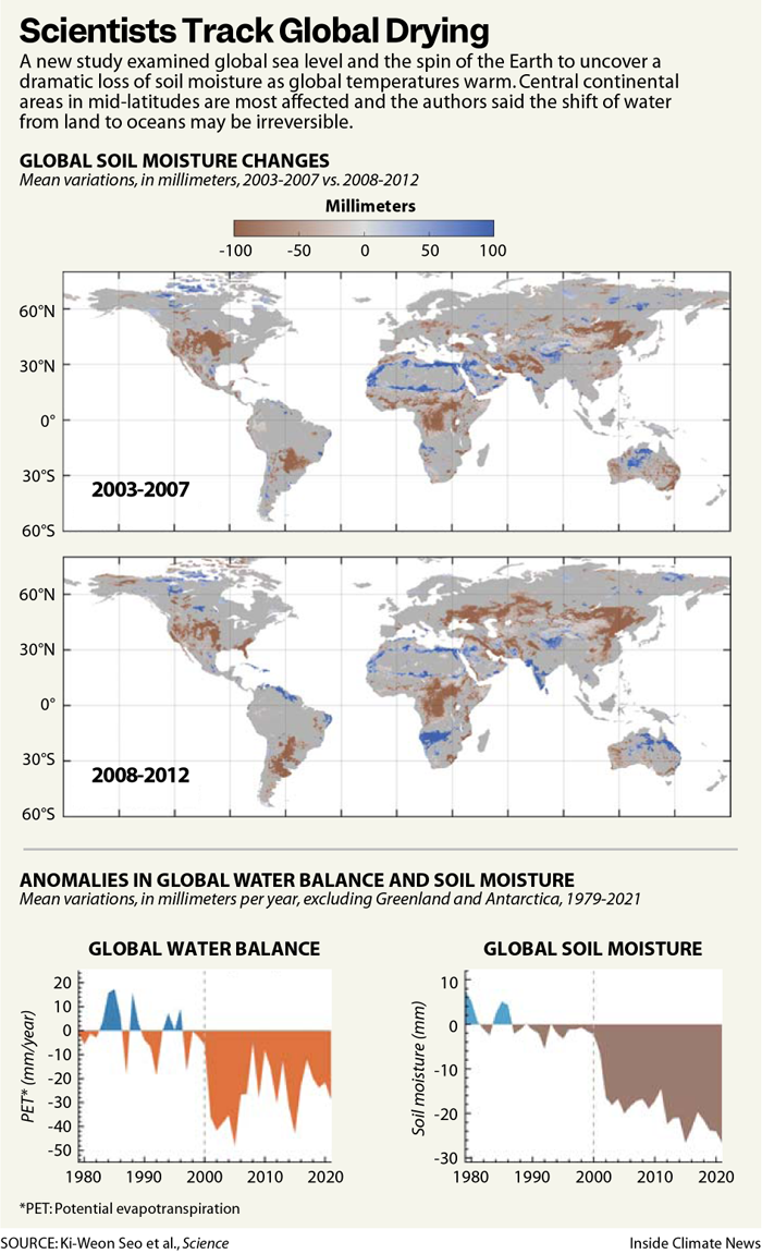
Earth has lost enough soil moisture in the last 40 years to change the planet’s spin and shift the location of the North Pole, according to a new study published today in Science that tracks how human activities have disrupted the global water cycle. The persistent loss of water from land to oceans has dried out huge portions of every continent and may be irreversible, scientists describing the new research said this week.

“Large regions in East and Central Asia, Central Africa, and North and South America show pronounced depletion,” between 2003 and 2007, the authors wrote. When they extended the timeframe to 2021, the depletion of soil moisture grew large enough to cover those areas and also included Europe and the Eastern U.S.

“This study provides robust evidence of an irreversible shift in terrestrial water sources under the present changes in climate,” said Luis Samaniego, a hydrology researcher at the UFZ Helmholtz Centre for Environmental Research in Leipzig, Germany. 

“The continents are drying out over time,” said Samaniego, who was not involved in the new study but wrote a related Perspective article in Science. 

In some regions, there would have to be well above average rainfall for 10 consecutive years to recover from extended periods of drought, he said.

“You can forget it. It’s not going to be like that. This is permanent, at least for our time scale,” he said.

“On a longer timescale, over millions of years…Earth could become as dry as Mars,” he added. “Earth could become a desert without atmosphere, but I don’t think that is where we want to live.”

The new study describes the “magnitude of the changes that we are causing,” he said. “Because at the end, what is creating this change in moisture is this minute molecule of CO2 that we keep pumping and pumping and pumping and pumping, and that’s creating an instability in the atmosphere.”

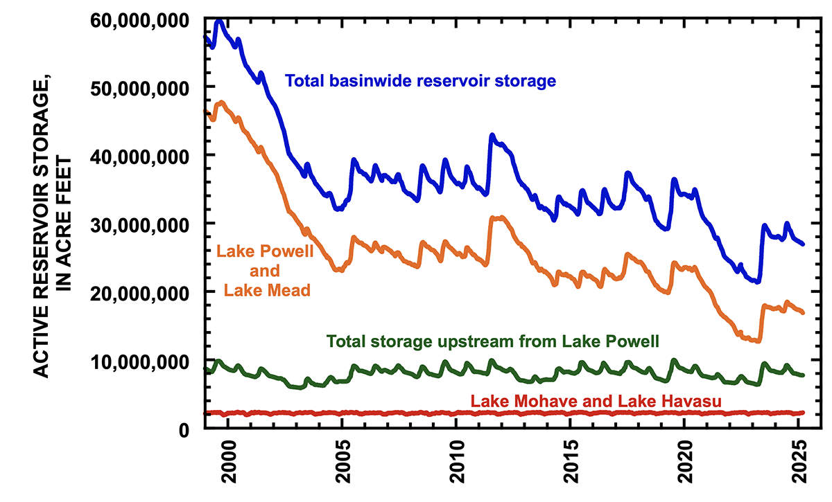
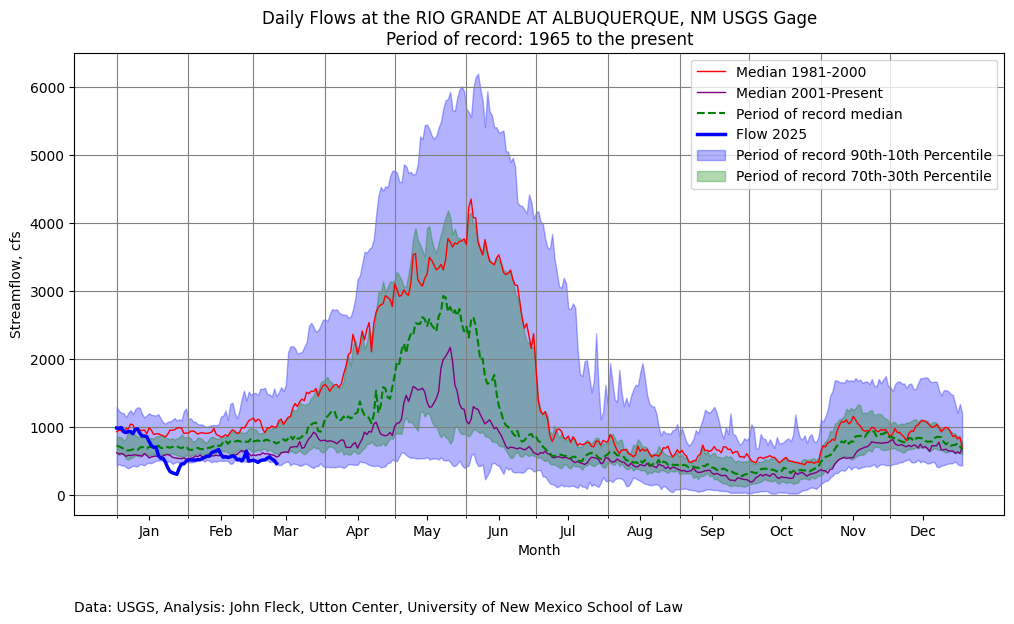
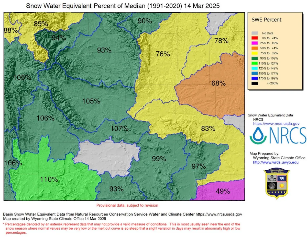
When the researchers combined satellite data about water in soils, sea level measurements and observations of precipitation, they found a “dramatic depletion in soil moisture.” Soils lost about 1,614 gigatons of water between 2000 and 2002—a big downward step in global soil moisture from which there has been no recovery. Instead, the depletion continued, with soils losing an additional 1,009 gigatons of water from 2003 to 2016. In comparison, the Greenland Ice Sheet lost about 900 gigatons of water from melting ice between 2002 and 2006. 

The findings suggest that this decline is primarily driven by shifts in precipitation patterns and increasing evaporative demand due to rising temperatures. As of 2021, soil moisture had made no recovery, the authors noted, adding that they saw little likelihood of recovery under current climate conditions. 

Co-author Dongryeol Ryu, an environmental hydrologist at the University of Melbourne, said that as the researchers examined the data, they saw a step-change in sea level rise in the early 2000s that looked unnatural.

“When something looks too strange or too new, naturally, scientists suspect there were some errors,” he said. “So we tried to replicate that using different measurements.”

When they removed all the possible contributing factors other than soil moisture from their calculations, the big jump in global mean sea level in the early 2000s remained, and matched the loss of soil moisture, with roughly 1 millimeter global mean sea level rise for every 360 gigatons of water lost from land, he said.

At some point, “We may see a drying of lakes and drying streams,” he said, although where the drying trend will lead isn’t clear. “Even if you have sufficient rainfall, they may continue to dry.”

He noted that, globally, funding for ground monitoring has been decreasing and the number of gauge stations declining.

“We need a community effort for that, not just one or two groups, because there are so many different types of monitoring stations,” he said. ”I hope we could put all these isolated data together to see if they are pointing in the same direction.”
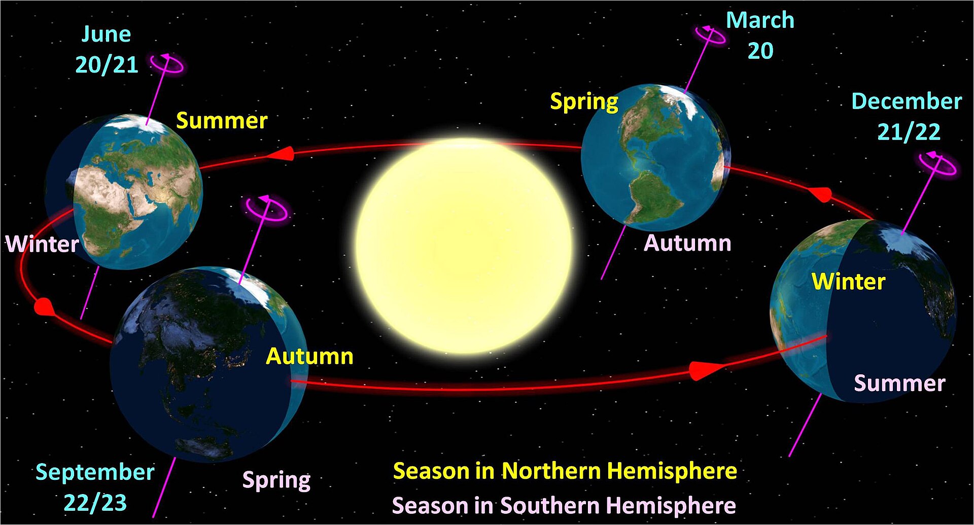
Polar Motion

The redistribution of water can change the way Earth wobbles as it spins on its axis, so the team compared the “polar motion” that shows that teetering to their comprehensive soil moisture database, Ryu said. The changes in the Earth’s spin correlated with the changed distribution of water on the planet, with the wobble behaving as expected with less moisture in soil and more water in the oceans.

The research team included geoscientist Clark Wilson, professor emeritus with the Department of Earth and Planetary Sciences at the University of Texas, who has been studying Earth’s rotation for 50 years, starting with his 1976 dissertation.

“In the early ‘70s, polar motion was just an oddity,” he said, “But now, everybody has a GPS receiver in their cell phone, and the whole GPS system and satellite navigation systems all require very, very accurate knowledge of polar motion.”

That’s led to a big increase in the number of people studying the Earth’s wobble, he said.

In the last 100 years, post-glacial rebound of land and loss of ice masses have shifted the exact location of the rotational axis by about 20 meters, he said. 

Knowing where the exact point of rotation is relative to other fixed points in space is the basis for all modern GPS navigation, including missile guidance systems, but scientists also realized early on that the Earth’s wobble also provided insights about global climate change.

“Global sea level tells you about total water volumes, but it doesn’t say where it came from,” he said. “Polar motion, on the other hand, is sensitive to geographical distribution of mass.”

The Gravity Recovery and Climate Experiment (GRACE) satellite mission launched in 2002 allowed for the observations of how the distribution of mass on the planet was changing, particularly through its ability to monitor terrestrial water storage by measuring changes in gravity.

“It’s a wonderful measurement because in the past, water storage in the soil was done by drilling a well and measuring the level of the water,” he said.

Those isolated measurements didn’t help to define a global water budget that included factors like evaporation and runoff, making it impossible to model planet-wide water cycles, he said. “GRACE has changed all that.” 

Global Drought?

Ryu, the University of Melbourne researcher, said it’s important to go back to the 1980s, when the average global temperature started increasing sharply, to understand the changes they measured in the new study.

Initially, scientists were puzzled that the vapor pressure deficit—a measure of how much moisture is in the air compared to what it could hold at a given temperature—did not immediately increase to match the rising temperatures, he said. 

“But starting in about 2000, the vapor pressure deficit started increasing very steeply, coinciding with our analysis period,” he said. 

Satellite measurements that can track how Earth’s gravitational field changes in space and time show accumulating groundwater depletion from 2003 to 2009 in Australia, the Central Valley of California and the Middle East. A new study building on that data shows there is a global trend of terrestrial moisture loss. Credit: NASA

That coincided with an “unusual” three-year decline of global precipitation from 2000 to 2003, leading to the decline in soil moisture that persisted through at least 2021. The two big declines were in the early 2000s and in 2015 and 2016, the second associated with a strong El Niño, a warm phase of a tropical Pacific Ocean cycle that shifts global rainfall patterns. Another strong El Niño could result in another big step down of global soil moisture, he said.

Regional impacts continue to be concerning, he said, highlighting a highly unusual and ongoing dry period in the Amazon.“If you look at the GRACE data over the Amazon, that’s really scary,” he said.

Drought, in many cases, is a slow-onset impact of global warming, he said.

“Not visible doesn’t mean that it’s not important,” he said. “We are very, very cautious about floods, earthquakes and wildfires, because they happen in the timescale of our life. The impacts are very visible, but drought is a creeping disaster.”

Most conventional drought measurements are based on precipitation and potential evaporative transpiration, which can suggest short-term recovery from drought conditions, but only have limited capability to detect the slow, long-term depletion of soil moisture. But their measurements of terrestrial water around the world found persistent declines, sometimes in steep steps.

“After a shock of rainfall deficits for a year or two, we used to be able to see recovery, but not anymore,” he said. “That is a very serious concern.” 

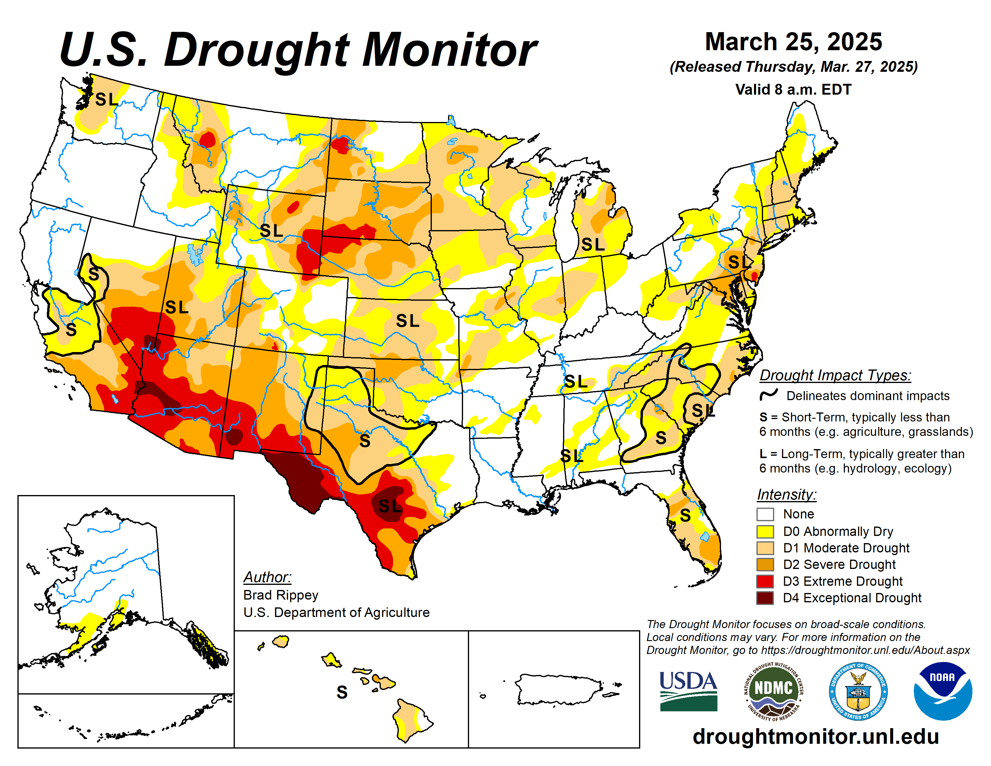
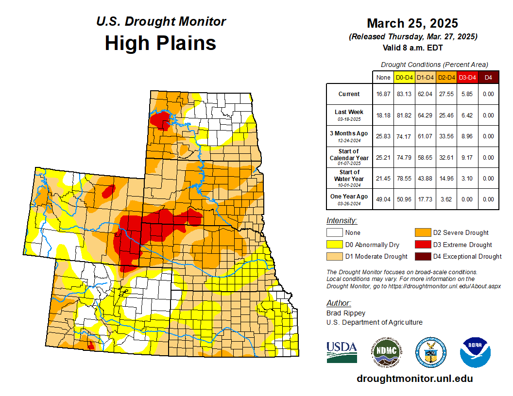
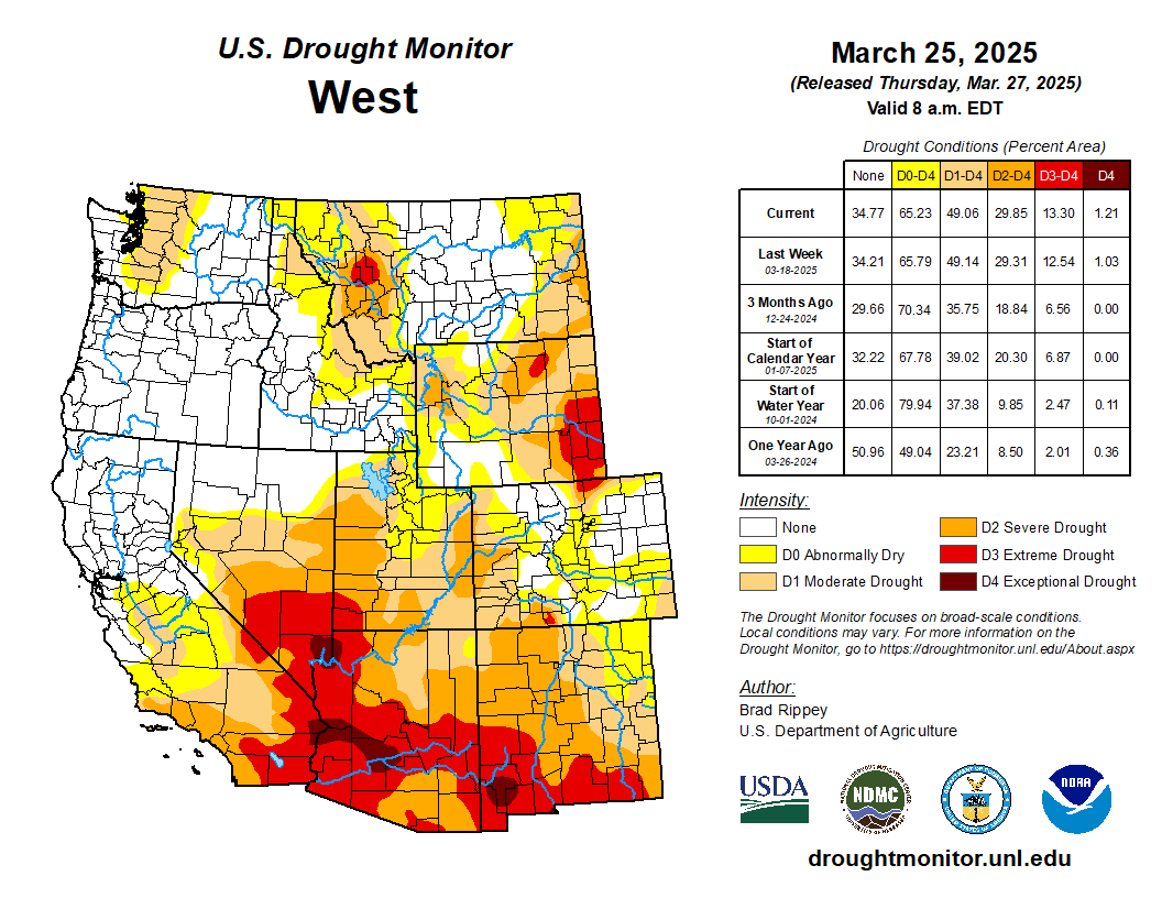
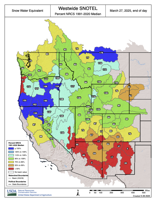
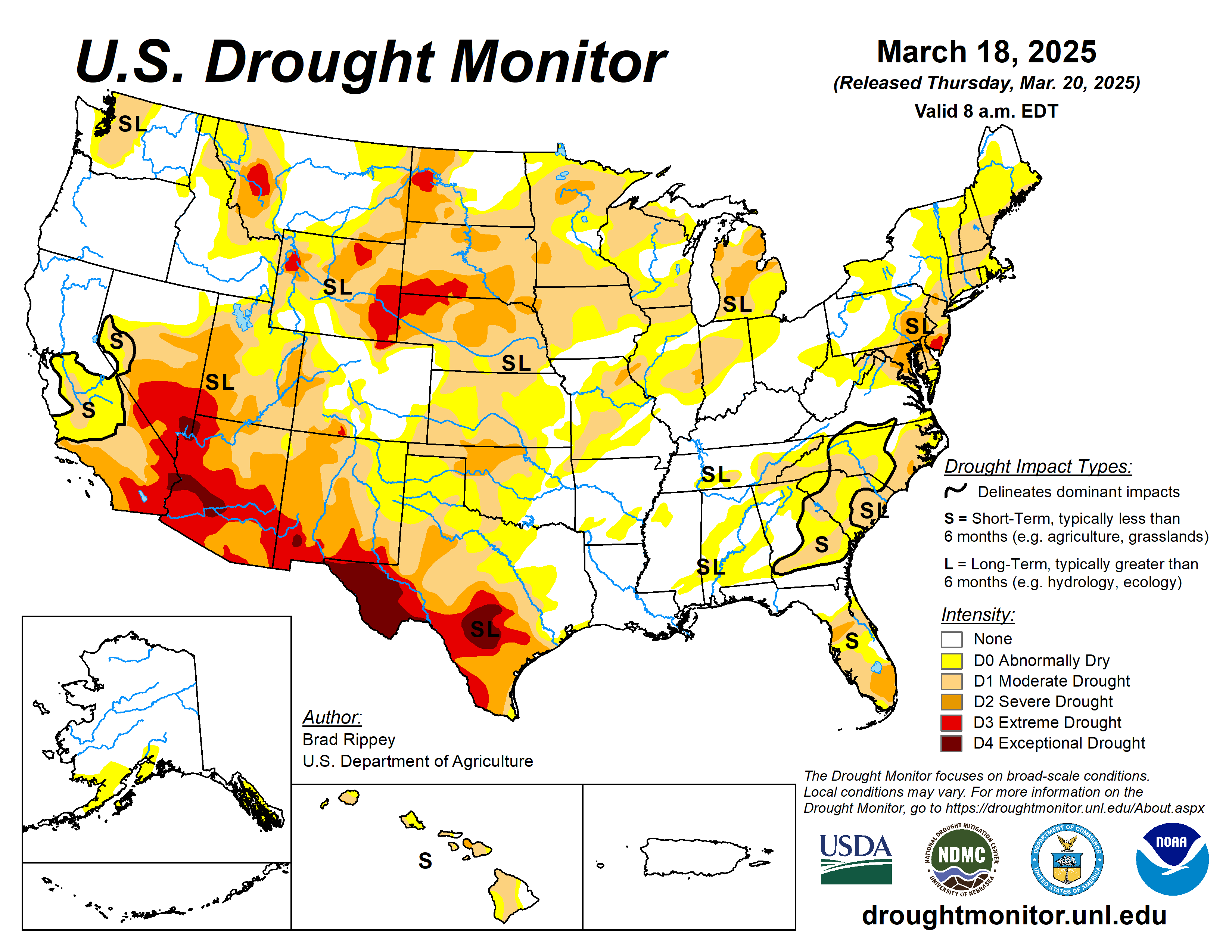
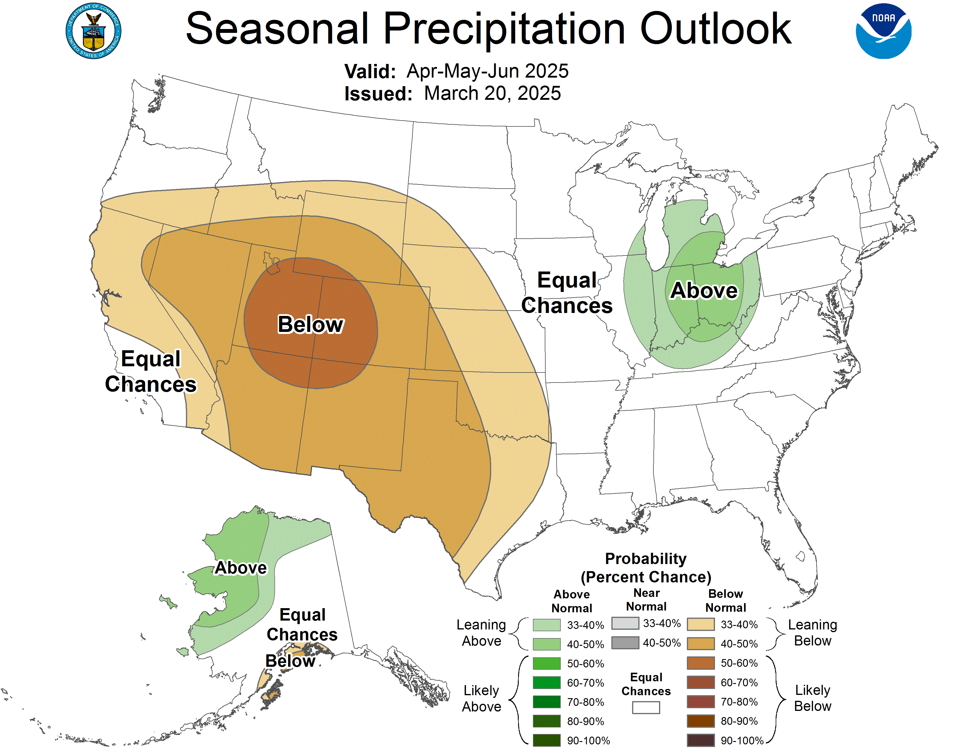
Southwest Hit Especially Hard

The global pattern identified in the new study has been emerging since the GRACE data has become available, said water researcher and co-author Jay Famiglietti, global futures professor at Arizona State University’s School of Sustainability. 

“It’s what the Intergovernmental Panel on Climate Change has been predicting, which is wet areas getting wetter and the tropics and mid-latitudes getting drier,” he said.

The rate of drying in middle latitudes is higher, he noted, because of a positive feedback loop in which people use more groundwater as lands become more arid.

Sensitive satellite-based instruments enable scientists to measure relative variations of Earth’s gravitational field. Data gathered by NASA’s Gravity Recovery and Climate Experiment (GRACE) is used in a new study to show that many continental regions are experiencing long-term aridification. Credit: NASA/JPL/University of Texas Center for Space Research

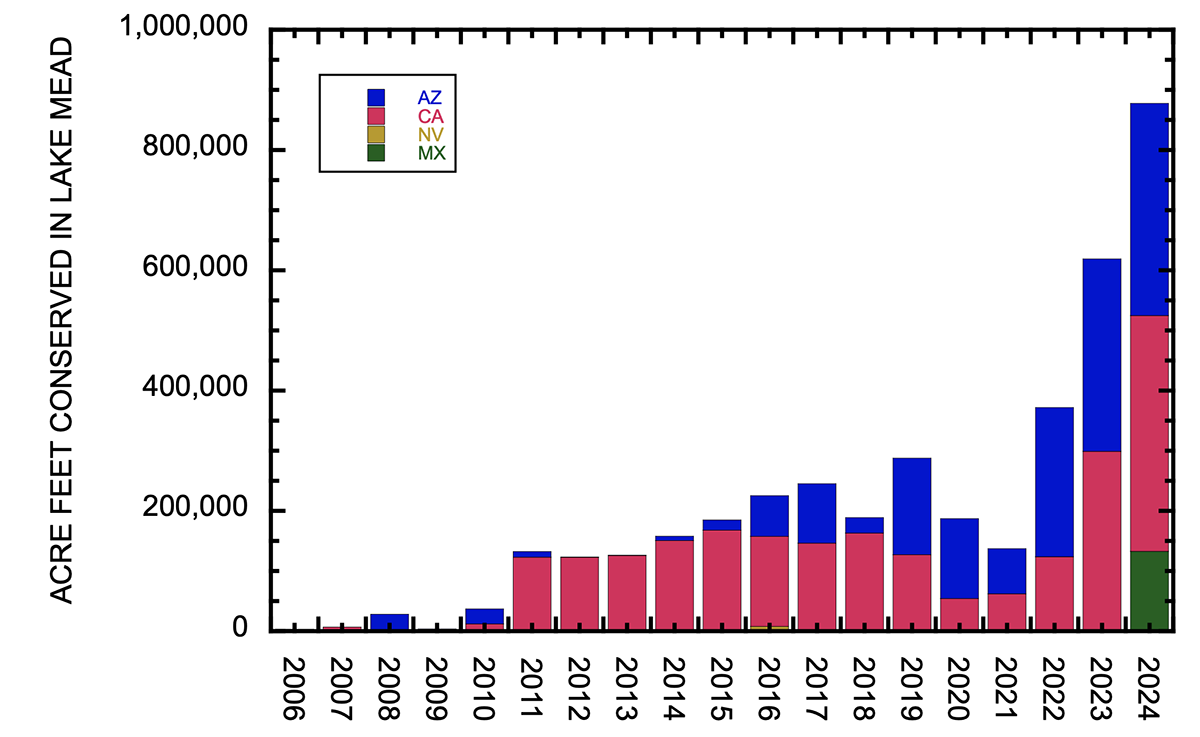
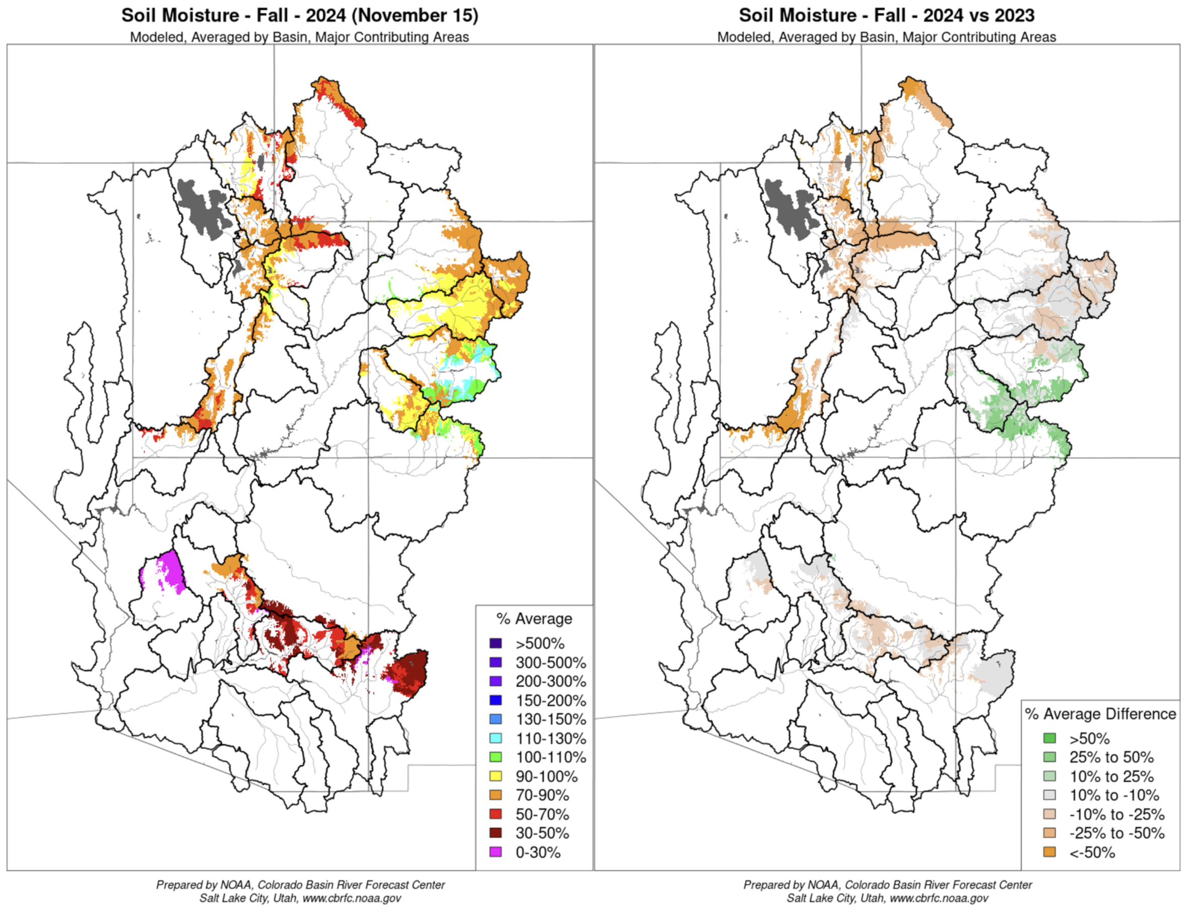
The implications of the research are especially profound in the Southwest, he said, where it shows the Four Corners region has been drying out for 30 or 40 years. 

“That really puts our food security at risk, and it also puts the economy of the Southwest at risk,” he said, noting the growing importance of the water-intensive computer chip and data center industries.

With most rain that falls in the Southwest already evaporating rapidly, and that rate increasing as temperatures climb, staunching the hemorrhaging of groundwater there is critical to the region’s survival.

“With a wet winter, you get a little recovery of groundwater, but then you get a big drop, and then maybe you get another little recovery and another big drop,” he said. “I liken it to a tennis ball bouncing down the stairs.

“It’s pretty much one way. We need to put the brakes on, understanding that we’re not going to get more [water],” he said. 

Bird migration 2025

The first robin that I’ve seen this year here at Coyote Gulch Manor. Migration is ongoing, turn off your outside lights.

Take your children out into these landscapes” — Kevin Fedarko

My friend Joe’s son and the Orr kids at the top of the Crack in the Wall trail to Coyote Gulch with Stevens Arch in the Background. Photo credit: Joe Ruffert

Kevin Fedarko was the keynote speaker at the symposium and he is as inspirational a speaker as you could ask for. It doesn’t hurt that the landscape that he spoke about is the Grand Canyon. He urged the attendees to, “Take your children out into these landscapes so that they can learn to love them.” He is advocating for the protection of the Grand Canyon in particular but really he is advocating for the protection all public lands.

Kevin Fedarko and Coyote Gulch at the Rio Grande State of the Basin Symposium hosted by the Salazar Rio Grande del Norte Center at Adams State University in Alamosa March 29, 2024.

What an inspirational talk from Kevin. I know what he is saying when he speaks about the time after dinner on the trail where the sunset lights up the canyon in different hues and where, he and Pete McBride, his partner on the Grand Canyon through hike, could hear the Colorado River hundreds of feet below them, continuing its work cutting and molding the rocks, because the silence in that landscape is so complete. He and I share the allure of the Colorado Plateau. Kevin was introduced to it through Collin Flectcher’s book The Man Who Walked Through Time, after he received a dog-eared copy from his father. They lived in Pittsburgh in a landscape that was industrialized but the book enabled Kevin to imagine places that were unspoiled.

My introduction to the Colorado Plateau came from an article in Outside magazine that included a panoramic photo of the Escalante River taken from the ledges above the river. Readers in the know can put 2 and 2 together from the name of this blog — Coyote Gulch — my homage to the canyons tributary to Glen Canyon and Lake Foul.

Stevens Arch viewed from Coyote Gulch. Photo via Joe Ruffert

Kevin’s keynote came at the end of the day on March 29th after a jam-packed schedule.

Early in the day Ken Salazar spoke about the future of the San Luis Valley saying, “Where is the sustainability of the valley going to come from.” Without agriculture this place would wither and die.” He is right, American Rivers and other organizations introduced a paper, The Economic Value of Water Resources in the San Luis Valley which was a response to yet another plan to export water out of the valley to the Front Range. (Currently on hold as Renewable Water Resources does not have a willing buyer. Thank you Colorado water law.)

Claire Sheridan informed attendees that their report sought to quantify all the economic benefits from each drop of water in the valley. “When you buy a bottle of water you know exactly what it costs. But what is the value of having the Sandhill cranes come here every year?”

Sandhill Cranes Dancing. Photo by: Arrow Myers courtesy Monte Vista Crane Festival

Russ Schumacher detailed the current state of the climate (snowpack at 63%) and folks from the Division of Water Resources expounded on the current state of aquifer recovery and obligations under the Rio Grande Compact.

The session about the Colorado Airborne Snow Measurement Program was fascinating. Nathan Coombs talked about the combination of SNOTEL, manual snow courses, Lidar, radar, and machine learning used to articulate a more complete picture of snowpack. “You can’t have enough tools in your toolbox,” he said.

Coombs detailed the difficulty of meeting the obligations under the Rio Grande Compact with insufficient knowledge of snowpack and therefore runoff volumes. Inaccurate information can lead to operational decisions that overestimate those volumes and then require severe curtailments in July and August just when farmers are finishing their crops. “When you make an error the correction is what kills you,” he said.

If you are going to learn about agriculture in the valley it is informative to understand the advances in soil health knowledge and the current state of adoption. That was the theme of the session “Building Healthy Soils”. John Rizza’s enthusiasm for the subject was obvious and had me thinking about what I can do for my city landscape.

Amber Pacheco described how the Rio Grande Basin Roundtable and other organizations reach out to as many folks in the valley as possible. Inclusivity is the engine driving collaboration.

Many thanks to Salazar Rio Grande del Norte Center director Paul Formisano for reaching out to me about the symposium. I loved the program. You can scroll through my posts on BlueSky here

Orr kids, Escalante River June 2007

2025 #RioGrande State of the Basin Symposium

I’m in Alamosa to attend the symposium. There is a great program planned for today chock full of information about Colorado’s “South Slope”. Click the link to view the agenda. Of course snowpack will be a large part of the discussion today, as it is every April 1st in Colorado. Also, I’m looking forward to the session featuring a new study from American Rivers with Heather Dutton and Emily Wolf.

Russ Schumacher will be discussing snowpack and precipitation.

layer cakes over the Sangre de Cristos (which could really use some more snow) #cowx

Russ Schumacher (@rschumacher.cloud) 2025-03-29T02:49:25.319Z

Live-posting will be on my BlueSky feed at: https://bsky.app/profile/coyotegulch.bsky.social

President Trump hands public lands to the mining industry: Plus: Using public lands for housing — again — Jonathan P. Thompson (LandDesk.org)

Click the link to read the article on The Land Desk website (Jonathan P. Thompson):

March 25, 2025

⛏️Mining Monitor ⛏️

Satellite image of a portion of the Morenci Mine in Arizona. Source: Google Earth.

Last week, President Trump signed an executive order — his 150th so far this term, by my rough count — invoking the Defense Production Act to expedite mining on federal lands. The wording of the order suggests that the aim is not just to cut through some of the red tape hindering proposed projects, but to incite the industry to mine areas that it may not have been considering previously.

The order has understandably alarmed public lands advocates, but it has also spawned some misconceptions, particularly concerning the 1872 General Mining Law.

Green River Basin oil shale deposits via the Bureau of Land Management

While Trump’s attacks on the nation and public lands have been of unprecedented scope and scale so far, his use of the Cold War-era DPA is not unprecedented or even all that unusual. The Carter administration used it to justify pouring billions of dollars of subsidies into “synfuel” production as part of its quest for “energy independence.” This sparked massive oil shale operations in western Colorado (which crashed spectacularly). And Biden used the Act to encourage mining for so called “green metals,” such as lithium, boron, and manganese. He also streamlined permitting for the proposed Hermosa manganese mine in southern Arizona, and loaned the contested Thacker Pass lithium mine in Nevada $2.6 billion.

But Trump’s order goes much further than Biden’s. He is expanding the list of target minerals to just about everything, including “critical minerals, uranium, copper, potash, gold, and any other element, compound or material as determined by the Chair of the National Energy Dominance Council, such as coal.” While Biden wanted a survey of the nation’s mineral production capacity, and promised to adhere to all existing environmental laws and consult with tribal nations, Trump is ordering his agencies to:

  • Compile a list of all proposed mining projects “in order to expedite the review of those projects in coordination with the National Energy Dominance Council.”
  • Amend or revise land use plans under the Federal Land Policy and Management Act as necessary to “support the intent of this order.”
  • “Identify as many sites as possible that might be suitable for mineral production activities that can be permitted as soon as possible.”
  • Prioritize mineral production activities over other types of activities on federal lands.
  • Provide financing, loans, and investment for new mines, including from a “dedicated critical minerals fund established through the U.S. International Development Finance Corporation.”
  • “New recommendations will be provided to Congress regarding treatment of waste rock, tailings, and mine waste disposal under the Mining Act of 1872.”

Instead of adhering to environmental laws, Trump would simply alter them to support mining. He not only wants to help out proposed projects with regulatory and financial subsidies, but also wants to spur on new projects on “as many sites as possible.” And he is prioritizing mineral extraction over all other activities on federal lands, a blatant violation of the Federal Land Policy Management Act’s multiple-use mandate.

That would mean not only that mining would take precedence over conservation and recreation, but also livestock grazing and other extractive uses. The OHV crowd that’s worried about the BLM closing a few roads to motorized vehicles around Moab might just find themselves ousted from a lot more areas by potash ponds, uranium mines, or lithium operations.

Trump’s recommendations to Congress likely will be to tweak the 1872 Mining Law to ensure that mining companies can store waste on public land mining claims that aren’t valid, meaning that they have not proven that the parcels contain valuable minerals. This was actually the norm for decades until 2022, when a federal judge ruled that the proposed Rosemont copper mine in Arizona could not store its tailings and waste rock on public land. That ruling was followed by a similar one in 2023, leading mining state politicians from both parties to try to restore the pre-Rosemont Decision rules.

It’s around the General Mining Law that misconceptions have arisen. The folks at More Than Just Parks say the new order “doesn’t create a new legal framework. It exhumes an old one — a fossil from the 19th century … It’s the Mining Act of 1872, back from the dead, and now wearing body armor.” Which is a nice way to put it, but the Mining Act never died, so this order can’t revive it.

The other misconception appeared in Lands Lost, another great Substack focusing on public lands, which wrote: “… there are no meaningful environmental safeguards in place because public land mining is a free-for-all governed only by an 1872 law that’s never been modernized.”

It’s true that the 1872 Mining Law is inadequate, allows mining companies or individuals to stake a claim to any public land without public input or environmental review, conduct exploratory work with a minimum of review, and pay no royalties on hardrock minerals they extract. However, the federal agencies do have additional regulations governing mining. Before a company can do any actual mining, it must get an operating permit from the Bureau of Land Management, U.S. Forest Service, or Department of Energy (depending on the land’s jurisdiction), which includes an environmental review (either an EA or a more extensive EIS, depending on the scope of the project). A mine may also need a Clean Water Act permit for any water discharges, including draining adits, and many states require additional permits as well.

By ordering the agencies to alter the FLPMA land-use plans to accommodate mining, Trump is essentially doing away with these additional safeguards, which really is scary. That would take us back to a time when the 1872 Mining Law was the only federal regulatory framework, which would give mining companies a free rein to trash public lands. However, Trump can’t do much about state requirements, except to try to bully them out of existence. [ed. emphasis mine]

The order applies only to federal lands, so mining projects that are on patented mining claims — which are entirely on private — would not be affected (although they might be eligible for the government handouts). 

Proposed projects this fast-tracking could affect include:

  • Resolution Copper’s proposed massive copper mine at Chi’chil Biłdagoteel, aka Oak Flat, in central Arizona.
  • Copper World Complex née Rosemont Mine in the Santa Rita Mountains south of Tucson, Arizona. After a judge kiboshed Canada-based Hudbay’s plan to dump mine waste on U.S. Forest Service land, the firm decided to base the initial phase on patented, i.e. private, mining claims and later expand to public lands.
  • South32’s proposed Hermosa Mine in the Patagonia Mountains of southern Arizona. Biden already fast-tracked permitting for this battery-grade manganese mine, but Trump’s order could speed it along even more.
  • Energy Fuels’ Roca Honda uranium mine and Laramide Resources’ La Jara Mesa uranium project, both on Forest Service land near Grants, New Mexico.
  • Anson/A1’s proposed lithium extraction projects and American Potash’s lithium and potash projects on BLM land east and north of Moab and south of Green River, Utah.
  • Lithium, copper, and uranium projects on BLM land in the Lisbon Valley in southeastern Utah.
  • Numerous proposed uranium mining projects on Energy Department leases and BLM land in the Uravan Mineral Belt in western Colorado.
  • Atomic Minerals’ uranium prospects on Harts Point, just outside the boundaries of Bears Ears National Monument.
  • Metallic Minerals is only doing exploratory drilling on its mining claims in the La Plata Mountains of southwestern Colorado, and have yet to make any mining plans public, so it’s not clear whether Trump’s order would affect this contested project.
  • Learn more about these and other projects with the Land Desk’s Mining Monitor Map.

Those links up ^^ there? A lot of them are to paywalled Land Desk archives. Break down the paywall and support oligarch-free journalism by becoming a paid subscriber now.


Satellite image of Phoenix-area sprawl and adjacent BLM land. Source: Google Earth.
🌵 Public Lands 🌲

Also last week, in a short-on-details Wall Street Journal opinion piece, Interior Secretary Doug Burgum and Housing and Urban Development Secretary Scott Turner unveiled a plan to transfer or lease “underused” public lands to states or localities for affordable housing. An Interior official then told Bloomberg Law’s Bobby Magill that the Bureau of Land Management is considering selling about 400,000 acres of federal land within 10 miles of cities and towns with more than 5,000 people for housing development.

This isn’t surprising: Republicans and Democrats have both been itching to grab some public land for housing for a while. And the stated intent, to add affordable housing to increasingly unaffordable public lands-gateway communities, is noble.

And yet, the plan — as scant in particulars as it is — is still riddled with problems.

Burgum has made it clear that he distinguishes between “special” and “our most beautiful” public lands, i.e. those that are in national parks or national monuments, and the remaining “underused,” “inhospitable or unoccupied” lands. The lands on the urban fringes he intends to take out of the American public’s hands belong to the latter category, apparently.

But those same lands are valuable, especially to the nearby communities. They provide an easy-to-access refuge — for humans and wildlife — from the urban din, as well as recreational opportunities. In fact, the close proximity of these public lands makes the communities more desirable and therefore more expensive: think Animas Mountain in Durango, the Slickrock Trail in Moab, Jumbo Mountain in Paonia, the Lunch Loop trails in Grand Junction, the Buckeye Hills near Phoenix, or the Juniper Woodlands trails outside Bend. Now imagine them covered in houses.

Because BLM lands are almost always outside the urban boundaries, developing them will lead directly to sprawl and all of its impacts, including more traffic and associated pollution and safety issues.

So far, the Interior Department hasn’t given any indication that it would require the land to be used for affordable housing. And, as Center for Western Priorities points out in a statement on the plan, the administration hardly seems interested in fixing the housing crisis, given that it is planning to eviscerate HUD and has frozen some $60 million in funding for affordable housing. 

Which leads me to think they are using Sen. Mike Lee’s stalled HOUSES Act, which also calls for putting houses on “underutilized” federal land, as a model. But that legislation has no affordability restrictions and its density requirement — a mere four houses per acre — is just more sprawl.

That’s because Lee and company are going with the supply side theory, which posits that simply building more houses will lower costs enough to make them affordable. While this theory does hold in certain cases, it does not apply to most Western public lands-gateway, amenities communities, where seemingly unlimited demand is always bound to outpace supply. And that means this plan is just another scheme to take public lands out of Americans’ hands and give them to the private sector.

On the housing supply-side theory JONATHAN P. THOMPSON SEPTEMBER 19, 2023: https://www.landdesk.org/p/on-the-housing-supply-side-theory


📸 Parting Shot 🎞️

LOVE windmill. Near Leupp, Arizona. Jonathan P. Thompson photo.

March snowfall in Northwest #Colorado shifts region away from possible #drought development in spring — Steamboat Pilot & Today #snowpack

Click the link to read the article on the Steamboat Pilot & Today website (Ali Longwell). Here’s an excerpt:

March 24, 2025

Snowfall in March has helped decrease the likelihood of drought developing this spring in Colorado’s northwest mountains. However, a warm and dry spring could still change the tide heading into summer.  The National Weather Service, a division of the National Oceanic and Atmospheric Administration, released its latest seasonal drought outlook on Thursday, March 20. It showed that drought conditions are unlikely to develop in most of northwest Colorado through June…Brad Pugh, a forecaster with the National Oceanic and Atmospheric Administration’s climate prediction center, said these outlooks predominantly take into account the current conditions, climatology temperature and precipitation outlooks over the next three months. 

“In northwestern Colorado at this time of year, you know going into the springtime, mountain snowpack is a critical factor,” Pugh said.

As of March 18, much of northwest Colorado was in line with, or just above, normal snowpack. This has continued to improve in the state’s north-central mountains since January. According to OpenSnow, as of Monday the snow totals and percentage of normal on the season so far were as follows:  

  • Winter Park – 315 inches (117%) 
  • Copper Mountain Resort – 303 inches (113%) 
  • Vail Mountain – 292 inches (101%) 
  • Breckenridge Ski Resort – 284 inches (107%) 
  • Steamboat Resort – 279 inches (108%) 
  • Aspen Highlands — 267 inches (88%) 
  • Loveland Ski Area – 261 inches (108%)
  • Snowmass – 243 inches (83%) 
  • Keystone Resort – 239 inches (107%) 
  • Beaver Creek – 227 inches (108%)
  • Arapahoe Basin Ski Area – 225 inches (112%)
  • Aspen Mountain – 210 inches (92%) 
  • Ski Cooper – 206 inches (106%)
  • Buttermilk – 147 inches (89%)
Colorado Drought Monitor map March 25, 2025.

The latest U.S. Drought Monitor for Colorado reported no drought in many of the northwest counties including Summit, Grand, Routt and Jackson counties as well as the eastern reaches of Eagle and Moffat counties. Heading west, the monitor shows abnormally dry conditions in Pitkin County and the eastern portions of Garfield and Rio Blanco counties. Conditions continue to get progressively drier the further west toward the border.

Water powers the heart of life in the #SanLuisValley: New study details the economic benefits of key sectors and services that depend on water — Heather Dutton and Emily Wolf (AlamosaCitizen.com) #ActOnClimate

A view of one of the Valley’s major agriculture resources, cattle. Credit: Owen Woods

Click the link to read the article on the Alamosa Citizen website (Heather Dutton and Emily Wolf):

March 27, 2025

Here in the San Luis Valley, water is deeply connected to our way of life. The Rio Grande, its tributaries and connected groundwater support local heritage, agriculture, recreation and the natural environment. Like all of the region’s streams and rivers, the Rio Grande is critical to the livelihood and economies of the communities of the SLV and is a growing recreational and economic asset to communities outside of the Valley as well.

Photo credit: Sinjin Eberle/American Rivers

To help illustrate the critical value water plays across all sectors in the Valley, American Rivers and One Water Econ released a new study this week, The Economic Value of Water Resources in Colorado’s San Luis Valley, which presents the economic benefits of key sectors and services that depend on water in the Valley. The analysis looks at irrigated agriculture, municipal and industrial uses, tourism and recreation, and environmental values like wildlife habitat.

While we all know and understand the intrinsic value of water in the Valley, economic data will further elevate not only the social importance of water, but also the economic contributions the Rio Grande and Conejos River, other streams, and connected groundwater provide to the San Luis Valley. Our community can use this economic data to tell the story of ongoing collaborative water management projects, help fight future threats, including groundwater export schemes, and make the case for multi-benefit river restoration efforts that are a win-win-win for agriculture, communities, and the environment.

San Luis People’s Ditch March 17, 2018. Photo credit: Greg Hobbs

Irrigated agriculture, a key economic driver in the SLV, is reliant on the surface water flowing through the Valley along with the vast number of groundwater wells and is deeply connected to the history of the Valley. The study found that crops supported by surface and groundwater make up 39 percent of Colorado’s total agricultural output, despite the population of the Valley being less than 1 percent of Colorado’s population. Additionally, irrigated agriculture was found to contribute more than $480 million annually in economic output. For every $1 that is spent on local inputs for agriculture production, an additional $1.56 is generated in the regional economy. Potatoes and vegetables are the largest economic generators in the agricultural space, with an annual economic output of $184 million. Not only does irrigated agriculture provide critical economic benefits, but the irrigated fields and wet meadows also support critical migratory bird habitat.

Sandhill cranes stop and gather in a field near the Monte Vista National Wildlife Refuge during their yearly trek.

Recreation, a growing economic sector for the Valley, is heavily reliant on water flowing from the surrounding mountains into the Valley and provides significant economic value. The Great Sand Dunes National Park and Preserve attracts national and international travelers, as do the world-class birding and wildlife viewing opportunities at the nine state and national wildlife refuges that are made up of wetland, riparian, and open water ecosystems, and support numerous species of resident and migratory birds, including sandhill cranes. Additionally, the Rio Grande and Conejos River draw many visitors for both whitewater boating and world class fishing. The recent economic analysis found water-related recreation provides $213.7 million in benefits annually in the San Luis Valley, and for every $1 spent on recreation, $1.91 is generated through ripple effects within the local economy. The Valley’s riverside lands, wetlands, and wet meadows are a critical part of the natural infrastructure supporting recreation and many species of wildlife. The analysis found that water-related habitat in the Valley is valued at more than $49 million annually and the annual Crane Festival generates $4 million in direct revenue from visitor spending.

Many other industries beyond recreation and agriculture also rely on water – local breweries, distilleries, bakeries, greenhouses, hospitals, and hotels among others – all rely on water. These “water-dependent” industries (WDIs) generally rely on the services of water utilities to support and grow their businesses. Water-dependent industries in the Valley support nearly $1.3 billion annually in total economic output. Water is undeniably a critical resource for the Valley, providing not only economic benefits but other ecosystem services, and intrinsic and cultural values. The economic data from this new analysis provides San Luis Valley communities with information to help protect the Valley from export schemes, further support water projects that conserve the Valley’s precious resources, and illustrate to those outside the Valley why water is so critical to the livelihoods of every person in the SLV.

Partners involved in the creation of the study from American Rivers, One Water Econ, and the San Luis Valley Water Conservancy District will present information about the study at the Rio Grande State of the Basin Symposium at Adams State University on March 29. The event is open to the public and all are encouraged to attend. The analysis is also available on American River’s website at www.americanrivers.org/SLVEconomicReport.

#Drought news March 28, 2025: Warm weather prevailed in many areas east of the Rockies, significant increases of all drought categories were introduced in #NewMexico

Click on a thumbnail graphic to view a gallery of drought data from the US Drought Monitor website.

Click the link to go to the US Drought Monitor website. Here’s an excerpt:

This Week’s Drought Summary

On March 18—for the second time in 5 days—a ferocious dust storm across the southern High Plains and neighboring regions led to sharp visibility reductions and increasingly stressful conditions for rangeland, pastures, and winter grains. The dust, lofted by high winds, was drawn into a storm system crossing the central Plains and upper Midwest, leading to widespread reports of “dirty” rain and snow. On March 19-20, significant accumulations of wind-driven snow occurred from parts of Kansas and Nebraska into northern Michigan, while locally severe thunderstorms erupted across the Midwest. More than a dozen tornadoes were spotted on March 19 across Illinois and Indiana. Farther east, however, parts of the Carolinas experienced a rash of spring wildfires, with the Black Cove and Deep Woods Fires near Saluda, North Carolina, collectively charring some 6,000 acres of vegetation and destroying at least 20 structures. Some of the fuel for fires in the Carolinas was provided by trees downed by Hurricane Helene about 6 months ago. Elsewhere, dry weather dominated the southern Plains and the Southwest, while late-season precipitation fell in northern and central California and the Northwest. According to the California Department of Water Resources, the average water equivalency of the high-elevation Sierra Nevada snowpack climbed nearly to 25 inches, essentially ensuring a normal seasonal accumulation. For the second week in a row, near- or below-normal temperatures dominated the West, although warmer weather arrived late in the drought-monitoring period. Conversely, warm weather prevailed in many areas east of the Rockies, with consistently chilly conditions limited to portions of the nation’s northern tier…

High Plains

Major storm systems continued to “undercut” the Dakotas and portions of neighboring states. Notably, severe drought (D2) was broadly expanded in South Dakota, where season-to-date snowfall totals were broadly at least 1 to 2 feet below average. With the northern Plains’ drought occurring at multiple time scales, current impacts include poor conditions for rangeland, pastures, and winter wheat. In contrast, late-season storminess across the northern Intermountain West, including much of northern and western Wyoming, led to improved mountain snowpack, more favorable spring and summer runoff prospects, and reductions in drought coverage and intensity…

Colorado Drought Monitor one week change map ending March 25, 2025.

West

Occasional precipitation continued to fall across roughly the northern half of the region, further improving high-elevation snowpack, as well as spring and summer runoff prospects. Drought improvements of up to one category were introduced from the northern Great Basin to the northern Rockies. Meanwhile, dry weather returned across the Southwest, following some late-season precipitation that was heaviest in parts of southern California but did not reach the southern Rockies. In fact, significant increases of all drought categories were introduced in New Mexico, parts of which have been affected by the same windy, dusty weather that has been plaguing the southern Plains…

South

Drought-related impacts further spread and intensified across parts of Texas and Oklahoma, amid March winds, dust, and dryness. In fact, two previously separate areas of drought were connected across Texas and Oklahoma. Meanwhile, little rain has fallen since mid-February across Arkansas and portions of neighboring states. While the short-term dryness has been favorable for spring fieldwork, rain will soon be needed across the mid-South for pastures, fall-sown small grains, and recently planted summer crops. By March 23, nearly one-half (46%) of the intended rice acreage had been planted in Louisiana, along with 36% in Texas. In Arkansas, 10% of the corn and 2% of the rice had been planted by March 23, while 7% of the winter wheat had headed. Pastures in Arkansas—rated 27% very poor to poor on March 23—were just starting to exhibit some stress from short-term dryness. On that date, rangeland and pastures in Texas were in much worse shape (71% very poor to poor), reflecting drought at multiple time scales and the impact of recent blowing dust…

Looking Ahead

Drought-easing rain across southern Texas will gradually shift eastward along the Gulf Coast. Five-day rainfall totals could reach 2 to 8 inches or more across the western half of the Gulf Coast region, with higher totals leading to flooding in southern and coastal Texas. Meanwhile, active weather will also prevail in the vicinity of a nearly stationary front draped across the northern United States. The front will separate cold air to the north from warmth farther south, with accumulating snow expected during the weekend from parts of the northern Plains eastward into northern New England. Meanwhile, Midwestern 5-day rainfall could total 1 to 2 inches, accomdpanied at times by locally severe thunderstorms. Elsewhere, persistent low pressure near the northern Pacific Coast will maintain showery, unsettled conditions from the Northwest to the northern Rockies, while mostly dry weather will persist in the Southwest, despite a cooling trend.

The NWS 6- to 10-day outlook for April 1-5 calls for above-normal precipitation nearly nationwide, with northern and central California and the western Great Basin having the greatest likelihood of experiencing wet conditions.  Elevated odds of near- or below-normal precipitation should be limited to southern Texas.  Meanwhile, warmer-than-normal weather from the southern half of the Plains to the middle and southern Atlantic Coast should contrast with below-normal temperatures in the Far West and across the nation’s northern tier.

US Drought Monitor one week change map ending March 25, 2025.

#Snowpack news March 28, 2025 — Shannon Mullane (Fresh Water News)

Blanca Wetlands, Colorado BLM-managed ACEC Blanca Wetlands is a network of lakes, ponds, marshes and wet meadows designated for its recreation and wetland values. The BLM Colorado and its partners have made strides in preserving, restoring and managing the area to provide rich and diverse habitats for wildlife and the public. To visit or get more information, see: http://www.blm.gov/co/st/en/fo/slvfo/blanca_wetlands.html. By Bureau of Land Management – Blanca Wetlands Area of Critical Environmental Concern, Colorado, Public Domain, https://commons.wikimedia.org/w/index.php?curid=42089248

Click the link to read the article on the Water Education Colorado website (Shannon Mullane):

March 27, 2025

The pressure is on: Colorado’s average snowpack statewide masks worrisome water conditions in the south, where water providers are banking on more storms to boost water supplies before snowmelt begins in April.

Much of Colorado’s annual water supply is stored in its winter snowpack, which builds up until early April when it melts and flows into soils, streams and reservoirs. Statewide, Colorado is headed toward that April 8 peak with 92% of its normal snowpack for this time of year. But conditions vary widely from north to south and within individual river basins, leaving some water experts concerned about drought, wildfires and reservoir levels, officials said during a Water Conditions Monitoring Committee meeting Tuesday.

One of those experts is Pat McDermott, who is based in the Upper Rio Grande River Basin in south-central Colorado, where the snowpack is 69% of the norm from 1991 to 2020.

“We need to keep having snow. This has been a dismal year for snowpack accumulation,” McDermott, a staff engineer for the Colorado Division of Water Resources, said Tuesday. “We had a whole month and a half — from Dec. 1 to Jan. 15 — when it hardly snowed a speck.”

In the northern half of the state, the snowpack is normal, according to the Natural Resources Conservation Service.

The Colorado Headwaters Basin, where the Colorado River begins; the Yampa-White-Little Snake combined basin, which supplies Western Slope communities in the northwestern corner of the state; and the South Platte Basin, which feeds rivers on the Front Range, are all in good condition.

The Laramie and North Platte combined basin was the only region with a higher-than-average snowpack, measuring about 103% of the median compared to the 30-year period as of Tuesday. There is a storm in the forecast this week — both small positive notes for an area dealing with persistent drought conditions after a dry summer in 2024.

The snowpack in these regions typically peaks between April 8 and April 26.

With these conditions heading into spring runoff, officials have an eye out for flooding. Flood risk from snow runoff might be suppressed in areas where the snowpack is lower than average, said Kevin Houck, chief of watershed and flood protection at the Colorado Water Conservation Board, which hosts the monthly water conditions meeting.

Westwide SNOTEL basin-filled map March 27, 2025 via the NRCS.

Some of these northern basins, like the Yampa-White-Little Snake basin, are heading into the summer with little drought and average reservoir levels in addition to the normal snowpack.

In southern parts of the state, it’s the opposite.

Experts are scouring the data. They’re gauging moisture in the soil, pre-runoff reservoir conditions and weather forecasts for the next three months.

Their goal is to assess whether regions are being dealt a bad hand.

A poor snowpack can mean less water flowing into rivers and streams. Some of that subpar runoff can get sucked up by dry soils. That leaves even less water flowing into reservoirs that are already low. Sparse storms in the forecast, and warm or dry conditions can just make matters worse.

These compounding factors elevate concerns about wildfire risk and raise the odds that farmers will have to reduce their crop output because they won’t have enough irrigation water.

That’s what happening in southern Colorado with more warm and dry weather on the horizon.

“That is not the kind of outlook that we like to see at this point either,” said Russ Schumacher, the state climatologist, in a presentation during Tuesday’s water conditions meeting.

Spotlight on the Upper Rio Grande

Down in the south-central region of the state, McDermott is worried.

At the summit of Wolf Creek Pass, the snowpack is 66% of normal. But down the pass toward Pagosa Springs and the rest of the San Juan River Basin, the snowpack is 45% of average.

“It’s worse this year at Wolf Creek than it was on the same date in 2018, so we’re using 2018 as a potential forecast point here in the Upper Rio Grande Basin this year,” McDermott said. “Of course, 2018 was a terrible year.”

That year, the snowpack peaked March 30 with 6.9 inches of liquid water in the snow. It normally peaks on April 3 with 14.4 inches, according to federal data. Runoff plummeted and ended a month early.

This year, the basin had 7.9 inches of liquid water in the snow as of Tuesday.

In the Upper Rio Grande River Basin, there are two positives to consider: The region had good precipitation heading into the winter, which locked more moisture into the frozen soils, and some of the smaller basins have a better snowpack than others.

On the east side of the San Luis Valley, the snowpack in the Sangre de Cristo mountains varies from 30% to 96% of normal in basins that are mere miles from each other. The snowpack near Great Sand Dunes National Park is at 6%.

“It looks like it’s going to be below normal over there on the Sangre de Cristos, but depending on which little basin you’re in, you may have a little better year than others,” McDermott said.

March, normally the region’s snowiest month, has not served up enough snow to make up for the dry winter. It’ll need more snow just to hold onto that before spring runoff starts, he said. The region’s snowpack typically reaches its peak accumulation April 3.

Climate models indicate less than the normal amount of precipitation across southern Colorado for the next week.

McDermott predicted that it will be one of the top 10 worst runoff seasons basinwide since 1900, during the water meeting Tuesday. The basin is heading into a subpar spring runoff with reservoirs that are already low, holding just 20% to 60% of their full capacity.

Sanchez Reservoir stored about 5,000 acre-feet of its 100,000-acre-foot capacity as of Tuesday. One acre-foot of water equals about 325,850 gallons of water and can supply roughly two to four households for one year.

“We’re a little hamstrung,” McDermott said. “We’re running what appears to be a dry year.”

The future outlook does not offer much relief to the basin or other regions of southern Colorado.

The two-week forecast shows higher temperatures across the state, and less-than-average precipitation in the southeastern region, Schumacher said.

Colorado Drought Monitor March 25, 2025.

Drought conditions are already creeping into the Western Slope, although drought conditions have improved along the Front Range, north-central Colorado and the Eastern Plains. By June, the wildfire risk is expected to be above normal for the southwestern corner of the state, Schumacher said.

“The news is probably tilted towards the bad side in terms of drought,” he said.

More by Shannon Mullane

Despite Staff and Budget Cuts, NOAA Issues Critical Drought Warnings in Its Spring #Climate Outlook — Bob Berwyn (InsideClimateNews.org)

The Colorado River at Lees Ferry, the dividing line between the Upper Basin and Lower Basin states. Jonathan P. Thompson photo.

Click the link to read the article on the Inside Climate News website (Bob Berwyn):

March 24, 2025

The embattled agency continues to disseminate crucial updates in a hostile political environment, while scientists warn that cutting climate intelligence is folly at a time of escalating climate extremes.

The National Oceanic and Atmospheric Administration, although battered by Trump administration attempts to impose massive staff and budget cuts on the agency, nevertheless continues to publish critical climate information, including some dire drought warnings in the spring outlook published March 20 by NOAA’s Climate Prediction Center.

The outlook calls for continued dry conditions in the Southwest, where global warming is a key driver of a long-term megadrought that is already disrupting water supplies to cities and nationally important agricultural zones.

US Drought Monitor map March 18, 2025.

About 40 percent of the contiguous 48 states are currently in some stage of drought or abnormally dry conditions, and those are expected to persist in the Rocky Mountains and the Southwest and Southern Plains, according to the March 20 bulletin. 

In the past two weeks, water officials in the West warned that, despite near-average snowpack in some parts of the Colorado River’s mountain watershed, the river’s flows are expected to drop below normal, exacerbating tensions between water users in the region. In New Mexico, water experts said the Rio Grande is likely to dry up completely in Albuquerque as early as June. A 2024 study explained how global warming drives a cycle that leads to measured flows in Western rivers and streams being consistently lower than predictions based solely on snowpack measurements.

Other recent research suggests drought risks in North America have been widely underestimated by major climate reports, as rising global temperatures bake the moisture out of plants and out of the soil itself. Annual cycles of decreasing winter snow followed by extreme heat are pushing “a global transition to flash droughts under climate change,” a 2023 study concluded.

“Watch out,” said Dave Breshears. a University of Arizona climate and tree researcher and regents professor emeritus. “We have a triple whammy, with areas already in drought headed into more drought and associated with warmer than usual temperatures. Hotter droughts make wildfires more likely, more extreme and bigger.”

Breshears has co-authored research showing “what conditions cause lots of trees to die, and we know if hotter droughts continue for a longer period, we could have more die-off of trees and other plants,” he said. “This becomes a fuel source for future wildfires.”

NOAA needs more, not fewer, resources to adequately identify such rapidly intensifying climate threats that put people, food supplies and ecosystems at risk, he said.

“The large-scale coordinated data that our premier federal agencies bring together to create these products are so important to so many people on a day-to-day basis,” he said. “Many of them are not aware of the ultimate source of this information.” NOAA’s widespread coordination of data for important reports like the seasonal outlooks is “something we won’t be able to reproduce if they aren’t there for us,” he added.

Citing its aims to reduce costs and make government more efficient, the Trump administration tried to fire hundreds of NOAA employees in February. On March 13, a federal judge in Maryland issued a temporary restraining order, and the U.S. Department of Commerce then said it would reinstate employees—but put them on administrative leave pending further judicial review.

The continuing budget resolution passed by Congress March 14 reduces NOAA’s operations, research and facilities budget by 11 percent from the previous year, and according to congressional sources, it stripped away some of Congress’s budgetary oversight privileges. That could enable the Trump administration to zero out budgets for programs and offices within NOAA and use its ocean and climate budgets as a slush fund.

In the past week, the National Weather Service, a branch of NOAA, said it was cutting the number of weather balloon launches at several locations, which could compromise the agency’s ability to provide timely and accurate drought warnings, as well as forecasts for other dangerous extremes.

In early February, NOAA also removed the latest edition of a climate literacy guide from its website. The guide was designed specifically to help educate the public about climate science and efforts to halt global warming and adapt to its impacts. The 2024 edition of the guide included information about Indigenous knowledge related to climate and environmental justice, both topics that have been targeted for censorship by the Trump administration. But a copy of the guide was preserved and posted online by a designer involved in its conception.

“Purging the government of scientists, experts, and career civil servants and slashing fundamental programs will cost lives,” said Sen. Chris Van Hollen (D-MD) in a prepared statement. “The Trump Administration’s illegal actions to slash NOAA’s workforce indiscriminately and without cause will only hurt vital services that Americans depend on. My Democratic colleagues and I will keep fighting back in state and federal courts, in the halls of Congress, and the court of public opinion.”

Regarding NOAA’s spring outlook, University of Michigan climate scientist Jonathan Overpeck said, “It looks rough for the western half of the country, and especially the Southwest. It’s been really dry this winter, and with temperatures projected to be above normal, and precipitation below normal, it means that the megadrought that has gripped the region since 1999 will intensify.”

The outlook is bad news for Colorado River and Rio Grande flows, and for soil moisture and vegetation health across the region. Drying vegetation heightens concerns for another bad wildfire season in the Southwest, he added.

“This is what hot drought looks like and what climate change looks like,” he said. “It’s grim and will keep getting worse over years to come if we don’t halt the burning of fossil fuels.

Udall/Overpeck 4-panel Figure Colorado River temperature/precipitation/natural flows with trend. Lake Mead and Lake Powell storage. Updated through Water Year 2024. Credit: Brad Udall

Case study details water #conservation wins in #Colorado — National #Drought Mitigation Center

Bessemer Ditch circa 1890 via WaterArchives.org

Click the link to read the article on the National Drought Mitigation Center website:

March 2025

The Bessemer Ditch is an irrigation canal that serves agricultural areas in Pueblo County. In 2009 and 2010, the Pueblo Board of Water Works acquired nearly one-third of water rights to the ditch to supply the city of Pueblo with water. While necessary to support the city, it simultaneously threatens producers’ livelihoods.  

Since 2015, Palmer Land Conservancy, a nonprofit based in Colorado Springs, has been working with the county to help preserve the area’s agricultural identity while allocating water wisely.

As part of these efforts, a “substitution of dry-up” provision was developed and later incorporated into Pueblo Water’s decree. This keeps the most fertile agricultural land in production by enabling voluntary, market-based transactions where less productive farmland is substituted to be dried-up. 

Palmer was invited to work with the Pueblo County agricultural community to identify ideal dry-up candidate areas (DCAs) through the Bessemer Farmland Conservation Project. The DCA farms, which are often located along riparian corridors, would be revegetated once dried up, according to the plan—bolstering local ecology. 

The project is funded by the Colorado Water Conservation Board of the Colorado Department of Natural Resources and partners.

Read the case study.

U.S. Denial of #Mexico’s Request Sparks Diplomatic Strain: Water at a Breaking Point — #Texas Border Business #RioGrande #ColoradoRiver #COriver #aridification

Created by Imgur user Fejetlenfej , a geographer and GIS analyst with a ‘lifelong passion for beautiful maps.’ It highlights the massive expanse of river basins across the country – in particular, those which feed the Mississippi River, in pink.

Click the link to read the article on the Texas Border Business website. Here’s an excerpt:

March 25, 2025

In a historic and consequential move, the United States has officially denied Mexico’s request for a special water delivery from the Colorado River to Tijuana. The Bureau of Western Hemisphere Affairs, a U.S. Department of State division, addressed this matter on March 20, 2025, via their official social media channels. It marks the first time since the signing of the 1944 Water Treaty that such a request has been rejected — signaling deepening tensions over water management and compliance between the neighboring nations. The 1944 treaty, a longstanding bilateral agreement, regulates water distribution between the U.S. and Mexico between the Rio Grande and Colorado Rivers. According to the treaty, Mexico must deliver 1.75 million acre-feet of water to the U.S. over five-year cycles, averaging 350,000 acre-feet annually. However, by late 2024, Mexico had fallen over one million acre-feet behind its commitments. Officials attribute this shortfall to a combination of prolonged drought, increased agricultural demands, and aging infrastructure on the Mexican side of the border. The U.S. Department of State defended its decision by citing the severe impact that Mexico’s ongoing shortfalls have had on American agriculture — particularly in the Rio Grande Valley of Texas, where water scarcity is crippling the livelihoods of thousands of farmers. Crops such as citrus, cotton, and vegetables have suffered from reduced irrigation, leading to lower yields and economic instability in the region…

Tijuana, which sources approximately 90% of its water from the Colorado River, faces intensifying shortages. The city’s aging infrastructure, combined with the broader regional drought, means the denial of emergency water deliveries from the U.S. could further strain Baja California’s already fragile water supply systems. The water crisis is also reshaping the agricultural landscape in South Texas — most notably in Santa Rosa. The Rio Grande Valley Sugar Growers, Inc. (RGVSG), a cooperative of over 100 family-owned farms and the last remaining sugar mill in Texas, was forced to shut its doors after over five decades of operation. The closure followed a dramatic decline in sugarcane acreage, which dropped from 34,000 acres in early 2023 to just 10,000 by early 2024. Without reliable irrigation water — much of it linked to Mexico’s unmet deliveries — sugarcane farming became economically unsustainable.

Tommy Beaudreau on “The Lords of Yesterday and the Imperatives of Now”: Challenges to Energy Transition on Public Lands — Victoria Matson and Oliver Skelly (Getches-Wilkinson Center) #ActOnClimate

Tommy Beaudreau at the 2025 Schultz Lecture in Energy. Photo credit: Getches-Wilkinson Center

Click the link to read the article on the Getches-Wilkinson Center website (Victoria Matson and Oliver Skelly):

March 20, 2025

On Tuesday, February 25th, Tommy Beaudreau, former Deputy Secretary of the Interior, delivered the Schultz Lecture, offering a sobering analysis of the structural, legal, economic, and political hurdles to the energy transition on public lands. His talk, “The Lords of Yesterday and the Imperatives of Now,” constituted a tribute to the late Charles Wilkinson’s coined phrase. Harkening back to Wilkinson’s work, Beaudreau traced these contemporary challenges to the legacy of westward expansion and Indigenous displacement, illustrating how outdated laws and entrenched interests continue to shape today’s energy policies.

American Progress (1872) by John Gast is an allegorical representation of the modernization of the new west. Columbia, a personification of the United States, is shown leading civilization westward with the American settlers. She is shown bringing light from east to west, stringing telegraph wire, holding a book, and highlighting different stages of economic activity and evolving forms of transportation. By John Gast – This image is available from the United States Library of Congress’s Prints and Photographs division under the digital ID 09855.This tag does not indicate the copyright status of the attached work. A normal copyright tag is still required. See Commons:Licensing for more information., Public Domain, https://commons.wikimedia.org/w/index.php?curid=373152

Beaudreau framed public lands as a political flashpoint in the energy transition. While state and private lands—particularly in North Dakota and the Southwest—have played significant roles in the oil and gas boom, debates over renewables, permitting, and leasing disproportionately focus on federal lands. Ironically, legal tools once used to block fossil fuel projects are now being turned against renewables, complicating efforts to decarbonize.

Beyond regulatory hurdles, fossil fuel revenues remain deeply embedded in state economies, funding schools, public safety, and infrastructure. Many Tribal nations, too, rely on fossil fuel revenues, balancing economic interests with environmental concerns. Beaudreau stressed that a “just transition” must provide financial alternatives before communities can fully embrace renewables.

Outdated laws, like the 1872 Mining Law, remain a major obstacle to energy reform. Beaudreau highlighted the Inflation Reduction Act (IRA) as a key step in shifting energy policy, but legal battles persist over leasing rights, mineral access, and state-federal control. He pointed to Louisiana’s lawsuit over the Biden administration’s oil and gas lease moratorium, which raised critical questions about governmental statutory and commercial contractual rights in energy development.

Economic arguments also dominate the debate. Critics claim renewables are too costly for federal subsidies, mirroring past fights over offshore oil incentives. Meanwhile, global competition—especially China’s control of solar panel and battery supply chains—adds geopolitical complexity to the transition.

Despite these challenges, Beaudreau offered a measured note of optimism. He pointed to Western landowners and ranchers, historically conservation advocates, as potential allies in sustainable land management. Their interest in wildlife migration corridors and outdoor access could foster new conservation coalitions.

This map shows land owned by different federal government agencies. By National Atlas of the United States – http://nationalatlas.gov/printable/fedlands.html, “All Federal and Indian Lands”, Public Domain, https://commons.wikimedia.org/w/index.php?curid=32180954

Ultimately, Beaudreau underscored that energy transition requires modernizing laws, addressing economic realities, and building broad political consensus. As attendees left Wittemyer Courtroom, they carried with them a clear message: the road ahead is uncertain, but public lands remain central to shaping America’s energy future and, as Wilkinson’s “lords of yesterday” remain, the imperatives of change have arrived.

The recording of the 16th annual Schultz Lecture can be found here.

Native land loss 1776 to 1930. Credit: Alvin Chang/Ranjani Chakraborty

From email from the Getches-Wilkinson Center (Annie Carlozzi):

Thank you for joining the Getches-Wilkinson Center and the Center of the American West for the Schultz Lecture in Energy on February 25th! We are so grateful to Tommy Beaudreau for making time in his schedule to spend lunch with our law students and the evening with all of our attendees in person and online.

We have a few things to share with you:

Conference Photos

Barb Colombo of 11:11 Productions Photography has provided us with wonderful images of the lecture with Tommy Beaudreau. We’ve added them to a Flickr album for easy viewing here.

Conference Recordings

The Law School IT Team has released the recording from the lecture.

GWC Blog
Current Colorado Law students Victoria Matson and Oliver Skelly shared their reflections on Tommy Beaudreau’s visit to the Colorado Law School on the GWC blog. You can read their piece here.

Upcoming Event

We hope you will consider joining us for the annual Colorado River Conference co-convened by GWC and the Water & Tribes Initiative. You can find more information on our website regarding this year’s theme: Turning Hindsight into Foresight: The Colorado River at a Crossroads.

Photo credit: Getches-Wilkinson Center

Effects of Federal Layoffs and Funding Cuts on Public Lands in #NewMexico — Friends of Bosque del Apache National Wildlife Refuge (friendsofbosquedelapache.org)

Snow geese and snowy mountains. Photo by Kathy Imel

Click the link to read the article on the Friends of Bosque del Apache National Wildlife Refuge website (Reprinted with permission):

March 2025

Recent freezing of federal budgets and layoffs of federal employees have had many effects on our public lands in New Mexico, including at Bosque del Apache (BdA). The impacts will continue to compound in time and will be felt by wildlife and the public alike, as community events, public lands access, and even local economies are affected.  

New Mexico is privileged to be home to a wide array of America’s precious public land sites, including nine Fish & Wildlife Service Wildlife Refuges and two National Fish Hatcheries, fifteen National Parks and Monuments, five National Forests, and thousands of Bureau of Land Management acres. Employee layoffs and budget freezes or cuts across these sectors will damage the New Mexico economy, which is heavily reliant upon tourism, especially in the state’s already struggling rural areas.

This comes on the heels of the last two decades, wherein steep budget cuts have meant that land management agencies have already been doing more with less and less each year. The workforce of the entire US Fish & Wildlife Service has now shrunk to just over 2,000 employees – down 30% from where they were fifteen years ago – to manage 95 million land acres and 750 million marine acres! Over the course of the last two decades, staffing levels at BdA, which manages 57,331 acres, have been cut in half from where they previously were. Refuge staff are critical for planning and implementing complex year-round habitat management prescriptions to serve wildlife and migrating flocks at this wetland refuge with steadily decreasing available water, as well as handling the flow of hundreds of thousands of annual visitors who come to the refuge each year seeking to enjoy the birds, wildlife, natural beauty, and other outdoor recreational opportunities. During recent years the refuge’s budget was further reduced from around $2 million to $1.6 million. But one thing that has not decreased in all of this time is the refuge staff’s passion to provide for wildlife. Another is the workload! Rather, because of the growing challenges presented by a river – the lifeblood of the refuge – that is increasingly more heavily-taxed by climatic and population growth factors, the work of maintaining this critical habitat is more important now than ever before.

Budgetary and staffing reductions at the refuge also put at risk the approximately $17 million positive economic impact created by BdA in Socorro County. This economic impact includes local jobs, hotel stays, gasoline, store, and restaurants purchases, etc., as noted in the May 2019 Banking on Nature report by US Fish & Wildlife Service. The report also states that there were 306,000 recreational visits to BdA in 2017 and expenditures from these visits totaled $15.8 million within Socorro County, with nonresidents accounting for $15.5 million or 98% of all expenditures. The contribution of recreational spending in local communities was associated with 181 jobs, $4 million in employment income, $2.4 million in total tax revenue, and $17.4 million in economic output. The impact on the local economy of BdA’s annual Festival of the Cranes alone has been as high as $3 million. How many other public investments provide an eight-fold economic benefit to the local community, as well as multiple recreation possibilities (including hiking, photography, hunting, fishing and birding opportunities, easy access to nature, environmental education, and more)? 

What won’t get done at Bosque del Apache as employees are fired? 

  • Parts of refuge trails and the fourteen miles of driving loops may need to close due to lack of manpower to maintain, clean, and clear them, resulting in less access for the public.  
  • Fields, trails and waterways/wetlands will become overgrown with invasive species (salt cedar, johnson grass, kochia, cocklebur, parrotfeather, etc.) when there is insufficient staff to control or eradicate them. Lack of trail maintenance (correcting erosion, clearing fallen trees) means trails will become unusable. All of this leads to less access for the public and a less desirable habitat for wildlife, leading to fewer visitors and ultimately undermining an already struggling economy.  
  • Less food will be grown for migratory flocks (sandhill cranes, geese, ducks, etc.) due to lack of enough staff to run heavy equipment to disc, plant, mow, and manage water. This will create a domino effect on wildlife and the visitors who come to watch and photograph them. With BdA not producing the food it once did, although the Middle Rio Grande Valley flock appears to be stable, it is becoming more concentrated at Bernardo Wildlife Area to the north, with potential avian health problems that come with crowded conditions.  
  • Insufficient visitor services at the Visitor Center – less help, and less events and educational talks for the public and children. Though we continue to utilize volunteer manpower to implement tours and environmental education, they must be onboarded, trained, and managed by staff. Visitor Center hours will be reduced, leading to less access for the public.  
  • Bathrooms won’t be cleaned or stocked as often or as well for the public.  
  • With no or fewer staff to stop people going into closed areas, wildlife will be disturbed and won’t be as protected. During periods of past government shutdowns, poaching has unfortunately even occurred on the refuge.  
  • Environmental education programs for local school groups will be decreased and/or be halted with fewer staff to implement them.  
  • Annual events, such as Festival of the Cranes and Spring Migration Celebration, will be impacted and potentially cancelled in the future if there are insufficient refuge staff to help plan and implement these events, creating a major impact to the local economy. (See financial data at the beginning of this article). Before the Covid-19 pandemic, Festival of the Cranes brought in 1,000+ participants and had an economic impact of nearly $3 million. Since Covid, these numbers have been steadily rebuilding, but that cannot be sustained without refuge staff support.  
  • Partnerships with local universities will be affected. With reduced access to refuge trails and waterways, and less (or no) refuge staff and funding, researchers will not be able to consistently do their work, seriously hampering the future of ecological and environmental progress.  
  • Summer internships will be curtailed if there is no staff to guide interns, affecting the training of the next generation of biologists and conservationists.  
  • Innovative solutions for New Mexico’s challenges around water, such as Friends of Bosque del Apache’s Regenerative Agriculture Project and Pollinator Habitat Enhancement Project will be affected by lack of staff to assist with irrigating and keeping invasive plants managed on the refuge. These programs will be curtailed or have to be discontinued, stunting the future ability of the refuge to resourcefully meet the environmental challenges of these times, including decreased water and declining pollinator species. Note that pollinators are essential for growing food for people as well as wildlife. 

Up to this point, services have been maintained and some of the essential damages of decreased funding have been mitigated with the support of Friends of Bosque del Apache. For example, Friends covered costs for some of the fuel that runs critical equipment, much needed well and equipment maintenance and the projects described above, which are working toward solving water and pollinator problems. However, fully offsetting the extensive impacts of staffing and budget cuts is beyond what the Friends organization can manage. 

What can you do to help? 

If you care about supporting the local economy and conserving New Mexico’s precious wildlife and habitats, please take action to help us continue our mission of supporting this critical wetland habitat, among the last remaining 2% of wetlands in the Desert Southwest. 

  • Your Voice Matters! – Contact your representatives and let them know how important America’s National Wildlife Refuges are. If you’ve never done this before and don’t know where to start, go to this website and enter your zip code. 
  • Your Support Can Help Fill the Gap – Give a donation to help minimize interruptions to important refuge programs and projects. 
  • Spread the Word – tell your friends and family about the importance of this critical wetland oasis in the desert, or better yet – invite them to join our mailing list so they will receive regular updates and newsletters. The more people who understand the importance of conservation, the bigger the impact we can have together! Also, bring them for a refuge visit so they can experience the magic of Bosque del Apache firsthand!
Birds and water at Bosque de Apache New Mexico November 9, 2022. Photo credit: Abby Burk

U.S. Representative Jeff Hurd pens letter to Interior Department urging federal funding for Shoshone Water Rights — The #GrandJunction Daily Sentinel #ColoradoRiver #COriver #aridification

In December 2023, the Colorado River District and Xcel Energy agreed on a deal for the district to buy Xcel’s historic water rights associated with the Shoshone hydroelectric power plant in Glenwood Canyon for $99 million. The Bureau of Reclamation was supposed to pitch in $40 million toward that purchase, but the money is stalled by the Trump administration’s pause on federal spending. Jeff Hurd, the 3rd Congressional District representative, penned a letter to Interior Department Secretary Doug Burgum urging the department to fully fund the Bureau of Reclamation’s $40 million award. Photo credit: Brent Gardner-Smith/Aspen Journalism

Click the link to read the article on The Grand Junction Daily Sentinal website (Nathan Deal). Here’s an excerpt:

March 22, 2025

With the fate of a federal grant funding toward Shoshone Water Rights up in the air, western Colorado congressman Jeff Hurd is throwing his political weight behind the grant’s preservation…In January, the Biden Administration included $40 million through the Inflation Reduction Act to go toward the Colorado River District’s efforts to acquire the nearly $100 million Shoshone Water Rights from Xcel. However, Hurd said during a recent phone town hall that he believed the Trump administration had frozen the grant. The Grand Junction Republican representing Colorado’s 3rd Congressional District in the U.S. House penned a letter to Interior Department Secretary Doug Burgum on March 18 urging the department to fully fund the Bureau of Reclamation’s $40 million award.

“For more than a century, the senior water rights associated with the Shoshone Hydropower Plant in Glenwood Canyon have played a pivotal role in sustaining reliable flows in the Upper Colorado River,” Hurd wrote. “These flows are essential to the health and vitality of our region, enabling everything from high-value crop production and oil and gas production to recreational tourism and rural municipal water supplies.”

Hurd wrote about the project’s economic benefits, citing BBC Research and Consulting data that concluded that preserving Shoshone’s flows would provide a net present value of as much as $609 million.

“These benefits include stabilizing flows during periods of drought, supporting continued water development and power production through the Upper Colorado River Endangered Fish Recovery Program, and maintaining water quality that supports salt-sensitive crops and drinking water infrastructure,” Hurd wrote.

The March 24-Month study and the myth of a “Compact Call” — Eric Kuhn (InkStain.net) #ColoradoRiver #COriver #aridification

Udall/Overpeck 4-panel Figure Colorado River temperature/precipitation/natural flows with trend. Lake Mead and Lake Powell storage. Updated through Water Year 2024. Credit: Brad Udall

Click the link to read the article on the InkStain website (Eric Kuhn):

March 19, 2025

The Bureau of Reclamation released its March 24-Month study last Friday and just like last month, the forecast is for big trouble in the Colorado River Basin. Under the “Most Probable” scenario, the ten-year cumulative flow at Lee Ferry will drop below 82.5 million acre-feet (the “tripwire”) by the end of Water Year 2027.  If this happens, the odds are high that the Lower Division states will trigger what they referred to in their February 13, 2025, letter to Secretary Burgum as a “compact call.”  The nuance, however, is that the Colorado River Compact has no specific provision for a compact call. Under the compact, a call is just another word for interstate litigation.

Although the letter is now over a month old, it just recently received attention from two of the region’s most respected water reporters, Ian James of the Los Angeles Times, and Tony Davis of the Tucson Daily Star.  In his piece, (link: Three states urge Trump administration to fix Colorado River dam – Los Angeles Times: ) James pointed out that in their letter, the Lower Division states used the term “compact call” 23 times.  The term “river call” is commonly used in prior appropriation states that actively administer water rights. For example, the Shoshone Hydroelectric Power Plant, located on the Colorado River a few miles upriver from Glenwood Springs, has a senior water right for 1250 cfs with a priority date of 1902.  When the flow at the plant’s diversion dam drops below 1250 cfs, its owner places a “call” on the river. Under Colorado law the Division Engineer, an employee of the Colorado State Engineer, then shuts off sufficient upstream junior uses to bring the flow back to 1250 cfs.  A “Shoshone call” is almost an annual occurrence.

The Colorado River Compact places two specific flow obligations on the Upper Division states at Lee Ferry. Article III (d) requires these states to not cause the ten-year cumulative flow to be depleted below seventy-five million acre-feet.  Additionally, under Article III (c), if there is not sufficient surplus water available, then each basin is responsible for one-half of the deficiency (the difference the annual treaty delivery and the available surplus water). Assuming there is no surplus water and the 1944 Treaty delivery to Mexico is 1.5 maf per year, the Upper Division states would have to deliver to Lee Ferry, an additional 750,000 af per year.

Thus, using the Shoshone analogy, the Lower Division states claim they have a 1922 Compact water right for up to 82.5 maf every ten years. Note, we say “up to” because in the last few years, pursuant to Minute 323, annual deliveries to Mexico have been slightly less than 1.5 maf.  For many reasons, the Upper Division states do not agree that their 1922 Compact obligation is 82.5 maf every ten years, see: “On the Colorado River, there are no Simple Disputes,” (link: On the Colorado River, there are no Simple Disputes – jfleck at inkstain: ).

If (or more likely when) the ten-year flow at Lee Ferry were to drop below ~ 82.5 maf, and there is no consensus agreement among the basin states in place, it is clear that the Lower Division will then attempt to place a compact call on the Upper Division states (and perhaps legally challenge the Secretary’s operation of Lake Powell) to increase deliveries at Lee Ferry.  Where the Shoshone Plant analogy breaks down is what happens once a call is placed. Colorado law directs the State Engineer/Division Engineer how to administer a Shoshone call, but intentionally, there is no equivalent of the Colorado State Engineer in the Colorado River Compact. The Colorado River Compact negotiators debated and rejected a compact commission with enforcement powers.  Arizona’s Winfield Norviel suggested such a commission, but led by Colorado’s Delph Carpenter, it was rejected. Carpenter abhorred the idea of creating what he referred to as a “super agency.”

Except for Article V which provides for the Directors of the Reclamation Service and USGS to cooperate, on an ex-officio basis, with the basin State Engineers to collect and publish data on Colorado River flows and uses, the 1922 Compact provides no role for the federal government.  The Secretary of the Interior is not even mentioned.  Instead, the compact negotiators provided two mechanisms for resolving disputes and enforcing the provisions of the compact.  Article VI is a dispute resolution provision which has never been used.  The somewhat cumbersome provision provides that when a dispute arises, upon the request of one governor, the resolution process can be triggered. If this happens, each state governor then appoints a commissioner to formally negotiate a resolution with the other states.  If the commissioners reach an agreement, it must be ratified by the affected state legislatures, most likely all seven.  If a resolution is reached under Article VI, the compact does not require it to be approved by Congress.

The second mechanism is litigation.  Article IX states: “Nothing in this compact shall be construed to limit or prevent any State from instituting or maintaining any action or proceeding, legal or equitable, for the protection of any right under this compact or the enforcement of any of its provisions.” Thus, if Lee Ferry ten-year flows drop below 82.5 maf, the compact vehicle to implement a “compact call” is for one or more of the Lower Division states to initiate litigation under Article IX and convince the U.S. Supreme Court, or its appointed Special Master, that the Upper Division states are not complying with the compact.

Assuming no agreement among the states to avoid compact litigation, a compact call scenario might occur as follows: The ten-year flow at Lee Ferry is forecast to drop below 82.5 maf tripwire (it might be a little less if corrected for actual deliveries to Mexico).  The Lower Division then states demand that the Secretary increase releases from Lake Powell or, alternatively, the UCRC implement a curtailment to bring the flow up to 82.5 maf by the end of the water year.  Via the UCRC, the Upper Division states respond that they are in full compliance with the 1922 Compact and insist that the Secretary not increase releases from Lake Powell. Lacking a consensus agreement among the states, the Secretary makes no change to the prescribed annual release forcing the Lower Division states to initiate litigation. Assuming the Supreme Court accepts the case, it would now be up to the court or its Special Master to decide if the Upper Division states are in compliance with the compact. If they are not, a remedy could be the imposition of a compact call by ordering the UCRC to implement a curtailment pursuant to the 1948 Upper Basin Compact. How long might litigation take? It could be decades, or the Lower Division states might succeed with a request for immediate relief. No one knows.

While the 1922 Compact does not give the Secretary of the Interior any special power or authority, under subsequent federal legislation and the 1963 decision in Arizona v. California the Secretary has considerable power and authority. For example, under Section 602 of the 1968 Colorado River Basin Project Act, Congress directed the Secretary to promulgate criteria for the coordinated long-range operation of the federal reservoirs. It also set priorities for the annual release of water from Lake Powell. The first priority is “releases to supply one-half the deficiency described in Article III (c) of the Colorado River Compact, if any such deficiency exists and is chargeable to the States of the Upper Division.”

The legislation, however, is silent on who or what entity decides if any such deficiency exists and is chargeable to the States of the Upper Division. According to Tony Davis (link:  Arizona water officials, others blast feds for not protecting dam – Our Community Now), a spokesman for the Arizona Department of Water Resources suggested that the Secretary has this responsibility. But even if the Secretary does ultimately decide how much water must be released from Lake Powell to satisfy the obligation of the Upper Division states to Mexico under the 1922 Compact, if the Lower Division states believe the Upper Division states are violating the 1922 Compact, it could result in litigation.  In fact, a decision by the Secretary to interpret the compact could be the trigger for litigation.  After the Secretary signed the 1970 Long-range Operating Criteria which set a minimum objective release of 8.23 maf per year from Glen Canyon Dam, the Upper Division states seriously considered litigation. They decided against it because they concluded they could not show any actual injury. The impact of climate change on the flow of the river has now fundamentally changed that dynamic.

The Lower Division State’s letter was directed to Secretary Burgum, but it is a message to the entire basin. The March 24-Month study confirms what we already know. The basin has two basic choices: litigation or a basin-wide agreement implementing fundamental change. Let’s hope it’s the latter.

Map of the Colorado River drainage basin, created using USGS data. By Shannon1 Creative Commons Attribution-Share Alike 4.0

The latest seasonal outlooks through June 30, 2025 are hot off the presses from the Climate Prediction Center

Reservoir Storage in Mid-March: Where do we stand? — Jack Schmidt, John Fleck, Kathryn Sorensen, Eric Kuhn, Katherine Tara (Center for #ColoradoRiver Studies) #COriver #aridification

Click the link to read the article on the Utah State University website (Jack Schmidt, John Fleck, Kathryn Sorensen, Eric Kuhn, Katherine Tara):

March 21, 2025

In Short:

Since the onset of the Millenium Drought 25 years ago, water agencies in the Colorado River Basin have been challenged by the overwhelming, yet essential, tasks of balancing total water use with a reduced supply and recovering some of the reservoir storage lost since the last time the system was relatively full in summer 1999. By monitoring long-term changes in basin-wide reservoir storage, we can readily judge the success of these efforts.

In mid-March 2025, total storage in 46 reservoirs tracked by Reclamation was the third lowest in the 21st century for this time of year. The total amount of storage was the same as it was in late July 2021 when water managers described the situation as “serious” and declared a shortage in Lower Basin water supply. Between late July 2021 and mid-March 2023, water storage further plunged to an unprecedented low, but the exceptional runoff of 2023 provided modest recovery. However, basin storage in mid-March was 2.79 million acre feet, or 9%, less than the summer 2023 peak. In mid-March, 33% of the basin’s storage was in Lake Mead, 29% was in Lake Powell, 29% in 42 federal and non-federal reservoirs upstream from Lake Powell, and 9% in Lake Mohave and Lake Havasu. Water has been accumulating in Flaming Gorge Reservoir since early February and throughout the winter in a few smaller Upper Basin facilities but has been withdrawn from other large federal Upper Basin facilities and from Lake Powell. Lake Mead has been going down since late February. It is likely to be that total basin reservoir storage will decline until the beginning of the 2025 snowmelt runoff season and will only modestly recover, because inflow this year is forecast to be below average and less than in 2024.

System conservation and Assigned Water development by the Lower Division states and Mexico have prevented storage in Lake Mead from being even lower than what it is today. However, recent Reclamation projections indicate that consumptive use in the Lower Basin in 2025 will be larger than in 2024, suggesting that basin reservoir storage at this time next year will be even less than it is today. Projections of Upper Basin consumptive use are not available at this time. The continued decline and lack of recovery of water in reservoir storage conveys the clear message that our efforts to balance use with supply and to recover storage have not succeeded. The Colorado River water crisis endures.

In Detail:

On 15 March, active storage in 46 reservoirs in the Colorado River watershed that are tracked by Reclamation in the Bureau’s Hydrodatabase[1] was 26.9 million af (acre feet), the same amount as on 21 July 2021 (Fig. 1). That amount was the third lowest total basin storage on 15 March of any year of the 21st century[2] and is approximately 45% of the total stored in these reservoirs the last time the basin’s reservoirs were relatively full in late July 1999[3]. On 15 March, 33% of the basin’s storage was in Lake Mead, 29% in Lake Powell, 29% in 42 reservoirs upstream from Lake Powell, and 9% in Lake Mohave and Lake Havasu[4]. These data remind us of the challenge in providing a secure and reliable water supply to the Southwest, southern California, and northwestern Mexico.

Figure 1. Graph showing total reservoir storage in 46 reservoirs reported by Reclamation in its Hydrodatabase (blue line), as well as the contents of Lake Mead and Lake Powell (orange line), 42 reservoirs upstream from Lake Powell (green line), and in Lake Mohave and Lake Havasu (red line). Data are between 1 January 1999 and 15 March 2025. Total basin reservoir storage today is the same as in late July 2021. Credit: Center for Colorado River Studies

It is instructive to remember how today’s small amount of reservoir storage was viewed when it occurred in summer 2021. On 27 July 2021, The New York Times posted the headline, “Two of America’s largest reservoirs reach record lows amid lasting drought.” That story led with these words, “The water level in Lake Powell has dropped to the lowest level since the U.S. government started filling the enormous reservoir on the Colorado River in the 1960s — another sign of the ravages of the Western drought.”[5] In the article, Wayne Pullan, Reclamation’s Upper Colorado Basin Regional Director, said, “This is a serious situation,” and Brad Udall said, “I’m struggling to come up with words to describe what we’re seeing here.” In mid-August 2021, Interior formally announced a water shortage in Lake Mead, triggering cuts on water deliveries, especially to Arizona farmers.

But today, there is less discussion about whether this small amount of reservoir storage represents a crisis. In part that may be because the season of snowmelt is ahead of us rather than behind us, as was the case in late July 2021. We hope that inflow this coming spring will recover some storage, but, this winter’s snowpack is merely average[6], and the basin’s soils are very dry. The Bureau of Reclamation’s “most probable” forecast of unregulated inflow to Lake Powell in 2025 is only 6.77 million af[7], 70% of the 30-year average and less than in 2024. Additionally, there may be little sense of concern, because we survived these conditions between July 2021 and March 2023. In fact, total basin storage plunged to only 21.3 million af in mid-March 2023. Perhaps, we are distracted by the engineering, legal, and political intricacies of the negotiations concerning post-2026 consumptive use and the seeming dysfunction of those negotiations. Perhaps, we are resigned to low reservoir storage as the new normal. Perhaps, we are the frog in the pot of water whose temperature is gradually rising, and we do not realize the water is about to boil.

Although significant strides have been made to conserve water, further reductions in water use throughout the basin are necessary, should we experience a succession of very dry years such as occurred between 2002 and 2004 and between 2020 and 2022. The post-2026 negotiations primarily have focused on strategies to reduce basin consumptive uses to match the 21st century’s declining supply, but today’s small amount of storage reminds us that it is critically important to also develop policies to recover reservoir storage to ensure security and reliability of the system.

To date, it has been exceptionally hard to recover storage. Despite the Lower Colorado River Basin System Conservation and Efficiency Program, the Upper Basin System Conservation Pilot Program, the Drought Response Operations Plan, Assigned Water development programs and large expenditures to reduce consumptive use using the Inflation Reduction Act, the Basin’s water managers have made no progress in rebuilding storage except that provided by the unusually large inflows of 2023. Between mid-July 2023 and mid-April 2024 (immediately prior to the onset of spring snowmelt inflows), the basin’s reservoirs were only drawn down by 2.2 million af, the smallest drawdown of total basin storage of the last 15 years[8]. However, the winter 2023/2024 snowpack yielded below average inflow to Lake Powell, and the basin only gained 2.5 million af of storage (Fig. 2). As of 15 March, the 46 reservoirs of the basin have been drawn down by 3.1 million af since the peak storage of those reservoirs in mid-July 2024. During the remainder of March and part of April, reservoir drawdown will continue to deplete storage originally accumulated in 2023.

Figure 2. Graph showing reservoir storage in different parts of the Colorado River basin between 1 January 2021 and 15 March 2025, summarizing periods of increase and decrease in total storage. Lake Mead, Lake Powell, and the 42 reservoirs upstream from Lake Powell each store approximately 30% of basin’s total storage. Credit: Center for Colorado River Studies

Low storage in Lake Mead persists despite 3.94 million af of water savings by the Lower Colorado River Basin System Conservation and Efficiency Program since 2006 (Fig. 3) and despite approximately 3.7 million af of Assigned Water development. Although additional savings are needed in 2025, the prospects of significant savings are not encouraging. Water users in the Lower Basin and Reclamation measure actual use and forecast trends in real time, and we anticipate 6.5 million af of main stem consumptive use by the three Lower Basin states. Commendably, this is less than the states’ nominal 7.5 million af/yr allocation under the Supreme Court defined allocation.  Arizona is expected to take the largest share of those cuts, with projected main stem use of 2.1 million af, 74% of its nominal allocation. Nevada is projected to use 68% of its 300,000 af allocation, and California is projected to take 96% of its 4.4 million af allocation.[9] However, the Lower Basin’s projected 6.5 million af use is more than last year’s 6 million af of use. It is unclear the extent to which use in 2025 might fluctuate based on the available of federal funding to compensate water users for their conservation efforts, given the uncertainty enveloping federal policies under the new administration. We have no comparable set of numbers that allow evaluation of anticipated Upper Basin use and actual savings of wet water. [ed. emphasis mine]

Figure 3. Graph showing water conserved in Lake Mead resulting from the Lower Colorado River Basin System Conservation and Efficiency Program and conservation efforts in Mexico. Credit: Center for Colorado River Studies

Deficit spending is likely to continue between now and mid-April and will primarily be from Lake Mead and Lake Powell, because the total storage in the 42 reservoirs upstream from Lake Powell is no longer being depleted[10]. The basin-wide spatial pattern of reservoir operations in late winter and early spring 2025 has been storage of water in small upstream reservoirs and continued withdrawal of water from some CRSP facilities including Lake Powell, and recently from Lake Mead. Draw down continues at Granby (the primary storage facility of the trans-basin Colorado-Big Thompson Project), Blue Mesa, Navajo, Fontenelle, and several smaller reservoirs[11]. These Upper Basin depletions have been somewhat offset by small amounts of accumulation at other reservoirs[12]. Flaming Gorge Reservoir, the largest facility upstream from Lake Powell, was at its lowest at the very end of January and increased 41,100 af of storage in February and the first half of March. In contrast, the total contents of Lake Powell and Lake Mead continue to be drawn down. Lake Powell was at its highest on 1 January 2025, has lost 803,000 af of storage since that time, and will probably continue to decline for another month, based on projections by Reclamation[13]. Lake Mead increased in storage after 1 January, peaked in late February, and subsequently lost 74,000 af. Last year, storage in Lake Mead continued to be lost until early August, and the same pattern is likely this year. The total loss of storage in Lake Powell and Lake Mead between 1 January and 15 March was 476,000 af. The rate of loss from the Mead-Powell system for the next few weeks will be determined by the balance between inflows to Lake Powell and releases from Lake Mead.

[1] Data are accessed at https://www.usbr.gov/uc/water/hydrodata/reservoir_data/site_map.html.

[2] Total active storage in the same 46 reservoirs on 15 March 2025 was less than on the same date in 2022 (23.5 million af) and in 2023 (21.3 million af).

[3] On 21 July 1999, total active storage in the same 46 reservoirs was 59.5 million af.

[4] Lake Mead stored 9.01 million af, Lake Powell stored 7.85 million af, the 42 reservoirs upstream from Lake Powell stored 7.74 million af, and 2.30 million af were in Lake Mohave and Lake Havasu on 15 March.

[5] On 27 July 2021, active storage in Lake Powell was 7.90 million af, approximately the same as today.

[6] On 20 March 2025, snow water equivalent (SWE) in the Upper Colorado Region was 97% of median with 18 days remaining until the annual peak SWE typically occurs.

[7] Reclamation’s 5 March 2025 forecast.

[8] This comparison is for the reservoir drawdown between the mid-summer peak and the following spring’s minimum storage prior to the next year’s runoff. The smallest draw down of total basin reservoir storage in the recent 15 years was between 13 July 2023 and 17 April 2024 (2.15 million af). The second smallest drawdown was 2.61 million af between 6 July 2014 and 4 May 2015. Drawdown was 2.56 million af between 4 August 2011 and 30 April 2012 and was 2.82 million af between 28 July 2019 and 29 April 2020.

[9] Reclamation Lower Colorado River Basin forecast, 17 March 2025 https://www.usbr.gov/lc/region/g4000/hourly/forecast.pdf

[10] Maximum draw down of these Upper Basin reservoirs was 1.49 million af on 26 February 2025.

[11] Net drawdown exceeding 1,000 af between early January and mid-March occurred at Granby (69,600 af), Williams Fork (6,570 af), Dillon (4,520 af), Green Mountain (8,940 af), Ruedi (5,310 af), Taylor Park (1,790 af), Blue Mesa (17,200 af), Fontenelle (54,100 af), Upper Stillwater (1,230 af), and Navajo (28,400 af) Reservoirs.

[12] Reservoirs accumulating more than 1,000 af storage between January and mid-March were Willow Creek (1,300 af), Rifle Gap (2,600 af), Vega (1,400 af), Crawford (1,750 af), Big Sandy (1,670 af), Eden (1,150 af), Meeks Cabin (2,290 af), Red Fleet (1,030 af), Steinaker (2,910 af), Strawberry (7,050 maf), Starvation (15,200 af), Moon Lake (3,180 af), Scofield (4,950 af), and Vallecito (6,060 af) Reservoirs.

[13] Based on the March 2025 24-Month Study Projections https://www.usbr.gov/uc/water/crsp/studies/images/PowellElevations.pdf.

Map of the Colorado River drainage basin, created using USGS data. By Shannon1 Creative Commons Attribution-Share Alike 4.0

As President Trump’s administration cuts funding, lays off USDA staff, #Colorado farmers and ranchers feel the hit — Colorado Public Radio

Baca County has Colorado’s best wind resource and it gets plenty of sunshine. Lacking has been transmission. Photo credit: Allen Best/Big Pivots

Click the link to read the article on the Colorado Public Radio website (Caitlyn Kim). Here’s an excerpt:

February 26, 2025

In rural Colorado, U.S. Department of Agriculture funding has long provided not only a safety net against disasters and shifting commodity prices but also the seed money for projects ranging from irrigation ditches to broadband expansion. President Donald Trump’s efforts to remake and slim down the federal government are putting that support in question.

“We lost an NRCS (Natural Resources Conservation Service) grant that totaled about $640,000 or $630,000,” said Michael Nolan, president of the Mancos Conservation District and a farmer himself. “We had spent down about 25 percent of that already implementing programs, paying staff time, and to have that rug just pulled out from underneath us means … potential furloughs, potential layoffs. It’s a big hit to our conservation district.”

[…]

One Western Slope ag producer said right now there’s no certainty over what will or will not be funded. Like many farmers and ranchers, this producer has used USDA grant programs and is really worried about how this could impact farm infrastructure projects, “where federal funding is really critical, in particular water projects.” CPR News is granting him anonymity because he fears he could lose funding for speaking out. When the producer reached out to his USDA representative on the ground, “there’s no definitive answer that we won’t receive (the funding). But there’s also no definitive answer that we will.”

[…]

It’s not just individual producers that have been impacted by the USDA cuts. Six rural electric cooperatives in the state that received USDA grants funded through Biden’s signature climate and health bill have had their funding frozen

How Wildfires Reshape Our Landscapes: Insights from Author Dr. Ellen Wohl

East Troublesome Fire. Photo credit: Northern Water

In this interview, Dr. Ellen Wohl describes her book, Landscapes on Fire: Impacts on Uplands, Rivers, and Communities. She explains the importance of an integrated approach to studying wildfires, bringing perspectives from across disciplines to understand how they reshape natural, biological, and human environments. Watch the full interview to find out more about the book. 🔗 Browse or order Landscapes on Fire: http://lite.spr.ly/6006GDM0. 👉 Access Landscapes on Fire via institutional subscription: http://lite.spr.ly/6008GDM2 📚 Explore all AGU books: http://lite.spr.ly/6000GDM4#wildfire#climate#geomorphology#Rivers#EarthScience#STEM#Books#Publishing#AGUPubs

New desalination technology being tested in #California could lower costs of tapping seawater — The Los Angeles Times

We develop modular, efficient deep-sea water farms to combat water scarcity while protecting marine ecosystems. Credit: OceanWellWater.com

Click the link to read the article on The Los Angeles Times website (Ian James). Here’s an excerpt:

March 21, 2025

  • A new deep-sea desalination technology is undergoing testing in Southern California. Water managers hope it will offer an economical and environmentally friendly way of tapping the Pacific Ocean for fresh water.
  • The CEO of the company that developed the technology calls it a moonshot to revolutionize how California — and the world — can transform seawater into drinking water.
  • If the system proves viable, the company plans to build what it calls a water farm anchored to the ocean floor several miles off the coast of Malibu.

Californians could be drinking water tapped from the Pacific Ocean off Malibu several years from now — that is, if a company’s new desalination technology proves viable. OceanWell Co. plans to anchor about two dozen 40-foot-long devices, called pods, to the seafloor several miles offshore and use them to take in saltwater and pump purified fresh water to shore in a pipeline. The company calls the concept a water “farm” and is testing a prototype of its pod at a reservoir in the foothills of the Santa Monica Mountains. The pilot study, supported by Las Virgenes Municipal Water District, is being closely watched by managers of several large water agencies in Southern California. They hope that if the new technology proves economical, it could supply more water for cities and suburbs that are vulnerable to shortages during droughts, while avoiding the environmental drawbacks of large coastal desalination plants.

“It can potentially provide us Californians with a reliable water supply that doesn’t create toxic brine that impacts marine life, nor does it have intakes that suck the life out of the ocean,” said Mark Gold, director of water scarcity solutions for the Natural Resources Defense Council. “If this technology is proven to be viable, scalable and cost-effective, it would greatly enhance our climate resilience.”

[…]

Significantly less electricity is likely to be needed to run the system’s onshore pumps because the pods will be placed at a depth of about 1,300 feet, where the undersea pressure will help drive seawater through reverse-osmosis membranes to produce fresh water. While the intakes of coastal desalination plants typically suck in and kill plankton and fish larvae, the pods have a patented intake system that the company says returns tiny sea creatures to the surrounding water unharmed. And while a plant on the coast typically discharges ultra salty brine waste that can harm the ecosystem, the undersea pods release brine that is less concentrated and allow it to dissipate without taking such an environmental toll.

How DOGE Cuts Threatens Science That Could Save the Planet — John R. Platt (TheRevelator.org)

Photo by Greg Rakozy on Unsplash via The Revalator

Click the link to read the article on The Revelator website

March 19, 2025

Politicians have mocked, belittled, and cut federally funded research for decades, but funding basic science has a long history of lifesaving discoveries.

Just because you don’t understand why or how federal funds are being spent doesn’t mean they’re waste or fraud — especially if you’re too lazy or ideologically focused to ask questions about the nature of the spending in the first place.

I learned those lessons more than a decade ago when I covered a great program called the Golden Goose Awards, which recognizes federally funded research that often seemed trivial at the time it was funded but later yielded lifesaving science or commercially important technologies.

At the time federally funded researchers often found their projects mocked, trivialized, belittled, or under attack — in ways that almost seem quaint today as the Trump administration and billionaire Elon Musk and his DOGE team take a chainsaw and blowtorch to the National Science Foundation, National Institutes of Health, NOAA, USGS, and other federal agencies.

How many of those now-unfunded research projects could have protected us from climate change, pollution and toxic chemicals, or the extinction crisis?

We may never know the answer to that question, but a look at two of the most recent Golden Goose Award winners offers a clue:

  • A project about the red-cockaded woodpecker that revealed new ways to protect all birds.
  • An observation that “bright pink penguin poop appeared on satellite images” yielded a 40-year effort to track penguin populations (and all wildlife) from space.

You can find a lot more in past years’ award recipients, including a study of frog skin that has saved 50 million human lives and another frog study that revealed the nature of the amphibian-killing chytrid fungus.

For more on the hidden value of federally funded scientific research — and ideas about how to protect it in the future — let’s look back at my November 2013 article on the Golden Goose Awards, originally published in IEEE-USA’s Today’s Engineer. The original is no longer online, so the publisher has approved its republication below.

Federally Funded Research: The Key to Unexpected (and Valuable) Discoveries

One of the most important discoveries in modern genetics and biotechnology got its start more than four decades ago with a grant from the National Science Foundation to study the humble bacteria that live in high-temperature geysers in Yellowstone National Park.

Back in 1969 microbiologist Thomas Brock and his undergraduate research assistant Hudson Freeze journeyed to Yellowstone and discovered a new bacteria species, which they named Thermus aquaticus bacteria, in the waters of the Lower Geyser Basin. In the years that followed their discovery unlocked new fields of study for other researchers, inspiring new technologies for studying DNA, genetic tests to diagnose diseases and conditions, and sequencing the human genome.

That’s the beauty and importance of federally funded research, says Freeze, who today serves as the director of the genetic disease program at Sanford-Burnham Medical Research Institute in La Jolla, California. “You can’t predict where the research is going to go next.” [ed. emphasis mine]

Taking a Chance on the Unexpected

The early work of Brock and Freeze has not been forgotten. This year they are among the honorees of the second annual Golden Goose Award, created to recognize scientists and engineers whose federally funded research led to “significant human and economic benefits.” The award, now in its second year, highlights seemingly obscure federally funded studies that led to later breakthroughs which had a major impact on society. The other recipients of this year’s award include John Eng, whose study of Gila monster venom led to an important drug for diabetes; and David Gale, Lloyd Shipley and Alvin Roth, whose separate research into subjects as varied as marriage stability and urban school choice programs led to the creation of the national kidney exchange program.

“The value of federally funded research has been proven time and time again,” says Barry Toiv, vice president for public affairs at the Association of American Universities, one of the organizations sponsoring the Golden Goose Award. “Economists suggest that 50% of growth over the last several decades has been a result of innovation, much of which is in turn a result of federally funded research at American universities.”

Toiv says this research is important even though “it’s impossible to know where so much of it is going to lead. It’s basic research, mostly, and it may not have some end-result in mind when it takes place.”

Federally funded research is the “only place that you can take that kind of chance,” says Freeze. “Private industry can’t do it because they have to show that they’re working on something that will eventually yield a profit.” He notes that the lifesaving research being done at his own organization, a nonprofit, would probably not be conducted at all in the for-profit world.

Thom Mason, director of Oak Ridge National Laboratory in Tennessee, echoes this observation. “There’s not a lot of room for fundamental science in an environment where people are driven by the next quarterly report.” He says corporations have a hard time justifying investments that “may take decades to pay off or pay off in a completely different way than anticipated and not necessarily in a way that would enrich the company which did the work.”

ORNL receives its funding through the Department of Energy’s Office of Science, as well as the National Science Foundation and the National Institutes of Health. Although the lab does tend to work in areas that Mason characterizes as “not too far away from some kind of end-use application,” the fact that they do not build or sell anything means they are not restricted to work that has an immediate commercial application. “We can push things to a point of proof of principle and then, hopefully, hand it off to the private sector or the Department of Defense or whoever to really deploy it.”

Research for All

Beyond funding individual projects, federal dollars also help pay for collective resources that become available to researchers from around the country. ORNL, for example, hosts the famous Titan supercomputer, the Spallation Neutron Source, and the High Flux Isotope Reactor, among other tools.

“It’s a big investment,” Mason says. “These are shared resources. They serve a wide range of communities.”

These types of systems exist outside the scope of most if not all corporate budgets, says IEEE Fellow Pramod Khargonekar, assistant director for the National Science Foundation’s Engineering Directorate. “Modern scientific and engineering research involves very sophisticated infrastructure, whether that infrastructure is physical laboratories, instruments or computational resources. It’s very difficult to imagine that any entity other than the federal government would have the resources to create and then support and sustain this kind of fundamental, long-term basic research. I think it’s just too expensive for any single entity.”

Beyond that, Mason points out that the majority of the research conducted at government facilities is open-literature research.

“It’s not proprietary, so again, how would you ever justify a return to shareholders if the results are just going to be published in the open literature?”

Since most of this research is basic science, it is also hard to protect it as intellectual property, a priority for corporate research.

Outside of the research itself, the federal government helps support the development of young scientists.

“We’re not just federally funding research,” Toiv says, “we’re also funding training of scientists and engineers, and this has been extraordinarily successful for the country.”

Khargonekar himself benefited from that support back in 1985 when, as a young researcher, he received the NSF’s Presidential Investigator Award.

“I must say it was one of the best things that have happened to me in professional life,” he tells me. “I still remember receiving the certificate with President Reagan’s signature on it. You know, I was born in India and I came to U.S. to do my graduate work. But to receive an award from the President of the United States left a deep impression on me and was very, very helpful in my early research.”

He used the funding from the award to attract “some really outstanding graduate students” and together they wrote a number of papers he says have had a very strong impact on the field of control theory. “That NSF Presidential Investigator Award was certainly very critical to our success and I think at the foundation of my professional career,” he says.

Despite Successes, Threats Abound

Despite the proven track record of federally funded research, budgets continue to shrink. The federal sequester of 2011 and the shutdown of 2013 both hurt federally funded science, and some politicians see the need to cut things even more.

“Research funding is going down,” Toiv says. “It’s not just flat. It’s just declining.” Many research labs have had to shutter projects, lay off employees and scale back their operating hours as a result of these cuts.

Meanwhile a few politicians even go as far as to mock federally funded science projects, something we first saw decades ago when then-Senator William Proxmire began issuing his monthly Golden Fleece Awards. (The Golden Goose Award is named in part as a response to Proxmire’s awards.)

“This is damaging to the public’s view of science,” Toiv says. “When policymakers ridicule individual examples of research, when they look for things that sound funny, when they target and when they try to de-fund them or even try to de-fund entire disciplines, they are dismissing the possibilities of discovery. They are, in the long run, damaging the country, because they are limiting the possibilities of innovation that benefits the economy, that leads to a new industry and that leads to a new idea that ends up saving lives.”

The public isn’t the only group to feel the effect of this dismissal. Researchers feel it as well.

“If the creativity of researchers is stifled, if they are worried or if federal agencies are worried that they can’t fund research, it could damage the entire innovation enterprise that has made this country,” Toiv says.

While Sanford-Burnham has ramped up its efforts to attract additional funding from philanthropists and to license some of its discoveries, that may not be the most sustainable path. Freeze says funding uncertainty has already created a brain drain in his organization, as faculty members have left to take positions overseas. Similar brain drains are happening around the country, as other nations attract people with promises of more stable funding. Several European countries, China and Korea are pouring their resources into research and basing their systems on that in the United States.

“Other countries are absolutely trying to imitate this,” Toiv says, “because the magnitude of the success of the scientific enterprise in this country is unquestionable.” He points at countries such as China, which is developing new research universities at a record pace. “They’re not going to match our research universities in the short run, but in the long they are.”

Let’s Talk

Although Mason acknowledges that other countries are overtaking us, he says the United States remains the “gold standard” for federally funded research. Khargonekar used the same phrase when describing the NSF grant review process, which he calls “one of the very best review processes anywhere in the world.” That helps to support the high quality of the research being done in this country. “We do the best job we can for the taxpayers and for the public so that their investments help society as best as is possible.”

But do the public and legislators get that message? Freeze suggests that researchers in general “haven’t done the greatest job at the grassroots level of educating people about science and where science funding comes from.”

Khargonekar takes it further: “We, the scientific community and the engineering community, need to continuously make the case to the public and the policymakers as to why investment in research is critically important for national progress, our well-being and our society to remain economically competitive, health of our citizens, and the security of the nation.”

And Mason recommends that emphasizing the value of science in general may help to alleviate fears about the economy.

“A component of solving the deficit problem has to be growth in the economy,” he says. “You’ve got to grow the revenues. You’ve got to grow the economy, and innovation technology research is a critical part of that.”

Toiv suggests that politicians may need to be better educated about the value of scientific research.

“What policymakers sometimes don’t realize is that the work that researchers do may end up leading to some extraordinary innovation, but it’s impossible to know at the time. It is discovery upon discovery, twists and turns. Researchers are looking for one thing and they find something else. There’s serendipity often involved.”

How do we turn things around? Freeze suggests that a well-prepared team of engineers going out and talking to local groups could help do the trick. “Just try and think what a thousand scientists could do by going out there and preaching the value of science. It would be revolutionary.”

It may also help to embrace and promote why we conduct science in the first place.

“It speaks to us as human beings who are curious about our place in the world and want to know how the world works,” Khargonekar says. “Since the dawn of human civilization that fundamental drive to know and explore the frontier is part of what makes for a great society.”

Walking the fine line of ‘all of the above’: Two Republicans from #Colorado add names to letter calling for restraint in gutting of #climate legislation — Allen Best (BigPivots.com) #ActOnClimate

On March 13, 2025 Gabe Evans visited a five-megawatt solar installation near LaSalle. Photo courtesy of Rep. Gabe Evans 

Click the link to read the article on the Big Pivots website (Allen Best):

March 21, 2025

Colorado sends four Democrats and four Republicans to the U.S. House of Representatives. Of them, Jeff Hurd, a Republican from Grand Junction, and Gabe Evans, a Republican from Fort Lupton, will be the most interesting to watch during the next two years.

These two representatives, both new to Congress in January, were among 21 Republican signatories in the House to a letter calling for restraint in efforts to gut the Inflation Reduction Act.

The letter expresses concern about “disruptive changes to our nation’s energy tax structure.” The New York Times and Utility Dive both interpreted the language as a reference to the IRA, the landmark climate legislation adopted in August 2022. President Donald Trump, the Times notes, often talks about repealing the law.

Atlas Public Policy, a research firm, reported in February that 80% of funds authorized by the law have gone to Congressional districts represented by Republicans.

Hurd, an attorney who formerly was chief counsel for the Delta-Montrose Electric Association, essentially replaced Lauren Boebert in the Third Congressional District. Boebert was almost certainly headed for defeat had she tried to run against Aspen’s Adam Frisch a second time in the Western Slope-dominated and Republican-leaning district after squeaking out just 50.6% of votes in the strongly Republican-leaning district. With a new home in Windsor, she easily won election in Colorado’s Fourth Congressional District.

While Boebert inevitably echoes Trump, Hurd signaled his measured distance from MAGA hat-wearing positions when he criticized Trump’s blanket pardon of rioters who had invaded the U.S. Capitol on Jan. 6, 2021. At the same time, his bill, Productive Public Lands Act, rhymes with Trump’s drill-baby-drill slogan. Never mind that the United States has already been setting records for oil and gas extraction.

As long as he can survive Republican primaries. Hurd can probably return to Washington for a good many terms. His drill bill is likely part of that political dance.

Evans has a more tricky path to negotiate. He narrowly beat the incumbent Democrat, Yadira Caraveo, in the Eighth Congressional District. The district extends from the edge of Denver to the farm country of northern Colorado. Although a former police officer in Arvada, he nonetheless refrained from criticizing Trump’s pardons of  the rioters, as Denver TV newscaster Kyle Clark pointed out.

Most of Weld County lies in his district. The county delivers 82% of Colorado’s crude oil and 56% of its natural gas extraction. The district also has the Vestas factory in Brighton that produces nacelles for wind turbines. Vestas has 1,800 employees in Colorado between that factory and another in Windsor. Evans’ district also has many solar energy installations.

On March 13, Evans visited the Vestas factory, a five-megawatt solar installation near LaSalle, and an oil installation. Bayswater, operator of the latter, proclaims itself a producer of “some of the cleanest energy molecules in the country and world.”

Invited to tag along, Channel 4 gave Evans the time to say that he favored an “all-of-the-above safe, affordable, secure energy supply to bring costs down to consumers and jobs back to the United States.”

That “all-of-the-above energy approach” was a key element of the letter signed by Evans and Hurd. Combined with a robust advanced manufacturing sector, the approach “will support the United States’ position as a global energy leader,” the letter said. “Both our constituencies and the energy industry alike remain concerned about disruptive changes to our nation’s energy tax structure.”

Tax credits adopted over the last decade “allowed energy developers to plan with these tax incentives in mind. These timelines have been relied upon when it comes to capital allocation, planning, and project commitments, all of which would be jeopardized by premature credit phase outs or additional restrictive mechanisms such as limiting transferability.”

The Evans all-of-the-above tour was arranged by a former Republican state senator, Greg Brophy. Brophy grows watermelons north of Wray and operates an organization called The Western Way. Brophy has been a strong supporter of renewable energy for eastern Colorado and also has a presence on the Western Slope.

Brophy told me that he has organized a similar tour for another member of Congress from Colorado, but it has not been scheduled. He declined to identify the representative.

What if Trump succeeds in rolling back the federal energy tax credits? Energy Innovation, a think tank, estimates increased average household energy costs in Colorado of $180 per year by 2030.

Will other Republicans in Colorado’s congressional delegation join Evans and Hurd? After all, renewable energy didn’t start out as a partisan issue.

Colorado’s energy industry has had a slightly rougher go of it, mainly because it specializes in natural gas, not crude oil, and methane prices have been low since the 2009 crash. Note to Jeff Hurd: Revenues were substantially higher under Biden than under Trump I. Just sayin’. Source: ONRR via The Land Desk/Jonathan P. Thompson

USDA Announces $280 Million Grant Agreement to Support #RioGrande Valley Agricultural Producers Amid Severe Water Shortages

The Vinton stretch of the Rio Grande just north of El Paso at Vinton Road and Doniphan Drive on May 23, 2022. The river below Elephant Butte Reservoir in Southern New Mexico through Far West Texas is dry most months of the year, only running during irrigation season. (Photo by Diana Cervantes for Source NM)

Click the link to read the article on the USDA website:

McALLEN, Texas, March 19, 2025 – U.S. Secretary of Agriculture Brooke Rollins today announced a $280 million grant agreement between the U.S. Department of Agriculture (USDA) and the Texas Department of Agriculture (TDA) to provide critical economic relief to eligible Rio Grande Valley farmers and producers suffering from Mexico’s ongoing failure to meet its water delivery obligations under the 1944 Water Treaty. Secretary Rollins announced this grant agreement today in McAllen, Texas alongside U.S. Senator Ted Cruz and U.S. Representative Monica De La Cruz (TX-15).

“Farmers and ranchers in the Rio Grande Valley have worked for generations to feed communities across Texas, the U.S., and beyond,” said Secretary Rollins. “A lack of water has already ended sugarcane production in the Valley and is putting the future of citrus, cotton, and other crops at risk. Through this grant, USDA is expediting much-needed economic relief while we continue working with federal, state, and local leadership to push for long-term solutions that protect Texas producers.”

“The Texas agriculture community helps feed, clothe, and fuel our entire country, and it is critical that they have the help and resources they need to keep their industry thriving,” said Senator Cornyn. “Today’s announcement of more than $280 million in emergency assistance is great news for South Texans, many of whom have been greatly impacted by Mexico’s failure to deliver water under the 1944 Water Treaty. I was proud to help lead the fight to secure this important funding alongside Senator Cruz, Congresswoman De La Cruz, and Senate Ag Committee Chairman Boozman, who joined me in the Rio Grande Valley last year to hear firsthand from farmers about the challenges they are facing. I will continue advocating for the needs of Texas farmers and ranchers in Washington, and with the help of the Trump administration, I look forward to seeing this industry continue to grow.”

“I was proud to lead the effort in the U.S. Senate to secure this $280 million block grant, which is critical for Texas producers in the Rio Grande Valley, and to work with Secretary Rollins and President Trump in getting it across the finish line. Secretary Rollins is a champion of agriculture, and we are working together on the crisis facing Texas agriculture across the board, including holding Mexico accountable for its obligations under the 1944 Water Treaty,” said Senator Cruz.

“Farmers and ranchers are the backbone of our South Texas communities and economy. The funding deployment announced by Secretary Rollins today will provide critical relief for the South Texas agricultural industry after suffering tremendous losses due to drought conditions and the Government of Mexico’s refusal to comply with the 1944 Water Treaty. I am proud to work alongside the Administration to deploy this critical aid and deliver solutions for the families, businesses, and communities across the nation that rely on Texas agriculture to thrive,” said Representative De La Cruz.

“I’m proud to partner with the Trump administration and USDA to get this critical funding out the door and into the hands of our South Texas farmers and ranchers,” said Texas Agriculture Commissioner Sid Miller. “The rollout of the 1944 Water Treaty Grant Agreement is exactly the kind of action we need to help our agriculture producers in the valley weather this prolonged drought.”

Under the 1944 Water Treaty, Mexico is obligated to deliver an annual minimum of 350,000 acre-feet of water measured in five-year cycles or 1.75 acre-feet over five years to the United States from the Rio Grande River. The United States in turn delivers 1.5 million acre-feet of water to Mexico from the Colorado River. Mexico’s persistent noncompliance with this treaty agreement has led to severe water shortages for Rio Grande Valley farmers and ranchers, devastating crops, costing jobs and threatening the local economy.

As outlined in the grant agreement, TDA will oversee the implementation of these grant funds, including managing the sign-up process and distributing payments. Payments through this grant agreement will be issued to eligible producers who suffered eligible loss of water deliveries in calendar years 2023 and 2024.

An eligible producer is one who was in the business of production agriculture and had a Texas Commission of Environmental Quality Division certificate authorizing the diversion of water in calendar years 2023 and/or 2024 in the Lower Rio Grande River Valley Water District in Texas.

Producers who are likely to benefit from this grant funding will receive additional details through TDA.

Western Slope producers partner with state to boost soil health as water scarcity challenges deepen — The #Vail Daily

Credit: Colorado Department of Agriculture

Click the link to read the article on the Vail Daily website (Ali Longwell). Here’s an excerpt:

March 19, 2025

The state legislature created a soil health program in 2021 to help producers overcome the barriers to adopting practices that could improve soil quality. The Colorado Department of Agriculture program built upon “pockets of soil health movements across the state,” according to John Miller, the department’s soil health program manager…The state Department of Agriculture partners with conservation districts and local organizations to find ranchers and producers who are already trying innovative practices or are open to doing so. Enrolling in the three-year program, the department provides technical expertise, monetary resources and access to research to support them in trying at least one new soil health practice, Miller said…The program uses the STAR — short for the nonprofit Saving Tomorrow’s Agriculture Resources — framework to help ranchers evaluate their soil and implement relevant conservation practices. In March, the Department of Agriculture released the STAR tool for all Colorado producers, not just those enrolled in the soil health program…

There are five key principles of soil health: minimizing soil disturbance; soil armoring (or covering the soil surface); increasing plant diversity; maintaining continuous, living roots; and integrating livestock…In addition to water challenges, improving soil health can help with erosion challenges, bare spots in fields, weed pressure, reduced yields and more. The state has seen the program help increase production and the nutrient density of crops, improve water efficiency and reduce labor and input costs. Miller said that so far in the program, it has been easy to draw correlations between the practices and a rancher’s bottom line. 

Dam at Wolford Mountain Reservoir no longer considered to be at risk of failing — The Sky-Hi Daily News

The outlook works at Ritschard Dam, which forms Wolford Reservoir. Photo: Brent Gardner-Smith/Aspen Journalism

Click the link to read the article on the Sky-Hi Daily News website (Meg Soyars Van Hauen). Here’s an excerpt:

March 19, 2025

At the March 4 Grand County Board of Commissioners meeting, the Colorado River District shared good news: the dam’s settling was no longer cause for alarm. At the meeting, river district staff presented its 2024 Comprehensive Dam Safety Evaluation, which showed the likelihood of Ritschard Dam’s failure is “within industry-accepted tolerable risk guidelines.” This means that although there’s always a risk of failure for any dam, there is no need to rehabilitate or repair the dam. Andy Mueller, the river district’s general manager, told commissioners that the district has partnered with “experts from around the world” to complete the evaluation and is confident in its results…

A view of the upstream side of the dam that forms Wolford Reservoir, on Muddy Creek, a tributary of the Colorado River, above Kremmling. A recent dam safety evaluation found that the dam is at greater risk of cracking and internal erosion than previously thought. CREDIT: BRENT GARDNER-SMITH / ASPEN JOURNALISM

The Ritschard Dam is owned and operated by the Colorado River District. D.H. Blattner and Sons of Minnesota constructed the 122-foot-tall dam between 1993 and 1995. It is composed of a clay core, covered by rockfill with a sand filter. According to the river district, the clay core provides a barrier that prevents water from passing through the dam. If the settling were to cause cracks in the core, water could enter and eventually lead to the dam’s failure if nothing was done. Since construction, the dam has shifted down 2.6 feet. The top of the dam has also moved sideways about 8 inches. This is possibly due to poor rockfill compaction. However, the district hasn’t pinned down an exact reason for the settling. Hunter Causey, the district’s director of asset management and chief engineer, told commissioners that he and other staff members “have been keeping a really close eye” on the dam. Contractors have added additional feet to the top of the dam because of the settling. After using monitoring devices to study the dam every day, the river district conducted comprehensive safety evaluations in 2016 and 2020. The 2020 evaluation found that risk had increased…the settling has abated in recent years, although it is expected to continue at a slower pace.

U.S. denies Mexico’s water request: Under 1944 treaty, #Mexico sends #RioGrande Basin water to U.S. in return for water from #ColoradoRiver — AlamosaCitizen.com

Credit: ibwc.gov

Click the link to read the article on the Alamosa Citizen website:

March 20, 2025

The United States on Thursday said it denied an urgent request made by Mexico for water to be delivered to Tijuana under a 1944 water-sharing treaty between the two nations, with the United States blaming Mexico for “decimating American agriculture – particularly in the Rio Grande Valley.”

The move highlights the complicated and stressful relationship the two nations have through water-sharing agreements with the Colorado River and Rio Grande Basin, and how the effects of climate change are playing into water disputes.

Mexico made a request for a special delivery of water from the Colorado River to be delivered to Tijuana, the U.S. State Department’s Bureau of Western Hemisphere Affairs said in a post on X. The Treaty of February 3, 1944 calls for Mexico to deliver water from rivers that form the Rio Grande Basin to the United States, which in turn sends Mexico water from the Colorado River.

In recent years as surface and groundwater supplies shrink from warming southern regions, Mexico has fallen behind in its water obligations under the treaty. Last year the Rio Grande Valley Sugar Growers, Texas’s only sugar mill, closed and blamed a lack of water that came through Mexico’s compliance with the 1944 water treaty for halting operations after 51 years.

“Mexico’s continued shortfalls in its water deliveries under the 1944 water-sharing treaty are decimating American agriculture – particularly farmers in the Rio Grande Valley,” the State Department’s Bureau of Western Hemisphere Affairs said in its X post. “As a result, today for the first, the U.S. will deny Mexico’s non-treaty request.”

Mexican President Claudia Sheinbaum told reporters in Mexico, “there’s been less water. That’s part of the problem.”

She said the water issue was being worked through by the International Boundary and 

Water Commission. The little-known agency handles any disputes involving the water compacts and controls the flow of water through the management of water gates.

In November of 2024, the United States and Mexico reached an agreement on how to improve delivery of water under the 1944 water treaty to address Mexico’s problems. It took 18 months of negotiations to reach a deal.

In April the Rio Grande Compact Commission will hold its 86th annual meeting in Alamosa.

Map of the Rio Grande watershed. Graphic credit: WikiMedia

Prepared remarks: The Way Forward on Water Management (March 10, 2025) — Phil Weiser

Click the link to read the remarks on Colorado Attorney General Phil Weiser’s website:

Talk Given to Business for Water Stewardship on March 10, 2025

In Colorado, we confront challenges as opportunities. As Wallace Stegner, the famed Western writer, once put it—it’s impossible to be pessimistic in the West; it’s the native land of hope. How we manage our water is a test of that ethos.

There are no two ways to put this:  we face significant water scarcity challenges in Colorado and the West. That scarcity is driven, in part, by increasing demands as population booms. And it’s also driven by our changing climate, which is reducing snowpack, changing runoff patterns, increasing evaporation, and drying soils.

While we know that climate change significantly impacts Colorado’s water, its extent and exact impact is presently unknown. That uncertainty, coupled with the unpredictability in rainfall and snowpack, is destabilizing—making it difficult for farmers, ranchers, and even cities to know what to expect each year or how to plan for the future. Unfortunately, the variable weather patterns we are seeing are very likely to be our new normal, creating considerable pressure for us to create more adaptive and resilient systems for water management.

Increased uncertainty and unpredictability in water make planning more important than ever, with an imperative of developing new and innovative strategies for water management. It is no exaggeration to say that the future success of Colorado will depend, in considerable part, on our ability to adapt to scarcity and reduce the uncertainty and unpredictability that come with it. The best and most durable solutions will go beyond individual success and will collaborate with other interests to find win-win solutions.

I know this is important to Business for Water Stewardship, and I’m excited to talk with you about it today.  I also want to speak about how our management of water must remain intertwined with respect for the rule of law, as the solutions we craft are only as good as the laws they are built upon and the institutions charged with implementing and upholding them.

I. Moving Toward a Resilient and Adaptive System of Water Management

Adapting to scarcity and creating more certainty will require us to develop innovative and collaborative strategies for water management. It will also require collective action. We cannot focus on individual successes and ignore the community in which these projects occur. I appreciate how you captured this point on your website:

We believe businesses have an opportunity—and a responsibility— to ensure that their operations and investments improve communities and ecosystems where they do business. And in water-stressed regions, that responsibility is deeply rooted in how we value, use, and protect water.  That’s why we help businesses work collaboratively with community and policy stakeholders to advance solutions that ensure people, economies, and ecosystems have enough clean water to flourish.[1]

I couldn’t agree more. Each of us, whether as businesses or individuals, has a responsibility to ensure that, wherever we can, we work to improve communities and ecosystems where we live and work. Let me begin by focusing on a few projects that have done that. And I want to contrast those with projects that do not.

Maybell Diversion Restoration project. Photo credit: JHL Constructors

A. The Maybell Diversion Project

The Maybell Diversion Project is a wonderful example of a project that has multiple benefits. Updating and modernizing the Maybell Diversion Project improved efficiency for irrigation, increases resiliency to drought, and benefitted threatened and endangered species.[2]

Before the project was completed in 2024, irrigators from Maybell Irrigation District had to trudge two hours through steep, rugged sagebrush country to manually open and close the rusted and broken metal headgate.[3] It was an arduous, yet crucial task because Maybell is one of the largest irrigation diversions on the Yampa.[4]

The Nature Conservancy worked with numerous partners to help fund the $6.8M project. Funding partners include: the Bureau of Reclamation’s WaterSMART program; the National Fish and Wildlife Foundation; the Upper Colorado River Endangered Fish Recovery Program,[5] and the Colorado Water Conservation Board.[6]

Today, the opening and closing of the Maybell headgate can be controlled remotely and is determined by a combination of water user needs and available flows into the Maybell Ditch. The Maybell Irrigation District also coordinates with the Upper Colorado River Endangered Fish Recovery Program and the Division of Water Resources to guide water use in the Lower Yampa.[7]

As I said previously, this project promises mutual benefits. It allows continued irrigation of historical lands, which supports local farmers and the economy. At the same time, it also improves fish habitat and removes barriers to boat passage, supporting the environment and secondary economic benefits like river recreation.

In 2021, I spoke to the Colorado Water Congress about “The Imperative of Investing in Water Infrastructure.”[8] In that speech, I highlighted important water infrastructure projects around the state, including a plan to replace the aging Grand Valley Hydroelectric facility with a new more efficient plant capable of producing 1.5 times as much power. Like the Maybell Diversion Project, that plan brought multiple benefits. In addition to producing more clean electricity, their continued use of the water right will ensure that water flows into the 15-mile Reach, a critical stretch of river for four species of endangered fish. Many local irrigators will also benefit from increased diversions at an upstream diversion point supplying the plant.

In that speech, I also emphasized the importance of developing funding sources and investment opportunities in water infrastructure. I mentioned a few success stories, like Proposition DD, HB 21-1260, which provides $20 million in funding for implementation of the Colorado Water Plan, and HB 21-240, which provides $30 million for watershed restoration in response to wildfires, including funding for flood prevention and mitigation. But those are not enough. With continued growth on the horizon, our commitment to fund projects laid out in the Colorado Water Plan is imperative. That plan is the roadmap for investing in our future and fulfilling the Plan’s vision will take billions of dollars.

Photo credit: Rye Resurgence Project

B. Rye Resurgence Project

The Rye Resurgence Project in the San Luis Valley supports continued farming, while reducing water use, improving soil health, and helping the community flourish.

During this time of drought, it is critical that we find ways to use less water without sacrificing economic opportunities. This can help build resilience in the face of shrinking water supplies. Crops, like rye, can use far less water—up to 40%—than other similar crops like barley or oats.[9] This difference is huge in a region that is trying to conserve water in order to balance Rio Grande water use with supply. Data in 2024 shows the San Luis aquifer at its lowest recorded level in history.[10]

An important element of the Rye Resurgence Project is that it recognizes that switching to crops that require less water will only succeed if there is a market where farmers can sell those new crops at a profit. The project helps build a market for Colorado rye by investing significant effort and resources in marketing, branding materials, and personnel to develop relationships between the growers and the end users of rye such as brewers, distillers, millers, bakers, and consumers.[11]  Building the market for San Luis Valley Resurgence Rye gives farmers an option to reduce their impact, earn a living wage, and support the local community. By keeping farmers farming, the future health of the community will be sustained.

II. Two Cautionary Tales to Avoid in the Future

The above two projects reflect effective strategies for managing water during this challenging time. There are, however, examples that have proven to be ineffective that are important to learn from. I will discuss two such cautionary case studies, highlighting some pitfalls of mismanaging water.

          A. Alfalfa for Saudia Arabia

The growing of alfalfa in Arizona to ship to Saudi Arabia is perhaps the most glaring example of a project whose success comes at the expense of the community in which it occurs.[12] The short story of this project is that Saudi firms bought up 9 square miles of land in Arizona for irrigating and growing alfalfa grass.[13] The firms grew alfalfa in Arizona to export to Saudi Arabia and the United Arab Emirates because they had already drained their own aquifers.[14]

Alfalfa is an incredibly water-intensive crop. Growing it in a desert climate drastically impacts the surrounding communities. The Saudis were using the same amount of water to grow hay just for export as what a million people in the state use for water every year.[15] The Saudis invested a huge amount of water into the crop which they couldn’t grow at home because they don’t have the water. Essentially, this is exporting Arizona’s water.

By transporting the alfalfa overseas instead of selling it domestically, this also eliminated all future economic returns on that water. If that alfalfa stayed in Arizona, for example, it could have been sold to domestic cattle producers and benefited local communities and businesses. None of those domestic gains were achieved once the alfalfa left our shores.

Potential Water Delivery Routes. Since this water will be exported from the San Luis Valley, the water will be fully reusable. In addition to being a renewable water supply, this is an important component of the RWR water supply and delivery plan. Reuse allows first-use water to be used to extinction, which means that this water, after first use, can be reused multiple times. Graphic credit: Renewable Water Resources

B. Buy and Dry Schemes

In Colorado, we have seen before what is now labelled a “buy and dry” scheme. This scheme involves the sale of relatively all the water from a community, shipping it to a thirsty urban community and destroying a local agricultural economy. That is, in short, the tale of what happened in Crowley County.[16] As captured in Colorado’s Water Plan, it is an approach that we are committed to avoiding in the future.[17]

For an example of a buy and dry project now on the table, consider the case of the (improperly named) Renewable Water Resources. That project would buy out wells that are currently used to irrigate lands in the San Luis Valley and, rather than using that water for irrigation and farming, it would be piped to the front range for new suburban houses.[18] This has several direct and indirect negative economic impacts as well as cultural impacts on the San Luis Valley. This project makes one rural community suffer while a suburban community prospers.

In contrast to the Rye Resurgence Project, which invests in farmers to help them adapt to new markets, this project disregards farmers and eliminates the economic driver for their community. Proponents say the water is necessary to ensure other communities have enough water supply to secure their future. But we can’t let ourselves be tricked into believing that economic prosperity or managing our water resources is a zero-sum game.

Perkins County Canal Project Area. Credit: Nebraska Department of Natural Resources

C. Perkins County Canal

For another example of approaching our water management challenges as a zero-sum game, take the case of Nebraska’s proposed Perkins County Canal project. In a zero-sum game, there can be some winners, but at a high cost to others. In this case in particular, there will be many more losers and lots of wasted time and money. Rather than pursue such a costly path, we can find shared goals and interests and build solutions to help achieve those.

Under Nebraska’s plans, it will invest the time, money, and effort to build a canal to divert water in Colorado for use in Nebraska under the 1923 South Platte River Compact. If Nebraska does that, then Colorado water users will likely build countermeasures to offset impacts of the canal. Under this scenario, both Nebraska and Colorado would end up investing hundreds of millions of dollars, but almost all water users in each state would end up in a position that is no better than they were before Nebraska proposed the canal.

A better approach to the issue is one that recognizes that the agricultural economy and the communities it supports doesn’t observe state boundaries. The economy is regional. Farmers own land in both states. An individual farmer might buy supplies in Nebraska and farm in Colorado. And the reverse is likely true. Durable solutions need to benefit the region and not make the success contingent on the failure of the other. I will continue to do all I can to work towards such a solution.

See Article 7.

III.  The Importance of the Rule of Law in Water Management

As we adapt to changing hydrology and look for flexible and collaborative solutions, it will also be important to stand firm on certain principles. Our success not only relies on our adaptability, but also on a solid foundation of laws that are consistently enforced with predictable results.

Colorado’s framework for managing water is based on state-level oversight and ultimate responsibility. This is bolstered by significant reliance on regional and local partnerships to facilitate solutions that are tailored to the water supply needs of local communities. The Colorado model prioritizes respect for and collaboration with regional bodies, such as water conservancy and conservation districts, with a norm of deferring to local expertise and solutions whenever possible. Nonetheless, the ultimate responsibility of managing Colorado’s water and ensuring compliance with compacts, laws, and regulations falls to the State. This is especially true when we talk about compliance with interstate water compacts.

Governor Clarence J. Morley signing Colorado River compact and South Platte River compact bills, Delph Carpenter standing center. Unidentified photographer. Date 1925. Print from Denver Post. From the CSU Water Archives

A. Interstate Compact Compliance

Compliance with Colorado’s nine interstate water compacts, two international treaties, and three equitable apportionment decrees is exclusively the responsibility of the State. This authority is established by the compact clause of the U.S Constitution that allows States, as sovereigns, to enter into agreements to apportion water between them to avoid conflicts over water.

Once ratified by Congress, interstate compacts become federal law. That does not mean, however, that the federal government controls state water resources. The power to control uses of water is an essential attribute of State sovereignty.[19] When states compact with each other to apportion the waters of interstate streams, those compacts also bind the federal government.[20] As we negotiate or litigate over our interstate compacts, I am dedicated to defending Colorado from federal overreach and protecting Colorado’s compact apportionments.

To the extent a state fails to comply with its interstate compact obligations, the State—and not individual water users, conservation or conservancy districts, or local governments—is held solely liable and responsible for complying or possibly paying damages out of the State’s General Fund.[21] In 2006, for example, the State was required to pay nearly $35 million in damages and legal costs to Kansas for violating the Arkansas River Compact.[22] When there is a challenge to State actions under the terms of these agreements, it is the State that is on the hook and local and regional entities are precluded from participating as parties to help defend the State in such litigation.[23] That is because interstate water disputes, reserved to the “original and exclusive jurisdiction” of the Supreme Court,[24] necessarily invoke States’ sovereignty, with each representing “the interests and rights of all of her people in a controversy with the other.”[25]

Elected officials in charge of managing Colorado’s water are accountable to taxpayers who, as noted above, will ultimately bear the cost of any failure to comply with interstate compacts. If the State manages water in a way in which constituents do not approve, they are able express their views directly to their elected officials or engage in the election process to have their voices heard. It is critical for the State to retain full authority to administer and distribute the waters of the State arising there to comply with interstate compacts as the sovereign with the exclusive authority to do so.

For a cautionary tale of how a state mismanaged its water consider what happened in Nebraska, when it faced an issue of how to manage its groundwater. In short, Nebraska delegated its regulatory authority over groundwater to local Natural Resource Districts instead of the state’s Department of Natural Resources.[26] Those local districts represented only the interests of their own water users, and they faced no direct liability for falling out of compact compliance. As a result, the districts failed to make the difficult policy and enforcement decisions necessary for Nebraska to comply with the compact, and Nebraska was forced to pay nearly $6 million in damages to Kansas after the U.S. Supreme Court found that Nebraska had violated the Republican River Compact.[27]

 B. Developing Adaptable and Resilient Strategies for Colorado

Projects like the Maybell Diversion and Rye Resurgence are important to help individuals and communities adapt to variable water supplies. We will also need statewide strategies—and legal institutions—to allow those types of water users to occur while ensuring compliance with our interstate compact obligations. Together, we are well positioned to start a broader conversation on what adaptability and resilient strategies—and what legal tools—can help us achieve this critical goal.

Stakeholders have started to suggest different possible tools that can enable Colorado to better manage our water in an adaptive and resilient manner. One suggested strategy is to create a statewide conservation program that compensates people who forego use of their water rights, particularly at times of great demands on a particular system. The Rio Grande Conservation District is implementing such a system to protect its groundwater resources, for example.[28]

A second concept that some have suggested is to create a strategic reserve of water that Colorado could release to protect its water users from mandatory curtailments that might otherwise result from a shortage of water to downstream states. Under this model, the state would acquire and manage “slack capacity,” putting the state in position to navigate shortages and times when there is more demand for water than available.

Whatever strategies are ultimately developed, they are sure to be more successful if they can be built and tested before we need them. Given the pressures we are seeing on multiple fronts, the time to develop and test such ideas is now. As we know from lessons from other countries, the stakes are high and adopting an imperfect system can give rise to most unfortunate consequences.[29]

* * *

Our ability to adapt to the scarcity of water in Colorado and reduce uncertainty and unpredictability is critical to ensuring a promising future for our state. As I have explained, the best and most durable solutions will go beyond individual success and will collaborate with other interests to find win-win solutions like the Maybell Diversion and Rye Resurgence Projects. As we adapt to changing hydrology and look for flexible and collaborative solutions, it is also imperative to ground solutions in the rule of law and an admirable system. This is a formidable challenge, but one we can undoubtedly meet in the native land of hope.

[1] https://businessforwater.org/frequently-asked-questions/

[2] The Nature Conservancy, Colorado Year in Review 2024, https://www.nature.org/content/dam/tnc/nature/en/documents/TNC_CO_Year_In_Review_Report_24Final.pdf

[3] Id.

[4] Id.

[5] Id.

[6]https://dnrweblink.state.co.us/cwcbsearch/0/edoc/215967/TheNatureConservancy_MaybellDiversionConstruction_Application.pdf

[7] The Nature Conservancy, supra note 2.

[8] https://coag.gov/blog-post/prepared-remarks-the-imperative-of-investing-in-water-infrastructure-colorado-water-congress-summer-conference-aug-25-2021/

[9] https://ryeresurgence.com/the-project

[10] Id.

[11] Id.

[12]Juana Summers, Amid a water crisis, Arizona is using lots of it to grow alfalfa to export overseas, NPR, August 9, 2023, https://www.npr.org/2023/08/09/1192996975/amid-a-water-crisis-arizona-is-using-lots-of-it-to-grow-alfalfa-to-export-overse

[13] Id.

[14] Id.

[15] Id.

[16] https://www.5280.com/high-dry

[17] https://cwcb.colorado.gov/read-plan

[18]Mark Obmascik, Poll shows deep opposition to RWR water export plan, Alamosa Citizen, June 20, 2022, https://www.alamosacitizen.com/poll-shows-deep-opposition-to-rwr-water-export-plan/

[19] Tarrant Regional Water Dist. v. Herrmann, 569 U.S. 614, 631 (2013).

[20] Texas v. New Mexico, 602 U.S. 943, 962 (2024).

[21] Kansas v. Nebraska, 574 U.S. 445, 459 (2015) (finding local district boards bore no responsibility for complying with compact and assumed no share of the penalties Nebraska would pay for violations).

[22] Kansas v. Colorado, 533 U.S. 1, 20 (2001) (remanding the case to the Special Master for a determination of damages); Fifth and Final Report of Arthur L. Littleworth, Special Master, at 3, Kansas v. Colorado, No. 105 Orig., vol. II (Jan. 31, 2008).

[23] Texas v. New Mexico, 583 U.S. 913 (2017) (denying motions to intervene by local water districts in compact dispute between states).

[24] 28 U.S.C. § 1251(a).

[25] Wyoming v. Colorado, 286 U.S. 494, 508-09 (1932); New Jersey v. New York, 345 U.S. 369, 372 (1953); see also South Carolina v. North Carolina, 558 U.S. 256, 267 (1953) (“In its sovereign capacity, a State represents the interests of its citizens in an original action, the disposition of which binds the citizens.”); Nebraska v. Wyoming, 515 U.S. 1, 21 (1995) (“A State is presumed to speak in the best interests of [its] citizens. . . .”).

[26] Neb. Rev. Stat. Ann. § 46-702 (“The Legislature also finds that natural resources districts have the legal authority to regulate certain activities and, except as otherwise specifically provided by statute, as local entities are the preferred regulators of activities which may contribute to ground water depletion.”).

[27] Kansas v. Nebraska, 574 U.S. 445 (2015).

[28] The Citizen, $3,000 per acre-foot to retire groundwater wells, Alamosa Citizen, March 2, 2023, https://www.alamosacitizen.com/3000-per-acre-foot-to-retire-groundwater-wells/.

[29] https://coag.gov/app/uploads/2021/02/Colorado-Water-Congress-Feb-2021-FINAL.pdf

Colorado River “Beginnings”. Photo: Brent Gardner-Smith/Aspen Journalism

#Colorado Basin Forecast Center Water Supply Forecast Discussion March 17, 2025 — NOAA #ColoradoRiver #COriver #aridification

Click the link to read the discussion on the Colorado Basin River Forecast Center website:

The Colorado Basin River Forecast Center (CBRFC) geographic forecast area includes the Upper Colorado River Basin (UCRB), Lower Colorado River Basin (LCRB), and Eastern Great Basin (GB).

Water Supply Forecasts

The mid-March water supply outlook for the UCRB and GB is generally below normal and summarized in the figure and table below. Snowpack, soil moisture, and future weather are the primary hydrologic conditions that impact the water supply outlook.

Mid-March water supply summary. Credit: Colorado Basin River Forecast Center

March Weather

The first half of March brought an active pattern across the entire CBRFC area, including the wettest period of the season for the LCRB. Most of the mountains of AZ and UT experienced above average precipitation, with more of a mixed bag for the mountains of CO and WY. Given the cold temperatures, the bulk of precipitation that fell over the high terrain fell as snow.

For context, Flagstaff, AZ has already experienced its 16th snowiest March on record (out of 126 years) with 35.6 inches of snow. However, if the season were to end today, it would also rank as the 22nd least snowy water year on record. A similar story can be applied to much of the rest of the LCRB – while March has seen a wet start, the season as a whole remains historically dry. Water year-to-date precipitation remains near normal across the northern basins of the GB and UCRB.

See the figures below for details.

Credit: Colorado Basin River Forecast Center

Snowpack Conditions

UCRB mid-March snow water equivalent (SWE) conditions range between 65-115% of normal and are most favorable across northern areas including the Upper Green, White/Yampa, and Colorado River headwaters, and Gunnison basins. SWE is below to well below normal elsewhere across the UCRB, with the least favorable conditions in the San Juan River Basin. Mid-March observed SWE ranks in the driest five at several SNOTEL stations in the Gunnison, Dolores, and San Juan basins. UCRB mid-March snow covered area is around 99% of the 2001-2024 median. A recent Colorado Dust-On-Snow (CODOS) report indicates this is the least severe dust-on-snow winter to-date, with the period of record dating back to 2004.

LCRB mid-March SWE conditions tend to fluctuate more frequently and are difficult to provide statistics for due to percentages being computed using smaller values. With that said, LCRB SWE conditions are highly variable (45-170% of normal), with the poorest conditions in southwest UT and the most favorable conditions in central AZ.

GB March 1 SWE conditions range between 60-110% of normal and generally improve from south to north. SWE is generally near normal across most of the GB, with the least favorable snowpack conditions in the Sevier River Basin, where mid-March SWE is below the 10th percentile and ranked in the driest three on record at several SNOTEL sites. UT snow covered area is around 124% of the 2001-2024 median. SWE conditions are summarized in the figure and table below.

Credit: Colorado Basin River Forecast Center

Soil Moisture

CBRFC hydrologic model fall (antecedent) soil moisture conditions impact water supply forecasts and the efficiency of spring runoff. Basins with above average soil moisture conditions can be expected to experience more efficient runoff from rainfall or snowmelt while basins with below average soil moisture conditions can be expected to have lower runoff efficiency until soil moisture deficits are fulfilled. The timing and magnitude of spring runoff is impacted by snowpack conditions, spring weather, and soil moisture conditions.

A very dry June-October 2024 across southwest WY and UT resulted in soil moisture conditions that are below normal and worse compared to a year ago. NW CO soil moisture conditions are near to below normal and similar compared to a year ago. SW CO soil moisture conditions are closer to average and improved from a year ago due to a wetter than normal monsoon (mid-June through September). Monsoon precipitation was near/below normal across the LCRB, where soil moisture conditions are below average and similar compared to last year. CBRFC hydrologic model soil moisture conditions are shown in the figures below.

November 2024 CBRFC hydrologic model soil moisture conditions – as a percent of the 1991-2020 average (left) and compared to November 2023 (right). Credit: Colorado Basin River Forecast Center

Upcoming Weather

The next week will continue to bring cold temperatures and waves of precipitation across much of the GB and UCRB, while the LCRB dries out. Over the next seven days, expect 1–3 inches of precipitation for the northern mountains of the GB and UCRB. Lighter amounts are forecast elsewhere in the GB and UCRB, with little of anything for the LCRB. Beyond the next week, there is an increased chance for warmer and drier than normal conditions across much of the CBRFC area. See the figures below for details.

7-day precipitation forecast for March 17–23, 2025. Credit: Colorado Basin River Forecast Center
Climate Prediction Center temperature probability forecast for March 29 to April 4, 2025.
Climate Prediction Center precipitation probability forecasts for March 29 to April 4, 2025.

Report: State of the Birds Report 2025 United States of America — StateOfTheBirds.org

Click the link to read the report on the StateOfTheBirds.org website. Here’s the executive summary:

This 2025 edition of the State of the Birds report is a status assessment of the health of the nation’s bird populations, delivered to the American people by scientists from U.S. bird conservation groups.

5 Years After the 3 Billion Birds Lost Research, America Is Still Losing Birds. A 2019 study published in the journal Science* sounded the alarm—showing a net loss of 3 billion birds in North America in the past 50 years. The 2025 State of the Birds report shows those losses are continuing, with declines among several bird trend indicators. Notably duck populations—a bright spot in past State of the Birds reports, with strong increases since 1970—have trended downward in recent years.

Conservation Works. Examples spotlighted throughout this report—from coastal restoration and conservation ranching to forest renewal and seabird translocations—show how proactive, concerted efforts and strategic investments can recover bird populations. The science is solid on how to bring birds back. [ed. emphasis mine] Private lands conservation programs, and voluntary conservation partnerships for working lands, hold some of the best opportunities for sparking immediate turn-arounds for birds.

Bird-friendly Policies Bring Added Benefits for People, and Have Broad Support. Policies to reverse bird declines carry added benefits such as healthier working lands, cleaner water, and resilient landscapes that can withstand fires, floods, and drought. Plus birds are broadly popular—about 100 million Americans are birdwatchers, including large shares of hunters and anglers. All that birding activity stimulates the economy, with $279 billion in total annual economic output generated by birder expenditures.

Budget disputes stall passage of #GoldKingMine Spill Act: Legislators will continue to pursue financial compensation for affected Coloradans — The #Durango Herald

This image was taken during the peak outflow from the Gold King Mine spill at 10:57 a.m. Aug. 5, 2015. The waste-rock dump can be seen eroding on the right. Federal investigators placed blame for the blowout squarely on engineering errors made by the Environmental Protection Agency’s-contracted company in a 132-page report released Thursday [October 22, 2015]

Click the link to read the article on The Durango Herald website (Jessica Bowman). Here’s an excerpt:

March 17, 2025

Colorado Sen. Micheal Bennet’s efforts to compensate business owners who were financially harmed by the 2015 Gold King Mine spill have been impeded by yet another roadblock – the passage of stopgap funding legislation in Congress…

The Gold King Mine Compensation Act was introduced for the second time in February by Colorado Sens. Michael Bennet and John Hickenlooper, alongside Rep. Jeff Hurd. It would have given the EPA $3.3 million to compensate the residents and businesses affected by the mine spill. Earlier this month the House of Representatives passed a continuing resolution: short-term legislation that maintains current federal spending levels to prevent a government shut down. The Senate passed the bill on Friday. The continuing resolution leaves out funding for the bill said Hurd’s chief of staff, Nick Bayer. The resolution’s passage has stalled the passage of the Gold King Mine Compensation Act, leaving it with no clear path forward, Bennet’s Four Corners Regional Director John Whitney said Tuesday at Durango’s Economic Development Alliance meeting.

The “Bonita Peak Mining District” superfund site. Map via the Environmental Protection Agency

Romancing the River: Learning to Live in the Anthropocene — George Sibley (SibleysRivers.com) #ActOnClimate

Image credit: Sibley’s Rivers

Click the link to read the article on the Sibley’s Rivers website (George Sibley):

Fiddling while Rome burns – that’s what it felt like, thinking about the next blog post on the intricate subtleties of learning to live with the Colorado River, while all around us things we value are being broken by a PINO and his self-appointed unelected shotgun, claiming that a 1.5 percent voter ‘mandate’ gives them license to do any damn thing they want to us and to the institutions we have evolved over 250 years to try to govern ourselves.

PINO: President in Name Only, not just because he is not behaving the way presidential behavior is constitutionally defined, but mostly because the PINO himself is not satisfied with ‘president’; he has publicly stated his belief that ‘king’ would be a better name to call him, or whatever name would anoint him with the total authority he believes he warrants. Therefore, President in Name Only, until he can anoint himself with a name more fitting.

So anyway – Rome is burning. Or to abandon the metaphor for a little more accuracy – America is burning; the nation-state that we have evolved into a position of global leadership (even if we aren’t sure where we are leading to) is being broken up like old worn-out furniture and thrown on a burn-pile. America is burning, and for the most part most of us are just fiddling as it happens. Carrying on like it were just another day in our exceptionalist paradise because, well, what else are we going to do? When it comes down to it, the goal in the Preamble to the Constitution most of us most want is the one to ‘insure domestic Tranquility,’ and who wants to take on a handful of narcissistic egomaniacs throwing that Constitution on the bonfire of their vanities? It is as the poet Yeats said: ‘The best lack all conviction, while the worst / Are full of passionate intensity.’

Most of the politicians who call themselves ‘Democrats,’ and who might therefore be expected to try with similar vigor to stop this destruction of our imperfect but sincere effort at democracy, are lying low, saying let the ‘Repugnican’ wing of those who call themselves ‘Republicans’ dig themselves into a hole they eventually won’t be able to get out of. The problem there is that the hole they are digging was the foundation of our democracy, and we are kind of in the hole with them. And as with Humpty Dumpty, all the president’s horses and all the president’s men may not be able to put Trumpty-Mumpsy’s debris of democracy back together again – if we can even muster the will to try.

Our generally convictionless media have been snide about the Repugnicans in Congress being ‘cowed’ by the PINO, afraid to speak up. But I think the PINO is doing exactly what most of the Repugnican wing of the once-responsible Republican party want him to do, and would be doing themselves, were they not afraid of having to face their electorate about what it is doing to them. We had, and some of us even read, their “Project 2025’ plan for more than a year before the election, which lays out in considerable detail exactly what they planned to do if elected, and we elected them, and they are executing their plan with a passionate intensity.

The callous and casual cruelty of what the Repugnicans are doing under PINO’s flood-the-zone assault is astounding. They have summarily fired thousands of our fellow Americans for no reason other than the fact that they were working at jobs created by saner, more far-sighted and big-hearted Congresses back when we wanted our government to be a positive force in the nation and the world, as well as possessed of and by the biggest military hammer ever assembled to which every incipient conflict in the world looked like a nail. But in addition to that cruelty, the DOGEies have illegally frozen the funds already committed by Congress to fund those agencies and departments, which will cause considerable stress and even death in the nation and around the world.

The DOGEy chainsaw massacre seems to have focused on three areas. First, any agency or department that tries to help people who are not wealthy is on the sawbuck for cutting; this ranges from USAID which tries to help the truly poor of the world, to organizations like the Consumer Financial Protection Bureau that tries to prevent predatory organizations like banks and other more usurious organizations from taking advantage of U.S. citizens. The DOGEies have not yet set the chainsaw to Social Security and Medicare (although those remain long-term targets for the Repugnican element), but Medicaid will undoubtedly receive serious amputations soon if any semblance of the current Republican budget proposal gets passed. To fund tax cuts for the wealthy, even SNAP benefits will be cut – one area where Trump’s promise to reduce grocery costs could be actually be fulfilled, but, well, it’s the fraud, you know. And the Trump approach to ferreting out fraud in federal programs is to shoot first, then question the corpse.

The second area of DOGEy massacres is any federal entity charged with being a watchdog on the government itself. Federal inspectors general have been fired; the Department of Justice has been totally weaponized to support the PINO, including the office charged with investigating corruption in the government. This opens the gate for patronage at best – already evidenced by PINO’s staff and his strange selections of thoroughly unqualified cabinet members.

And a third area for cutting/freezing/killing is anything remaining that might make people appreciate their federal government. Staffs for both the National Park Service and the Forest Service that manages the National Forests have been severely cut after decades of small cuts. It is as if the Repugnicans want people to have unpleasant experiences visiting our national treasures – possibly preparatory for ‘privatizing’ them or just selling them off; their protection from exploratory drilling and oil-and-gas leasing will probably be eroded. The Environmental Protection Agency, which also has considerable popular support for improvements in local waterways and other areas where both beauty and public health have been served, now has a new mission, according to its new director: to make using your car and heating your house cheaper. Drill, baby, drill.

Beyond the DOGEy chainsaw massacres on we the people, there’s PINO actions on the international level, where he seems determined to alienate all of our longtime democratic friends, and court all of the growing number of autocratic or oligarchic nations. We laughed uneasily when he talked about ‘annexing’ Canada, Greenland, the Panama Canal; now we have stopped laughing because he won’t stop talking about it.

Summing it all up – the callous cruelty, the constant lying and false promises, the economic attacks on his own base, the insulting attacks on our longtime allies, the fawning behavior toward a longtime enemy, the midnight rages that he immortalizes on his ‘Truth Social’ site, the childish conviction that if we officially purge all mention of the climate crisis from any public discourse the crisis will no longer exist – all of these things make one wonder if we have not maybe elected a psychologically sick person to the presidency, a malignant narcissist slipping into dementia.

But then we remember that most of the substantive things he and his sidekick Elon are doing – excepting the more ‘personalized things like the childish language excision and the mad rants – is laid out in some detail in ‘Project 2025,’ authored by some of the people he has appointed to high places in governance.

The conspiracy theorist in my overactive brain sees the ‘Project 2025’ minions letting the PINO go until he has completely destroyed the existing government, then convening the cabinet to relieve him of his duties due to ‘illness’ and putting the vice-president in his seat. That would give us J.D. Vance who, to my mind, is a much more dangerous person than the PINO, who gets lost too easily in his own self-admiration and paranoia.

But all that I’ve said there sounds to me like just more fiddling while America burns. What am I doing about it; what am I going to do about it? For the moment, continue reading the news, calling my senators, and occasionally my representative (a Repugnican who I think would rather be a Republican). But it drives me back to what I wrote when I started posting these reflections. The subtitle for this blog is ‘Learning to Live in the Anthropocene.’ That is the long game here: adapting mentally and psychologically, then economically and politically, to the fact that we have – however inadvertently – become change agents at the planetary level.

This is not a small thing; it requires a paradigm shift to end all paradigm shifts, in the way we see ourselves in the world, and that kind of shift obviously does not happen overnight. In an earlier post here, I described Elizabeth Kubler-Ross’s five stages in the acceptance of death – but really the acceptance of anything that uproots our sense of who and what we are, and what we should do. Those five stages:

  • Denial:  This can’t be true; this can’t be happening here; if we ignore it, will it go away?
  • Anger:  This is not my fault; it is the fault of (Choose one or two: the immigrants, the Jews, the blacks, the whites, God, etc.). Get rid of them, and we’ll get rid of the problem.
  • Negotiation:  Maybe we tweak a few things that will enable us to adapt without changing everything.
  • Depression:  Damn. Nothing works to change the fact that the facts have changed. Our old world is dying. I want to go to sleep forever.
  • Acceptance:  Well. There’s nothing to do but to make do with what’s left – and what’s new where what was no longer is. Is something new possible? Lifeboat dialogue: ‘Pull for the horizon, boys. It’s better than nothing.’

And where are we now? We are so deep in denial about the changes we have inadvertently imposed on the planet, that we have elected a president who promised to make denial official policy – who has officially removed any mention of ‘climate crisis,’ ‘renewable energy’ and ‘green anything’ from any government communication.

There is anger too – the transition between denial and anger is a slow smoldering segue as denial is worn thin under abrasion from reality, and we begin to try to figure out who we can blame for the no-longer-ignorable reality. We get dangerous when we get angry.

And that’s where we are. President Biden had actually begun to try to move us on to the negotiation stage – how much of the world that we have and sort of love can we still have if we get more serious about a new infrastructure of energy and transportation…. But now we are back in the murky world of threadbare denial and enough anger to declare open war on anyone we can convince ourselves is part of our problems.

Despite near-normal snowpack, key #ColoradoRiver reservoir is expected to see lower spring flows — The #Denver Post

Westwide SNOTEL basin-filled map March 20, 2025 via the NRCS.

Click the link to read the article on The Denver Post website (Elise Schmelzer). Here’s an excerpt:

March 20, 2025

Snowpack across the entire Upper Colorado River Basin sits at 95% of median as the winter draws to a close, according to a report released this week by the Colorado Basin River Forecast Center. But only about 4.5 million acre-feet of water are expected to flow into Lake Powell as snow melts across the Upper Basin — 70% of the median amount recorded between 1991 and 2020. That means there is little hope that spring runoff into the crucial river that makes modern life possible across the Southwest will significantly raise water levels in the region’s two major reservoirs: Lake Powell and Lake Mead…

March 1, 2025 seasonal water supply forecast summary. Map | List

Below-normal runoff is becoming a norm that must be dealt with, Miller said. Research shows that warmer temperaturesdrier soils that suck up water and more variable precipitation — all fueled by climate change — have significantly reduced runoff in the Colorado River Basin. Those are among factors that contribute to the discrepancy between normal snowpack and below-normal inflow to Lake Powell, Miller said.

“As a basin, we’re having to face the fact that there is more demand for water than the river can provide,” he said.

Udall/Overpeck 4-panel Figure Colorado River temperature/precipitation/natural flows with trend. Lake Mead and Lake Powell storage. Updated through Water Year 2024. Credit: Brad Udall

Peace on the #PoudreRiver: $100M dam settlement has everyone basking in the rarity of the moment — Jerd Smith (Fresh Water News) #NISP

Cache la Poudre River near the Poudre Canyon Chapel. (Provided by Colorado Parks and Wildlife)

Click the link to read the article on the Water Education Colorado website (Jerd Smith):

March 20, 2025

Fort Morgan has never fully owned its water supplies. The small farm town on the Eastern Plains has always leased its water from whomever had some to spare.

But with the late February settlement of a lawsuit that will allow construction of the $2 billion Northern Integrated Supply Project, or NISP, to move forward, Fort Morgan’s 10,564 residents will rest easier, knowing that for the first time, they will own the water that flows from their taps, according to City Manager Brent Nation.

“It has been our intention all along to own our water,” Nation said. “With this settlement, we can finally move forward. It’s a good thing for us.”

Fifteen water districts and cities in northern Colorado have banded together to build the massive project, which will take water from the Cache la Poudre River and create two dams and reservoirs and a sprawling pipeline system.

Participants include Fort Collins-Loveland Water District, Erie, Fort Morgan, Left Hand Water District, Central Weld County Water District, Windsor, Frederick, Lafayette, Morgan County Quality Water District, Firestone, Dacono, Evans, Fort Lupton, Severance and Eaton.

The Northern Integrated Supply Project, currently estimated at $2 billion, would create two new reservoirs and a system of pipelines to capture more drinking water for 15 community water suppliers. Credit: Northern Water

When completed, sometime after 2030, according to Northern Water, which is NISP’s sponsor, it will deliver 40,000 acre-feet of water annually to some 80,000 families. One acre-foot equals nearly 326,000 gallons, enough to serve two to four urban households each year.

But before then, and for years to come, the settlement will begin reshaping and restoring the Poudre.

Why the fuss?

Concern over the river has been rising for years.

According to Save the Poudre, nearly 400,000 acre-feet of water flow out of Poudre Canyon, but some 300,000 acre-feet are taken out by farmers and others almost immediately, leaving the river shallow, stressed and over heated as it flows more than 100 miles to its confluence with the South Platte River east of Greeley.

According to the settlement agreement, the $100 million will pay to move water diversion points farther downstream, leaving more water in the river as it flows east, rather than taking the water out higher up and reducing its flows.

Water-sharing arrangements between cities and farmers will be written to enhance recreation and stream improvements. New fish and boat passages will be installed around existing dams on the river. A new network to track the health of the river, its temperature and water quality, will also be added…

New dams and reservoirs must go through extensive permitting and environmental reviews to win approval from federal and state regulators. It took NISP about 15 years to win its final permit. That permit already includes requirements that will help the river, according to Northern spokesperson Jeff Stahla.

Under the federal permit, for instance, one-third of the total water delivered by the project must be delivered at specific volumes to boost stream flows in the winter and in the summer to aid fish and cool water temperatures, Stahla said.

Help delivered through the new settlement will come in addition to the federal and state requirements.

“It’s going to make a significant difference to the Poudre,” Northern Water General Manager Brad Wind said.

The settlement has also taken a lot of the heat out of the rooms where water planners and environmentalists…fought for more than a decade…

Dan Luecke is a well-known hydrologist and environmentalist who led the successful fight to stop Two Forks dam southwest of Denver in the 1980s. That too was a long, tortured battle, which largely ended when the U.S. Environmental Protection Agency, with backing from the White House, rejected the proposal in 1990. There was no financial settlement then, Luecke said. But the $100 million Poudre agreement, though not as large as others in the American West, such as the $450 million Klamath River settlement, is noteworthy.

“$100 million is a pretty substantial number. It’s impressive in my mind,” Luecke said. “And the complexity of it, that they have to pump water in these reservoirs and use long pipelines to get the water back out to the urban areas. … It’s monumental.” (Luecke is a board member of Water Education Colorado, which founded Fresh Water News.)

The Fort Collins-Loveland Water District, which serves parts of both cities, is the largest participant in the NISP project, and will pay hundreds of millions of dollars for its share of the project and the settlement. And that’s OK with Stephen Smith, a member of the district’s board.

The Fort Collins-Loveland Water District, which serves parts of both cities, is the largest participant in the NISP project, and will pay hundreds of millions of dollars for its share of the project and the settlement. And that’s OK with Stephen Smith, a member of the district’s board.


“I feel comfortable with that,” Smith said, adding that he was speaking as a private individual, not a board member. “This money is going to go into the Poudre. If the money were going to buy off Save The Poudre, that would be a negative to me, but to have this six-member committee and to have an opportunity to put $100 million into the river, I consider that to be outstanding, I couldn’t be happier.”

#Drought Status Update for the Intermountain West: Low #snowpack drives worsening drought in the Intermountain West — NIDIS

West Drought Monitor map March 18, 2025.

Click the link to read the article on the NIDIS website:

March 20, 2025

Key Points

  • Winter was extremely dry for Arizona, New Mexico, southern Colorado and Utah, and parts of Wyoming.
  • Arizona statewide snow water equivalent (SWE) for December 2024–February 2025 is comparable to 2006 SWE, which was the driest on record.
  • Snow drought impacted spring runoff and future water supply for the Upper San Juan, Upper Rio Grande, and Gunnison River Basins.
  • The National Weather Service Climate Prediction Center’s outlooks favor warmer conditions for the whole region and drier conditions for Arizona and New Mexico, which may increase wildfire risk.

This update is based on data available as of Thursday, March 20, 2025 at 8:00 a.m. MT. We acknowledge that conditions are evolving.

Westwide SNOTEL basin-filled map March 20, 2025 via the NRCS.

#Climate & Water Workshops April 3, 2025 (#Pueblo) and April 23, 2025 (#Clifton) — #Colorado Water Conservation Board

Photo credit: Colorado Water Conservation Board

Click the link for all the inside skinny and to register on the Colorado Water Conservation Board website:

The CWCB Climate & Water Workshops serve as an opportunity for state and local partners to touch base and strategize on water and climate adaptation issues in Colorado.

The workshops will feature:

  • Presentations from agency partners on their climate and water-related resources, tools, and funding opportunities
  • An interactive table-top exercise that will help reveal gaps that might exist when planning for water and climate resilience
  • An opportunity to provide input on CWCB’s forthcoming Climate Impacts Report, which builds on the 2024 Climate Change in Colorado Report (External link)by exploring the impacts, exposures, and vulnerabilities Colorado communities might face to different climate hazards (wildfire, drought, flooding, extreme heat, etc.)

Workshop Information:

Workshop Registration

Please join us for these public workshops to learn more about available climate and water-related resources within the state and take this opportunity to provide input on CWCB’s Climate Impacts Report. Register to attend the workshops by filling out this Google Form(External link). Registration closes on Friday, March 28!

#Drought news March 20, 2025: Dire conditions have developed in recent days across the southern Plains, where any benefit from last November’s record-setting rainfall is quickly diminishing

Click on a thumbnail graphic to view a gallery of drought data from the US Drought Monitor website.

Click the link to go to the US Drought Monitor website. Here’s an excerpt:

This Week’s Drought Summary

For the drought-monitoring period ending the morning of March 18, significant precipitation fell in parts of the eastern and western United States, while warm, dry, windy weather led to worsening drought across portions of the central and southern Plains and neighboring regions. In recent days, major spring storms have fueled an extraordinarily active period of U.S. weather, featuring high winds, blowing dust, fast-moving wildfires, severe thunderstorms, torrential rain, and wind-driven snow. Some locations experienced multiple hazards within hours, or even simultaneously. High winds and blowing dust were especially severe across the southern High Plains and parts of the Southwest on March 14 and 18, with some locations reporting wind gusts topping 80 mph and visibilities of one-half mile or less. In Oklahoma alone, mid-March wildfires tore across at least 170,000 acres of land and destroyed more than 200 residences. Farther north, wind-blown snow affected portions of the central Plains and upper Midwest, mainly on March 15—and again on March 19-20, early in the new drought-monitoring period. Meanwhile, a severe weather outbreak from March 14-16 spawned nearly 150 tornadoes from the mid-South into the eastern U.S., based on preliminary reports from the National Weather Service. Early reports indicated that the extreme weather resulted in dozens of fatalities, with causes of death ranging from wildfires to tornadoes to chain-reaction collisions. Elsewhere, occasionally heavy precipitation locally trimmed drought severity, with some of the most extensive improvement occurring in the Southeast…

High Plains

Significant changes were largely limited to Kansas, where expansion or introduction of dryness (D0) and moderate to severe drought (D1 to D2) resulted from mostly warm, dry, windy weather. By March 16, the U.S. Department of Agriculture indicated that statewide topsoil moisture in Kansas was rated 47% very short to short. Elsewhere, some drought improvement was introduced in central Wyoming, largely based on favorable snowpack observations…

Colorado Drought Monitor one week change map ending March 18, 2025.

West

A pair of Pacific storms system delivered widespread precipitation, which was heaviest along the West Coast and in the Cascades and Sierra Nevada. Parts of central and southern California and the Pacific Northwest noted up to one category of drought improvement. According to the California Department of Water Resources, the water equivalency of the high-elevation Sierra Nevada snowpack improved to nearly 25 inches by March 18, effectively ensuring a “normal” season. Notably, snowpack in the southern Sierra Nevada has greatly improved with recent storms, following an imbalanced start to the winter wet season during which much heavier precipitation fell in the northern Sierra Nevada. Although meaningful precipitation extended into the Southwest, snowpack deficits are so significant that any improvement in the overall drought and water-supply situation has been extremely limited. Additionally, harsh winds across the lower Southwest have led to extensive blowing dust in recent days, particularly across the areas of southern New Mexico experiencing severe to exceptional drought (D2 to D4)…

South

Dire conditions have developed in recent days across the southern Plains, where any benefit from last November’s record-setting rainfall is quickly diminishing. During major dust storms on March 14 and 18, wind gusts in Lubbock, Texas, were clocked to 82 and 78 mph, respectively. The March 14 gust was a spring (March-May) record for Lubbock—and marked the highest non-convective gust on record in that location. As the dust blew on March 14, numerous wildfires raged in Oklahoma, as well as neighboring areas in southern Kansas and the northern panhandle of Texas. The dusty scene was repeated on March 18, with visibilities as low as one-quarter to one-half mile widespread across western Texas. According to the U.S. Department of Agriculture, statewide topsoil moisture in Texas was rated 71% very short to short on March 16, while 71% of the rangeland and pastures were rated in very poor to poor condition. For the week ending March 18, broad expansion of all drought categories was noted in Oklahoma and Texas. Farther east, however, heavy rain led to large reductions in the coverage of dryness and drought in much of Tennessee.

Looking Ahead

A low-pressure system moving into eastern Canada on Thursday will drag a cold front through the eastern United States. Locally severe thunderstorms may affect the middle Atlantic States on Thursday, followed by widespread Northeastern precipitation—rain and snow—lingering through Friday. Meanwhile, conditions across the nation’s mid-section will improve, following Wednesday’s blizzard from the central Plains into the upper Midwest and a widespread high-wind event. Still, an elevated wildfire threat will persist at least through Friday in parts of the south-central U.S., including the southern High Plains. Farther north, a pair of Pacific disturbances will move eastward near the Canadian border. The initial system will be fairly weak, but the second storm will intensify during the weekend across the northern Plains and upper Midwest. Impacts from the latter system, which will persist into early next week, should include late-season snow from the Cascades to the Great Lakes region; another round of windy weather across the nation’s mid-section; and potentially severe thunderstorms across portions of the South, East, and lower Midwest.

The NWS 6- to 10-day outlook for March 25-29 calls for the likelihood of near- or below-normal temperatures in most areas from the Mississippi River eastward, while warmer-than-normal weather will broadly prevail from the Pacific Coast to the Plains. Meanwhile, near- or above-normal precipitation across much of the country should contrast with drier-than-normal conditions in the Southeast, excluding southern Florida, and an area stretching from the Four Corners region to the central High Plains. Areas with the greatest likelihood of experiencing wetter-than-normal weather include southern Texas and the Pacific Northwest.

US Drought Monitor one week change map ending March 18, 2025.

Governor Polis Appoints Three New Members to #Colorado Water Conservation Board

Colorado Rivers. Credit: Geology.com

Click the link to read the release on the Colorado Water Conservation Board website (Katie Weeman):

March 18, 2025

Colorado Governor Jared Polis announced this week three new representatives will be joining the Colorado Water Conservation Board (CWCB): Taylor Hawes, Greg Johnson and Mike Camblin.

The 15-member Board includes nine representatives from each major Colorado river basin as well as the Denver metro area who are appointed by the Governor and then must be confirmed by the Colorado State Senate. The Board also includes six state officials including Colorado Water Conservation Director Lauren Ris, Colorado Department of Natural Resources Executive Director Dan Gibbs, Colorado Commissioner of Agriculture Kate Greenberg, State Engineer and Director Colorado Division of Water Resources Jason Ullmann, Director Colorado Parks and Wildlife Jeff Davis and Colorado Attorney General Phil Weiser. Board members have experience and expertise in water resource management, water project financing, engineering, water law, farming, ranching and more.

“We are thrilled to welcome these new members to our Board. Each of them brings invaluable expertise—from collaborative water management to policy and planning to on-the-ground perspective in agriculture,” said Lauren Ris, CWCB Director. “Their diverse backgrounds will strengthen our work to create a sustainable water future for Colorado, and I look forward to the insight and leadership they will bring.” 

New Colorado Water Conservation Board Members include: 

Taylor Hawes, Colorado River Program director for the Nature Conservancy.

Taylor Hawes of Silverthorne, Colorado, who joins the Board as a representative of the Colorado Basin. Hawes serves as the Colorado River Program Director for The Nature Conservancy, leading efforts to balance the needs of people and nature. With nearly three decades of experience in water law, policy and planning, she has worked extensively with diverse stakeholders, including state and federal agencies, conservation groups and major water users. She previously served as Associate Counsel for the Colorado River Water Conservation District, held board appointments with the Colorado River District and Water Education Colorado, as well as leadership roles on the Colorado Interbasin Compact Committee, the Colorado River Basin Water Supply and Demand Study and other collaborative initiatives.

Greg Johnson via his LinkedIn page.

Greg Johnson of Denver, Colorado, who joins the Board as a representative of the City and County of Denver. Johnson is the Manager of Water Resource Planning at Denver Water, overseeing various planning and policy efforts, including climate resilience and reuse programs. He previously served as Chief of the Interstate, Federal, and Water Information Section at the CWCB, where he managed Colorado’s interests in interstate water compacts, endangered species programs and agricultural policy. With experience in both public and private sectors, including CWCB’s Water Supply Planning Section and consulting roles, Johnson brings expertise in statewide water planning, negotiations and policy implementation.

Mike and Donna Camblin. Photo credit: CamblinLivestock.com

Mike Camblin of Maybell, Colorado, who joins the Board as a representative of the Yampa-White Basin. A lifelong rancher and business owner, Camblin operates Camblin Livestock, where he focuses on sustainable grazing and conservation practices. He has served in leadership roles with the Yampa-White-Green Basin Roundtable, Moffat County Land Use Board, Colorado Cattlemen’s Association and multiple conservation and agricultural boards. Recognized for his commitment to land and water stewardship, Camblin has received awards from the Colorado State Land Board, The Nature Conservancy and the Colorado Department of Agriculture.

Hawes, Johnson, and Camblin join the CWCB following the completion of terms for Paul Bruchez (Colorado River), Jessica Brody (Denver) and Jackie Brown (Yampa/White). The CWCB thanks these outgoing members for their dedicated service.

“We are honored to welcome these new Board members to the Colorado Water Conservation Board,” said Dan Gibbs, Executive Director, Department of Natural Resources. “As Colorado faces growing water demands, climate pressures, and the need for innovative solutions, their expertise will be critical in shaping policies that protect our water resources and secure a sustainable future for all Coloradans.”

2025 #RioGrande Watch — John Fleck (InkStain.net)

Has Albuquerque’s Rio Grande already peaked?

Click the link to read the article on the InkStain.net website (John Fleck):

March 13, 2025

Early March is usually when I emerge from my wintry water nerd slumber and begin tracking the rise in my beloved hometown river, Albuquerque’s Rio Grande.

Yesterday morning the core family unit packed sandwiches and went down to the Rio Bravo Bridge, on Albuquerque’s south side. It’s a favorite spot because of the graffiti – the engineers built a lot of canvas for the artists to work with.

Bridge, with art. Photo credit: John Fleck/Inkstain.net

The county crews had recently painted over the graffiti on the bridge abutments, which always means a fun new canvas and a bunch of new art.

The river’s low – at around the 10th percentile on the dry side at the Central Avenue gage, the nearest measurement point upstream of here. I dashed off Tuesday’s post in a hurry because news, but what’s about to happen deserves more attention.

One of the deep/fierce discussion underway I’m having with some smart colleagues is the question of how much our community values a flowing river. One of the reasons we’re arguing, umm, I mean discussing, is that evidence about public attitudes is thin.

We’re about to have a Rio Grande through Albuquerque substantially drier than we’ve seen since the early 1980s. Before that time, summer drying was common because of community water management choices: larger supplies were diverted into irrigation ditches, leaving the Rio Grande to go dry. The river essentially dried through Albuquerque in eight out of ten years during the 1970s. That began shifting in the 1980s because of wetter climate, but more importantly because of water management choices that reflected a shift in community values.

Rio Grande Silvery Minnow via Wikipedia

Beginning in the 1990s, the federal Endangered Species Act became the water policy driver, keeping water in the river’s main channel to keep the Rio Grande silvery minnow alive. “This little fish, that human efforts keep alive,” my Utton Center colleague Rin Tara has written, “is a powerhouse for dictating river flows in the Middle Rio Grande.”

Silver Linings

The quote above is from a terrific new paper of Rin’s exploring the history, and legal and policy framework around the silvery minnow and the Endangered Species Act. (Discloure: Rin and I share an office at Utton, which has enabled an ongoing stream of conversation that has immeasurably enriched my thinking about these issues. We should prolly get some microphones and make a podcast.)

For those who care about the Rio Grande (you wouldn’t have read this far if that didn’t include you), the whole paper is worth a read. It is the first time anyone has pulled together in a single narrative the history of the role of the silvery minnow in the last three decades of water management on New Mexico’s Middle Rio Grande. Rin’s legal scholarship also sheds new light on the way the Endangered Species act functions in practice in a situation like ours – an effort to keep a species alive in a river far removed from the ecosystem in which the species evolved. This disconnect is at the heart of the challenge posted by the ESA in the third decade of the 21st century. As I said, terrific new paper.

Given the current context – a river at risk of drying in 2025 – the challenge to community values around the Rio Grande is something I’ll be watching closely. Here’s Rin (“2028 BiOp” is a new minnow management plan now in development – read the whole paper, Rin explains):

The question of what those broader values might look like is where the action is, one of those “we get to determine what kind of apocalypse we’d like to have” moments.

Rio Grande, March 12, 2025. Photo credit: John Fleck/InkStain.net

Big Dog

I rode back out to the river for this morning’s bike ride.(I am trying to ride and picnic more and work less, with mixed results.) The ride took me through downtown and across what used to be swampland to the Rio Grande. What we think of today as “the river,” the narrow channel snaking through the valley between levees, is a tiny fraction of what the Rio Grande used to be before we decided to build a city here. Even as I acknowledge the loss of the expansive wetlands that used to spread across the valley floor, I also love my city. Both of those things can be true, as is often the case with the most interesting moral tensions.

I stopped at one of my favorite river views to snap a picture for a friend I’d been texting with who loves the Rio Grande, but has moved to a city on a different (also beloved!) river.

It’s just above Central Avenue/Route 66. There’s a bike trail bridge over the Middle Rio Grande Conservancy District’s Central Avenue Wasteway, and when there’s water you feel like you’re out in the river. The wasteway delivers water from the irrigation system back to the main river channel, and when I was riding by this morning it was flowing at ~40 cubic feet per second. It’s a popular fishing spot, for both humans and cormorants, though I saw neither this morning taking advantage of the flows.

The journalist in me can’t resist small talk in a place like that. A woman was walking by with a big, beefy, happy dog. I asked if it was OK to pet, and did, though she had to restrain the friendly animal from jumping up on me with his wet, muddy paws. They’d walked down from their neighborhood just up the valley, so the pooch could play in the river. One of the weird things about low flow is that it actually makes the river more accessible for picnics and dog play. As it drops, you’ll see people out on the sandbars.

Until, of course, there’s no water left for frolicking. I assume there were silvery minnows out there in the channel. They cannot know what is coming, nor, frankly, can we.

Rio Grande and Pecos River basins. Map credit: By Kmusser – Own work, Elevation data from SRTM, drainage basin from GTOPO [1], U.S. stream from the National Atlas [2], all other features from Vector Map., CC BY-SA 3.0, https://commons.wikimedia.org/w/index.php?curid=11218868

National parks see record numbers; President Trump wants to keep it quiet: Also, Water managers prepare for crappy spring runoff — Jonathan P. Thompson (LandDesk.org)

Visitors during a foggy day at Grand Canyon National Park, which saw about 4.9 million visitors last year. Jonathan P. Thompson photo.

Click the link to read the article on The Land Desk website (Jonathan P. Thompson):

March 14. 2025

🌵 Public Lands 🌲

It just keeps getting weirder. Last week, the National Park Service finalized visitor numbers for 2024, finding that nearly 332 million people visited the nation’s national parks, monuments, recreation areas, and historic sites, a new record. Yet instead of trumpeting the burgeoning popularity of “America’s best idea,” the Trump administration urged NPS units and their employees to keep it quiet.

A March 5 communications guidance tells the staff that there will be “no external communications rollout for 2024 visitation data” and individual park units should not issue press releases or other “proactive communications, including social media posts.” They are also given a template to follow if any reporters ask questions.

I reckon this has something to do with the fact that even as visitor numbers — and their impacts — rise, the number of staff tasked with mitigating those impacts is decreasing. The service’s full-time equivalent staffing fell by 15% between 2010 and 2024, even as visitation numbers soared, and that was before DOGE’s mass-termination event, which reduced staffing by as much as another 5%.

The Utah parks the Land Desk regularly tracks did not record record numbers last year, though visitation was still high. Most parks hit all-time highs in 2019, then had a serious drop in 2020 (because the parks were closed during the first wave of COVID), before seeing a huge COVID bump in 2021. Since then things have mellowed out a bit, but Utah’s Mighty Five are still teeming with mighty crowds.


Not that they’re going to listen to me, but I really think it’s time the Blue Ribbon Coalition acknowledged the impacts motorized vehicles have on the public lands and those who rely on them, and learn to compromise just a bit. Yes, the motorized vehicle lobby is once again suing the Bureau of Land Management over a travel plan, this time for the San Rafael Swell in Utah.

The BLM released its decision on the plan in December, following years of analysis and public input. The Environmental Impact Statement presented four alternatives, all of which favored motorized use over quiet recreation and environmental protection, albeit to differing degrees. In the end, the agency chose a plan that opened 1,355 miles of roads and trails to all motorized vehicles year-round, left 141 miles open with limits, and kept 665 miles of routes closed to OHVs.

It was a clear victory for the motorized crowd, and a disappointment to environmentalists. Southern Utah Wilderness Alliance attorney Laura Peterson criticized the BLM for once again prioritizing motorized recreation over natural and cultural resource protection, adding that the Swell should “be known for its spectacular views, cultural sites, and opportunities for solitude, not off-road vehicle damage.”

And yet, it was not SUWA that challenged the plan in court, but the Blue Ribbon Coalition, which filed a lawsuit this month spuriously claiming the plan represents a de facto wilderness expansion and denies access to historical sites and state land.

In fact, it doesn’t deny access to anything. Nor does it create a wilderness area or even a “buffer” zone around one. It merely prohibits motorized travel in a relatively small fraction of the planning area.

A little over a year ago I wrote about the BRC’s lawsuit challenging a similar compromise at the Labyrinth Canyon-Gemini Bridges area. The same thoughts apply to this latest move:


🥵 Aridification Watch 🐫

Headgate for the North Farmington Ditch. Jonathan P. Thompson photo.

The snowpack in the Colorado River watershed typically peaks in early April, and the big melt begins. That date’s coming up, and snowpacks in the Southwest are still lagging way behind normal, almost ensuring that stream runoff will also be below normal this spring, and that could mean a dire year for some irrigators.

Down in Farmington, New Mexico, for example, the Farmers Irrigation District is already expecting to face water restrictions this year, according to a TriCity Record report.

The district fills its ditches with Animas River water, where the watershed’s snowpack levels are at about 72% of normal for this date, and are even weaker than in 2021, when many ditches were shut down altogether. Officials indicated that ditches might be put on a two-days-on, two-days-off schedule. One of the main canals, the Farmer’s Ditch, also feeds Farmington Lake, which is the city’s water supply, so if the ditch gets less water, so will the reservoir, forcing Farmington to pump directly from the Animas River. That uses a lot of electricity and lowers the river’s water levels further, taking it away from downstream ditches.

Lake Nighthorse and Durango March 2016 photo via Greg Hobbs.

Officials also said they could boost streamflows by calling for a release of Farmington’s water from Lake Nighthorse, near Durango. This has only happened on rare occasions: A test release in 2021 saw about 11% of the water lost to seepage and evaporation before it even reached the Animas River, and another 5% lost on its way to Farmington.

***

Glen Canyon Dam’s river outlet tubes in their full glory during a high-flow event. Jonathan P. Thompson photo.

Meanwhile, things are getting even testier on the Colorado River, where the watersheds that feed Lake Powell also are recording a below normal snowpack. Representatives from the Lower Basin states (California, Arizona, and Nevada) sent what Great Basin Water Network called an “eye-opening” letter to Interior Secretary Doug Burgum. In it they bash the Biden administration’s proposed alternatives for operating Glen Canyon Dam, and asks Burgum to retract the plan and issue a new one that includes their proposals.

The back of Glen Canyon Dam circa 1964, not long after the reservoir had begun filling up. Here the water level is above dead pool, meaning water can be released via the river outlets, but it is below minimum power pool, so water cannot yet enter the penstocks to generate electricity. Bureau of Reclamation photo. Annotations: Jonathan P. Thompson

The big issue with the dam is that the river outlet tubes, which are below the penstocks (or the openings that send water through the hydropower-generating turbines) are structurally unsound, and therefore may not stand up to continuous use. This is a problem because if the lake level were to drop below the minimum power pool — or below the level at which water can be released via the penstocks — then it would leave only the river outlet tubes for downstream releases.

The Biden administration wanted to avoid this by doing everything possible to keep lake levels above the minimum power pool, including reducing downstream releases — even if it might violate the Colorado River Compact — so they can avoid having to rely on the lower river outlets. That means less water running into Lake Mead, which means less water for the Lower Basin states.

The Lower Basin wants the Bureau of Reclamation to try to maintain Lake Powell levels in other ways, such as reducing Upper Colorado River consumption or changing operations at upstream reservoirs, while also repairing the lower river outlets so they can be functional if needed. The letter’s authors state:

One can’t help feeling that the letter is seeking to play on the new administration’s animosity towards Biden in order to get the feds on the Lower Basin’s side of their long-running tussle with the Upper Basin.

You want the real deep dive into Glen Canyon Dam’s infrastructure problems? Then become a paid subscriber and break down the paywall on “The Challenge at Glen Canyon” and all of the rest of the Land Desk archives.

Challenge at Glen Canyon: What’s at stake in a shrinking Lake Powell — Jonathan P. Thompson:

https://www.landdesk.org/p/challenge-at-glen-canyon

📸 Parting Shot 🎞️

This is just kinda cool and interesting: The San Juan Basin is well known for the fossil fuel extraction that happens there, but it’s also slightly less famous for the actual fossils uncovered from its shales and sandstones. The latest such find is a the most complete skeleton yet recovered of Mixodectes pungens, a large-for-its-time tree-climbing mammal that roamed these parts some 62 million years ago following the Cretaceous-Paleogene mass extinction.

Details can be found in “New remarkably complete skeleton of Mixodectes reveals arboreality in a large Paleocene primatomorphan mammal following the Cretaceous-Paleogene mass extinction,” by Stephen G.B. Chester et al.

Report: Achieving Equitable, Climate Resilient Water and Sanitation for Frontline Communities — The Pacific Institute

Click the link to read the report on the Pacific Institute website (Shannon McNeeley, Morgan Shimabuku, Rebecca Anderson, Rachel Will, Jessica Dery). Here’s and excerpt from the summary:

As climate change intensifies and causes more frequent extreme storms and catastrophic floods, raises sea level, intensifies heat waves and droughts, and sparks more intense wildfires, frontline communities in the US will be at greater risk of losing access to safe, reliable drinking water and functional plumbing (Pacific Institute and DigDeep 2024). However, frontline communities are resilient, and they are finding ways to overcome the myriad barriers and challenges they face from climate change to create equitable, climate-resilient water and sanitation access and systems. This report aims to identify documented strategies and approaches for achieving equitable, climate-resilient water and sanitation for frontline communities in the US. To do this, we first asked: What is equitable, climate-resilient water and sanitation? What are its characteristics or attributes? And what are communities, organizations, and government agencies doing to achieve it? We developed an eight-part framework to organize, categorize, and communicate the attributes, and then we identified documented strategies and approaches for achieving this goal. In doing this we reviewed academic publications, government and NGO reports, and online resources and tools. In addition, we solicited input from experts in the field at convening events and through online meetings and discussions. We primarily focused on literature, resources, and case examples from the US but drew on literature from non-US contexts when relevant.


Note: The figure depicts the eight categories of climate-resilient and equitable water and sanitation, which serves as the organizing framework for the attributes and corresponding strategies in the report. The visualization incorporates themes and colors from the Pacific Institute’s logo, using wave imagery to emphasize the eight framework categories and their interconnections in building equitable, climate-resilient water and sanitation systems. Figure designed by Pacific Institute and DigDeep, graphic design by Max Olson, DigDeep

While the framework includes the law and policy category, this report does not include this section. We will address this topic in a future report that focuses on law and policy attributes and criteria for identifying laws and policies necessary for achieving equitable, climate-resilient water and sanitation in frontline communities. We also covered law and policies in part 2 of this series titled Law and Policies that Address Equitable, Climate-Resilient Water and Sanitation: Water, Sanitation, and Climate Change in the United States Series, Part 2. 

It’s still the West against itself — Stephen Trimble (WritersOnTheRange.org)

Click the link to read the article on the Writers on the Range website (Stephen Trimble):

March 17, 2025

Nearly 80 years ago, Bernard DeVoto, the Utah-born writer and historian, wrote an essay titled “The West Against Itself” for Harper’s Magazine.

DeVoto summed up the platform pressed by Western elected officials of his day in a memorable punchline: “Get out—and give us more money.” This “economic fantasy” is still with us, as DeVoto predicted, “yesterday, today, and forever.”

The new, fossil-fuel-friendly heads of federal land management agencies are serious about the “get out” part of that plea, firing thousands of their employees and closing dozens of offices across the West. Their list targets Fort Collins, Colorado; Flagstaff, Arizona; Moab and Salt Lake City, Utah; Lander, Wyoming; Boise, Idaho, and more. Local economies will lose millions they’ve depended on.

But Donald Trump and Elon Musk aren’t doing so well with the “give us more money” part. Voters who elected Trump may not get what they bargained for.

I have a home in southern Utah, in Torrey, gateway to Capitol Reef National Park. My neighbors in Wayne and Garfield counties, who gave well over 70 percent of their votes to Trump, often complain about federal overreach. They see conservation of national public lands as “locking up” land.

Yet Westerners love all that financial support coming in from the agencies they profess to hate. They rely on the federal government for so much more than they often acknowledge.

After a charming presentation about cowboy culture at Torrey’s nonprofit Entrada Institute recently, my wife asked a young rancher what his family did for health insurance.

“My wife works for the Forest Service,” he said. Indeed, government employees make up 23 percent of the workforce in Utah’s Garfield County and 25 percent in Wayne County. These salaries and the benefits that come with them are crucial to family stability.

A revealing interactive map in Grist magazine shows the reach of investment by the federal government through legislation passed by the Biden administration. I click on the town of Torrey and find tens of millions of federal dollars from the Inflation Reduction Act and bipartisan infrastructure law flowing into the county.

Think upgrades of rural airports, solar panels on small businesses, bridge replacements, removal of lead from drinking water—and on and on.

And then on February 14, the Department of the Interior announced the firings of more than 2,300 public servants at the Department of the Interior, including the Bureau of Land Management, National Park Service, and Geological Survey. With this “Valentine’s Day Massacre,” southern Utah communities will feel accelerating impacts — loss of income and benefits, more money going to unemployment payments, understaffed parks and monuments, irate visitors.

My inbox and social media feed are flooded with anecdotes about what these firings mean. One man grew up in a Park Service family and then worked as a park ranger himself for years. He transferred to the Forest Service recently, becoming a “probationary” employee only because he was new to his position. He lost his job and his career thanks to the Trump administration.

When rural Westerners say “get out” to the feds, I don’t think this is what they have in mind.

President Trump is also considering once more eviscerating national monument protection for Grand Staircase-Escalante and Bears Ears in southern Utah. These monuments have been good for local communities and economies.

The monuments haven’t locked up the land; ranchers still have their grazing permits. Pre-existing mining and drilling claims remain in force. And the conservation and tourism values of these designated preserves expand every year.

According to a recent Colorado College poll, 84 percent of Utahns support establishment of new national parks, national monuments, national wildlife refuges and tribal protected areas. Still, Utah’s governor, attorney general, and congressional delegation continue to waste millions on fruitless lawsuits attacking those same preserves.

Stephen Trimble: Photo credit: Writers on the Range

Westerners are evolving; politicians aren’t keeping up. And yet we keep re-electing these same officials. Maybe, just maybe, the Trumpian war on civil servants will force a reckoning. We’ll re-evaluate why we need a robust federal presence in the West.

And our war against ourselves will end.

Stephen Trimble is a contributor to Writers on the Range, writersontherange.org, an independent nonprofit dedicated to spurring lively conversation about the West. He worked for the National Park Service, BLM, and Forest Service in his twenties and has been a conservation advocate ever since.

This map shows land owned by different federal government agencies. By National Atlas of the United States – http://nationalatlas.gov/printable/fedlands.html, “All Federal and Indian Lands”, Public Domain, https://commons.wikimedia.org/w/index.php?curid=32180954

#Wyoming’s #snowpack average heading into ‘wild card’ spring season: A ‘boring’ winter delivered decent snowpack, which some Wyomingites embrace — Dustin Bleizeffer (WyoFile.com)

Snow blankets the mountains around Teton Pass on Jan. 12, 2025. (Angus M. Thuermer Jr./WyoFile)

Click the link to read the article on the WyoFile.net website (Dustin Bleizeffer):

March 17, 2025

If you want to know how weather is shaping life in Wyoming on any given day, just ask a Wyoming Department of Transportation employee, like Andrea Staley.

Her phone was blowing up early Friday afternoon with reports about a rash of crashes along Interstate 80 between Rawlins and Vedauwoo — Wyoming’s busiest roadway.

“By about 11 [a.m.], the road surface had gotten real icy,” she told WyoFile. “And with the wind, the visibility was causing issues.”

Staley, a WyDOT senior public relations publicist for southeast Wyoming, pines for “boring winters.”

“They’re my favorite,” she said.

This map depicts Wyoming’s 2025 winter precipitation as of March 14, 2025. (Wyoming State Climate Office)

It’s been a bit of a mixed bag, according to local meteorologists. But no big surprises, and for an economy that thrives on predictable levels of snow and cold, the weather basically delivered.

Wyoming is emerging from a fairly mild winter that has been devoid of brutal, prolonged cold snaps or massive snow dumps. With a “snow water equivalent” hovering around 94% of the median across the state, snowpack is “looking pretty good,” according to Natural Resources Conservation Service Water Supply Specialist Jeff Coyle.

There’s lower-than-normal snowpack in the northeast, including the southern portion of the Bighorn Mountains and some parts of the Black Hills on the South Dakota border.

“We’re on course to be kind of an average year in most areas of the state,” Coyle said, adding that both high elevations and basin areas appear to be meeting typical expectations. The wild card, of course, is what Mother Nature might deliver this spring — a time when Wyoming can see its biggest snow dumps.

A view of the Laramie Plains from the Snowy Range in southeast Wyoming on March 1, 2025. (Mike Koshmrl/WyoFile)

Despite an early February snowstorm that helped pad winter snowpack in the southeast, areas around Cheyenne and Laramie are about a foot below average, according to Cheyenne National Weather Service Meteorologist Mike Charnick. Accumulation of the white stuff in the Snowy Range, however, is average and even a bit more in some areas there.

In terms of overall winter precipitation in the southeast, it was among the top 10 or 12 driest years, according to another Wyoming meteorologist.

Generally speaking, it was a “mild” winter in terms of temperature — particularly in the southeast, Charnick said. “We have certainly been pretty far above average,” he said. “The lowest temperature in February was minus six [degrees Fahrenheit] and minus 12 [degrees Fahrenheit] in January.”

Winter was warmer-than-usual in other parts of the state, too.

“Western and southwest Wyoming was in the top third of warmest years over the last 115 years, whereas the rest of the state was pretty close to normal,” Riverton National Weather Service Meteorologist Lance VandenBoogart said.

Westwide SNOTEL basin-filled map March 16, 2025 via the NRCS.

What Season is it Anyway? — Peter Goble (Colorado Climate Center)

Click the link to read the article on the Colorado Climate Center website (Peter Goble):

March 14, 2025

Thursday, March 20th marks the spring equinox – the first day of spring according to most calendars. But does spring really start on March 20th? I would argue the answer is “yes, no, and maybe.” March and early April is possibly the most confusing, yet most important time of year for Colorado climatologically.

[Double rainbow over eastern Colorado in May. Photo credit: Allie Mazurek]

Three Ways to Define Spring

The start of spring may be defined in several ways:

Astronomical Spring uses the sun’s position. The astronomical calendar divides the year using solstices and equinoxes. Our summer solstice occurs when Earth’s northern hemisphere’s tilt towards the sun is maximized. Our winter solstice occurs when Earth’s northern hemisphere’s tilt away from the sun is maximized. The spring equinox (late March) and fall equinox (late September) occur when Earth’s tilt is tangential to the sun, resulting in 12 hours of daylight everywhere.

[Schematic of Earth’s orbit and astronomical seasons. Source: wikipedia, public domain]

Climatological Spring is simply the three-month period of March, April, and May. This definition doesn’t follow Earth’s orbit but aligns better with our temperature experience. Astronomical seasons can be counterintuitive: December 19th is fall, but March 19th is winter? Yet March 19th is typically warmer than December 19th in mid-latitude locations.

Phenological Spring focuses on natural changes – new grass, blooming flowers, and leafing trees. The National Phenology Network tracks leaf-out dates using satellite data. The 30-year average for the Front Range (Fort Collins to Colorado Springs) is between April 1-15. In eastern Colorado and southwestern valleys, it’s March 15-31. In the high country, it might be as late as May or early June. The phenological processes of spring vary yearly based on weather conditions.

[30-year average leaf-out date. Source: National Phenology Network]

Beyond These Definitions

These three definitions do not cover everything. Farmers might define spring by planting time – commonly late April or early May in Colorado. Others may focus on when snow stops falling. On average, the Front Range sees its last snow around the third week of April – earlier for the eastern plains and southwestern valleys, but much later for the mountains. Some areas, like the aptly named “Never Summer Range,” may see snow year-round. As recently as 2019, even the lowest elevations of eastern Colorado had snow as late as May’s fourth week, disrupting graduations, weddings, and “summer break” plans.

[May 21st, 2019 west of Fort Collins, CO. Photo credit: Allie Mazurek]

Alternative Approaches

I might define spring on the northern Front Range as starting when the average minimum temperature rises above freezing and ending when the average daily maximum temperature hits 80°F. PRISM data shows this works reasonably at lower elevations but less so for higher ones.

[First day of calendar year with average minimum daily temperatures above freezing. Created by Colorado Climate Center. Gridded data source: PRISM. Station data source: SCACIS]

Climatologist Brian Brettschneider suggests defining winter as days in the bottom 25% of the temperature distribution, summer as the top 25%, and spring/fall as everything between. By this measure, Denver’s spring begins in March’s third week and ends in June’s second week. Check out his blog for more details.

The Fifth Season?

If we define spring phenologically using leaf-out dates (late March/April or later in mountains), what do we call mid-March? With sunset at 7:00 PM and warming temperatures, it doesn’t feel like winter, yet spring’s phenological processes have not begun. Perhaps it’s a fifth season – “wind season” (Colorado’s windiest time) or “water season” (crucial for our state’s water supply).

Colorado’s Most Important Season

This transitional period is extremely important for Colorado. Most of our usable water comes from mountain snowfall that melts in spring and flows into reservoirs. April is the wettest month for much of our high country, with March close behind.

[Month of year with highest average precipitation. Created by Colorado Climate Center. Data source: PRISM]

When March and April are dry, mountain snowpack suffers and snow melts early. When they’re wet, snowpack is likelier to peak at or above average, and snowmelt comes later. This shortens our high-elevation fire season and leaves more water in our reservoirs through summer and fall.

So while we debate whether it’s technically spring yet, remember that March and early April – whatever we call this season – plays a crucial role in Colorado’s water security and ecological health for the entire year.

State #snowpack still underperforming with typical peak levels a month away — The #GrandJunction Daily Sentinel

Click the link to read the article on the Grand Junction Daily Sentinel website (Dennis Webb):

March 9, 2025

Statewide snowpack, which becomes spring runoff that serves agricultural and municipal needs, stood at 90% of normal as of Friday morning, according to the Natural Resources Conservation Service Colorado Snow Survey program. Accumulation amounts continue to show a distinct north-south split. Northern basins are performing better as is typical in winters such as this one that have La Niña climate patterns marked by colder-than-normal surface ocean temperatures in the eastern equatorial Pacific Ocean.

Snowpack in the Colorado River Basin headwaters in Colorado stood at 101% of median as of [March 7, 2025], the Yampa-White River-Little Snake basins were at 96% of median, and the South Platte Basin was at 106% of median. Farther south, the Gunnison River Basin was at 89% of median; the Arkansas River Basin, 76%; the Upper Rio Grande Basin, 66%; and the San Miguel/Dolores/Animas/San Juan basins, 69%.

Grand Mesa continues to lag behind in snowpack levels. An NRCS measurement station at Mesa Lakes shows snowpack at 81% of normal, but the Park Reservoir and Overland Reservoir stations farther east are at just 69% and 66% of normal, respectively. The current streamflow forecast for this spring and summer at Surface Creek at Cedaredge calls for flows of just 57% of normal.

Assessing the Global Climate in February 2025: Above-average temperatures over most areas; lowest global and Arctic sea ice extent — NOAA

Click the link to read the article on the NOAA website:

March 12, 2025

February Highlights:

  • Temperatures were above average over much of the globe, particularly in the Arctic, but much below average over western Canada and the central United States.
  • Global and Arctic sea ice extent ranked lowest on record for February.
  • Twelve named storms occurred across the globe in February, which set an all-time record for the month.
Map of global selected significant climate anomalies and events in February 2025.

Temperature

The February global surface temperature was 2.27°F (1.26°C) above the 20th-century average of 53.8°F (12.1°C), making it the third-warmest February on record. According to NCEI’s Global Annual Temperature Outlook, there is a 4% chance that 2025 will rank as the warmest year on record. 

Land and Ocean Temperature Percentiles for February 2025 (°C). Red indicates warmer than average and blue indicates colder than average.

It was the fourth-warmest February for the global land air temperature and the second-warmest February for the global ocean surface temperature. Global temperatures have cooled in recent months as a La Niña episode, the cold phase of El Niño Southern Oscillation (ENSO), developed. Global temperatures tend to be cooler during periods of La Niña in comparison to periods with an El Niño present.

February temperatures were above average across much of the global land surface, particularly over the Arctic, central Eurasia, southern South America and central Australia. Much of western Canada, the central United States, eastern Europe, the Middle East and China were colder than average. Sea surface temperatures were above average over most areas, while much of the central and eastern tropical Pacific was below average (consistent with La Niña), as were parts of the southeast Pacific, western North Atlantic and the northwestern Indian Oceans.

Surface Temperature Departure from the 1991–2020 Average for February 2025 (°C). Red indicates warmer than average and blue indicates colder than average.

Snow Cover

The Northern Hemisphere snow cover extent in February was slightly below average. Snow cover over North America and Greenland was below average (by 50,000 square miles), and Eurasia was also below average (by 40,000 square miles). Areas of below-average snow cover include the central United States and much of Europe.

Sea Ice

Global sea ice extent was the smallest in the 47-year record at 6.16 million square miles, which was 770,000 square miles below the 1991–2020 average. Arctic sea ice extent was below average (by 430,000 square miles), ranking lowest on record, and Antarctic extent was below average (by 340,000 square miles), tied with 2022 for third lowest on record.

Map of the Arctic (left) and Antarctic (right) sea ice extent in February 2025.

Tropical Cyclones

Twelve named storms occurred across the globe in February, which set an all-time record for the month. A record five named storms occurred in the southwestern Indian Ocean. Five named storms occurred in the Australian region, as well as four in the Southwest Pacific.


For a more complete summary of climate conditions and events, see our February 2025 Global Climate Report or explore our Climate at a Glance Global Time Series.

#Snowpack news March 17, 2025

Colorado snowpack basin-filled map March 16, 2025 via the NRCS.

Westwide SNOTEL basin-filled map March 16, 2025 via the NRCS.

Latest forecast suggests #RioGrande drying through Albuquerque is possible by early June — John Fleck (InkStain.net)

USBR March 2025 Rio Grande runoff forecast.

Click the link to read the article on the InkStain.net website (John Fleck):

March 11, 2025

This week’s newest U.S. Bureau of Reclamation’s Rio Grande runoff model runs have triggered a string of “wait, what?” conversations this afternoon at the Utton Center.

  • possible drying through Albuquerque as early as June, with a good chance of drying even earlier
  • we may already have passed the spring runoff peak
  • irrigation supplies, already short for Middle Rio Grande Conservancy District farmers, will be even shorter

The early March simulations, which are based on the latest snowpack and runoff forecasts, are ratcheting up the anxiety among water managers as they scramble to manage conditions unprecedented in modern Rio Grande management. Looking at the graph above, you can see what a typical year looks like, with flows rising through late may. That black-to-purple line is the most likely flow this year

Even before the new model runs, the Middle Rio Grande Conservancy District was warning valley irrigators that, with little water in storage to supplement dwindling river flows, irrigation supplies would be unreliable by summer. Based on my analysis of the new numbers (danger, Fleck doing math!) that could come a lot sooner. According to Reclamation’s median forecast, we have already seen the runoff peak on the Rio Grande through Albuquerque. (Our 2025 peak so far technically was around 1,000 cfs Jan. 1, but that’s just moving last year’s water, rhetoric rather than hydrology.)

We could still have some monsoon rains that temporarily push the river up past the March 8 spring runoff peak of 600 cubic feet per second. But monsoon bursts aren’t enough, in terms of volume of water, to make up for the pitiful snowpack, made more pitiful by the hot dry spring winds that have been eating it away.

The Albuquerque Bernalillo County Water Utility Authority had already been projecting that it would need to shift away from surface water, using groundwater pumps to meet municipal needs, sometime this summer. The Inkstain News Gloom Team will keep an eye on that for y’all.

Westwide SNOTEL basin-filled map March 16, 2025 via the NRCS.

R.I.P. Roberta Flack “Like the trembling heart of a captive bird”

Roberta Flack in 1995. By Kingkongphoto & http://www.celebrity-photos.com from Laurel Maryland, USA – ROBERTA FLACK early © copyright 2010, CC BY-SA 2.0, https://commons.wikimedia.org/w/index.php?curid=74554521

Click the link to read the obituary on The New York Times website (Giovanni Russonello). Here’s an excerpt:

February 24, 2025

Roberta Flack, the magnetic singer and pianist whose intimate blend of soul, jazz and folk made her one of the most popular artists of the 1970s, died on Monday in Manhattan. She was 88…After spending almost 10 years as a Washington, D.C., schoolteacher and performing nights downtown, Ms. Flack zoomed to worldwide stardom in 1972, after her version of “The First Time Ever I Saw Your Face” was featured in a Clint Eastwood film…The song had been released three years earlier, on her debut album for Atlantic Records, but came out as a single only after the film was released. Within weeks it was at No. 1 on the Billboard chart — a perch she would reclaim two more times, with “Killing Me Softly With His Song” (1973) and “Feel Like Makin’ Love” (1974).

Ms. Flack’s steady, powerful voice could convey tenderness, pride, conviction or longing, but hardly ever despair. Most of her best-known albums included at least a few funk and soul tracks, driven by a slapping backbeat and rich with observational social commentary. But her biggest hits were always something else: slow folk ballads (“The First Time”) or mellifluous anthems (“Killing Me Softly”) or plush love songs (“Feel Like Makin’ Love”)…Critics often struggled to describe the understated strength of her voice, and the breadth of her stylistic range. In its poise, its interiority and conviction, its lack of sentimentality or overstatement, her singing seemed to press the reset button on any standard expectations of a pop star. She placed equal priority on passion and clear communication — like an instructor speaking to an inquisitive student, or a lover pledging devotion.

We see the climate change in #NewMexico — Laura Paskus (WritersOnTheRange.org) #ActOnClimate

Click the link to read the article on the Writers on the Range website (Laura Paskus):

March 10, 2025

Here in New Mexico, our growing season has lengthened since the 1970s, even as stream flows have decreased. Fire season starts earlier, lasts longer, and in some years, ignites the forests into record-breaking blazes, like the gargantuan Hermits Peak-Calf Canyon and Black fires in 2022.

If you look at the last century in New Mexico, stretches of higher temperatures have lengthened; heat waves are hotter and nights, consistently warmer.

Rising heat and expanding aridity harm ecosystems and wildlife and hotter days are dangerous for anyone outside, especially people without housing or access to cool spaces. Extreme heat even interacts with certain medications people need for their physical and mental health. 

It should be no surprise that we’re facing another crackly-dry spring, summer, and fall. Fans watching the March 2 Oscars on Albuquerque TV saw flashing red-flag fire warnings. The next day, high winds and dust storms blasted the state; near Deming, a haboob of fast-moving dust shut down highways.

West Drought Monitor map March 11, 2025.

As of early March, 92 percent of New Mexico was experiencing drought, with almost 30 percent of the state in severe to extreme drought, according to the U.S. Drought Monitor.

Arizona is in even worse shape: 100 percent of the state is in drought, with 87 percent in severe to exceptional drought. And the interior West’s three-month outlook is for warm, dry conditions — especially in Arizona and New Mexico.

Here in New Mexico, the Middle Rio Grande Conservancy District—which supplies water for farms—is warning runoff season will be short and river flows, low. The district’s leaders are urging farmers to plan for extended periods between irrigation deliveries and say that without summertime monsoons, they will not meet everyone’s needs this year.

During the 1900s—including during the infamous 1950s drought and earlier in this century—armers could often still expect full water allocations in a dry year.

Now, when farmers don’t receive water—and the Rio Grande dries for long stretches—it’s not only because there isn’t enough snow melting off the mountains.  It’s also because consistently dry soils suck up any moisture, making both forests and croplands thirstier.

Not only that, but decades of persistent drought and warming temperatures have desiccated reservoirs along the Rio Grande and its tributary, the Chama River.

On the Chama River, Heron Reservoir is 14 percent full; its neighbors, El Vado and Abiquiu, are at 14 percent and 51 percent respectively. Further down the watershed, on the Rio Grande in southern New Mexico, Elephant Butte Reservoir is only 13 percent full, and its neighbor, Caballo, nine percent full. 

In New Mexico, some water users, including the irrigation district, rely on water piped from the Colorado River watershed into the Chama and then the Rio Grande. This year, most of that supplemental water won’t be there.

The view upstream on both watersheds is also troubling, especially in Arizona, New Mexico and southern Utah where the snowpack is “below to well-below median.” Last month, the Colorado River’s two largest reservoirs, Lake Powell and Lake Mead, were 34 percent full, the lowest they’d been in early February for the last 30 years of records.

I’m alarmed by many things happening right now, including the disappearance of climate data from federal websites and the gutting of federal workforces and budgets. We need wildland firefighters, scientists, and the staffers who kept our parks and public lands functioning.

But as a reporter who has covered climate change and its impacts in my state for more than two decades, I take the long view along with a local view.

We have known for decades that the planet is steadily warming and that the impacts of climate change would intensify. And we must resist focusing solely on the current chaos of the federal government. [ed. emphasis mine]

Laura Paskus. Photo credit: Writers on the Range

There’s never been a better time to become immersed in local politics or organizing, and to hold state and local leaders accountable for action on climate.

We can collaborate on local solutions and work together to better deal with the crises we face. Really, we have no choice.

Laura Paskus is a contributor to Writers on the Range, writersontherange.org, an independent nonprofit dedicated to spurring lively conversation about Western issues She is longtime reporter based in Albuquerque and the author of At the Precipice: New Mexico’s Changing Climate and Water Bodies.