In December 2023, the Colorado River District and Xcel Energy agreed on a deal for the district to buy Xcel’s historic water rights associated with the Shoshone hydroelectric power plant in Glenwood Canyon for $99 million. The Bureau of Reclamation was supposed to pitch in $40 million toward that purchase, but the money is stalled by the Trump administration’s pause on federal spending. Jeff Hurd, the 3rd Congressional District representative, penned a letter to Interior Department Secretary Doug Burgum urging the department to fully fund the Bureau of Reclamation’s $40 million award. Photo credit: Brent Gardner-Smith/Aspen Journalism
With the fate of a federal grant funding toward Shoshone Water Rights up in the air, western Colorado congressman Jeff Hurd is throwing his political weight behind the grant’s preservation…In January, the Biden Administration included $40 million through the Inflation Reduction Act to go toward the Colorado River District’s efforts to acquire the nearly $100 million Shoshone Water Rights from Xcel. However, Hurd said during a recent phone town hall that he believed the Trump administration had frozen the grant. The Grand Junction Republican representing Colorado’s 3rd Congressional District in the U.S. House penned a letter to Interior Department Secretary Doug Burgum on March 18 urging the department to fully fund the Bureau of Reclamation’s $40 million award.
“For more than a century, the senior water rights associated with the Shoshone Hydropower Plant in Glenwood Canyon have played a pivotal role in sustaining reliable flows in the Upper Colorado River,” Hurd wrote. “These flows are essential to the health and vitality of our region, enabling everything from high-value crop production and oil and gas production to recreational tourism and rural municipal water supplies.”
Hurd wrote about the project’s economic benefits, citing BBC Research and Consulting data that concluded that preserving Shoshone’s flows would provide a net present value of as much as $609 million.
“These benefits include stabilizing flows during periods of drought, supporting continued water development and power production through the Upper Colorado River Endangered Fish Recovery Program, and maintaining water quality that supports salt-sensitive crops and drinking water infrastructure,” Hurd wrote.
Udall/Overpeck 4-panel Figure Colorado River temperature/precipitation/natural flows with trend. Lake Mead and Lake Powell storage. Updated through Water Year 2024. Credit: Brad Udall
Click the link to read the article on the InkStain website (Eric Kuhn):
March 19, 2025
The Bureau of Reclamation released its March 24-Month study last Friday and just like last month, the forecast is for big trouble in the Colorado River Basin. Under the “Most Probable” scenario, the ten-year cumulative flow at Lee Ferry will drop below 82.5 million acre-feet (the “tripwire”) by the end of Water Year 2027. If this happens, the odds are high that the Lower Division states will trigger what they referred to in their February 13, 2025, letter to Secretary Burgum as a “compact call.” The nuance, however, is that the Colorado River Compact has no specific provision for a compact call. Under the compact, a call is just another word for interstate litigation.
Although the letter is now over a month old, it just recently received attention from two of the region’s most respected water reporters, Ian James of the Los Angeles Times, and Tony Davis of the Tucson Daily Star. In his piece, (link: Three states urge Trump administration to fix Colorado River dam – Los Angeles Times: ) James pointed out that in their letter, the Lower Division states used the term “compact call” 23 times. The term “river call” is commonly used in prior appropriation states that actively administer water rights. For example, the Shoshone Hydroelectric Power Plant, located on the Colorado River a few miles upriver from Glenwood Springs, has a senior water right for 1250 cfs with a priority date of 1902. When the flow at the plant’s diversion dam drops below 1250 cfs, its owner places a “call” on the river. Under Colorado law the Division Engineer, an employee of the Colorado State Engineer, then shuts off sufficient upstream junior uses to bring the flow back to 1250 cfs. A “Shoshone call” is almost an annual occurrence.
The Colorado River Compact places two specific flow obligations on the Upper Division states at Lee Ferry. Article III (d) requires these states to not cause the ten-year cumulative flow to be depleted below seventy-five million acre-feet. Additionally, under Article III (c), if there is not sufficient surplus water available, then each basin is responsible for one-half of the deficiency (the difference the annual treaty delivery and the available surplus water). Assuming there is no surplus water and the 1944 Treaty delivery to Mexico is 1.5 maf per year, the Upper Division states would have to deliver to Lee Ferry, an additional 750,000 af per year.
Thus, using the Shoshone analogy, the Lower Division states claim they have a 1922 Compact water right for up to 82.5 maf every ten years. Note, we say “up to” because in the last few years, pursuant to Minute 323, annual deliveries to Mexico have been slightly less than 1.5 maf. For many reasons, the Upper Division states do not agree that their 1922 Compact obligation is 82.5 maf every ten years, see: “On the Colorado River, there are no Simple Disputes,” (link: On the Colorado River, there are no Simple Disputes – jfleck at inkstain: ).
If (or more likely when) the ten-year flow at Lee Ferry were to drop below ~ 82.5 maf, and there is no consensus agreement among the basin states in place, it is clear that the Lower Division will then attempt to place a compact call on the Upper Division states (and perhaps legally challenge the Secretary’s operation of Lake Powell) to increase deliveries at Lee Ferry. Where the Shoshone Plant analogy breaks down is what happens once a call is placed. Colorado law directs the State Engineer/Division Engineer how to administer a Shoshone call, but intentionally, there is no equivalent of the Colorado State Engineer in the Colorado River Compact. The Colorado River Compact negotiators debated and rejected a compact commission with enforcement powers. Arizona’s Winfield Norviel suggested such a commission, but led by Colorado’s Delph Carpenter, it was rejected. Carpenter abhorred the idea of creating what he referred to as a “super agency.”
Except for Article V which provides for the Directors of the Reclamation Service and USGS to cooperate, on an ex-officio basis, with the basin State Engineers to collect and publish data on Colorado River flows and uses, the 1922 Compact provides no role for the federal government. The Secretary of the Interior is not even mentioned. Instead, the compact negotiators provided two mechanisms for resolving disputes and enforcing the provisions of the compact. Article VI is a dispute resolution provision which has never been used. The somewhat cumbersome provision provides that when a dispute arises, upon the request of one governor, the resolution process can be triggered. If this happens, each state governor then appoints a commissioner to formally negotiate a resolution with the other states. If the commissioners reach an agreement, it must be ratified by the affected state legislatures, most likely all seven. If a resolution is reached under Article VI, the compact does not require it to be approved by Congress.
The second mechanism is litigation. Article IX states: “Nothing in this compact shall be construed to limit or prevent any State from instituting or maintaining any action or proceeding, legal or equitable, for the protection of any right under this compact or the enforcement of any of its provisions.” Thus, if Lee Ferry ten-year flows drop below 82.5 maf, the compact vehicle to implement a “compact call” is for one or more of the Lower Division states to initiate litigation under Article IX and convince the U.S. Supreme Court, or its appointed Special Master, that the Upper Division states are not complying with the compact.
Assuming no agreement among the states to avoid compact litigation, a compact call scenario might occur as follows: The ten-year flow at Lee Ferry is forecast to drop below 82.5 maf tripwire (it might be a little less if corrected for actual deliveries to Mexico). The Lower Division then states demand that the Secretary increase releases from Lake Powell or, alternatively, the UCRC implement a curtailment to bring the flow up to 82.5 maf by the end of the water year. Via the UCRC, the Upper Division states respond that they are in full compliance with the 1922 Compact and insist that the Secretary not increase releases from Lake Powell. Lacking a consensus agreement among the states, the Secretary makes no change to the prescribed annual release forcing the Lower Division states to initiate litigation. Assuming the Supreme Court accepts the case, it would now be up to the court or its Special Master to decide if the Upper Division states are in compliance with the compact. If they are not, a remedy could be the imposition of a compact call by ordering the UCRC to implement a curtailment pursuant to the 1948 Upper Basin Compact. How long might litigation take? It could be decades, or the Lower Division states might succeed with a request for immediate relief. No one knows.
While the 1922 Compact does not give the Secretary of the Interior any special power or authority, under subsequent federal legislation and the 1963 decision in Arizona v. California the Secretary has considerable power and authority. For example, under Section 602 of the 1968 Colorado River Basin Project Act, Congress directed the Secretary to promulgate criteria for the coordinated long-range operation of the federal reservoirs. It also set priorities for the annual release of water from Lake Powell. The first priority is “releases to supply one-half the deficiency described in Article III (c) of the Colorado River Compact, if any such deficiency exists and is chargeable to the States of the Upper Division.”
The legislation, however, is silent on who or what entity decides if any such deficiency exists and is chargeable to the States of the Upper Division. According to Tony Davis (link: Arizona water officials, others blast feds for not protecting dam – Our Community Now), a spokesman for the Arizona Department of Water Resources suggested that the Secretary has this responsibility. But even if the Secretary does ultimately decide how much water must be released from Lake Powell to satisfy the obligation of the Upper Division states to Mexico under the 1922 Compact, if the Lower Division states believe the Upper Division states are violating the 1922 Compact, it could result in litigation. In fact, a decision by the Secretary to interpret the compact could be the trigger for litigation. After the Secretary signed the 1970 Long-range Operating Criteria which set a minimum objective release of 8.23 maf per year from Glen Canyon Dam, the Upper Division states seriously considered litigation. They decided against it because they concluded they could not show any actual injury. The impact of climate change on the flow of the river has now fundamentally changed that dynamic.
The Lower Division State’s letter was directed to Secretary Burgum, but it is a message to the entire basin. The March 24-Month study confirms what we already know. The basin has two basic choices: litigation or a basin-wide agreement implementing fundamental change. Let’s hope it’s the latter.
Map of the Colorado River drainage basin, created using USGS data. By Shannon1 Creative Commons Attribution-Share Alike 4.0
Click the link to read the article on the Utah State University website (Jack Schmidt, John Fleck, Kathryn Sorensen, Eric Kuhn, Katherine Tara):
March 21, 2025
In Short:
Since the onset of the Millenium Drought 25 years ago, water agencies in the Colorado River Basin have been challenged by the overwhelming, yet essential, tasks of balancing total water use with a reduced supply and recovering some of the reservoir storage lost since the last time the system was relatively full in summer 1999. By monitoring long-term changes in basin-wide reservoir storage, we can readily judge the success of these efforts.
In mid-March 2025, total storage in 46 reservoirs tracked by Reclamation was the third lowest in the 21st century for this time of year. The total amount of storage was the same as it was in late July 2021 when water managers described the situation as “serious” and declared a shortage in Lower Basin water supply. Between late July 2021 and mid-March 2023, water storage further plunged to an unprecedented low, but the exceptional runoff of 2023 provided modest recovery. However, basin storage in mid-March was 2.79 million acre feet, or 9%, less than the summer 2023 peak. In mid-March, 33% of the basin’s storage was in Lake Mead, 29% was in Lake Powell, 29% in 42 federal and non-federal reservoirs upstream from Lake Powell, and 9% in Lake Mohave and Lake Havasu. Water has been accumulating in Flaming Gorge Reservoir since early February and throughout the winter in a few smaller Upper Basin facilities but has been withdrawn from other large federal Upper Basin facilities and from Lake Powell. Lake Mead has been going down since late February. It is likely to be that total basin reservoir storage will decline until the beginning of the 2025 snowmelt runoff season and will only modestly recover, because inflow this year is forecast to be below average and less than in 2024.
System conservation and Assigned Water development by the Lower Division states and Mexico have prevented storage in Lake Mead from being even lower than what it is today. However, recent Reclamation projections indicate that consumptive use in the Lower Basin in 2025 will be larger than in 2024, suggesting that basin reservoir storage at this time next year will be even less than it is today. Projections of Upper Basin consumptive use are not available at this time. The continued decline and lack of recovery of water in reservoir storage conveys the clear message that our efforts to balance use with supply and to recover storage have not succeeded. The Colorado River water crisis endures.
In Detail:
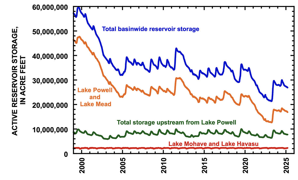
On 15 March, active storage in 46 reservoirs in the Colorado River watershed that are tracked by Reclamation in the Bureau’s Hydrodatabase[1] was 26.9 million af (acre feet), the same amount as on 21 July 2021 (Fig. 1). That amount was the third lowest total basin storage on 15 March of any year of the 21st century[2] and is approximately 45% of the total stored in these reservoirs the last time the basin’s reservoirs were relatively full in late July 1999[3]. On 15 March, 33% of the basin’s storage was in Lake Mead, 29% in Lake Powell, 29% in 42 reservoirs upstream from Lake Powell, and 9% in Lake Mohave and Lake Havasu[4]. These data remind us of the challenge in providing a secure and reliable water supply to the Southwest, southern California, and northwestern Mexico.
Figure 1. Graph showing total reservoir storage in 46 reservoirs reported by Reclamation in its Hydrodatabase (blue line), as well as the contents of Lake Mead and Lake Powell (orange line), 42 reservoirs upstream from Lake Powell (green line), and in Lake Mohave and Lake Havasu (red line). Data are between 1 January 1999 and 15 March 2025. Total basin reservoir storage today is the same as in late July 2021. Credit: Center for Colorado River Studies
It is instructive to remember how today’s small amount of reservoir storage was viewed when it occurred in summer 2021. On 27 July 2021, The New York Times posted the headline, “Two of America’s largest reservoirs reach record lows amid lasting drought.” That story led with these words, “The water level in Lake Powell has dropped to the lowest level since the U.S. government started filling the enormous reservoir on the Colorado River in the 1960s — another sign of the ravages of the Western drought.”[5] In the article, Wayne Pullan, Reclamation’s Upper Colorado Basin Regional Director, said, “This is a serious situation,” and Brad Udall said, “I’m struggling to come up with words to describe what we’re seeing here.” In mid-August 2021, Interior formally announced a water shortage in Lake Mead, triggering cuts on water deliveries, especially to Arizona farmers.
But today, there is less discussion about whether this small amount of reservoir storage represents a crisis. In part that may be because the season of snowmelt is ahead of us rather than behind us, as was the case in late July 2021. We hope that inflow this coming spring will recover some storage, but, this winter’s snowpack is merely average[6], and the basin’s soils are very dry. The Bureau of Reclamation’s “most probable” forecast of unregulated inflow to Lake Powell in 2025 is only 6.77 million af[7], 70% of the 30-year average and less than in 2024. Additionally, there may be little sense of concern, because we survived these conditions between July 2021 and March 2023. In fact, total basin storage plunged to only 21.3 million af in mid-March 2023. Perhaps, we are distracted by the engineering, legal, and political intricacies of the negotiations concerning post-2026 consumptive use and the seeming dysfunction of those negotiations. Perhaps, we are resigned to low reservoir storage as the new normal. Perhaps, we are the frog in the pot of water whose temperature is gradually rising, and we do not realize the water is about to boil.
Although significant strides have been made to conserve water, further reductions in water use throughout the basin are necessary, should we experience a succession of very dry years such as occurred between 2002 and 2004 and between 2020 and 2022. The post-2026 negotiations primarily have focused on strategies to reduce basin consumptive uses to match the 21st century’s declining supply, but today’s small amount of storage reminds us that it is critically important to also develop policies to recover reservoir storage to ensure security and reliability of the system.
To date, it has been exceptionally hard to recover storage. Despite the Lower Colorado River Basin System Conservation and Efficiency Program, the Upper Basin System Conservation Pilot Program, the Drought Response Operations Plan, Assigned Water development programs and large expenditures to reduce consumptive use using the Inflation Reduction Act, the Basin’s water managers have made no progress in rebuilding storage except that provided by the unusually large inflows of 2023. Between mid-July 2023 and mid-April 2024 (immediately prior to the onset of spring snowmelt inflows), the basin’s reservoirs were only drawn down by 2.2 million af, the smallest drawdown of total basin storage of the last 15 years[8]. However, the winter 2023/2024 snowpack yielded below average inflow to Lake Powell, and the basin only gained 2.5 million af of storage (Fig. 2). As of 15 March, the 46 reservoirs of the basin have been drawn down by 3.1 million af since the peak storage of those reservoirs in mid-July 2024. During the remainder of March and part of April, reservoir drawdown will continue to deplete storage originally accumulated in 2023.
Figure 2. Graph showing reservoir storage in different parts of the Colorado River basin between 1 January 2021 and 15 March 2025, summarizing periods of increase and decrease in total storage. Lake Mead, Lake Powell, and the 42 reservoirs upstream from Lake Powell each store approximately 30% of basin’s total storage. Credit: Center for Colorado River Studies
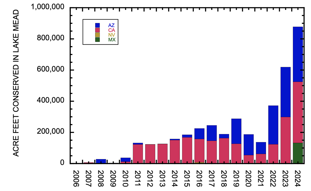
Low storage in Lake Mead persists despite 3.94 million af of water savings by the Lower Colorado River Basin System Conservation and Efficiency Program since 2006 (Fig. 3) and despite approximately 3.7 million af of Assigned Water development. Although additional savings are needed in 2025, the prospects of significant savings are not encouraging. Water users in the Lower Basin and Reclamation measure actual use and forecast trends in real time, and we anticipate 6.5 million af of main stem consumptive use by the three Lower Basin states. Commendably, this is less than the states’ nominal 7.5 million af/yr allocation under the Supreme Court defined allocation. Arizona is expected to take the largest share of those cuts, with projected main stem use of 2.1 million af, 74% of its nominal allocation. Nevada is projected to use 68% of its 300,000 af allocation, and California is projected to take 96% of its 4.4 million af allocation.[9] However, the Lower Basin’s projected 6.5 million af use is more than last year’s 6 million af of use. It is unclear the extent to which use in 2025 might fluctuate based on the available of federal funding to compensate water users for their conservation efforts, given the uncertainty enveloping federal policies under the new administration. We have no comparable set of numbers that allow evaluation of anticipated Upper Basin use and actual savings of wet water. [ed. emphasis mine]
Figure 3. Graph showing water conserved in Lake Mead resulting from the Lower Colorado River Basin System Conservation and Efficiency Program and conservation efforts in Mexico. Credit: Center for Colorado River Studies
Deficit spending is likely to continue between now and mid-April and will primarily be from Lake Mead and Lake Powell, because the total storage in the 42 reservoirs upstream from Lake Powell is no longer being depleted[10]. The basin-wide spatial pattern of reservoir operations in late winter and early spring 2025 has been storage of water in small upstream reservoirs and continued withdrawal of water from some CRSP facilities including Lake Powell, and recently from Lake Mead. Draw down continues at Granby (the primary storage facility of the trans-basin Colorado-Big Thompson Project), Blue Mesa, Navajo, Fontenelle, and several smaller reservoirs[11]. These Upper Basin depletions have been somewhat offset by small amounts of accumulation at other reservoirs[12]. Flaming Gorge Reservoir, the largest facility upstream from Lake Powell, was at its lowest at the very end of January and increased 41,100 af of storage in February and the first half of March. In contrast, the total contents of Lake Powell and Lake Mead continue to be drawn down. Lake Powell was at its highest on 1 January 2025, has lost 803,000 af of storage since that time, and will probably continue to decline for another month, based on projections by Reclamation[13]. Lake Mead increased in storage after 1 January, peaked in late February, and subsequently lost 74,000 af. Last year, storage in Lake Mead continued to be lost until early August, and the same pattern is likely this year. The total loss of storage in Lake Powell and Lake Mead between 1 January and 15 March was 476,000 af. The rate of loss from the Mead-Powell system for the next few weeks will be determined by the balance between inflows to Lake Powell and releases from Lake Mead.
[2] Total active storage in the same 46 reservoirs on 15 March 2025 was less than on the same date in 2022 (23.5 million af) and in 2023 (21.3 million af).
[3] On 21 July 1999, total active storage in the same 46 reservoirs was 59.5 million af.
[4] Lake Mead stored 9.01 million af, Lake Powell stored 7.85 million af, the 42 reservoirs upstream from Lake Powell stored 7.74 million af, and 2.30 million af were in Lake Mohave and Lake Havasu on 15 March.
[5] On 27 July 2021, active storage in Lake Powell was 7.90 million af, approximately the same as today.
[6] On 20 March 2025, snow water equivalent (SWE) in the Upper Colorado Region was 97% of median with 18 days remaining until the annual peak SWE typically occurs.
[8] This comparison is for the reservoir drawdown between the mid-summer peak and the following spring’s minimum storage prior to the next year’s runoff. The smallest draw down of total basin reservoir storage in the recent 15 years was between 13 July 2023 and 17 April 2024 (2.15 million af). The second smallest drawdown was 2.61 million af between 6 July 2014 and 4 May 2015. Drawdown was 2.56 million af between 4 August 2011 and 30 April 2012 and was 2.82 million af between 28 July 2019 and 29 April 2020.
[10] Maximum draw down of these Upper Basin reservoirs was 1.49 million af on 26 February 2025.
[11] Net drawdown exceeding 1,000 af between early January and mid-March occurred at Granby (69,600 af), Williams Fork (6,570 af), Dillon (4,520 af), Green Mountain (8,940 af), Ruedi (5,310 af), Taylor Park (1,790 af), Blue Mesa (17,200 af), Fontenelle (54,100 af), Upper Stillwater (1,230 af), and Navajo (28,400 af) Reservoirs.
[12] Reservoirs accumulating more than 1,000 af storage between January and mid-March were Willow Creek (1,300 af), Rifle Gap (2,600 af), Vega (1,400 af), Crawford (1,750 af), Big Sandy (1,670 af), Eden (1,150 af), Meeks Cabin (2,290 af), Red Fleet (1,030 af), Steinaker (2,910 af), Strawberry (7,050 maf), Starvation (15,200 af), Moon Lake (3,180 af), Scofield (4,950 af), and Vallecito (6,060 af) Reservoirs.