Snowfall in March has helped decrease the likelihood of drought developing this spring in Colorado’s northwest mountains. However, a warm and dry spring could still change the tide heading into summer. The National Weather Service, a division of the National Oceanic and Atmospheric Administration, released its latest seasonal drought outlook on Thursday, March 20. It showed that drought conditions are unlikely to develop in most of northwest Colorado through June…Brad Pugh, a forecaster with the National Oceanic and Atmospheric Administration’s climate prediction center, said these outlooks predominantly take into account the current conditions, climatology temperature and precipitation outlooks over the next three months.
“In northwestern Colorado at this time of year, you know going into the springtime, mountain snowpack is a critical factor,” Pugh said.
As of March 18, much of northwest Colorado was in line with, or just above, normal snowpack. This has continued to improve in the state’s north-central mountains since January. According to OpenSnow, as of Monday the snow totals and percentage of normal on the season so far were as follows:
Winter Park – 315 inches (117%)
Copper Mountain Resort – 303 inches (113%)
Vail Mountain – 292 inches (101%)
Breckenridge Ski Resort – 284 inches (107%)
Steamboat Resort – 279 inches (108%)
Aspen Highlands — 267 inches (88%)
Loveland Ski Area – 261 inches (108%)
Snowmass – 243 inches (83%)
Keystone Resort – 239 inches (107%)
Beaver Creek – 227 inches (108%)
Arapahoe Basin Ski Area – 225 inches (112%)
Aspen Mountain – 210 inches (92%)
Ski Cooper – 206 inches (106%)
Buttermilk – 147 inches (89%)
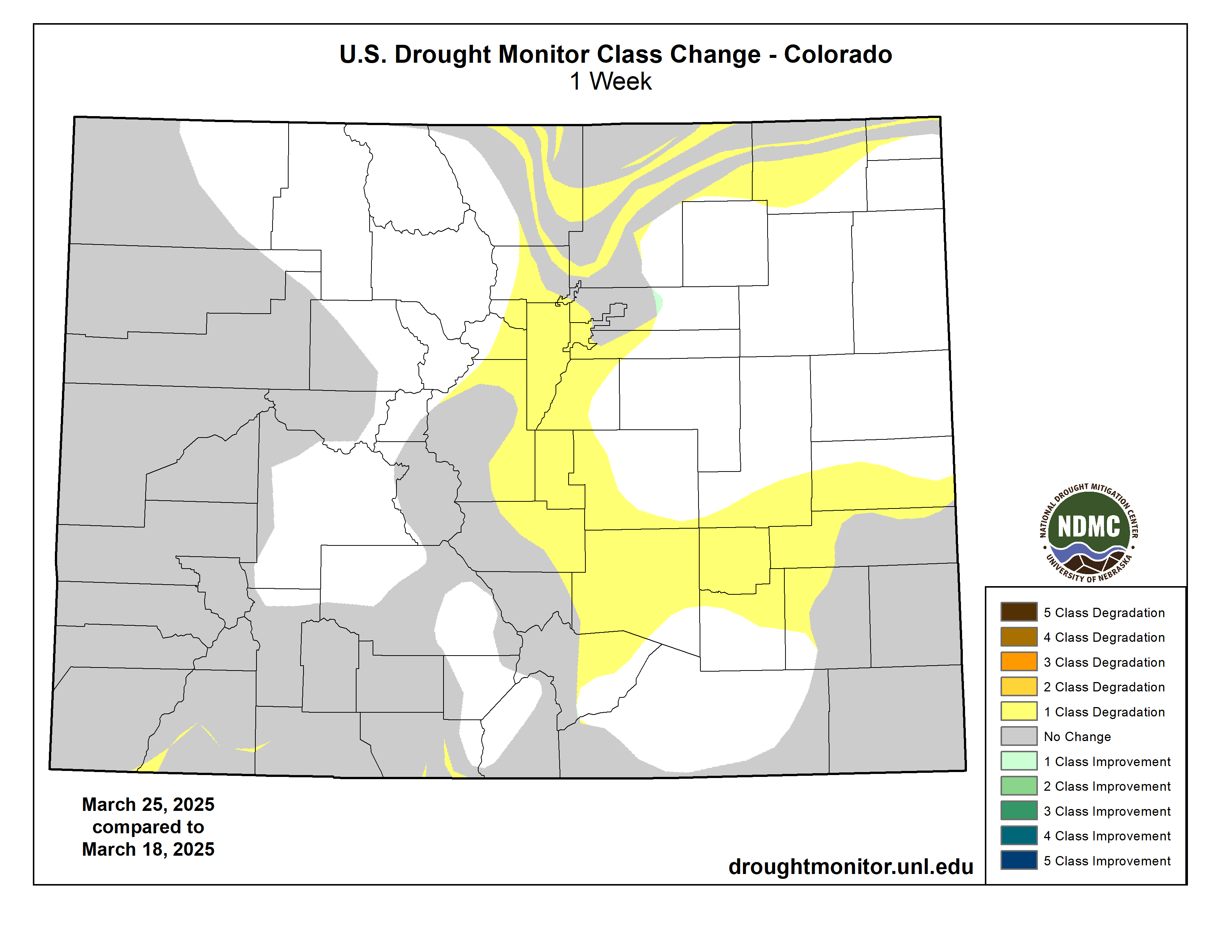
Colorado Drought Monitor map March 25, 2025.
The latest U.S. Drought Monitor for Colorado reported no drought in many of the northwest counties including Summit, Grand, Routt and Jackson counties as well as the eastern reaches of Eagle and Moffat counties. Heading west, the monitor shows abnormally dry conditions in Pitkin County and the eastern portions of Garfield and Rio Blanco counties. Conditions continue to get progressively drier the further west toward the border.
A view of one of the Valley’s major agriculture resources, cattle. Credit: Owen Woods
Click the link to read the article on the Alamosa Citizen website (Heather Dutton and Emily Wolf):
March 27, 2025
Here in the San Luis Valley, water is deeply connected to our way of life. The Rio Grande, its tributaries and connected groundwater support local heritage, agriculture, recreation and the natural environment. Like all of the region’s streams and rivers, the Rio Grande is critical to the livelihood and economies of the communities of the SLV and is a growing recreational and economic asset to communities outside of the Valley as well.
Photo credit: Sinjin Eberle/American Rivers
To help illustrate the critical value water plays across all sectors in the Valley, American Rivers and One Water Econ released a new study this week, The Economic Value of Water Resources in Colorado’s San Luis Valley, which presents the economic benefits of key sectors and services that depend on water in the Valley. The analysis looks at irrigated agriculture, municipal and industrial uses, tourism and recreation, and environmental values like wildlife habitat.
While we all know and understand the intrinsic value of water in the Valley, economic data will further elevate not only the social importance of water, but also the economic contributions the Rio Grande and Conejos River, other streams, and connected groundwater provide to the San Luis Valley. Our community can use this economic data to tell the story of ongoing collaborative water management projects, help fight future threats, including groundwater export schemes, and make the case for multi-benefit river restoration efforts that are a win-win-win for agriculture, communities, and the environment.
San Luis People’s Ditch March 17, 2018. Photo credit: Greg Hobbs
Irrigated agriculture, a key economic driver in the SLV, is reliant on the surface water flowing through the Valley along with the vast number of groundwater wells and is deeply connected to the history of the Valley. The study found that crops supported by surface and groundwater make up 39 percent of Colorado’s total agricultural output, despite the population of the Valley being less than 1 percent of Colorado’s population. Additionally, irrigated agriculture was found to contribute more than $480 million annually in economic output. For every $1 that is spent on local inputs for agriculture production, an additional $1.56 is generated in the regional economy. Potatoes and vegetables are the largest economic generators in the agricultural space, with an annual economic output of $184 million. Not only does irrigated agriculture provide critical economic benefits, but the irrigated fields and wet meadows also support critical migratory bird habitat.
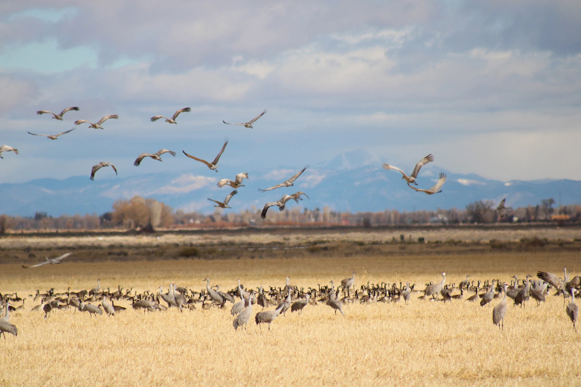
Sandhill cranes stop and gather in a field near the Monte Vista National Wildlife Refuge during their yearly trek.
Recreation, a growing economic sector for the Valley, is heavily reliant on water flowing from the surrounding mountains into the Valley and provides significant economic value. The Great Sand Dunes National Park and Preserve attracts national and international travelers, as do the world-class birding and wildlife viewing opportunities at the nine state and national wildlife refuges that are made up of wetland, riparian, and open water ecosystems, and support numerous species of resident and migratory birds, including sandhill cranes. Additionally, the Rio Grande and Conejos River draw many visitors for both whitewater boating and world class fishing. The recent economic analysis found water-related recreation provides $213.7 million in benefits annually in the San Luis Valley, and for every $1 spent on recreation, $1.91 is generated through ripple effects within the local economy. The Valley’s riverside lands, wetlands, and wet meadows are a critical part of the natural infrastructure supporting recreation and many species of wildlife. The analysis found that water-related habitat in the Valley is valued at more than $49 million annually and the annual Crane Festival generates $4 million in direct revenue from visitor spending.
Many other industries beyond recreation and agriculture also rely on water – local breweries, distilleries, bakeries, greenhouses, hospitals, and hotels among others – all rely on water. These “water-dependent” industries (WDIs) generally rely on the services of water utilities to support and grow their businesses. Water-dependent industries in the Valley support nearly $1.3 billion annually in total economic output. Water is undeniably a critical resource for the Valley, providing not only economic benefits but other ecosystem services, and intrinsic and cultural values. The economic data from this new analysis provides San Luis Valley communities with information to help protect the Valley from export schemes, further support water projects that conserve the Valley’s precious resources, and illustrate to those outside the Valley why water is so critical to the livelihoods of every person in the SLV.
Partners involved in the creation of the study from American Rivers, One Water Econ, and the San Luis Valley Water Conservancy District will present information about the study at the Rio Grande State of the Basin Symposium at Adams State University on March 29. The event is open to the public and all are encouraged to attend. The analysis is also available on American River’s website at www.americanrivers.org/SLVEconomicReport.
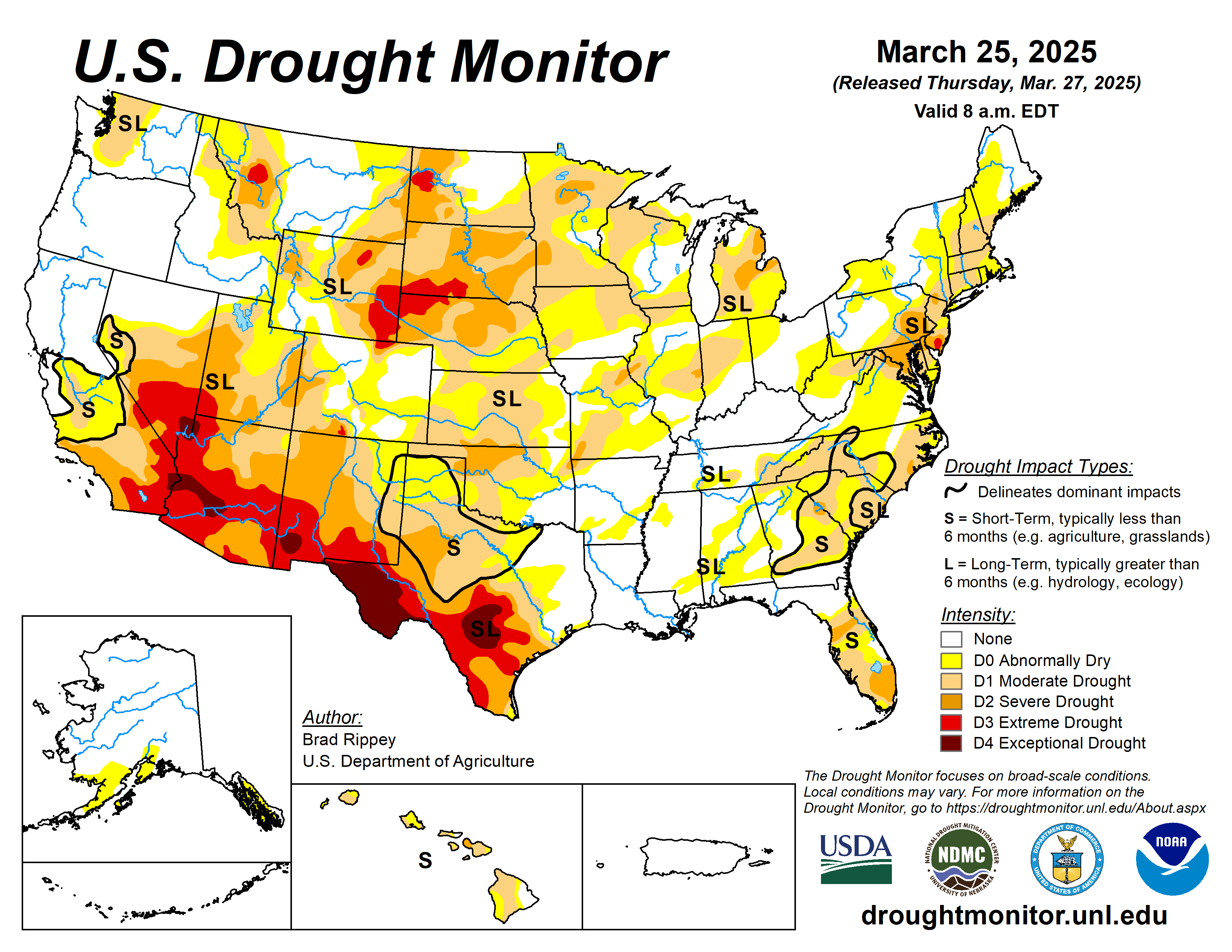
On March 18—for the second time in 5 days—a ferocious dust storm across the southern High Plains and neighboring regions led to sharp visibility reductions and increasingly stressful conditions for rangeland, pastures, and winter grains. The dust, lofted by high winds, was drawn into a storm system crossing the central Plains and upper Midwest, leading to widespread reports of “dirty” rain and snow. On March 19-20, significant accumulations of wind-driven snow occurred from parts of Kansas and Nebraska into northern Michigan, while locally severe thunderstorms erupted across the Midwest. More than a dozen tornadoes were spotted on March 19 across Illinois and Indiana. Farther east, however, parts of the Carolinas experienced a rash of spring wildfires, with the Black Cove and Deep Woods Fires near Saluda, North Carolina, collectively charring some 6,000 acres of vegetation and destroying at least 20 structures. Some of the fuel for fires in the Carolinas was provided by trees downed by Hurricane Helene about 6 months ago. Elsewhere, dry weather dominated the southern Plains and the Southwest, while late-season precipitation fell in northern and central California and the Northwest. According to the California Department of Water Resources, the average water equivalency of the high-elevation Sierra Nevada snowpack climbed nearly to 25 inches, essentially ensuring a normal seasonal accumulation. For the second week in a row, near- or below-normal temperatures dominated the West, although warmer weather arrived late in the drought-monitoring period. Conversely, warm weather prevailed in many areas east of the Rockies, with consistently chilly conditions limited to portions of the nation’s northern tier…
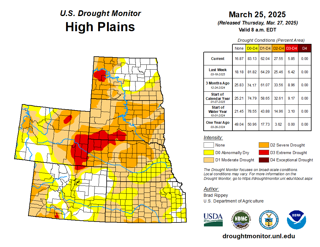
Major storm systems continued to “undercut” the Dakotas and portions of neighboring states. Notably, severe drought (D2) was broadly expanded in South Dakota, where season-to-date snowfall totals were broadly at least 1 to 2 feet below average. With the northern Plains’ drought occurring at multiple time scales, current impacts include poor conditions for rangeland, pastures, and winter wheat. In contrast, late-season storminess across the northern Intermountain West, including much of northern and western Wyoming, led to improved mountain snowpack, more favorable spring and summer runoff prospects, and reductions in drought coverage and intensity…
Colorado Drought Monitor one week change map ending March 25, 2025.
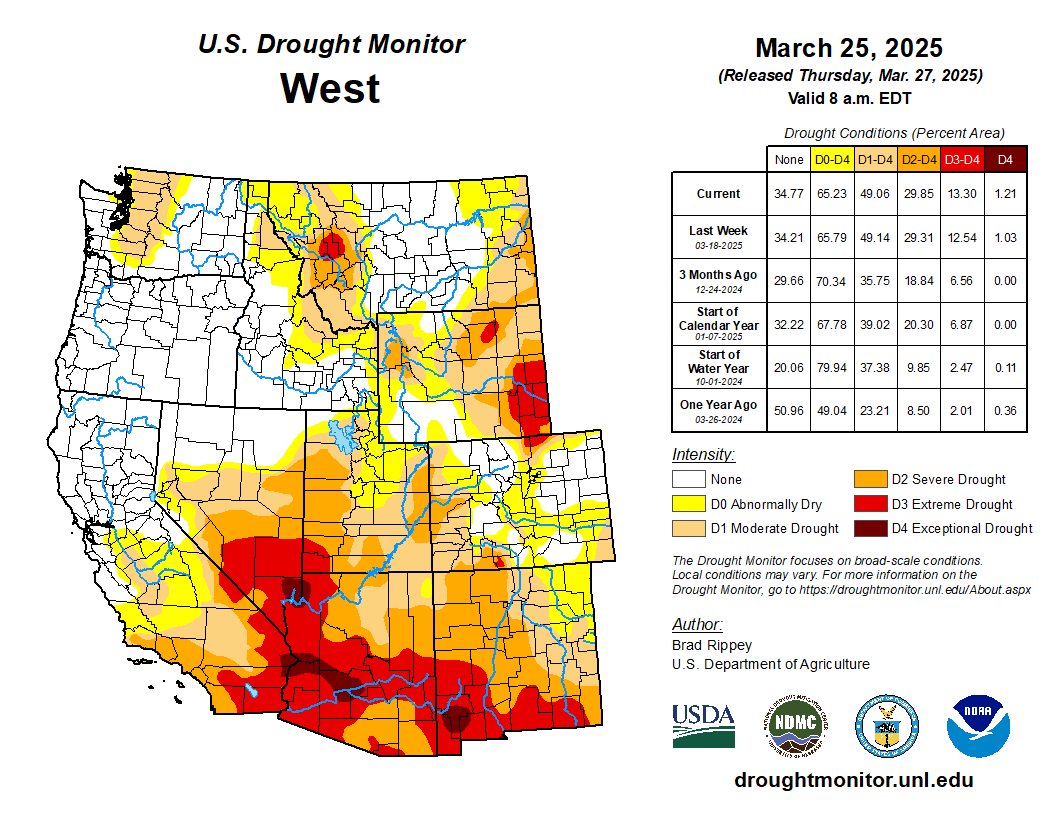
Occasional precipitation continued to fall across roughly the northern half of the region, further improving high-elevation snowpack, as well as spring and summer runoff prospects. Drought improvements of up to one category were introduced from the northern Great Basin to the northern Rockies. Meanwhile, dry weather returned across the Southwest, following some late-season precipitation that was heaviest in parts of southern California but did not reach the southern Rockies. In fact, significant increases of all drought categories were introduced in New Mexico, parts of which have been affected by the same windy, dusty weather that has been plaguing the southern Plains…
Drought-related impacts further spread and intensified across parts of Texas and Oklahoma, amid March winds, dust, and dryness. In fact, two previously separate areas of drought were connected across Texas and Oklahoma. Meanwhile, little rain has fallen since mid-February across Arkansas and portions of neighboring states. While the short-term dryness has been favorable for spring fieldwork, rain will soon be needed across the mid-South for pastures, fall-sown small grains, and recently planted summer crops. By March 23, nearly one-half (46%) of the intended rice acreage had been planted in Louisiana, along with 36% in Texas. In Arkansas, 10% of the corn and 2% of the rice had been planted by March 23, while 7% of the winter wheat had headed. Pastures in Arkansas—rated 27% very poor to poor on March 23—were just starting to exhibit some stress from short-term dryness. On that date, rangeland and pastures in Texas were in much worse shape (71% very poor to poor), reflecting drought at multiple time scales and the impact of recent blowing dust…
Looking Ahead
Drought-easing rain across southern Texas will gradually shift eastward along the Gulf Coast. Five-day rainfall totals could reach 2 to 8 inches or more across the western half of the Gulf Coast region, with higher totals leading to flooding in southern and coastal Texas. Meanwhile, active weather will also prevail in the vicinity of a nearly stationary front draped across the northern United States. The front will separate cold air to the north from warmth farther south, with accumulating snow expected during the weekend from parts of the northern Plains eastward into northern New England. Meanwhile, Midwestern 5-day rainfall could total 1 to 2 inches, accomdpanied at times by locally severe thunderstorms. Elsewhere, persistent low pressure near the northern Pacific Coast will maintain showery, unsettled conditions from the Northwest to the northern Rockies, while mostly dry weather will persist in the Southwest, despite a cooling trend.
The NWS 6- to 10-day outlook for April 1-5 calls for above-normal precipitation nearly nationwide, with northern and central California and the western Great Basin having the greatest likelihood of experiencing wet conditions. Elevated odds of near- or below-normal precipitation should be limited to southern Texas. Meanwhile, warmer-than-normal weather from the southern half of the Plains to the middle and southern Atlantic Coast should contrast with below-normal temperatures in the Far West and across the nation’s northern tier.
US Drought Monitor one week change map ending March 25, 2025.
Blanca Wetlands, Colorado BLM-managed ACEC Blanca Wetlands is a network of lakes, ponds, marshes and wet meadows designated for its recreation and wetland values. The BLM Colorado and its partners have made strides in preserving, restoring and managing the area to provide rich and diverse habitats for wildlife and the public. To visit or get more information, see: http://www.blm.gov/co/st/en/fo/slvfo/blanca_wetlands.html. By Bureau of Land Management – Blanca Wetlands Area of Critical Environmental Concern, Colorado, Public Domain, https://commons.wikimedia.org/w/index.php?curid=42089248
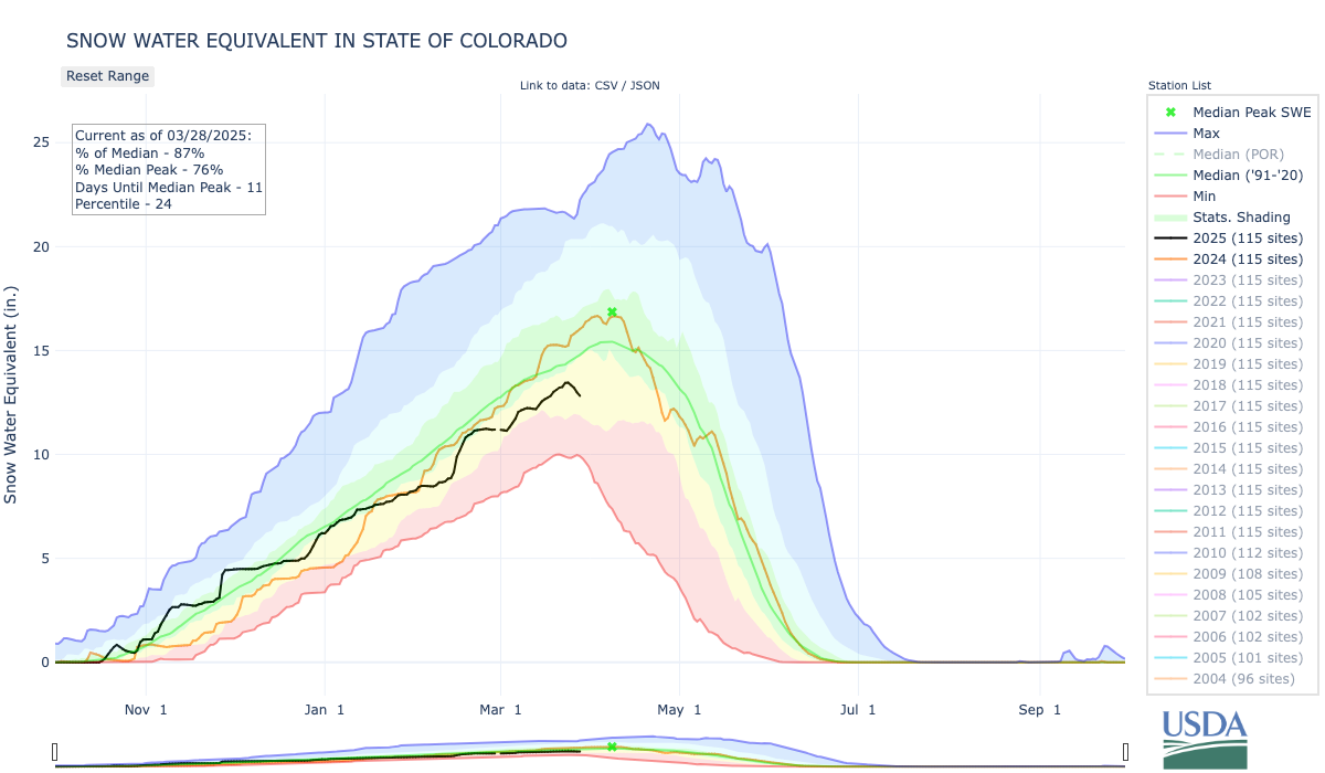
The pressure is on: Colorado’s average snowpack statewide masks worrisome water conditions in the south, where water providers are banking on more storms to boost water supplies before snowmelt begins in April.
Much of Colorado’s annual water supply is stored in its winter snowpack, which builds up until early April when it melts and flows into soils, streams and reservoirs. Statewide, Colorado is headed toward that April 8 peak with 92% of its normal snowpack for this time of year. But conditions vary widely from north to south and within individual river basins, leaving some water experts concerned about drought, wildfires and reservoir levels, officials said during a Water Conditions Monitoring Committee meeting Tuesday.
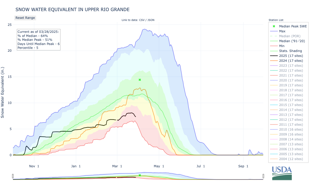
One of those experts is Pat McDermott, who is based in the Upper Rio Grande River Basin in south-central Colorado, where the snowpack is 69% of the norm from 1991 to 2020.
“We need to keep having snow. This has been a dismal year for snowpack accumulation,” McDermott, a staff engineer for the Colorado Division of Water Resources, said Tuesday. “We had a whole month and a half — from Dec. 1 to Jan. 15 — when it hardly snowed a speck.”
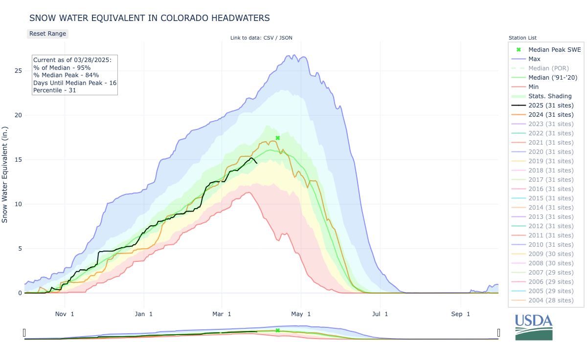
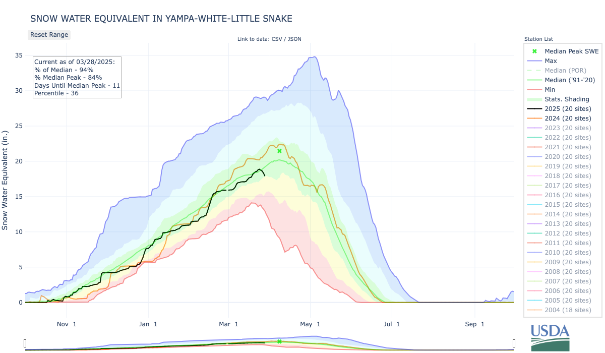
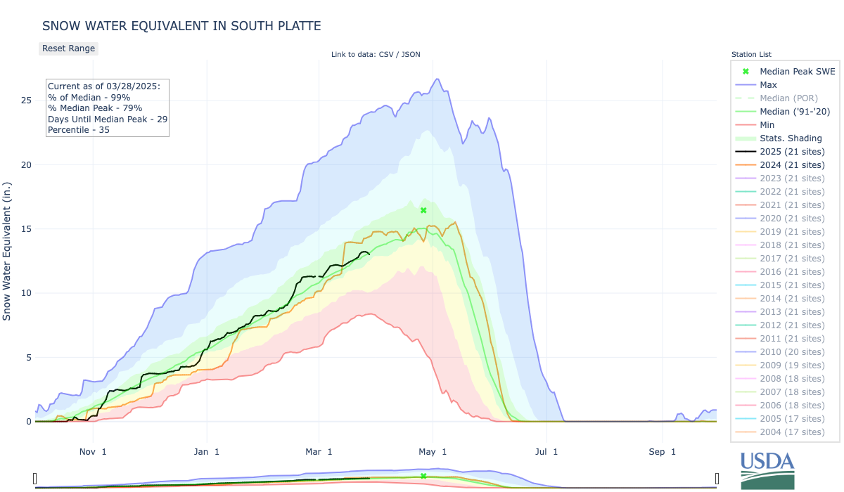
The Colorado Headwaters Basin, where the Colorado River begins; the Yampa-White-Little Snake combined basin, which supplies Western Slope communities in the northwestern corner of the state; and the South Platte Basin, which feeds rivers on the Front Range, are all in good condition.
The Laramie and North Platte combined basin was the only region with a higher-than-average snowpack, measuring about 103% of the median compared to the 30-year period as of Tuesday. There is a storm in the forecast this week — both small positive notes for an area dealing with persistent drought conditions after a dry summer in 2024.
The snowpack in these regions typically peaks between April 8 and April 26.
With these conditions heading into spring runoff, officials have an eye out for flooding. Flood risk from snow runoff might be suppressed in areas where the snowpack is lower than average, said Kevin Houck, chief of watershed and flood protection at the Colorado Water Conservation Board, which hosts the monthly water conditions meeting.
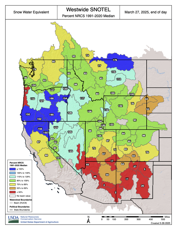
Westwide SNOTEL basin-filled map March 27, 2025 via the NRCS.
Some of these northern basins, like the Yampa-White-Little Snake basin, are heading into the summer with little drought and average reservoir levels in addition to the normal snowpack.
In southern parts of the state, it’s the opposite.
Experts are scouring the data. They’re gauging moisture in the soil, pre-runoff reservoir conditions and weather forecasts for the next three months.
Their goal is to assess whether regions are being dealt a bad hand.
A poor snowpack can mean less water flowing into rivers and streams. Some of that subpar runoff can get sucked up by dry soils. That leaves even less water flowing into reservoirs that are already low. Sparse storms in the forecast, and warm or dry conditions can just make matters worse.
These compounding factors elevate concerns about wildfire risk and raise the odds that farmers will have to reduce their crop output because they won’t have enough irrigation water.
That’s what happening in southern Colorado with more warm and dry weather on the horizon.
“That is not the kind of outlook that we like to see at this point either,” said Russ Schumacher, the state climatologist, in a presentation during Tuesday’s water conditions meeting.
Spotlight on the Upper Rio Grande
Down in the south-central region of the state, McDermott is worried.
At the summit of Wolf Creek Pass, the snowpack is 66% of normal. But down the pass toward Pagosa Springs and the rest of the San Juan River Basin, the snowpack is 45% of average.
“It’s worse this year at Wolf Creek than it was on the same date in 2018, so we’re using 2018 as a potential forecast point here in the Upper Rio Grande Basin this year,” McDermott said. “Of course, 2018 was a terrible year.”
That year, the snowpack peaked March 30 with 6.9 inches of liquid water in the snow. It normally peaks on April 3 with 14.4 inches, according to federal data. Runoff plummeted and ended a month early.
This year, the basin had 7.9 inches of liquid water in the snow as of Tuesday.
In the Upper Rio Grande River Basin, there are two positives to consider: The region had good precipitation heading into the winter, which locked more moisture into the frozen soils, and some of the smaller basins have a better snowpack than others.
On the east side of the San Luis Valley, the snowpack in the Sangre de Cristo mountains varies from 30% to 96% of normal in basins that are mere miles from each other. The snowpack near Great Sand Dunes National Park is at 6%.
“It looks like it’s going to be below normal over there on the Sangre de Cristos, but depending on which little basin you’re in, you may have a little better year than others,” McDermott said.
March, normally the region’s snowiest month, has not served up enough snow to make up for the dry winter. It’ll need more snow just to hold onto that before spring runoff starts, he said. The region’s snowpack typically reaches its peak accumulation April 3.
Climate models indicate less than the normal amount of precipitation across southern Colorado for the next week.
McDermott predicted that it will be one of the top 10 worst runoff seasons basinwide since 1900, during the water meeting Tuesday. The basin is heading into a subpar spring runoff with reservoirs that are already low, holding just 20% to 60% of their full capacity.
Sanchez Reservoir stored about 5,000 acre-feet of its 100,000-acre-foot capacity as of Tuesday. One acre-foot of water equals about 325,850 gallons of water and can supply roughly two to four households for one year.
“We’re a little hamstrung,” McDermott said. “We’re running what appears to be a dry year.”
The future outlook does not offer much relief to the basin or other regions of southern Colorado.
The two-week forecast shows higher temperatures across the state, and less-than-average precipitation in the southeastern region, Schumacher said.
Colorado Drought Monitor March 25, 2025.
Drought conditions are already creeping into the Western Slope, although drought conditions have improved along the Front Range, north-central Colorado and the Eastern Plains. By June, the wildfire risk is expected to be above normal for the southwestern corner of the state, Schumacher said.
“The news is probably tilted towards the bad side in terms of drought,” he said.