#Drought news March 20, 2025: Dire conditions have developed in recent days across the southern Plains, where any benefit from last November’s record-setting rainfall is quickly diminishing

Click on a thumbnail graphic to view a gallery of drought data from the US Drought Monitor website.

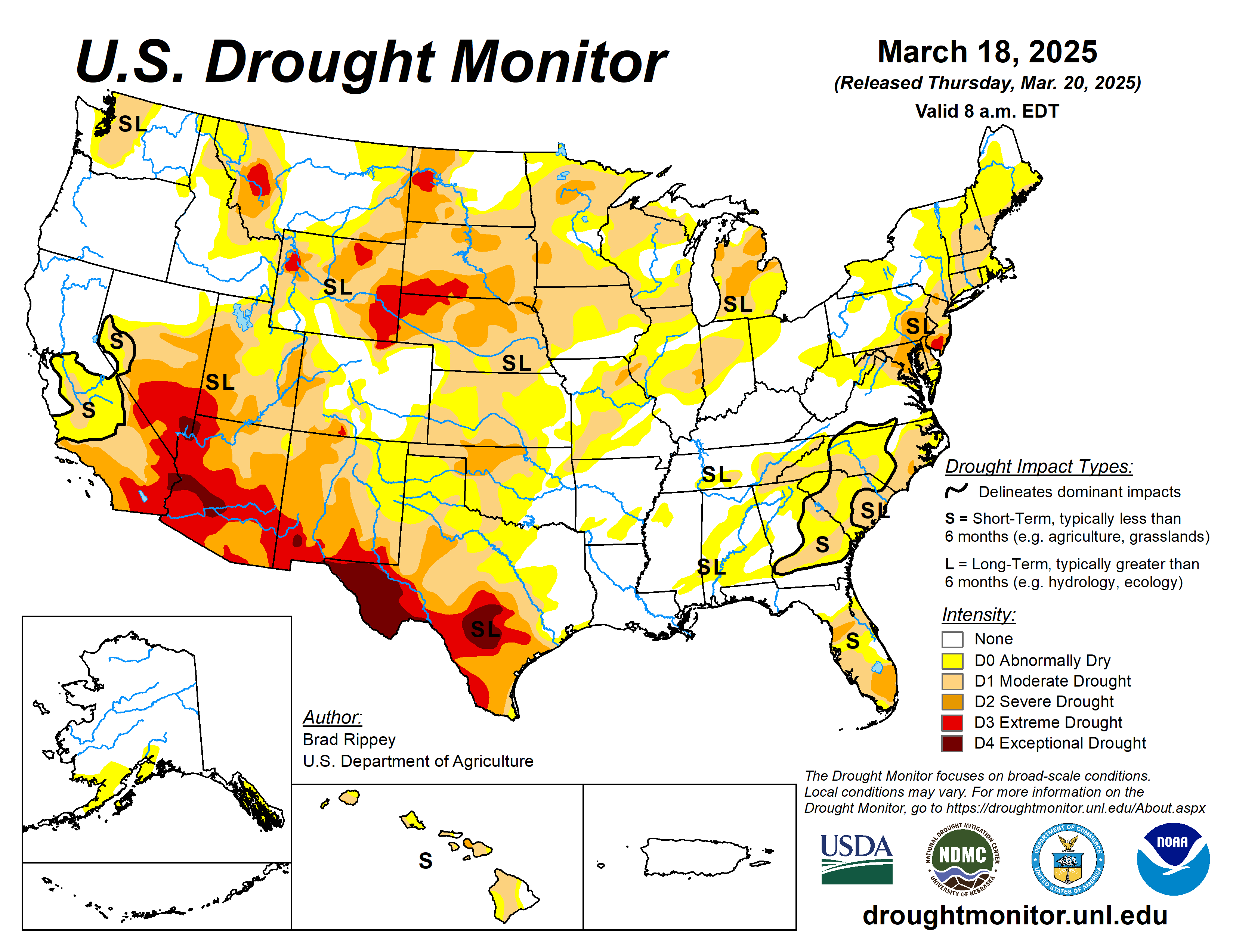
Click the link to go to the US Drought Monitor website. Here’s an excerpt:

This Week’s Drought Summary

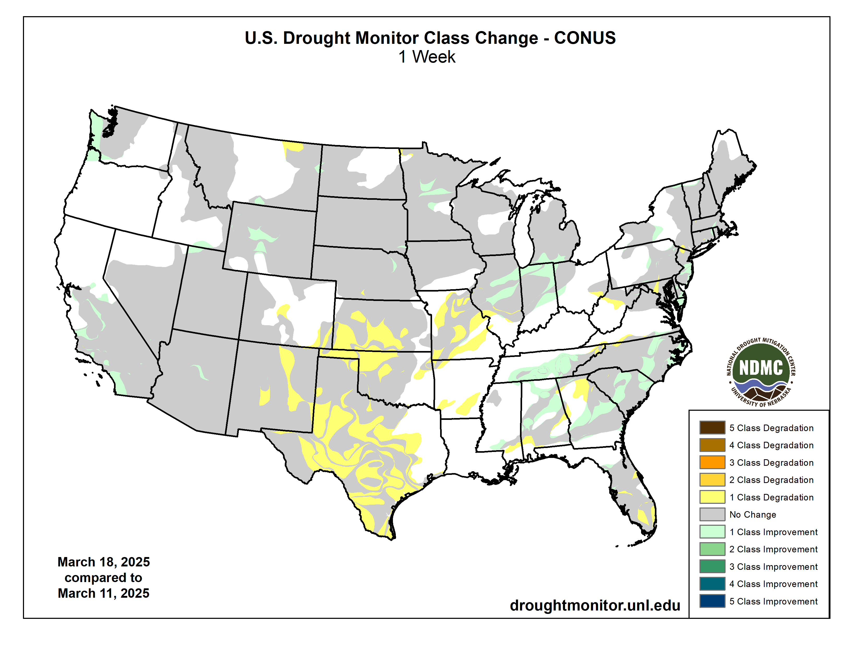
For the drought-monitoring period ending the morning of March 18, significant precipitation fell in parts of the eastern and western United States, while warm, dry, windy weather led to worsening drought across portions of the central and southern Plains and neighboring regions. In recent days, major spring storms have fueled an extraordinarily active period of U.S. weather, featuring high winds, blowing dust, fast-moving wildfires, severe thunderstorms, torrential rain, and wind-driven snow. Some locations experienced multiple hazards within hours, or even simultaneously. High winds and blowing dust were especially severe across the southern High Plains and parts of the Southwest on March 14 and 18, with some locations reporting wind gusts topping 80 mph and visibilities of one-half mile or less. In Oklahoma alone, mid-March wildfires tore across at least 170,000 acres of land and destroyed more than 200 residences. Farther north, wind-blown snow affected portions of the central Plains and upper Midwest, mainly on March 15—and again on March 19-20, early in the new drought-monitoring period. Meanwhile, a severe weather outbreak from March 14-16 spawned nearly 150 tornadoes from the mid-South into the eastern U.S., based on preliminary reports from the National Weather Service. Early reports indicated that the extreme weather resulted in dozens of fatalities, with causes of death ranging from wildfires to tornadoes to chain-reaction collisions. Elsewhere, occasionally heavy precipitation locally trimmed drought severity, with some of the most extensive improvement occurring in the Southeast…
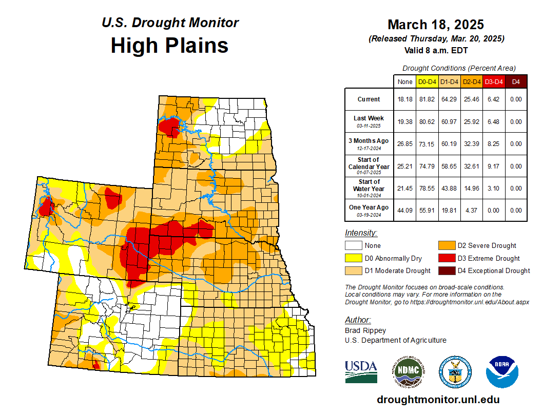
High Plains

Significant changes were largely limited to Kansas, where expansion or introduction of dryness (D0) and moderate to severe drought (D1 to D2) resulted from mostly warm, dry, windy weather. By March 16, the U.S. Department of Agriculture indicated that statewide topsoil moisture in Kansas was rated 47% very short to short. Elsewhere, some drought improvement was introduced in central Wyoming, largely based on favorable snowpack observations…

Colorado Drought Monitor one week change map ending March 18, 2025.

West

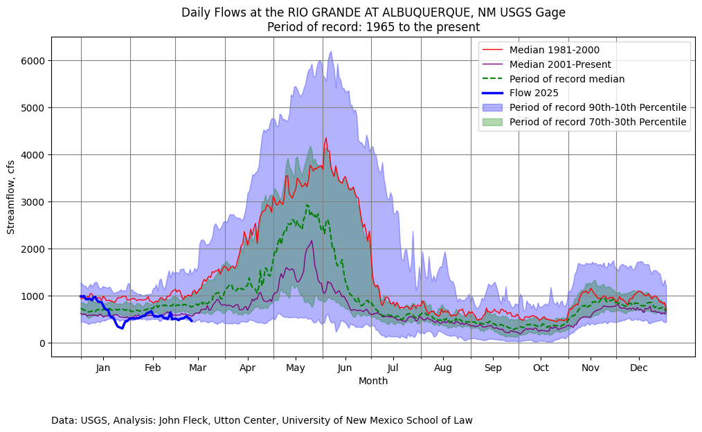
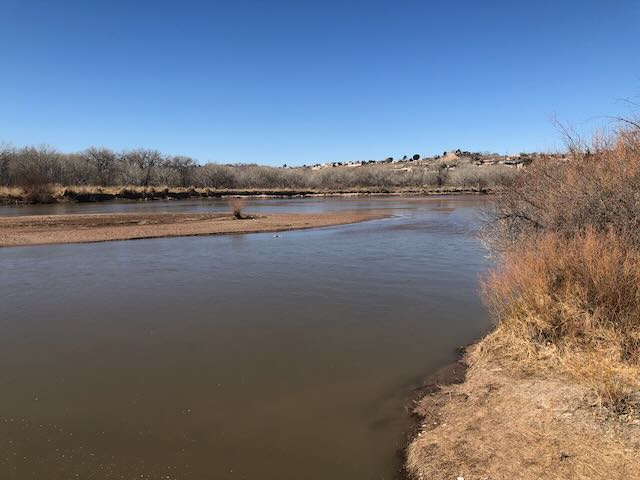
A pair of Pacific storms system delivered widespread precipitation, which was heaviest along the West Coast and in the Cascades and Sierra Nevada. Parts of central and southern California and the Pacific Northwest noted up to one category of drought improvement. According to the California Department of Water Resources, the water equivalency of the high-elevation Sierra Nevada snowpack improved to nearly 25 inches by March 18, effectively ensuring a “normal” season. Notably, snowpack in the southern Sierra Nevada has greatly improved with recent storms, following an imbalanced start to the winter wet season during which much heavier precipitation fell in the northern Sierra Nevada. Although meaningful precipitation extended into the Southwest, snowpack deficits are so significant that any improvement in the overall drought and water-supply situation has been extremely limited. Additionally, harsh winds across the lower Southwest have led to extensive blowing dust in recent days, particularly across the areas of southern New Mexico experiencing severe to exceptional drought (D2 to D4)…

South

Dire conditions have developed in recent days across the southern Plains, where any benefit from last November’s record-setting rainfall is quickly diminishing. During major dust storms on March 14 and 18, wind gusts in Lubbock, Texas, were clocked to 82 and 78 mph, respectively. The March 14 gust was a spring (March-May) record for Lubbock—and marked the highest non-convective gust on record in that location. As the dust blew on March 14, numerous wildfires raged in Oklahoma, as well as neighboring areas in southern Kansas and the northern panhandle of Texas. The dusty scene was repeated on March 18, with visibilities as low as one-quarter to one-half mile widespread across western Texas. According to the U.S. Department of Agriculture, statewide topsoil moisture in Texas was rated 71% very short to short on March 16, while 71% of the rangeland and pastures were rated in very poor to poor condition. For the week ending March 18, broad expansion of all drought categories was noted in Oklahoma and Texas. Farther east, however, heavy rain led to large reductions in the coverage of dryness and drought in much of Tennessee.

Looking Ahead

A low-pressure system moving into eastern Canada on Thursday will drag a cold front through the eastern United States. Locally severe thunderstorms may affect the middle Atlantic States on Thursday, followed by widespread Northeastern precipitation—rain and snow—lingering through Friday. Meanwhile, conditions across the nation’s mid-section will improve, following Wednesday’s blizzard from the central Plains into the upper Midwest and a widespread high-wind event. Still, an elevated wildfire threat will persist at least through Friday in parts of the south-central U.S., including the southern High Plains. Farther north, a pair of Pacific disturbances will move eastward near the Canadian border. The initial system will be fairly weak, but the second storm will intensify during the weekend across the northern Plains and upper Midwest. Impacts from the latter system, which will persist into early next week, should include late-season snow from the Cascades to the Great Lakes region; another round of windy weather across the nation’s mid-section; and potentially severe thunderstorms across portions of the South, East, and lower Midwest.

The NWS 6- to 10-day outlook for March 25-29 calls for the likelihood of near- or below-normal temperatures in most areas from the Mississippi River eastward, while warmer-than-normal weather will broadly prevail from the Pacific Coast to the Plains. Meanwhile, near- or above-normal precipitation across much of the country should contrast with drier-than-normal conditions in the Southeast, excluding southern Florida, and an area stretching from the Four Corners region to the central High Plains. Areas with the greatest likelihood of experiencing wetter-than-normal weather include southern Texas and the Pacific Northwest.

US Drought Monitor one week change map ending March 18, 2025.

Governor Polis Appoints Three New Members to #Colorado Water Conservation Board

Colorado Rivers. Credit: Geology.com

Click the link to read the release on the Colorado Water Conservation Board website (Katie Weeman):

March 18, 2025

Colorado Governor Jared Polis announced this week three new representatives will be joining the Colorado Water Conservation Board (CWCB): Taylor Hawes, Greg Johnson and Mike Camblin.

The 15-member Board includes nine representatives from each major Colorado river basin as well as the Denver metro area who are appointed by the Governor and then must be confirmed by the Colorado State Senate. The Board also includes six state officials including Colorado Water Conservation Director Lauren Ris, Colorado Department of Natural Resources Executive Director Dan Gibbs, Colorado Commissioner of Agriculture Kate Greenberg, State Engineer and Director Colorado Division of Water Resources Jason Ullmann, Director Colorado Parks and Wildlife Jeff Davis and Colorado Attorney General Phil Weiser. Board members have experience and expertise in water resource management, water project financing, engineering, water law, farming, ranching and more.

“We are thrilled to welcome these new members to our Board. Each of them brings invaluable expertise—from collaborative water management to policy and planning to on-the-ground perspective in agriculture,” said Lauren Ris, CWCB Director. “Their diverse backgrounds will strengthen our work to create a sustainable water future for Colorado, and I look forward to the insight and leadership they will bring.” 

New Colorado Water Conservation Board Members include: 

Taylor Hawes, Colorado River Program director for the Nature Conservancy.

Taylor Hawes of Silverthorne, Colorado, who joins the Board as a representative of the Colorado Basin. Hawes serves as the Colorado River Program Director for The Nature Conservancy, leading efforts to balance the needs of people and nature. With nearly three decades of experience in water law, policy and planning, she has worked extensively with diverse stakeholders, including state and federal agencies, conservation groups and major water users. She previously served as Associate Counsel for the Colorado River Water Conservation District, held board appointments with the Colorado River District and Water Education Colorado, as well as leadership roles on the Colorado Interbasin Compact Committee, the Colorado River Basin Water Supply and Demand Study and other collaborative initiatives.

Greg Johnson via his LinkedIn page.

Greg Johnson of Denver, Colorado, who joins the Board as a representative of the City and County of Denver. Johnson is the Manager of Water Resource Planning at Denver Water, overseeing various planning and policy efforts, including climate resilience and reuse programs. He previously served as Chief of the Interstate, Federal, and Water Information Section at the CWCB, where he managed Colorado’s interests in interstate water compacts, endangered species programs and agricultural policy. With experience in both public and private sectors, including CWCB’s Water Supply Planning Section and consulting roles, Johnson brings expertise in statewide water planning, negotiations and policy implementation.

Mike and Donna Camblin. Photo credit: CamblinLivestock.com

Mike Camblin of Maybell, Colorado, who joins the Board as a representative of the Yampa-White Basin. A lifelong rancher and business owner, Camblin operates Camblin Livestock, where he focuses on sustainable grazing and conservation practices. He has served in leadership roles with the Yampa-White-Green Basin Roundtable, Moffat County Land Use Board, Colorado Cattlemen’s Association and multiple conservation and agricultural boards. Recognized for his commitment to land and water stewardship, Camblin has received awards from the Colorado State Land Board, The Nature Conservancy and the Colorado Department of Agriculture.

Hawes, Johnson, and Camblin join the CWCB following the completion of terms for Paul Bruchez (Colorado River), Jessica Brody (Denver) and Jackie Brown (Yampa/White). The CWCB thanks these outgoing members for their dedicated service.

“We are honored to welcome these new Board members to the Colorado Water Conservation Board,” said Dan Gibbs, Executive Director, Department of Natural Resources. “As Colorado faces growing water demands, climate pressures, and the need for innovative solutions, their expertise will be critical in shaping policies that protect our water resources and secure a sustainable future for all Coloradans.”

2025 #RioGrande Watch — John Fleck (InkStain.net)

Has Albuquerque’s Rio Grande already peaked?

Click the link to read the article on the InkStain.net website (John Fleck):

March 13, 2025

Early March is usually when I emerge from my wintry water nerd slumber and begin tracking the rise in my beloved hometown river, Albuquerque’s Rio Grande.

Yesterday morning the core family unit packed sandwiches and went down to the Rio Bravo Bridge, on Albuquerque’s south side. It’s a favorite spot because of the graffiti – the engineers built a lot of canvas for the artists to work with.

Bridge, with art. Photo credit: John Fleck/Inkstain.net

The county crews had recently painted over the graffiti on the bridge abutments, which always means a fun new canvas and a bunch of new art.

The river’s low – at around the 10th percentile on the dry side at the Central Avenue gage, the nearest measurement point upstream of here. I dashed off Tuesday’s post in a hurry because news, but what’s about to happen deserves more attention.

One of the deep/fierce discussion underway I’m having with some smart colleagues is the question of how much our community values a flowing river. One of the reasons we’re arguing, umm, I mean discussing, is that evidence about public attitudes is thin.

We’re about to have a Rio Grande through Albuquerque substantially drier than we’ve seen since the early 1980s. Before that time, summer drying was common because of community water management choices: larger supplies were diverted into irrigation ditches, leaving the Rio Grande to go dry. The river essentially dried through Albuquerque in eight out of ten years during the 1970s. That began shifting in the 1980s because of wetter climate, but more importantly because of water management choices that reflected a shift in community values.

Rio Grande Silvery Minnow via Wikipedia

Beginning in the 1990s, the federal Endangered Species Act became the water policy driver, keeping water in the river’s main channel to keep the Rio Grande silvery minnow alive. “This little fish, that human efforts keep alive,” my Utton Center colleague Rin Tara has written, “is a powerhouse for dictating river flows in the Middle Rio Grande.”

Silver Linings

The quote above is from a terrific new paper of Rin’s exploring the history, and legal and policy framework around the silvery minnow and the Endangered Species Act. (Discloure: Rin and I share an office at Utton, which has enabled an ongoing stream of conversation that has immeasurably enriched my thinking about these issues. We should prolly get some microphones and make a podcast.)

For those who care about the Rio Grande (you wouldn’t have read this far if that didn’t include you), the whole paper is worth a read. It is the first time anyone has pulled together in a single narrative the history of the role of the silvery minnow in the last three decades of water management on New Mexico’s Middle Rio Grande. Rin’s legal scholarship also sheds new light on the way the Endangered Species act functions in practice in a situation like ours – an effort to keep a species alive in a river far removed from the ecosystem in which the species evolved. This disconnect is at the heart of the challenge posted by the ESA in the third decade of the 21st century. As I said, terrific new paper.

Given the current context – a river at risk of drying in 2025 – the challenge to community values around the Rio Grande is something I’ll be watching closely. Here’s Rin (“2028 BiOp” is a new minnow management plan now in development – read the whole paper, Rin explains):

The question of what those broader values might look like is where the action is, one of those “we get to determine what kind of apocalypse we’d like to have” moments.

Rio Grande, March 12, 2025. Photo credit: John Fleck/InkStain.net

Big Dog

I rode back out to the river for this morning’s bike ride.(I am trying to ride and picnic more and work less, with mixed results.) The ride took me through downtown and across what used to be swampland to the Rio Grande. What we think of today as “the river,” the narrow channel snaking through the valley between levees, is a tiny fraction of what the Rio Grande used to be before we decided to build a city here. Even as I acknowledge the loss of the expansive wetlands that used to spread across the valley floor, I also love my city. Both of those things can be true, as is often the case with the most interesting moral tensions.

I stopped at one of my favorite river views to snap a picture for a friend I’d been texting with who loves the Rio Grande, but has moved to a city on a different (also beloved!) river.

It’s just above Central Avenue/Route 66. There’s a bike trail bridge over the Middle Rio Grande Conservancy District’s Central Avenue Wasteway, and when there’s water you feel like you’re out in the river. The wasteway delivers water from the irrigation system back to the main river channel, and when I was riding by this morning it was flowing at ~40 cubic feet per second. It’s a popular fishing spot, for both humans and cormorants, though I saw neither this morning taking advantage of the flows.

The journalist in me can’t resist small talk in a place like that. A woman was walking by with a big, beefy, happy dog. I asked if it was OK to pet, and did, though she had to restrain the friendly animal from jumping up on me with his wet, muddy paws. They’d walked down from their neighborhood just up the valley, so the pooch could play in the river. One of the weird things about low flow is that it actually makes the river more accessible for picnics and dog play. As it drops, you’ll see people out on the sandbars.

Until, of course, there’s no water left for frolicking. I assume there were silvery minnows out there in the channel. They cannot know what is coming, nor, frankly, can we.

Rio Grande and Pecos River basins. Map credit: By Kmusser – Own work, Elevation data from SRTM, drainage basin from GTOPO [1], U.S. stream from the National Atlas [2], all other features from Vector Map., CC BY-SA 3.0, https://commons.wikimedia.org/w/index.php?curid=11218868

National parks see record numbers; President Trump wants to keep it quiet: Also, Water managers prepare for crappy spring runoff — Jonathan P. Thompson (LandDesk.org)

Visitors during a foggy day at Grand Canyon National Park, which saw about 4.9 million visitors last year. Jonathan P. Thompson photo.

Click the link to read the article on The Land Desk website (Jonathan P. Thompson):

March 14. 2025

🌵 Public Lands 🌲

It just keeps getting weirder. Last week, the National Park Service finalized visitor numbers for 2024, finding that nearly 332 million people visited the nation’s national parks, monuments, recreation areas, and historic sites, a new record. Yet instead of trumpeting the burgeoning popularity of “America’s best idea,” the Trump administration urged NPS units and their employees to keep it quiet.

A March 5 communications guidance tells the staff that there will be “no external communications rollout for 2024 visitation data” and individual park units should not issue press releases or other “proactive communications, including social media posts.” They are also given a template to follow if any reporters ask questions.

I reckon this has something to do with the fact that even as visitor numbers — and their impacts — rise, the number of staff tasked with mitigating those impacts is decreasing. The service’s full-time equivalent staffing fell by 15% between 2010 and 2024, even as visitation numbers soared, and that was before DOGE’s mass-termination event, which reduced staffing by as much as another 5%.

The Utah parks the Land Desk regularly tracks did not record record numbers last year, though visitation was still high. Most parks hit all-time highs in 2019, then had a serious drop in 2020 (because the parks were closed during the first wave of COVID), before seeing a huge COVID bump in 2021. Since then things have mellowed out a bit, but Utah’s Mighty Five are still teeming with mighty crowds.


Not that they’re going to listen to me, but I really think it’s time the Blue Ribbon Coalition acknowledged the impacts motorized vehicles have on the public lands and those who rely on them, and learn to compromise just a bit. Yes, the motorized vehicle lobby is once again suing the Bureau of Land Management over a travel plan, this time for the San Rafael Swell in Utah.

The BLM released its decision on the plan in December, following years of analysis and public input. The Environmental Impact Statement presented four alternatives, all of which favored motorized use over quiet recreation and environmental protection, albeit to differing degrees. In the end, the agency chose a plan that opened 1,355 miles of roads and trails to all motorized vehicles year-round, left 141 miles open with limits, and kept 665 miles of routes closed to OHVs.

It was a clear victory for the motorized crowd, and a disappointment to environmentalists. Southern Utah Wilderness Alliance attorney Laura Peterson criticized the BLM for once again prioritizing motorized recreation over natural and cultural resource protection, adding that the Swell should “be known for its spectacular views, cultural sites, and opportunities for solitude, not off-road vehicle damage.”

And yet, it was not SUWA that challenged the plan in court, but the Blue Ribbon Coalition, which filed a lawsuit this month spuriously claiming the plan represents a de facto wilderness expansion and denies access to historical sites and state land.

In fact, it doesn’t deny access to anything. Nor does it create a wilderness area or even a “buffer” zone around one. It merely prohibits motorized travel in a relatively small fraction of the planning area.

A little over a year ago I wrote about the BRC’s lawsuit challenging a similar compromise at the Labyrinth Canyon-Gemini Bridges area. The same thoughts apply to this latest move:


🥵 Aridification Watch 🐫

Headgate for the North Farmington Ditch. Jonathan P. Thompson photo.

The snowpack in the Colorado River watershed typically peaks in early April, and the big melt begins. That date’s coming up, and snowpacks in the Southwest are still lagging way behind normal, almost ensuring that stream runoff will also be below normal this spring, and that could mean a dire year for some irrigators.

Down in Farmington, New Mexico, for example, the Farmers Irrigation District is already expecting to face water restrictions this year, according to a TriCity Record report.

The district fills its ditches with Animas River water, where the watershed’s snowpack levels are at about 72% of normal for this date, and are even weaker than in 2021, when many ditches were shut down altogether. Officials indicated that ditches might be put on a two-days-on, two-days-off schedule. One of the main canals, the Farmer’s Ditch, also feeds Farmington Lake, which is the city’s water supply, so if the ditch gets less water, so will the reservoir, forcing Farmington to pump directly from the Animas River. That uses a lot of electricity and lowers the river’s water levels further, taking it away from downstream ditches.

Lake Nighthorse and Durango March 2016 photo via Greg Hobbs.

Officials also said they could boost streamflows by calling for a release of Farmington’s water from Lake Nighthorse, near Durango. This has only happened on rare occasions: A test release in 2021 saw about 11% of the water lost to seepage and evaporation before it even reached the Animas River, and another 5% lost on its way to Farmington.

***

Glen Canyon Dam’s river outlet tubes in their full glory during a high-flow event. Jonathan P. Thompson photo.

Meanwhile, things are getting even testier on the Colorado River, where the watersheds that feed Lake Powell also are recording a below normal snowpack. Representatives from the Lower Basin states (California, Arizona, and Nevada) sent what Great Basin Water Network called an “eye-opening” letter to Interior Secretary Doug Burgum. In it they bash the Biden administration’s proposed alternatives for operating Glen Canyon Dam, and asks Burgum to retract the plan and issue a new one that includes their proposals.

The back of Glen Canyon Dam circa 1964, not long after the reservoir had begun filling up. Here the water level is above dead pool, meaning water can be released via the river outlets, but it is below minimum power pool, so water cannot yet enter the penstocks to generate electricity. Bureau of Reclamation photo. Annotations: Jonathan P. Thompson

The big issue with the dam is that the river outlet tubes, which are below the penstocks (or the openings that send water through the hydropower-generating turbines) are structurally unsound, and therefore may not stand up to continuous use. This is a problem because if the lake level were to drop below the minimum power pool — or below the level at which water can be released via the penstocks — then it would leave only the river outlet tubes for downstream releases.

The Biden administration wanted to avoid this by doing everything possible to keep lake levels above the minimum power pool, including reducing downstream releases — even if it might violate the Colorado River Compact — so they can avoid having to rely on the lower river outlets. That means less water running into Lake Mead, which means less water for the Lower Basin states.

The Lower Basin wants the Bureau of Reclamation to try to maintain Lake Powell levels in other ways, such as reducing Upper Colorado River consumption or changing operations at upstream reservoirs, while also repairing the lower river outlets so they can be functional if needed. The letter’s authors state:

One can’t help feeling that the letter is seeking to play on the new administration’s animosity towards Biden in order to get the feds on the Lower Basin’s side of their long-running tussle with the Upper Basin.

You want the real deep dive into Glen Canyon Dam’s infrastructure problems? Then become a paid subscriber and break down the paywall on “The Challenge at Glen Canyon” and all of the rest of the Land Desk archives.

Challenge at Glen Canyon: What’s at stake in a shrinking Lake Powell — Jonathan P. Thompson:

https://www.landdesk.org/p/challenge-at-glen-canyon

📸 Parting Shot 🎞️

This is just kinda cool and interesting: The San Juan Basin is well known for the fossil fuel extraction that happens there, but it’s also slightly less famous for the actual fossils uncovered from its shales and sandstones. The latest such find is a the most complete skeleton yet recovered of Mixodectes pungens, a large-for-its-time tree-climbing mammal that roamed these parts some 62 million years ago following the Cretaceous-Paleogene mass extinction.

Details can be found in “New remarkably complete skeleton of Mixodectes reveals arboreality in a large Paleocene primatomorphan mammal following the Cretaceous-Paleogene mass extinction,” by Stephen G.B. Chester et al.