
Click the link to read the report on the NRCS website. Here’s an excerpt:


Click the link to read the article on the Denver Water website (Jay Adams):
February 24, 2025
Mid-February’s weeklong series of storms that dropped 4-to-5 feet of snow in areas of Denver Water’s collection area could be termed a “Sweetheart Surprise,” followed by a dumping of “Presidents Day Powder” that just kept going.
“It was an impressive week of snow with a bullseye right on our collection area,” said Nathan Elder, Denver Water’s manager of water supply. “After a couple dry weeks to start out the year, it was nice to see stormy winter weather return to the mountains.”
Elder said mountain snowpack in the parts of the South Platte and Colorado River basins where Denver Water collects its water jumped significantly due to the storms.
From Feb. 14-21, snowpack in the Upper South Platte River Basin climbed from 84% of normal up to 108%. During the same time period in the Upper Colorado River Basin, the snowpack jumped from 105% of normal up to 120%.
However you look at it, all the snow in the second half of February has been great news for our water supply. And there’s an interesting trend happening during the 2024-25 snow season in Colorado: The major storms keep hitting on the holidays.
The February storm cycle started just in time for Valentine’s Day, Feb. 14, continued dumping through Presidents Day, Feb. 17, and then another storm delivered a bonus round of snow Feb. 20-21.
The snow is good news for Denver Water, which relies on mountain snow to supply water to 1.5 million people in the metro area.
Just take a look at the snow totals from the weeklong series of storms that spanned Feb. 14-21, as reported by the ski resorts located in Denver Water’s collection area:
- Arapahoe Basin: 43”
- Breckenridge: 47”
- Copper Mountain: 45”
- Keystone: 47”
- Winter Park: 62”

It’s been a great winter so far at Winter Park and Copper Mountain, which have seen 257” and 255” of snow respectively as of Feb. 21, making them the two snowiest ski resorts in the state.
Snowpack is a measurement of the amount of water in the snow if it were to melt. In general, about 10 inches of snow melts down to around 1 inch of water here in Colorado.

Elder said what’s been interesting this year is that the majority of snow has fallen right around holidays starting after Halloween, then before Thanksgiving, between Christmas and New Years, and now between Valentine’s Day and Presidents Day.
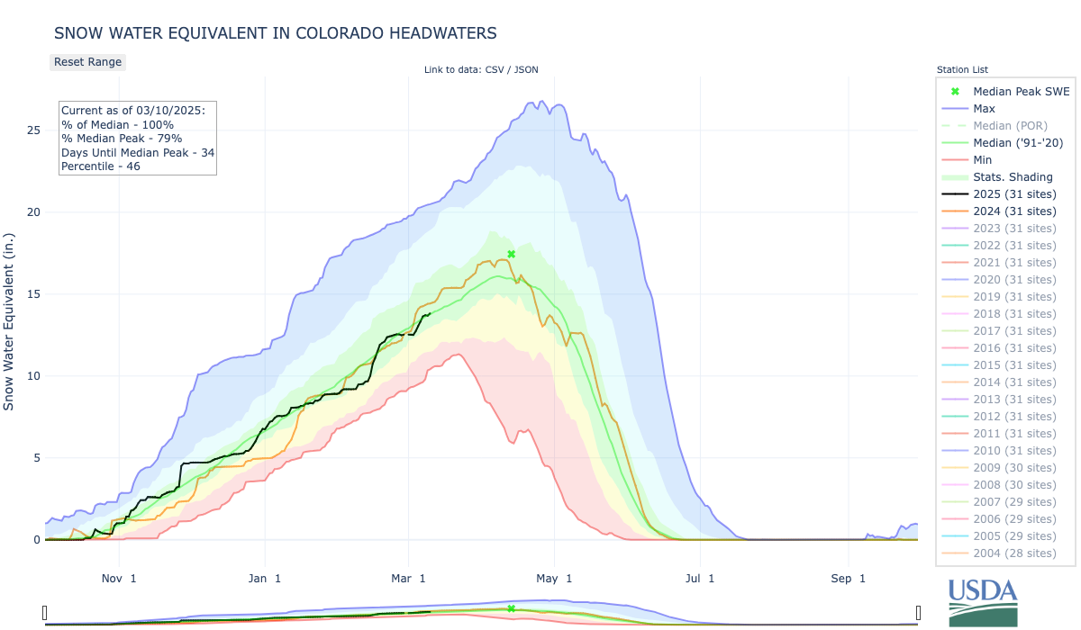
“We can see the snowpack looks like steps on our charts around all these holidays,” Elder said. “With the recent storms, we saw basically an entire month’s worth of snow in seven days.”
Elder said that having the snowpack above 100% heading into March is a good sign for our water supply in the coming year.
“March and April are typically our snowiest months of the year in Colorado. Those two months usually provide about one-third of our annual snowpack. That’s because the snow that falls in those months has a higher water content than snow that falls in the beginning and middle of winter,” he said.
Denver Water’s total reservoir supply stands at 82% full as of Feb. 21, which is about average for this time of year. Remember that reservoir levels fall over the winter and then go back up in the spring when the snow melts.
As for what to expect for the rest of the ski season, maybe consider heading to the hills on St. Patrick’s Day or Easter, and who knows possibly even Mother’s Day in May!

Click the link to read the release on the NRCS website:
March 7, 2025
Northern basins have received more moisture than the south. Early season storms bolstered water year to date precipitation in southern basins but a drier mid-winter has tempered forecasts. Higher latitude basins continue to benefit, with streamflow projections near or above median.
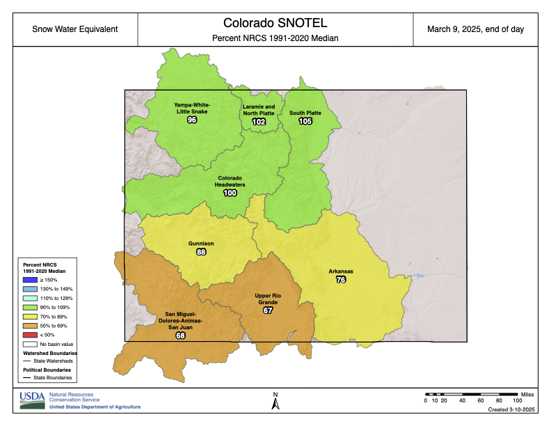
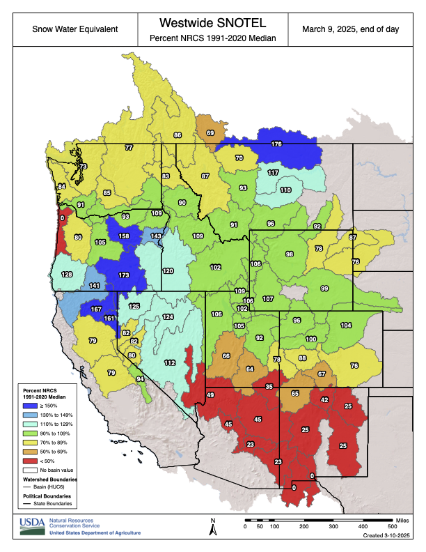
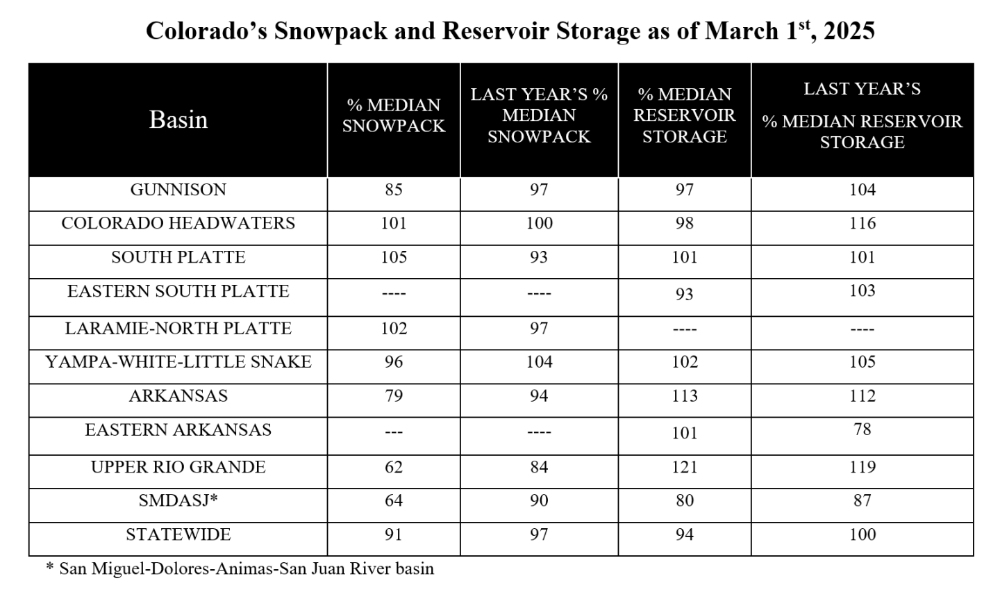
As of March 1st statewide snow water equivalent (SWE) is at 91 percent of median, relatively consistent from February 1st. Northern water systems continue to trend near or above median, particularly: the South Platte (105%), Laramie and North Platte (102%), the Colorado Headwaters (100%) and combined Yampa-White-Little Snake (96%). The southern half of the state remains below normal with the largest decrease observed in the Arkansas (79%). The Gunnison basin is at 86 percent of median, reflective of its central geographical location on the western slope. While the Gunnison basin follows the broader north south trend, its position further north compared to other southern basins has helped mitigate more extreme deficits. In contrast, the Upper Rio Grande (63%) and the combined San Miguel-Dolores-Animas-San Juan (SMDASJ) (64%) remain drier, with some of the lowest snowpack levels recorded at this point in the season.
February storms provided some relief, with the Valentines Day storm delivering up to 3.2 inches of SWE in the La Plata Mountains, offering a much needed boost for the SMDASJ basin. “That said, February’s inconsistent storm cycle has not been game changer. While northern basins benefitted the most, that mid-month surge helped slow the freefall in the southern half of the state but wasn’t quite enough to significantly impact overall snowpack conditions,” noted Nagam Gill, NRCS Hydrologist.
Recent precipitation trends over the past 90 days highlight similar disparities. The Upper Rio Grande and SMDASJ are at just 44 percent of their period of record median precipitation. Northern basins, on the other hand, are sitting in a much better position heading into the peak snowmelt period. The past 30 days show precipitation at 66 percent for the Arkansas basin and 84 percent for the Gunnison basin. Winter precipitation contributes to both snowpack and overall water year precipitation. Snowpack acts as a natural reservoir, storing water at high elevations until melt out, which directly influence streamflow forecasts. While additional precipitation is expected during the summer months, particularly in southern basins during monsoon season the odds of winter driven streamflow fully catching up remain low.
Statewide reservoir storage sits at 94 percent of median, down slightly from 100 percent this time last year. With spring runoff yet to begin, storage levels are mostly unchanged from last month. Higher capacity reservoirs are generally near historical medians. While McPhee Reservoir is lower at 76 percent of median and at 55 percent capacity most major reservoirs are near to above normal and positioned to potentially further exceed medians during primary runoff. Blue Mesa Reservoir is at 96 percent of median and at 61 percent capacity. Pueblo Reservoir is at 114 percent of median and at 72 percent capacity. Lake Granby is at 101 percent of median and Dillon reservoir is at 91 percent of median.
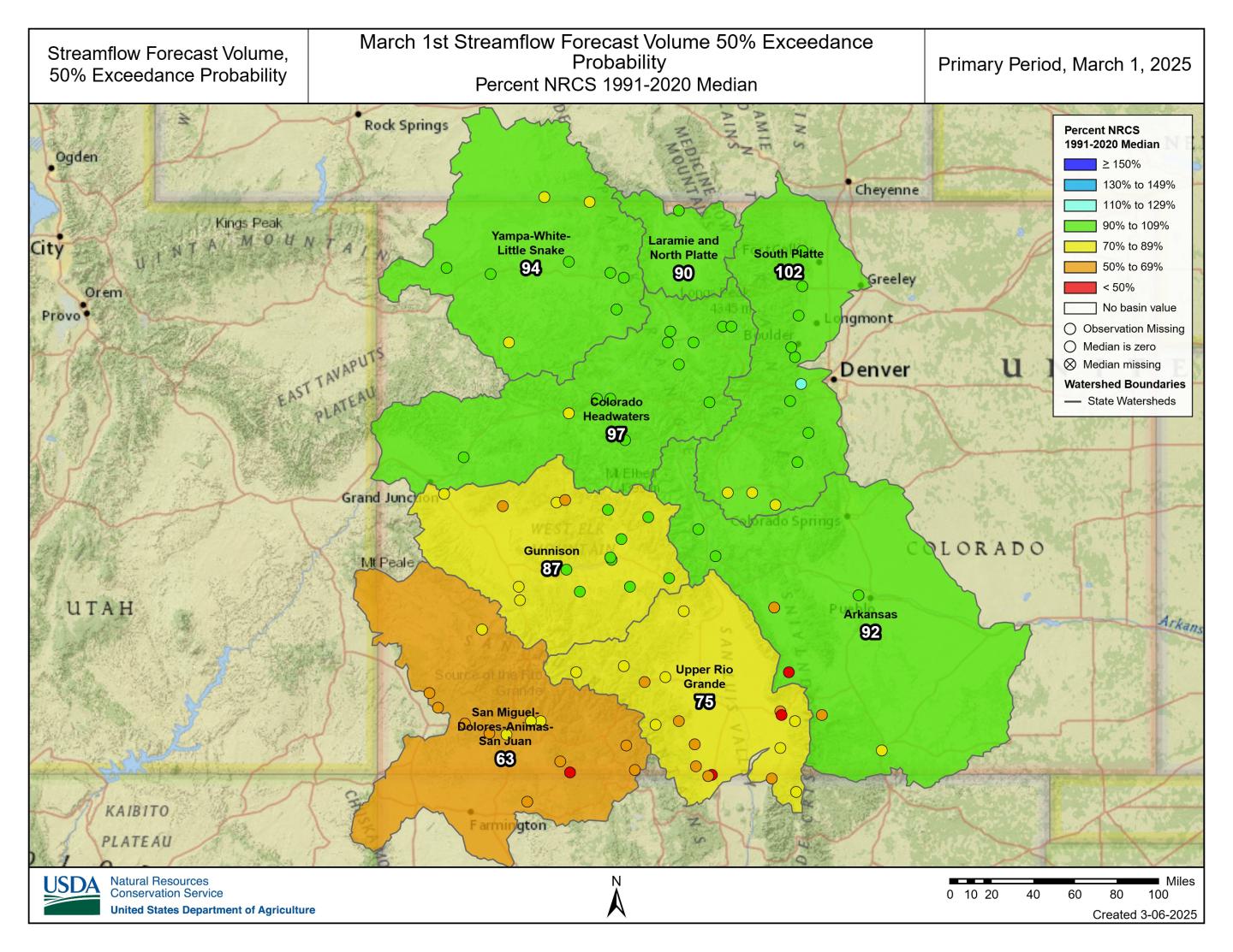
Streamflow forecasts for March 1st closely reflect recent precipitation and snowpack trends. Statewide, the 50% exceedance streamflow remains largely unchanged from last month, currently at 88 percent of median. Of the 86 forecasts points, nearly half are projected to perform at or above 85% of median streamflow. Northern basins, which have benefited from stronger storms, continue to see near median or above median streamflow projections at the 50% exceedance probability. Meanwhile, southern basins, particularly the Upper Rio Grande and combined SMDASJ, remain well below normal. “A critical consideration when reviewing these forecasts is the full range of exceedance probabilities. In regions already experiencing sustained dry conditions, the drier exceedance forecasts (70%, 90% or 95%) may be more likely to materialize if current trends persist. Likewise, if the latter part of the season trends wetter, higher probabilities (30%, 10% or 5%) should be taken into account,” notes Gill. The variability of forecasted volumes means that relying solely on the 50% exceedance forecast may not fully capture the uncertainty inherent in these projections.
In the Upper Rio Grande, one of the highest output forecast points, Rio Grande near Del Norte, is forecasted at 380 KAF for the primary period April – September (50% exceedance probability). This is below the median of 480 KAF. If drier conditions continue, the 70% exceedance probability is 320 KAF, highlighting the potential if snowpack conditions persist or in the event of earlier melt out dates.
Following suit in the Arkansas, 50% forecasts have decreased from last month to 92 percent of median. While the 50% probability is slightly below normal there is a potential for streamflow to perform near or below minimum forecasts. Recent discussions suggest that actual streamflow’s in the Arkansas Basin may underperform relative to the NRCS forecast probability suite. NRCS streamflow forecasts are constrained by internal modeling thresholds and do not extend below 95% exceedance probability, meaning that exceptionally dry conditions may not be fully captured within the published forecast range.
Between March 1-7, storms have been delivering snowfall to much of the state with the southwest corner observing up to 2.5 inches of SWE at Red Mountain Pass. NOAA’s 6-10 day forecast outlook suggests increased chances for precipitation statewide, with the western slope showing slightly higher probabilities and the southwest corner expected to receive higher amounts. Temperature trends indicate cooler than average conditions on the western slope, while the central to eastern regions are projected to remain near normal, with the far eastern plains trending slightly warmer. This pattern would help extend snowpack longevity in the northern and central mountains while also offering a potential boost to moisture starved southern basins. Statewide, peak SWE is typically around April 8, meaning we still have a few weeks left to accumulate more snow.
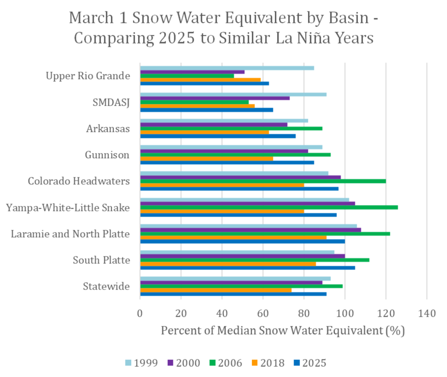
To put 2025’s snowpack in perspective, the above graph compares March 1 snow water equivalent (SWE) percentages to similar La Niña years, including 1999, 2000, 2006 and 2018. Historically, La niña conditions favor increased snowfall in northern Colorado while the southern basins often experience drier conditions. This trend holds in 2025, with the Upper Rio Grande and SMDASJ tracking close to 2018 levels, a year that observed similar dry patterns. Meanwhile, statewide SWE trends resemble 2000.
For more details see the March 1st Water Supply Outlook Report.