Charting mountain #snowpack: Remote snow-monitoring sites provide critical data about our water supply — Jay Adams (DenverWater.org)

Westwide SNOTEL basin-filled map February 28, 2025.

Click the link to read the article on the DenverWater.org website (Jay Adams):

February 21, 2025

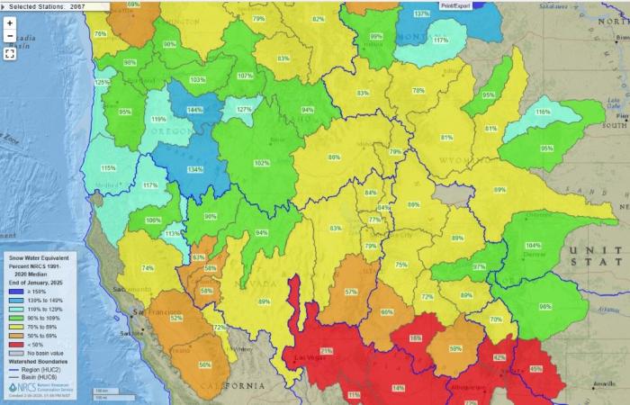
Chances are when you’ve watched your favorite weather person on the local news you may have seen them put up a map of Colorado that shows the statewide snowpack.

If you’re a curious person you may wonder: Why do they show the map? What is snowpack? And where do they get all that information?

We’re here to help answer these questions. 

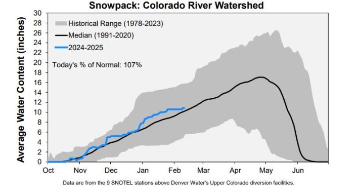
First off, snowpack is the amount of water stored in the snow that blankets the mountains across our state. It’s important to measure the snowpack because the snow is where Colorado gets about 80% of its water supply for household and agricultural uses.

So now to answer the final question: Where does information about the snowpack come from? The data comes from SNOTELs. 

OK, so what’s a SNOTEL?

Well, SNOTEL is short for “snow telemetry.” Think of it as just a fancy way of describing an automated weather station in a remote location that beams information back to a database.

9News meteorologist Cory Reppenhagen talks about the statewide snowpack during an evening weathercast. Image credit: 9News.

“In Colorado, we have 117 SNOTEL sites, and there are over 900 sites across 13 western states,” said Brian Domonkos, a hydrologist with the U.S. Department of Agriculture’s Natural Resources Conservation Service. “These sites have been around since the late 1970s and provide critical information about the amount of water in the snowpack.”

SNOTELs use “snow pillows” to measure the water content. 

Snow pillows are rubber bladders on the ground that are filled with water and ethanol (to prevent the water from freezing). The pillow then weighs the snow, like when you stand on a scale to get your weight.

This SNOTEL site is located on the top of Berthoud Pass in Grand County. The snow pillow is covered in snow in front of the shed. Photo credit: Denver Water.

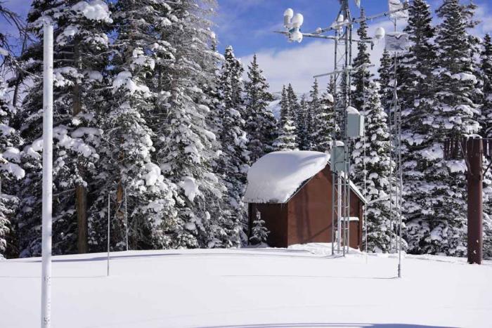
The pressure on the pillow pushes an equal amount of the antifreeze liquid into a measurement tube, which converts the weight of the water contained in the snow into inches of water content. This measurement is the snowpack, which is technically called the Snow Water Equivalent, and also known as SWE. 

A sensor reads the SWE from the tube and sends the data to the NRCS’s central database.

The same SNOTEL site at Berthoud Pass in the summer shows the gray snow pillows located in front of the shed. Photo credit: Natural Resources Conservation Service.

“Generally speaking, here in Colorado, 10 inches of snow melted down equals roughly about 1 inch of water,” Domonkos said. “The data is used to predict how much water will flow into rivers and streams when the snow melts in the spring.” 

The information from the SNOTELs is used by farmers, ranchers, water utilities, environmental groups and recreationists. Communities also use the information to be aware of the potential for flooding during the spring runoff. 

There are 16 SNOTELs in Denver Water’s collection area that are viewed daily by the utility’s water planning team. 

“The SNOTEL network is the most important source of information we have to manage our water supply, and I honestly can’t image how we’d get by without them,” said Nathan Elder, Denver Water’s manager of water supply.

This chart uses SNOTEL data to determine the Snow Water Equivalent in the area of the Colorado River Basin where Denver Water collects its water. Note the left side that shows the inches of water content in the basin. Image credit: Denver Water.
This map shows the 16 SNOTEL sites located in areas where Denver Water collects water for 1.5 million people in the metro area. Image credit: Natural Resources Conservation Service.

Elder’s team uses the data to make informed decisions about reservoir management and whether any water restrictions for Denver Water customers may be needed in addition to the regular summer watering rules

Denver Water also monitors 115 SNOTEL sites upstream of Lake Powell to keep an eye on conditions in the Upper Colorado River Basin. Denver Water collects half of its water supply from rivers and streams that feed into the Colorado River.

“We use the SNOTEL data to provide insight into potential water rights calls that may impact our operations,” Elder said. “The earlier we have information, the better decisions we can make with our water supply.”

Denver Water also relies on manual snowpack readings collected on snow courses and from data collected in the spring from an Airborne Snow Observatory. Learn about these methods in this TAP story.

This map shows snowpack information collected from SNOTEL sites in river basins across the western U.S. Image credit: National Resources Conservation Service.

Domonkos said the SNOTELs are also critical in monitoring long-term weather trends across the western U.S. 

“When you’re watching the news, you’ll see the various river basins showing a certain percent of the normal amount of snowpack for that date,” Domonkos said. “We always like to see the snowpack in the 100% to 120% range so it’s not too high that could lead to flooding and not too low that could lead to water shortages.”

Along with measuring the snowpack, the SNOTEL sites also measure all other forms of precipitation like rain, hail and ice. They also measure air temperature, soil moisture and soil temperature.

Brian Domonkos checks out weather data at the Berthoud Pass SNOTEL site in Grand County. Photo credit: Denver Water.

“These sites are very important for not only day-to-day weather information, but also for comparing snowpack year to year so we can keep track of any emerging trends,” Domonkos said.

All of the information is available for free on the NRCS website, which has a variety of data from each SNOTEL site. The information can be found on the NRCS website.

Denver Water’s entire collection system. Image credit: Denver Water.

With #Utah water deal in place, Navajo Nation urges Congress to pass #Arizona deal — AZCentral.com #ColoradoRiver #COriver #aridification

Click the link to read the article on the AZCentral.com website (Arlyssa D. Becenti). Here’s an excerpt:

February 29.. 2025

Key Points

  • Navajo Nation officials met with Utah leaders to sign a final decree in their long-awaited Colorado River water settlement.
  • The Utah agreement will deliver clean running water to thousands of people in southeastern Utah, where many homes lack such basic services.
  • Arizona’s agreement with the Navajo Nation was sent last year to Congress, where it failed to receive a vote. Leaders are working to reintroduce it in the new Congress.

Navajo Nation Delegate Shaandiin Parrish said that after Utah signed the decree formalizing the Navajo Utah Water Rights Settlement — allocating 81,500 acre-feet of water per year to the Navajo Nation in Utah — work can begin on delivering clean running water to thousands of people who have long needed it…Navajo officials now turn their attention to Congress, where their Colorado River settlement with Arizona awaits action. The agreement was left behind last year.

Joel Ferry, executive director of the Utah Deparment of Natural Resources, Utah Lt. Gov. Deidre Henderson , Navajo Nation Delegate Shaandin Parrish and Navajo Chief Legislative Counsel Michelle Espino, after Utah and Navajo Nation signed a water agreement. Provided by the Navajo Nation Council

The Southeastern Colorado River General Adjudication, which affirmed the Navajo Nation’s water rights in Utah, began in 1988. Negotiations for the Navajo Utah Water Rights Settlement Act between the Navajo Nation and Utah started in 2003 and were finalized in 2015, two years after the Interior secretary appointed a federal negotiation team to join the discussions…In 2022, the Navajo Nation, Utah and the federal government officially signed the agreement, after which Utah moved forward with adjudication, ultimately leading to the issuance of the decree.

“The adjudication is a key component of the Utah-Navajo Nation Water Rights Settlement, which secures the Nation’s rights to both surface and groundwater from the Colorado River within Utah,” according to the Navajo Nation Council. “The settlement also includes significant funding provisions for water infrastructure development, the Navajo Water Development Trust Fund, and the Navajo Operation, Maintenance, and Replacement Trust Fund.”

[…]

Within the Navajo Utah Water Rights Settlement, $210.4 million was authorized for water infrastructure development:

  • $11.1 million for the Navajo Operation, Maintenance and Replacement Trust Fund
  • $1 million for implementing the act
  • $198.3 million for the Navajo Water Development Trust Fund

The Pagosa Area Water and Sanitation District sets fees for 2025 — The #PagosaSprings Sun

The water treatment process

Click the link to read the article on the Pagosa Springs Sun website (Josh Pike). Here’s an excerpt:

February 26, 2025

At its Feb. 13 meeting, the Pagosa Area Water and Sanitation District (PAWSD) Board of Directors approved increases in rates and other fees for 2025. The increases include a 3 percent increase on water rates and fill station charges and a 10 percent increase on wastewater rates, with wastewater availability of service and wastewater hauler charges rising by 30 percent.

The monthly service charge for water increased from $32.38 to $33.35 with the volume charge per 1,000 gallons growing from $5.81 to $5.98 for 2,001 to 8,000 gallons of usage, from $11.63 to $11.98 for 8,001 to 20,000 gallons of usage and from $14.60 to $15.04 for more than 20,001 gallons of usage. Water fill station charges per 1,000 gallons rose from $12.55 to $12.93, and water availability of service fees increased from $14.73 to $15.17.

Monthly service charges for wastewater increased from $42.64 per equivalent unit (EU) to $46.90 per EU while the short-term rental monthly service charge rose from $59.70 to $65.66. Wastewater availability of service fees increased from $16.25 to $21.13 per month, and wastewater hauler charges per 100 gallons of waste rose from $17.26 to $22.44. Water and wastewater capital investment fees also increased by 3 percent, taking the water capital investment fee from $8,958 to $9,227 and the wastewater capital investment fee from $15,697 to $16,168…Although not noted by Burns, the fee changes also include an increase of water equity buy-in fees from $4,323 to $4,706 and a decrease in wastewater equity buy-in fees from $3,425 to $3,372.

Wastewater Treatment Process