
Click the link to read the report on the NOAA website:
March 6, 2025
Key Points
- Another month of extremely dry conditions plagued the Southwest (Colorado, New Mexico, Arizona, Utah, Nevada), leading to deepening snow deficits across already dry basins. Exceptional snow drought continues to persist with the peak snow water equivalent (SWE) dates past for Arizona and New Mexico.
- Lower-elevation snow drought persisted across southern Alaska due to continued warm and dry conditions, with Anchorage Airport recording its driest February on record. Large areas in southwest Alaska and low elevations in south-central Alaska—which are typically snow covered—were (nearly) snow-free as of March 1.
- Moderate snow drought conditions persisted in the northern and central Cascade Range of Washington due to below-average winter precipitation.
- A recent storm cycle brought welcome moisture back to California and Nevada, improving snow drought conditions, but deficits still remain in the region.
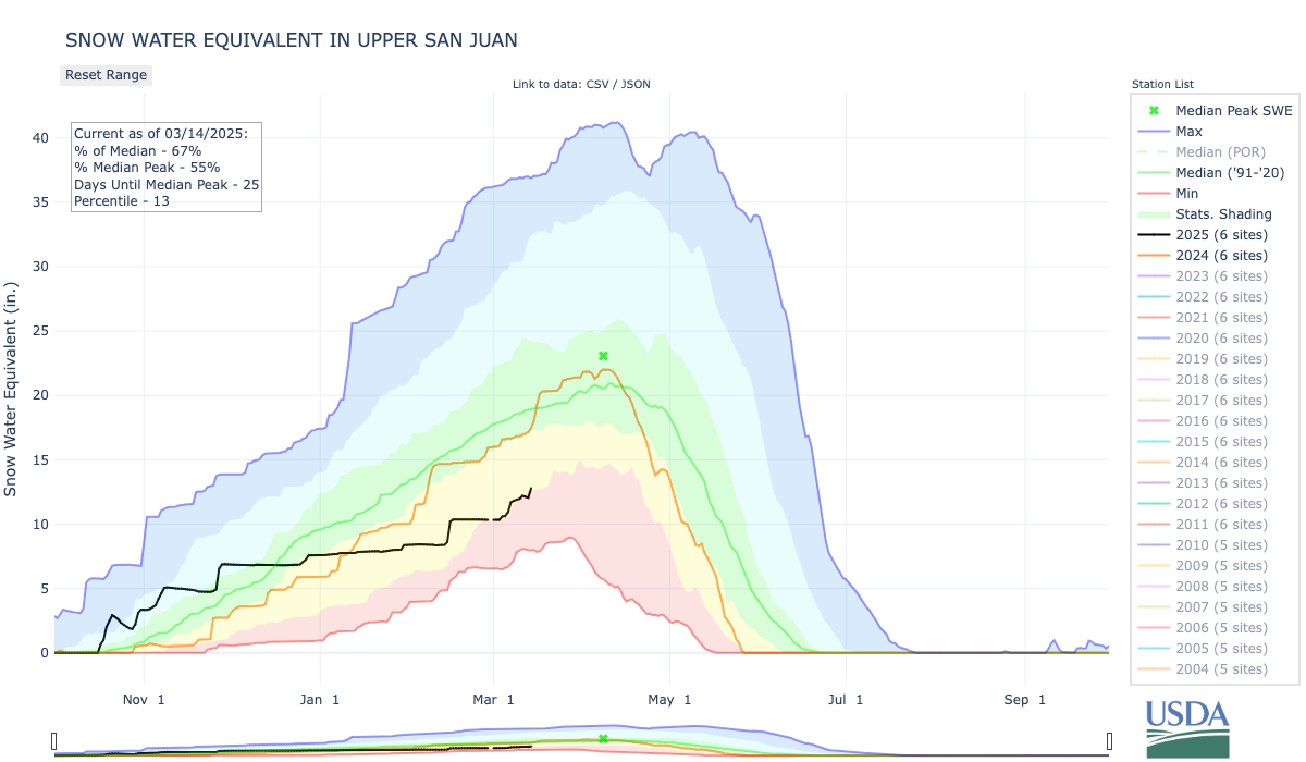
- The Upper San Juan, Upper Rio Grande, and Gunnison River Basins provide substantial snowmelt and runoff to the Upper Colorado River Basin, which drains into Lake Powell. Given low snowpack in these basins, monitoring snow conditions will be critical for future water supply as the basins enter the spring snowmelt season.
- The National Weather Service Climate Prediction Center’s outlooks favor a likely colder and wetter pattern over the next month in the West, which could be favorable for snow accumulation.
Snow Drought Conditions Summary
This update is based on data available as of Monday, March 3, 2025 at 12:00 a.m. PT. We acknowledge that conditions are evolving.
Current Conditions
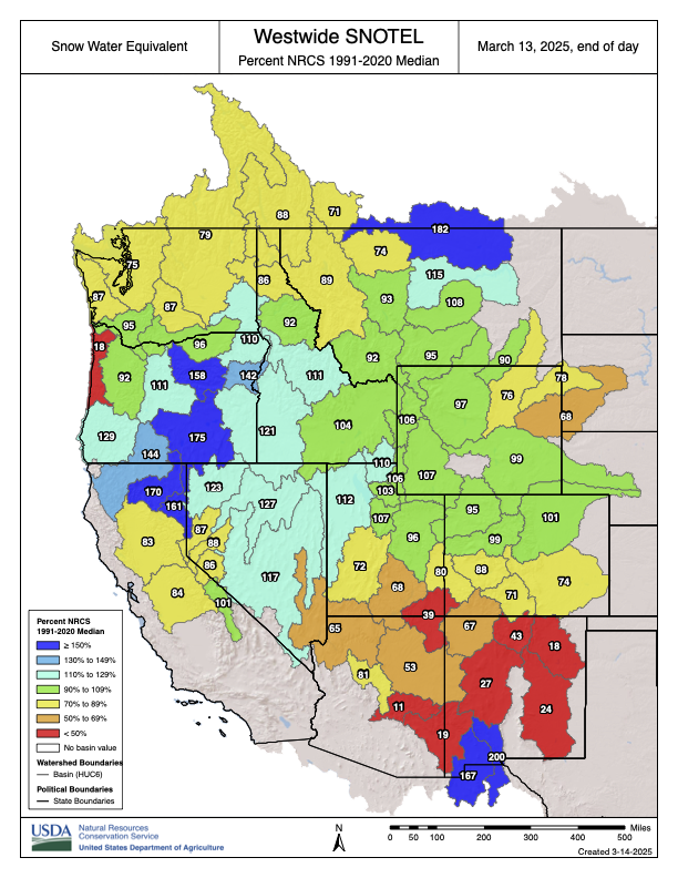
Extremely dry conditions across the West in January transitioned to a more active precipitation pattern in February improving the snowpack for much of the West, particularly in the Sierra Nevada, northern Great Basin, and northern Rocky Mountains. In contrast, much of the southern Rocky Mountains, Arizona, and New Mexico saw very little snowfall over the past month. The worst snow drought conditions continue to be in the Southwest, including southern Utah, southwestern Colorado, Arizona, and New Mexico. Snow drought conditions also persist in the northern and central Cascade Range of Washington.
Looking Ahead
The U.S. Bureau of Reclamation weekly water supply report for the Lower Colorado River Basin predicts unregulated inflows into Lake Powell will be 70% of normal in April–July. This is despite 92% of normal snow water equivalent (SWE) in the Upper Colorado Basin, as Colorado river tributary watersheds across central Utah (the San Juan River Basin, the Green Basin, and Gunnison Basin) saw below-normal precipitation and persistent low soil moisture conditions. Spring storms could help boost snowpack, but erasing the deep seasonal deficits across these basins is unlikely.
Throughout Arizona and New Mexico, above-normal potential for significant wildfires persists through June, according to the National Interagency Fire Center. Wildfire season generally begins earlier and peaks later in these states compared to other areas of the West due to earlier peak SWE and a climatologically dry spring before the monsoon season begins.
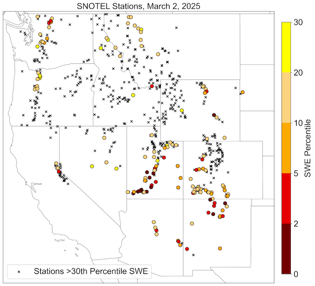
Several Western U.S. Stations Have SWE Below the 30th Percentile
Rocky Mountain Snow Conditions (Colorado, Idaho, Montana, Utah, Wyoming)
Northern Rockies
Snowpack has generally improved in the northern Rocky Mountains over the past month, with most hydrologic unit code (HUC) 6 basins reporting near- to above-normal snow water equivalent (SWE). However, the Marias and Upper South Saskatchewan Basins in northwestern Montana are still in snow drought, with SWE at 71% and 73% of normal, respectively. Precipitation over most of the Bighorn Mountains in north-central Wyoming was well below normal over the past month, particularly the southern part of the range. Snow drought conditions are present in the central and southern part of the Bighorn Mountains, where SNOTEL stations are reporting 48–92% of normal SWE.
Central Rockies
Snow drought conditions have persisted and, in some cases, intensified across central and southern Utah and southwestern Colorado. Thirteen SNOTEL stations scattered across south-central and southwest Utah report record-low snow water equivalent (SWE). The Lower Colorado-Lake Mead, Escalante Desert-Sevier Lake, and Upper Colorado-Dirty Devil Basins have 29%, 51%, and 56% of normal SWE, respectively. This is the lowest SWE on record for the Lower Colorado-Lake Mead Basin for this date. The Lower Green Basin, including the south slopes of the Uinta Mountains in northeastern Utah, report 79% of normal SWE.
SNOTEL stations in southwestern Colorado, including stations in the San Juan and Sangre de Cristo mountains, also report snow drought conditions, with most locations below the 20th percentile SWE. Northwestern portions of the Gunnison Basin also have well-below-normal snowpack. The Upper San Juan, Rio Grande Headwaters, and Gunnison Basins are at 56%, 62%, and 82% of normal SWE, respectively. These basins provide substantial snowmelt and runoff to the Upper Colorado River Basin, which drains into Lake Powell. It will be critical to watch snowpack in these basins heading into the spring snowmelt season. February temperatures were 4–6 °F above normal in much of southern Utah and western Colorado, helping drive snow drought across the region.
Low Snow Water Equivalent in Upper San Juan River Basin
Arizona and New Mexico Snow Conditions
Snow drought conditions remain severe as much of the region is nearing or has passed the dates at which snow water equivalent (SWE) typically peaks for the year. In Arizona and parts of New Mexico, peak SWE typically occurs around March 1, much earlier than most of the mountains in the West. The trend of persistent above-normal temperatures and lack of snowfall continued in February in the mountains across the region.
All but two SNOTEL stations in Arizona and New Mexico report less than 50% of normal SWE, with no snow at some locations. In Arizona, the Verde Basin, which has a median peak SWE date of March 1, is currently at 8% of median peak SWE, and the Little Colorado Basin, which has a median peak SWE date of March 4, is currently at 17% of median peak SWE. In New Mexico, the Upper Rio Grande and Upper Canadian Basins are at 39% and 28% of normal SWE, respectively.
Initial surges of spring snowmelt already occurred at some locations in the Upper Canadian Basin, which is several weeks earlier than normal. February temperatures were 4–6 °F above normal across much of the region, which contributed to increased snowmelt at lower elevations.