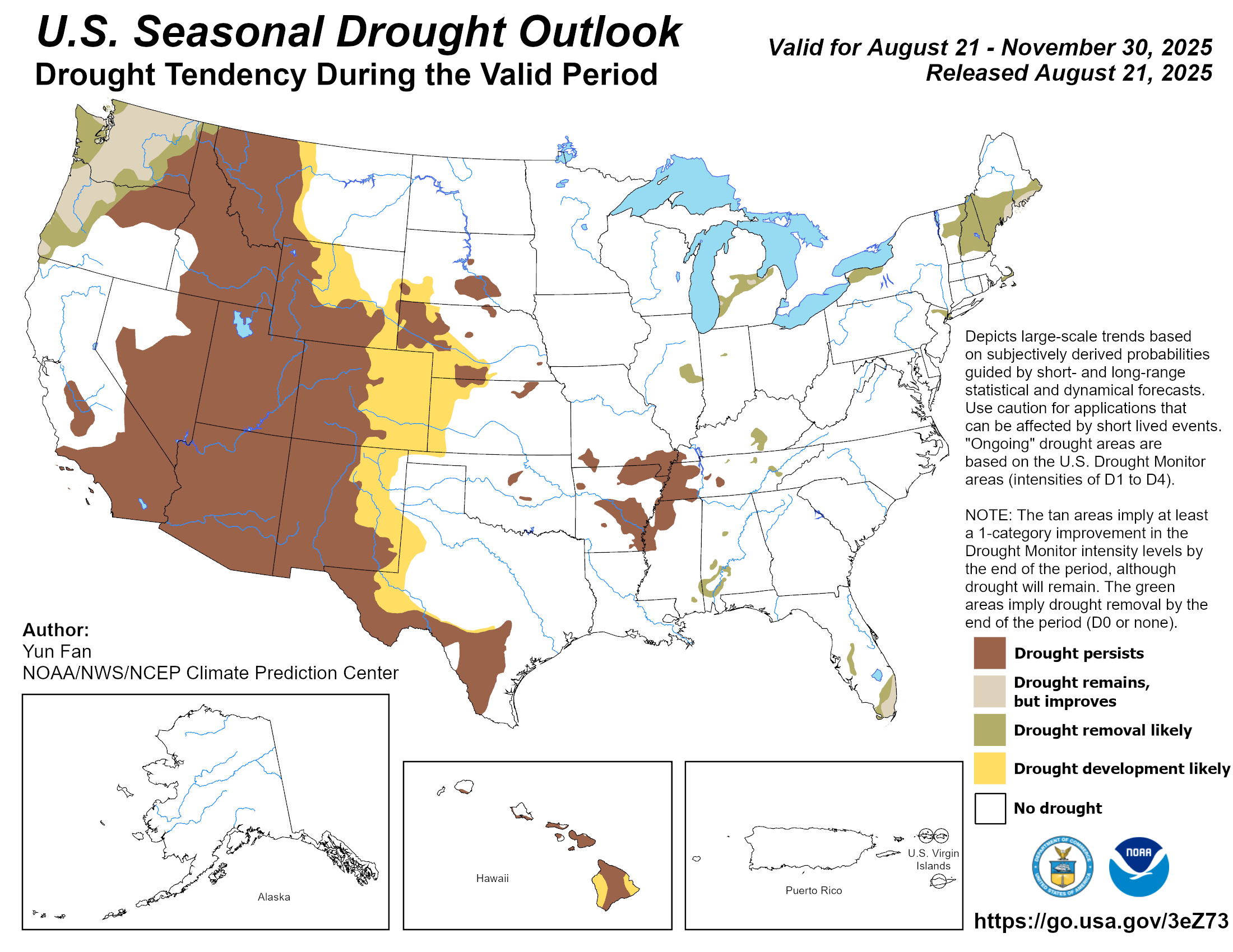
Between Aug. 13–19, 2025, dry and drought conditions were widespread, driven by hotter-than-average temperatures and below normal precipitation across much of the country. Temperatures across the country were mostly 1 to 5 degrees above normal, while isolated areas of North Dakota, Minnesota and California saw below-normal temperatures. Areas in the central High Plains and Midwest, Arkansas, along the Ohio River, central Pennsylvania and New York saw temperatures of 5 to 10 degrees above normal. Precipitation was mostly near to slightly below normal for much of the country. Along the Pacific Northwest coastline, rainfall was 1 to 3 inches above normal. The Southeast also saw areas of 1 to 3 inches above normal precipitation where thunderstorms dropped heavy precipitation. A series of storms brought above normal rainfall from South Dakota to Lake Michigan, with areas of eastern South Dakota, southern Minnesota and northeastern Illinois recording 2 to 5 inches. Storms that brought decent moisture saw improvements across the northern Intermountain West, central High Plains and the western Great Lakes region. In the West, severe to exceptional drought (D2–D4) remained widespread across California, Nevada, Arizona, and New Mexico, while hot, dry weather pushed drought to expand in Oregon, Washington, and Idaho. These conditions also fueled large wildfires, particularly in California and the Southwest, where dry vegetation and gusty winds created dangerous fire behavior. The High Plains also saw abnormal dryness and drought intensify across Nebraska, Kansas, and the Dakotas as above-normal temperatures and limited rainfall added stress to crops and rangeland. A few localized showers, however, offered minor improvements. In the South, scattered storms brought limited relief to parts of Texas and south-central Tennessee. Along the Tennessee and mid-Mississippi River valleys, flash drought conditions led to widespread intensification and expansion of abnormal dryness (D0) and moderate drought (D1)—particularly in southern Missouri, western Kentucky and Tennessee, northwestern Mississippi and Arkansas. Areas of the Midwest that received heavy rains saw steady or improved conditions in Minnesota, Wisconsin, and Iowa, while continued dryness led to worsening drought in Illinois, Indiana and Ohio. The Southeast saw mostly stable conditions, though moderate drought and abnormally dry areas persisted in Alabama, Georgia, and the Carolinas. Meanwhile, the Northeast continued to dry up, with the expansion of abnormal dryness (D0) and moderate drought (D2) across New England…
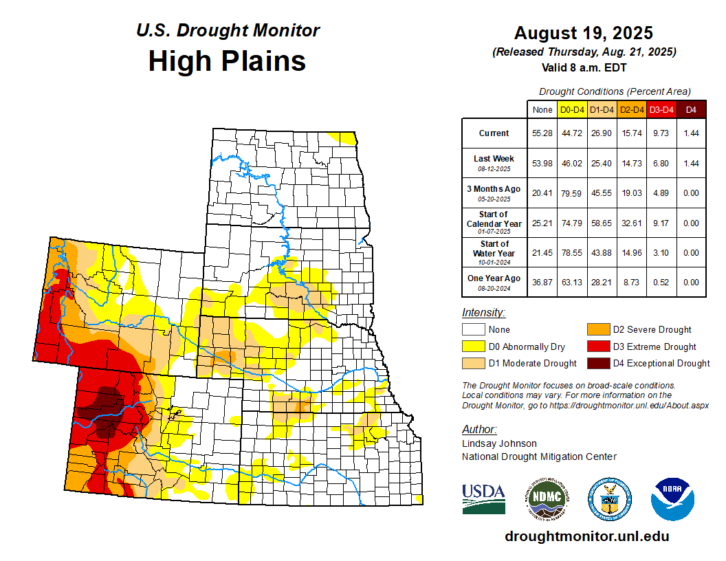
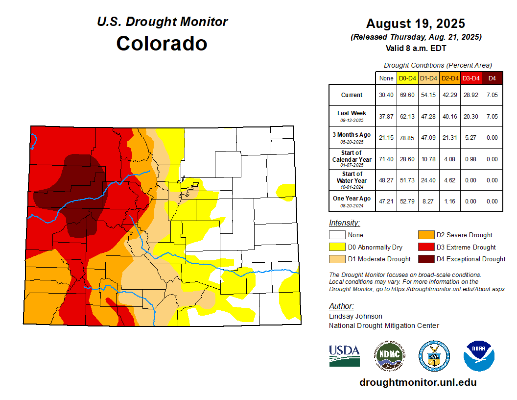
The High Plains saw a mixed pattern of drought changes between Aug. 13–19. North Dakota improved the most, as widespread storms erased nearly all dryness, leaving only a small pocket in the northeast. South Dakota had patchy outcomes, with rainfall trimming drought in some central and southern counties while western areas remained dry. Nebraska also showed contrasts with severe dryness expanding in the Sandhills, especially in Cherry and nearby counties, while parts of the east improved after storms. Kansas slipped slightly drier, with abnormal dryness spreading into the southwest. Conditions were most concerning in Colorado and Wyoming, where persistent heat and limited rainfall drove drought deeper. In Colorado, drought expanded along the Front Range and southwest into northern New Mexico, while Wyoming saw new extreme drought in the northwest and broader expansion of abnormally dry conditions across central counties. These worsening conditions have fueled wildfire activity, most notably Colorado’s Lee Fire, which has already burned more than 137,000 acres, ranking among the state’s largest, while Wyoming has faced smaller but fast-moving rangeland fires…
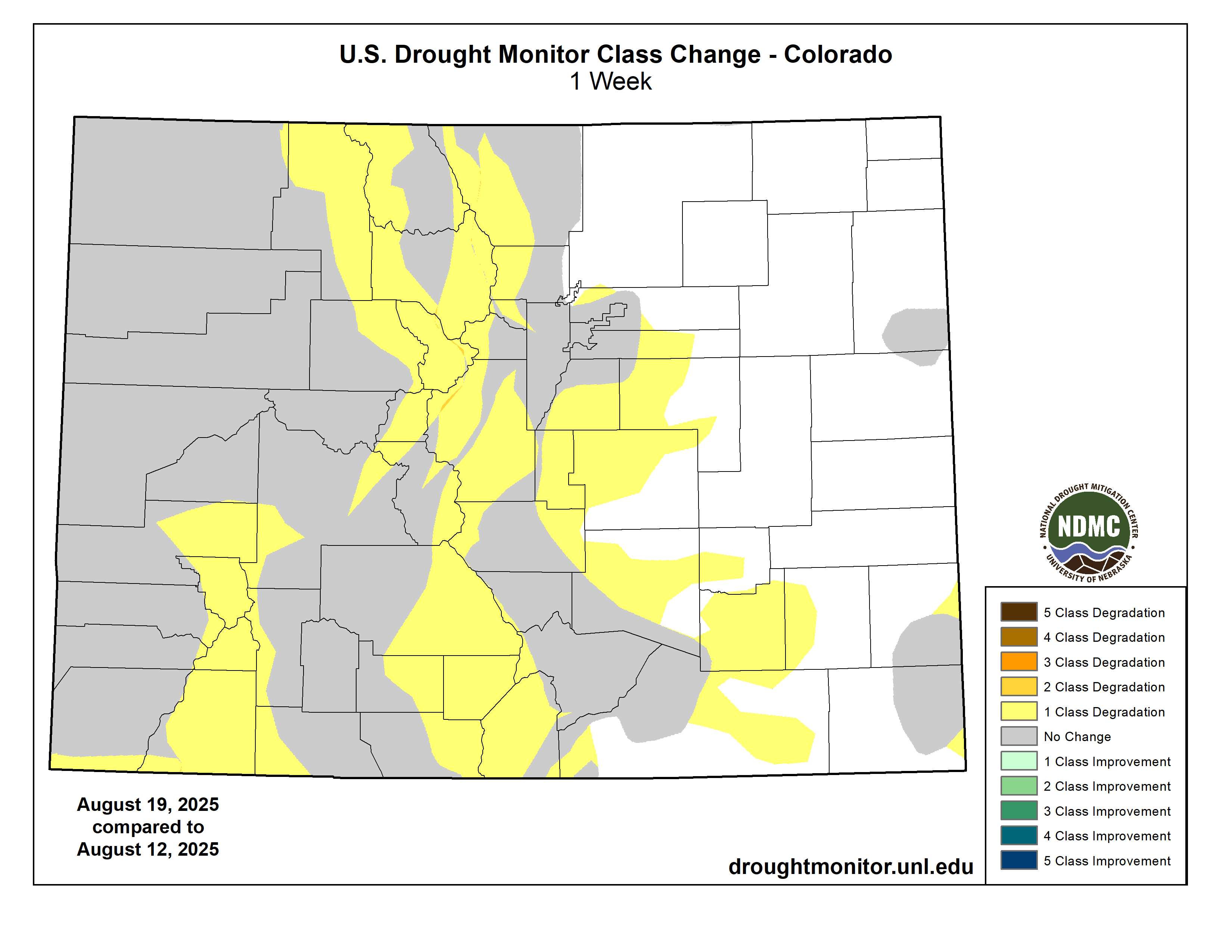
Colorado Drought Monitor one week change map ending August 19, 2025.
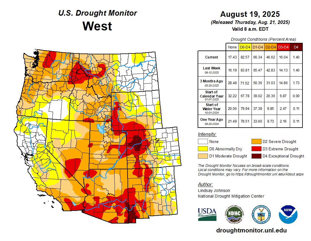
Hot, dry weather dominated much of the West, fueling widespread drought expansion. Arizona and New Mexico saw severe to extreme drought spread north and east as monsoon rains largely missed these areas. In Utah, drought expanded in the south and along the borders of Colorado and Wyoming. Idaho worsened, with severe (D2) and extreme (D3) drought spreading in the southeast and north. Montana was mixed: heavy rains in the northeast allowed drought to ease, but hot, dry weather in the southwest caused drought to intensify. Oregon and Washington saw smaller changes, with some localized improvement in southeast Oregon but worsening conditions in northern Oregon and southern Washington. California remained locked in extreme (D3) to exceptional (D4) drought in the southern regions with no major change. The dry conditions have fed several large wildfires: Arizona’s Dragon Bravo Fire has burned over 145,000 acres and California’s Gifford Fire about 130,000 acres. A record-breaking heat wave, with temperatures above 110°F in desert areas and red-flag warnings across California, has heightened fire danger…
The South saw widespread drought expansion over the week, despite scattered thunderstorms that brought brief, localized relief. Texas saw some improvements due to heavy rains and flooding in south-central counties earlier in the month that continued to ease drought there. Temperatures across the region stayed hot and humid, with heat index values topping 100°F in Texas and Oklahoma. Fire danger also crept higher in Oklahoma and Texas, where persistent heat and dry rangelands created favorable conditions for grassfires. Abnormal dryness (D0) formed in the Panhandle and north-central Texas. There was widespread expansion of abnormal dryness (D0) and moderate drought across much of Oklahoma under hot, windy conditions. Arkansas is experiencing a flash drought with conditions deteriorating quickly, with nearly the entire state now abnormally dry (D0) or worse and pockets of severe drought (D2) developing in the northeast and central counties, along with the expansion of moderate drought (D1). Louisiana also saw abnormal dryness (D0) expand in the northwest and in the southeast and into Mississippi. Mississippi saw moderate drought (D1) expand in both the south and northwest, while Tennessee recorded broad expansion of drought in the west, despite some trimming in the south-central counties. Overall, the South ended the week with worsening drought almost everywhere, reinforcing the strain of prolonged heat and limited rainfall…
Looking Ahead
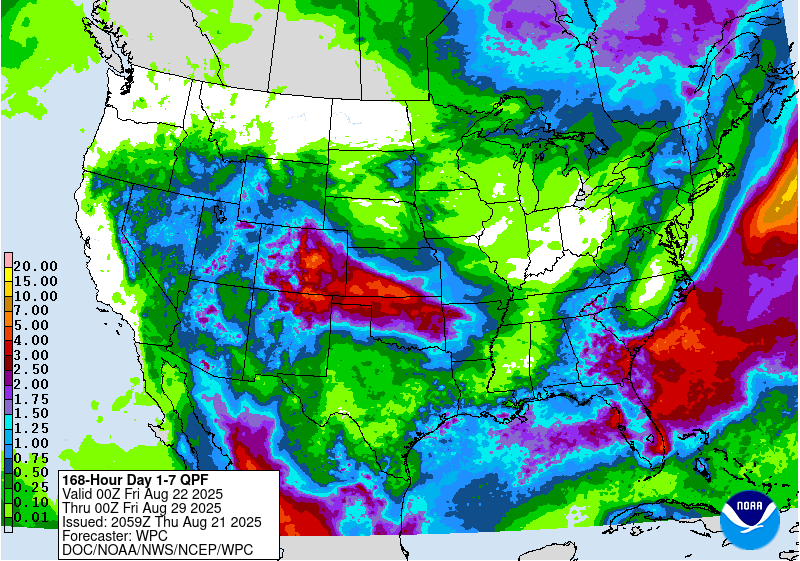
From Aug. 21 to 26, the heaviest precipitation is forecast along the East Coast, especially from North Carolina through the Mid-Atlantic and into southern New England, where amounts may exceed 5 inches, likely tied to a coastal storm system. Pockets of heavier rain are also expected in parts of the central Rockies, High Plains and southern Texas, with localized totals between 2 and 4 inches. Much of the Midwest, Southeast and Southwest are forecast to receive lighter but widespread rainfall, generally between 0.5 and 2 inches. By contrast, the Pacific Northwest and much of California show little to no precipitation expected. Overall, the forecast highlights a wet period for the East Coast and scattered parts of the interior U.S., while the West Coast remains mostly dry.
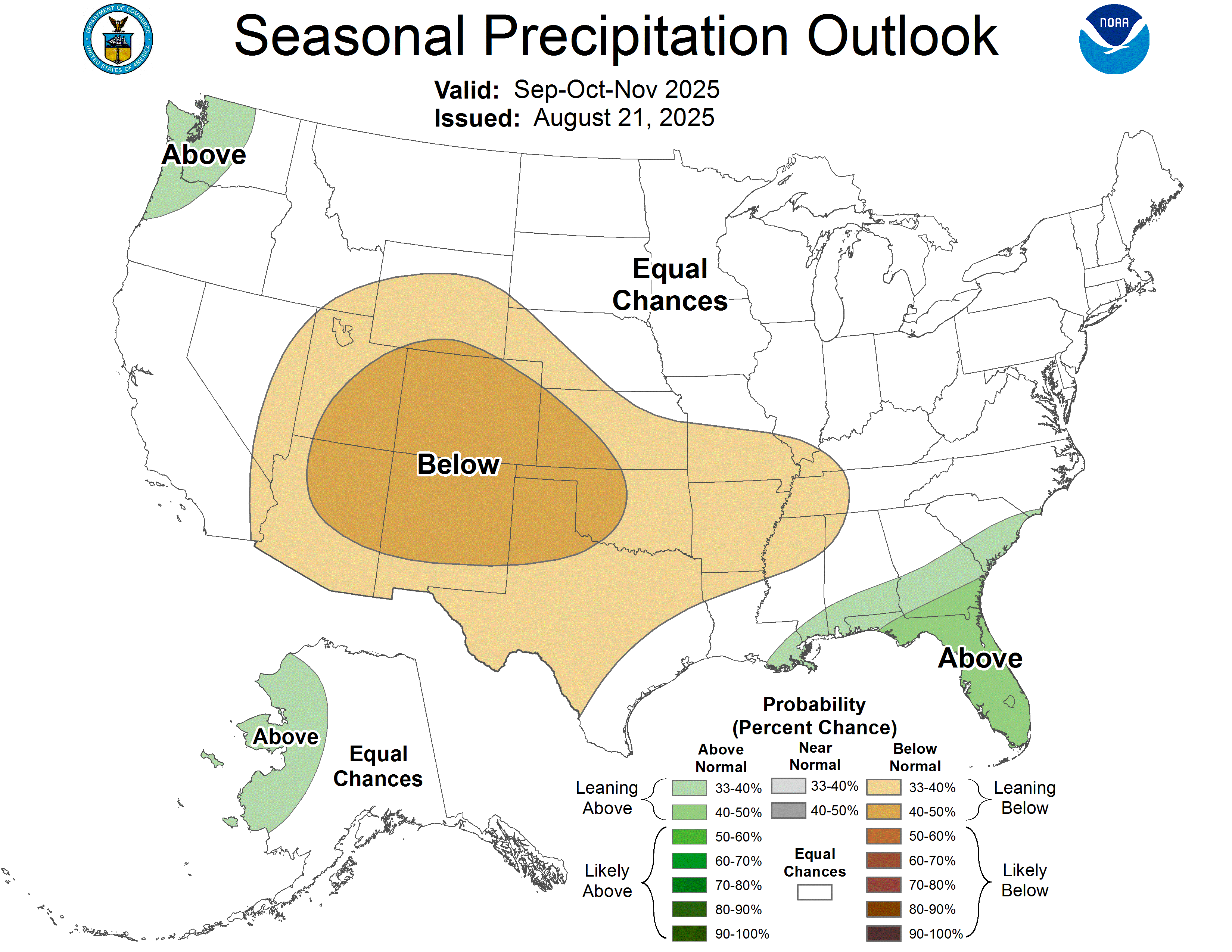
The Climate Prediction Center’s 6-10 day outlook (valid Aug. 26-30) shows much of the central and eastern U.S. is expected to be cooler than normal, with the greatest chance for well-below-average temperatures across the Midwest and Ohio Valley. In contrast, warmer-than-normal conditions are favored along the West Coast, especially in the Pacific Northwest and northern California, as well as in Florida, parts of Alaska and Hawaii. Rainfall patterns show a split across the country: wetter-than-normal conditions are likely in the central and southern Rockies, the Southwest and the central Plains, along with parts of Alaska. Drier-than-normal conditions are forecast for the Great Lakes, Ohio Valley, and portions of the interior Northeast. The Southeast, Gulf Coast and parts of the interior West are generally expected to see near-normal precipitation. Overall, the late-August outlook points to a cool and damp stretch for much of the central U.S., warmer weather along the West Coast and in the far South, and a drier setup in the Great Lakes and Ohio Valley.
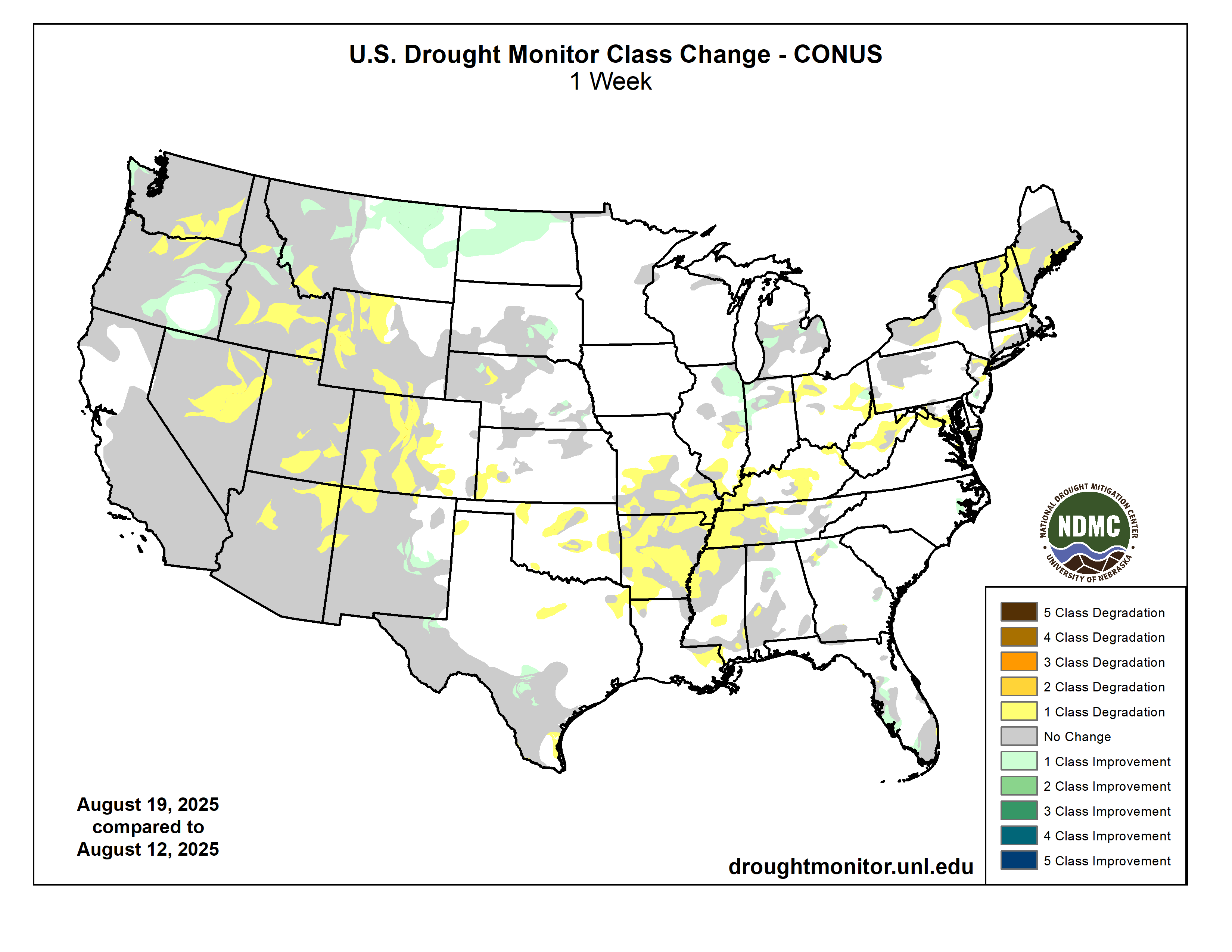
US Drought Monitor one week change map ending August 19, 2025.