
Click the link to read the article on the Pagosa Springs Sun website (Clayton Chaney):
February 26, 2026
A “real” winter storm rolled through Pagosa Country last week, leaving behind 1-2 feet, or more, of fresh snow in spots around the county. Meanwhile, Wolf Creek Ski Area reported nearly 5 feet of new snow, with a total of 59 inches falling from Feb. 17 through Feb. 21. According to reports entered into the Community Collaborative Rain, Hail and Snow (CoCoRaHS) network five-day period ranged from 15.8 inches downtown up to 18.6 inches uptown. The highest totals were seen in the northern part of the county, ranging from 24 inches near Lake Hatcher up to 31.5 inches along the Mineral County border. As of Feb. 25, the ski area reported a year-to-date snowfall of 164 inches with a midway depth of 82 inches and a summit depth of 89 inches…
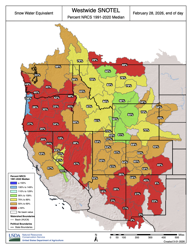
According to the Natural Resources Conservation Services (NRCS), as of Feb. 24, the San Miguel, Dolores, Animas and San Juan River basins were measured to be at 64 percent of its 30-year median snowpack. The statewide snowpack as of Feb. 25 was at 63 percent. A post by Shawn Prochazka from Pagosa Weather notes that the snowpack in the basins jumped from 42 percent to 60 percent during last week’s storm. “That’s an impressive jump this late in the season,” Prochazka writes. As of 11 a.m. on Wednesday, Feb. 25, Wolf Creek Pass, at 10,930 feet, had a snow water equivalent of 14.7 inches. The current amount is 64 percent of that date’s median snow water equivalent…

According to the U.S. Drought Monitor’s most recent map released on Feb. 19, which was valid as of Feb. 17, 100 percent of Archuleta County is in an “abnormally dry” drought stage, with 47.89 percent of the county (the northern half) in a “moderate drought” stage. The far northwestern portion of Archuleta County — 2.17 percent of the county — is in a “severe drought” stage.