Click on a thumbnail graphic to view a gallery of drought data from the US Drought Monitor website.


Click the link to go to the US Drought Monitor website. Here’s an excerpt:
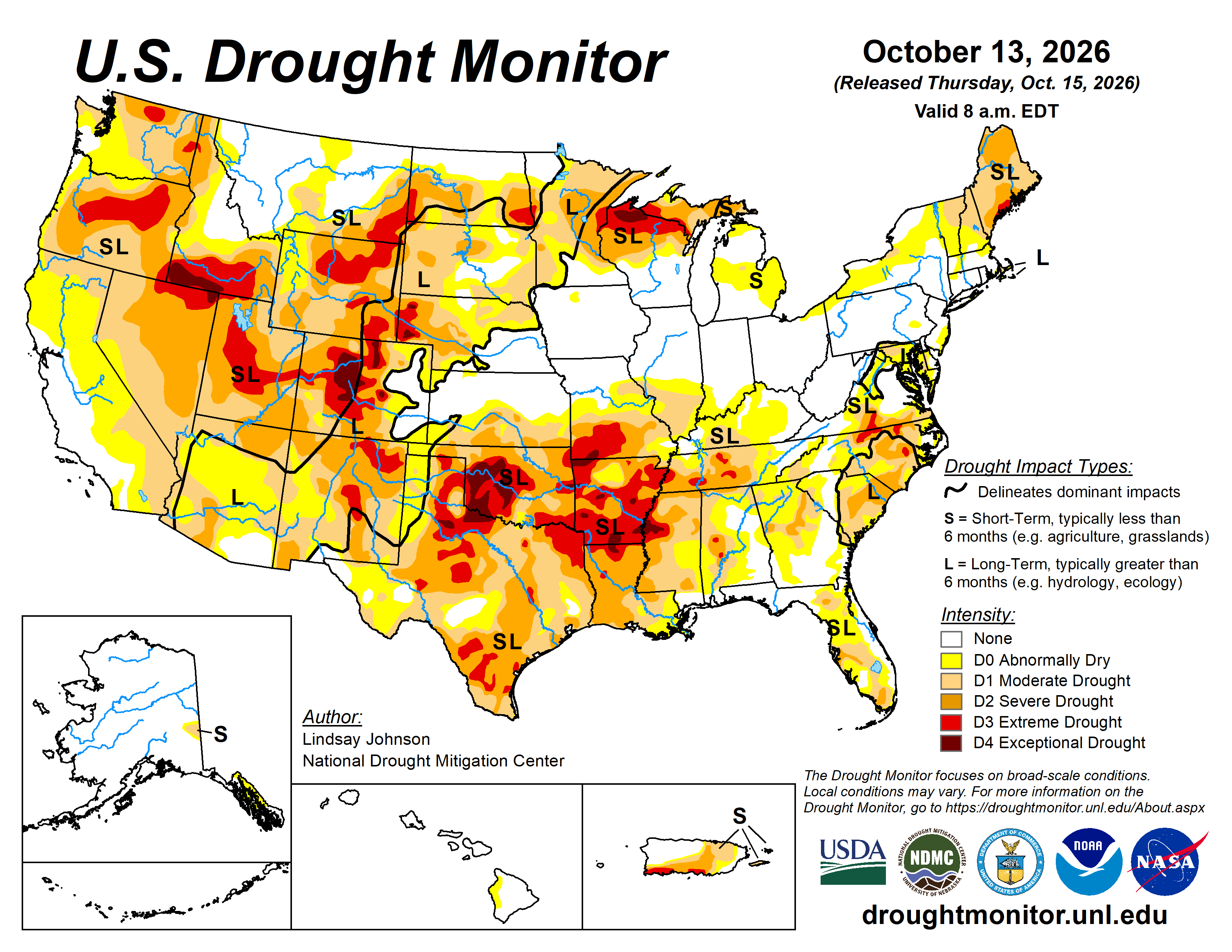
This Week’s Drought Summary
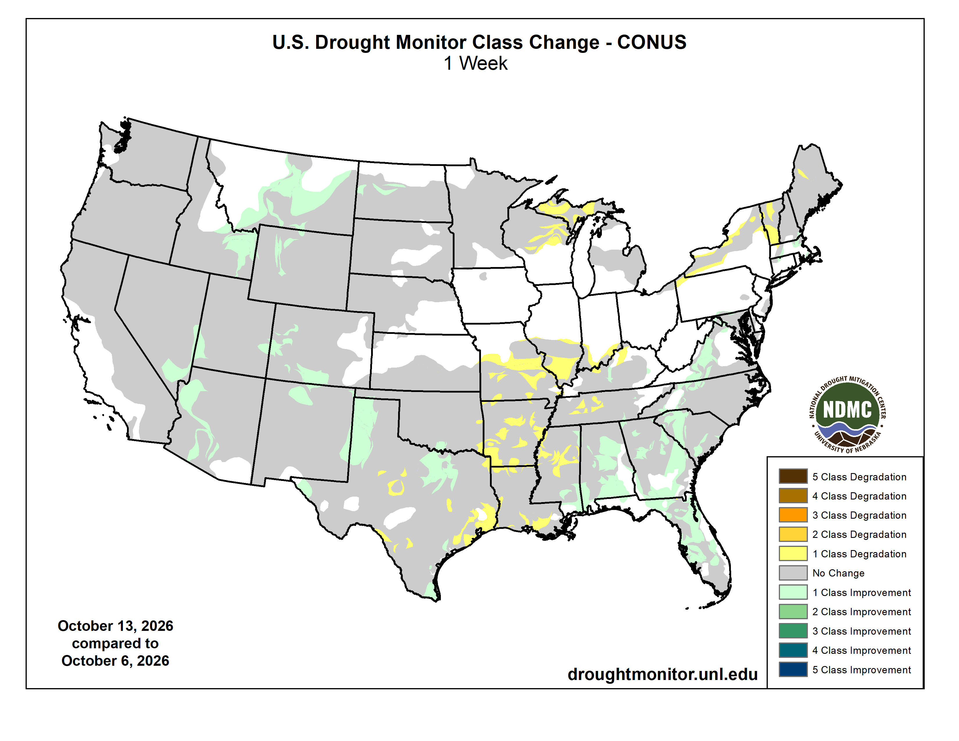
Drought conditions changed considerably across the U.S. this week. Heavy rain and early-season snow brought relief to parts of the West and Southeast, while unusually warm and dry weather continued to worsen drought across portions of the Midwest and South. In the West, a strong storm system combined with moisture from the remains of Hurricane Rachel, bringing rain and mountain snow to parts of the region. Snowfall totals reached 11 inches near Philipsburg, Montana, and nearly 10 inches at Great Falls, Montana, while rain and snow also affected portions of Idaho, Wyoming and Utah. Additional precipitation across the Southwest helped improve drought conditions in parts of Arizona, New Mexico and the Rockies. Despite these improvements, significant drought persisted across portions of the Great Basin and Southwest.
Farther east, temperatures averaged 8 to 16 degrees above normal across portions of the Plains and Midwest. Combined with limited rainfall, the unusual warmth contributed to worsening drought across Wisconsin and the Upper Peninsula of Michigan. A broader area of drought deterioration extended from southern Illinois and Indiana through Missouri and Kentucky into the lower Mississippi Valley and Tennessee. Some of the most significant deteriorations occurred across southwestern Missouri, southern Arkansas and northern Louisiana, where persistent warmth and rainfall deficits continued to intensify drought conditions. In contrast, recent rainfall supported localized improvements across western and northern Texas, including portions of the Texas Panhandle.
The Southeast experienced some of the week’s most widespread improvements as Hurricane Isaias brought heavy rainfall to the region, with totals exceeding 12 inches in parts of the Florida Panhandle and southern Alabama. Although the rainfall caused localized flooding, it also helped ease drought from Virginia through the Carolinas, Georgia, Alabama and Florida, with some locations improving by more than one drought category. In the Northeast, drought changes were mixed and largely depended on where precipitation fell. Areas receiving beneficial rainfall experienced localized improvements, while drought persisted or worsened in locations that missed the heavier precipitation…
High Plains
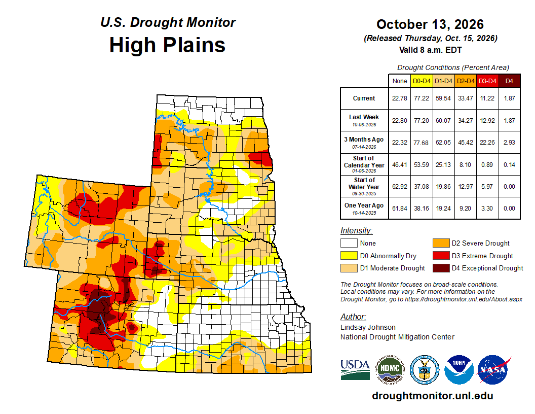
Drought conditions remained largely unchanged across the High Plains, with localized improvements across portions of North Dakota, Wyoming and Colorado and limited deterioration in Kansas. Temperatures averaged 8 to 16 degrees above normal, with locally greater departures. The unusually warm conditions increased evaporative demand and contributed to continued moisture losses, particularly where precipitation was limited. Most of the Dakotas, Nebraska and Kansas received little precipitation during the week, with widespread areas recording less than 25 percent of normal. Localized precipitation occurred across portions of Wyoming and Colorado, but amounts were generally insufficient to produce widespread drought relief.
Localized improvements in North Dakota were supported by precipitation received during the current and preceding weeks, which helped ease short- and mid-term moisture deficits. Elsewhere, drought conditions remained largely unchanged across South Dakota, Nebraska, Kansas and much of the eastern plains of Wyoming and Colorado, where a lack of meaningful precipitation and lingering longer-term deficits supported existing classifications. In Kansas, localized degradations occurred across eastern border with Missouri, where continued dryness and above-normal temperatures contributed to worsening short-term conditions. Despite these changes, significant drought persisted across portions of the western High Plains, particularly in Wyoming and Colorado, where longer-term precipitation deficits and soil moisture shortages continued to limit recovery…
West
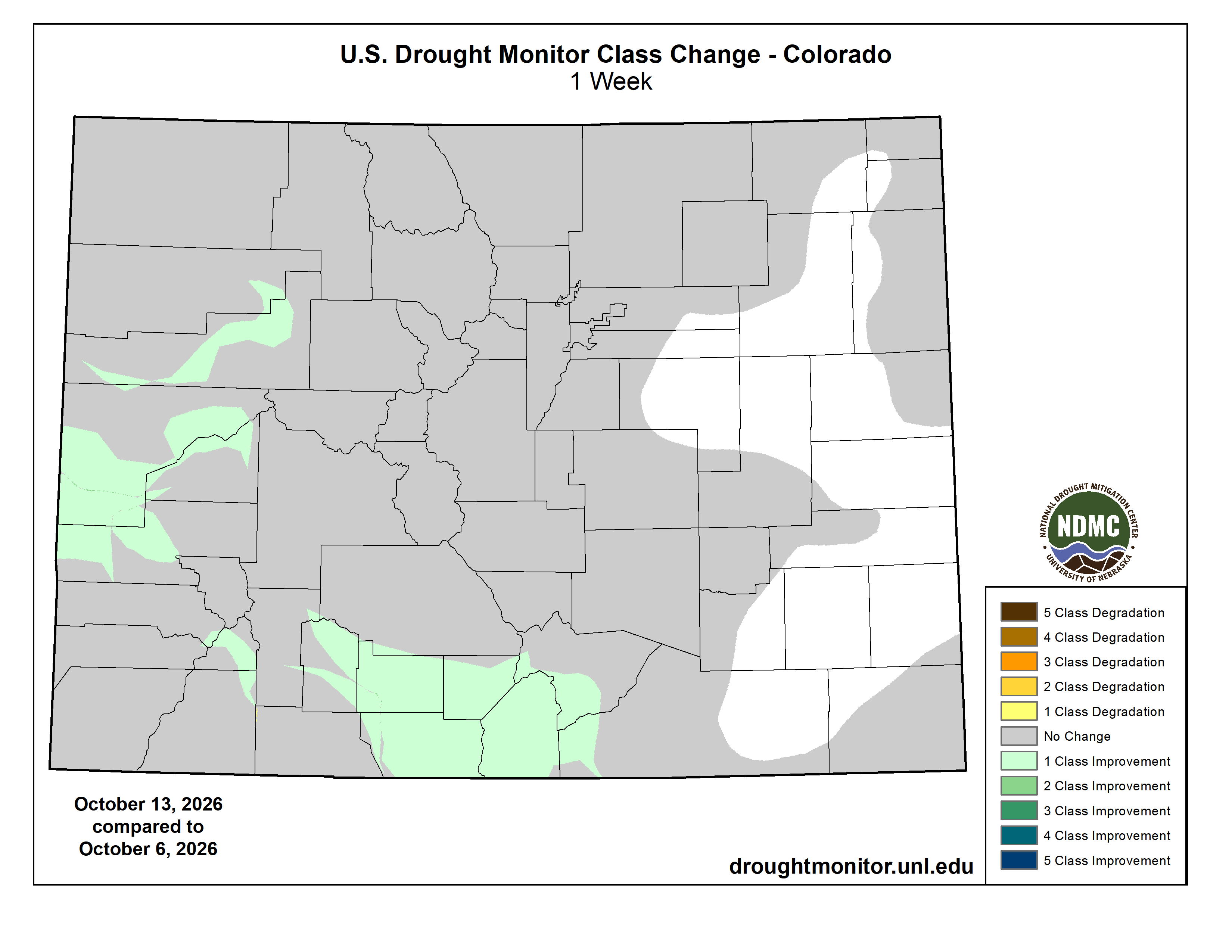
Drought conditions improved across portions of the West, with the most widespread improvements occurring across the Southwest and Intermountain West. A strong upper-level storm system interacting with moisture from the remnants of Hurricane Rachel brought beneficial precipitation to portions of the region Oct. 10–12. According to the National Hurricane Center, Rachel dissolved over the southwestern U.S. on Oct. 11, although its remnants continued to produce heavy rainfall and gusty winds across the Southwest. The storm system also brought early-season snow to portions of the northern Rockies, including Montana and higher elevations of Idaho, Wyoming and Utah. Temperatures were unusually warm ahead of the storm across portions of the northern Rockies before falling sharply as colder air moved into the region. In Great Falls, Montana, temperatures reached the lower 80s ahead of the storm before dropping into the upper 30s during its passage (NWS Great Falls, Montana). Farther south, Idaho Falls, Idaho, recorded a high of 47 degrees on Oct. 13, approximately 14 degrees below normal (NWS Pocatello, Idaho).
Significant snowfall occurred across portions of Montana Oct. 10–12, with reported totals including 11 inches at Black Pine SNOTEL near Philipsburg, Montana, 9.7 inches at Great Falls Airport in Montana, 9 inches near Bearmouth and 8 inches near Anaconda and Livingston, Montana. Higher-elevation observations included 1.50 inches of snow-water equivalent at Black Pine SNOTEL and 0.80 inches at Barker Lakes SNOTEL (NWS Missoula, Montana). In eastern Idaho, Idaho Falls recorded 1.30 inches of precipitation from Oct. 10–13, including 0.87 inches on Oct. 11 (NWS Pocatello, Idaho). Rain and higher-elevation snow also affected portions of Wyoming and Utah, while precipitation reached parts of Colorado and the Southwest. In contrast, much of the Pacific Northwest and portions of California remained relatively dry.
Drought improvements were concentrated across portions of Arizona, New Mexico, Utah and the Rocky Mountains of Colorado and Wyoming, where recent precipitation and improving short- and mid-term moisture conditions supported localized reductions in drought severity. In northern New Mexico, extreme drought (D3) was reduced, while portions of Utah experienced reductions in severe drought (D2) and extreme drought (D3). Additional improvements occurred across western and north-central Montana and portions of Idaho, where rain and mountain snow helped ease existing moisture deficits. In Arizona, localized improvements continued following substantial drought relief during the preceding week, although longer-term deficits persisted. Elsewhere, drought conditions remained largely unchanged across Washington, Oregon, California and much of Nevada. Despite these improvements, significant drought persisted across portions of the Great Basin, Southwest and northern Rockies…
South
Drought conditions were mixed across the South, with localized improvements in portions of Texas, Mississippi and Tennessee contrasting with widespread deterioration across the lower Mississippi Valley. Rainfall from Hurricane Isaias largely missed the region, with its precipitation only brushing portions of the Alabama-Mississippi border and leaving much of the drought-affected area without meaningful rainfall. Persistent precipitation deficits, unusually warm temperatures and elevated evaporative demand contributed to further drying across the region. These conditions followed record-breaking September warmth, when Texas, Oklahoma, Arkansas and Louisiana experienced their warmest September in 132 years of records, while Tennessee and Mississippi recorded their second- and third-warmest Septembers, respectively (NCEI).
Drought deterioration was concentrated along and near the Mississippi River Valley, extending from eastern Texas and southern Louisiana northward through central Mississippi, Arkansas and west-central Tennessee. Continued precipitation deficits and depleted soil moisture contributed to the expansion and intensification of drought, particularly across Arkansas and northern Louisiana, where exceptional drought (D4) expanded. In contrast, localized improvements occurred across western Texas, including portions of the Texas Panhandle near the New Mexico and Oklahoma borders, where lingering benefits from precipitation during preceding weeks supported reductions in drought severity. Additional improvements occurred across north-central Texas near the Oklahoma border. Farther east, localized improvements in Mississippi and Tennessee were associated with rainfall from Hurricane Isaias, although precipitation was insufficient to provide widespread relief across the lower Mississippi Valley…

Looking Ahead
Over the next five to seven days (Oct. 15-20), the Weather Prediction Center’s (WPC) five-day quantitative precipitation forecast shows a broad area of precipitation extending from the Southwest and southern Plains northeastward into the Midwest and Great Lakes. The heaviest precipitation is forecast from central and eastern Texas into Oklahoma, Arkansas and Missouri, where widespread totals of 2 to 5 inches are indicated, with localized amounts exceeding 5 inches. Additional precipitation of 1 to 3 inches is forecast across portions of the central Plains, Midwest, Ohio Valley and Great Lakes, with locally higher totals. Heavy precipitation is also forecast along the central Gulf Coast and offshore of Florida, while much of California, Nevada and the interior Southwest are expected to remain relatively dry.
The Climate Prediction Center’s 6-10 day temperature outlook (Oct. 19–23) favors above-normal temperatures across much of the central and eastern U.S., including the Great Plains, Midwest, Mississippi Valley, Southeast and Northeast. The strongest probabilities for above-normal temperatures are centered over portions of the central Plains and Mississippi Valley, where continued warmth could increase evaporative demand and contribute to additional drying in areas that miss significant precipitation. In contrast, below-normal temperatures are favored across portions of the western U.S., particularly along the West Coast and into the Great Basin and Southwest. The outlook favors near-normal temperatures, while above-normal temperatures are favored across portions of southeastern Alaska.
The Climate Prediction Center’s 6-10 day precipitation outlook (Oct. 19–23) favors above-normal precipitation across much of the western and central U.S., including portions of the West, northern and central Plains, Mississippi Valley and Upper Midwest. These areas may see additional opportunities for drought relief, particularly where recent precipitation has already improved short-term moisture conditions. In contrast, below-normal precipitation is favored across portions of the Northeast, Mid-Atlantic and Ohio and Tennessee Valleys, where continued dryness could reinforce existing precipitation deficits. Above-normal precipitation is also favored across much of Alaska, including portions of the Interior and Southeast Alaska.